Using High-Res. Orthoimagery for Environmental Change Detection & Analysis in Northern Alaska
|
|
|
- Britney Wade
- 5 years ago
- Views:
Transcription
1 Using High-Res. Orthoimagery for Environmental Change Detection & Analysis in Northern Alaska William F. Manley Leanne R. Lestak INSTAAR, University of Colorado INSTAAR, University of Colorado 1
2 Talk Outline ARCN Coastal Orthoimagery Evaluating Imagery for Use Create Your Own Imagery Opportunities & Challenges for ARCN 2
3 Introduction Orthorectified imagery was completed as part of a study on coastal erosion by the University of Colorado in collaboration with the Arctic Network Inventory and Monitoring Program. Beyond analysis of coastal change, the imagery will be of interest to land managers, scientists, and others for observation and study of natural features and ecosystems. 3
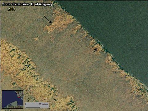
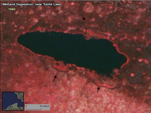
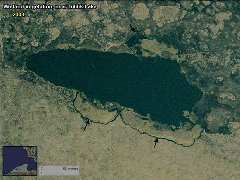
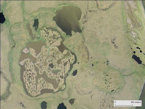
4 Goals The three, co-registered timeslices of imagery will be helpful to assess the status of environmental features, and to detect change in:! cultural resources and archeological sites! ecosystem components such as coastal zones, wetlands, geology, soils, permafrost, lake and stream hydrology, and vegetation assemblages! marine, terrestrial, and freshwater habitats for a variety of animals The imagery assists the goals of the NPS Arctic Network Inventory and Monitoring Program, which has a mission to "collect, compile, and synthesize scientific information about the arctic network of parks to facilitate their preservation, unimpaired, for future generations." 4

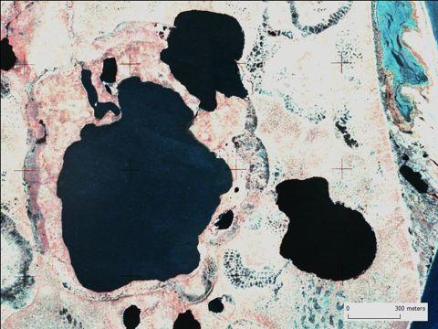
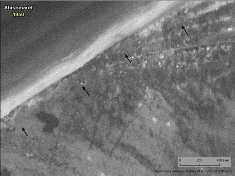
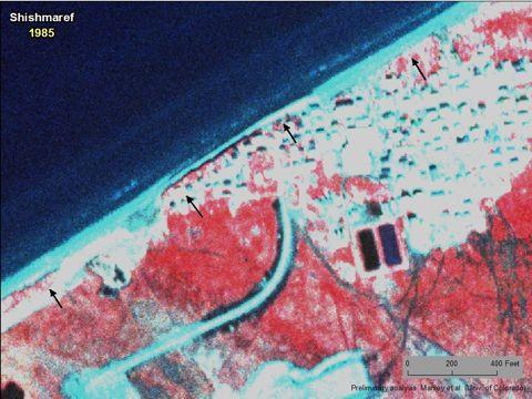
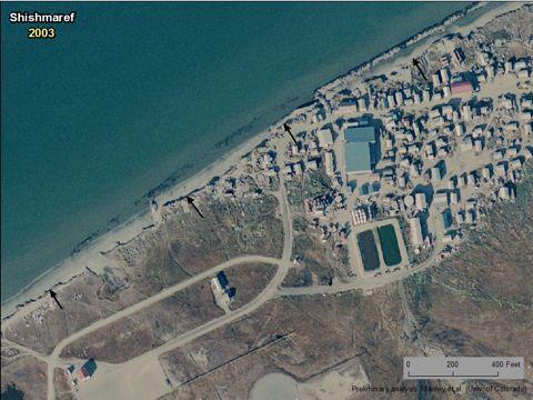
5 Study Area C h u k c h i S e a 5
 ca.")
6 Imagery orthophoto mosaic (94 GB) ca orthorectified photography for approx (53 GB) ca orthorectified photography for approx (15 GB) 6
 103 tiles, 94 GB: lots of imagery! highest res.")
7 from NOAA & NPS 1:24,000 natural color photos mosaic created by Aero-Metric 0.6 m resolution accuracy: 1.1 m (RMSE) 103 tiles, 94 GB: lots of imagery! highest res. in Alaska for this large of an area available to the public 7

8 5760 frames Color Color IR IR(USGS AHAP) 1.0 m res. 1:64,000 fully orthorectified to 2003 imagery using Imagine 1.0 m resolution 1.5 m accuracy (RMSE) 8
9 frames Black Black and & White White 1.0 m res. 1:43,000 fully orthorectified to 2003 imagery using Imagine 1.0 m resolution 2.0 m accuracy (RMSE) 9
10
11
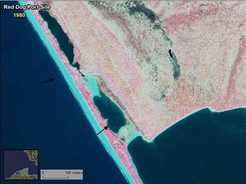
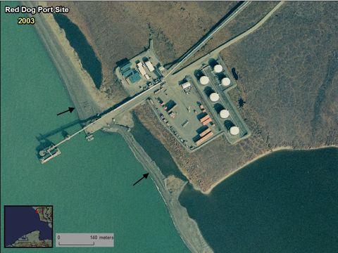
 over")
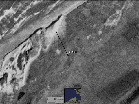
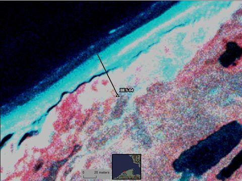
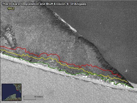
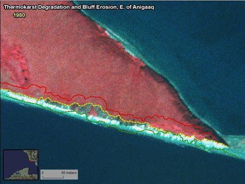
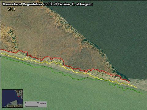
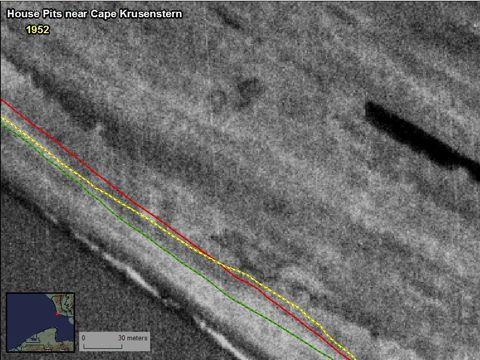
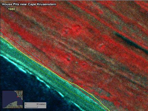
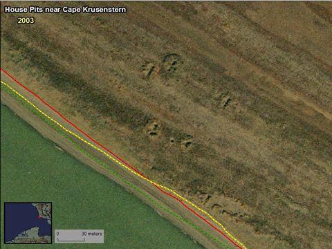
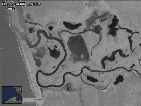
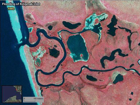
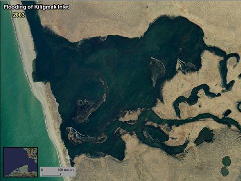
12 Bluff erosion, as an example of environmental change: 78 m (256 ft) over 54 years 12
13 13
14 14
15 15
16 16
17 17
18 18
19 19
20 20
21 21
22 22
23 23
24 24
25 25
26 26
27 27
28 28
29 29
30 30
31 31
32 32
33 33
34 34
35 35
36 36
37 Available to the Public: readme file 2003 orthophoto mosaic (103 tiles) image files (.tif,.tfw,.rrd) sid files (.sid,.sdw) metadata files (.html,.txt,.xml) ca orthorectified photos (57 frames) image files (.tif,.rrd) Note: georeferencing info. embedded in.tif metadata files (.html,.txt,.xml) ca orthorectified photos (108 frames) image files (.tif,.rrd) Note: georeferencing info. embedded in.tif metadata files (.html,.txt,.xml) accessory layers 2003 image extent showing NPS vs. NOAA source areas index shapefiles Note: attributed with details 2003 tiles ca frames ca frames See the README file and metadata files for more information. 37
38 Available to the Public, cont d: The three datasets are being made available on external hard drive. Contact: Arctic Network Data Manager National Park Service Arctic Network Inventory and Monitoring Program 4175 Geist Road Fairbanks, AK Now available also at 38
39 Questions: Arctic Network Data Manager National Park Service Arctic Network Inventory and Monitoring Program 4175 Geist Road Fairbanks, AK or William Manley, PhD Institute of Arctic and Alpine Research (INSTAAR) University of Colorado th Street Boulder, CO
40 Talk Outline ARCN Coastal Orthoimagery Evaluating Imagery for Use Create Your Own Imagery Opportunities & Challenges for ARCN 40
41 All Imagery Extent Imagery should cover entire Area of Interest (AOI) or selected target areas. Acquisition Date Recent for base imagery; at approx yr intervals and as far back in time as possible for photography. Typically acquired in summer; avoid sea ice and snow cover; consider phenology for ecological applications. Image Type Black & white is acceptable; true color or color infrared (CIR) is preferable; multispectral is best. Image Quality Avoid cloud cover or low-contrast imagery. Image Documentation & Metadata To the extent possible for assessment of suitability. File Format Typically as georeferenced.tif (GeoTIFF) for base imagery and.tif for scanned photography; avoid.jpg,.sid, or other lossy formats. Ownership, Licensing, & Availability for Use Preferably through unrestricted public license, and readily available on DVD or hard drive at minimal cost. 41
42 Base (Reference) Imagery Product Level Georeferencing Fully orthorectified, using best available DEM and ground control (GCP's). Horizontal Resolution 1.0 m or better?. Absolute Horizontal Accuracy Best possible; RMSE preferably less than approx. 10 m? for acceptable co-registration with independently acquired datasets. Projection & Datum As appropriate for present and future needs of project, and for use with other map layers; avoid resampling to other coordinate systems. 42
43 Historic Photography (digital scans) Scale 1:65,000 is acceptable; 1:24,000 or larger is preferable. Camera Calibration Information Calibrated focal length is most important; principle point coordinates can be assumed to be 0,0; film fiducial coordinates can be measured from prints, negatives, or scans; by far the best approach is to obtain full camera calibration reports. Calibration information can be difficult or time-consuming to compile from scans, negatives, film cans, metadata, online databases, or by communication with other organizations or agencies. Scan Resolution At, or better than, planned output resolution. Recommended: 1800 dpi (14 micron) for 1:65,000 scale (ca. 0.9 m); 1800 dpi (14 micron) for 1:45,000 scale (ca 0.6 m), or better; 1800 dpi (14 micron) for 1:24,000 scale (ca. 0.3 m), or better; 1200 dpi (21 micron) or better for larger scales. Scans should include full photo frame, including side or corner fiducial marks. Horizontal Resolution Recommended resolutions for orthorectified output: 1.0 m for 1:65,000 scale; 0.6 m for 1:45,000 scale; 0.5 m or better for larger scales, up to reasonable file size per image of approx GB Relative Horizontal Accuracy RMSE for orthorectified output, relative to base imagery, should be less than approx. 20 m, and preferably 5 m or better to minimize errors for detailed analysis. Projection & Datum Same as base imagery. Number of frames For a given Area of Interest, larger scales entail a significant increase in number of frames and processing. 43
44 Bottom Line: Extent, Date, Resolution and Accuracy needed for intended analysis. 44
45 Talk Outline ARCN Coastal Orthoimagery Evaluating Imagery for Use Create Your Own Imagery Opportunities & Challenges for ARCN 45

46 What is a GCP? Ground control point surveyed in the field on a photo-identifiable feature... 46

47 Start From Scratch: at least 5 GCP s per frame 47
48 Start with well-orthorectified base imagery and use image-to-image control points basic georeferencing scan + 1 control point = georeferenced doesn t remove distortions from camera or terrain errors > 300 m basic georectification -- polynomial transformation (ie., ArcMap) scan + control points = georectified doesn t remove distortions from camera or terrain errors approx m full orthorectification -- with aerial triangulation (ie., ERDAS Imagine) scan + camera calibration information + control points + good DEM = orthorectified removes distortions from camera and terrain errors approx m 48
49 Bottom Line: Measure errors with independent check points ArcGIS NEAR command Create FGDC metadata Share the data 49
50 Talk Outline ARCN Coastal Orthoimagery Evaluating Imagery for Use Create Your Own Imagery Opportunities & Challenges for ARCN 50
51 Availability of High-Res. Orthoimagery for N. Alaska ARCN coastal imagery IKONOS for the ARCN parks USGS DOQQ s (NPRA; might cover part of Noatak) Intermap IFSAR ORRI (NPRA; might cover part of Gates) Commercial imagery ($$) others?? Up and coming: the Statewide Digital Mapping Initiative! 51
52 For ARCN I&M Goals: Base imagery = inventory! mapping, visualization, analysis Other years of imagery = monitoring! repeat orthoimagery for time-series detection and analysis of environmental change 52
Orthoimagery Standards. Chatham County, Georgia. Jason Lee and Noel Perkins
 1 Orthoimagery Standards Chatham County, Georgia Jason Lee and Noel Perkins 2 Table of Contents Introduction... 1 Objective... 1.1 Data Description... 2 Spatial and Temporal Environments... 3 Spatial Extent
Planet Labs Inc 2017 Page 2
 SKYSAT IMAGERY PRODUCT SPECIFICATION: ORTHO SCENE LAST UPDATED JUNE 2017 SALES@PLANET.COM PLANET.COM Disclaimer This document is designed as a general guideline for customers interested in acquiring Planet
Baldwin and Mobile Counties, AL Orthoimagery Project Report. Submitted: March 23, 2016
 2015 Orthoimagery Project Report Submitted: Prepared by: Quantum Spatial, Inc 523 Wellington Way, Suite 375 Lexington, KY 40503 859-277-8700 Page i of iii Contents Project Report 1. Summary / Scope...
MSB Imagery Program FAQ v1
 MSB Imagery Program FAQ v1 (F)requently (A)sked (Q)uestions 9/22/2016 This document is intended to answer commonly asked questions related to the MSB Recurring Aerial Imagery Program. Table of Contents
Recurring Aerial Imagery Acquisition Program
 Recurring Aerial Imagery Acquisition Program MSB Project No. 16-130 Report 4 of 5 Analysis of Aerial Imagery Acquisition Options Prepared By: Kinney Engineering, LLC 3909 Arctic Blvd, Ste 400 Anchorage,
ENVI Tutorial: Orthorectifying Aerial Photographs
 ENVI Tutorial: Orthorectifying Aerial Photographs Table of Contents OVERVIEW OF THIS TUTORIAL...2 ORTHORECTIFYING AERIAL PHOTOGRAPHS IN ENVI...2 Building the interior orientation...3 Building the exterior
What is Photogrammetry
 Photogrammetry What is Photogrammetry Photogrammetry is the art and science of making accurate measurements by means of aerial photography: Analog photogrammetry (using films: hard-copy photos) Digital
TEMPORAL ANALYSIS OF MULTI EPOCH LANDSAT GEOCOVER IMAGES IN ZONGULDAK TESTFIELD
 TEMPORAL ANALYSIS OF MULTI EPOCH LANDSAT GEOCOVER IMAGES IN ZONGULDAK TESTFIELD Şahin, H. a*, Oruç, M. a, Büyüksalih, G. a a Zonguldak Karaelmas University, Zonguldak, Turkey - (sahin@karaelmas.edu.tr,
CanImage. (Landsat 7 Orthoimages at the 1: Scale) Standards and Specifications Edition 1.0
 Standards and Specifications Edition 1.0") CanImage (Landsat 7 Orthoimages at the 1:50 000 Scale) Standards and Specifications Edition 1.0 Centre for Topographic Information Customer Support Group 2144 King Street West, Suite 010 Sherbrooke, QC
CanImage (Landsat 7 Orthoimages at the 1:50 000 Scale) Standards and Specifications Edition 1.0 Centre for Topographic Information Customer Support Group 2144 King Street West, Suite 010 Sherbrooke, QC
DRAPP 2014 DATA ACCEPTANCE TESTING (DAT) SCOPE OF WORK August 13, 2013
 SCOPE OF WORK August 13, 2013") DRAPP 2014 DATA ACCEPTANCE TESTING (DAT) SCOPE OF WORK August 13, 2013 Contents Background... 2 Summary... 2 Definitions... 2 Services to be Rendered... 3 Overview... 3 Geographic Extent... 3 Tasks and
DRAPP 2014 DATA ACCEPTANCE TESTING (DAT) SCOPE OF WORK August 13, 2013 Contents Background... 2 Summary... 2 Definitions... 2 Services to be Rendered... 3 Overview... 3 Geographic Extent... 3 Tasks and
PLANET IMAGERY PRODUCT SPECIFICATION: PLANETSCOPE & RAPIDEYE
 PLANET IMAGERY PRODUCT SPECIFICATION: PLANETSCOPE & RAPIDEYE LAST UPDATED OCTOBER 2016 SALES@PLANET.COM PLANET.COM Table of Contents LIST OF FIGURES 3 LIST OF TABLES 3 GLOSSARY 5 1. OVERVIEW OF DOCUMENT
PLANET IMAGERY PRODUCT SPECIFICATIONS PLANET.COM
 PLANET IMAGERY PRODUCT SPECIFICATIONS SUPPORT@PLANET.COM PLANET.COM LAST UPDATED JANUARY 2018 TABLE OF CONTENTS LIST OF FIGURES 3 LIST OF TABLES 4 GLOSSARY 5 1. OVERVIEW OF DOCUMENT 7 1.1 Company Overview
Acquisition of Aerial Photographs and/or Satellite Imagery
 Acquisition of Aerial Photographs and/or Satellite Imagery Acquisition of Aerial Photographs and/or Imagery From time to time there is considerable interest in the purchase of special-purpose photography
Lab #10 Digital Orthophoto Creation (Using Leica Photogrammetry Suite)
") Lab #10 Digital Orthophoto Creation (Using Leica Photogrammetry Suite) References: Leica Photogrammetry Suite Project Manager: Users Guide, Leica Geosystems LLC. Leica Photogrammetry Suite 9.2 Introduction:
Lab #10 Digital Orthophoto Creation (Using Leica Photogrammetry Suite) References: Leica Photogrammetry Suite Project Manager: Users Guide, Leica Geosystems LLC. Leica Photogrammetry Suite 9.2 Introduction:
Project Planning and Cost Estimating
 CHAPTER 17 Project Planning and Cost Estimating 17.1 INTRODUCTION Previous chapters have outlined and detailed technical aspects of photogrammetry. The basic tasks and equipment required to create various
Metro Area Planning Agency. Request for Proposal Omaha-Lincoln Metro Area Imagery Project
 Metro Area Planning Agency Request for Proposal 2018 Omaha-Lincoln Metro Area Imagery Project 1. General Info 1.1. Objective The Metro Area Planning Agency ( MAPA ) in Omaha is soliciting proposals from
[GEOMETRIC CORRECTION, ORTHORECTIFICATION AND MOSAICKING]
![[GEOMETRIC CORRECTION, ORTHORECTIFICATION AND MOSAICKING]](/thumbs/78/78211997.jpg "[GEOMETRIC CORRECTION, ORTHORECTIFICATION AND MOSAICKING]") 2013 Ogis-geoInfo Inc. IBEABUCHI NKEMAKOLAM.J [GEOMETRIC CORRECTION, ORTHORECTIFICATION AND MOSAICKING] [Type the abstract of the document here. The abstract is typically a short summary of the contents
2013 Ogis-geoInfo Inc. IBEABUCHI NKEMAKOLAM.J [GEOMETRIC CORRECTION, ORTHORECTIFICATION AND MOSAICKING] [Type the abstract of the document here. The abstract is typically a short summary of the contents
Managing and Monitoring Intertidal Oyster Reefs with Remote Sensing in Coastal South Carolina
 Managing and Monitoring Intertidal Oyster Reefs with Remote Sensing in Coastal South Carolina A cooperative effort between: Coastal Services Center South Carolina Department of Natural Resources City of
DETAILED CHANGE DETECTION USING HIGH SPATIAL RESOLUTION FRAME CENTER MATCHED AERIAL PHOTOGRAPHY INTRODUCTION
 DETAILED CHANGE DETECTION USING HIGH SPATIAL RESOLUTION FRAME CENTER MATCHED AERIAL PHOTOGRAPHY Lloyd L. Coulter, Steven J. Lathrop, and Douglas A. Stow Department of Geography San Diego State University
MAPPING DAMAGES CAUSED BY THE OCTOBER 2003 WILDFIRES IN CALIFORNIA
 MAPPING DAMAGES CAUSED BY THE OCTOBER 2003 WILDFIRES IN CALIFORNIA Louis Demargne & Mitch Jordan EarthData International 7320 Executive Way, Frederick, MD 21702 ABSTRACT EarthData, in coordination with
Please show the instructor your downloaded index files and orthoimages.
 Student Exercise 1: Sandia Forest Infestation Acquiring Orthophotos and Satellite Imagery Please show the instructor your downloaded index files and orthoimages. Objectives: Determine appropriate imagery
THE NATIONAL AERIAL PHOTOGRAPHY PROGRAM: AN AERIAL SYSTEM IN SUPPORT OF THE UNITED STATES SPATIAL DATA INFRASTRUCTURE
 THE NATIONAL AERIAL PHOTOGRAPHY PROGRAM: AN AERIAL SYSTEM IN SUPPORT OF THE UNITED STATES SPATIAL DATA INFRASTRUCTURE Donald L. Light U.S. Geological Survey MS 511 National Center Reston, Virginia 22092
Sample Copy. Not For Distribution.
 Photogrammetry, GIS & Remote Sensing Quick Reference Book i EDUCREATION PUBLISHING Shubham Vihar, Mangla, Bilaspur, Chhattisgarh - 495001 Website: www.educreation.in Copyright, 2017, S.S. Manugula, V.
Earth Observations from Space U.S. Geological Survey
 Earth Observations from Space U.S. Geological Survey Geography Land Remote Sensing Program Dr. Bryant Cramer April 1, 2009 U.S. Department of the Interior U.S. Geological Survey USGS Landsat Historical
The Airphoto Ortho Suite is an add-on to Geomatica. It requires Geomatica Core or Geomatica Prime as a pre-requisite.
 Airphoto Ortho Suite The Airphoto Ortho Suite includes rigorous models used to correct the geometry of analogue and digital/video cameras and to produce orthorectified air photos. These models compensate
Preserving the Past: The Development of a Digital Historical Aerial Photography Archive
 DONALD E. LUMAN Preserving the Past: The Development of a Digital Historical Aerial Photography Archive The University of Illinois Map and Geography Library maintains a collection of approximately 60,000
OLC Turnbull. wsidata.com
 OLC Turnbull wsidata.com August 26, 2013 Base station set up over control TURN_03 Data collected for: Department of Geology and Mineral Industries 800 NE Oregon Street Suite 965 Portland, OR 97232 Prepared
1. Introduction 2. Tectonics of NE Iceland Krafla rifting crisis (constraints from spy image matching)
") 1. Introduction 2. Tectonics of NE Iceland 3. 1975-1984 Krafla rifting crisis (constraints from spy image matching) 4. 1975-1984 Krafla rifting crisis (constraints from aerial photos) 5. Conclusions Tuesday
1. Introduction 2. Tectonics of NE Iceland 3. 1975-1984 Krafla rifting crisis (constraints from spy image matching) 4. 1975-1984 Krafla rifting crisis (constraints from aerial photos) 5. Conclusions Tuesday
2019 NYSAPLS Conf> Fundamentals of Photogrammetry for Land Surveyors
 2019 NYSAPLS Conf> Fundamentals of Photogrammetry for Land Surveyors George Southard GSKS Associates LLC Introduction George Southard: Master s Degree in Photogrammetry and Cartography 40 years working
Statewide Orthoimagery 2010 Data Delivery (excerpts for imagery review)
") Statewide Orthoimagery 2010 Data Delivery (excerpts for imagery review) Center for Geographic Information and Analysis Tim Johnson, Director March 2011 Project In Brief City of Durham PSAP Funded by NC
Statewide Orthoimagery 2010 Data Delivery (excerpts for imagery review) Center for Geographic Information and Analysis Tim Johnson, Director March 2011 Project In Brief City of Durham PSAP Funded by NC
Standing Up NAIP and Landsat Image Services as a Processing Resource. Andrew Leason
 Standing Up NAIP and Landsat Image Services as a Processing Resource Andrew Leason NAIP and Landsat services Differences Different general uses - Landsat - Available from USGS - Designed as an analytical
Tidal Datums & Coastal Profiles. DGGS Coastal Hazards Program - Fairbanks, AK Program Manager: Nicole Kinsman
 Tidal Datums & Coastal Profiles DGGS Coastal Hazards Program - Fairbanks, AK Program Manager: Nicole Kinsman nicole.kinsman@alaska.gov 907-451-5026 Overview AOOS-funded DGGS Projects: 1) Port Heiden Short-Term
Aerial photography: Principles. Frame capture sensors: Analog film and digital cameras
 Aerial photography: Principles Frame capture sensors: Analog film and digital cameras Overview Introduction Frame vs scanning sensors Cameras (film and digital) Photogrammetry Orthophotos Air photos are
News on Image Acquisition for the CwRS Campaign new sensors and changes
 Control Methods Workshop: 6-8 / 4 / 2009 [CwRS KO Meeting Campaign 2009] 1 News on Image Acquisition for the CwRS Campaign 2009 - new sensors and changes Pär Johan Åstrand, Joanna Nowak, Maria Erlandsson
OUR INDUSTRIAL LEGACY WHAT ARE WE LEAVING OUR CHILDREN REAAA Roadshow Taupo, August 2016 Young presenter s competition
 OUR INDUSTRIAL LEGACY WHAT ARE WE LEAVING OUR CHILDREN Preserving the country s aerial photography archive for future generations Abstract For over eighty years, aerial photography has captured the changing
Landsat 8. Snabba leveranser av bilder till användarna. Lars-Åke Edgardh. tisdag 9 april 13
 Landsat 8 Snabba leveranser av bilder till användarna Lars-Åke Edgardh Keystone A single system for: Many sensors Many types of clients Hides the complexity of sensors. Specialised on: Services High volume
Acquisition of Aerial Photographs and/or Imagery
 Acquisition of Aerial Photographs and/or Imagery Acquisition of Aerial Photographs and/or Imagery From time to time there is considerable interest in the purchase of special-purpose photography contracted
LPIS Orthoimagery An assessment of the Bing imagery for LPIS purpose
 LPIS Orthoimagery An assessment of the Bing imagery for LPIS purpose Slavko Lemajić Wim Devos, Pavel Milenov GeoCAP Action - MARS Unit - JRC Ispra Tallinn, 24 th November 2011 Outline JRC`s Ortho specifications
Active and Passive Microwave Remote Sensing
 Active and Passive Microwave Remote Sensing Passive remote sensing system record EMR that was reflected (e.g., blue, green, red, and near IR) or emitted (e.g., thermal IR) from the surface of the Earth.
Photogrammetry. Lecture 4 September 7, 2005
 Photogrammetry Lecture 4 September 7, 2005 What is Photogrammetry Photogrammetry is the art and science of making accurate measurements by means of aerial photography: Analog photogrammetry (using films:
THREE-DIMENSIONAL MAPPING USING BOTH AIRBORNE AND SPACEBORNE IFSAR TECHNOLOGIES ABSTRACT INTRODUCTION
 THREE-DIMENSIONAL MAPPING USING BOTH AIRBORNE AND SPACEBORNE IFSAR TECHNOLOGIES Trina Kuuskivi Manager of Value Added Products and Services, Intermap Technologies Corp. 2 Gurdwara Rd, Suite 200, Ottawa,
APPLICATIONS AND LESSONS LEARNED WITH AIRBORNE MULTISPECTRAL IMAGING
 APPLICATIONS AND LESSONS LEARNED WITH AIRBORNE MULTISPECTRAL IMAGING James M. Ellis and Hugh S. Dodd The MapFactory and HJW Walnut Creek and Oakland, California, U.S.A. ABSTRACT Airborne digital frame
PLANET IMAGERY PRODUCT SPECIFICATION: PLANETSCOPE & RAPIDEYE
 PLANET IMAGERY PRODUCT SPECIFICATION: PLANETSCOPE & RAPIDEYE LAST UPDATED FEBRUARY 2017 SALES@PLANET.COM PLANET.COM Table of Contents LIST OF FIGURES 3 LIST OF TABLES 3 GLOSSARY 5 1. OVERVIEW OF DOCUMENT
Remote Sensing for Rangeland Applications
 Remote Sensing for Rangeland Applications Jay Angerer Ecological Training June 16, 2012 Remote Sensing The term "remote sensing," first used in the United States in the 1950s by Ms. Evelyn Pruitt of the
Flood modelling and management. Glasgow University. 8 September Paul Shaw - GeoVision
 Flood modelling and management Glasgow University 8 September 2004 Paul Shaw - GeoVision How important are heights in flood modelling? Comparison of data collection technologies GPS - Global Positioning
Image Registration Exercise ESPM 5295
 Background: We often digitize data from orthorectifed aerial photographs. These photographs have been processed to remove tilt and terrain errors to the level practical and required by the original contract.
ACQUISITION GUIDELINES FOR DIGITAL IMAGERY AND TERRAIN DATA FOR THE SAN DIEGO REGION
 ACQUISITION GUIDELINES FOR DIGITAL IMAGERY AND TERRAIN DATA FOR THE SAN DIEGO REGION April 2007 Prepared by The Imagery Subcommittee of The San Diego Regional GIS Council TABLE OF CONTENTS INTRODUCTION...
ACQUISITION GUIDELINES FOR DIGITAL IMAGERY AND TERRAIN DATA FOR THE SAN DIEGO REGION
 ACQUISITION GUIDELINES FOR DIGITAL IMAGERY AND TERRAIN DATA FOR THE SAN DIEGO REGION December 2003 Prepared by The Imagery Subcommittee of The San Diego Regional GIS Council TABLE OF CONTENTS INTRODUCTION...IV
SAR Imagery: Airborne or Spaceborne? Presenter: M. Lorraine Tighe PhD
 SAR Imagery: Airborne or Spaceborne? Presenter: M. Lorraine Tighe PhD Introduction The geospatial community has seen a plethora of spaceborne SAR imagery systems where there are now extensive archives
WorldDEM4Ortho. Technical Product Specification. Version 1.4. AIRBUS DEFENCE AND SPACE Intelligence
 Technical Product Specification Version 1.4 AIRBUS DEFENCE AND SPACE Intelligence Table of Contents Table of Contents... 2 List of Figures... 3 List of Tables... 3 Abbreviations... 4 References... 4 1
ENVI Orthorectification Module
 ENVI Orthorectification Module Orthorectify your imagery quickly and easily. CREASO - your partner for visual information solutions Rigorous Orthorectification. Simple Workflow. Trusted Method. The Need
Detecting and Mapping Invasive Phragmites australis in the Coastal Great Lakes with ALOS PALSAR Imagery
 Detecting and Mapping Invasive Phragmites australis in the Coastal Great Lakes with ALOS PALSAR Imagery Brian Huberty U.S Fish & Wildlife Service Region 3 Ecological Services Laura L. Bourgeau-Chavez,
THE HYDROLOGIC IMPACT OF THE VERMONT INTERSTATE HIGHWAY SYSTEM. A Thesis Progress Report. Analeisha Vang. The Faculty of the Geology Department
 THE HYDROLOGIC IMPACT OF THE VERMONT INTERSTATE HIGHWAY SYSTEM A Thesis Progress Report by Analeisha Vang to The Faculty of the Geology Department of The University of Vermont November 2012 Accepted by
PRODUCT LEVELS 2 Georectified Products... 3 Orthorectified Products... 4 Stereo Products... 5 Off-the-Shelf Products... 6
 i TABLE OF CONTENTS INTRODUCTION 1 PRODUCT LEVELS 2 Georectified Products... 3 Orthorectified Products... 4 Stereo Products... 5 Off-the-Shelf Products... 6 SPECIFICATIONS 7 Spectral Range... 7 Clouds...
Lesson 3: Working with Landsat Data
 Lesson 3: Working with Landsat Data Lesson Description The Landsat Program is the longest-running and most extensive collection of satellite imagery for Earth. These datasets are global in scale, continuously
Up, Up, and Away!! Marine Robotics and Remote Duke University Marine Laboratory. David W. Johnston
 Up, Up, and Away!! Marine Robotics and Remote Sensing @ Duke University Marine Laboratory David W. Johnston Assistant Professor of the Practice of Marine Conservation & Ecology! Division of Marine Science
The Normal Baseline. Dick Gent Law of the Sea Division UK Hydrographic Office
 The Normal Baseline Dick Gent Law of the Sea Division UK Hydrographic Office 2 The normal baseline for measuring the breadth of the territorial sea is the low water line along the coast as marked on large
Map and Drawing Standards for the South Pacific Division Regulatory Program
 Map and Drawing Standards for the South Pacific Division Regulatory Program Hollis Jencks Project Manager, Nevada/Utah Section Sacramento District Regulatory Program Workshop 31 May 2018 US Army Corps
GeoBase Raw Imagery Data Product Specifications. Edition
 GeoBase Raw Imagery 2005-2010 Data Product Specifications Edition 1.0 2009-10-01 Government of Canada Natural Resources Canada Centre for Topographic Information 2144 King Street West, suite 010 Sherbrooke,
NPS Inventory and Monitoring Program
 NPS Inventory and Monitoring Program Metrics and Protocols Monitoring Tidal Marsh Condition Tidal Marsh Resiliency Coordination Workshop U.S. Fish & Wildlife Service, Hadley, MA Dec 8-9, 2014 Northeast
NRS 415 Remote Sensing of Environment
 NRS 415 Remote Sensing of Environment 1 High Oblique Perspective (Side) Low Oblique Perspective (Relief) 2 Aerial Perspective (See What s Hidden) An example of high spatial resolution true color remote
ENVI Orthorectification Module
 Visual Information Solutions ENVI Orthorectification Module Orthorectify Your Imagery Quickly and Easily. Rigorous Orthorectification. Simple Workflow. Trusted Method. The Need for Orthorectification Satellite
Summary of the VHR image acquisition Campaign 2014 and new sensors for 2015
 Summary of the VHR image acquisition Campaign 2014 and new sensors for 2015 Michaela Neumann, George Ellis, Samuel Bärisch, Blanka Vajsova 19 November 2014, Dresden 20th MARS Conference Presentation Outline
EnsoMOSAIC Aerial mapping tools
 EnsoMOSAIC Aerial mapping tools Jakarta and Kuala Lumpur, 2013 Contents MosaicMill MM Application examples Software introduction System introduction Rikola HS sensor UAV platform examples SW Syst HS UAV
Lesson 4: Photogrammetry
 This work by the National Information Security and Geospatial Technologies Consortium (NISGTC), and except where otherwise Development was funded by the Department of Labor (DOL) Trade Adjustment Assistance
Application of GIS for earthquake hazard and risk assessment: Kathmandu, Nepal. Part 2: Data preparation GIS CASE STUDY
 GIS CASE STUDY Application of GIS for earthquake hazard and risk assessment: Kathmandu, Nepal Part 2: Data preparation Cees van Westen (E-mail : westen@itc.nl) Siefko Slob (E-mail: Slob@itc.nl) Lorena
Hi-resolution Data in a Low-resolution Landscape:
 Hi-resolution Data in a Low-resolution Landscape: Squeezing More Value from Digital Airphotos when Ancillary Data are Lacking Andrew Balser, October 17, 2008 Airphotos versus Satellite Imagery: Trade-offs
Na6onal Agricultural Imagery Program (NAIP)
") Spa$al Workshop: Part 3 Other imagery sources CIR imagery NAIP, TM, Lidar/Radar NEXTMAP, others SNAMP Data sharing server How to access SNAMP data SNAMP website: Stay in touch! Na6onal Agricultural Imagery
Spa$al Workshop: Part 3 Other imagery sources CIR imagery NAIP, TM, Lidar/Radar NEXTMAP, others SNAMP Data sharing server How to access SNAMP data SNAMP website: Stay in touch! Na6onal Agricultural Imagery
ACCURACY ASSESSMENT OF DIRECT GEOREFERENCING FOR PHOTOGRAMMETRIC APPLICATIONS ON SMALL UNMANNED AERIAL PLATFORMS
 ACCURACY ASSESSMENT OF DIRECT GEOREFERENCING FOR PHOTOGRAMMETRIC APPLICATIONS ON SMALL UNMANNED AERIAL PLATFORMS O. Mian a, J. Lutes a, G. Lipa a, J. J. Hutton a, E. Gavelle b S. Borghini c * a Applanix
Progress Towards the Seamless Combination of Bathymetric and Topographic Data in New Zealand
 Progress Towards the Seamless Combination of Bathymetric and Topographic Data in New Zealand Matt Amos Senior Technical Advisor National Geodetic Office Introduction Datasets usually defined in terms of
Lecture 6: Multispectral Earth Resource Satellites. The University at Albany Fall 2018 Geography and Planning
 Lecture 6: Multispectral Earth Resource Satellites The University at Albany Fall 2018 Geography and Planning Outline SPOT program and other moderate resolution systems High resolution satellite systems
29 th Annual Louisiana RS/GIS Workshop April 23, 2013 Cajundome Convention Center Lafayette, Louisiana
 Landsat Data Continuity Mission 29 th Annual Louisiana RS/GIS Workshop April 23, 2013 Cajundome Convention Center Lafayette, Louisiana http://landsat.usgs.gov/index.php# Landsat 5 Sets Guinness World Record
Managing Imagery and Raster Data. Peter Becker
 Managing Imagery and Raster Data Peter Becker ArcGIS is a Comprehensive Imagery Platform Empowering you to make informed decisions System of Engagement System of Insight Extract Information from Imagery
Tutorial 10 Information extraction from high resolution optical satellite sensors
 Tutorial 10 Information extraction from high resolution optical satellite sensors Karsten Jacobsen 1, Emmanuel Baltsavias 2, David Holland 3 1 University of, Nienburger Strasse 1, D-30167, Germany, jacobsen@ipi.uni-hannover.de
MPA Baseline Program. Annual Progress Report
 MPA Baseline Program Annual Progress Report Principal Investigators please use this form to submit your MPA Baseline Program project annual report, including an update on activities completed over the
ABSTRACT. for regulatory erosion rate calculation does not take advantage of emerging GIS,
 ABSTRACT ZINK, JASON MICHAEL. Using Modern Photogrammetric Techniques to Map Historical Shorelines and Analyze Shoreline Change Rates: Case Study on Bodie Island, North Carolina. (Under the direction of
NUCLEAR WASTE RELATED SATELLITE MAPPING IN NORTHWEST RUSSIA
 NUCLEAR WASTE RELATED SATELLITE MAPPING IN NORTHWEST RUSSIA O. B.Dick a, *, O. Reistad b, S. Hustveit b, G. Grepstad c, Frits Steenhuisen d a Geomatics section - IMT, Norwegian University of Life Sciences,
SAR Othorectification and Mosaicking
 White Paper SAR Othorectification and Mosaicking John Wessels: Senior Scientist PCI Geomatics SAR Othorectification and Mosaicking This study describes the high-speed orthorectification and mosaicking
Guidelines for the Acquisition of Aerial Photography for Digital Photo-Interpretation of Submerged Aquatic Vegetation (SAV)
") Guidelines for the Acquisition of Aerial Photography for Digital Photo-Interpretation of Submerged Aquatic Vegetation (SAV) by Sam S. Jackson, Mark R. Graves, and Deborah J. Shafer PURPOSE: Monitoring
Guidelines for the Acquisition of Aerial Photography for Digital Photo-Interpretation of Submerged Aquatic Vegetation (SAV) by Sam S. Jackson, Mark R. Graves, and Deborah J. Shafer PURPOSE: Monitoring
MPA Baseline Program. Annual Progress Report
 MPA Baseline Program Annual Progress Report Principal Investigators - please use this form to submit your MPA Baseline Program project annual report, including an update on activities completed over the
Remote sensing image correction
 Remote sensing image correction Introductory readings remote sensing http://www.microimages.com/documentation/tutorials/introrse.pdf 1 Preprocessing Digital Image Processing of satellite images can be
ASTER GDEM Readme File ASTER GDEM Version 1
 I. Introduction ASTER GDEM Readme File ASTER GDEM Version 1 The Advanced Spaceborne Thermal Emission and Reflection Radiometer (ASTER) Global Digital Elevation Model (GDEM) was developed jointly by the
Introduction to Remote Sensing
 Introduction to Remote Sensing Spatial, spectral, temporal resolutions Image display alternatives Vegetation Indices Image classifications Image change detections Accuracy assessment Satellites & Air-Photos
RapidEye Initial findings of Geometric Image Quality Analysis. Joanna Krystyna Nowak Da Costa
 RapidEye Initial findings of Geometric Image Quality Analysis Joanna Krystyna Nowak Da Costa EUR 24129 EN - 2009 The mission of the JRC-IPSC is to provide research results and to support EU policy-makers
Thermal Infrared Remote Sensing Pilot Test
 (FERC No. 14241) Thermal Infrared Remote Sensing Pilot Test Prepared for Prepared by URS Corporation Watershed Sciences Inc. February 2013 TABLE OF CONTENTS Summary... iv 1. Introduction...1 2. Study Objectives...1
Wetlands Investigation Utilizing GIS and Remote Sensing Technology for Lucas County, Ohio: a hybrid analysis.
 Wetlands Investigation Utilizing GIS and Remote Sensing Technology for Lucas County, Ohio: a hybrid analysis. Update on current wetlands research in GISAG Nathan Torbick Spring 2003 Component One Remote
Annual Progress Report for Makaha Valley Vegetation Mapping Analysis Project Update: January 1, 2014 September 30 th, 2014
 Annual Progress Report for Makaha Valley Vegetation Mapping Analysis Project Update: January 1, 2014 September 30 th, 2014 Evaluation of Three Very High Resolution Remote Sensing Technologies for Vegetation
746A27 Remote Sensing and GIS. Multi spectral, thermal and hyper spectral sensing and usage
 746A27 Remote Sensing and GIS Lecture 3 Multi spectral, thermal and hyper spectral sensing and usage Chandan Roy Guest Lecturer Department of Computer and Information Science Linköping University Multi
MULTI-TEMPORAL IMAGE ANALYSIS OF THE COASTAL WATERSHED, NH INTRODUCTION
 MULTI-TEMPORAL IMAGE ANALYSIS OF THE COASTAL WATERSHED, NH Meghan Graham MacLean, PhD Student Alexis M. Rudko, MS Student Dr. Russell G. Congalton, Professor Department of Natural Resources and the Environment
British Columbia Specifications and Guidelines for Geomatics Digital Orthophoto
 British Columbia Specifications and Guidelines for Geomatics Digital Orthophoto Content Series Volume 7 Digital Orthophoto Specifications Release 1.0 May 1997 1 Base Mapping and Geomatic Services Branch
Working with Elevation Services. Cody Benkelman
 Working with Elevation Services Cody Benkelman Outline ArcGIS Online World Elevation & 3D Elevation Cache for Pro What is included? - Data and Tools How can I use it? - Modes of use - Client Applications
GEO 428: DEMs from GPS, Imagery, & Lidar Tuesday, September 11
 GEO 428: DEMs from GPS, Imagery, & Lidar Tuesday, September 11 Global Positioning Systems GPS is a technology that provides Location coordinates Elevation For any location with a decent view of the sky
Peace Project Water Use Plan. Williston Air Photos and DEM. Reference: GMSWORKS #14. Williston Air Photos and DEM 2011
 Peace Project Water Use Plan Williston Air Photos and DEM Reference: GMSWORKS #14 Williston Air Photos and DEM 2011 Study Period: May 2011 to December 2011 Les Giles Transmission Engineering, Photogrammetry
Guidelines for Best Practice and Quality Checking of Ortho Imagery
 Guidelines for Best Practice and Quality Checking of Ortho Imagery Issue 3.0 Dimitrios Kapnias, Pavel Milenov and Simon Kay EUR 23638 EN - 2008 The Institute for the Protection and Security of the Citizen
University of New Orleans. Sarah Fearnley University of New Orleans Pontchartrain Institute for Environmental Sciences
 University of New Orleans ScholarWorks@UNO Pontchartrain Institute Reports and Studies Pontchartrain Institute for Environmental Sciences (PIES) 2-2009 Louisiana Barrier Island Comprehensive Monitoring
Satellite Imagery and Remote Sensing. DeeDee Whitaker SW Guilford High EES & Chemistry
 Satellite Imagery and Remote Sensing DeeDee Whitaker SW Guilford High EES & Chemistry whitakd@gcsnc.com Outline What is remote sensing? How does remote sensing work? What role does the electromagnetic
Designing a Remote Sensing Project. Many factors to consider: here lumped into 12 sections hold on!! first some basic concepts
 Designing a Remote Sensing Project Many factors to consider: here lumped into 12 sections hold on!! first some basic concepts DVC Geography 160 Introduction to Remote Sensing J. Ellis DigitalGlobe (2006)
Appendix 2: Worked example using GPS
 Appendix 2: Worked example using GPS This appendix will talk the reader through how to use a GPS, get data out of the unit and use that data in the expedition GIS. The specific example used is a simple
(Presented by Jeppesen) Summary
 Summary") International Civil Aviation Organization SAM/IG/6-IP/06 South American Regional Office 24/09/10 Sixth Workshop/Meeting of the SAM Implementation Group (SAM/IG/6) - Regional Project RLA/06/901 Lima, Peru,
International Civil Aviation Organization SAM/IG/6-IP/06 South American Regional Office 24/09/10 Sixth Workshop/Meeting of the SAM Implementation Group (SAM/IG/6) - Regional Project RLA/06/901 Lima, Peru,
SCIENCE & TECHNOLOGY
 Pertanika J. Sci. & Technol. 21 (2): 387-396 (2013) SCIENCE & TECHNOLOGY Journal homepage: http://www.pertanika.upm.edu.my/ Production of Orthophoto and Volume Determination Using Low-Cost Digital Cameras