UAS data processing retrospective
|
|
|
- Morgan Bradley
- 5 years ago
- Views:
Transcription

1 16 th International Scientific and Technical Conference From Imagery to Map: Digital Photogrammetric Technologies UAS data processing retrospective Smirnov Alexey Technical Support Department, Racurs November 2016, Agra, India
2 Contents Early investigations Investigations before 2000 Mechanical and analytic instruments for processing Investigations after 2000 UAS reviews Software reviews Trends FUTURE?


3 Early investigations I.H.Lambert M.V.Lomonosov F.D. Arago G. Tournachon A. Laussedat "Perspectiva Liber" The proposal to use Camera obscūra" The proposal to use images to create topographic maps First aerial survey from a manned balloon He performed photo surveying from a roof of the high building Photogrammetry (in greece) photos light, gramma recording, metrio measurement Camera obscūra"

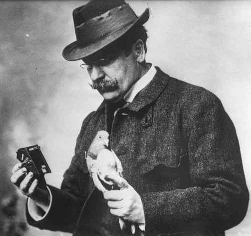
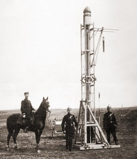

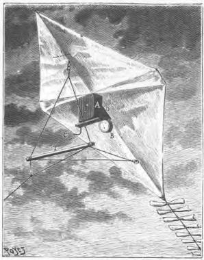

4 Early investigations A. Batut J. G.Neubronner A. Maul Using aerial kites Using Pigeons Using rockets


5 Early investigations in Russia 1886 A.M. Kovanko Saint-Petersburg S.A. Ulyanin Using box-kites Camera with a sail to lift on a kite


6 First mechanical instruments for processing K. Pulfrich E.Orel E.Orel F.V.Drobyshev Stereocomparator Stereoautograph Stereoautograph improved Stereometr


7 Investigations before N. Tesla C.F. Kettering United Kingdom Using first radiocontrolled UAV Using UAV controlled by clockwork Using reusable radio-controlled UAV


8 Investigations before LA TU-243


9 Mechanical and analytic instruments for processing Stereocomparator (Steko 1818) Rectifier FTM (SEG-4) Stereoprojector SPR Leica SD-2000


10 Investigations after 2000, UAS types Aircrafts Multicopters Helicopters


11 UAS weight, size and shape Flying wing < 10 kg Fuselage < 30 kg


12 UAS weight and shape Light 4 rotors 6 rotors 8 rotors Heavy 1 upper rotor 2 upper rotors
")


13 Ptero (Russia) Ptero E3 Ptero E Ptero G0
")


14 Finko (Russia) SUPERCAM 240 SUPERCAM SUPERCAM 350


15 Sensfly (Switzerland) Swinglet CAM ebee 2016 ebee RTK
")


16 Trimble (USA) Gatewing X100 Trimble UX Trimble UX5 HP


17 UAS reviews Aircraft UAS usage in Russia Aircraft UAS usage in other world Helicopter UAS Multicopter UAS


18 Software 1980 INPHO, Trimble, USA 2008 PhotoScan, Agisoft, Russia 1994 PHOTOMOD, Racurs, Russia 2011 ContextCapture, Bentley, USA 1995 EnsoMOSAIC Fusion, MosaicMill, Finland 2011 Pix4Dmapper, Pix4D, Switzerland 2002 Orbit UAS Mapping, Orbit GeoSpatial Technologies, Belgium 2012 APS, Menci Software, Italy 2003 Correlator3D, SimActive, Canada 2013 DroneDeploy, DroneDeploy, USA


19 Software reviews PHOTOMOD UAS INPHO UAS master PhotoScan PIX4DMapper


20 Phototriangulation Area correlators Feature Based correlators Block scheme Point cloud


21 Cameras Point and shoot camera SLR Industrial camera


22 External factors and conditions of aerial survey Humidity Temperature Wind speed during surveying


23 Technical problems with UAS data Image quality: blur, speckle, defocusing, incorrect auto exposure Consumer camera: absence of a laboratory calibration, focal-plane shutter, an incomplete set of manual settings

24 Distortion plot (typical case)

25 Problems of photogrammetric processing Incorrect aerial surveying

26 Problems of photogrammetric processing Incorrect camera operation


27 Output products Orthophotoplan DSM Processing accuracy can be up to 1-2 pix GSD


28 Output products Point cloud Vector 3D model Stereovectorization Raster 3D model
29 Trends Aerial Survey 1 Enterprise GIS system 5 2 Data processing Business Product Result introduction 4 3 Result interpretation


30 FUTURE? Сontrol and management of processing results with a full virtual human presence Full automatic batch process without human intervention


31 Special thanks N. Vorobyova, Finko, Izhevsk, Russia V. Kuznetsov, Gazprom Space Systems, Korolev, Russia V. Kurkov, MIIGiK, Moscow, Russia P. Kruglova, Photometr, Moscow, Russia G. Bozhchenko, GPSCom, Moscow, Russia D. Gryadunov, AFM-Servers, Moscow, Russia N. Volgusheva, Geoscan, S.Petersburg, Russia
32 Thank you for attention
INVESTIGATION OF PHOTOTRIANGULATION ACCURACY WITH USING OF VARIOUS TECHNIQUES LABORATORY AND FIELD CALIBRATION
 INVESTIGATION OF PHOTOTRIANGULATION ACCURACY WITH USING OF VARIOUS TECHNIQUES LABORATORY AND FIELD CALIBRATION A. G. Chibunichev 1, V. M. Kurkov 1, A. V. Smirnov 1, A. V. Govorov 1, V. A. Mikhalin 2 *
EnsoMOSAIC Aerial mapping tools
 EnsoMOSAIC Aerial mapping tools Jakarta and Kuala Lumpur, 2013 Contents MosaicMill MM Application examples Software introduction System introduction Rikola HS sensor UAV platform examples SW Syst HS UAV
22/11/2013. UAV: Overview of systems, applications and processing Kris Nackaerts, Peter Strigencz
 22/11/2013 UAV: Overview of systems, applications and processing Kris Nackaerts, Peter Strigencz Introduction» Systems» Applications» Non-imaging» Imaging» Processing, focus on photogrammetry» Use case
Deliverable 5-B: Review and Update on AURA System Requirements, Sensors, and Platforms Supplemental Report
 Deliverable 5-B: Review and Update on AURA System Requirements, Sensors, and Platforms Supplemental Report Focusing on education, research, and development of technology to sense and understand natural
Validation of the QuestUAV PPK System
 Validation of the QuestUAV PPK System 3cm in xy, 400ft, no GCPs, 100Ha, 25 flights Nigel King 1, Kerstin Traut 2, Cameron Weeks 3 & Ruairi Hardman 4 1 Director QuestUAV, 2 Data Analyst QuestUAV, 3 Production
Introduction to Photogrammetry
 Introduction to Photogrammetry Presented By: Sasanka Madawalagama Geoinformatics Center Asian Institute of Technology Thailand www.geoinfo.ait.asia Content Introduction to photogrammetry 2D to 3D Drones
Aerial efficiency, photogrammetric accuracy
 Aerial efficiency, photogrammetric accuracy Why sensefly 3 reasons to choose the ebee Plus Large coverage for optimal efficiency The ebee Plus can map more square kilometres per flight, than any drone
UAV PHOTOGRAMMETRY COMPARED TO TRADITIONAL RTK GPS SURVEYING
 UAV PHOTOGRAMMETRY COMPARED TO TRADITIONAL RTK GPS SURVEYING Brad C. Mathison and Amber Warlick March 20, 2016 Fearless Eye Inc. Kansas City, Missouri www.fearlesseye.com KEY WORDS: UAV, UAS, Accuracy
AERIAL SURVEY TEST PROJECT WITH DJI PHANTOM 3 QUADROCOPTER DRONE
 T. Jancso, P. Engler, P. Udvardy Aerial Survey Test Project with DJI Phantom 3 Quadrocopter Drone AERIAL SURVEY TEST PROJECT WITH DJI PHANTOM 3 QUADROCOPTER DRONE Tamas JANCSO, Associate Professor Phd
White Paper Reaching 1 cm (0.4 in) drone survey accuracy
 drone survey accuracy") White Paper Reaching 1 cm (0.4 in) drone survey accuracy 3x higher absolute accuracy with WingtraOne Latest tests in USA and Switzerland prove that the VTOL WingtraOne drone repeatably reaches the best-in-class
White Paper Reaching 1 cm (0.4 in) drone survey accuracy 3x higher absolute accuracy with WingtraOne Latest tests in USA and Switzerland prove that the VTOL WingtraOne drone repeatably reaches the best-in-class
White Paper Reaching 1 cm (0.4 in) drone survey accuracy
 drone survey accuracy") White Paper Reaching 1 cm (0.4 in) drone survey accuracy 3x higher absolute accuracy with WingtraOne Latest tests in the USA and Switzerland prove that the VTOL WingtraOne drone repeatedly reaches the
White Paper Reaching 1 cm (0.4 in) drone survey accuracy 3x higher absolute accuracy with WingtraOne Latest tests in the USA and Switzerland prove that the VTOL WingtraOne drone repeatedly reaches the
The survey-grade mapping drone
 The survey-grade mapping drone +380,000 +110,000 +19,000,000 FLIGHTS TO DATE FLIGHT HOURS HA COVERAGE 3 reasons to choose the ebee RTK Survey-grade accuracy Fully integrated workflow Compatible with existing
Phase One ixu-rs1000 Accuracy Assessment Report Yu. Raizman, PhaseOne.Industrial, Israel
 17 th International Scientific and Technical Conference FROM IMAGERY TO DIGITAL REALITY: ERS & Photogrammetry Phase One ixu-rs1000 Accuracy Assessment Report Yu. Raizman, PhaseOne.Industrial, Israel 1.
Unmanned Aerial Vehicle Data Acquisition for Damage Assessment in. Hurricane Events
 Unmanned Aerial Vehicle Data Acquisition for Damage Assessment in Hurricane Events Stuart M. Adams a Carol J. Friedland b and Marc L. Levitan c ABSTRACT This paper examines techniques for data collection
Experimental aerial photogrammetry with professional non metric camera Canon EOS 5D
 Experimental aerial photogrammetry with professional non metric camera Canon EOS 5D Ante Sladojević, Goran Mrvoš Galileo Geo Sustavi, Croatia 1. Introduction With this project we wanted to test professional
sensefly Camera Collection
 Camera Collection A professional sensor for every application Introducing S.O.D.A. 3D 3D mapping, redefined Image: S.O.D.A. 3D oblique image (left) merging into 3D mesh (right). Stunning digital 3D reconstructions
IMAGE ACQUISITION GUIDELINES FOR SFM
 IMAGE ACQUISITION GUIDELINES FOR SFM a.k.a. Close-range photogrammetry (as opposed to aerial/satellite photogrammetry) Basic SfM requirements (The Golden Rule): minimum of 60% overlap between the adjacent
Recent Advances in Geodata Acquisition Technologies
 ARTICLE NO INFORMATION WITHOUT DATA Recent Advances in Geodata Acquisition Technologies Today s geodata acquisition technologies combine microprocessors, computer power, solid state drives, complementary
VisionMap Sensors and Processing Roadmap
 Vilan, Gozes 51 VisionMap Sensors and Processing Roadmap YARON VILAN, ADI GOZES, Tel-Aviv ABSTRACT The A3 is a family of digital aerial mapping cameras and photogrammetric processing systems, which is
ASPECTS OF DEM GENERATION FROM UAS IMAGERY
 ASPECTS OF DEM GENERATION FROM UAS IMAGERY A. Greiwea,, R. Gehrke a,, V. Spreckels b,, A. Schlienkamp b, Department Architecture, Civil Engineering and Geomatics, Fachhochschule Frankfurt am Main, Germany
Report for 2017, Scientific Initiative. Title of project:
 Report for 2017, Scientific Initiative Title of project: DEVELOPMENT OF THE EDUCATIONAL CONTENT SMALL UAS IN CIVIL ENGINEERING APPLICATION SCENARIOS (SUAS-CAS) Principal Investigator: Roman Shults Postal
ARCHAEOLOGICAL DOCUMENTATION OF A DEFUNCT IRAQI TOWN
 ARCHAEOLOGICAL DOCUMENTATION OF A DEFUNCT IRAQI TOWN J. Šedina a, K. Pavelka a, E. Housarová a a Czech Technical University in Prague, Faculty of Civil Engineering, Department of Geomatics, Thakurova 7,
Overview. Objectives. The ultimate goal is to compare the performance that different equipment offers us in a photogrammetric flight.
 Overview At present, one of the most commonly used technique for topographic surveys is aerial photogrammetry. This technique uses aerial images to determine the geometric properties of objects and spatial
HIGH RESOLUTION COLOR IMAGERY FOR ORTHOMAPS AND REMOTE SENSING. Author: Peter Fricker Director Product Management Image Sensors
 HIGH RESOLUTION COLOR IMAGERY FOR ORTHOMAPS AND REMOTE SENSING Author: Peter Fricker Director Product Management Image Sensors Co-Author: Tauno Saks Product Manager Airborne Data Acquisition Leica Geosystems
Racurs Co presentation
 VIIth International Scientific and Technical Conference From Imagery to Map: Digital Photogrammetric Technologies Racurs Co presentation Dr. Victor Adrov, Managing Director, Racurs, Moscow RACURS & PHOTOMOD
Phase One 190MP Aerial System
 White Paper Phase One 190MP Aerial System Introduction Phase One Industrial s 100MP medium format aerial camera systems have earned a worldwide reputation for its high performance. They are commonly used
Capture the invisible
 Capture the invisible A Capture the invisible The Sequoia multispectral sensor captures both visible and invisible images, providing calibrated data to optimally monitor the health and vigor of your crops.
UAV Technologies for 3D Mapping. Rolf Schaeppi Director Geospatial Solutions APAC / India
 UAV Technologies for 3D Mapping Rolf Schaeppi Director Geospatial Solutions APAC / India Some main application areas? Market situation Analyst statements billion dollars 7,3 defense market 2,5 civil market
RPAS Photogrammetric Mapping Workflow and Accuracy
 RPAS Photogrammetric Mapping Workflow and Accuracy Dr Yincai Zhou & Dr Craig Roberts Surveying and Geospatial Engineering School of Civil and Environmental Engineering, UNSW Background RPAS category and
Technical Evaluation of Khartoum State Mapping Project
 Technical Evaluation of Khartoum State Mapping Project Nagi Zomrawi 1 and Mohammed Fator 2 1 School of Surveying Engineering, Collage of Engineering, Sudan University of Science and Technology, Khartoum,
Assessment of Unmanned Aerial Vehicle for Management of Disaster Information
 Journal of the Korea Academia-Industrial cooperation Society Vol. 16, No. 1 pp. 697-702, 2015 http://dx.doi.org/10.5762/kais.2015.16.1.697 ISSN 1975-4701 / eissn 2288-4688 Assessment of Unmanned Aerial
Assessing the Accuracy of Ortho-image using Photogrammetric Unmanned Aerial System
 Assessing the Accuracy of Ortho-image using Photogrammetric Unmanned Aerial System H. H. Jeong a, J. W. Park a, J. S. Kim a, C. U. Choi a, * a Dept. of Spatial Information Engineering, Pukyong National
Aerial Triangulation Radiometry Essentials Dense Matching Ortho Generation
 Radiometry Aerial Triangulation Essentials Dense Matching Ortho Generation Highly advanced photogrammetric workflow system for UltraCam images. Microsoft UltraMap is a state-of-the-art, end-to-end, complete
UAS Photogrammetry Best Practices
 UAS Photogrammetry Best Practices Pennsylvania Society of Land Surveyors January 15, 2019 Bryan Baker Certified Mapping Scientist (UAS) Bryan Baker UAS Sales Manager Leica Geosystems Reality Capture Team
PRELIMINARY RESULTS FROM THE PORTABLE IMAGERY QUALITY ASSESSMENT TEST FIELD (PIQuAT) OF UAV IMAGERY FOR IMAGERY RECONNAISSANCE PURPOSES
 OF UAV IMAGERY FOR IMAGERY RECONNAISSANCE PURPOSES") PRELIMINARY RESULTS FROM THE PORTABLE IMAGERY QUALITY ASSESSMENT TEST FIELD (PIQuAT) OF UAV IMAGERY FOR IMAGERY RECONNAISSANCE PURPOSES R. Dabrowski a, A. Orych a, A. Jenerowicz a, P. Walczykowski a, a
PRELIMINARY RESULTS FROM THE PORTABLE IMAGERY QUALITY ASSESSMENT TEST FIELD (PIQuAT) OF UAV IMAGERY FOR IMAGERY RECONNAISSANCE PURPOSES R. Dabrowski a, A. Orych a, A. Jenerowicz a, P. Walczykowski a, a
RESEARCH ON LOW ALTITUDE IMAGE ACQUISITION SYSTEM
 RESEARCH ON LOW ALTITUDE IMAGE ACQUISITION SYSTEM 1, Hongxia Cui, Zongjian Lin, Jinsong Zhang 3,* 1 Department of Information Science and Engineering, University of Bohai, Jinzhou, Liaoning Province,11,
Airborne or Spaceborne Images for Topographic Mapping?
 Advances in Geosciences Konstantinos Perakis, Editor EARSeL, 2012 Airborne or Spaceborne Images for Topographic Mapping? Karsten Jacobsen Leibniz University Hannover, Institute of Photogrammetry and Geoinformation,
Sample Copy. Not For Distribution.
 Photogrammetry, GIS & Remote Sensing Quick Reference Book i EDUCREATION PUBLISHING Shubham Vihar, Mangla, Bilaspur, Chhattisgarh - 495001 Website: www.educreation.in Copyright, 2017, S.S. Manugula, V.
0. Introduction 2 hours
 Lecture 0-1 _ February 2003 0. Introduction 2 hours History (analog, analytical, digital) Image information (physical, geometrical, semantic Literature Organizations Part 1 of 2 0.1. Definitions Photogrammetry
Five Sensors, One Day: Unmanned vs. Manned Logistics and Accuracy
 Five Sensors, One Day: Unmanned vs. Manned Logistics and Accuracy ASPRS UAS Mapping Technical Symposium Sept 13 th, 2016 Presenter: David Day, CP, GISP Keystone Aerial Surveys, Inc. Summary of activities
Muhd. Safarudin Chek Mat #1,Nazirah Md Tarmizi #2, Mokhtar Azizi Mohd Din *3, Abdul Manan Samad #2
 2014 IEEE 4th International Conference on System Engineering and Technology (ICSET) November 24-25, 2014 Bandung - Indonesia Application of UAiCs for Quarry Determination and Spatial Analysis Muhd. Safarudin
Vexcel Imaging GmbH Innovating in Photogrammetry: UltraCamXp, UltraCamLp and UltraMap
 Photogrammetric Week '09 Dieter Fritsch (Ed.) Wichmann Verlag, Heidelberg, 2009 Wiechert, Gruber 27 Vexcel Imaging GmbH Innovating in Photogrammetry: UltraCamXp, UltraCamLp and UltraMap ALEXANDER WIECHERT,
2019 NYSAPLS Conf> Fundamentals of Photogrammetry for Land Surveyors
 2019 NYSAPLS Conf> Fundamentals of Photogrammetry for Land Surveyors George Southard GSKS Associates LLC Introduction George Southard: Master s Degree in Photogrammetry and Cartography 40 years working
KEY WORDS: Animation, Architecture, Image Rectification, Multi-Media, Texture Mapping, Visualization
 AUTOMATED PROCESSING OF DIGITAL IMAGE DATA IN ARCHITECTURAL SURVEYING Günter Pomaska Prof. Dr.-Ing., Faculty of Architecture and Civil Engineering FH Bielefeld, University of Applied Sciences Artilleriestr.
RACURS Co. PHOTOMOD Digital photogrammetric technologies
 RACURS Co. PHOTOMOD Digital photogrammetric technologies RACURS & PHOTOMOD Racurs company's business mission is to provide the world-wide geospatial community with advanced and cost-effective digital photogrammetry
Economic Considerations for Photogrammetric Mapping
 Economic Considerations for Photogrammetric Mapping Paper to the RACURS Conference 2008 Porec, Croatia Monday, September 15, 2008 by Gottfried Konecny, Emeritus Professor, Leibniz University Hannover,
Factors that affect the accuracy of UAS surveys
 Factors that affect the accuracy of UAS surveys Dr. Dimitrios Bolkas; dxb80@psu.edu Department of Surveying Engineering, Pennsylvania State University, Wilkes-Barre Campus PSLS Surveyor s Conference Hershey,
2/9/2018. Fun with Drones Raymond J. Hintz, PLS, PhD University of Maine
 Fun with Drones Raymond J. Hintz, PLS, PhD University of Maine Raymond.hintz@umit.maine.edu 2 types (1)Fixed wing (airplane) -can be cheaper -can be faster and last longer on a battery -Need a take-off
Fun with Drones Raymond J. Hintz, PLS, PhD University of Maine
 Fun with Drones Raymond J. Hintz, PLS, PhD University of Maine Raymond.hintz@umit.maine.edu 2 types (1)Fixed wing (airplane) -can be cheaper -can be faster and last longer on a battery -Need a take-off
HISTORY OF REMOTE SENSING
 HISTORY OF REMOTE SENSING IMPORTANT PERIODS The beginning: photography and flight (1858-1918) Rapid developments in photogrammetry (1918-1939) Military imperatives (1939-1945) Cold wars and environmental
accuracy. You even hear the terms subcentimeter or even millimeter absolute accuracy during some of these
 Question: I would like to get your expert opinion on a dataset I just received. It is UAS-based imagery collected to produce a 50cm Digital Elevation Models (DEM) and 5cm resolution true color orthos.
PNC Deployment and integration of cost-effective, high spatial resolution, remotely sensed data for the Australian forestry industry
 PNC326-1314 Deployment and integration of cost-effective, high spatial resolution, remotely sensed data for the Australian forestry industry PHOTOGRAMMETRY FOR FOREST INVENTORY Planning Guidelines Osborn
MEDIUM FORMAT CAMERA EVALUATION BASED ON THE LATEST PHASE ONE TECHNOLOGY
 MEDIUM FORMAT CAMERA EVALUATION BASED ON THE LATEST PHASE ONE TECHNOLOGY T.Tölg a, G. Kemper b, D. Kalinski c a Phase One / Germany tto@phaseone.com b GGS GmbH, Speyer / Germany kemper@ggs-speyer.de c
Digital airborne cameras Status & future
 Institut für Photogrammetrie ifp Digital airborne cameras Status & future Michael Cramer Institute for Photogrammetry, Univ. of Stuttgart Geschwister-Scholl-Str.24, D-70174 Stuttgart Tel: + 49 711 121
Lecture 7. Leica ADS 80 Camera System and Imagery. Ontario ADS 80 FRI Imagery. NRMT 2270, Photogrammetry/Remote Sensing
 NRMT 2270, Photogrammetry/Remote Sensing Lecture 7 Leica ADS 80 Camera System and Imagery. Ontario ADS 80 FRI Imagery. Tomislav Sapic GIS Technologist Faculty of Natural Resources Management Lakehead University
Structure from Motion (SfM) Photogrammetry Field Methods Manual for Students
 Photogrammetry Field Methods Manual for Students") Structure from Motion (SfM) Photogrammetry Field Methods Manual for Students Written by Katherine Shervais (UNAVCO) Introduction to SfM for Field Education The purpose of the Analyzing High Resolution
Structure from Motion (SfM) Photogrammetry Field Methods Manual for Students Written by Katherine Shervais (UNAVCO) Introduction to SfM for Field Education The purpose of the Analyzing High Resolution
Photomod Lite Contest 2013 Creating vegetation map using UAV at Seaside Palouki forest (Greece) by Apostolos Nteris
 by Apostolos Nteris") P r o j e c t I n f o r m a t i o n Title: Creating vegetation map using UAV at seaside Palouki forest (Greece) Author: Apostolos Nteris, Surveyor engineer OLYZON consulting - Trikala Greece Contact: Apostolos
P r o j e c t I n f o r m a t i o n Title: Creating vegetation map using UAV at seaside Palouki forest (Greece) Author: Apostolos Nteris, Surveyor engineer OLYZON consulting - Trikala Greece Contact: Apostolos
** KEYSTONE AERIAL SURVEYS R. David Day, Wesley Weaver **
 AN ACCURACY ANALYSIS OF LARGE RESOLUTION IMAGES CAPTURED WITH THE NIKON D810 DIGITAL CAMERA SYSTEM Ricardo M. Passini * * ricardopassini2012@outlook.com ** KEYSTONE AERIAL SURVEYS R. David Day, Wesley
How Farmer Can Utilize Drone Mapping?
 Presented at the FIG Working Week 2017, May 29 - June 2, 2017 in Helsinki, Finland How Farmer Can Utilize Drone Mapping? National Land Survey of Finland Finnish Geospatial Research Institute Roope Näsi,
COMPETITOR OR COMPANION TO LASER SCANNING?
 PHOTOGRAMMETRY: COMPETITOR OR COMPANION TO LASER SCANNING? Eugene Liscio, P. Eng., President AI2-3D David Boardman, CEO of URC Ventures Carlos Gregory Velazquez, CEO of Epic Scan Ltd. Sponsored by TABLE
AUTOMATED PROCESSING OF DIGITAL IMAGE DATA IN ARCHITECTURAL SURVEYING
 International Archives of Photogrammetry and Remote Sensing. Vol. XXXII, Part 5. Hakodate 1998 AUTOMATED PROCESSING OF DIGITAL IMAGE DATA IN ARCHITECTURAL SURVEYING Gunter Pomaska Prof. Dr.-lng., Faculty
ACCURACY ASSESSMENT OF DIRECT GEOREFERENCING FOR PHOTOGRAMMETRIC APPLICATIONS ON SMALL UNMANNED AERIAL PLATFORMS
 ACCURACY ASSESSMENT OF DIRECT GEOREFERENCING FOR PHOTOGRAMMETRIC APPLICATIONS ON SMALL UNMANNED AERIAL PLATFORMS O. Mian a, J. Lutes a, G. Lipa a, J. J. Hutton a, E. Gavelle b S. Borghini c * a Applanix
VisionMap A3 Edge A Single Camera for Multiple Solutions
 Photogrammetric Week '15 Dieter Fritsch (Ed.) Wichmann/VDE Verlag, Belin & Offenbach, 2015 Raizman, Gozes 57 VisionMap A3 Edge A Single Camera for Multiple Solutions Yuri Raizman, Adi Gozes, Tel-Aviv ABSTRACT
High Resolution Sensor Test Comparison with SPOT, KFA1000, KVR1000, IRS-1C and DPA in Lower Saxony
 High Resolution Sensor Test Comparison with SPOT, KFA1000, KVR1000, IRS-1C and DPA in Lower Saxony K. Jacobsen, G. Konecny, H. Wegmann Abstract The Institute for Photogrammetry and Engineering Surveys
Lesson 4: Photogrammetry
 This work by the National Information Security and Geospatial Technologies Consortium (NISGTC), and except where otherwise Development was funded by the Department of Labor (DOL) Trade Adjustment Assistance
The survey-grade mapping drone
 The survey-grade mapping drone 3 reasons to choose the ebee RTK 01. Survey-grade accuracy Absolute orthomosaic / Digital Elevation Model accuracy of down to 3 cm (1.2 in) without the need for GCPs meaning
The Hyperspectral UAV (HyUAV) a novel UAV-based spectroscopy tool for environmental monitoring
 a novel UAV-based spectroscopy tool for environmental monitoring") The Hyperspectral UAV (HyUAV) a novel UAV-based spectroscopy tool for environmental monitoring R. Garzonio 1, S. Cogliati 1, B. Di Mauro 1, A. Zanin 2, B. Tattarletti 2, F. Zacchello 2, P. Marras 2 and
The Hyperspectral UAV (HyUAV) a novel UAV-based spectroscopy tool for environmental monitoring R. Garzonio 1, S. Cogliati 1, B. Di Mauro 1, A. Zanin 2, B. Tattarletti 2, F. Zacchello 2, P. Marras 2 and
Coastal Imaging of Morphology
 Coastal Imaging of Morphology Katherine Brodie 1, Margaret Palmsten 2, Jenna Long 3, and Brittany Bruder 1 1 U.S. Army Engineer Research and Development Center, Coastal and Hydraulics Laboratory, Duck,
HD aerial video for coastal zone ecological mapping
 HD aerial video for coastal zone ecological mapping Albert K. Chong University of Otago, Dunedin, New Zealand Phone: +64 3 479-7587 Fax: +64 3 479-7586 Email: albert.chong@surveying.otago.ac.nz Presented
Z/I Imaging: A New System Provider for Photogrammetry and GIS
 Spiller 35 Z/I Imaging: A New System Provider for Photogrammetry and GIS RUDOLF H. S PILLER, Oberkochen ABSTRACT The world of photogrammetry has changed dramatically. This could be a short description
APPLICATION OF ANALYTICAL AND DIGITAL PHOTOGRAM M ETRY METHODS FO R FO RECASTING VISTULA RIVER FLOODS.
 Polskie Towarzystwo Fotogrametrii i Teledetekcji Sekcja Fotogrametrii i Teledetekcji Komitetu Geodezji PAN Komisja Geoinformatyki PAU Zakład Fotogrametrii i Informatyki Teledetekcyjnej AGH Archiwum Fotogrametrii,
Customer Showcase > Defense and Intelligence
 Customer Showcase Skyline TerraExplorer is a critical visualization technology broadly deployed in defense and intelligence, public safety and security, 3D geoportals, and urban planning markets. It fuses
USE OF IMPROVISED REMOTELY SENSED DATA FROM UAV FOR GIS AND MAPPING, A CASE STUDY OF GOMA CITY, DR CONGO
 USE OF IMPROVISED REMOTELY SENSED DATA FROM UAV FOR GIS AND MAPPING, A CASE STUDY OF GOMA CITY, DR CONGO Cung Chin Thang United Nations Global Support Center, Brindisi, Italy, Email: thang@un.org KEY WORDS:
From Photos to Models
 From Photos to Models Strategies for using digital photogrammetry in your project Adam Barnes Katie Simon Adam Wiewel What is Photogrammetry? The art, science and technology of obtaining reliable information
Visual inspection strategies for large bridges using Unmanned Aerial Vehicles (UAV)
") Visual inspection strategies for large bridges using Unmanned Aerial Vehicles (UAV) Norman Hallermann & Guido Morgenthal Bauhaus-Universität Weimar, Chair of Modeling and Simulation of Structures, Weimar,
Visual inspection strategies for large bridges using Unmanned Aerial Vehicles (UAV) Norman Hallermann & Guido Morgenthal Bauhaus-Universität Weimar, Chair of Modeling and Simulation of Structures, Weimar,
An Introduction to Geomatics. Prepared by: Dr. Maher A. El-Hallaq خاص بطلبة مساق مقدمة في علم. Associate Professor of Surveying IUG
 An Introduction to Geomatics خاص بطلبة مساق مقدمة في علم الجيوماتكس Prepared by: Dr. Maher A. El-Hallaq Associate Professor of Surveying IUG 1 Airborne Imagery Dr. Maher A. El-Hallaq Associate Professor
MULTISPECTRAL AGRICULTURAL ASSESSMENT. Normalized Difference Vegetation Index. Federal Robotics INSPECTION & DOCUMENTATION
 MULTISPECTRAL AGRICULTURAL ASSESSMENT Normalized Difference Vegetation Index INSPECTION & DOCUMENTATION Federal Robotics Clearwater Dr. Amherst, New York 14228 716-221-4181 Sales@FedRobot.com www.fedrobot.com
REMOTE SENSING WITH DRONES. YNCenter Video Conference Chang Cao
 REMOTE SENSING WITH DRONES YNCenter Video Conference Chang Cao 08-28-2015 28 August 2015 2 Drone remote sensing It was first utilized in military context and has been given great attention in civil use
ContextCapture Quick guide for photo acquisition
 ContextCapture Quick guide for photo acquisition ContextCapture is automatically turning photos into 3D models, meaning that the quality of the input dataset has a deep impact on the output 3D model which
Drones and Ham Radio. Bob Schatzman KD9AAD
 Drones and Ham Radio Bob Schatzman KD9AAD Not Your Childhood RC Toy! Highly Accurate GPS receiver! Magnetic Compass! R/C Transmitter/Receiver! Accelerometers/Gyros! HDTV & HQ Still Camera on a Smart Gimbal!
ScienceDirect. The potential of UAV-based remote sensing for supporting precision agriculture in Indonesia
 Available online at www.sciencedirect.com ScienceDirect Procedia Environmental Sciences 24 (2015 ) 245 253 The 1st International Symposium on LAPAN-IPB Satellite for Food Security and Environmental Monitoring
PHOTOGRAMMETRIC RESECTION DIFFERENCES BASED ON LABORATORY vs. OPERATIONAL CALIBRATIONS
 PHOTOGRAMMETRIC RESECTION DIFFERENCES BASED ON LABORATORY vs. OPERATIONAL CALIBRATIONS Dean C. MERCHANT Topo Photo Inc. Columbus, Ohio USA merchant.2@osu.edu KEY WORDS: Photogrammetry, Calibration, GPS,
Using Low Cost DeskTop Publishing (DTP) Scanners for Aerial Photogrammetry
 Scanners for Aerial Photogrammetry") Journal of Geosciences and Geomatics, 21, Vol. 2, No., 17- Available online at http://pubs.sciepub.com/jgg/2//5 Science and Education Publishing DOI:1.12691/jgg-2--5 Using Low Cost DeskTop Publishing (DTP)
Journal of Geosciences and Geomatics, 21, Vol. 2, No., 17- Available online at http://pubs.sciepub.com/jgg/2//5 Science and Education Publishing DOI:1.12691/jgg-2--5 Using Low Cost DeskTop Publishing (DTP)
Structure from Motion Introductory Guide
 Katherine Shervais (UNAVCO) This guide is intended as a resource for using Structure from Motion in research applications. It does not detail the algorithms or mathematical background of the methodology,
AIRPORT MAPPING JUNE 2016 EXPLORING UAS EFFECTIVENESS GEOSPATIAL SLAM TECHNOLOGY FEMA S ROMANCE WITH LIDAR VOLUME 6 ISSUE 4
 VOLUME 6 ISSUE 4 JUNE 2016 AIRPORT MAPPING 18 EXPLORING UAS EFFECTIVENESS 29 GEOSPATIAL SLAM TECHNOLOGY 36 FEMA S ROMANCE WITH LIDAR Nearly 2,000 U.S. landfill facilities stand to gain from cost-effective
EXAMPLES OF TOPOGRAPHIC MAPS PRODUCED FROM SPACE AND ACHIEVED ACCURACY CARAVAN Workshop on Mapping from Space, Phnom Penh, June 2000
 EXAMPLES OF TOPOGRAPHIC MAPS PRODUCED FROM SPACE AND ACHIEVED ACCURACY CARAVAN Workshop on Mapping from Space, Phnom Penh, June 2000 Jacobsen, Karsten University of Hannover Email: karsten@ipi.uni-hannover.de
UAS BASED TREE SPECIES IDENTIFICATION USING THE NOVEL FPI BASED HYPERSPECTRAL CAMERAS IN VISIBLE, NIR AND SWIR SPECTRAL RANGES
 UAS BASED TREE SPECIES IDENTIFICATION USING THE NOVEL FPI BASED HYPERSPECTRAL CAMERAS IN VISIBLE, NIR AND SWIR SPECTRAL RANGES R. Näsi a, *, E. Honkavaara a, S. Tuominen b, H. Saari c, I. Pölönen d, T.
14th Congress of the International Society of Photogrammetry Hamburg Commission II. Presented Paper STEREOMARKING INSTRUMENTS DSI-T AND NT
 14th Congress of the International Society of Photogrammetry Hamburg 1980 Commission II Presented Paper STEREOMARKING INSTRUMENTS DSI-T AND NT Iljin L.B. TsNIIGAiK, Moscow, USSR ABSTRACT: Efficient use
The New Rig Camera Process in TNTmips Pro 2018
 The New Rig Camera Process in TNTmips Pro 2018 Jack Paris, Ph.D. Paris Geospatial, LLC, 3017 Park Ave., Clovis, CA 93611, 559-291-2796, jparis37@msn.com Kinds of Digital Cameras for Drones Two kinds of
Airborne Thermal Survey
 Airborne Thermal Survey Geotechnologies provides airborne thermal survey including producing of digital map layers for customer GIS system. We also provide full software support of a survey process. Geotechnologies
DSW700 System Description
 DSW700 Technical Details Overview Softcopy photogrammetry work, stereo-compilation, and ultimately, orthophotos can only be as accurate as the source imagery. Working in a digital photogrammetry environment
Chapters 1 & 2. Definitions and applications Conceptual basis of photogrammetric processing
 Chapters 1 & 2 Chapter 1: Photogrammetry Definitions and applications Conceptual basis of photogrammetric processing Transition from two-dimensional imagery to three-dimensional information Automation
Flood modelling and management. Glasgow University. 8 September Paul Shaw - GeoVision
 Flood modelling and management Glasgow University 8 September 2004 Paul Shaw - GeoVision How important are heights in flood modelling? Comparison of data collection technologies GPS - Global Positioning
Outline Remote Sensing Defined Resolution Electromagnetic Energy (EMR) Types Interpretation Applications 2
 Types Interpretation Applications 2") Introduction to Remote Sensing 1 Outline Remote Sensing Defined Resolution Electromagnetic Energy (EMR) Types Interpretation Applications 2 Remote Sensing Defined Remote Sensing is: The art and science
Introduction to Remote Sensing 1 Outline Remote Sensing Defined Resolution Electromagnetic Energy (EMR) Types Interpretation Applications 2 Remote Sensing Defined Remote Sensing is: The art and science
Processing of stereo scanner: from stereo plotter to pixel factory
 Photogrammetric Week '03 Dieter Fritsch (Ed.) Wichmann Verlag, Heidelberg, 2003 Bignone 141 Processing of stereo scanner: from stereo plotter to pixel factory FRANK BIGNONE, ISTAR, France ABSTRACT With
VERIFICATION OF POTENCY OF AERIAL DIGITAL OBLIQUE CAMERAS FOR AERIAL PHOTOGRAMMETRY IN JAPAN
 VERIFICATION OF POTENCY OF AERIAL DIGITAL OBLIQUE CAMERAS FOR AERIAL PHOTOGRAMMETRY IN JAPAN Ryuji. Nakada a, *, Masanori. Takigawa a, Tomowo. Ohga a, Noritsuna. Fujii a a Asia Air Survey Co. Ltd., Kawasaki
RM-6 AutoScanner A WE HR L I /G EO SYS TE M I NS T R UMENT
 RM-6 AutoScanner A WEHRLI/GEOSYSTEM I NSTRUMENT Photogrammetric Scanning Reel Features Roll film or individual frame (cut sheet) scanning Color, Black/White or Infrared film Glass plates Motorized spools
Aerial photography: Principles. Frame capture sensors: Analog film and digital cameras
 Aerial photography: Principles Frame capture sensors: Analog film and digital cameras Overview Introduction Frame vs scanning sensors Cameras (film and digital) Photogrammetry Orthophotos Air photos are
Baldwin and Mobile Counties, AL Orthoimagery Project Report. Submitted: March 23, 2016
 2015 Orthoimagery Project Report Submitted: Prepared by: Quantum Spatial, Inc 523 Wellington Way, Suite 375 Lexington, KY 40503 859-277-8700 Page i of iii Contents Project Report 1. Summary / Scope...