From Photos to Models
|
|
|
- Avice Henderson
- 6 years ago
- Views:
Transcription
1 From Photos to Models Strategies for using digital photogrammetry in your project Adam Barnes Katie Simon Adam Wiewel

2 What is Photogrammetry? The art, science and technology of obtaining reliable information about physical objects and the environment through the process of recording, measuring and interpreting photographic images and patterns of electromagnetic radiant imagery and other phenomena. (American Society for Photogrammetry and Remote Sensing 1980)

3 What can Photogrammetry do for my project? Close-range DSLR Scale Aerial Photo Scale Amphora stamps from Ancient Athenian Agora (with American School of Classical Studies at Athens DEM generated from historic images of Cusco, Peru Cotsen Institute/UCLA Geomatics Field school 2009)
4 What can Photogrammetry do for my project? Documentation Visualization Metric Analysis Geometric Comparison Reconstruction from Historic Photos Change Detection Prospection
5 A LITTLE BACKGROUND


6 In the Beginning From late 1800s and early 1900s, primarily aerial Photogrammetry Originally done via optical-mechanical systems


7 Digital Photogrammetry Beginnings In 1990s vendors developed computer based systems In mid 1990s these cost north of $250,000! Use of very expensive metric cameras $10K + Complex processes Required technical staff and equipment No room for human error


8 Automated Close-Range Photogrammetry (CRP) Photogrammetry for the masses The generation of 3D models from 2D images using the SIFT (scale-invariant feature transform) algorithm to automate the workflow of feature matching between multiple photos that s required in photogrammetry.

9 How does automated CRP it work?


10 Evolution of Automated CRP Late 1800s, Early 1900s Photogrammetry Nonlinear Iterative Highly Accurate Historically manual Fast Linear Approximate Generally Automated Mid 1900s Computer Vision/SfM Bundle Adjustment 2004 SIFT algorithm Automated Close-Range Photogrammetry


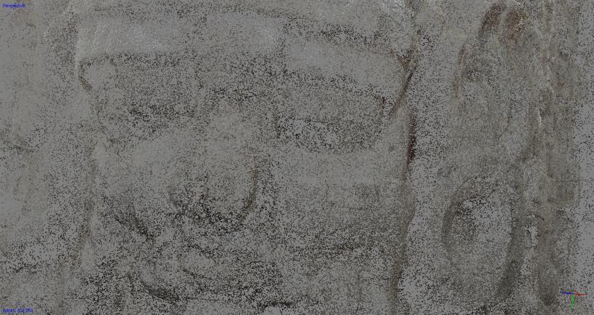
11 Data collection: Multiple overlapping photos from different locations Automated feature matching: Over 2000 matches and nearly 1000 incorrect matches Derived interpolated surface geometry (mesh)
12 Automated Close-Range Photogrammetry Many Parameters and Processing Choices INPUT Collect Images Derive Point Clouds Image Preparation Loop Closing Bundle Adjustment Transformation to absolute coordinates Keypoint Detection Keypoint Matching Images left? No images left? Image Rectification Dense Depth Estimation Pose Estimation using Epiloar Geometry 3D Point Triangulation First two images? Remaining images? Pose estimation using POSIT algorithm 3D point triangulation Triangle Mesh Generation Model Fusion OUTPUT

13

14
15 Project Planning Define project goals Choose suitable equipment Computer, camera, lens, tripod? Complete project metadata (our suggested metadata forms available at gmv.cast.uark.edu) Camera calibration (automated in some software) Acquire Images Be systematic Record metadata Acquire External Control (optional) GPS, LiDAR, Total Station, existing GIS data Record metadata Process/Enhance Digital Images Convert raw to tiff (uncompressed jpeg) White balance Color matching Photogrammetric software processing Create and Export Deliverables
16 IMAGE ACQUISITION
17 Things to avoid Very dark surfaces Reflective surfaces Transparent surfaces (including water) Uniform textures and solid color surfaces Moving light sources/shadows Capturing your own shadow


18 What s necessary Contiguous photos with 80% overlap


, 1525 bad")

19 What s necessary Contiguous photos with 80% overlap Good overlap: 3967 good matches (blue), 1525 bad (red) Bad overlap: 16 good matches, 142 bad
20 What s necessary Contiguous photos with 80% overlap Move camera between shots
21 What s necessary Contiguous photos with 80% overlap Move camera between shots


22 What s necessary Contiguous photos with 80% overlap Move camera between shots Minimize/eliminate moving shadows Static light source Diffuse light

23 What s necessary Contiguous photos with 80% overlap Move camera between shots Minimize/eliminate moving shadows Static light source Diffuse light 5+ megapixel camera Wider lenses (50 mm or less) Maximize depth of field Aperture between F8 and F16 This varies with lens Tip: use aperture priority mode Include scale in a few extra photos or precisely measure and record a few features Color checker
24 Will my camera work? Metric vs Non-Metric A metric camera is a general term applicable to a camera which has been designed as a survey camera and possessing a well defined inner orientation. That is a camera possessing a good lens with a wide field of view and small distortion, a calibrated principal distance and in which the position of the principal point can be located in the image plane by reference to fiducial marks. The picture format is normally fairly large and the film is flattened in the focal plane at the instant of photography. Cameras not possessing these characteristics can be defined as simple or non metric Cameras. Adams, L.P., The Use of Non Metric Cameras in Short Range Photogrammetry. 14th Congress of the International Society for Photogrammetry, Commission V, Hamburg, Germany. It is around this time (1980) that non-metric cameras were established as a suitable tool for close-range photogrammetry, and that the accuracy of projects using non-metric cameras could equal those using metric cameras. Karara, H.M., and W. Faig, An Expose on Photographic Data Aquisition Systems in Close-Range Photogrammetry. 14th Congress of the International Society for Photogrammetry, Commission V, Hamburg, Germany.
25 Will my camera work? - Things to consider: - Image resolution (pixel count) More is typically better, but only if the sensor size is reasonable. - Sensor size Larger is typically better, but with good conditions a small sensor can do well. Ideally, your camera sensor will be APS-C (crop factor of 1.6) or bigger, and be 8 MP or higher. - Access to camera parameters Manually setting the aperture size, shutter speed, and ISO will allow you to control the depth of field and exposure of each image. By maximizing the depth of field, objects both near and far will be sharp and can be more accurately measured. - Focus of lens Ideally you can set the focus to manual, so the camera does not autofocus for each image. - Image format can you save images to TIFF or uncompressed JPEG format? - Use with accessories can the camera be mounted to a tripod? Remote shutter release? Flash/strobe compatible? - Lens distortion wide angle lenses are best. For full frame DSLR cameras, a 20-28mm fixed focal length lens is ideal. For cropped sensors you ll need to calculate the equivalent (e.g. a crop factor of 1.6 would need an 18mm lens (1.6 * 18 = 28)). Fish eye lenses (e.g. GoPro) have too much distortion. - Rolling shutters inexpensive cameras (e.g. iphone camera) can have an electronic rolling shutter, meaning the sensor is not globally exposed. Rather, each line is exposed consecutively from one side to the other. This type of exposure is not modeled by most photogrammetric software and will normally fail. - EXIF information Though not 100% necessary if you already know the specs of your camera (or have your camera calibrated), EXIF data should be preserved. This is used by most photogrammetric software to extract initial camera parameters (i.e. focal length, sensor width/height) and GPS coordinates if available. - Digital and/or optical zoom Do not use digital zoom. If your camera has an optical zoom, set this at the beginning of the project and do not adjust. Literally tapping the zoom ring of the lens is a good idea. - Image stabilization Turn off any image stabilization. If your camera has this feature and you cannot turn it off, you can likely expect poor results.
26 Format Size - Large format - Digital e.g.: Intergraph DMC II250, x pixels (250 MP), 112mm focal length - 2.5cm GSD@500m (392x366m) - Analogue camera parameters: - Square sensor, 9 x 9 inch, 150mm or 300mm focal length - Typically 100 line pairs/mm optical resolution (2540 line pairs/inch) - Scanned at 12.5 microns (2100 dpi), will produce a 330 MP image. At 20 microns, will produce a 130 MP image. - Leica ADS40, Vexcel UltraCam - Medium format - Intergraph RMK D, 5760 x 6400 pixels (37 MP), 45mm focal length - 8cm GSD@500m (460x512m) - Small format - All full frame, 35mm equivalent DSLRs (Canon 5D 22MP, Nikon D800 36MP) - 6.5cm GSD@500m (365x243m) - All cropped frame DSLRs (Canon APS-C, Nikon DX) - Also all point-and-shoot or compact cameras

27 Format Size

28 Final model resolution A function of pixel size, lens focal length, working distance
29 DATA PROCESSING

30 Basic processing pipeline Take Photographs Align photos and generate sparse point cloud Generate dense point cloud Interpolate surface geometry to create a mesh Derive Textures Associate Textures with Geometry Scale and geo-reference the model Contextualize and Annotate the Model

31 Pre-processing color match and white balance
 between photos 186 photos from Canon 5D")
32 Initial photo alignment Match points (SIFT features) between photos 186 photos from Canon 5D MarkII

33 Sparse point cloud 3D reconstruction from match points

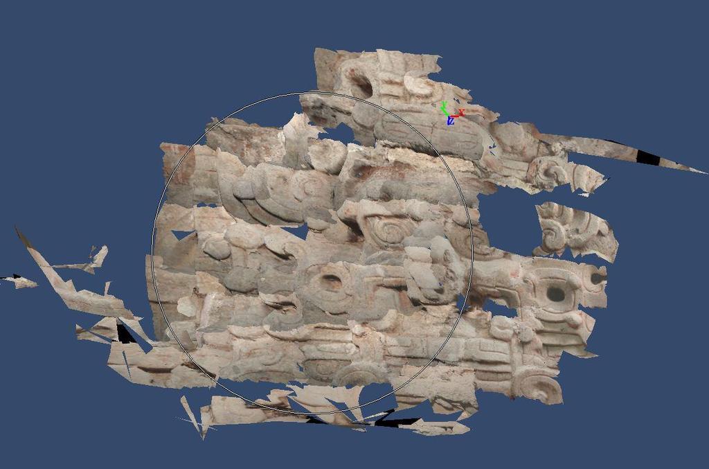
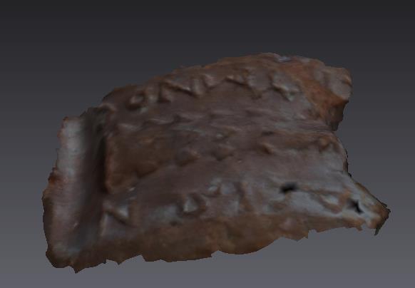
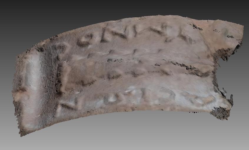
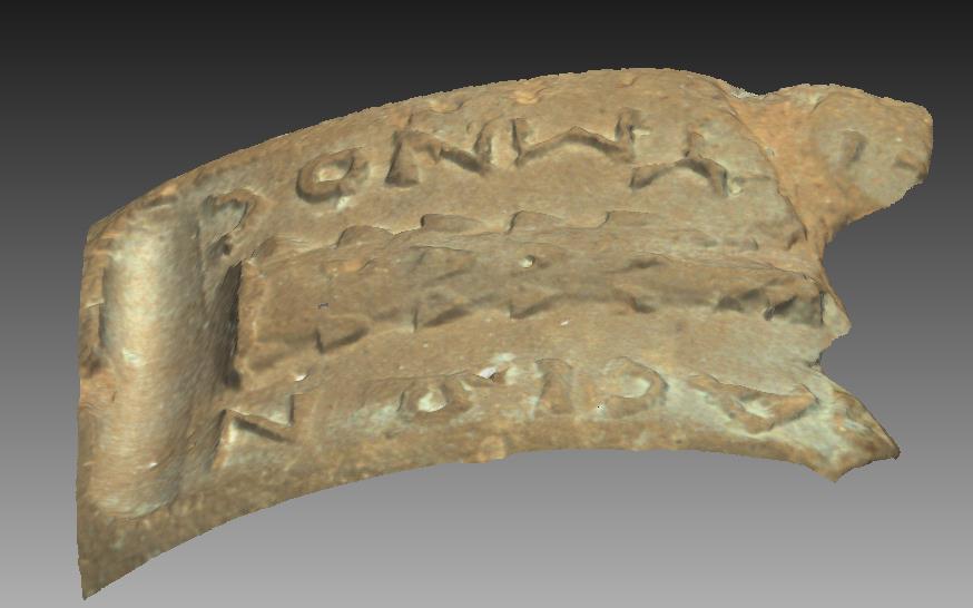
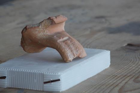
34 Dense point cloud Reconstruction from sparse point cloud 801,883 points
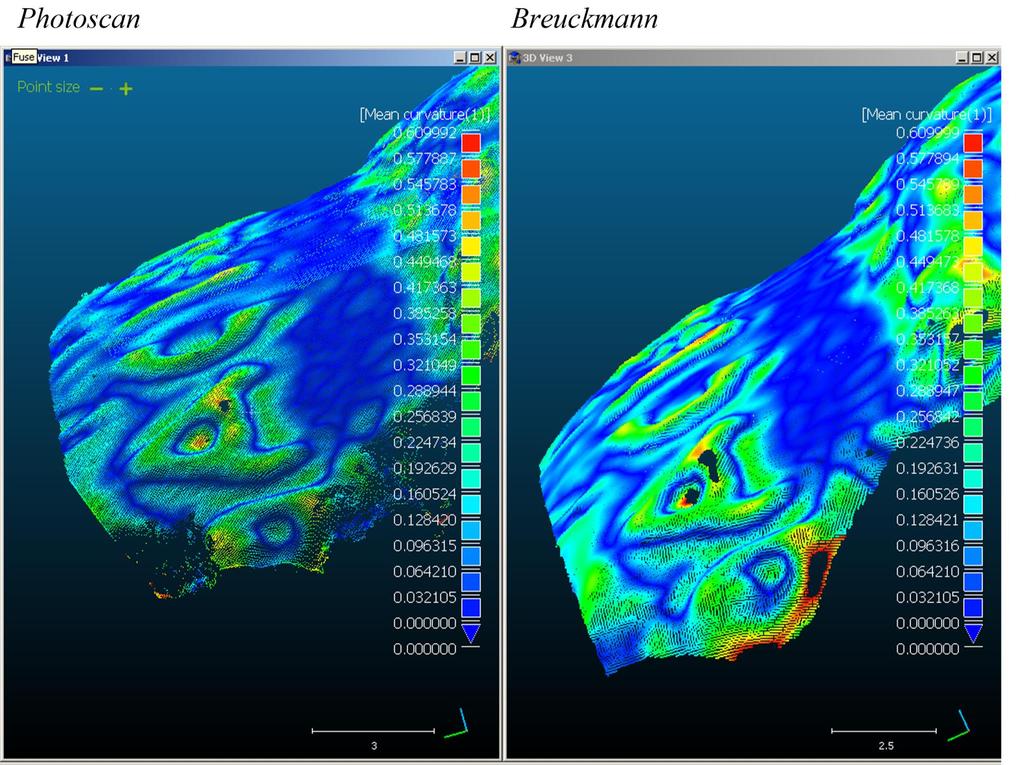
 12,059,870 faces, 6,036,297")
35 Meshed Polygonal Model (interpolated surface geometry) 12,059,870 faces, 6,036,297 vertices

36 Bad photos and unfortunate processing
37 Some examples of the increasing number of software solutions to process close range data Agisoft s PhotoScan and PhotoScan Pro Photomodeler and Photomodeler Scanner Visual SFM Mic-Mac and Apero 3DF Zephyr 123D Catch Python Photogrammetry Toolbox (and PPT GUI) SFM Toolkit Arc3D 3DM Analyst My3D Scanner Cubify Capture Insight 3D Pix4D Trimble s Inpho LPS BINGO for SOCET SET
38 123D Catch Visual SFM PhotoModeler Scanner Photoscan Naïve Processing Default/Blackbox processing Easier results for visualization Quick results Rigorous parameter selection Goal and project specific pipeline More metrically reliable Time and computation intensive
39 Most Common Software Comparison Pros Cons Visual SFM Good point matching algorithm No a priori camera calibration Focus can be adjusted Allows multiple focal lengths Free Allows for ground control points Significant distortion possible Processing intensive No friendly option for measuring scale only GCPs = 3D transformation only (no self calibration) Must export to another software for mesh generation (e.g. Meshlab) PhotoScan (Agisoft) Good point matching algorithm No a priori camera calibration Focus can be adjusted Allows multiple focal lengths Extremely detailed models Local processing (more control) Good parameter control relative to 123D Catch Detailed reporting/logs Processing intensive Memory intensive 12+ gb Less parameter control relative to PhotoModeler Scanner PhotoModeler Scanner Detailed reporting and logs Best parameter control Customizable processing Local Processing Fixed focus required A priori camera calibration required Matching algorithm is dated Time consuming with more manual intervention
40 HOW ACCURATE IS IT? SOFTWARE COMPARISONS With high precision 3D scanner model comparisons


41 General 3D Data Pipeline Scan subject Take Photos Derive point clouds Clean point clouds Register point clouds Generate Mesh Measure and Analyze Derive Textures and map to model Scale the model
42 D a t a C a p t u r e Breuckmann Scanning Close-Range Photogrammetry Environmental Conditions Field Time Requires low light and external power source (such as generator) Must scan at night when outdoors. 8 hrs = 1 x 2 m area at 0.06 mm resolution 2 x 2 m area at 0.15 mm resolution Works best with diffuse light. A sheet to minimize strong shadows may be necessary MUCH faster than the Breuckmann (Actual time depends on resolution) Data Depth Up to 6 cm at 0.06 mm resolution 23 cm at 0.15 mm resolution Infinity Problematic Surfaces Dark and/or shiny surfaces. Glass is impossible. Flat surfaces that are monochrome or have repetitive patterns Basic Processing Time 1/8 to 1/4 of the field time if no noise: e.g. 1-2 processing hours for 8 field hours 5-20 x s longer than field time Project Goals Metric precision and analysis of fine features not measurable with calipers Limited field time

43 Case Example: AMPHORA STAMP ANCIENT ATHENIAN AGORA In collaboration with the American School of Classical Studies, Athens


44 Amphora stamp PhotoScan Breuckmann Scanner 60 micron resolution Photomodeler Scanner Photogrammetry 123D Catch


45 Color Stripped Meshes PhotoScan Breuckmann Scanner 60 micron resolution Photomodeler Scanner 123D Catch
46

47


48 Object Models Breuckmann vs. Photogrammetry Photo 123D Catch Breuckmann Smartscan HE: 60 micron res Photoscan

49 Rock Art 123D Catch

50 Rock Art Photoscan

51 Case Example: KALAVASOS, CYPRUS In collaboration with the Kalavasos and Maroni Built Environments Project


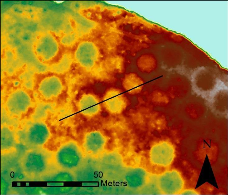
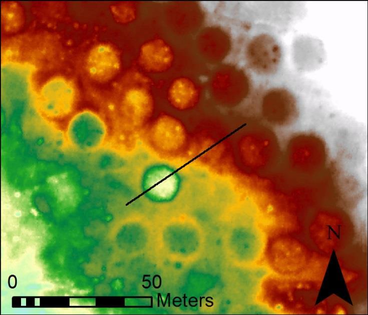
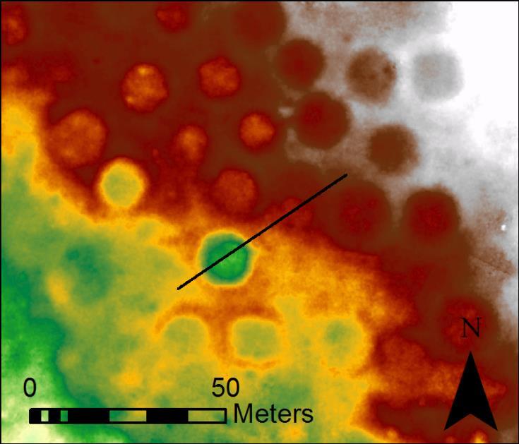
52 Photogrammetric Trench Profiles Visual SfM model Photoscan model


53 Trench Profiles Leica C10 laser scanning Visual SfM model Photoscan model
54 PhotoScan VS Scan Data Photoscan model Scan data
55 VSFM VS Scan Data VSFM model Scan data

56 PhotoScan VS Scan Data

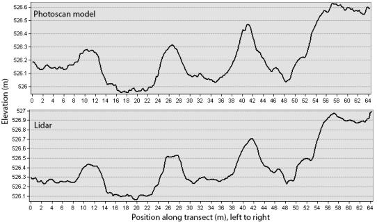
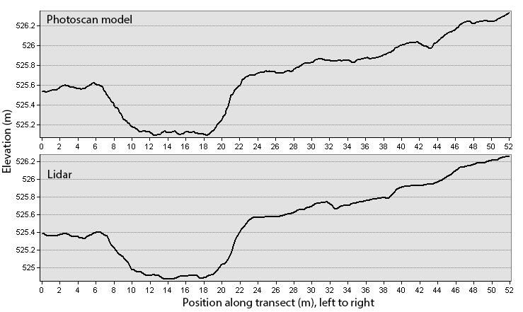
57 VSFM VS Scan Data
58 Collection and processing times Terrestrial CRP TLS Data Collection 78 photos in 4 min 8 scans 1.5 hrs Data Processing Medium quality Photoscan model in 5 hours 8 scans in 0.5 hr
59 HISTORIC PHOTO CASE EXAMPLES

60 Photogrammetry from historic photos Photoscan model from 2008 photos at Qarqur, Syria. Eric Jenson, University of Arkansas

61 Photogrammetry from historic photos DEM generated from historic images of Cusco, Peru Cotsen Institute/UCLA Geomatics Field school 2009
62 Archaeological Prospecting Case Example: FORT CLARK STATE HISTORIC SITE, NORTH DAKOTA In collaboration with
 = 16.0 points/m 2, ground point density = 4.0 points/m 2, vertical accuracy (RMSE) = 2.")
63 Elevation Model Data Sets 1) Lidar: Leica ALS60 system mounted in a Cessna Caravan 208B 900 x 1200 m survey area, average point density (first return) = 16.0 points/m 2, ground point density = 4.0 points/m 2, vertical accuracy (RMSE) = 2.4 cm 100 m
 100 m Borrow")


64 Lidar (Local Relief Model) 100 m Borrow pit with pathways Entryways, trails, and cabins Individual structures within Fort Clark

65 Fort Clark State Historic Site, North Dakota Elevation Model Data Sets 2) Digital photogrammetry: 34 digital color photographs (Konica Minolta DiMAGE A2) collected from a powered parachute Sensor size: 8.8 x 6.6 mm 7 mm focal length Flying height: ~285 m Pixel resolution: ~10 cm Check point error (RMSE) = ~14 cm horizontal and ~18 cm vertical Photos courtesy of Tommy Hailey, NSULA


66 Low Altitude Aerial Photogrammetry from Powered Parachute 750 x 850 m area 10 cm resolution DSM Point density: ~29 points/m m

67 Profile comparison 1985 B/W 2004 color Lidar
68 Profile comparison 1985 B/W 2004 color Lidar

69 Cloud Compare Lidar DEM Photoscan DSM Without photo alignment optimization

70 Cloud Compare Lidar DEM Photoscan DSM With photo alignment optimization


71 Case Example: COLLINS MOUND, AR In collaboration with the Stephanie Sullivan, PhD candidate, University of Arkansas

72 PhotoScan VS Scan Data

73 VSFM VS Scan Data

74 Side view of Collins

75 Qualitative Analysis Z-value (elevations) visualization Which datasets reveal which types of features Photoscan Z+F laser scanning

76 Qualitative Analysis Which datasets reveal which types of features Kite aerial photogrammetry Z+F laser scanning

77 Quantitative Analysis Hausdorff Distance in Meshlab Avg max distance = m mean distance = m


78 Quantitative Analysis Hausdorff Distance in Meshlab Avg max distance = m mean distance = m

79 Quantitative Analysis ArcMap max difference = 0.523m mean difference = 0.69m
80 Collection and processing times Aerial CRP TLS Data Collection 28 photos in 3 min 55 in 6 min 7 scans in 2.5 hrs 7 scans 3.5 hrs Data Processing Medium quality Photoscan model in 3 hours Medium quality Photoscan model in 4 hours 7 scans in 1 hr 7 scans in 1 hr


81 Kite aerial/uav photography will yield good geometry of low architectural remains. Period. Kite aerial photogrammetry Leica C10 laser scanning KAMBE Project, Kalavasos, Cyprus
82 Conclusions Keep your project goals in focus at all times Know your camera and lenses Know the basics of photogrammetry and how that relates to your software settings You can get by with leaving default settings and pressing just a few buttons will that meet your project goals? Photogrammetry can be good solution Great for visualization Must be executed with great care for metric analysis
ARCHIVAL 3D PHOTOGRAPHY
 CENTER FOR DIGITAL ARCHAEOLOGY ARCHIVAL 3D PHOTOGRAPHY Michael Ashley michael@codifi.org Hello, I'm Michael Ashley from the Center for Digital Archaeology and I am excited to talk about archival 3D photography.
CSI: Rombalds Moor Photogrammetry Photography
 Photogrammetry Photography Photogrammetry Training 26 th March 10:00 Welcome Presentation image capture Practice 12:30 13:15 Lunch More practice 16:00 (ish) Finish or earlier What is photogrammetry 'photo'
Structure from Motion (SfM) Photogrammetry Field Methods Manual for Students
 Photogrammetry Field Methods Manual for Students") Structure from Motion (SfM) Photogrammetry Field Methods Manual for Students Written by Katherine Shervais (UNAVCO) Introduction to SfM for Field Education The purpose of the Analyzing High Resolution
Structure from Motion (SfM) Photogrammetry Field Methods Manual for Students Written by Katherine Shervais (UNAVCO) Introduction to SfM for Field Education The purpose of the Analyzing High Resolution
Phase One ixu-rs1000 Accuracy Assessment Report Yu. Raizman, PhaseOne.Industrial, Israel
 17 th International Scientific and Technical Conference FROM IMAGERY TO DIGITAL REALITY: ERS & Photogrammetry Phase One ixu-rs1000 Accuracy Assessment Report Yu. Raizman, PhaseOne.Industrial, Israel 1.
Introduction to Photography - Lesson 1
 - Photography is an amazing subject with an ever broadening appeal. As the technology becomes more freely available what was once the exclusive territory of the wealthy professional is now accessible to
2019 NYSAPLS Conf> Fundamentals of Photogrammetry for Land Surveyors
 2019 NYSAPLS Conf> Fundamentals of Photogrammetry for Land Surveyors George Southard GSKS Associates LLC Introduction George Southard: Master s Degree in Photogrammetry and Cartography 40 years working
IMAGE ACQUISITION GUIDELINES FOR SFM
 IMAGE ACQUISITION GUIDELINES FOR SFM a.k.a. Close-range photogrammetry (as opposed to aerial/satellite photogrammetry) Basic SfM requirements (The Golden Rule): minimum of 60% overlap between the adjacent
Aerial photography: Principles. Frame capture sensors: Analog film and digital cameras
 Aerial photography: Principles Frame capture sensors: Analog film and digital cameras Overview Introduction Frame vs scanning sensors Cameras (film and digital) Photogrammetry Orthophotos Air photos are
Technical Evaluation of Khartoum State Mapping Project
 Technical Evaluation of Khartoum State Mapping Project Nagi Zomrawi 1 and Mohammed Fator 2 1 School of Surveying Engineering, Collage of Engineering, Sudan University of Science and Technology, Khartoum,
Leica - 3 rd Generation Airborne Digital Sensors Features / Benefits for Remote Sensing & Environmental Applications
 Leica - 3 rd Generation Airborne Digital Sensors Features / Benefits for Remote Sensing & Environmental Applications Arthur Rohrbach, Sensor Sales Dir Europe, Middle-East and Africa (EMEA) Luzern, Switzerland,
State Library of Queensland Digitisation Toolkit: Scanning and capture guide for image-based material
 State Library of Queensland Digitisation Toolkit: Scanning and capture guide for image-based material Introduction While the term digitisation can encompass a broad range, for the purposes of this guide,
Validation of the QuestUAV PPK System
 Validation of the QuestUAV PPK System 3cm in xy, 400ft, no GCPs, 100Ha, 25 flights Nigel King 1, Kerstin Traut 2, Cameron Weeks 3 & Ruairi Hardman 4 1 Director QuestUAV, 2 Data Analyst QuestUAV, 3 Production
Leica ADS80 - Digital Airborne Imaging Solution NAIP, Salt Lake City 4 December 2008
 Luzern, Switzerland, acquired at 5 cm GSD, 2008. Leica ADS80 - Digital Airborne Imaging Solution NAIP, Salt Lake City 4 December 2008 Shawn Slade, Doug Flint and Ruedi Wagner Leica Geosystems AG, Airborne
UltraCam and UltraMap Towards All in One Solution by Photogrammetry
 Photogrammetric Week '11 Dieter Fritsch (Ed.) Wichmann/VDE Verlag, Belin & Offenbach, 2011 Wiechert, Gruber 33 UltraCam and UltraMap Towards All in One Solution by Photogrammetry ALEXANDER WIECHERT, MICHAEL
DIGITAL PHOTOGRAPHY FOR OBJECT DOCUMENTATION GOOD, BETTER, BEST
 DIGITAL PHOTOGRAPHY FOR OBJECT DOCUMENTATION GOOD, BETTER, BEST INTRODUCTION This document will introduce participants in the techniques and procedures of collection documentation without the necessity
ASPECTS OF DEM GENERATION FROM UAS IMAGERY
 ASPECTS OF DEM GENERATION FROM UAS IMAGERY A. Greiwea,, R. Gehrke a,, V. Spreckels b,, A. Schlienkamp b, Department Architecture, Civil Engineering and Geomatics, Fachhochschule Frankfurt am Main, Germany
Sample Copy. Not For Distribution.
 Photogrammetry, GIS & Remote Sensing Quick Reference Book i EDUCREATION PUBLISHING Shubham Vihar, Mangla, Bilaspur, Chhattisgarh - 495001 Website: www.educreation.in Copyright, 2017, S.S. Manugula, V.
Film Cameras Digital SLR Cameras Point and Shoot Bridge Compact Mirror less
 Film Cameras Digital SLR Cameras Point and Shoot Bridge Compact Mirror less Portraits Landscapes Macro Sports Wildlife Architecture Fashion Live Music Travel Street Weddings Kids Food CAMERA SENSOR
FOCUS, EXPOSURE (& METERING) BVCC May 2018
 BVCC May 2018") FOCUS, EXPOSURE (& METERING) BVCC May 2018 SUMMARY Metering in digital cameras. Metering modes. Exposure, quick recap. Exposure settings and modes. Focus system(s) and camera controls. Challenges & Experiments.
FOCUS, EXPOSURE (& METERING) BVCC May 2018 SUMMARY Metering in digital cameras. Metering modes. Exposure, quick recap. Exposure settings and modes. Focus system(s) and camera controls. Challenges & Experiments.
Standard Operating Procedure for Flat Port Camera Calibration
 Standard Operating Procedure for Flat Port Camera Calibration Kevin Köser and Anne Jordt Revision 0.1 - Draft February 27, 2015 1 Goal This document specifies the practical procedure to obtain good images
Capturing Realistic HDR Images. Dave Curtin Nassau County Camera Club February 24 th, 2016
 Capturing Realistic HDR Images Dave Curtin Nassau County Camera Club February 24 th, 2016 Capturing Realistic HDR Images Topics: What is HDR? In Camera. Post-Processing. Sample Workflow. Q & A. Capturing
6.098 Digital and Computational Photography Advanced Computational Photography. Bill Freeman Frédo Durand MIT - EECS
 6.098 Digital and Computational Photography 6.882 Advanced Computational Photography Bill Freeman Frédo Durand MIT - EECS Administrivia PSet 1 is out Due Thursday February 23 Digital SLR initiation? During
Camera Calibration Certificate No: DMC II
 Calibration DMC II 230 015 Camera Calibration Certificate No: DMC II 230 015 For Air Photographics, Inc. 2115 Kelly Island Road MARTINSBURG WV 25405 USA Calib_DMCII230-015_2014.docx Document Version 3.0
DSLR Essentials: Class Notes
 DSLR Essentials: Class Notes The digital SLR has seen a surge in popularity in recent years. Many are enjoying the superior photographic experiences provided by these feature packed cameras. Interchangeable
Camera Calibration Certificate No: DMC III 27542
 Calibration DMC III Camera Calibration Certificate No: DMC III 27542 For Peregrine Aerial Surveys, Inc. #201 1255 Townline Road Abbotsford, B.C. V2T 6E1 Canada Calib_DMCIII_27542.docx Document Version
Camera Calibration Certificate No: DMC IIe
 Calibration DMC IIe 230 23522 Camera Calibration Certificate No: DMC IIe 230 23522 For Richard Crouse & Associates 467 Aviation Way Frederick, MD 21701 USA Calib_DMCIIe230-23522.docx Document Version 3.0
A New Capability for Crash Site Documentation
 A New Capability for Crash Site Documentation By Major Adam Cybanski, Directorate of Flight Safety, Ottawa Major Adam Cybanski is the officer responsible for helicopter investigation (DFS 2-4) at the Canadian
Camera Calibration Certificate No: DMC II
 Calibration DMC II 140-036 Camera Calibration Certificate No: DMC II 140-036 For Midwest Aerial Photography 7535 West Broad St, Galloway, OH 43119 USA Calib_DMCII140-036.docx Document Version 3.0 page
How to photograph small to medium 2-D artwork
 University of Colorado at Boulder Department of Art & Art History Lia Pileggi Lia.Pileggi@colorado.edu http://cuart.colorado.edu/resources/vrc/ How to photograph small to medium 2-D artwork Hanging your
CALIBRATING THE NEW ULTRACAM OSPREY OBLIQUE AERIAL SENSOR Michael Gruber, Wolfgang Walcher
 CALIBRATING THE NEW ULTRACAM OSPREY OBLIQUE AERIAL SENSOR Michael Gruber, Wolfgang Walcher Microsoft UltraCam Business Unit Anzengrubergasse 8/4, 8010 Graz / Austria {michgrub, wwalcher}@microsoft.com
Update on UltraCam and UltraMap technology
 Update on UltraCam and UltraMap technology Alexander Wiechert, Michael Gruber Anzengrubergasse 8/4, 8010 Graz, Austria {alexander.wiechert, michael.gruber}@vexcel-imaging.com Stuttgart, September 2017
9/19/16. A Closer Look. Danae Wolfe. What We ll Cover. Basics of photography & your camera. Technical. Macro & close-up techniques.
 A Closer Look Danae Wolfe What We ll Cover Basics of photography & your camera Technical Macro & close-up techniques Creative 1 What is Photography? Photography: the art, science, & practice of creating
Digital Aerial Photography UNBC March 22, Presented by: Dick Mynen TDB Consultants Inc.
 Digital Aerial Photography UNBC March 22, 2011 Presented by: Dick Mynen TDB Consultants Inc. Airborne Large Scale Digital Photography Who is using the technology in today s environment Options available
Intro to Digital SLR and ILC Photography Week 1 The Camera Body
 Intro to Digital SLR and ILC Photography Week 1 The Camera Body Instructor: Roger Buchanan Class notes are available at www.thenerdworks.com Course Outline: Week 1 Camera Body; Week 2 Lenses; Week 3 Accessories,
Camera Calibration Certificate No: DMC II
 Calibration DMC II 140-005 Camera Calibration Certificate No: DMC II 140-005 For Midwest Aerial Photography 7535 West Broad St, Galloway, OH 43119 USA Calib_DMCII140-005.docx Document Version 3.0 page
Camera Calibration Certificate No: DMC II
 Calibration DMC II 230 027 Camera Calibration Certificate No: DMC II 230 027 For Peregrine Aerial Surveys, Inc. 103-20200 56 th Ave Langley, BC V3A 8S1 Canada Calib_DMCII230-027.docx Document Version 3.0
Nikon f/ g Evaluation
 Nikon 80-400 f/4.5-5.6g Evaluation Killdeer - D7100 in 1.3x DX crop mode handheld, 80-200 f/4.5-5.6g @ 400mm Construction: The 80-400 f/4.5-5.6g is a relatively large and bulky lens for the genre but overall,
MINNESOTA DEPARTMENT OF TRANSPORTATION OFFICE OF LAND MANAGEMENT SURVEYING AND MAPPING SECTION PHOTOGRAMMETRY UNIT
 SEP. 2011 MINNESOTA DEPARTMENT OF TRANSPORTATION OFFICE OF LAND MANAGEMENT SURVEYING AND MAPPING SECTION PHOTOGRAMMETRY UNIT SPECIAL PROVISIONS FOR: GROUP 1: AERIAL PHOTOGRAPHY/PHOTOGRAMMETRIC LAB SERVICES
Camera Calibration Certificate No: DMC II
 Calibration DMC II 230 020 Camera Calibration Certificate No: DMC II 230 020 For MGGP Aero Sp. z o.o. ul. Słowackiego 33-37 33-100 Tarnów Poland Calib_DMCII230-020.docx Document Version 3.0 page 1 of 40
Camera Calibration Certificate No: DMC II Aero Photo Europe Investigation
 Calibration DMC II 250 030 Camera Calibration Certificate No: DMC II 250 030 For Aero Photo Europe Investigation Aerodrome de Moulins Montbeugny Yzeure Cedex 03401 France Calib_DMCII250-030.docx Document
Phase One 190MP Aerial System
 White Paper Phase One 190MP Aerial System Introduction Phase One Industrial s 100MP medium format aerial camera systems have earned a worldwide reputation for its high performance. They are commonly used
DEM Generation Using a Digital Large Format Frame Camera
 DEM Generation Using a Digital Large Format Frame Camera Joachim Höhle Abstract Progress in automated photogrammetric DEM generation is presented. Starting from the procedures and the performance parameters
sensefly Camera Collection
 Camera Collection A professional sensor for every application Introducing S.O.D.A. 3D 3D mapping, redefined Image: S.O.D.A. 3D oblique image (left) merging into 3D mesh (right). Stunning digital 3D reconstructions
PHOTOGRAMMETRIC RESECTION DIFFERENCES BASED ON LABORATORY vs. OPERATIONAL CALIBRATIONS
 PHOTOGRAMMETRIC RESECTION DIFFERENCES BASED ON LABORATORY vs. OPERATIONAL CALIBRATIONS Dean C. MERCHANT Topo Photo Inc. Columbus, Ohio USA merchant.2@osu.edu KEY WORDS: Photogrammetry, Calibration, GPS,
Volume 1 - Module 6 Geometry of Aerial Photography. I. Classification of Photographs. Vertical
 RSCC Volume 1 Introduction to Photo Interpretation and Photogrammetry Table of Contents Module 1 Module 2 Module 3.1 Module 3.2 Module 4 Module 5 Module 6 Module 7 Module 8 Labs Volume 1 - Module 6 Geometry
** KEYSTONE AERIAL SURVEYS R. David Day, Wesley Weaver **
 AN ACCURACY ANALYSIS OF LARGE RESOLUTION IMAGES CAPTURED WITH THE NIKON D810 DIGITAL CAMERA SYSTEM Ricardo M. Passini * * ricardopassini2012@outlook.com ** KEYSTONE AERIAL SURVEYS R. David Day, Wesley
Lenses, exposure, and (de)focus
focus") Lenses, exposure, and (de)focus http://graphics.cs.cmu.edu/courses/15-463 15-463, 15-663, 15-862 Computational Photography Fall 2017, Lecture 15 Course announcements Homework 4 is out. - Due October 26
Lenses, exposure, and (de)focus http://graphics.cs.cmu.edu/courses/15-463 15-463, 15-663, 15-862 Computational Photography Fall 2017, Lecture 15 Course announcements Homework 4 is out. - Due October 26
Introduction to Photogrammetry
 Introduction to Photogrammetry Presented By: Sasanka Madawalagama Geoinformatics Center Asian Institute of Technology Thailand www.geoinfo.ait.asia Content Introduction to photogrammetry 2D to 3D Drones
VisionMap Sensors and Processing Roadmap
 Vilan, Gozes 51 VisionMap Sensors and Processing Roadmap YARON VILAN, ADI GOZES, Tel-Aviv ABSTRACT The A3 is a family of digital aerial mapping cameras and photogrammetric processing systems, which is
TAKING GREAT PICTURES. A Modest Introduction
 TAKING GREAT PICTURES A Modest Introduction HOW TO CHOOSE THE RIGHT CAMERA EQUIPMENT WE ARE NOW LIVING THROUGH THE GOLDEN AGE OF PHOTOGRAPHY Rapid innovation gives us much better cameras and photo software...
HIGH RESOLUTION COLOR IMAGERY FOR ORTHOMAPS AND REMOTE SENSING. Author: Peter Fricker Director Product Management Image Sensors
 HIGH RESOLUTION COLOR IMAGERY FOR ORTHOMAPS AND REMOTE SENSING Author: Peter Fricker Director Product Management Image Sensors Co-Author: Tauno Saks Product Manager Airborne Data Acquisition Leica Geosystems
PHOTOGRAPHING THE LUNAR ECLIPSE
 1/29/18 PHOTOGRAPHING THE LUNAR ECLIPSE NICK SINNOTT CHICAGO PHOTOGRAPHY CLASSES PREPARATION TIMING AND FINDING LOCATION https://www.timeanddate.com/moon/phases/ - Dates of Lunar Phases 1 PREPARATION TIMING
ALPHASTUDIO COMPACT ADVANCED PHOTO STUDIO FOR AUTOMATED PRODUCT PHOTOGRAPHY FOR MEDIUM- TO LARGE-SIZED OBJECTS
 ALPHASTUDIO COMPACT ADVANCED PHOTO STUDIO FOR AUTOMATED PRODUCT PHOTOGRAPHY FOR MEDIUM- TO LARGE-SIZED OBJECTS CUT COSTS INCREASE SALES SPEED UP WORKFLOW 360 VIEW orbitvu.com/stroller See me spinning!
This has given you a good introduction to the world of photography, however there are other important and fundamental camera functions and skills
 THE DSLR CAMERA Before we Begin For those of you who have studied photography the chances are that in most cases you have been using a digital compact camera. This has probably involved you turning the
UAV PHOTOGRAMMETRY COMPARED TO TRADITIONAL RTK GPS SURVEYING
 UAV PHOTOGRAMMETRY COMPARED TO TRADITIONAL RTK GPS SURVEYING Brad C. Mathison and Amber Warlick March 20, 2016 Fearless Eye Inc. Kansas City, Missouri www.fearlesseye.com KEY WORDS: UAV, UAS, Accuracy
Produce stunning. Pro photographer Chris Humphreys guides you through HDR and how to create captivating natural-looking images
 Masterclass: In association with Produce stunning HDR images Pro photographer Chris Humphreys guides you through HDR and how to create captivating natural-looking images 8 digital photographer 45 masterclass4produce
Five Sensors, One Day: Unmanned vs. Manned Logistics and Accuracy
 Five Sensors, One Day: Unmanned vs. Manned Logistics and Accuracy ASPRS UAS Mapping Technical Symposium Sept 13 th, 2016 Presenter: David Day, CP, GISP Keystone Aerial Surveys, Inc. Summary of activities
Geometry of Aerial Photographs
 Geometry of Aerial Photographs Aerial Cameras Aerial cameras must be (details in lectures): Geometrically stable Have fast and efficient shutters Have high geometric and optical quality lenses They can
TAKING GREAT PICTURES. A Modest Introduction
 TAKING GREAT PICTURES A Modest Introduction 1 HOW TO CHOOSE THE RIGHT CAMERA EQUIPMENT 2 THE REALLY CONFUSING CAMERA MARKET Hundreds of models are now available Canon alone has 41 models 28 compacts and
Introduction to 2-D Copy Work
 Introduction to 2-D Copy Work What is the purpose of creating digital copies of your analogue work? To use for digital editing To submit work electronically to professors or clients To share your work
Digital Photogrammetry. Presented by: Dr. Hamid Ebadi
 Digital Photogrammetry Presented by: Dr. Hamid Ebadi Background First Generation Analog Photogrammetry Analytical Photogrammetry Digital Photogrammetry Photogrammetric Generations 2000 digital photogrammetry
Aerial Triangulation Radiometry Essentials Dense Matching Ortho Generation
 Radiometry Aerial Triangulation Essentials Dense Matching Ortho Generation Highly advanced photogrammetric workflow system for UltraCam images. Microsoft UltraMap is a state-of-the-art, end-to-end, complete
Lens Aperture. South Pasadena High School Final Exam Study Guide- 1 st Semester Photo ½. Study Guide Topics that will be on the Final Exam
 South Pasadena High School Final Exam Study Guide- 1 st Semester Photo ½ Study Guide Topics that will be on the Final Exam The Rule of Thirds Depth of Field Lens and its properties Aperture and F-Stop
Presented to you today by the Fort Collins Digital Camera Club
 Presented to you today by the Fort Collins Digital Camera Club www.fcdcc.com Photography: February 19, 2011 Fort Collins Digital Camera Club 2 Film Photography: Photography using light sensitive chemicals
A Study of Slanted-Edge MTF Stability and Repeatability
 A Study of Slanted-Edge MTF Stability and Repeatability Jackson K.M. Roland Imatest LLC, 2995 Wilderness Place Suite 103, Boulder, CO, USA ABSTRACT The slanted-edge method of measuring the spatial frequency
Which equipment is necessary? How is the panorama created?
 Congratulations! By purchasing your Panorama-VR-System you have acquired a tool, which enables you - together with a digital or analog camera, a tripod and a personal computer - to generate high quality
GEO 428: DEMs from GPS, Imagery, & Lidar Tuesday, September 11
 GEO 428: DEMs from GPS, Imagery, & Lidar Tuesday, September 11 Global Positioning Systems GPS is a technology that provides Location coordinates Elevation For any location with a decent view of the sky
Creating Stitched Panoramas
 Creating Stitched Panoramas Here are the topics that we ll cover 1. What is a stitched panorama? 2. What equipment will I need? 3. What settings & techniques do I use? 4. How do I stitch my images together
ContextCapture Quick guide for photo acquisition
 ContextCapture Quick guide for photo acquisition ContextCapture is automatically turning photos into 3D models, meaning that the quality of the input dataset has a deep impact on the output 3D model which
THE DIFFERENCE MAKER COMPARISON GUIDE
 THE DIFFERENCE MAKER D850 vs D810 Feature Set D850 Resolution 45.7 Megapixels D810 ISO Range 99 Cross Type AF Points Cross type AF points +++++++++++++++++++++++++++++++++++ +++++++++++++++++++++++++++++++++++
Close-Range Photogrammetry for Accident Reconstruction Measurements
 Close-Range Photogrammetry for Accident Reconstruction Measurements iwitness TM Close-Range Photogrammetry Software www.iwitnessphoto.com Lee DeChant Principal DeChant Consulting Services DCS Inc Bellevue,
Introductory Photography
 Introductory Photography Basic concepts + Tips & Tricks Ken Goldman Apple Pi General Meeting 26 June 2010 Kenneth R. Goldman 1 The Flow General Thoughts Cameras Composition Miscellaneous Tips & Tricks
MODERN PROCESSING CAPABILITIES OF ANALOG DATA FROM DOCUMENTATION OF THE GREAT OMAYYAD MOSQUE IN ALEPPO, SYRIA, DAMAGED IN CIVIL WAR
 MODERN PROCESSING CAPABILITIES OF ANALOG DATA FROM DOCUMENTATION OF THE GREAT OMAYYAD MOSQUE IN ALEPPO, SYRIA, DAMAGED IN CIVIL WAR K.Pavelka a, J.Šedina a, P.Raeva a, M. Hůlková a a Czech Technical University
MINIMISING SYSTEMATIC ERRORS IN DEMS CAUSED BY AN INACCURATE LENS MODEL
 MINIMISING SYSTEMATIC ERRORS IN DEMS CAUSED BY AN INACCURATE LENS MODEL R. Wackrow a, J.H. Chandler a and T. Gardner b a Dept. Civil and Building Engineering, Loughborough University, LE11 3TU, UK (r.wackrow,
Lesson 4: Photogrammetry
 This work by the National Information Security and Geospatial Technologies Consortium (NISGTC), and except where otherwise Development was funded by the Department of Labor (DOL) Trade Adjustment Assistance
The Essential Guide To Capturing Birds In Flight
 The Essential Guide To Capturing Birds In Flight Written by Nina Bailey Especially for Canon EOS cameras Chapter 01: Introduction to photographing birds in flight 2 Written, designed and images by Nina
Time-Lapse Panoramas for the Egyptian Heritage
 Time-Lapse Panoramas for the Egyptian Heritage Mohammad NABIL Anas SAID CULTNAT, Bibliotheca Alexandrina While laser scanning and Photogrammetry has become commonly-used methods for recording historical
A Digital Camera Glossary. Ashley Rodriguez, Charlie Serrano, Luis Martinez, Anderson Guatemala PERIOD 6
 A Digital Camera Glossary Ashley Rodriguez, Charlie Serrano, Luis Martinez, Anderson Guatemala PERIOD 6 A digital Camera Glossary Ivan Encinias, Sebastian Limas, Amir Cal Ivan encinias Image sensor A silicon
Metric Accuracy Testing with Mobile Phone Cameras
 Metric Accuracy Testing with Mobile Phone Cameras Armin Gruen,, Devrim Akca Chair of Photogrammetry and Remote Sensing ETH Zurich Switzerland www.photogrammetry.ethz.ch Devrim Akca, the 21. ISPRS Congress,
Blue Hour and HDR Tutorial by John Strung
 Blue Hour and HDR Tutorial by John Strung the Blue Hour is a wonderful time of night when photography can yield images of intense blue colours. Blue Hour is a bit of a misnomer for two reasons. There are
Nikon 24mm f/2.8d AF Nikkor (Tested)
") Nikon 24mm f/2.8d AF Nikkor (Tested) Name Nikon 24mm ƒ/2.8d AF Nikkor Image Circle 35mm Type Wide Prime Focal Length 24mm APS Equivalent 36mm Max Aperture ƒ/2.8 Min Aperture ƒ/22 Diaphragm Blades 7 Lens
Nikon 24mm f/2.8d AF Nikkor (Tested) Name Nikon 24mm ƒ/2.8d AF Nikkor Image Circle 35mm Type Wide Prime Focal Length 24mm APS Equivalent 36mm Max Aperture ƒ/2.8 Min Aperture ƒ/22 Diaphragm Blades 7 Lens
PROPERTY OF THE LARGE FORMAT DIGITAL AERIAL CAMERA DMC II
 PROPERTY OF THE LARGE FORMAT DIGITAL AERIAL CAMERA II K. Jacobsen a, K. Neumann b a Institute of Photogrammetry and GeoInformation, Leibniz University Hannover, Germany jacobsen@ipi.uni-hannover.de b Z/I
Digitizing Film Using the D850 and ES-2 Negative Digitizer
 JULY 23, 2018 INTERMEDIATE Digitizing Film Using the D850 and ES-2 Negative Digitizer The ES 2 can be used with both strip film and mounted slides. Digitizing film is the process of creating digital data
not to be republished NCERT Introduction To Aerial Photographs Chapter 6
 Chapter 6 Introduction To Aerial Photographs Figure 6.1 Terrestrial photograph of Mussorrie town of similar features, then we have to place ourselves somewhere in the air. When we do so and look down,
Lab #10 Digital Orthophoto Creation (Using Leica Photogrammetry Suite)
") Lab #10 Digital Orthophoto Creation (Using Leica Photogrammetry Suite) References: Leica Photogrammetry Suite Project Manager: Users Guide, Leica Geosystems LLC. Leica Photogrammetry Suite 9.2 Introduction:
Lab #10 Digital Orthophoto Creation (Using Leica Photogrammetry Suite) References: Leica Photogrammetry Suite Project Manager: Users Guide, Leica Geosystems LLC. Leica Photogrammetry Suite 9.2 Introduction:
Chapter 2-Digital Components
 Chapter 2-Digital Components What Makes Digital Cameras Work? This is how the D-SLR (Digital Single Lens Reflex) Camera works. The sensor This is the light sensitive part of your camera There are two basic
Vexcel Imaging GmbH Innovating in Photogrammetry: UltraCamXp, UltraCamLp and UltraMap
 Photogrammetric Week '09 Dieter Fritsch (Ed.) Wichmann Verlag, Heidelberg, 2009 Wiechert, Gruber 27 Vexcel Imaging GmbH Innovating in Photogrammetry: UltraCamXp, UltraCamLp and UltraMap ALEXANDER WIECHERT,
Basics of Photographing Star Trails
 Basics of Photographing Star Trails By Rick Graves November 15, 2016 1 What are Star Trails? Night sky images with foreground elements that show the passage of time and the motion of the stars 2 Which
Macro and Close-up Photography
 Photo by Daniel Schwen Macro and Close-up Photography Digital Photography DeCal 2010 Nathan Yan Kellen Freeman Some slides adapted from Zexi Eric Yan What Is Macro Photography? Macro commonly refers to
Get the Shot! Photography + Instagram Workshop September 21, 2013 BlogPodium. Saturday, 21 September, 13
 Get the Shot! Photography + Instagram Workshop September 21, 2013 BlogPodium Part One: Taking your camera off manual Technical details Common problems and how to fix them Practice Ways to make your photos
Baldwin and Mobile Counties, AL Orthoimagery Project Report. Submitted: March 23, 2016
 2015 Orthoimagery Project Report Submitted: Prepared by: Quantum Spatial, Inc 523 Wellington Way, Suite 375 Lexington, KY 40503 859-277-8700 Page i of iii Contents Project Report 1. Summary / Scope...
SCIENCE & TECHNOLOGY
 Pertanika J. Sci. & Technol. 21 (2): 387-396 (2013) SCIENCE & TECHNOLOGY Journal homepage: http://www.pertanika.upm.edu.my/ Production of Orthophoto and Volume Determination Using Low-Cost Digital Cameras
ALPHASHOT 360 AUTOMATED PHOTO STUDIO FOR SMALL-SIZED PRODUCTS CUT COSTS INCREASE SALES SPEED UP WORKFLOW
 ALPHASHOT 360 AUTOMATED PHOTO STUDIO FOR SMALL-SIZED PRODUCTS CUT COSTS INCREASE SALES SPEED UP WORKFLOW Put your products in the spotlight! IN-HOUSE AUTOMATED PHOTO STUDIO FOR SMALL-SIZED PRODUCTS VIEW
VERIFICATION OF POTENCY OF AERIAL DIGITAL OBLIQUE CAMERAS FOR AERIAL PHOTOGRAMMETRY IN JAPAN
 VERIFICATION OF POTENCY OF AERIAL DIGITAL OBLIQUE CAMERAS FOR AERIAL PHOTOGRAMMETRY IN JAPAN Ryuji. Nakada a, *, Masanori. Takigawa a, Tomowo. Ohga a, Noritsuna. Fujii a a Asia Air Survey Co. Ltd., Kawasaki
UAS Photogrammetry Best Practices
 UAS Photogrammetry Best Practices Pennsylvania Society of Land Surveyors January 15, 2019 Bryan Baker Certified Mapping Scientist (UAS) Bryan Baker UAS Sales Manager Leica Geosystems Reality Capture Team
Revolutionary optics for macro and landscapes.
 Revolutionary optics for macro and landscapes. PRICING Zero D Wide Angle Angle Range 12MM F/2.8 ZERO DISTORTION 15MM F/2 ZERO DISTORTION 9MM F/2.8 ZERO DISTORTION 7.5MM F/2 ZERO DISTORTION AVAILABLE MOUNTS:
Table of Contents. 1. High-Resolution Images with the D800E Aperture and Complex Subjects Color Aliasing and Moiré...
 Technical Guide Introduction This Technical Guide details the principal techniques used to create two of the more technically advanced photographs in the D800/D800E brochure. Take this opportunity to admire
Chapters 1-3. Chapter 1: Introduction and applications of photogrammetry Chapter 2: Electro-magnetic radiation. Chapter 3: Basic optics
 Chapters 1-3 Chapter 1: Introduction and applications of photogrammetry Chapter 2: Electro-magnetic radiation Radiation sources Classification of remote sensing systems (passive & active) Electromagnetic
POTENTIAL OF LARGE FORMAT DIGITAL AERIAL CAMERAS. Dr. Karsten Jacobsen Leibniz University Hannover, Germany
 POTENTIAL OF LARGE FORMAT DIGITAL AERIAL CAMERAS Dr. Karsten Jacobsen Leibniz University Hannover, Germany jacobsen@ipi.uni-hannover.de Introduction: Digital aerial cameras are replacing traditional analogue
Chapters 1-3. Chapter 1: Introduction and applications of photogrammetry Chapter 2: Electro-magnetic radiation. Chapter 3: Basic optics
 Chapters 1-3 Chapter 1: Introduction and applications of photogrammetry Chapter 2: Electro-magnetic radiation Radiation sources Classification of remote sensing systems (passive & active) Electromagnetic