Enrique Gonzalez-Velez Civil and Environmental Engineering University of South Florida
|
|
|
- Grant Hancock
- 6 years ago
- Views:
Transcription

1 Enrique Gonzalez-Velez Civil and Environmental Engineering University of South Florida


2 Background Objective Introduction Roadway Lighting Literature Review Study Area Data Illuminance, Crash, and Roadway Future Work Acknowledgements
3 2007 Nationwide Data 37,248 fatal crashes occurred in the USA 36% occurred during dark condition (non present of astronomical light - 9:00 p.m. to 6:00 a.m.) In Florida reports show 2,943 fatal crashes 8% of the nationwide fatalities 40% respectively occurred during dark period FARS Encyclopedia. USDOT and NHTSA:
4


5 Nationwide Fatal Crashes Florida Fatal Crashes 39,500 39,000 38,500 38,000 37,500 37,000 36,500 36,000 35,500 35,000 34,500 4,000 3,500 3,000 2,500 2,000 1,500 1, FARS Encyclopedia. USDOT and NHTSA:


6 To find out the relationship between nighttime accidents and street illuminance lighting levels. This includes the analysis of crash data and the illuminance level measured.
.")
7 Nighttime traffic accident rates are considerably higher. Only approximate 24 percent of the vehicle-miles traveled occur at night (Florida 24 hr counts data). Many research indicates a significant reduction in the number of crashes when roadway lighting is installed.

8 Roadway Lighting main objectives: supplement vehicle headlights, extending the visibility range beyond their limits improve the visibility of roadway features and objects on or near the roadway delineate the roadway ahead crime reduction traffic safety
9 Different methods: Luminance Small Target Visibility (STV) Illuminance
10 Used to evaluate lighting design Measure the reflectance of the roadway surface Inappropriate for the evaluation of lighting system
11 Source: AASHTO Roadway Lighting Design Guides (2005)
12 Source: AASHTO Roadway Lighting Design Guides Appendices (2005)

13 The total amount of visible light illuminating a point on a surface from all directions above the surface. This "surface" can be a physical surface or an imaginary plane. Standard units: Lux (lx) (lm/m 2 ) Footcandle (fc) (lm/ft 2 )
14 Source: IESNA Guide for Photometric Measurement of Roadway Lighting Illuminations (LM-50-99)
15 Author & Year Summary Findings Box (1972) Walker (1976) Present the findings of a study in were the relation between freeway accident and illumination level was analyzed. Accident frequency for rural at grade intersections was determined for 3 years periods immediately before and after lighting. Box (1976) Before and after study on 2.5 miles State Highway 60, Gulf to Bay Boulevard, Clearwater Florida. In this study lamps were turned off. An Average reduction of 40% on nighttime accidents was found as a result of lighting. Rate of accidents was reduced from 1.89 to 0.91 accidents/mev, representing a 52% reduction. In general, lighting significantly reduced the number of night accidents at ADT levels above 3,500. Before Gulf-to-Bay had 20% on night accidents, and after reduction on light had 25% (5% Increase)
16 Author & Year Summary Findings Elvik (1995) Analysis of 37 studies containing 142 results evaluating the safety effects of public lighting. Monsere (2008) 44 interchanges and 5.5 miles of interstate freeway were modified Interchanges from full lighting to partial, interchanges from partial plus design to partial lighting configuration, and interstate freeway mainline lineal lighting was reduced. Safety effects of roadway lighting was found as; a 65% reduction in nighttime fatal accidents, a 30% reduction in nighttime injury accidents, and a 15% reduction in nighttime property-damage-only accidents. The most robust finding of the analysis is that there was a rather significant increase in total and injury night crashes for lineal sections. The analysis found an increase in total night crashes at interchange locations and a decrease in injury night crashes at these same locations.
17 Author & Year Summary Findings Wanvik (2009) This study estimates the safety effect of road lighting on accidents in darkness on Dutch roads, using data from an interactive database containing 763,000 injury accidents and 3.3 million property damage accidents covering the period The mean effect of road lighting on injury accidents during the hours of darkness is 50% [ 53%, 47%]. The estimated effect of road lighting on injury accidents during darkness on rural roads is 54% [ 56%, 52%]. The average increase in risk with respect to pedestrian accidents is 141% on lit roads and 361% on unlit roads (rural).
18

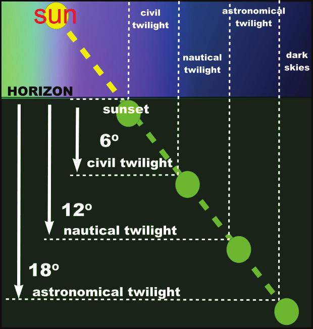
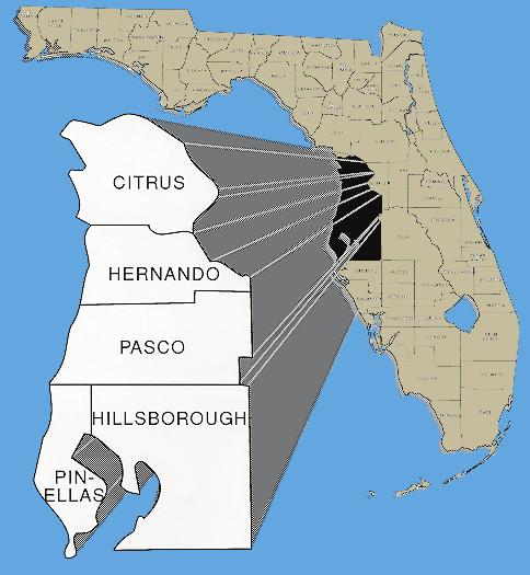
19 ID Roadway ID Road Name Length County Begin-Street End-Street US 41/SR Citrus Relief St Davidson Avenue US Citrus SE 8th Avenue NW 22nd St US Hernando SR 50 Lakeside Dr SR Hernando SR 50 US th St Hillsborough Adamo Dr E E Hillsborough Avenue Florida Avenue Hillsborough SR-60 Kennedy Blvd Nebraska Avenue Hillsborough Avenue Hillsborough Nebraska Avenue Orient Rd US 92 Reynolds St Hillsborough Thonotosassa Rd Park Rd US 92 Baker St Hillsborough Reynolds St Thonotosassa Rd Nebraska Avenue Hillsborough Kay St 142nd Avenue US Hillsborough 1st St SW Riverview Dr Kennedy Blvd Hillsborough Henderson Blvd Brevard Avenue E Frank Adamo Dr Hillsborough N 22nd St I Dale Mabry Hwy Hillsborough Gandy Blvd Hillsborough Avenue Courtney Campbell Cswy Hillsborough Pinellas County Line Rocky Point Dr Hillsborough Avenue Hillsborough Theresa Rd Nebraska Avenue Dale Mabry Hwy Hillsborough Hillsborough Avenue Veteran Expressway nd St Hillsborough N21st St Hillsborough Avenue st St Hillsborough I-4 Adamo Dr Kennedy Blvd Hillsborough Ward St Henderson Blvd Fowler Avenue Hillsborough Florida Avenue Morris Bridge Rd Busch Blvd Hillsborough Nebraska Avenue 56th St th St Hillsborough E21st Avenue Fowler Avenue MLK Jr. Blvd Hillsborough Dale Mabry Hwy Queen Palm Ave US Pasco Phoenix Avenue Gulf Highlands Dr S. Missouri Avenue Pinellas East Bay Dr Court St th Avenue N/Tyrone Blvd/Seminole Blvd Pinellas 4th St N East Bay Dr Alt US Pinellas Myrtle Avenue Orange St East Bay Dr Pinellas Seminole Blvd Ulmerton Rd Gulf to Bay Blvd Pinellas Highland Blvd Damascus Rd Drew St Pinellas N Myrtle Avenue Delaware St Gulf Blvd Pinellas Pinellas Bayway SR Passadena Avenue Pinellas Blinds Pass Rd Park St Ulmerton Rd Pinellas Gulf Blvd I Gulf Blvd Pinellas SR 666 Walsingham Rd US Pinellas 54th Avenue S Live Oak St Gandy Blvd/4th St Pinellas US 19 I-275 Total miles

20 Two-lanes undivided highway with fixed roadway lighting at one side


21 Four-lanes divided or undivided highway with fixed roadway lighting at two sides

22 Six-lanes divided highway or more with fixed roadway lighting at two sides


23
24 Roadway Classifications Interstate, Expressway, Freeway & Major Arterials TABLE Illumination Level Average Initial Horizontal Foot Candle (H.F.C.) UNIFORMITY RATIOS Avg./MIN. MAX./MIN :1 or Less 10:1 or Less All Other Roadways 1.0 4:1 or Less 10:1 or Less Pedestrian Ways & Bicycle Lanes 2.5 4:1 or Less 10:1 or Less Plans Preparation Manual, Volume 1 English (January 1, 2009)
25 9.00 Left Outer Left Inner 8.00 Illumination Level (fc) Milepost

26 9.00 Right Outer 8.00 Illumination Level (fc) Milepost Right Inner
27 Florida CARS System Day time / Dusk / Down Nighttime with lighting Nighttime without lighting Sunrise and Sunset data From U. S. Naval Observatory
28 12:00 AM 1:00 AM 2:00 AM 3:00 AM 4:00 AM 5:00 AM 6:00 AM 7:00 AM 8:00 AM 9:00 AM 10:00 AM 11:00 AM 12:00 PM 1:00 PM 2:00 PM 3:00 PM 4:00 PM 5:00 PM 6:00 PM 7:00 PM 8:00 PM 9:00 PM 10:00 PM 11:00 PM January February March April May June July August September October November December Dawn Day Dusk Night

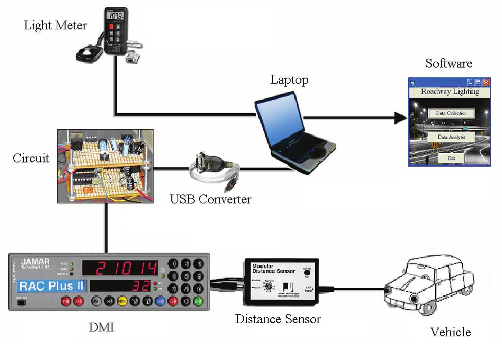
29 Accident location (milepost) Date (day/month/year) Day of week Time (hour) Accident severity (F/I/PDO) At intersection Intersection-related Driveway-related At railroad highway grade crossing Grade-crossing-related Speed-change lane Not related to junction Light condition Weather Pavement surface condition Number of vehicles involved Driver age Vehicle types involved First harmful event Most harmful event Object struck Ran-off road indicator (yes/no) Pedestrian indicator (yes/no) Bicycle indicator (yes/no)
30 Beginning and ending points - linkable to accident data Area type Number of lanes and width Auxiliary lanes (TWLTL/passing lane/other auxiliary lane) Median type and width Shoulder type and width Average daily and hourly traffic Percent heavy vehicles Posted Speed

31 Pair the crash data with the illuminance levels to perform an analysis to identify if exist a direct relationship. Identify the average illuminance level that is more appropriate.
32 This project was sponsored by the Florida Department of Transportation District 7 Jiguang Zhao


33 Enrique Gonzalez-Velez Graduate Research Assistant Center for Urban Transportation Research University of South Florida 4202 E. Fowler Avenue, CUT 100 Tampa, FL
Pinellas County Proposed Roadway Projects for the 2040 LRTP DRAFT %&g( %&g( Legend. SR686 Inset Map HILLSBOROUGH COUNTY.
 BELCHER RD 66TH ST N DRAFT 05-08-14 61 60 40 39 52 38 53 37 EAST LAKE RD KEYSTONE RD Pinellas County Proposed Roadway s for the 2040 LRTP Legend GULF BLVD 67 Gulf of Mexico WEST BAY DR WALSINGHAM RD µ
%&g( %&g( ) Bridge Projects DRAFT
 Bridge Projects DRAFT") BELCHER RD 66TH ST N DRAFT 09-18-14 GULF BLVD Dunedin Causeway 16 Gulf of Mexico WEST BAY DR WALSINGHAM RD Beckett Bridge 102ND AVE N 26 27 S MYRTLE AVE 113TH ST N EDGEWATER DR BAYSHORE BLVD S MISSOURI
BELCHER RD 66TH ST N DRAFT 09-18-14 GULF BLVD Dunedin Causeway 16 Gulf of Mexico WEST BAY DR WALSINGHAM RD Beckett Bridge 102ND AVE N 26 27 S MYRTLE AVE 113TH ST N EDGEWATER DR BAYSHORE BLVD S MISSOURI
APPENDIX E: CIP Maps
 APPENDIX E: CIP Maps 175 ALT 19 PARK ST 49TH ST N. EAST LAKE RD BEGINNING YEAR OF CONSTRUCTION: ALT 19 TARPON AVE KEYSTONE RD FY 2010 FY 2011 FY 2012 FY 2013 FY 2014 FY 2015 FY 2016 FY 2017 KLOSTERMAN
Store # Address2 City State Zip County Phone NW US HIGHWAY 441 ALACHUA FL ALACHUA W.
 Store # Address2 City State Zip County Phone 11244 15155 NW US HIGHWAY 441 ALACHUA FL 32615 ALACHUA 386 418 3785 7944 1201 W. STATE ROUTE 436 ALTAMONTE SPRINGS FL 32714 SEMINOLE 407 389 7353 9016 200 W
This article appeared in a journal published by Elsevier. The attached copy is furnished to the author for internal non-commercial research and
 This article appeared in a journal published by Elsevier. The attached copy is furnished to the author for internal non-commercial research and education use, including for instruction at the authors institution
Lighting Design. Debra A. Kennaugh, P.E. Lighting Design by Debra A. Kennaugh, P.E. A SunCam online continuing education course
 Lighting Design by Debra A. Kennaugh, P.E. www.suncam.com Copyright 2010 Debra A. Kennaugh Page 1 Table of Contents I. Introduction A. Objectives of Roadway Lighting B. Visibility Requirements II. III.
IMPACT OF MODERN HEADLAMPS ON THE DESIGN OF SAG VERTICAL CURVES. A Thesis Proposal by Madhuri Gogula
 IMPACT OF MODERN HEADLAMPS ON THE DESIGN OF SAG VERTICAL CURVES A Thesis Proposal by Madhuri Gogula Submitted to the Office of Graduate Studies of Texas A&M University in partial fulfillment of the requirements
PINELLAS COUNTY MPO FY 2013/ /18 TRANSPORTATION ALTERNATIVES (TA) PROGRAM PRIORITY LIST STATUS REPORT
 PROGRAM PRIORITY LIST STATUS REPORT") PINELLAS COUNTY FY 2013/14-2017/18 A City of Sexton Elementary School sidewalk along 19 th St. N. from 38 th Ave. N. to 52 nd Ave. N. N/A N/A Safe Routes to School received (see footnote 7) B Pinellas
PINELLAS COUNTY FY 2013/14-2017/18 A City of Sexton Elementary School sidewalk along 19 th St. N. from 38 th Ave. N. to 52 nd Ave. N. N/A N/A Safe Routes to School received (see footnote 7) B Pinellas
City of St. Petersburg Planning & Visioning Commission October 11, 2011
 Pinellas Alternatives Analysis Speakers Bureau City of St. Petersburg Planning & Visioning Commission October 11, 2011 Pinellas Alternatives Analysis Project Purpose A study identifying transit options
3.62 ACRES VACANT LAND
 3.62 ACRES VACANT LAND EXCLUSIVE LISTING 101-111 WHITAER ROAD LUTZ, FLORIDA 33549 OPPORTUNITY Approximately 3.62 acres of vacant land located south of 101-111 Whitaker Road, Lutz, FL. LOCATION The property
CONSTRUCTION PLANS FOR: MUNICIPAL BUILDING REHABILITATION SECTION 26, TOWNSHIP 31 SOUTH, RANGE 15 EAST PINELLAS COUNTY, FLORIDA TAMPA ROAD C1
 ROAD EAST SUNSINE SKYWAY CONSTRUCTION PLANS FOR: SECTION 26, TOWNSIP 31 SOUT, RANGE 15 EAST PINELLAS COUNTY, FLORIDA FLORIDA AVE TARPON AVE LAKE KEYSTONE ROAD LAKE KLOSTERMAN ROAD TARPON D R A W I N G
General Information 11A-1. A. General. B. Industry Outlook. Design Manual Chapter 11 - Street Lighting 11A - General Information
 Design Manual Chapter 11 - Street Lighting 11A - General Information 11A-1 General Information A. General Darkness brings increased hazards to users of urban streets because it reduces the distance they
State Road A1A North Bridge over ICWW Bridge
 Final Report State Road A1A North Bridge over ICWW Bridge Draft Design Traffic Technical Memorandum Contract Number: C-9H13 TWO 5 - Financial Project ID 249911-2-22-01 March 2016 Prepared for: Florida
San Antonio Wrong Way Driver Initiative
 San Antonio Wrong Way Driver Initiative Brian G. Fariello, P.E. Traffic Management Engineer- TransGuide San Antonio District- TxDOT brian.fariello@txdot.gov The San Antonio Wrong Way Driver Task Force
WSDOT LED Adaptive Roadway Lighting & Illumination Reform
 WSDOT LED Adaptive Roadway Lighting & Illumination Reform Keith Calais Signal and Illumination Engineer Western States Rural Transportation Technology Implementers Forum June 17-19, 2014 Yreka, CA 1 Each
INTERNALLY ILLUMINATED SIGN LIGHTING. Effects on Visibility and Traffic Safety United States Sign Council
 INTERNALLY ILLUMINATED SIGN LIGHTING Effects on Visibility and Traffic Safety 2009 United States Sign Council The Effects of Internally Illuminated On-Premise Sign Brightness on Nighttime Sign Visibility
Comparison of Safety Performance by Design Types at Freeway Diverge Areas and Exit Ramp Sections
 University of South Florida Scholar Commons Graduate Theses and Dissertations Graduate School 12-31-2010 Comparison of Safety Performance by Design Types at Freeway Diverge Areas and Exit Ramp Sections
Updated: April 7, 2016
 Updated: April 7, 2016 Hwy 36 to Lexington Ave. Add a lane in each direction Recommend a MNPASS Lane Several spot improvements to roadway included Concrete pavement Noise walls will be evaluated Replace
TCAG Annual Intersection Monitoring Program
 TCAG Annual Intersection Monitoring Program 2015 Intersection Monitoring Report Prepared by: Transportation Modeling Department August, 2015 Work Element 605.01 TABLE OF CONTENTS INTRODUCTION...1 PROJECT
Evaluation of the Cost Effectiveness of Illumination as a Safety Treatment at Rural Intersections
 Evaluation of the Cost Effectiveness of Illumination as a Safety Treatment at Rural Intersections F. Gbologah, A. Guin, M. Hunter, M.O. Rodgers Civil & Environmental Engineering & R. Purcell Middle Georgia
TRAFFIC ENGINEERING SAB3843. CHE ROS BIN ISMAIL and OTHMAN BIN CHE PUAN
 TRAFFIC ENGINEERING SAB3843 GEOMETRIC DESIGN OF ROADS CHE ROS BIN ISMAIL and OTHMAN BIN CHE PUAN SOME MAJOR ELEMENTS OF ROAD GEOMETRY: Horizontal alignment, Vertical alignment, Sight distances, Crosssection,
LOCATION: RIDGE AVENUE FROM LAKE STREET TO DEMPSTER STREET LENGTH: APPROXIMATELY 1075' 2-WAY STOP AT RIDGE AVENUE AND GREENWOOD STREET
 CLIENT: CITY OF EVANSTON CHRISTOPHER B. BURKE ENGINEERING, LTD. PROJECT: EXISTING STREET LIGHT EVALUATION 9575 W. Higgins Road, Suite 00 DATE STUDY PERFORMED: /17/2017 Rosemont, Illinois 001 CBBEL PROJECT
TEXAS SENATE MILES DESCRIPTION: WIDEN NB AND SB MAINLANES TO 3 LANES EACH DIRECTION TO: 0.25 MILES N. OF LOOP 20/FM 3464 IN
 Page 1 IH 35 0018-06-136 1.4 WIDEN NB AND SB MAINLANES TO 3 LANES EACH DIRECTION SHILOH ROAD TO: 0.25 N. OF LOOP 20/FM 3464 IN URBAN FREEWAY $6,000,000 $23,000,000 IH 35 0018-06-138 0.9 FOR THE CONST OF
PUBLICATION 213. Think Safety First
 PUBLICATION 213 (67 PA CODE, CHAPTER 212) Think Safety First Pub 213 (02-08) Appendix Appendix A - Temporary/Portable
HIGHWAY WORK ZONE DATA COLLECTION INSTRUMENT
 HIGHWAY WORK ZONE DATA COLLECTION INSTRUMENT Case ID: MI Date of Investigation Respondent Employer Information 1. Is the employer the primary contractor or a subcontractor working at the site? Victim Information
TCAG Annual Intersection Monitoring Program
 TCAG Annual Intersection Monitoring Program 2015 Intersection Monitoring Report Prepared by: Transportation Modeling Department August, 2015 Work Element 605.01 TABLE OF CONTENTS INTRODUCTION...1 PROJECT
Hwy 36 to Lexington Ave. Add a lane in each direction Recommend a MNPASS Lane Several spot improvements to roadway included Concrete pavement Noise
 Hwy 36 to Lexington Ave. Add a lane in each direction Recommend a MNPASS Lane Several spot improvements to roadway included Concrete pavement Noise walls will be evaluated 2 Approximate $200 million construction
GUIDELINES FOR GOOD EXTERIOR LIGHTING PLANS
 GUIDELINES FOR GOOD EXTERIOR LIGHTING PLANS Prepared by: The Dark Sky Society (http://www.darkskysociety.org/) These guidelines have been developed in consultation with lighting professionals (with experience
This page is intentionally left blank
 This page is intentionally left blank This page is intentionally left blank MnDOT Metro District Fact Sheet Mpls./St. Paul District Offices: Roseville-Water's Edge (HQ), Golden Valley, Oakdale mndot.gov/metro/
2040 Long Range Transportation Plan - Needs Assessment: Congestion Management Costs and Benefits Prepared For:
 2040 Long Range Transportation Plan - Needs Assessment: Congestion Management Costs and Benefits Prepared For: 601 East Kennedy Boulevard Tampa, FL 33602 Table of Contents 1.0 Introduction... 2 2.0 Technical
Roadway Glare & Reflection Technical Data
 PARAGLAS SOUNDSTOP noise barrier sheet Roadway Glare & Reflection Technical Data Technical Overview The purpose of this Technical Brief is to discuss reflective glare relative to PARAGLAS SOUNDSTOP noise
Guide Sign Policy for Secondary State Highways Edition
 Massachusetts Highway Department, Ten Park Plaza, Boston, MA 02116-3973 ` Guide Sign Policy for Secondary State Highways 2005 Edition Revised September 2005 1. PURPOSE The Massachusetts Highway Department
Diversion Analysis. Appendix K
 Appendix K Appendix K Appendix K Project Description The Project includes the potential closure of the eastbound direction ramp for vehicular traffic at Washington Street and University Avenue. In addition,
LA DOTD s Nighttime Standards for Construction Operations. Presented by: Tom Ervin Traffic Solutions, Inc.
 LA DOTD s Nighttime Standards for Construction Operations Presented by: Tom Ervin Traffic Solutions, Inc. NIGHTTIME CONSTRUCTION OPERATIONS (02/06) NIGHTTIME CONSTRUCTION OPERATIONS (02/06): Section 105,
The Missouri Department of Transportation is proposing to amend the state's five-year Statewide Transportation Improvement Program (STIP).
.") The Missouri Department of Transportation is proposing to amend the state's five-year Statewide Transportation Improvement Program (STIP). A 7-day public comment period regarding the amendment begins February
The Missouri Department of Transportation is proposing to amend the state's five-year Statewide Transportation Improvement Program (STIP). A 7-day public comment period regarding the amendment begins February
LOCATION: DODGE AVENUE FROM WASHINGTON STREET TO SEWARD STREET LENGTH: APPROXIMATELY 1350'
 CLIENT: CITY OF EVANSTON CHRISTOPHER B. BURKE ENGINEERING, LTD. PROJECT: EXISTING STREET LIGHT EVALUATION 9575 W. Higgins Road, Suite 00 DATE STUDY PERFORMED: 8/24/2017 Rosemont, Illinois 0018 CBBEL PROJECT
Exit 61 I-90 Interchange Modification Justification Study
 Exit 61 I-90 Interchange Modification Justification Study Introduction Exit 61 is a diamond interchange providing the connection between Elk Vale Road and I-90. Figure 1 shows the location of Exit 61.
King Mill Lambert DRI# 2035 Henry County, Georgia
 Transportation Analysis King Mill Lambert DRI# 2035 Henry County, Georgia Prepared for: The Alter Group, Ltd. Prepared by: Kimley-Horn and Associates, Inc. Norcross, GA Kimley-Horn and Associates, Inc.
Chapter 4a GUIDE SIGNS
 Sign Designs and Markings Manual (TEM 295-2) Chapter 4a GUIDE SIGNS DIRECTIONAL ( D sign code numbers) Revised January 20, 2012 Guide Signs Directional Page 4a-2 Sign Designs and Markings Manual (TEM 295-2)
Facility Design 11C-1. A. General. B. Design Process. Design Manual Chapter 11 - Street Lighting 11C - Facility Design
 Design Manual Chapter 11 - Street Lighting 11C - Facility Design 11C-1 Facility Design A. General The basic goal of street lighting is to provide patterns and levels of pavement luminance to provide a
EVALUATING AN ADAPTIVE SIGNAL CONTROL SYSTEM IN GRESHAM. James M. Peters, P.E., P.T.O.E., Jay McCoy, P.E., Robert Bertini, Ph.D., P.E.
 EVALUATING AN ADAPTIVE SIGNAL CONTROL SYSTEM IN GRESHAM James M. Peters, P.E., P.T.O.E., Jay McCoy, P.E., Robert Bertini, Ph.D., P.E. ABSTRACT Cities and Counties are faced with increasing traffic congestion
INNOVATIVE DEPLOYMENT OF DYNAMIC MESSAGE SIGNS IN SAFETY APPLICATIONS
 INNOVATIVE DEPLOYMENT OF DYNAMIC MESSAGE SIGNS IN SAFETY APPLICATIONS L.A. Griffin Director of Expressway Operations, Orlando-Orange County Expressway Authority 4974 ORL Tower Road Orlando, FL 32807 (407)
MEMORANDUM. Recommended Action Receive Commission input on approach, pole design options, and proposed next steps.
 MEMORANDUM TO: FROM: Tom Harmer, Town Manager Isaac Brownman, Public Works Director DATE: January 17, 2018 SUBJECT: Underground Project: Street Lighting Update Recommended Action Receive Commission input
Complete Streets & PPM to FDM Update
 Florida Department of TRANSPORTATION Complete Streets & PPM to FDM Update Derwood Sheppard, P.E. Design Standards Paul Hiers, P.E. Roadway Criteria State Roadway Design Office February 2017 - FTBA Construction
Maryland SHA LED Lighting. Brian Grandizio PE / Amol Ranade EIT
 Brian Grandizio PE / Amol Ranade EIT Introduction To Technology Roadway Lighting Application Comparison With HID Technology I-83 Pilot Study SHA Implementation Of LED Future Of LED Lighting Introduction
LED Fundamentals and Roadway Lighting. Javier Urrea / Steve Ekblad
 LED Fundamentals and Roadway Lighting Javier Urrea / Steve Ekblad March 28 th, 2013 1 Learning Objectives Basic lighting metrics important in the outdoor space. LCS, Photometric Report, Roadway classifications
Vulcan Materials Company - Sanger/Centerville Project, Fresno County - Traffic Impact Analysis
 3.0 TRAFFIC IMPACTS 3.1 TRIP GENERATION To assess the impacts that the project may have on the surrounding streets, the first step was to determine Project trip generation. Project trip generation is shown
Update on Traffic Results and Findings
 Los Angeles County Metropolitan Transportation Authority Update on Traffic Results and Findings presented to the Corridor Advisory Committee February 16, 2017 Traffic Presentation Topics 2 Traffic Volumes
MARVIN RD SE 31ST I-5 OLD PACIFIC HWY SE STEILACOOM RD SE MULLEN RD SE NISQUALLY INDIAN RESERVATION UV 510 YELM RAINIER RD SE 123RD AVE SE RAINIER
 P:\Transportation\RTP2030\Maps_Images\Map2-1.mxd Map 2-1: Capacity Projects, Thurston County, WA UV 8 12 LITTLEROCK RD SW HWY 8 173RD AVE SW OLD HWY 99 CONFEDERATED TRIBES OF THE CHEHALIS RESERVATION JAMES
APPENDIX GLOSSARY OF TERMS
 Accommodation: The process by which the eye adapts itself to varying quantities of light. Adaptation: The process by which the eye adapts itself to varying quantities of light. Arrangement: The repeating
SECTION EDITION - REVISION 2. Large Guide
 SECTION 4 0 EDITION - REVISION Large Guide March 017 (This page left intentionally blank) Guide Sign Design Guidelines Design Guidelines There are general guidelines to follow in the design of highway
TECHNICAL INFORMATION Traffic Template Catalog No. TT1
 Copyright 2016 by SIRCHIE All Rights Reserved. TECHNICAL INFORMATION Traffic Template Catalog No. TT1 INTRODUCTION Your SIRCHIE Traffic Template is a versatile police tool designed to make even the most
Money Bayou Outfall Relocation Project
 Permit Sketches and General Notes Money Bayou Outfall Relocation Project 76 & 768 State Road (SR) Port St. Joe, Florida 2456 Section 9, Township 9S, Range W Gulf County, Florida 29 4.8' N, 85 7.2' W APPLICANT
2015 GDOT PowerPoint. Title Page
 Cartersville MPO Regional Travel Demand Model Update Joint Policy Committee (PC) and Technical Coordinating Committee (TCC) Meeting May 20, 1 BACKGROUND Federal legislation requires Long-Range Transportation
Single Point Urban Interchange (SPUI) with Signals
 with Signals") 1 Single Point Urban Interchange (SPUI) with Signals Allows for concurrent left turns on Wurzbach Parkway and on NW Military Traffic Signal added on NW Military Hwy at Fairfield Bend/ Turnberry Way Large
1 Single Point Urban Interchange (SPUI) with Signals Allows for concurrent left turns on Wurzbach Parkway and on NW Military Traffic Signal added on NW Military Hwy at Fairfield Bend/ Turnberry Way Large
Evaluation of Roadside Wrong-Way Warning Systems with Different Types of Sensors
 Journal of Traffic and Transportation Engineering 4 (2016) 155-166 doi: 10.17265/2328-2142/2016.03.004 D DAVID PUBLISHING Evaluation of Roadside Wrong-Way Warning Systems with Different Types of Sensors
Your NAMI State Organization
 Your NAMI State Organization State: State Organization: Florida NAMI Florida NAMI Florida PO Box 961 Tallahassee, FL 32302 Phone: (850) 671-4445 Fax: (850) 671-5272 Email Additional Contact Info: info@namiflorida.org
FLORIDA HIGHWAY PATROL OFFICIAL PRESS RELEASE PRESS RELEASE APPROVED FOR PUBLIC RELEASE BY: Trooper Joe M. Sanchez Public Affairs Officers 11/2/2016 T
 FLORIDA HIGHWAY PATROL OFFICIAL PRESS RELEASE PRESS RELEASE APPROVED FOR PUBLIC RELEASE BY: Trooper Joe M. Sanchez Public Affairs Officers 11/2/2016 Troop E 11/02/2016 1:42 PM STATE ROAD 90 EB / SW 137
Community Design Standards
 In accordance with the Zoning Ordinance Update Adopted December 15, 2015 OUTDOOR LIGHTING Sections: 3.1 Purpose and Intent 3.2 Definitions 3.3 Lighting Plans Required 3.4 Outdoor Lighting Limits 3.5 3.1
Planarization & Routing Guide
 Metro Regional Centerlines Collaborative Planarization & Routing Guide Document: Version. Published: July 8, 25 Prepared and edited by: Matt Koukol, MRCC Project Technical Lead Ramsey County GIS Manager
OPAC Adaptive Engine Pinellas County Deployment
 OPAC Adaptive Engine Pinellas County Deployment Farhad Pooran Telvent Transportation North America Baltimore Regional Traffic Signal Forum May 25, 2011 Presentation Agenda Adaptive control systems - expected
The Shoppes at Forney Crossings
 F M 548 U.S. HWY 80 U.S. HWY 80 F M 688 F M 548 COOL SPRINGS F M 1641 F M 548 TROPHY BUGLE CALL PHESANT WHITE PORCH SPINAKER The Shoppes at Forney Crossings 18' 14'-8" 18' 15'-8 1 2 " 14' 7' 23'-0" 21'-0"
August 18, 2016 FS-1604A US 70 Improvements, Johnston County. VHB Engineering NC, P.C.
 August 18, 2016 FS-1604A US 70 Improvements, Johnston County VHB Engineering NC, P.C. Agenda Project Description and Location Purpose and Need Background Plans Local Plans Legislation Adjacent STIP Projects
Transport Canada Standard for LED Signal Modules at Highway/Railway Grade Crossings. TC E-14 (October 10, 2003)
") Transport Canada Standard for LED Signal Modules at Highway/Railway Grade Crossings TC E-14 (October 10, 2003) - 2 - PURPOSE The purpose of this standard is to provide the minimum performance requirements
Transport Canada Standard for LED Signal Modules at Highway/Railway Grade Crossings TC E-14 (October 10, 2003) - 2 - PURPOSE The purpose of this standard is to provide the minimum performance requirements
ANALYSIS OF FATAL TRAFFIC CRASH-REPORTING AND REPORTING-ARRIVAL TIME INTERVALS OF EMERGENCY MEDICAL SERVICES
 0 0 0 0 ANALYSIS OF FATAL TRAFFIC CRASH-REPORTING AND REPORTING-ARRIVAL TIME INTERVALS OF EMERGENCY MEDICAL SERVICES Jaeyoung Lee, Ph.D., Corresponding Author Assistant Professor & Safety Program Director
Retail Availabilities
 Tampa Bay Florida Availabilities FOR SALE OR LEASE Accelerating success. Properties for / Land Rate/ Price Properties for 1001 4th Street North St. Petersburg, FL 33701 650 SF 5,120 SF $15.00/SF, Triple
Arterial Connected Vehicle Test Bed Deployment and Lessons Learned
 ARIZONA CONNECTED VEHICLE PROGRAM Arterial Connected Vehicle Test Bed Deployment and Lessons Learned Faisal Saleem ITS Branch Manager & SMARTDrive Program Manager Maricopa County Department of Transportation
LIT-2. Lighting Philosophy
 GENERAL DESIGN GUIDELINES LIT-2. Lighting Philosophy LIT-2. Exterior Lighting Design July 2009 LIGHTING General Lighting Design Guidelines General Lighting Design Guidelines 1.0 Lighting Philosophy Lighting
Signal Performance Metrics Charlie Wetzel, PE, PTOE
 Signal Performance Metrics Charlie Wetzel, PE, PTOE County Traffic Engineer Seminole County Florida 1 Who is Seminole County? Small County located just north of Orange County and the City of Orlando Population:
Demolition of Ramp C (SN ): Westbound Ontario Street to Eastbound I-90/94) over I-90/94 (JF Kennedy Expressway)
: Westbound Ontario Street to Eastbound I-90/94) over I-90/94 (JF Kennedy Expressway)") I-90/94 (Kennedy Expressway) at Ohio Street Structure Replacement and Rehabilitation Section Number 0303-474HB-R D-91-177-09 Contract 60F63 Cook County, Region One, District One City of Chicago Project
I-90/94 (Kennedy Expressway) at Ohio Street Structure Replacement and Rehabilitation Section Number 0303-474HB-R D-91-177-09 Contract 60F63 Cook County, Region One, District One City of Chicago Project
TURNPIKE DESIGN HANDBOOK (TDH) DESIGN CRITERIA PART 2
 DESIGN CRITERIA PART 2") TURNPIKE DESIGN HANDBOOK (TDH) DESIGN CRITERIA PART 2 FLORIDA S TURNPIKE ENTERPRISE PRODUCTION DESIGN DEPARTMENT OCOEE, FL January 2018 May 2, 2018 Addendum #1 Introduction As part of the Turnpike s continuing
TURNPIKE DESIGN HANDBOOK (TDH) DESIGN CRITERIA PART 2 FLORIDA S TURNPIKE ENTERPRISE PRODUCTION DESIGN DEPARTMENT OCOEE, FL January 2018 May 2, 2018 Addendum #1 Introduction As part of the Turnpike s continuing
Straight Line Diagram. Perry 50. January 2019
 Straight Line Diagram Perry 50 January 2019 This document was produced by the Pennsylvania Department of Transportation (PENNDOT) as an internal management tool for State maintained highways and is not
CHAPTER 2C - PRELIMINARY DESIGN. General... 2C-1. Review of Work Load... 2C-2 Establishing Priorities... 2C-2
 SECTION 2C - 1 - PROJECT REVIEW CHAPTER 2C - PRELIMINARY DESIGN General... 2C-1 SECTION 2C - 2 - COORDINATING TIME SCHEDULES Review of Work Load... 2C-2 Establishing Priorities... 2C-2 SECTION 2C 3 - REVIEW
Agenda. Analysis Tool Selection and Mesoscopic Dynamic Traffic Assignment Models Applications:
 Four Case Studies Agenda Analysis Tool Selection and Mesoscopic Dynamic Traffic Assignment Models Applications: Traffic diversion caused by capacity reduction (Fort Lauderdale, FL) Impacts on traffic due
TABULATIONS SHOWING PROPOSALS ISSUED BY THE ALABAMA DEPARTMENT OF TRANSPORTATION TUESDAY, AUGUST 16, 2016 FOR SPECIAL LETTING AUGUST 26, 2016
 TABULATIONS SHOWING PROPOSALS ISSUED BY THE ALABAMA DEPARTMENT OF TRANSPORTATION TUESDAY, AUGUST 16, 2016 FOR SPECIAL LETTING AUGUST 26, 2016 The Asphalt Indexes for the Month of August 2016 are: ACI -
Appendix Traffic Engineering Checklist - How to Complete. (Refer to Template Section for Word Format Document)
") Appendix 400.1 Traffic Engineering Checklist - How to Complete (Refer to Template Section for Word Format Document) Traffic Engineering Checksheet How to Complete the Form June 2003 Version 3 Maintained
Appendix 400.1 Traffic Engineering Checklist - How to Complete (Refer to Template Section for Word Format Document) Traffic Engineering Checksheet How to Complete the Form June 2003 Version 3 Maintained
THE SCHOOL BUS. Figure 1
 THE SCHOOL BUS Federal Motor Vehicle Safety Standards (FMVSS) 571.111 Standard 111 provides the requirements for rear view mirror systems for road vehicles, including the school bus in the US. The Standards
Michigan Traffic Crash Facts Historical Perspective
 194-213 Michigan Traffic Crash Facts Statistics regarding street and highway accidents are so vital to any comprehensive understanding and treatment of the safety problem that their collection and analysis
HIGHWAY ENGINEERING MODULE-IV
 HIGHWAY ENGINEERING MODULE-IV 1 HIGHWAY DRAINAGE. 2 HILL ROAD 3 ROADSIDE DEVELOPMENT. 4 ROAD ADMINISTRATION AND FINANCE Prof. Ujjval J. Solanki DEPARTMENT OF CIVIL ENGINEERING, DARSHAN INSTITUTE OF ENGINEERING
daylight Spring 2014 College of Architecture, Texas Tech University 1
 daylight Spring 2014 College of Architecture, Texas Tech University 1 artificial light Spring 2014 College of Architecture, Texas Tech University 2 artificial light Spring 2014 College of Architecture,
DELINEATOR REFERENCE POINT 200' TYPICAL SPACING (YELLOW DELINEATORS) END OF MERGE LANE TAPER DELINEATOR REFERENCE POINT
 END OF MERGE LANE TAPER DELINEATOR REFERENCE POINT") 200' TYP. 600' < EACH SIDE BOTH ROADWAYS END OF MERGE LANE TAPER TYPICAL FOR ALL 2-LANE MERGES EXCEPT WHERE THERE IS A MERGE FROM THE RIGHT AND NO OFFSET IN THE THROUGH LANES END OF MERGE LANE TAPER 200'
200' TYP. 600' < EACH SIDE BOTH ROADWAYS END OF MERGE LANE TAPER TYPICAL FOR ALL 2-LANE MERGES EXCEPT WHERE THERE IS A MERGE FROM THE RIGHT AND NO OFFSET IN THE THROUGH LANES END OF MERGE LANE TAPER 200'
Tanasbourne/Sunset Hwy Location
 NOW LEASING Tanasbourne/Sunset Hwy Location Beaverton, Oregon 103,000 ADT (09) 21,112 ADT (11) Sunset Hwy/US 26 Cornell Rd Bethany Blvd 146 parking stalls 173rd Ave Five Oaks Middle School SITE Freeway
6.5+ Acres: Commercial Zoning Auto Dealership Entitled US 98 North - South of I-4
 US 98 North - South of I-4 2510 NOrth Florida Ave.,, FL Square Mall Park Center To Orlando Exit 32 Market Square To Tampa Griffin Rd. Audi Dealership Providence Road Office Furniture Depot Griffin Rd.
2017 Income Limits and Rent Limits Florida Housing Finance Corporation SHIP Program
 Alachua County 30% 13,650 16,240 20,420 24,600 28,780 32,960 37,140 41,320 Refer to HUD 341 373 510 667 824 980 (Gainesville MSA) 50% 22,750 26,000 29,250 32,450 35,050 37,650 40,250 42,850 45,430 48,026
Appendix D. Traffic Noise Analysis Report. I-94 St. Michael to Albertville Minnesota Department of Transportation
 Appendix D Traffic Noise Analysis Report I-94 St. Michael to Albertville Minnesota Department of Transportation Traffic Noise Analysis Report I-94 St. Michael to Albertville Project SP 8680-172 Report
WESTTOWN TOWNSHIP, CHESTER COUNTY, PA LIGHTING ORDINANCE
 WESTTOWN TOWNSHIP, CHESTER COUNTY, PA LIGHTING ORDINANCE 170-1514. Outdoor lighting. [Amended 3-3-2003 by Ord. No. 2003-2] A. Purpose. The purpose is to require and set standards for outdoor lighting to:
Appendix A. Congestion Management Process
 Appendix A Congestion Management Process CONGESTION MANAGEMENT PROCESS NORTHEASTERN INDIANA REGIONAL COORDINATING COUNCIL This report represents an update of the activities documenting the development
Legislative Joint Transportation Committee Meeting. Arkansas Convention Center Texarkana Thursday, November 21, 2013
 Arkansas State Highway and Transportation Department Legislative Joint Transportation Committee Meeting Arkansas Convention Center Texarkana Thursday, November 21, 2013 Recent Voter Approved Programs November
Huang Ke 1,2 *, Weng Ji 1 1 Faculty of Architecture and Urban Planning, Chongqing University, Chongqing,
 [Type text] [Type text] [Type text] ISSN : 0974-7435 Volume 10 Issue 23 BioTechnology 2014 An Indian Journal FULL PAPER BTAIJ, 10(23), 2014 [14269-14274] Contrast threshold research of small target visibility
Project: EIR for Carondelet High School Sports Complex
 Attachment 7 May 4, 2016 Project: EIR for Carondelet High School Sports Complex Prepared by: Ronald Zeiger, PE Scope of Project: The proposed outdoor sports lighting consists of the following: Soccer/lacrosse
FARM TO MARKET 1103 OPEN HOUSE PUBLIC MEETING. FM 1103 I-35 to Rodeo Dr
 FARM TO MARKET 1103 OPEN HOUSE PUBLIC MEETING March 29, 2016 FM 1103 FROM: I-35 TO: RODEO DR COMAL & GUADALUPE COUNTY OPEN HOUSE PUBLIC MEETING March 29, 2016 5:00 p.m. 7:00 p.m. Barbara C Jordan Intermediate
GUIDELINES FOR REDUCING WRONG-WAY CRASHES ON FREEWAYS
 GUIDELINES FOR REDUCING WRONG-WAY CRASHES ON FREEWAYS Prepared by: Huaguo Zhou, Ph.D., P.E. Mahdi Pour Rouholamin May 2014 Guidelines for Reducing Wrong-Way Crashes on Freeways Prepared by: Huaguo Zhou,
X X X X X X. ! Proposed Signalized HIGHWAY 55 PEDESTRIAN CROSSINGS
 HIGHWY 55 PEDESTRIN CROSSINGS» This graphic depicts walking distances to proposed signalized intersections along Olson Highway if existing unsignalized crossings are closed. Farwell Mpls College Prep Charter
ACE VENTURA ROUTE INSTRUCTIONS GROUPS R and X September 8, 2012
 ACE VENTURA ROUTE INSTRUCTIONS GROUPS R and X September 8, 2012 1 Please read the General Rules and Regulations carefully. Ask a rally worker for clarification if necessary. Drive safely and legally at
Straight Line Diagram. Forest 27. January 2019
 Straight Line Diagram Forest 27 January 2019 This document was produced by the Pennsylvania Department of Transportation (PENNDOT) as an internal management tool for State maintained highways and is not
Jointing Rural Intersections
 Design Manual Chapter 5 - Roadway Design 5G - PCC Pavement Joints 5G-4 Jointing Rural Intersections This section describes how to joint rural intersections by following the guidelines outlined in Iowa
Roadway Lighting and Visibility. Driver Issues. Motor Vehicle Crashes Magnitude of. the Problem. Motor Vehicle Crashes Magnitude of the Problem
 Roadway Lighting and Visibility Dr. Ronald B. Gibbons Group Leader, Lighting and Infrastructure Technology R A N K 1 2 3 4 5 6 Infants Top 10 Leading Causes of Death in the United States for 2001, by Motor
Straight Line Diagram. Lawrence 37. January 2018
 Straight Line Diagram Lawrence 37 January 2018 This document was produced by the Pennsylvania Department of Transportation (PENNDOT) as an internal management tool for State maintained highways and is
Straight Line Diagram. Columbia 19. January 2018
 Straight Line Diagram Columbia 19 January 2018 This document was produced by the Pennsylvania Department of Transportation (PENNDOT) as an internal management tool for State maintained highways and is
Straight Line Diagram. Jefferson 33. January 2018
 Straight Line Diagram Jefferson 33 January 2018 This document was produced by the Pennsylvania Department of Transportation (PENNDOT) as an internal management tool for State maintained highways and is