MARVIN RD SE 31ST I-5 OLD PACIFIC HWY SE STEILACOOM RD SE MULLEN RD SE NISQUALLY INDIAN RESERVATION UV 510 YELM RAINIER RD SE 123RD AVE SE RAINIER
|
|
|
- Alfred Perkins
- 6 years ago
- Views:
Transcription
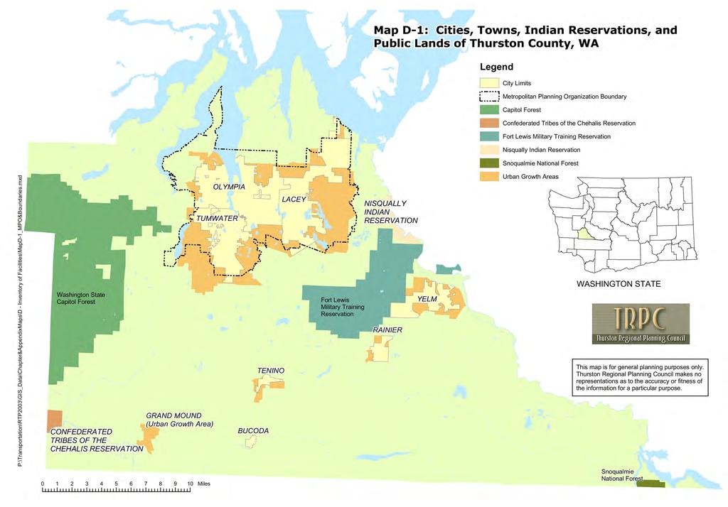
1 P:\Transportation\RTP2030\Maps_Images\Map2-1.mxd Map 2-1: Capacity Projects, Thurston County, WA UV 8 12 LITTLEROCK RD SW HWY 8 173RD AVE SW OLD HWY 99 CONFEDERATED TRIBES OF THE CHEHALIS RESERVATION JAMES RD SW PRATHER RD SW MIMA RD SW RD AVE SW SARGENT RD SW 41ST AVE NE DELPHI RD SW 7!(!( 22 MAYTOWN RD SW HWY 101 STEAMBOAT ISLAND RD NW GRAVELLY BEACH LP NW OVERHULSE RD NW BLACK LAKE BLVD SW COOPER PT RD NW ZANGLE RD NE 81ST AVE NW 46TH AVE NE 36TH AVE NW 36TH AVE NW WALNUT 20TH AVE NW 11TH AVE NWYEW ST. MUD BAY RD W HARRISON WAY BAY EAST STATE 26TH AVE NE ST. LIBBY RD NE MARTIN LILLY RD NE SLEATER-KINNEY RD NE WAY JOHNSON POINT RD NE PACIFIC 78TH AVE NW OLYMPIA !(!(!(!( !(!( LITTLEROCK RD SW 93RD AVE SW!( 27 TUMWATER TROSPER ST SW TIERNEY ST SW TILLEY RD S KIMMIE ST SW CASE RD SW 88TH AVE SE 101ST AVE SW 113TH AVE SE OLD HIGHWAY 99 SE CAPITOL NORTH ST. SOUTH ST.!( 6!( 29!( 5!( 20!( 19 UV 121 UV 143RD AVE SE 22ND BUCODA!(!( 18 31!(!( 10!( 24 OLD HIGHWAY 99 SE FONES SE. BOULEVARD YELM HWY SE RICH RD SE TENINO UV 507 TO NO RD SE!( 1 SKOOKUMCHUCK RD SE 63RD AVE NW LACEY!( 13!( 3!( 14 CARPENTER RD SE MARVIN RD SE!( 12!( 26!( 30!( 28!( 23!( 11!( 25 WALDRICK RD SE UV ST STEILACOOM RD SE MULLEN RD SE RAINIER RD SE 138TH AVE SE OLD PACIFIC HWY SE RAINIER NISQUALLY INDIAN RESERVATION VAIL CUT-OFF SE YELM 121 UV507 UV 510 UV 510 KOEPPEN RD SE 148TH AVE SE 123RD AVE SE!( 21 VAIL RD SE 153RD AVE SE 138TH AVE SE BALD HILL RD SE ID Project Agency SMITH PRAIRIE RD SE 1 One-Way Couplet Project Lacey 2 Sleater-Kinney/6th Ave Realignment Lacey 3 Yelm Highway Widening Lacey 4 4th/5th Avenue Corridor Bridge Project Olympia 5 Tumwater Boulevard and Bridge Widening Tumwater 6 Littlerock Road Widening Tumwater 7 Elderberry Road Upgrade Thurston Co. 8 Mud Bay Road Capacity Project 1 Thurston Co. 9 Harrison Avenue (Mud Bay Road) Widening, Phase II Olympia 10 Yelm Highway Capacity Project 1 Olympia & Thurston Co. 11 Carpenter Road Capacity & Safety Project Lacey 12 Marvin Road Widening Lacey 13 Rainier Road Widening Inside UGA Lacey 14 Yelm Highway Capacity Project 3 Lacey 15 Martin Way & Interchange Improvements, Phase 1 Lacey & WSDOT 16 Martin Way & Interchange Improvements, Phase 2 Lacey & WSDOT 17 Fones Road Widening, Phase 1 Olympia 18 18th Avenue (Fones Road) Widening, Phase 2 Olympia 19 Old Highway 99 Widening 1 Tumwater 20 Old Highway 99 Widening 2 Tumwater 21 Yelm Avenue West Widening Yelm 22 Old Highway 99 Rural Capacity Project Thurston Co. 23 Pacific Avenue Capacity Project Thurston Co. 24 Rich Road Capacity Project Thurston Co. 25 Yelm Highway Capacity Project 4 Thurston Co. 26 Britton Parkway, Phase 2 Lacey 27 Black Lake Boulevard Widening Tumwater & Olympia 28 Carpenter Road Widening Lacey & Thurston Co. 29 Tumwater Boulevard Bridge Widening Tumwater 30 Marvin Road Interchange Phase 2 Lacey 31 Boulevard Road Corridor Project Olympia Note: For more project details see Table 2-2!( Capacity Projects Indian Reservations City Limits This map is for general planning purposes only. Thurston Regional Planning Council makes no representations as to the accuracy or fitness of the information for a particular purpose. Amended 6/1/ Regional Transportation Plan Thurston Regional Planning Council Miles 2-54 Source: TRPC Geographical Information System June 1, 2007
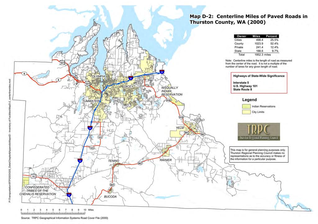
2 Map 2-2: New Connections or Alignments, Thurston County, WA P:\Transportation\RTP2003\Maps_Images\Map2-2.mxd UV 8 12 LITTLEROCK RD SW JAMES RD SW HWY 8 173RD AVE SW CONFEDERATED TRIBES OF THE CHEHALIS RESERVATION PRATHER RD SW OLD HWY 99 MIMA RD SW SARGENT RD SW 183RD AVE SW 41ST AVE NE DELPHI RD SW MAYTOWN RD SW HWY 101 STEAMBOAT ISLAND RD NW GRAVELLY BEACH LP NW!( 15 OVERHULSE RD NW BLACK LAKE BLVD SW COOPER PT RD NW ZANGLE RD NE 81ST AVE NW 46TH AVE NE 36TH AVE NW 36TH AVE NW WALNUT 20TH AVE NW 11TH AVE NWYEW ST. 101 MUD BAY RD W LITTLEROCK RD SW 93RD AVE SW OLYMPIA TROSPER ST SW HARRISON CAPITOL WAY BAY EAST STATE NORTH ST. SOUTH ST. 26TH AVE NE!(!(!(2 11 5!(!( 19 3!( 20!(!( 4 8!( 7 TUMWATER!( 14 UV 121 TIERNEY ST SW TILLEY RD S KIMMIE ST SW CASE RD SW 88TH AVE SE 101ST AVE SW 113TH AVE SE OLD HIGHWAY 99 SE!( 6 143RD AVE SE 22ND ST. BUCODA OLD HIGHWAY 99 SE LIBBY RD NE FONES SE. BOULEVARD MARTIN YELM HWY SE RICH RD SE TENINO UV 507 LILLY RD NE SLEATER-KINNEY RD NE T O NO RD SE WAY JOHNSON POINT RD NE PACIFIC SKOOKUMCHUCK RD SE 78TH AVE NW 63RD AVE NW LACEY!( 1 CARPENTER RD SE MARVIN RD SE WALDRICK RD SE!( 12!( 18 31ST STEILACOOM RD SE MULLEN RD SE!( 13 UV 507 RAINIER RD SE 138TH AVE SE OLD PACIFIC HWY SE RAINIER NISQUALLY INDIAN RESERVATION VAIL CUT-OFF SE YELM UV 510 KOEPPEN RD SE 148TH AVE SE 123RD AVE SE!(!( 17!( 10 16!(9 VAIL RD SE 153RD AVE SE ID Project Agency Related Projects 1 Mullen Road Extension Lacey 2 College St. NE Extension Lacey 3 Decatur Street Connection Olympia 4 Log Cabin Road Extension Olympia 5 Olympia Avenue Extension Olympia 6 Runway 17/35 Roadway Modifications Port of Olympia, Tumwater, Thurston Co., & WSDOT 7 Tyee Drive Extension Tumwater 8 Trosper Road/ Interchange Improvements Tumwater 9 510/507 Loop - North Section (Y3) WSDOT and Yelm Table 2-9, O /507 Loop - South Section (Y2) Yelm and WSDOT Table 2-9, O11 11 Yauger Way Extension Olympia & WSDOT Table 2-9, O10 12 Hogum Bay Road Truck Route Lacey 13 Hawks Prairie Road Extension Lacey 14 New South Tumwater Connector Tumwater 15 Evergreen Parkway Repair and Upgrade The Evergreen State College 16 Stevens Avenue Connection (Y4) Yelm 17 Thurston Highlands "Tahoma Boulevard" Yelm 18 Lacey Haw ks Prairie Business District Corridors Lacey 19 Kaiser Road Connection Olympia 20 E Street Connection Tumw ater Note: Project #9 is included for illustrative purposes. This project is now lead by WSDOT and is also identified on Table 2-9 and Map 2-8 as project O TH AVE SE BALD HILL RD SE SMITH PRAIRIE RD SE Indian Reservations New Alignments or Connections City Limits This map is for general planning purposes only. Thurston Regional Planning Council makes no representations as to the accuracy or fitness of the information for a particular purpose. Amended 6/1/ Regional Transportation Plan Thurston Regional Planning Council Miles 2-55 Source: TRPC Geographical Information System June 1, 2007
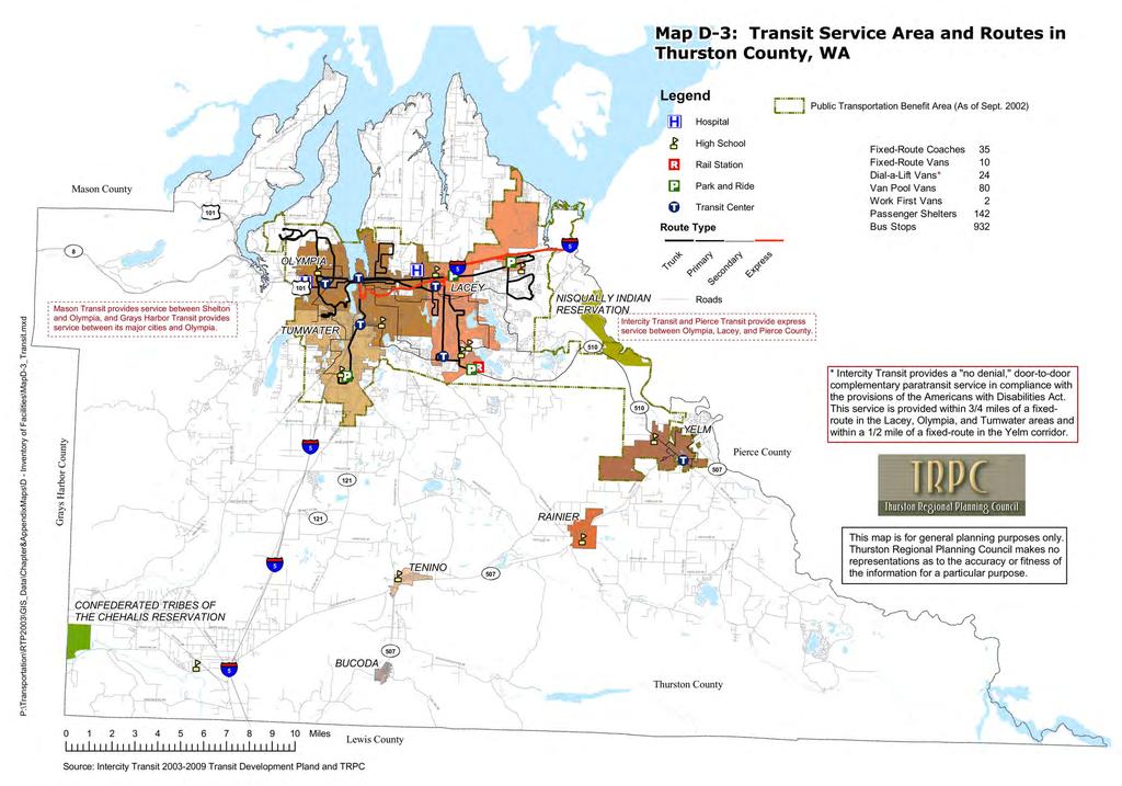
3 P:\Transportation\RTP2030\Maps_Images\Map2-3.mxd Map 2-3: Corridor Studies and Sub-Area Plans, Thurston County, WA UV 8 12 LITTLEROCK RD SW JAMES RD SW HWY 8 173RD AVE SW CONFEDERATED TRIBES OF THE CHEHALIS RESERVATION PRATHER RD SW OLD HWY 99 MIMA RD SW RD AVE SW SARGENT RD SW 41ST AVE NE 5 DELPHI RD SW MAYTOWN RD SW HWY 101 STEAMBOAT ISLAND RD NW GRAVELLY BEACH LP NW OVERHULSE RD NW BLACK LAKE BLVD SW COOPER PT RD NW ZANGLE RD NE 81ST AVE NW 46TH AVE NE 36TH AVE NW 36TH AVE NW WALNUT 20TH AVE NW OLYMPIA 11TH AVE NWYEW ST. 101 MUD BAY RD W LITTLEROCK RD SW 93RD AVE SW 4 TROSPER ST SW KIMMIE ST SW HARRISON TUMWATER 6 13 TIERNEY ST SW CASE RD SW 88TH AVE SE 101ST AVE SW 113TH AVE SE UV 121 UV TILLEY RD S 16 OLD HIGHWAY 99 SE CAPITOL WAY BAY EAST STATE NORTH ST. SOUTH ST. 143RD AVE SE 14 26TH AVE NE 22ND ST. BUCODA 2 OLD HIGHWAY 99 SE LIBBY RD NE FONES SE. BOULEVARD MARTIN YELM HWY SE RICH RD SE TENINO UV 507 LILLY RD NE SLEATER-KINNEY RD NE T O NO RD SE WAY JOHNSON POINT RD NE PACIFIC SKOOKUMCHUCK RD SE 78TH AVE NW 63RD AVE NW 15 LACEY CARPENTER RD SE MARVIN RD SE WALDRICK RD SE UV ST STEILACOOM RD SE MULLEN RD SE 8 RAINIER RD SE 138TH AVE SE OLD PACIFIC HWY SE RAINIER NISQUALLY INDIAN RESERVATION VAIL CUT-OFF SE YELM 121 UV507 UV 510 UV 510 KOEPPEN RD SE 148TH AVE SE 123RD AVE SE VAIL RD SE 153RD AVE SE 138TH AVE SE BALD HILL RD SE SMITH PRAIRIE RD SE ID Study Areas Agency Related Project 1 Carpenter Road Corridor Study Lacey 2 Boulevard Road Corridor Study Olympia 3 Carpenter Road Interchange Feasibility Study Lacey & WSDOT Table 2-9, O12 4 West Olympia Access Study (Yauger Way Extension, Phase 2) Olympia & WSDOT Table 2-9, O10 5 Grand Mound Transportation Study Thurston Co. 6 Custer Way Strategy Area Plan Tumwater 7 26th Avenue/31st Avenue Extension - Lacey & Thurston Co. Connection Study 8 Marvin Road Extension - Connection Study Lacey & Thurston Co. 9 Draham/15th Ave/12th Ave Extension Lacey, Olympia, & Feasibility Study Thurston Co th/15th Avenue Corridor Study Olympia & Thurston Co. 11 Rainier Road Extension - Connection Study Rainier & Thurston Co. 12 Ensign Connector/Hospital Access Study Olympia 13 Southwest Urban Area Sub-Area Plan Tumwater, Olympia, & Thurston Co. 14 Airport South Sub-Area Plan Tumwater, Port of Olympia, & Thurston Co. 15 College Street Corridor Study Lacey 16 Old Highway 99 Corridor Study Tenino 17 Reservation Road/SR510/Yelm Highw ay Feasibility Study 18 Regional High Capacity Transportation Study* TRPC Corridor Studies and Sub-Area Plans Indian Reservations City Limits Nisqually Indian Reservation and Thurston Co. * This is a region-w ide study and is therefore not identified on this map. Note: for more project details see Table 2-4 This map is for general planning purposes only. Thurston Regional Planning Council makes no representations as to the accuracy or fitness of the information for a particular purpose. Amended 6/1/ Regional Transportation Plan Thurston Regional Planning Council Miles 2-56 Source: TRPC Geographical Information System June 1, 2007
4 Map 2-4: Assessment Areas, Thurston County, WA 4 P:\Transportation\RTP2030\Maps_Images\Map2-4.mxd UV 8 12 LITTLEROCK RD SW JAMES RD SW HWY 8 173RD AVE SW CONFEDERATED TRIBES OF THE CHEHALIS RESERVATION PRATHER RD SW OLD HWY 99 MIMA RD SW RD AVE SW SARGENT RD SW 41ST AVE NE 5 DELPHI RD SW MAYTOWN RD SW HWY 101 STEAMBOAT ISLAND RD NW GRAVELLY BEACH LP NW 17 OVERHULSE RD NW BLACK LAKE BLVD SW 5 COOPER PT RD NW ZANGLE RD NE 81ST AVE NW 46TH AVE NE 36TH AVE NW 36TH AVE NW WALNUT 20TH AVE NW OLYMPIA 11TH AVE NWYEW ST. 101 MUD BAY RD W LITTLEROCK RD SW 93RD AVE SW TROSPER ST SW KIMMIE ST SW HARRISON TUMWATER 5 TIERNEY ST SW CASE RD SW 88TH AVE SE 101ST AVE SW 113TH AVE SE UV 121 UV TILLEY RD S OLD HIGHWAY 99 SE CAPITOL WAY BAY EAST STATE NORTH ST. SOUTH ST. 143RD AVE SE 26TH AVE NE 22ND ST. BUCODA OLD HIGHWAY 99 SE LIBBY RD NE FONES SE. BOULEVARD MARTIN YELM HWY SE RICH RD SE TENINO UV 507 LILLY RD NE SLEATER-KINNEY RD NE TO NO RD SE WAY JOHNSON POINT RD NE PACIFIC 5 SKOOKUMCHUCK RD SE 78TH AVE NW 63RD AVE NW LACEY CARPENTER RD SE MARVIN RD SE WALDRICK RD SE 1 UV ST STEILACOOM RD SE 5 MULLEN RD SE RAINIER RD SE 138TH AVE SE NISQUALLY INDIAN RESERVATION OLD PACIFIC HWY SE 3 15 RAINIER VAIL CUT-OFF SE YELM 121 UV507 5 UV 510 UV 510 KOEPPEN RD SE 148TH AVE SE 123RD AVE SE 17 VAIL RD SE 153RD AVE SE 138TH AVE SE 101 BALD HILL RD SE TUMWATER SMITH PRAIRIE RD SE OLYMPIA 14 UV Note: For more project details see Table LACEY ID Assessment Areas Agency 1 Rainier Road Thurston Co. 2 Rural Corridor Strategy (not mapped) Thurston Co. 3 Yelm Highway at Meridian Road Thurston Co. 4 Northeast Marvin Road Lacey 5 Southeast Marvin Road Lacey 6 College St NE & 15th Ave Lacey 7 Sleater-Kinney Road Lacey 8 Mullen Road/Log Cabin Extension Lacey & Olympia 9 North Henderson Boulevard Olympia 10 South Henderson Boulevard Tumwater 11 14th Avenue Access to Olympia 12 Plum Street Olympia 13 Hoffman Road/18th/14th Avenues Lacey & Olympia 14 Crosby Boulevard/US101 Interchange Tumwater, Olympia, & WSDOT 15 SR 510 Thurston Co. & WSDOT /507 Loop - North Section (Y3) Yelm & WSDOT 17 Mud Bay Road Assessment Area Thurston Co., Olympia, TRPC Amended 6/1/ Regional Transportation Plan Thurston Regional Planning Council Miles Source: TRPC Geographical Information System Legend Indian Reservations City Limits Assessment Areas This map is for general planning purposes only. Thurston Regional Planning Council makes no representations as to the accuracy or fitness of the information for a particular purpose June 1, 2007

5 2025 Regional Transportation Plan Thurston Regional Planning Council 2-58 June 1, 2007
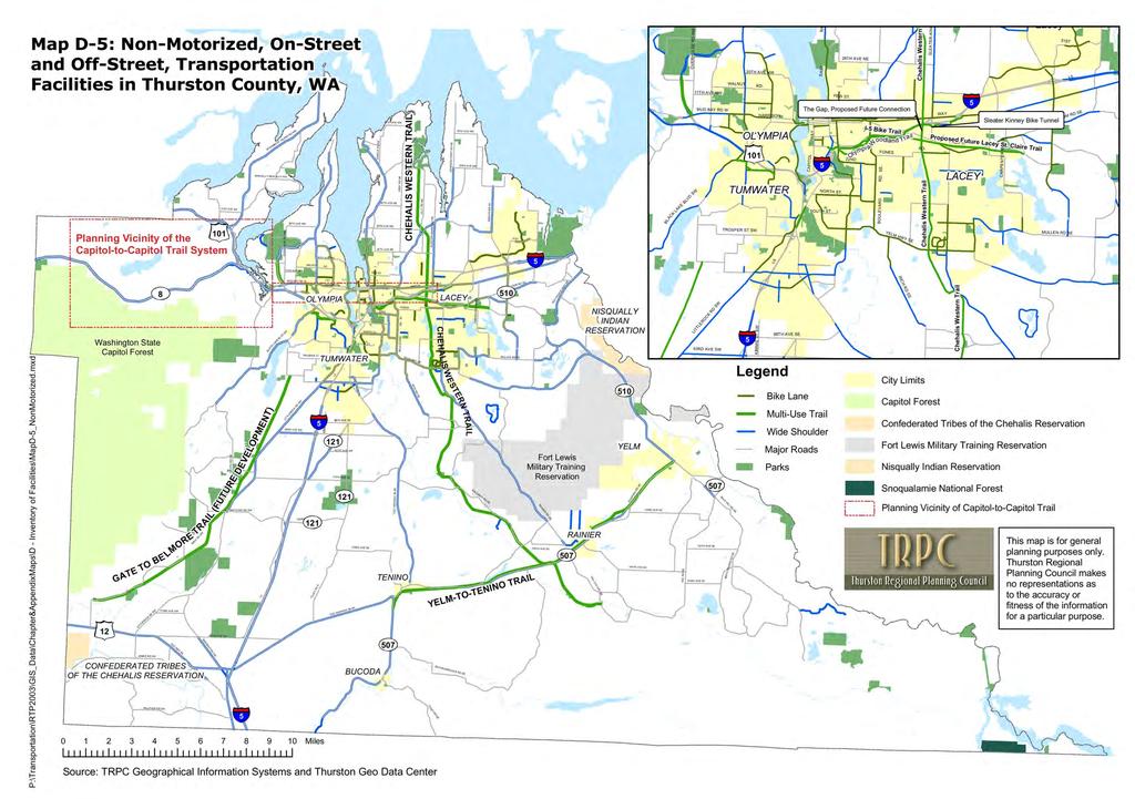
6 Integration of Capitol-to-Capitol Trail into the Regional Trails Plan: Identify ways of integrating the work that has already been done by WSDOT in developing the Capitol-to-Capitol Trails Plan into the broader Regional Trails Plan and Implementation Strategy 81ST AVE NE Map 2-6: 2025 Non-Motorized Transportation Projects, Thurston County, WA P:\Transportation\RTP2027\Maps_Images\Map2-6.mxd HWY 8 Washington State Capitol Forest!«5 MIMA RD SW GATE TO BEL MORE TRAIL CONFEDERATED TRIBES OF THE CHEHALIS RESERVATION LITTLEROCK RD SW JAMES RD SW UV 8 PRATHER RD SW 173RD AVE SW OLD HWY SARGENT RD SW 41ST AVE NE DELPHI RD SW MAYTOWN RD SW HWY 101 (FUTURE DEVELOPMENT) 183RD AVE SW STEAMBOAT ISLAND RD NW GRAVELLY BEACH LP NW MCLANE TRAIL OVERHULSE RD NW BLACK LAKE BLVD SW COOPER PT RD NW ZANGLE RD NE 46TH AVE NE 36TH AVE NW 36TH AVE NW WALNUT 20TH AVE NW 11TH AVE NWYEW ST. MUD BAY RD W LITTLEROCK RD SW 93RD AVE SW TROSPER ST SW HARRISON OLYMPIA TIERNEY ST SW Miles TUMWATER TILLEY RD S KIMMIE ST SW CASE RD SW 88TH AVE SE 101ST AVE SW 113TH AVE SE OLD HIGHWAY 99 SE CAPITOL WAY BAY EAST STATE NORTH ST. SOUTH ST. 143RD AVE SE BUCODA 26TH AVE NE 22ND ST.!«4 OLD HIGHWAY 99 SE LIBBY RD NE LILLY RD NE SLEATER-KINNEY RD NE JOHNSON POINT RD NE!«2!«1!«3 FONES SE. BOULEVARD TENINO Source: TRPC Geographical Information Systems and Thurston Geo Data Center UV 121 CHEHALIS WESTERN TRAIL MARTIN YELM HWY SE RICH RD SE T ONO RD SE WAY LACEY PACIFIC CHEHALIS WESTERN TRAIL SKOOKUMCHUCK RD SE 78TH AVE NE 63RD AVE NE CARPENTER RD SE MARVIN RD NE WALDRICK RD SE UV ST STEILACOOM RD SE MULLEN RD SE YELM-TO-TENINO TRAIL RAINIER RD SE 138TH AVE SE OLD PACIFIC HWY SE RAINIER UV 507 NISQUALLY INDIAN RESERVATION UV 121 UV 121 UV 507 UV 507 VAIL CUT-OFF SE UV 510 YELM KO EPPEN RD SE 148TH AVE SE 123RD AVE SE VAIL RD SE 153RD AVE SE 138TH AVE SE ID Project Agency Related Projects 1 Chehalis-Western Trail "Bridging the Gap" Thurston Co., Lacey, Project Olympia, & WSDOT 2 Olympia Woodland Trail Olympia BALD HILL RD SE 3 Lacey Woodland Trail Lacey 4 Regional Trails Plan & Implementation TRPC Strategy 5 Integration of Capitol-to-Capitol Trail into the Regional Trails Plan TRPC, WSDOT, Thurston Co., & Tumwater Note: For more project details see Table 2-7 SMITH PRAIRIE RD SE Legend!«Regionally Significant Non-Motorized Projects Major Roads City Limits Indian Reservations Capitol Forest Multi-Use Trails Regional Trails Plan and Implementation Strategy: Revisit the 1993 Urban Trails Plan and extend it region-wide. Develop a coordinated plan and implementation strategy for linking the region's various Class I bike facilities, providing thorough coverage to the region's urban and rural communities. Identify appropriate measures for integrating the region's Class I/ off-road trail system with its on-road facilities for bicyclists and pedestrians. Table 2-9, O8 This map is for general planning purposes only. Thurston Regional Planning Council makes no representations as to the accuracy or fitness of the information for a particular purpose Regional Transportation Plan Thurston Regional Planning Council 2-59 June 1, 2007
7 Map 2-7: 2025 WSDOT Projects, Thurston County, WA ID Project Agency Related Projects P:\Transportation\RTP2027\Maps_Images\Map2-7.mxd UV 8 12 LITTLEROCK RD SW CONFEDERATED TRIBES OF THE CHEHALIS RESERVATION JAMES RD SW HWY 8 PRATHER RD SW 173RD AVE SW OLD HWY 99 MIMA RD SW SARGENT RD SW 183RD AVE SW 41ST AVE NE! 3! 4 DELPHI RD SW 5 MAYTOWN RD SW HWY 101 STEAMBOAT ISLAND RD NW GRAVELLY BEACH LP NW! 1 OVERHULSE RD NW BLACK LAKE BLVD SW 5! 10 COOPER PT RD NW! 9 81ST AVE NW 78TH AVE NW ZANGLE RD NE JOHNSON POINT RD NE 46TH AVE NE 36TH AVE NW 36TH AVE NW WALNUT 20TH AVE NW 11TH AVE NWYEW ST. 101 MUD BAY RD W LITTLEROCK RD SW 93RD AVE SW OLYMPIA TROSPER ST SW TIERNEY ST SW KIMMIE ST SW HARRISON TUMWATER 5 UV 121 TILLEY RD S CASE RD SW 88TH AVE SE 101ST AVE SW 113TH AVE SE OLD HIGHWAY 99 SE CAPITOL WAY BAY EAST STATE NORTH ST. SOUTH ST. 143RD AVE SE 26TH AVE NE LIBBY RD NE! 5 22ND ST. BUCODA OLD HIGHWAY 99 SE FONES SE. BOULEVARD MARTIN YELM HWY SE TENINO UV 507 RICH RD SE! 8 63RD AVE NW LILLY RD NE SLEATER-KINNEY RD NE MARVIN RD SE TO NO RD SE WAY LACEY PACIFIC 5 SKOOKUMCHUCK RD SE CARPENTER RD SE WALDRICK RD SE! 12! 7 UV ST! 6 STEILACOOM RD SE MULLEN RD SE RAINIER RD SE 138TH AVE SE 5 NISQUALLY INDIAN RESERVATION OLD PACIFIC HWY SE RAINIER VAIL CUT-OFF SE! 2 YELM UV 510 KOEPPEN RD SE 148TH AVE SE 123RD AVE SE! 11 VAIL RD SE 153RD AVE SE! TH AVE SE BALD HILL RD SE SMITH PRAIRIE RD SE 1 Widening From Lewis County WSDOT to Maytown 2 SR 510 Widening WSDOT 3 Steamboat Island Interchange, WSDOT Stage 2 4 US 101/SR 8 Interchange WSDOT Retrofit 5 Corridor Mobility Study WSDOT 6 SR 507 Route Development Plan WSDOT Update 7 Regional Park-and-Ride WSDOT Investments 8 Chehalis-Western Trail "Bridging WSDOT Table 2-7, B1 the Gap" Project 9 Freeway Management System WSDOT Table 2-8, F1 10 West Olympia Access Study and Follow-Up Project WSDOT & Olympia Table 2-3, A11; Table 2-4, S /507 Loop-South Section (Y2) WSDOT & Yelm Table 2-3, A10 12 NE Lacey Access Study WSDOT & Lacey Table 2-4, S /507 Loop-North Section (Y3) WSDOT Note: For more project details see Table 2-9 Legend! Regionally Significant WSDOT Projects New Alignments or Connections City Limits Indian Reservations This map is for general planning purposes only. Thurston Regional Planning Council makes no representations as to the accuracy or fitness of the information for a particular purpose Regional Transportation Plan Thurston Regional Planning Council Miles Source: TRPC Geographical Information System 2-60 June 1, 2007
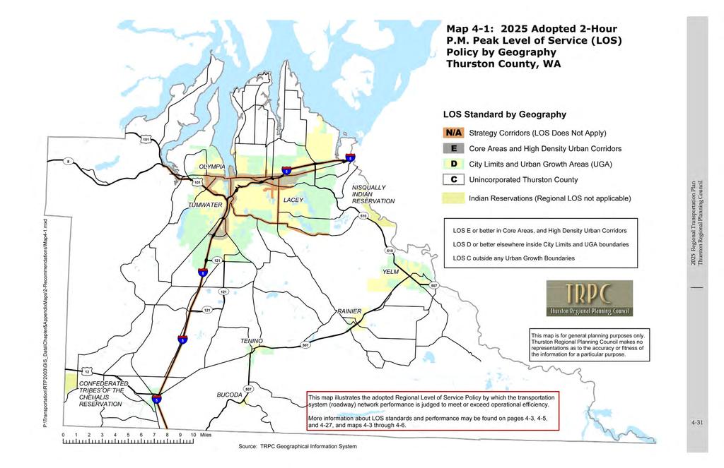
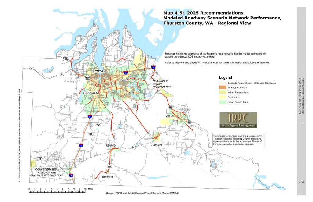
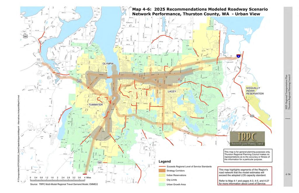
8 Map 2-8: Adopted 2-Hour P.M. Peak Level of Service (LOS) Policy by Geography Thurston County, WA P:\Transportation\RTP2030\Maps_Images\Map2-8.mxd UV 8 12 CONFEDERATED TRIBES OF THE CHEHALIS RESERVATION OLYMPIA TUMWATER Miles UV UV UV 121 RAINIER BUCODA TENINO UV 507 LACEY UV 507 NISQUALLY INDIAN RESERVATION UV 121 UV 510 UV 510 YELM LOS Standard by Geography N/A Strategy Corridors (LOS Does Not Apply) Core Areas and High Density Urban Corridors City Limits and Urban Growth Areas (UGA) Unincorporated Thurston County LOS E or better in Core Areas, and High Density Urban Corridors LOS D or better elsewhere inside City Limits and UGA boundaries LOS C outside any Urban Growth Boundaries This map illustrates the adopted Regional Level of Service Policy by which the transportation system (roadway) network performance is judged to meet or exceed operational efficiency. More information about LOS standards and performance may be found on pages 4-3, 4-5, and 4-27, and maps 4-1 and 4-3 through 4-6. E D C Indian Reservations (Regional LOS not applicable) This map is for general planning purposes only. Thurston Regional Planning Council makes no representations as to the accuracy or fitness of the information for a particular purpose. Amended 6/1/ Regional Transportation Plan Thurston Regional Planning Council 2-61 Source: TRPC Geographical Information System June 1, 2007
9
10
11
12
13
14
15
16
17
18
19
20
21
22
23
24
25
26
27

28
29
30
Permits Weekly Report
 19-100748-000-00-BA Status: Issued Create Date: 01/22/2019 Issue Date: 02/13/2019 Tax ID: 11719120100 Sub Code: Residence Stick Built Work Code: New Construction Site Location: 3125 96TH TRAIL SE, OLYMPIA
%&g( %&g( ) Bridge Projects DRAFT
 Bridge Projects DRAFT") BELCHER RD 66TH ST N DRAFT 09-18-14 GULF BLVD Dunedin Causeway 16 Gulf of Mexico WEST BAY DR WALSINGHAM RD Beckett Bridge 102ND AVE N 26 27 S MYRTLE AVE 113TH ST N EDGEWATER DR BAYSHORE BLVD S MISSOURI
BELCHER RD 66TH ST N DRAFT 09-18-14 GULF BLVD Dunedin Causeway 16 Gulf of Mexico WEST BAY DR WALSINGHAM RD Beckett Bridge 102ND AVE N 26 27 S MYRTLE AVE 113TH ST N EDGEWATER DR BAYSHORE BLVD S MISSOURI
Permits Weekly Report
 11-112650-000-00-BA Status: Issued Create Date: 11/07/2011 Issue Date: 01/03/2012 Tax ID: 21831310103 Sub Code: Accessory Structure Work Code: Addition Site Location: 9627 MULLEN RD SE, OLYMPIA R/T/S:
Pinellas County Proposed Roadway Projects for the 2040 LRTP DRAFT %&g( %&g( Legend. SR686 Inset Map HILLSBOROUGH COUNTY.
 BELCHER RD 66TH ST N DRAFT 05-08-14 61 60 40 39 52 38 53 37 EAST LAKE RD KEYSTONE RD Pinellas County Proposed Roadway s for the 2040 LRTP Legend GULF BLVD 67 Gulf of Mexico WEST BAY DR WALSINGHAM RD µ
THURSTON COUNTY ENVIRONMENTAL HEALTH DIVISION 2018 CERTIFIED SEWAGE SYSTEM INSTALLERS
 THURSTON COUNTY ENVIRONMENTAL HEALTH DIVISION 2018 CERTIFIED SEWAGE SYSTEM INSTALLERS 05-Apr-18 A / BELL EXCAVATING INC* Phone: (253) 896-0043 GREG APPLE (253) 536-3448 P O Box 731902 Puyallup, WA 98373
Appendix G. Visual Simulations and Illustrations
 Appendix G Visual Simulations and Illustrations 5TH AVE AV E N View ewshe ed 5 SHORELINE N 185TH ST egment B gment A 26 NE 185th Street Station (A1, A3, A5, A7, A10, A11) 25 24 23 22 21 NE 180TH ST 99
Hwy 36 to Lexington Ave. Add a lane in each direction Recommend a MNPASS Lane Several spot improvements to roadway included Concrete pavement Noise
 Hwy 36 to Lexington Ave. Add a lane in each direction Recommend a MNPASS Lane Several spot improvements to roadway included Concrete pavement Noise walls will be evaluated 2 Approximate $200 million construction
Attachment #2 PPW133-07
 Attachment #2 PPW133-07 Pg. 1 EXECUTIVE SUMMARY Environmental Assessment Study In January 2005, Regional staff retained to commence a Schedule C Environmental Assessment Study to identify the improvements
TEXAS SENATE MILES DESCRIPTION: WIDEN NB AND SB MAINLANES TO 3 LANES EACH DIRECTION TO: 0.25 MILES N. OF LOOP 20/FM 3464 IN
 Page 1 IH 35 0018-06-136 1.4 WIDEN NB AND SB MAINLANES TO 3 LANES EACH DIRECTION SHILOH ROAD TO: 0.25 N. OF LOOP 20/FM 3464 IN URBAN FREEWAY $6,000,000 $23,000,000 IH 35 0018-06-138 0.9 FOR THE CONST OF
The Missouri Department of Transportation is proposing to amend the state's five-year Statewide Transportation Improvement Program (STIP).
.") The Missouri Department of Transportation is proposing to amend the state's five-year Statewide Transportation Improvement Program (STIP). A 7-day public comment period regarding the amendment begins February
The Missouri Department of Transportation is proposing to amend the state's five-year Statewide Transportation Improvement Program (STIP). A 7-day public comment period regarding the amendment begins February
Phone: Address: 720 6th Street, Suite B, Clarkston, WA Web site:
 Adams Conservation District Phone: 509-659-1553 118 E. Main, Ritzville, WA 99169 chadamscd@hotmail.com http://www.adamscd.com/ Asotin County Conservation District Phone: 509-552-8117 720 6th Street, Suite
PORT SUSAN MIDDLE SCHOOL SPORTS SEASONS DIRECTIONS
 2014-2015 PORT SUSAN MIDDLE SCHOOL SPORTS SEASONS DIRECTIONS ANACORTES SCHOOLS Anacortes High School 1916 J. Ave. Anacortes, WA 98221 Take Hwy 20 to Anacortes. Take a right on Commercial. Take a left on
Appendix A Noise Monitoring Details
 Appendix A Noise Monitoring Details This page intentionally left blank. S 204 th Street Photo 2: Looking southeast from SR 99 Photo 3: Looking southwest Photo 4: Looking at the intersection of SR 99 and
Exit 61 I-90 Interchange Modification Justification Study
 Exit 61 I-90 Interchange Modification Justification Study Introduction Exit 61 is a diamond interchange providing the connection between Elk Vale Road and I-90. Figure 1 shows the location of Exit 61.
Appendix A Noise Monitoring Details
 Appendix A Noise Monitoring Details S 204 th St Photo 2: Looking southeast from SR 99 Photo 3: Looking southwest Photo 4: Looking at the intersection of SR 99 and S 204 th Street Monitoring Location M-1
Update on Traffic Results and Findings
 Los Angeles County Metropolitan Transportation Authority Update on Traffic Results and Findings presented to the Corridor Advisory Committee February 16, 2017 Traffic Presentation Topics 2 Traffic Volumes
Enrique Gonzalez-Velez Civil and Environmental Engineering University of South Florida
 Enrique Gonzalez-Velez Civil and Environmental Engineering University of South Florida Background Objective Introduction Roadway Lighting Literature Review Study Area Data Illuminance, Crash, and Roadway
Photo 4: Looking north
 S 308 th Ln Interstate 5 28th Avenue S Photo 2: Looking east toward I-5 Photo 3: Looking west toward 2833 S 308 th Ln Monitoring Location M-27A 2833 S 308th Lane (Home) Federal Way, Washington Photo 4:
APPENDIX IV-C. Glades County Critical Facilities Vulnerability Analysis
 APPENDIX IV-C Glades County Critical Facilities Vulnerability Analysis CHAPTER IV REGIONAL VULNERABILITY AND POPULATION ANALYSIS This page intentionally left blank. TABLE OF CONTENTS A. Introduction...
ACEC OC February 22, 2017
 ACEC OC February 22, 2017 I-405 Freeway 1958 I-405 Freeway Today Measure R Highway Projects Study Area Highway Program Project Status Summary (Measure R Funded) # Project Current Phase Estimated Cost of
Your NAMI State Organization
 Your NAMI State Organization State: State Organization: Address: Washington NAMI Washington NAMI Washington 1107 NE 45th St. Suite 230 Seattle, WA 98105 Phone: (206) 783-4288 Email Address: Executive Director:
IOWA ORNITHOLOGISTS' UNION - Birding Sites in Polk County
 IOWA ORNITHOLOGISTS' UNION - Birding Sites in Polk County Printed on 2/26/2019 Ashworth Park (ebird Hotspot) (Important Bird Area) GPS Coordinates: 41.5754971,-93.6830641 Ownership: City Big Creek SP (ebird
hauger bunch REALTOR 47+ Gross Acres / 33 Upland Acres Mixed Use / Office Sites US Highway 98 South Lakeland, Florida Polk State College
 47+ Gross Acres / 33 Upland Acres Mixed Use / Office Sites US Highway 98 South Lakeland, Florida Autumnwood Townhomes Polk State College Bramble Ridge Golf Course 47+ Gross Acres 33+ Upland Acres City
I-80 and Harrison Street
 Pay Pal Securities America Courtyard by Marriott Embassy Suites I-80 and Harrison Street Omaha, Nebraska For more information, please contact: Hampton Inn The Lerner Company Two Old Mill, Suite 270 10855
X X X X X X. ! Proposed Signalized HIGHWAY 55 PEDESTRIAN CROSSINGS
 HIGHWY 55 PEDESTRIN CROSSINGS» This graphic depicts walking distances to proposed signalized intersections along Olson Highway if existing unsignalized crossings are closed. Farwell Mpls College Prep Charter
Directions to GMC Middle School Game Sites (updated 8/20/13)
") Bridgetown Bridgetown Middle School, 3900 Race Rd, Cincinnati I-275 West to 74 East to Rybolt Rd, turn left. At Harrison Avenue, turn right and follow to Race Rd. and turn right. School is on the left.
Bridgetown Bridgetown Middle School, 3900 Race Rd, Cincinnati I-275 West to 74 East to Rybolt Rd, turn left. At Harrison Avenue, turn right and follow to Race Rd. and turn right. School is on the left.
Photo 1: Aerial View Photo 2: Looking northeast toward I-5. Michael Minor & Associates Sound.Vibration.Air Portland, Oregon
 Photo 2: Looking northeast toward I-5 Photo 3: Looking south Monitoring Location M-23 South 3001 S. 288th St. (223 Canterbury Drive in Camelot Square Mobile Home Park) Federal Way, Washington Photo 4:
County Training Program Class Schedule and Calendar July 2012 through June 2013
 July through June Purchasing Procedures for Counties August 8-9, Supervisory Skills I August 14-15, Basic Finance August 16-17, Basic Mapping August 23-24, Budget Process August 28-29, Managing Personnel
PINELLAS COUNTY MPO FY 2013/ /18 TRANSPORTATION ALTERNATIVES (TA) PROGRAM PRIORITY LIST STATUS REPORT
 PROGRAM PRIORITY LIST STATUS REPORT") PINELLAS COUNTY FY 2013/14-2017/18 A City of Sexton Elementary School sidewalk along 19 th St. N. from 38 th Ave. N. to 52 nd Ave. N. N/A N/A Safe Routes to School received (see footnote 7) B Pinellas
PINELLAS COUNTY FY 2013/14-2017/18 A City of Sexton Elementary School sidewalk along 19 th St. N. from 38 th Ave. N. to 52 nd Ave. N. N/A N/A Safe Routes to School received (see footnote 7) B Pinellas
6 YEAR TRANSPORTATION IMPROVEMENT PROGRAM
 YAKIMA COUNTY PUBLIC SERVICES DEPARTMENT 6 YEAR TRANSPORTATION IMPROVEMENT PROGRAM 2018 2023 COUNTY COMMISSIONERS J. Rand Elliott Ron Anderson Michael D. Leita DIRECTOR Vern M. Redifer, P.E. COUNTY ENGINEER
WSDOT LED Adaptive Roadway Lighting & Illumination Reform
 WSDOT LED Adaptive Roadway Lighting & Illumination Reform Keith Calais Signal and Illumination Engineer Western States Rural Transportation Technology Implementers Forum June 17-19, 2014 Yreka, CA 1 Each
OK Freewheel. Trail. Chisholm. All Route Maps and Cue Sheets (Day 0-7) June 11-17, Ponca City. Enid. Kingfisher. Chickasha. Duncan.
 June 11-17, Ponca City. Enid. Kingfisher. Chickasha. Duncan.") June 11-17, 2017 OK Freewheel Chisholm Trail South Haven, KS Enid Chickasha Comanche Ponca City Kingfisher Duncan Wichita Falls, TX Celebrating the 150th Anniversary of the Historic Chisholm Trail All
June 11-17, 2017 OK Freewheel Chisholm Trail South Haven, KS Enid Chickasha Comanche Ponca City Kingfisher Duncan Wichita Falls, TX Celebrating the 150th Anniversary of the Historic Chisholm Trail All
APPENDIX E: CIP Maps
 APPENDIX E: CIP Maps 175 ALT 19 PARK ST 49TH ST N. EAST LAKE RD BEGINNING YEAR OF CONSTRUCTION: ALT 19 TARPON AVE KEYSTONE RD FY 2010 FY 2011 FY 2012 FY 2013 FY 2014 FY 2015 FY 2016 FY 2017 KLOSTERMAN
BAY MEADOWS SPECIFIC PLAN
 BAY MEADOWS SPECIFIC PLAN Adopted by the San Mateo City Council April 22, 1997 Amended March 4, 2002, November 4, 2005 and January 4, 2010 BAY MEADOWS SPECIFIC PLAN Adopted by the San Mateo City Council
PATRICK AIRPORT CENTER
 CHARLESTON CAMPUS S RAINBOW BLVD N JONES BLVD N DECATUR BLVD S DECATUR BLVD MARYLAND PARKWAY N EASTERN AVE S PECOS ROAD S SANDHILL ROAD N HOLLYWOOD BLVD KYLE CANYON GATEWAY SPRING MOUNTAIN SILVERSTONE
King Mill Lambert DRI# 2035 Henry County, Georgia
 Transportation Analysis King Mill Lambert DRI# 2035 Henry County, Georgia Prepared for: The Alter Group, Ltd. Prepared by: Kimley-Horn and Associates, Inc. Norcross, GA Kimley-Horn and Associates, Inc.
RETAIL PADS AT THE PLANNED HIGHWAY 65 INTERCHANGE. SWC Whitney Ranch Parkway and Wildcat Boulevard, Rocklin California
 PLACER COUNTY PARCEL NUMBERS: Pad 1 (±1.554 Acres) GROUND LEASE OR BUILD-TO-SUIT Pad 2 (±1.432 Acres) GROUND LEASE OR BUILD-TO-SUIT Pad 3 (±2.315 Acres) GROUND LEASE OR BUILD-TO-SUIT Total Acres ±5.301
Active Temporary Disaster Debris Staging Sites
 BRUNSWICK TIMBER CREEK DS10-026 YW/LC 6 TIMBER CREEK LANE BALD HEAD ISLAND BRUNSWICK IKE WILLIAMSON SITE DS10-039 YW/LC/C&D ~2 ACRES SHALLOTTE OFF HALE SWAMPT RD (SR 1154) NE OF SHALLOTE AIRPORT BRUNSWICK
PATRICK AIRPORT CENTER
 CHARLESTON CAMPUS S RAINBOW BLVD N JONES BLVD N DECATUR BLVD S DECATUR BLVD MARYLAND PARKWAY N EASTERN AVE S PECOS ROAD S SANDHILL ROAD N HOLLYWOOD BLVD KYLE CANYON GATEWAY SPRING MOUNTAIN SILVERSTONE
PATRICK AIRPORT CENTER
 CHARLESTON CAMPUS S RAINBOW BLVD N JONES BLVD N DECATUR BLVD S DECATUR BLVD MARYLAND PARKWAY N EASTERN AVE S PECOS ROAD S SANDHILL ROAD N HOLLYWOOD BLVD KYLE CANYON GATEWAY SPRING MOUNTAIN SILVERSTONE
Timberland Bancorp, Inc.
 Timberland Bancorp, Inc. v ' l ^ l " ^ : --. " % '. " " : *, " -- - '.'^_ ' > i'.' ->.!.?., Silverdale Ocean Shores Hoquiam Auburn Edgewood Puyallup Gig Harbor Aberdeen (2 branches) Montesano Tacoma Yelm
Medicine Bow. National Forest. Columbine. Routt. National Forest. Steamboat. Springs. Eagle. White River. Glenwood. National Forest. Springs.
 T E L L E R BarnardDunkelberg Company U T A H 4 139 W Y O M I N G C O L O R A D O Rangely M O F F A T R I O B L A N C O G A R F I E L D 13 REGIONAL AIRPORT Rifle 70 Medicine Bow National Forest Routt National
Moorhead / Dilworth Fixed Route Expansion Study
 Moorhead / Dilworth Fixed Route Expansion Study Prepared for: MATBUS Prepared by: Fargo Moorhead Metropolitan Council of Governments April 2014 Introduction With growth in southeast Moorhead and Dilworth,
INDEX WIAA ATHLETIC CARDS
 WIAA ATHLETIC CARDS Green athletic cards are required whenever a student participates in a WIAA athletic sport. They must be signed by the physician. Green cards are good for two years, with the alternate
Updated: April 7, 2016
 Updated: April 7, 2016 Hwy 36 to Lexington Ave. Add a lane in each direction Recommend a MNPASS Lane Several spot improvements to roadway included Concrete pavement Noise walls will be evaluated Replace
Directions to Away Schools
 Directions to Away Schools BEAR CREEK PARK- Take I-25 to US 24 west (exit 141). Continue traveling west on US 24. Turn left on 21 st Street. Drive south for approximately 1.5 miles. Turn left on Rio Grande
Public School Facilities Element
 Public School Facilities Element GOAL 1: THROUGH PARTNERSHIPS AND EFFECTIVE COLLABORATION AMONG LOCAL GOVERNMENTS AND THE PINELLAS COUNTY SCHOOL DISTRICT, AND BECAUSE OF A SHARED COMMITMENT TO EDUCATIONAL
MIAMI, FL CO-WORKING LOCATIONS. cushwakesouthfl.com
 MIAMI, FL CO-WORKING LOCATIONS 08 cushwakesouthfl.com TABLE OF CONTENTS Northeast Dade Co-Working Locations - Biscayne Corridor Co-Working Locations - Wynwood CBD Miami Beach Co-Working Locations -8 Coral
Using Multimodal Performance Measures to Prioritize Improvements on US 101 in San Luis Obispo County
 Portland State University PDXScholar TREC Friday Seminar Series Transportation Research and Education Center (TREC) 4-24-2015 Using Multimodal Performance Measures to Prioritize Improvements on US 101
This page is intentionally left blank
 This page is intentionally left blank This page is intentionally left blank MnDOT Metro District Fact Sheet Mpls./St. Paul District Offices: Roseville-Water's Edge (HQ), Golden Valley, Oakdale mndot.gov/metro/
Planarization & Routing Guide
 Metro Regional Centerlines Collaborative Planarization & Routing Guide Document: Version. Published: July 8, 25 Prepared and edited by: Matt Koukol, MRCC Project Technical Lead Ramsey County GIS Manager
NATIONAL ORGS. National Agencies, Associations, & Organizations RESOURCE GUIDE: NATIONAL AGENCIES, ASSOCIATIONS, & ORGANIZATIONS
 National Agencies, Associations, & Organizations AIR Commercial Real Estate Association 500 North Brand Blvd., Suite 900 Glendale, CA 91203 Phone: (213) 687-8777 Web address: http://www.airea.com American
North Thurston Public Schools Fee Schedule Elementary Schools
 GENERAL FUND Olympic View Lakes Lydia Hawk Evergreen Forest Elementary Schools Lacey Mt. View Pleasant Glade South Bay Meadows Woodland Seven Oaks Horizons Chambers Prairie Field Trips Olympia Junior Programs
2015 GDOT PowerPoint. Title Page
 Cartersville MPO Regional Travel Demand Model Update Joint Policy Committee (PC) and Technical Coordinating Committee (TCC) Meeting May 20, 1 BACKGROUND Federal legislation requires Long-Range Transportation
Arkansas State Highway and Transportation Department
 Arkansas State Highway and Transportation Department Fayetteville Rotary Club Mermaids Restaurant Thursday, January 30, 2014 About AHTD The Facts: 12 th Largest System in USA 43 rd Highway Revenue Per
: Science to Local Policy Project Area Modeled Basins
 Map 1 Project Area Mason County cience to Local Policy Project Area Modeled Basins Black Lake oodard Pierce County Jurisdiction McLane Creek oodard Creek McLane LACEY Grays Harbor County Black Lake Note
3 Economic Development
 3 Economic Development Introduction: The Economic Development Element of the Comprehensive Plan is intended to guide the climate for enterprise and commercial exchange in Buckley and reinforce the overall
HOLIDAY HOP TO SOLVANG Saturday, Feb 17, 2001 Carpinteria to Solvang 63 Miles
 Saturday, Feb 17, 2001 Carpinteria to Solvang 63 Miles From Park and Ride Lot on Linden Av at 7 th St in Carpinteria, Northeast on LINDEN AV. 0.0 0.2 L----- 7 TH ST 0.2 0.5 R ---- SANTA YNEZ AV 0.7 0.2
Chapter 7. Figures. The following good practices can help to maximize the effectiveness of figures in NEPA documents:
 Examples of Effective Techniques for Improving the Quality of Environmental Documents Chapter 7. Figures Figures help to enhance readability by enabling a reader to visualize conditions that are described
STATEWIDE TRANSPORTATION IMPROVEMENT PROGRAM FY
 STATEWIDE TRANSPORTATION IMPROVEMENT PROGRAM FY 2008-2011 AMARILLO DISTRICT MARCH 20 TH OUT- OF - CYCLE REVISIONS 3-16-2009 file://d:\documents and Settings\LMOREL\Local Settings\Temp\XPgrpwise\49BE6199RS1H...
6.5+ Acres: Commercial Zoning Auto Dealership Entitled US 98 North - South of I-4
 US 98 North - South of I-4 2510 NOrth Florida Ave.,, FL Square Mall Park Center To Orlando Exit 32 Market Square To Tampa Griffin Rd. Audi Dealership Providence Road Office Furniture Depot Griffin Rd.
LAND FOR SALE DEVELOPMENT OPPORTUNITY. St. Louis, Missouri JUNE 2017
 LAND FOR SALE DEVELOPMENT OPPORTUNITY St. Louis, Missouri 63121 JUNE 2017 GWEN KNIGHT (D) +1 314 932 4096 (M) +1 314 422 0467 gwen.knight@colliers.com Table of Contents Offering Summary pg. 4-8 District
FOR SALE 8.24 ACRES. Development Site with Exceptional Freeway Visibility HADEN ONGARO RON REINKING COMMERCE BOULEVARD ROHNERT PARK // CA
 Development Site with Exceptional Freeway Visibility Wilfred Avenue 5300 COMMERCE BOULEVARD ROHNERT PARK // CA Golf Course Drive FOR SALE $8,300,000 $23/SF Commerce Boulevard Cascade Court COMMERCIAL/INDUSTRIAL
State Road A1A North Bridge over ICWW Bridge
 Final Report State Road A1A North Bridge over ICWW Bridge Draft Design Traffic Technical Memorandum Contract Number: C-9H13 TWO 5 - Financial Project ID 249911-2-22-01 March 2016 Prepared for: Florida
Route Stop Locations
 Route Locations : PR 70 AM 44:47 17.74 14-16 Marianne Simonson 7:30 am RIDGELINE MIDDLE SCHOOL 7:45 am (1) 14628 LAWRENCE LAKE RD SE/17028 153RD AVE SE 7:46 am (2) 14726 LAWRENCE LK RD SE 7:46 am (3) 14709
Washington Page 1 QUILT HARBOR 208 SOUTH BROADWAY ST. ABERDEEN WA
 QUILT HARBOR 208 SOUTH BROADWAY ST. ABERDEEN WA 98520 360-532-1200 4214 WHEATON WAY BREMERTON WA 98310 360-479-4214 NANA S QUILT SHOP 318 W MAPLE ALMIRA WA 99103 509-639-2648 OVER THE RAINBOW 740 MICHAEL
I-20 East Texas Corridor Implementation Plan DALLAS DISTRICT Updated May Install cable barrier system in median
 I-20 East Texas Corridor Implementation Plan DALLAS DISTRICT Updated May 2016 AE-1 Median Barrier I-635 to Kaufman County Line AF-1 Lawson Road to Kaufman County Line Install cable barrier system in median
Demolition of Ramp C (SN ): Westbound Ontario Street to Eastbound I-90/94) over I-90/94 (JF Kennedy Expressway)
: Westbound Ontario Street to Eastbound I-90/94) over I-90/94 (JF Kennedy Expressway)") I-90/94 (Kennedy Expressway) at Ohio Street Structure Replacement and Rehabilitation Section Number 0303-474HB-R D-91-177-09 Contract 60F63 Cook County, Region One, District One City of Chicago Project
I-90/94 (Kennedy Expressway) at Ohio Street Structure Replacement and Rehabilitation Section Number 0303-474HB-R D-91-177-09 Contract 60F63 Cook County, Region One, District One City of Chicago Project
TCAG Annual Intersection Monitoring Program
 TCAG Annual Intersection Monitoring Program 2015 Intersection Monitoring Report Prepared by: Transportation Modeling Department August, 2015 Work Element 605.01 TABLE OF CONTENTS INTRODUCTION...1 PROJECT
PNWRCC Job List - North Puget Sound Carpenters (LU 70) - Nov Job List - WWAN
 - Nov Job List - WWAN") PNWRCC Job List - North Puget Sound Carpenters (LU 70) - Nov 2017 Job List - WWAN PROJECT: WWU - Carver Academic Reno ADDRESS: 516 High Street, Bellingham, WA 98225 VALUE: PROJECT STAGE(S): Site Work /
PNWRCC Job List - North Puget Sound Carpenters (LU 70) - Nov 2017 Job List - WWAN PROJECT: WWU - Carver Academic Reno ADDRESS: 516 High Street, Bellingham, WA 98225 VALUE: PROJECT STAGE(S): Site Work /
Locate Request Information
 Locate Request Information NOTE: DO NOT USE any apostrophes ( )or quotation marks ( ) in Web Ticket Entry. Doing so may hamper the transmission of tickets to the utilities and locators. Limit per Ticket
GILBERT REAL ESTATE & PROPERTY MANAGEMENT 2407 Chambliss Avenue NW, Cleveland, TN / Phone PP\
 APARTMENTS BR BATH RENT DEPOSIT DESCRIPTION 3236 Weeks Horizon Dr NE 3 3 1250 1000 Townhouse, all app, ch/a, wd hook-up *no smoking 3212 / 3218 Weeks Horizon Dr NE 2 2 1050 1000 All app, ch/a, wd hook-up,
Start at Budget Inn, 1001 Olive St, San Luis Obispo, CA Control open 05:00-06:00. Exit right on Olive St.
 California Coasting 400k. Emergency call Terry Hutt 909.362.0956 Dist Type Next Note 0.0 0.1 Start at Budget Inn, 1001 Olive St, San Luis Obispo, CA 93405. Control open 05:00-06:00. Exit right on Olive
DE 8 Concept Plan and Operations Study. City of Dover Safety Advisory and Transportation Committee Meeting December 1, 2008
 DE 8 Concept Plan and Operations Study City of Dover Safety Advisory and Transportation Committee Meeting December 1, 2008 Purpose Develop a concept plan describing the aesthetic qualities of the corridor
WAUKEE MARKETPLACE A H U R D D E V E L O P M E N T RICHIE HURD RICHARD HURD DANIEL HURD
 A H U R D D E V E L O P M E N T S W C O R N E R O F H I C K M A N R D. & A L I C E ' S R D. W A U K E E, I A 5 0 2 6 3 RICHIE HURD RICHARD HURD DANIEL HURD V I C E P R E S I D E N T P R E S I D E N T V
CHIPPEWA FALLS. Chippewa Falls High School 735 Terrill Street Chippewa Falls WI 54729
 CHIPPEWA FALLS Four of the schools in Chippewa Falls are located within a 4-block radius, please use the basic instructions for the Chippewa Falls High School to get to these four schools: Chippewa Falls
LCRA TRANSMISSION SERVICES CORPORATION
 UCRA ENEtGY WATER COMMUNfnf SEEVICES LCRA TRANSMISSION SERVICES CORPORATION April 28, 2016 «FirstName» «LastName» «Suffix» «SecondName» «Address1» «Address2» «Address3» «City», «State» «Zip» RE: Application
A-MALL SHOPPING CENTER 1205 EAST SAHARA AVENUE LAS VEGAS, NV 89104
 MAJOR RENOVATIONS UNDERWAY RESTAURANT S RAINBOW BLVD N DECATUR BLVD VALLEY VIEW ROAD N EASTERN AVE S PECOS ROAD PROVIDENCE ELKHORN SPRINGS FOR LEASE > $1.25 - $1.50 PSF ($0.37 NNN) PAINTED DESERT LOS PRADOS
CTA Blue Line Forest Park Branch Feasibility/Vision Study
 CTA Blue Line Forest Park Branch Feasibility/Vision Study Overview of the Blue Line Feasibility / Vision Study!! PURPOSE! Determine long-term vision! Coordinate transit & highway improvements!! PROCESS!
Woodland School District - Proposed Board Districts as Approximated Using Census 2010 Geography Blue Lk. Lewis Riv. Lewis Riv.
 Woodland School - Blue Lk 1st 2nd Mc Bride Lk 3rd 4th Merrill Lk 5th Lew Yale Lk Riv Riv Lk Riv Lk YaleRiv Riv Riv Lk Merwin Lk Merwin Siouxon Crk Riv Riv e Lk Slough e Martin Lk Riv Burke Slough Riv Lk
Welcome Public Open House
 Peachland Study Welcome Public Open House Preliminary Review of Alternate & Existing Route Options Peachland Study Open House Purpose & Objectives 1. Present possible options for meeting the current and
Participant Statistical Areas Program for the 2010 Census. Vince Osier COPAFS Quarterly Meeting Washington, DC December 8, 2006
 Participant Statistical Areas Program for the 2010 Census Vince Osier COPAFS Quarterly Meeting Washington, DC December 8, 2006 1 Participant Statistical Areas Census Tracts Block Groups Census County Divisions
Branch Locations. Branch Address City State Zip State Code MSA County Code Census Tract County Name Census Designation Lobby Hours Drive-Thru Hours
 Multi-State MSA Omaha Council Bluffs (NE-IA) Plaza 1620 Dodge Street Omaha NE 68102 31 36540 055 0016.00 Douglas Middle M-F 7:45-5:00 24th & Oak 2930 S. 24th Street Omaha NE 68108 31 36540 055 0020.00
GREEN HILLS REGIONAL TRNASPORTION NEEDS ASSESSMENT CURRENT EFFECTIVE DATE JANUARY Produced by The Green Hills Regional Planning Commission
 GREEN HILLS REGIONAL TRNASPORTION NEEDS ASSESSMENT CURRENT EFFECTIVE DATE JANUARY 2009 Produced by The Green Hills Regional Planning Commission 1 County: Caldwell Source: RTP Needs Assessment 06 Rt: US
GILBERT REAL ESTATE & PROPERTY MANAGEMENT 2407 Chambliss Avenue NW, Cleveland, TN / Phone PP\
 APARTMENTS BR BATH RENT DEPOSIT DESCRIPTION 3221 Weeks Horizon Dr NE *3236 3 3 1250 1000 Townhouse, all app, ch/a, wd hook-up *no smoking 3212 Weeks Horizon Dr NE *3218 2 2 1050 1000 All app, ch/a, wd
Noise Study Report. Addendum. Interstate 10 Corridor Project. In the Counties of San Bernardino and Los Angeles
 Interstate 10 Corridor Project Draft NSR Addendum Noise Study Report Addendum Interstate 10 Corridor Project In the Counties of San Bernardino and Los Angeles 07-LA-10 PM 44.9/48.3 08-SBD-10 PM 0.0/R37.0
WAUKEE MARKETPLACE A H U R D D E V E L O P M E N T RICHIE HURD RICHARD HURD DANIEL HURD
 A H U R D D E V E L O P M E N T H I C K M A N R O A D & A L I C E ' S R O A D W A U K E E, I A 5 0 2 6 3 RICHIE HURD RICHARD HURD DANIEL HURD V I C E P R E S I D E N T P R E S I D E N T V I C E P R E S
ONLINE MAPPING PROJECT How to Use the Online Historical Maps of Snohomish County
 ONLINE MAPPING PROJECT - 2017 How to Use the Online Historical Maps of Snohomish County The mapping system available throughout LOSCHO is extremely powerful designed to allow the user to answer virtually
TCAG Annual Intersection Monitoring Program
 TCAG Annual Intersection Monitoring Program 2015 Intersection Monitoring Report Prepared by: Transportation Modeling Department August, 2015 Work Element 605.01 TABLE OF CONTENTS INTRODUCTION...1 PROJECT
FM 691 CORRIDOR STUDY
 FM 691 CORRIDOR STUDY Transportation Policy Board Meeting August 13, 2008 Agenda Project Overview US 75/FM 691 Interchange US 75 Ramping Alternatives FM 691 Corridor Typical Sections Extension to SH 289
a. Experience in providing services to school districts and other governmental
 Response of Kawahara Law, a Professional Corporation to the West Contra Costa Unified School District s Request for Qualifications for Special Counsel to the Board of Education A. Background Information
San Antonio Wrong Way Driver Initiative
 San Antonio Wrong Way Driver Initiative Brian G. Fariello, P.E. Traffic Management Engineer- TransGuide San Antonio District- TxDOT brian.fariello@txdot.gov The San Antonio Wrong Way Driver Task Force
BRIDGEPORT COMMUNITY HEALTH CENTER 471 Barnum Avenue Bridgeport, CT /
 The following is a list of Community Health Centers in Connecticut. They provide comprehensive, family-oriented, culturally competent medical, dental and social services to the uninsured and underinsured.
[LLOR L DP0000.LXSSH X.HAG ] Notice of Availability of the Draft Resource Management Plan/Environmental
![[LLOR L DP0000.LXSSH X.HAG ] Notice of Availability of the Draft Resource Management Plan/Environmental](/thumbs/94/120345586.jpg "[LLOR L DP0000.LXSSH X.HAG ] Notice of Availability of the Draft Resource Management Plan/Environmental") This document is scheduled to be published in the Federal Register on 10/05/2018 and available online at https://federalregister.gov/d/2018-21629, and on govinfo.gov 4310-33 DEPARTMENT OF THE INTERIOR
This document is scheduled to be published in the Federal Register on 10/05/2018 and available online at https://federalregister.gov/d/2018-21629, and on govinfo.gov 4310-33 DEPARTMENT OF THE INTERIOR
Linn County Sheriff s Foreclosure Sales
 Linn County Sheriff s Foreclosure Ses All ses are open to the public and will be conducted at 10:00 a.m. on the indicated date at the Linn County Sheriff's Office, 310 2 nd Ave SW, Cedar Rapids, IA. See
Pend Oreille County Current Road Restrictions
 5th St Stage 3 0.472 0.926 Usk Bridge to Leclerc Rd North/Leclerc Rd South/Kings Lake Rd Acre Dr Stage 3 0.000 0.480 Loren St to Alberta Rd Alberta Rd Stage 3 0.010 0.230 Amy St to Joyner Dr East Allen
CITY FOUNDRY ST. LOUIS 2
 CITY FOUNDRY ST. LOUIS 2 PROUDLY LOCATED IN SAINT LOUIS A Midwestern gem with a legacy of leadership. 1st Most Affordable City for Young Professionals Bloomberg 1st Fastest Growing Startup Scene Forbes
Available Office Space Summary
 BELLEVUE CBD 3725 9th Street Medical Center 11011 NE 9th Street 10,000 100,000 - $1.00 Bellevue CBD medical office building development. 100,000 SF available for condominium purchase or lease. Divisible
VICINITY MAP SCALE 1'' = 2000'
 LOCATED IN THE SOUTHWEST QUARTER OF SECTION AND THE WEST HALF OF SECTION 4, TOWNSHIP SOUTH, RANGE 68 WEST OF THE 6TH PRINCIPAL MERIDIAN, SHEET OF 5 E47 TOLL ROAD CASE NO. ZAX 26-4 LEGAL DESCRIPTION: A
AGENDA Planning Review Committee Pinellas County Planning Department 310 Court Street, 1 st Floor Conference Room 119 April 8, :00 A.M.
 AGENDA Planning Review Committee Pinellas County Planning Department 310 Court Street, 1 st Floor Conference Room 119 April 8, 2013 10:00 A.M. Case Summary Review: 1. CU-3-1-13 Berati # 2, LLC 2. Z/LU/CU-7-3-13