New Techniques in Binder Property Measurement
|
|
|
- Bryce Lynch
- 6 years ago
- Views:
Transcription

1 Pie in the Sky New Techniques in Binder Property Measurement
2 Outline Let s Dream a Little Perspective - The Original Moon Shot Looking Back at WRI s Own Moon Shot Déjà Vu and Lasers Two

3 Galileo changed the way we look at the world

4 Source: Sidereus Nuncius (1610) The Starry Messenger by Galileo Galilei
, Hildibrand, Henri Theophile (1824-1897) / Private Collection / Archives Charmet / The Bridgeman Art Library")
5 Leaving for the Moon, illustration from 'Around the Moon' by Jules Verne ( ) Paris, Hetzel (engraving) (b/w photo), Hildibrand, Henri Theophile ( ) / Private Collection / Archives Charmet / The Bridgeman Art Library

6 Earth over lunar landscape, 19th century C014/6980 Rights Managed 1880 Credit: DETLEV VAN RAVENSWAAY/S CIENCE PHOTO LIBRARY

7 Courtesy: NASA
8 Looking Back a Decade
9 Transportation Business is Where Oil and Gas Was 20 Years Ago Example: Shell Manages $178B/yr Of Operations Using Virtual Reality


10 U.S. DOT Collaborative Program with NASA New Area Pavement Construction and Maintenance Quality Control / Quality Assurance Western Research Institute, Lead Dr. Michael Hauck, Consortium Manager


11 Joint Program Oversight Committee 9-10 October 2003 Washington, DC TRACK 3 Construction and Maintenance Quality Control / Quality Assurance Western Research Institute, Lead

12 TRACK 3 Construction and Maintenance Quality Control / Quality Assurance Western Research Institute, Lead O U
13 Background on the New Program Area Construction and Maintenance Represent the Lion s Share of an Annual $117B Spent on Surface Transportation Congress Wondered if Remote Sensing Offers Opportunities to Help the Nation Spend its Construction and Maintenance Dollars More Effectively Concept White Paper Was Floated to Stakeholders AASHTO, AGC, ARTBA, FHWA, NASA, RSPA, TRB Addressing this High-Impact Area Is a Logical Extension of the Existing DOT-NASA Joint Program New Team Will Rely on the Current RS Consortia for Expertise and Experience as Appropriate First Team Meeting Was 17 Sept 2003 ( Isabel Huddle ) to Organize the Team and Plan a Deployment Program Deployment Plans Are at an Early Stage, Pending Funding Team Focus is on End Use, Rather than Technology


14 Why Construction & Maintenance?
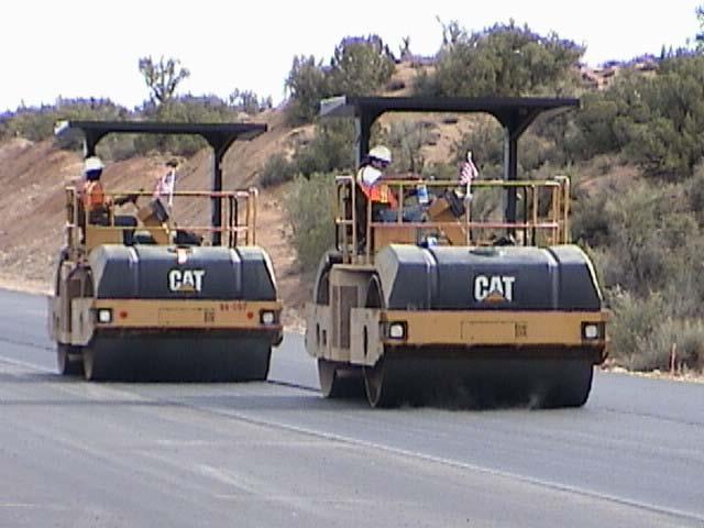
15 Today: Destructive QC/QA Procedures

16 and Laboratory Torture Tests


17 Tomorrow: Remote Sensing Technologies

18 Prospective Sensor Technologies
19 Why Remote Sensing Makes Sense Users Science Safety Pay-Factor Savings Leverage Annual Highway Infrastructure Annual FHWA R&T Annual Savings Due to Superpave

20 It Makes Intuitive Sense A B D C

21 Hyperspectral Image, UCSB Asphaltenes -- Snowflakes of Oil Atomic Force Microscope Image, WRI?
22 Highway Users Perspective * * FHWA User Survey

23 Safety Perspective
24 Financial Perspective Follow the money
25 Leverage Perspective Benefit Savings Cost Cost Spending $117B/yr $0.4B/yr $2.4B/yr Annual Highway Infrastructure Annual FHWA R&T Annual Savings Due to Superpave Return on Investment: SuperPave vs. FHWA R&T
26 R&D Needs Identified by F-SHRP Study * Performance-related specifications for new technologies Efficient construction equipment and methods Non-destructive, real-time sensing to determine readiness for traffic Use of modular or prefabricated construction to speed renewal and minimize disruption Use of advanced computing technologies, such as webbased management, that could speed up renewal projects by providing for better coordination across disciplines and project stages * Performed by the Transportation Research Board of the National Academies
27 Profitability is Linked to Quality Performance

28 Why Remote Sensing Makes Sense Users Science Safety Pay-Factor Leverage Savings Annual Highway Infrastructure Annual FHWA R&T Annual Savings Due to Superpave
29 Western Research Institute Non-Profit Research & Development Organization Formerly Federal Laboratory ( ) Now University of Wyoming Research Corporation A Primary Asphalt Research Arm for FHWA One of the Original SuperPave Contractors Just Held 40 th Annual Asphalt Research Conference A Primary Asphalt Research Arm for FHWA Extensive Relationships with Most State DOTs Field Validations Strips with AZ, KS, NV, WY Experienced Consortium Leader Highway Research Consortium (WRI, TTI, UNR, UW-M, AAT)
30 A Premier Supplier of Pavement Materials Over 40 Years of Asphalt Experience Emphasis on Quality and Performance State of the Art Research and Laboratory Facilities A Leader in Delivering Paving Solutions Owned by Koch Industries 2 nd Largest Privately Held US Company (AA+ Credit) Koch Performance Roads, Inc. Major Projects with Federal Funding NM Route 44 / US-550 VA Route 288, Richmond MoDOT US-63
31 Planning, Engineering, and Construction Management Firm, Founded in 1884 One of the Largest Employee-Owned Companies in US Global Provider of Infrastructure Services Emphasis on Service to Client and Community PB views Sensor Technologies as Key to Sustainability and Cost Effectiveness A Leader in Creating the Design-Build and Warranty Construction Business Models
32 International Full-Service CAD Support, Customization, and Training Company Specialists in Engineering Information Systems for Transportation Projects Contracts with 20 US State DOTs Partnerships with Bentley Systems (MicroStation ) and AutoCAD Track Record of Commercializing New Ideas by Using Familiar Wrappers Raster Utilization in Roadway Projects and WYSIWYG Editing Video Log Libraries on the Web Design Visualization Electronic Bid Sets on the Web
33 O U University of Oklahoma Institute For Exploration & Development Geosciences Expertise in Geophysical, Petrophysical, and Visualization Technologies Used in Energy Exploration Constructed Pavements Are Man-Made Rocks Desires Technology Transfer to Transportation Applications Partnering with Walden 3D, Inc. and Dynamic Resources Corp. Track Record of Modernizing an Industry CAD for Oil and Gas Exploration (Landmark Graphics Corp.) 3D Virtual Reality for Prospecting and Engineering Design MWD Petrophysical Tools Leveraged NASA Expertise to Create Real-Time Down-Hole Remote Sensing Parallel Processing Algorithms for Data Processing
34 Commercial Provider of High-Quality Earth Imagery and Geospatial Information Products, Leveraging DoD Technology In-House Facilities at NASA Stennis Space Center Relationships with Sensor Manufacturers Cross-Agreements with Airborne Imagery Providers QuickBird Is the Highest-Resolution Civilian Satellite 61 cm Panchromatic and 2.8 m Multi-spectral Highest Collection Capacity and Highest Accuracy Other Products Include: Pan-Sharpened Imagery, Mosaics w/ Geometric & Ortho Corrections Color Infrared High Spatial Resolution Satellite Imagery Stereo Imagery and Digital Elevation Models (DEMs) Imagery-Derived Information Extraction and Data Fusion News Flash: NIMA Award to Develop Next Generation Super-High Resolution Commercial Imagery System
35 Possible Research Tasks Catalog RS Solutions for Pavements Investigate High-Impact Applications Surveying Construction Obstacles Compaction Quality Control / Assurance Surface Levelness Quality Control / Assurance Composition Quality Control / Assurance Detecting Premature Surface Aging Predicting Moisture Damage Detecting Early Signs of Base Layer Failure Demonstrate RS Solutions in the Field In Partnership with State DOTs In Partnership with Commercial Interests


36 Surveying Construction Obstacles EPRI Having to tunnel through Granite when you thought you were going to be tunneling through sand has a significant impact on project delivery.

37 Compaction QC / QA TX A&M


38 Surface Levelness QC / QA Ohio State


39 Composition QC / QA DARPA

40 Detecting Premature Surface Aging UCSB


41 NASA Predicting Moisture Damage


42 Detecting Early Signs of Base Layer Failure JPL
43 Deployment Projects Construction QC/QA Deployment (1/3) Borrow Pit Optimization w/ CDOT Buried Infrastructure w/ WyDOT Maintenance Deployment (1/3) Condition Assessment w/ VDOT Washington Bridge Project w/ Maryland SHA & VDOT Research (1/3) Inventory of Available Technologies w/ TRB Sensor tests w/ NASA Lab and Field Sites Warranty Construction Project (Future)
44 Where are we 10+ Years Later?


45 Transportation Business is Where Oil and Gas Was Years Ago W H Y?
46 This is the stage of the innovation process -- between the generation of knowledge and the application in the marketplace -- that poses the greatest challenges to the United States. Science and Technology: A Report to Congress President s Office of Science and Technology Policy Bush Administration, 1991

47 Times Have Changed, Let s Try Again

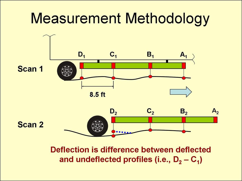
48

49 Core Sample Pattern

50

51

52 The World Through A Laser s Lens
53 Commercial Lidar Resolution ¼ Wavelength Rayleigh Criterion Laser Used Resolution 1064 nm LIDAR 266 nm 532 nm LIDAR 133 nm CUSTOM WAVELENGTHS POSSIBLE!

54
55
56 LAYOUT FOR NEVADA I-15 SITE All Monitoring Sections 500 Feet in Length Sinclair Sinclair Nevada Nevada Venezuelan Venezuelan Canadian Canadian S1. S2. N1. N2. V1. V2. C1. C2. Direction of Traffic (southbound). Core Locations
57 Is This Really What We Want?


58 It s up to smart minds and perceptive businesses to create a new industry.
59 Pie in the Sky? You Decide.
Project Overview Mapping Technology Assessment for Connected Vehicle Highway Network Applications
 Project Overview Mapping Technology Assessment for Connected Vehicle Highway Network Applications AASHTO GIS-T Symposium April 2012 Table Of Contents Connected Vehicle Program Goals Mapping Technology
SURVEYING THE UNDERGROUND
 SURVEYING THE UNDERGROUND An Introduction to ASCE 38-02 and the Practice of Subsurface Utility Engineering ACECMD March 28, 2018 Presented by: Art Worthman A. Morton Thomas & Associates, Inc. John Berrettini
Our Quality Promise WHITE PAPER
 Our Quality Promise www.digitalglobe.com Corporate (U.S.) +1.303.684.4561 or +1.800.496.1225 London +44.20.8899.6801 Singapore +65.6389.4851 To ensure your success, we put quality at our core At DigitalGlobe,
SAUDI ARABIA FUGRO-SUHAIMI LTD. UNDERSTANDING your operational objectives. TACKLING your complex challenges. DELIVERING your global success stories
 SAUDI ARABIA FUGRO-SUHAIMI LTD. UNDERSTANDING your operational objectives TACKLING your complex challenges DELIVERING your global success stories FUGRO-SUHAIMI LTD Fugro-Suhaimi Ltd (FSL) a 50/50 partnership
SEAM Pressure Prediction and Hazard Avoidance
 Announcing SEAM Pressure Prediction and Hazard Avoidance 2014 2017 Pore Pressure Gradient (ppg) Image courtesy of The Leading Edge Image courtesy of Landmark Software and Services May 2014 One of the major
National Asphalt Roadmap
 National Asphalt Roadmap Dale Decker Peterson Conference Western Research Institute Laramie, WY ASPHALT INSTITUTE 1 Construction Definitions Contractor: a gambler who never gets to shuffle, cut or deal
Brief to the. Senate Standing Committee on Social Affairs, Science and Technology. Dr. Eliot A. Phillipson President and CEO
 Brief to the Senate Standing Committee on Social Affairs, Science and Technology Dr. Eliot A. Phillipson President and CEO June 14, 2010 Table of Contents Role of the Canada Foundation for Innovation (CFI)...1
CONTROL AND RESEARCH LABORATORIES IN THE ASPHALT INDUSTRY
 CONTROL AND RESEARCH LABORATORIES IN THE ASPHALT INDUSTRY (Is there any space for the emulsions?) WITH A SHORT INTRODUCTION ON THE ITALIAN MARKET Carlo Giavarini, SITEB Italy SHORT INTRODUCTION ON THE
2008 ConnDOT Photolog Program Overview
 2008 ConnDOT Photolog Program Overview Brad Overturf, Transportation Photolog Supervisor Northeast Pavement Preservation Partnership 2008 Good morning. Thank you to the Northeast Pavement Preservation
Active and Passive Microwave Remote Sensing
 Active and Passive Microwave Remote Sensing Passive remote sensing system record EMR that was reflected (e.g., blue, green, red, and near IR) or emitted (e.g., thermal IR) from the surface of the Earth.
FHWA s Demonstration Project for Enhanced Durability Through Increased Density
 FHWA s Demonstration Project for Enhanced Durability Through Increased Density Courtesy Asphalt Institute TIM ASCHENBRENER, P.E. SENIOR ASPHALT PAVEMENT ENGINEER PAVEMENT MATERIALS TEAM OFFICE OF PRECONSTRUCTION,
Automated Machine Guidance
 Design Manual Chapter 5 - Roadway Design 5H - Automated Machine Guidance 5H-1 Automated Machine Guidance A. Concept Automated machine guidance (AMG) for grading is a process in which grading equipment,
Services Overview. Northeast Blueprint
 Services Overview 2D CAD Conversions Paper to CAD 2D CAD Conversions Construction Engineering / CAD Services Construction Markups Consultant Drawings Coordinated Drawings As -Builts Steel Structural Detailing
DigitalGlobe High Resolution Satellite Imagery
 DigitalGlobe High Resolution Satellite Imagery KIAN KANG, SALES MANAGER, SOUTH EAST ASIA & TAIWAN See a better world. DigitalGlobe Overview Over 1,300 employees spanning the globe H E A D Q UA R T E R
EMBRACING A QUALITY CULTURE
 EMBRACING A QUALITY CULTURE Flexible Pavements of Ohio, 49 th Annual Meeting More Tons Through Value Harold Mullen Texas Asphalt Pavement Association DALLAS COWBOYS STADIUM How Bout Them Cowboys Parking
FMI Prefabrication Forum. The Changing Face of Engineering & Construction
 FMI Prefabrication Forum The Changing Face of Engineering & Construction Ethan Cowles, Director 2 The past doesn t always match the future. That s the nature of disruption. Patterns of change build gradually
The University of Alberta: Industrial Collaborative Opportunities
 The University of Alberta: Industrial Collaborative Opportunities Ian R. Mann CRC in Space Physics Co-Director of ISSET University of Alberta ian.mann@ualberta.ca UofA Institute for Space Science Exploration
The Sherwin-Williams Company
 The Sherwin-Williams Company "What is Worth Doing is Worth Doing Well." Founded in 1866 in Cleveland, Ohio #1 coatings company in the Americas #3 coatings company worldwide Over 40,000 employees worldwide
2012 ACCE Industry Advisory Board Best Practices Positioning Your Firm After the Great Recession
 2012 ACCE Industry Advisory Board Best Practices Positioning Your Firm After the Great Recession 2012 FMI Corporation 0 The Great Recession 2012 FMI Corporation 1 FMI Corporation 2010 1 Market Truths You
Taking a broader view
 Taking a broader view A brief introduction to DNV GL 1 SAFER, SMARTER, GREENER We are a global classification, certification, technical assurance and advisory company 2 In a challenging world we make businesses
Integration of Traditional and Non- Traditional Remote Sensing for Bridge Condition Assessment
 Integration of Traditional and Non- Traditional Remote Sensing for Bridge Condition Assessment Tess Ahlborn, Ph.D., P.E., FPCI Devin Harris, Ph.D., Colin Brooks and Larry Sutter, Ph.D. Michigan Technological
New Approaches to Manufacturing Innovation in DOE
 New Approaches to Manufacturing Innovation in DOE March 6, 2013 TMS 2013 Annual Meeting Dr. Robert Ivester Director (Acting) Advanced Manufacturing Office 1 Energy Efficiency and Renewable Energy eere.energy.gov
Active and Passive Microwave Remote Sensing
 Active and Passive Microwave Remote Sensing Passive remote sensing system record EMR that was reflected (e.g., blue, green, red, and near IR) or emitted (e.g., thermal IR) from the surface of the Earth.
Automated Machine Guidance An Emerging Technology Whose Time has Come?
 Lou Barrett Page 1 Automated Machine Guidance An Emerging Technology Whose Time has Come? Author: Lou Barrett Chairwoman AASHTO TIG AMG Minnesota Department of Transportation MS 688 395 John Ireland Blvd.
Climate Change Innovation and Technology Framework 2017
 Climate Change Innovation and Technology Framework 2017 Advancing Alberta s environmental performance and diversification through investments in innovation and technology Table of Contents 2 Message from
INTELLIGENT COMPACTION
 INTELLIGENT COMPACTION Directions to the Future Jimmy Si, Ph.D., P.E. San Antonio, TX, Mar. 20, 2014 Table of Contents 1 What Is Intelligent Compaction 3-5 2 Why Use Intelligent Compaction 6-8 3 National
A CONCEPT FOR NATURAL GAS TRANSMISSION PIPELINE MONITORING BASED ON NEW HIGH-RESOLUTION REMOTE SENSING TECHNOLOGIES
 A CONCEPT FOR NATURAL GAS TRANSMISSION PIPELINE MONITORING BASED ON NEW HIGH-RESOLUTION REMOTE SENSING TECHNOLOGIES Werner Zirnig - Ruhrgas Aktiengesellschaft Dieter Hausamann - DLR German Aerospace Center
Leica - 3 rd Generation Airborne Digital Sensors Features / Benefits for Remote Sensing & Environmental Applications
 Leica - 3 rd Generation Airborne Digital Sensors Features / Benefits for Remote Sensing & Environmental Applications Arthur Rohrbach, Sensor Sales Dir Europe, Middle-East and Africa (EMEA) Luzern, Switzerland,
How Industry Assesses Areas for R&D Investment
 How Industry Assesses Areas for R&D Investment Susan B. Butts, PhD Sr. Director, External Science & Technology Programs The Dow Chemical Company AAAS Forum on Science & Technology Policy Topics Relative
How to Access Imagery and Carry Out Remote Sensing Analysis Using Landsat Data in a Browser
 How to Access Imagery and Carry Out Remote Sensing Analysis Using Landsat Data in a Browser Including Introduction to Remote Sensing Concepts Based on: igett Remote Sensing Concept Modules and GeoTech
Turning the wheels of your success
 INDUSTRIAL SERVICES Turning the wheels of your success A comprehensive package of integrated services combining traditional certification and inspection with innovative business solutions based on the
European Space Imaging. Your Partner for Very High-Resolution Satellite Imagery GEOGRAPHIC
 European Space Imaging Your Partner for Very High-Resolution Satellite Imagery XVII International User Conference of GeoInformation Systems & Remote Sensing European Space Imaging Your Partner for Very
Managing Risk in the Digital Age. Mechanical Contractors Association of Houston September 26, 2018
 Managing Risk in the Digital Age Mechanical Contractors Association of Houston September 26, 2018 If you don t like change, you re going to like irrelevance even less. General Eric Shinseki, U.S. Army
Satellite Imagery Characteristics, Uses and Delivery to GIS Systems. Wayne Middleton April 2014
 Satellite Imagery Characteristics, Uses and Delivery to GIS Systems Wayne Middleton April 2014 About Geoimage Founded in Brisbane 1988 Leading Independent company Specialists in satellite imagery and geospatial
Introduction of CSRSR Image product processing systems in CSRSR Disaster monitoring and data processing
 3 rd Joint Project Team Meeting for Sentinel Asia STEP3 Data Analysis Node Report Li-Yu Chang Associate Research Engineer Center for Space and Remote Sensing Research National Central University, Taiwan
Ground Truth for Calibrating Optical Imagery to Reflectance
 Visual Information Solutions Ground Truth for Calibrating Optical Imagery to Reflectance The by: Thomas Harris Whitepaper Introduction: Atmospheric Effects on Optical Imagery Remote sensing of the Earth
WITH Woodside. The Woodside Innovation & Technology Hub. Building a community of world-class innovators to unlock tomorrow s growth opportunities.
 WITH Woodside The Woodside Innovation & Technology Hub Building a community of world-class innovators to unlock tomorrow s growth opportunities. WITH Woodside is a concept aiming to be launched in 2015
Consortium Capabilities
 Consortium Capabilities The driver in advanced materials development is to create products with competitive advantages. Products must continuously become faster, lighter and cheaper and must provide additional
Metrology at NRC Canada: An NMI in an RTO Context
 Metrology at NRC Canada: An NMI in an RTO Context Alan Steele NRC Measurement Science and Standards National Laboratory Association South Africa Test and Measurement Conference and Workshop September 30,
Clear Roads Overview. National Winter Maintenance Peer Exchange September 12-13, 2017 Pittsburgh, PA
 Clear Roads Overview National Winter Maintenance Peer Exchange September 12-13, 2017 Pittsburgh, PA Overview Clear Roads Winter Highway Operations Pooled Fund, TPF-5(353), is a national research consortium
Intellectual Property, Vaccine Production and Technology Transfer
 Intellectual Property, Vaccine Production and Technology Transfer Vaccine Industry Perspective P. Fournier, On behalf of IFPMA Bio Group 19-20 April 2004, WHO HQ, Geneva 1 OUTLINE General considerations
Acknowledging Jackson s Challenges for Growth The Significance of People & Place
 Acknowledging Jackson s Challenges for Growth Updated 07/29/15 The Enterprise Group of Jackson, Inc. (EG) is the economic development agency supporting all of Jackson County. The Enterprise Group of Jackson,
Work Type Definition and Submittal Requirements 14.6 Signing Plan Design & Special Provisions. Work Type Definition
 Work Type Definition Pages 1-3 detail the work type definition. In order to become pre-qualified for this work type, please see the Work Type Submittal Requirements on pages 4-6. I. Description Signing
Spatial-Spectral Target Detection. Table 1: Description of symmetric geometric targets
 Experiment Spatial-Spectral Target Detection Investigator: Jason Kaufman Support Crew: TBD Short Title: Objectives: Spatial-Spectral Target Detection The aim of this experiment is to detect and distinguish
CANADA S OCEAN SUPERCLUSTER DRAFT NOVEMBER 1
 CANADA S OCEAN SUPERCLUSTER AGENDA 01 What is the Ocean Supercluster? 02 What is the opportunity for business? 03 What is the opportunity for Canada? 04 How will the Ocean Supercluster work? 05 What are
An Energy Utility Perspective and Approach to Airborne Wind
 Setting the Pace in Renewable Energy An Energy Utility Perspective and Approach to Airborne Wind Kester Gunn Henrik Wall Freiburg 06.10.2017 Renewable energy is one of the three key pillars in E.ONs strategy
Rapid Technologies to Enhance Quality Control on Asphalt Pavements Infrared (IR) Scanner Showcase. Hosted by: Missouri DOT June 1, 2016
 Scanner Showcase. Hosted by: Missouri DOT June 1, 2016") Rapid Technologies to Enhance Quality Control on Asphalt Pavements Infrared (IR) Scanner Showcase Hosted by: Missouri DOT June 1, 2016 Welcome & Introductions 1. Missouri DOT 2. AASHTO 3. FHWA 2 Our Focus
Rapid Technologies to Enhance Quality Control on Asphalt Pavements Infrared (IR) Scanner Showcase Hosted by: Missouri DOT June 1, 2016 Welcome & Introductions 1. Missouri DOT 2. AASHTO 3. FHWA 2 Our Focus
Arshad Mansoor, Sr. Vice President, Research & Development INNOVATION SCOUTS: EXPANDING EPRI S TECHNOLOGY INNOVATION NETWORK
 RAC Briefing 2011-1 TO: FROM: SUBJECT: Research Advisory Committee Arshad Mansoor, Sr. Vice President, Research & Development INNOVATION SCOUTS: EXPANDING EPRI S TECHNOLOGY INNOVATION NETWORK Research
The SEMATECH Model: Potential Applications to PV
 Continually cited as the model for a successful industry/government consortium Accelerating the next technology revolution The SEMATECH Model: Potential Applications to PV Dr. Michael R. Polcari President
Smart Cities. Wednesday, May 16, :30 a.m. - 12:00 p.m. (EDT) What is a smart city? Are we ready for it? What are the challenges?
 What is a smart city? Are we ready for it? What are the challenges?") Smart Cities Wednesday, May 16, 2018 11:30 a.m. - 12:00 p.m. (EDT) What is a smart city? Are we ready for it? What are the challenges? Elements of a Smart(er) City The application of a wide range of electronic
Smart Cities Wednesday, May 16, 2018 11:30 a.m. - 12:00 p.m. (EDT) What is a smart city? Are we ready for it? What are the challenges? Elements of a Smart(er) City The application of a wide range of electronic
Maverick Inspection Ltd. has been pioneering specialized non-destructive testing in Western Canada
 TECHNOLOGY, EXPERTISE & SOLUTIONS Maverick Inspection Ltd. has been pioneering specialized non-destructive testing in Western Canada since 1994. As a Canadian-owned and operated company, we have earned
Jointed Precast Concrete Pavement
 NATIONAL PRECAST CONCRETE ASSOCIATION Manual for Jointed Precast Concrete Pavement 3rd Edition Authors Peter Smith, P.E. Mark B. Snyder, Ph.D., P.E. Graphic Designer Deborah Templeton NPCA Precast Concrete
Helping Build Your Capacity in Nautical Charting & Hydrography
 Helping Build Your Capacity in Nautical Charting & Hydrography Helping Chart your World Rajesh Alla Riyadh, Kingdom of Saudi Arabia 04-06 March 2013 Company Background Marine Services Capacity Building
CONTACT DETAILS. NNC s Leak Sealing Services. Greg Willetts, Head Of Leak Sealing Services. Phone: +44 (0)
") CONTACT DETAILS NNC s Leak Sealing Services Greg Willetts, Head Of Leak Sealing Services Email: greg.willetts@nnc.co.uk Phone: +44 (0)1925 89 5654 NNC Technology Business Simon James, Sales and Marketing
CONTACT DETAILS NNC s Leak Sealing Services Greg Willetts, Head Of Leak Sealing Services Email: greg.willetts@nnc.co.uk Phone: +44 (0)1925 89 5654 NNC Technology Business Simon James, Sales and Marketing
MSB Imagery Program FAQ v1
 MSB Imagery Program FAQ v1 (F)requently (A)sked (Q)uestions 9/22/2016 This document is intended to answer commonly asked questions related to the MSB Recurring Aerial Imagery Program. Table of Contents
Industrial and Regional Benefits (IRB s)
") Industry Canada Opportunities for Collaboration Jim Castellano - Sector Development Officer, Aerospace, Defence and Marine Branch Government of Canada Ottawa, Ontario Jim.Castellano@ic.gc.ca - 613-954-3747
Industry Canada Opportunities for Collaboration Jim Castellano - Sector Development Officer, Aerospace, Defence and Marine Branch Government of Canada Ottawa, Ontario Jim.Castellano@ic.gc.ca - 613-954-3747
Moving to Model-Based Design
 Infrastructure Solutions White Paper Moving to Model-Based Design Choosing Between 2D and 3D Do you really have to choose between 2D and 3D? The answer is no, but it is important to know why. Over the
Advanced Methods to Identify Asphalt Pavement Delamination (R06D) Ground Penetrating Radar (GPR) Caltrans
 Ground Penetrating Radar (GPR) Caltrans") Advanced Methods to Identify Asphalt Pavement Delamination (R06D) Ground Penetrating Radar (GPR) Caltrans William Owen Peer Exchange August 1-3, 2018 Introduction How We Got Here Strategic Highway Research
Advanced Methods to Identify Asphalt Pavement Delamination (R06D) Ground Penetrating Radar (GPR) Caltrans William Owen Peer Exchange August 1-3, 2018 Introduction How We Got Here Strategic Highway Research
Partnering: Labs and Small Businesses
 Partnering: Labs and Small Businesses NATIONAL SBIR/STTR FALL CONFERENCE Nov 13, 2014 Alex Athey, Ph.D. Applied Research Laboratories The University of Texas at Austin alex.athey@arlut.utexas.edu 512-777-1616
SOLAR. Representing clients across the renewable energy industry. Troutman Sanders LLP. troutman.com
 SOLAR Representing clients across the renewable energy industry What clients value Troutman Sanders served as counsel to over 5600 MWs of solar projects in 2016-2017. U.S. News Best Lawyers Our innovative
CONSTRUCTION MACHINES IN THE DIGITAL AGE CONSTRUCTION EQUIPMENT MAKERS NEED TO FIND THEIR PLACE IN SMART BUILDING SITES. Romed Kelp and David Kaufmann
 CONSTRUCTION MACHINES IN THE DIGITAL AGE CONSTRUCTION EQUIPMENT MAKERS NEED TO FIND THEIR PLACE IN SMART BUILDING SITES Romed Kelp and David Kaufmann At first glance, giant earth-moving excavators and
OFFSHORE ANALYSIS & RESEARCH SOLUTIONS HOUSTON PETROLEUM SURVEYORS GROUP PERSONNEL DATA PROCESSING PARTNERSHIPS
 OFFSHORE ANALYSIS & RESEARCH SOLUTIONS HOUSTON PETROLEUM SURVEYORS GROUP KEEPING YOUR PROJECTS IN MOTION OARS-HPSG combines the experience of two highly complementary organizations providing expanded capabilities,
2010 Bentley Systems, Incorporated. Point Clouds in MicroStation V8i
 Point Clouds in MicroStation V8i LiDAR Challenges Working with many forms of LiDAR (light detection and ranging) Laser Scanning Airborne LiDAR Mobile Mapping Systems All forms produce large data sets that
FUGRO GROUP BUILDING AND INFRASTRUCTURE. TACKLING your complex challenges. UNDERSTANDING your operational objectives
 BUILDING AND INFRASTRUCTURE FUGRO GROUP UNDERSTANDING your operational objectives TACKLING your complex challenges DELIVERING your global success stories BUILDING AND INFRASTRUCTURE With a wide variety
Update on Landsat Program and Landsat Data Continuity Mission
 Update on Landsat Program and Landsat Data Continuity Mission Dr. Jeffrey Masek LDCM Deputy Project Scientist NASA GSFC, Code 923 November 21, 2002 Draft LDCM Implementation Phase RFP Overview Page 1 Celebrate!
It all starts here. Format fermé : 9" x 12" Format ouvert : 18 x 12 Marges : 0,125" Couleurs : CMYK
 It all starts here 4521, rue clark, montréal (québec) H2T 2T3 t. 514.286.9696 f. 514.284.9152 espressocommunication.com Date : 3 septembre 2010 Client : Ultragen Projet : ULT1001_Brochure EN Numéro d épreuve:
INNOVATIVE SPECTRAL IMAGING
 INNOVATIVE SPECTRAL IMAGING food inspection precision agriculture remote sensing defense & reconnaissance advanced machine vision product overview INNOVATIVE SPECTRAL IMAGING Innovative diffractive optics
Sparking a New Economy. Canada s Advanced Manufacturing Supercluster
 Sparking a New Economy Canada s Advanced Manufacturing Supercluster Canada s Advanced Manufacturing Supercluster Canada's Advanced Manufacturing Supercluster Strategy will leverage Canada s innovation
GeoBase Raw Imagery Data Product Specifications. Edition
 GeoBase Raw Imagery 2005-2010 Data Product Specifications Edition 1.0 2009-10-01 Government of Canada Natural Resources Canada Centre for Topographic Information 2144 King Street West, suite 010 Sherbrooke,
Saturation And Value Modulation (SVM): A New Method For Integrating Color And Grayscale Imagery
: A New Method For Integrating Color And Grayscale Imagery") 87 Saturation And Value Modulation (SVM): A New Method For Integrating Color And Grayscale Imagery By David W. Viljoen 1 and Jeff R. Harris 2 Geological Survey of Canada 615 Booth St. Ottawa, ON, K1A 0E9
87 Saturation And Value Modulation (SVM): A New Method For Integrating Color And Grayscale Imagery By David W. Viljoen 1 and Jeff R. Harris 2 Geological Survey of Canada 615 Booth St. Ottawa, ON, K1A 0E9
Innovative Solutions Across the E&P Lifecycle. ACCESS EXPLORATION APPRAISAL DEVELOPMENT PRODUCTION
 Innovative Solutions Across the E&P Lifecycle. ACCESS EXPLORATION APPRAISAL DEVELOPMENT PRODUCTION Innovative Solutions, from Access to Production Uncertainty Knowledge ACCESS EXPLORATION APPRAISAL DEVELOPMENT
Integrating Survey, CAD and GIS into a Single Solution
 Pete KELSEY, USA Keywords: Engineering survey;geoinformation/gi;gps;photogrammetry;remote sensing; GIS; CAD; Civil 3D SUMMARY Any enterprise, public or private, that acquires, edits, or provides surveying,
Outline for today. Geography 411/611 Remote sensing: Principles and Applications. Remote sensing: RS for biogeochemical cycles
 Geography 411/611 Remote sensing: Principles and Applications Thomas Albright, Associate Professor Laboratory for Conservation Biogeography, Department of Geography & Program in Ecology, Evolution, & Conservation
!!!! Remote Sensing of Roads and Highways in Colorado
 !!!! Remote Sensing of Roads and Highways in Colorado Large-Area Road-Surface Quality and Land-Cover Classification Using Very-High Spatial Resolution Aerial and Satellite Data Contract No. RITARS-12-H-CUB
MANUFACTURING INSTITUTE
 GEO RG IA TECH MANUFACTURING INSTITUTE Leading manufacturers to successful deployment The Georgia Tech Manufacturing I nstitute will be the world s premier institution anticipating needs and providing
SPOT6. Impact of Spot 6 and 7 in the Constitution and Update of Spatial Data Infrastructures over Africa
 Astrium Services 2012 SPOT6 Impact of Spot 6 and 7 in the Constitution and Update of Spatial Data Infrastructures over Africa K. Guérin, M. Bernard, T. Rousselin, B. Navaro, J. Korona 26 th International
An Introduction to Geomatics. Prepared by: Dr. Maher A. El-Hallaq خاص بطلبة مساق مقدمة في علم. Associate Professor of Surveying IUG
 An Introduction to Geomatics خاص بطلبة مساق مقدمة في علم الجيوماتكس Prepared by: Dr. Maher A. El-Hallaq Associate Professor of Surveying IUG 1 Airborne Imagery Dr. Maher A. El-Hallaq Associate Professor
GEO 428: DEMs from GPS, Imagery, & Lidar Tuesday, September 11
 GEO 428: DEMs from GPS, Imagery, & Lidar Tuesday, September 11 Global Positioning Systems GPS is a technology that provides Location coordinates Elevation For any location with a decent view of the sky
Earth Observations from Space U.S. Geological Survey
 Earth Observations from Space U.S. Geological Survey Geography Land Remote Sensing Program Dr. Bryant Cramer April 1, 2009 U.S. Department of the Interior U.S. Geological Survey USGS Landsat Historical
Paver, Roller & Cold Planer Innovations
 Paver, Roller & Cold Planer Innovations Technology How is it emerging in construction? First, technology will continue to become more human-centric where it will increase transparency between people, businesses,
Warren Cartwright, Product Manager MDA Geospatial Services, Canada
 Advanced InSAR Techniques for Urban Infrastructure Monitoring Warren Cartwright, Product Manager MDA Geospatial Services, Canada www.mdacorporation.com RESTRICTION ON USE, PUBLICATION OR DISCLOSURE OF
What is BIM and why should construction lawyers care about it? Dr. Carrie Sturts Dossick, P.E. Bita Astaneh Asl
 What is BIM and why should construction lawyers care about it? Dr. Carrie Sturts Dossick, P.E. Bita Astaneh Asl Learning Objectives What is BIM? > BIM definition > BIM history > Common current uses (3D
Center for Research-Based Innovation for Integrated Operations at NTNU/SINTEF/IFE. Professor Jon Kleppe, NTNU
 Center for Research-Based Innovation for Integrated Operations at NTNU/SINTEF/IFE Professor Jon Kleppe, NTNU 1 The objective of the new center is to develop new knowledge, methods and tools for the next
QUATERNARY PARK: RETRIEVAL OF LOST SATELLITE IMAGES FROM THE LATE 20TH CENTURY
 QUATERNARY PARK: RETRIEVAL OF LOST SATELLITE IMAGES FROM THE LATE 20TH CENTURY Grady Price Blount Department of Physical and Life Sciences Texas A & M University Corpus Christi, TX Thomas M. Holm U.S.
Augmented Reality in Transportation Construction
 September 2018 Augmented Reality in Transportation Construction FHWA Contract DTFH6117C00027: LEVERAGING AUGMENTED REALITY FOR HIGHWAY CONSTRUCTION Hoda Azari, Nondestructive Evaluation Research Program
Are your company and board ready for digital transformation?
 August 2017 Are your company and board ready for digital transformation? Going digital means change. Having the right skills is a critical part of the process. As overseers of company strategy, the board
Autodesk for the Transportation Industry. Experience It Before It s Real
 Autodesk for the Transportation Industry Experience It Before It s Real Get Your Products Moving Easier and Faster Improve collaboration and productivity with the Autodesk solution for Digital Prototyping.
Earth Cube Technical Solution Paper the Open Science Grid Example Miron Livny 1, Brooklin Gore 1 and Terry Millar 2
 Earth Cube Technical Solution Paper the Open Science Grid Example Miron Livny 1, Brooklin Gore 1 and Terry Millar 2 1 Morgridge Institute for Research, Center for High Throughput Computing, 2 Provost s
AASHTO IDRRIM meeting
 AASHTO IDRRIM meeting Marc TASSONE, IDRRIM Managing Director 2014 May 16 What about IDRRIM : Reference Partnership Institute for the community of public - private actors working for a shared interest :
Preparing for an Uncertain Future:
 : for a Greater Baltimore Region DRAFT Maximize2040 is an initiative of the Baltimore Regional Transportation Board, the metropolitan planning organization for the Baltimore region. 1 SCENARIO THINKING:
Realtime Airborne Imagery for Emergency GIS Applications
 Realtime Airborne Imagery for Emergency GIS Applications Demonstration and Evaluation with Monroe County Office of Emergency Management August - September 2010 Information Products Laboratory for Emergency
Advances in Intelligent Compaction for HMA
 Advances in Intelligent Compaction for HMA NCAUPG HMA Conference Overland Park, Ks. Victor (Lee) Gallivan, PE FHWA - Office of Pavement Technology February 3, 2010 What is Intelligent Compaction Technology
PLENARY AND KEYNOTE SPEAKERS 2018 ACGM
 PLENARY AND KEYNOTE SPEAKERS 2018 ACGM Opening Plenary Speaker, Mr. Pepper Harward, Vice-President, Routematch Software, Monday June 18, 2018 8:15 am As Vice President of Transit Solutions for Routematch
Aerial photography: Principles. Frame capture sensors: Analog film and digital cameras
 Aerial photography: Principles Frame capture sensors: Analog film and digital cameras Overview Introduction Frame vs scanning sensors Cameras (film and digital) Photogrammetry Orthophotos Air photos are
MOBILITY RESEARCH NEEDS FROM THE GOVERNMENT PERSPECTIVE
 MOBILITY RESEARCH NEEDS FROM THE GOVERNMENT PERSPECTIVE First Annual 2018 National Mobility Summit of US DOT University Transportation Centers (UTC) April 12, 2018 Washington, DC Research Areas Cooperative
Partnering with Industry
 U.S. Army Edgewood Chemical Biological Center Partnering with Industry Michael Abaie, Director of Engineering, ECBC 22 July 2015 Approved for Public Release Edgewood Chemical Biological Center Specialized
Chemionix Solutions. Outsourcing. Engineering. Drafting
 Chemionix Solutions. Outsourcing. Engineering. Drafting Chemionix Your Outsourcing Partner Companies have been outsourcing since time began. It is only recently that business processes can be outsourced
Technical Notes LAND MAPPING APPLICATIONS. Leading the way with increased reliability.
 LAND MAPPING APPLICATIONS Technical Notes Leading the way with increased reliability. Industry-leading post-processing software designed to maximize the accuracy potential of your POS LV (Position and
FLIGHT SUMMARY REPORT
 FLIGHT SUMMARY REPORT Flight Number: 97-011 Calendar/Julian Date: 23 October 1996 297 Sensor Package: Area(s) Covered: Wild-Heerbrugg RC-10 Airborne Visible and Infrared Imaging Spectrometer (AVIRIS) Southern
to Geospatial Technologies
 What s in a Pixel? A Primer for Remote Sensing What s in a Pixel Development UNH Cooperative Extension Geospatial Technologies Training Center Shane Bradt UConn Cooperative Extension Geospatial Technology