DP MAINTENANCE INTRODUC INTR TION T TION O SENS T OR O SENS S OR
|
|
|
- Emery Shields
- 5 years ago
- Views:
Transcription
1 DP MAINTENANCE INTRODUCTION TO SENSORS


2 Sensors Wind Sensors PMEs Workstations Gyrocompasses Network Switchbox Network Switchbox Controller Cabinets Dual Ethernet Motion Sensors (VRU) Field Stations Thrusters UPSs


3 Gyrocompasses Measurement of vessel s heading Location - typically on bridge Interface to DP system: Serial (RS 422) SG Brown Litton Anschutz

 Young Gill")
4 Anemometers Measurement of wind speed and direction Location - ideally at the top of the mast not on top of derrick Ultrasonic sensors subject to weather induced errors and icing Interface to DP System: Speed and Direction - Serial (RS 422) Young Gill Observator


5 Vertical Reference Units Measurement of pitch, roll and heave Location - ideally on the vessel s centre of roll and pitch Interface to DP system: Serial (RS 422) Offsets need to be correct otherwise errors induced into DP TSS Datawell
6 Sensors - Rejection Criteria Gyrocompasses Is the input signal OK? How close is the measurement compared to the other compasses? Vertical Reference Units Is the input signal OK? How close is the measurement compared to the other VRUs? Is the vessel pitching and rolling? Anemometers Is the input signal OK? How close are the measurements compared to the other anemometers? Is the wind strong enough?
7 PMEs Wind Sensors PMEs Workstations Gyrocompasses Network Switchbox Network Switchbox Controller Cabinets Dual Ethernet Motion Sensors (VRU) Field Stations Thrusters UPSs


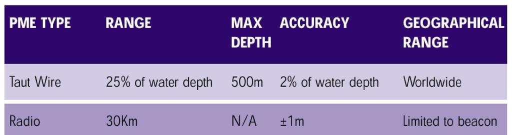
8 Taut Wire Measurement of vessel s position relative to the weight. Suppliers: Converteam Simrad DPS Accuracy < 1m Advantages: High accuracy in <150m water depth Good reliability Quick and easy to set up Disadvantages Short range only Susceptible to strong tides Possibility of weight dragging Only up to 300m water depth
9 Taut Wire Guide Arm with Inclinometers in F/A Axes Vessel offset contant Constant Tension Winch Correction Required For vessel motion Constant VCG Vessel Variable Water Depth Manual Input by Operator or automatic calculation from line length at Mooring 60 deg Cone Angle Maximum Working Depressor Weight Sea Bed
10 Taut Wire


11 Hydro-Acoustics Measurement of vessel s position relative to the transponder Suppliers: Sonardyne Simrad Nautronix Applications: Vessel positioning ROV positioning Survey work Drilling operations Accuracy: 1-5m Update rates: 1s to 8s, dependent upon water depth
12 Hydro-Acoustics Range Measurement d = v t Speed of Sound in Water: 1483 m/s
13 Hydro-Acoustics Short Base-Line (SBL)
14 Hydro-Acoustics Super Short Base-Line (SSBL or USBL) Phase Not Time Lower Position Discrimination More economic installation. Operates Multiple Transponders 10 khz around 3.5 cm wavelength 35 khz around 1 cm wavelength
15 Hydro-Acoustics Long Base Line (LBL) Intelligent Transponders Deepwater Accuracy No VRU. Difficult to deploy minimum three transponders
16 Hydro-Acoustics SBL USBL LBL Simple Operation - Expensive Ship Installation Accurate to beyond 1000 M Requires real time MRU Complex Operation - Less Expensive Ship Installation Accurate to 500 M Sensitive to Noise Requires real time MRU Complex Operation - Less Expensive Ship Installation Difficult deployment 3 transponders + min separation Accurate to beyond 1500 M Time Delay Less Sensitive to Noise No need for MRU in deepwater
17 Hydro-Acoustics SBL - Short Base Line USBL - Ultra Short Base Line LBL - Long Base Line LSBL - Long Short Base Line LUSBL - Long Ultra Short Base Line
18 Hydro-Acoustics Mud Sources of Interference Propeller Noise and Wash Reflections Fish Marine Growth Water Ingress Hydrophone offsets need to be correct to avoid errors being introduced Sudden with visual confirmation Intermittent obs ship s head Shallow water Xpdr power Theft Gradual loss of sensitivity over time, poor response after layup
19 Global Positioning System (GPS) 31 satellites + 2 in-orbit spares 6 orbital planes 55 degree orbital inclination Altitude 20200km 12-hour orbit GPS Accuracy 5m to 10m

20 Differential GPS (DGPS) DGPS Accuracy <1m to 5m Suppliers Thales Sercel Seatex Trimble Dedicated local corrections Coastal beacons Global corrections via satellite

21 DGPS - Typical Hardware Configurations

22 DGPS - Inmarsat Coverage

23 DGPS - Spotbeam Coverage
24 Correction Signals Radio Band Inmarsat Spotbeam UHF HF LF Range World-wide World-wide 40 km 600 km 700 km
25

26


27 Artemis Measurement of vessel s position relative to the fixed station Suppliers - Reson Range m Range/bearing accuracy 0.1-1m / 0.02 degrees Advantages: short to medium range high accuracy at short range Disadvantages: line-of-sight fixed-end requires set-up reflections interference from radar
28


29 Fanbeam Measurement of vessel s position relative to the reflector Suppliers: MDL Range (DP use): up to 200m Accuracy: 1m Advantages: easily installed low cost in comparison passive target Disadvantages: dirty lens line of sight false targets low sun


30 Laser Reflectors Tube Targets and Prism Cluster Arrays
.")

31 CyScan Similar to Fanbeam, but more advanced. Measurement of vessel s position relative to the reflector(s). Suppliers: Converteam/Guidance Navigation Range (DP use): up to 400m Accuracy: 1m Advantages: easily installed low cost in comparison passive target Disadvantages: dirty lens line of sight
32 CyScan Use Continuously rotating fanned laser head measures targets bearing, range, width, etc.

33 CyScan Use Auto-tracking of target ship s speed and position Auto-tracking of target ship s heading Target ship
34 PME Comparison
08/10/2013. Marine Positioning Systems Surface and Underwater Positioning. egm502 seafloor mapping
 egm502 seafloor mapping lecture 8 navigation and positioning Marine Positioning Systems Surface and Underwater Positioning All observations at sea need to be related to a geographical position. To precisely
DP Operator Course Training Manual HPR
 - Hydroacoustic Position Reference System consists of transducer(s) onboard a vessel communicating with transponder(s) placed on the seabed. The transducers are lowered beneath the hull, and when a transponder
Tightly Integrated Second Generation Acoustic-Inertial Position Reference Systems
 Return to Session Menu DYNAMIC POSITIONING CONFERENCE October 15-16, 2013 SENSORS SESSION II Tightly Integrated Second Generation Acoustic-Inertial Position Reference Systems Mark Carter Sonardyne International
ACOUSTIC POSITIONING SYSTEMS A PRACTICAL OVERVIEW OF CURRENT SYSTEMS
 DYNAMIC POSITIONING CONFERENCE October 13 14, 1998 SENSORS ACOUSTIC POSITIONING SYSTEMS A PRACTICAL OVERVIEW OF CURRENT SYSTEMS Keith Vickery Sonardyne, Inc. ACOUSTIC POSITIONING SYSTEMS A PRACTICAL OVERVIEW
Ranger USBL Acoustic Positioning System for DP Reference and Survey
 Acoustic Positioning System for DP Reference and Survey cc 545000m N 544990m 544980m 544970m 6027910m 6027900m W 6027890m 6027880m S Contents Introduction 01 Ranger USBL System Overview 02 Ranger USBL
Applications of iusbl Technology overview
 Applications of iusbl Technology overview Tom Bennetts Project Manager Summary 1. What is iusbl and its target applications 2. Advantages of iusbl and sample data 3. Technical hurdles and Calibration methods
WORLD CLASS through people, technology and dedication WORLD CLASS through people, technology and dedication
 WORLD CLASS through people, technology and dedication WORLD CLASS through people, technology and dedication 1 2 Acoustic Positioning Systems Hydrofest Aberdeen University Wednesday 31 st March Ian Florence
MARKSMAN DP-INS DYNAMIC POSITIONING INERTIAL REFERENCE SYSTEM
 cc MARKSMAN DP-INS DYNAMIC POSITIONING INERTIAL REFERENCE SYSTEM Sonardyne s Marksman DP-INS is an advanced navigation-based Position Measuring Equipment (PME) source for dynamically positioned (DP) rigs.
NASNet DPR: NASNet as a Deepwater Acoustic DP Position Reference
 NAUTRONIX MARINE TECHNOLOGY SOLUTIONS NASNet DPR: NASNet as a Deepwater Acoustic DP Position Reference Aberdeen Houston Rio Overview Offshore positioning introduction Considerations of acoustic positioning
WORLD CLASS through people, technology and dedication
 WORLD CLASS through people, technology and dedication WORLD CLASS through people, technology and dedication 1 2 Acoustic Positioning Systems Hydrofest Robert Gordon University Scott Sutherland Building
Hydroacoustic Aided Inertial Navigation System - HAIN A New Reference for DP
 Return to Session Directory Return to Session Directory Doug Phillips Failure is an Option DYNAMIC POSITIONING CONFERENCE October 9-10, 2007 Sensors Hydroacoustic Aided Inertial Navigation System - HAIN
INS for life of field
 INS for life of field Mark Carter Business Development Manager : Inertial Oceanology 2012 Positioning Requirements Drilling Construction Pipe Lay IRM Decommissioning Rig DP (Dual Redundant) Site Survey
Dynamically Positioned and Thruster Assisted Position Moored Vessels
 Dynamically Positioned and Thruster Assisted Position Moored Vessels Professor Asgeir J. Sørensen, Department of Marine Technology, Norwegian University of Science and Technology, Otto Nielsens Vei 10,
Acoustic INS aiding NASNet & PHINS
 NAUTRONIX MARINE TECHNOLOGY SOLUTIONS Acoustic INS aiding NASNet & PHINS Sam Hanton Aberdeen Houston Rio Positioning Options Satellites GPS, GLONASS, COMPASS Acoustics LBL, SBL, USBL Relative sensors Laser
Combined USBL and Inertial Navigation
 SENSORS Combined USBL and Inertial Navigation Mikael Bliksted Larsen Sonardyne International October 13-14, 2009 Return to Session Directory Combined USBL and Inertial Navigation - an alternative and improved
global acoustic positioning system GAPS usbl acoustic with integrated INS positioning system Ixsea Oceano GAPS page 1
 global acoustic positioning system usbl acoustic positioning system with integrated INS positioning system page 1 THE MERGER OF INERTIAL AND UNDERWATER ACOUSTIC TECHNOLOGIES is a unique Global Acoustic
Inertial Systems. Ekinox Series TACTICAL GRADE MEMS. Motion Sensing & Navigation IMU AHRS MRU INS VG
 Ekinox Series TACTICAL GRADE MEMS Inertial Systems IMU AHRS MRU INS VG ITAR Free 0.05 RMS Motion Sensing & Navigation AEROSPACE GROUND MARINE EKINOX SERIES R&D specialists usually compromise between high
Problem Areas of DGPS
 DYNAMIC POSITIONING CONFERENCE October 13 14, 1998 SENSORS Problem Areas of DGPS R. H. Prothero & G. McKenzie Racal NCS Inc. (Houston) Table of Contents 1.0 ABSTRACT... 2 2.0 A TYPICAL DGPS CONFIGURATION...
Author s Name Name of the Paper Session. PDynamic. Positioning Committee. Marine Technology Society
 Author s Name Name of the Paper Session PDynamic Positioning Committee Marine Technology Society DYNAMIC POSITIONING CONFERENCE September 17-18, 2002 Acoustic Positioning Flexible Acoustic Positioning
High Precision Acoustic Positioning HiPAP
 High Precision Acoustic Positioning HiPAP www.kongsberg.com The HiPAP Family: HiPAP 501 HiPAP 451 HiPAP 351 HiPAP 351P series HiPAP 101 Maximizing performance by providing The Full Picture Our mission
PHINS, An All-In-One Sensor for DP Applications
 DYNAMIC POSITIONING CONFERENCE September 28-30, 2004 Sensors PHINS, An All-In-One Sensor for DP Applications Yves PATUREL IXSea (Marly le Roi, France) ABSTRACT DP positioning sensors are mainly GPS receivers
Survey Sensors. 18/04/2018 Danny Wake Group Surveyor i-tech Services
 Survey Sensors 18/04/2018 Danny Wake Group Surveyor i-tech Services What do we need sensors for? For pure hydrographic surveying: Depth measurements Hazard identification Seabed composition Tides & currents
Inertial Navigation System
 Apogee Marine Series ULTIMATE ACCURACY MEMS Inertial Navigation System INS MRU AHRS ITAR Free 0.005 RMS Navigation, Motion & Heave Sensing APOGEE SERIES makes high accuracy affordable for all surveying
DYNAMIC POSITIONING CONFERENCE. Sensors II
 DYNAMIC POSITIONING CONFERENCE Sensors II Acoustically Aided Inertial Navigation: A Real World Experience on the Semi-Submersible Drilling Rig Petrobras XXIII Mikael Bliksted Larsen Sonardyne Int. Ltd.
Acoustic Positioning combined with Data Monitoring and Subsea Controls in a Future Field Concept
 Acoustic Positioning combined with Data Monitoring and Subsea Controls in a Future Field Concept APSG Fall Meeting 2009 Bill Gilmour VP Sales (Americas) Structure of the presentation Nautronix ADS 2 Technology
Kongsberg Seatex AS Pirsenteret N-7462 Trondheim Norway POSITION 303 VELOCITY 900 HEADING 910 ATTITUDE 413 HEAVE 888
 WinFrog Device Group: Device Name/Model: Device Manufacturer: Device Data String(s) Output to WinFrog: WinFrog Data String(s) Output to Device: WinFrog Data Item(s) and their RAW record: GPS SEAPATH Kongsberg
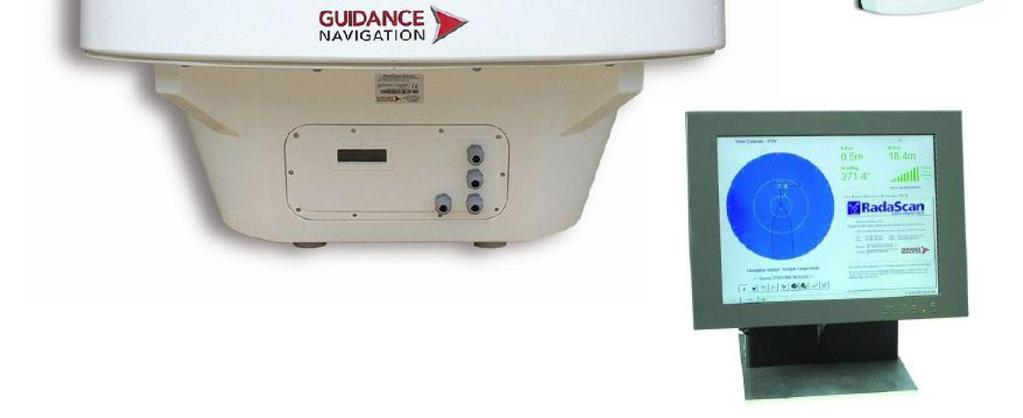
DYNAMIC POSITIONING CONFERENCE October 7-8, Sensors I. Field Applications and Environmental Challenges in the Use of Radascan
 Return to Session Directory DYNAMIC POSITIONING CONFERENCE October 7-8, 28 Sensors I Field Applications and Environmental Challenges in the Use of Radascan Dr. Dominic Pearce Guidance Navigation Ltd. (Leicester,
CODEVINTEC. Miniature and accurate IMU, AHRS, INS/GNSS Attitude and Heading Reference Systems
 45 27 39.384 N 9 07 30.145 E Miniature and accurate IMU, AHRS, INS/GNSS Attitude and Heading Reference Systems Aerospace Land/Automotive Marine Subsea Miniature inertial sensors 0.1 Ellipse Series New
Vincent/Enfield Conductor and Flowbase Installation Review. Roy Grant, TSMarine
 Vincent/Enfield Conductor and Flowbase Installation Review Roy Grant, TSMarine Project scope Offshore installation Mobilised in Dampier (KBSB) on 10 October TSMarine scope is onshore project management
Author s Name Name of the Paper Session. DYNAMIC POSITIONING CONFERENCE October 8-10, 2012 SENSORS II SESSION
 Author s Name Name of the Paper Session DYNAMIC POSITIONING CONFERENCE October 8-10, 2012 SENSORS II SESSION Acoustically Aided Inertial Navigation - Proven, Robust, and Efficient, Positioning Solutions
Challenging, innovative and fascinating
 O3b 2.4m antennas operating in California. Photo courtesy Hung Tran, O3b Networks Challenging, innovative and fascinating The satellite communications industry is challenging, innovative and fascinating.
Including GNSS Based Heading in Inertial Aided GNSS DP Reference System
 Author s Name Name of the Paper Session DYNAMIC POSITIONING CONFERENCE October 9-10, 2012 Sensors II SESSION Including GNSS Based Heading in Inertial Aided GNSS DP Reference System By Arne Rinnan, Nina
VESSEL IDENTIFICATION. Ready to work:
 The Nautical Geo is a research vessel available for worldwide operations. Fitted with cutting-edge survey equipment, she can undertake complex survey operations as well as light construction support, ensuring
PRINCIPLE OF SEISMIC SURVEY
 PRINCIPLE OF SEISMIC SURVEY MARINE INSTITUTE Galway, Ireland 29th April 2016 Laurent MATTIO Contents 2 Principle of seismic survey Objective of seismic survey Acquisition chain Wave propagation Different
Product description. High Precision Acoustic Positioning system
 Product description HiPAP 350 system High Precision Acoustic Positioning system Product description 855-164557 /AA000/N/A HiPAP 350 system High Precision Acoustic Positioning system This document describes
Hydrofest The Hydrographic Society in Scotland
 Hydrofest 2017 The Hydrographic Society in Scotland POSITIONING SYSTEMS Eddie Milne 1. GNSS Positioning 2. Additional Sensors 3. Alternative Positioning 4. Bringing it altogether GNSS = GPS + Glonass +
Inertial Sensors. Ellipse Series MINIATURE HIGH PERFORMANCE. Navigation, Motion & Heave Sensing IMU AHRS MRU INS VG
 Ellipse Series MINIATURE HIGH PERFORMANCE Inertial Sensors IMU AHRS MRU INS VG ITAR Free 0.1 RMS Navigation, Motion & Heave Sensing ELLIPSE SERIES sets up new standard for miniature and cost-effective
Side-Scan Sonar Presentation STS
 Training Module Side-Scan Sonar Presentation STS SIDE-SCAN SONAR SAFETY Training Module Content: This module includes information on: Types of Side-Scan Benefits and Disadvantages System Configuration
Moving Towards a Standardized Interface for Acoustic Inertial Reference Systems
 Author s Name Name of the Paper Session DYNAMIC POSITIONING CONFERENCE October 14-15, 2014 SENSORS SESSION Moving Towards a Standardized Interface for Acoustic Inertial Reference Systems By Mark Carter
Construction Survey Positioning Systems Wideband Fusion LBL and USBL
 cc Construction Survey Positioning Systems Wideband Fusion LBL and USBL Contents Introduction 01 Fusion USBL 02 Fusion USBL System Specifications 05 Fusion LBL 06 Fusion LBL System Specifications 09 Precise,
Deep. Navigating the. High Accuracy Positioning Support for Deep Water Construction. Copyright Journal of Ocean Technology 2017
 Navigating the Deep High Accuracy Positioning Support for Deep Water Construction by Will Primavesi, Tamir Frydenrych, and Drew Nicholson ISTOCKPHOTO.COM/CHERT61 The Journal of Ocean Technology, Vol. 12,
Sedco Express DGPS Operations Five Years of Lessons Learned
 Gabriel Delgado-Saldivar The Use of DP-Assisted FPSOs for Offshore Well Testing Services DYNAMIC POSITIONING CONFERENCE October 17-18, 2006 Risk Sedco Express DGPS Operations Five Years of Lessons Learned
Subsea Positioning In deep water
 Subsea Positioning In deep water PETRONAS - PETRAD - INTSOK CCOP DEEPWATER SUBSEA TIE-BACK Damai Puri Resort & Spa, Kuching, Sarawak, MALAYSIA 24TH - 26TH January, 2011 Supplier to the oil & gas industry
ROV/IMR - OFFSHORE SUPPORT VESSEL
 ROV/IMR - OFFSHORE SUPPORT VESSEL FUJIAN MAWEI DESIGN, 86.0M X 20.0M, 100T AHC CRANE, MOONPOOL, ABS +A1 (E), SPS, DPS 2, FIFI 1, ENVIRO, OIL REC Manager NORTRANS OFFSHORE II PTE LTD Class/Notation ABS
Author s Name Name of the Paper Session. DYNAMIC POSITIONING CONFERENCE October 10-11, 2017 SENSORS SESSION. Sensing Autonomy.
 Author s Name Name of the Paper Session DYNAMIC POSITIONING CONFERENCE October 10-11, 2017 SENSORS SESSION Sensing Autonomy By Arne Rinnan Kongsberg Seatex AS Abstract A certain level of autonomy is already
Inertial Sensors. Ellipse 2 Series MINIATURE HIGH PERFORMANCE. Navigation, Motion & Heave Sensing IMU AHRS MRU INS VG
 Ellipse 2 Series MINIATURE HIGH PERFORMANCE Inertial Sensors IMU AHRS MRU INS VG ITAR Free 0.1 RMS Navigation, Motion & Heave Sensing ELLIPSE SERIES sets up new standard for miniature and cost-effective
Inertial Systems. Ekinox 2 Series TACTICAL GRADE MEMS. Motion Sensing & Navigation IMU AHRS MRU INS VG
 Ekinox 2 Series TACTICAL GRADE MEMS Inertial Systems IMU AHRS MRU INS VG ITAR Free 0.02 RMS Motion Sensing & Navigation AEROSPACE GROUND MARINE EKINOX 2 SERIES R&D specialists usually compromise between
Inertial Navigation System
 Apogee Series ULTIMATE ACCURACY MEMS Inertial Navigation System INS MRU AHRS ITAR Free 0.005 RMS Motion Sensing & Georeferencing APOGEE SERIES makes high accuracy affordable for all surveying companies.
Inertial Sensors. Ellipse Series MINIATURE HIGH PERFORMANCE. Navigation, Motion & Heave Sensing IMU AHRS MRU INS VG
 Ellipse Series MINIATURE HIGH PERFORMANCE Inertial Sensors IMU AHRS MRU INS VG ITAR Free 0.2 RMS Navigation, Motion & Heave Sensing ELLIPSE SERIES sets up new standard for miniature and cost-effective
Motion Reference Units
 Motion Reference Units MRU Datasheet Rev. 1.3 IP-67 sealed 5% / 5 cm Heave accuracy 0.03 m/sec Velocity accuracy 0.05 deg Pitch and Roll accuracy 0.005 m/sec2 Acceleration accuracy 0.0002 deg/sec Angular
KONGSBERG seafloor-mapping echosounders
 KONGSBERG seafloor-mapping echosounders Berit Horvei WORLD CLASS through people, technology and dedication AGENDA Historical overview EM series Multibeam echosounder and Subbottom profiler Topside software.
MARINE TECHNOLOGY SOCIETY. DYNAMIC POSITIONING CONFERENCE, HOUSTON September 28-30, Advances in DGPS Systems
 Author s Name Name of the Paper Session MARINE TECHNOLOGY SOCIETY DYNAMIC POSITIONING CONFERENCE, HOUSTON September 28-30, 2004 Sensors Advances in DGPS Systems Ole Ørpen Fugro Seastar AS (Oslo, Norway)
A Precise Underwater Acoustic Positioning Method Based on Phase Measurement
 A Precise Underwater Acoustic Positioning Method Based on Phase Measurement by Li Zhou B. Eng., Northwestern Polytechnical University, 1996 M. Eng., Northwestern Polytechnical University, 1999 A Thesis
Acoustics Digital, Spread Spectrum, DSP, Wideband What does this mean for Real World DP Operations? Jonathan Davis Sonardyne Inc
 Subsea Positioning & Communications Acoustics Digital, Spread Spectrum, DSP, Wideband What does this mean for Real World DP Operations? Jonathan Davis Sonardyne Inc Outline Introduction Signal Processing
HiPAP HIGH PRECISION ACOUSTIC POSITIONING
 HiPAP HIGH PRECISION ACOUSTIC POSITIONING OUR MISSION We shall earn the respect and recognition for our dedication to provide innovative and reliable marine electronics that ensure optimal operation at
Autonomous Underwater Vehicle Navigation.
 Autonomous Underwater Vehicle Navigation. We are aware that electromagnetic energy cannot propagate appreciable distances in the ocean except at very low frequencies. As a result, GPS-based and other such
A Subsea Structural Deflection Monitoring System designed by RTS AS, Norway. 51st Marine Measurement Forum Adil Ali Seatronics Limited
 A Subsea Structural Deflection Monitoring System designed by RTS AS, Norway. 51st Marine Measurement Forum Adil Ali Seatronics Limited Seatronics and RTS Seatronics Limited : Established: 1978, Aberdeen-based
Simrad SX90 Long range high definition sonar system
 Simrad SX90 Long range high definition sonar system 360 omnidirectional sonar 90 vertical tip mode 20 to 30 KHz operational frequency Narrow beams Selectable beam width Hyperbolic FM Large dynamic range
SLAM Based Approach to Dynamic Ship Positioning
 http://www.transnav.eu the International Journal on Marine Navigation and Safety of Sea Transportation Volume 8 Number 1 March 2014 DOI: 10.12716/1001.08.01.02 SLAM Based Approach to Dynamic Ship Positioning
Easytrak Portable. Ultra-Short Base Line Navigation System. Operations Manual
 Easytrak Portable Ultra-Short Base Line Navigation System Operations Manual (For use with Win software Version 2.2 and above and the 902C Transducer only) Document Number EZT-2650-8002/7 Version: 7 2 Easytrak
Integration of an Inertial Navigation System and DP
 Return to Session Directory DYNAMIC POSITIONING CONFERENCE October 7-8, 28 Sensors II Integration of an Inertial Navigation System and DP Richard Stephens, Converteam UK Ltd. François Crétollier, IXSEA
INTEGRATED NAVIGATION SYSTEMS
 INTEGRATED NAVIGATION SYSTEMS Basic terms *integrated navigation system *control system *propulsion system *cargo system *digital processing unit *sensor *electronic circuits *sensor output *pulsed input
Motion Reference Units
 Motion Reference Units MRU IP-67 sealed 5% / 5 cm Heave accuracy 0.03 m/sec Velocity accuracy 0.05 deg Pitch and Roll accuracy 0.005 m/sec 2 Acceleration accuracy 0.0002 deg/sec Angular rate accuracy NMEA
NASNet DPR - NASNet as a deepwater acoustic DP position reference
 DYNAMIC POSITIONING CONFERENCE October 12-13, 2010 SENSORS I SESSION NASNet DPR - NASNet as a deepwater acoustic DP position reference By Sam Hanton DP Conference Houston October 12-13, 2010 Page 1 Introduction
Positioning Small AUVs for Deeper Water Surveys Using Inverted USBL
 Positioning Small AUVs for Deeper Water Surveys Using Inverted USBL Presented at Hydro12, Rotterdam, November 2012 Dr. T.M. Hiller, thiller@teledyne.com Overview Introduction to Gavia AUV Gavia Acoustic
DEVICE CONFIGURATION INSTRUCTIONS
 WinFrog Device Group: Device Name/Model: Device Manufacturer: Device Data String(s) Output to WinFrog: WinFrog Data String(s) Output to Device: WinFrog Data Item(s) and their RAW record: GPS POS/MV (NMEA)
Datawell BV. oceanographic instruments. Product catalogue January
 Datawell BV oceanographic instruments Product catalogue January 2018 www.datawell.nl Index Part 1 Buoys and accessories Directional Waverider... 4 Non-directional Waverider, Desk Top Waverider, Communication
GPS System Design and Control Modeling. Chua Shyan Jin, Ronald. Assoc. Prof Gerard Leng. Aeronautical Engineering Group, NUS
 GPS System Design and Control Modeling Chua Shyan Jin, Ronald Assoc. Prof Gerard Leng Aeronautical Engineering Group, NUS Abstract A GPS system for the autonomous navigation and surveillance of an airship
Brainstorm. In addition to cameras / Kinect, what other kinds of sensors would be useful?
 Brainstorm In addition to cameras / Kinect, what other kinds of sensors would be useful? How do you evaluate different sensors? Classification of Sensors Proprioceptive sensors measure values internally
PAP-240 Three Axis Antenna Pedestal and feed drive
 Présentation générale. ANTENNE MOTORISEE 3 AXES Versions : RxO Ku, RxO Ku&C (4 ports), RxTx Ku (2 ports), RxTx C (2 ports) PAP-240 Three Axis Antenna Pedestal and feed drive The two axis Motorized antenna
Hybrid system using both USBL and LBL for shallow waters
 OI2013 Underwater Positioning & Communication Hybrid system using both USBL and LBL for shallow waters Nicolas LARUELLE Sales Manager at OSEAN September 4th,2013 OI2013 Page 1 OVERVIEW SPECIFICATIONS PRINCIPLES
AUV Self-Localization Using a Tetrahedral Array and Passive Acoustics
 AUV Self-Localization Using a Tetrahedral Array and Passive Acoustics Nicholas R. Rypkema Erin M. Fischell Henrik Schmidt Background - Motivation Motivation: Accurate localization for miniature, low-cost
Motion & Navigation Solution
 Navsight Land & Air Solution Motion & Navigation Solution FOR SURVEYING APPLICATIONS Motion, Navigation, and Geo-referencing NAVSIGHT LAND/AIR SOLUTION is a full high performance inertial navigation solution
COMMAND-DEQ IBS Integrated Bridge System
 COMMAND-DEQ IBS Integrated Bridge System Page : 1 / 15 NAVIGATION BRIDGE 1 Navigation System 1.1 General The total Navigation System is based on «IBS» concept (Integrated Bridge System) The navigation
GNSS in the Arctic. by Arne Rinnan, Kongsberg Seatex AS. WORLD CLASS through people, technology and dedication
 GNSS in the Arctic by Arne Rinnan, Kongsberg Seatex AS WORLD CLASS through people, technology and dedication Outline Introduction Weather conditions Satellite coverage Aurora impact GNSS corrections Test
Emerging Subsea Networks
 INSTALLING SUBSEA STRUCTURES A SUCCESSFUL CABLE END MODULE CASE STUDY Paul Deslandes (Global Marine Systems Limited), Wayne Smith (Global Marine Systems Limited) Email: paul.deslandes@globalmarinesystems.com
GPS-Aided INS Datasheet Rev. 3.0
 1 GPS-Aided INS The Inertial Labs Single and Dual Antenna GPS-Aided Inertial Navigation System INS is new generation of fully-integrated, combined GPS, GLONASS, GALILEO, QZSS, BEIDOU and L-Band navigation
SeaWATCH ADCP. Self-Contained 300 khz / 600 khz / 1200 khz
 SeaWATCH ADCP Self-Contained 300 khz / 600 khz / 1200 khz The Rowe Technologies SeaWATCH product family is the most versatile self-contained Acoustic Doppler Current Profilers (ADCPs) and represent the
Dynamic Positioning System
 Dynamic Positioning System Dynamic Positioning System Features The Mega-Guard Dynamic Positioning System (DP) automatically controls a vessel s heading and position by activating thrusters based upon data
LBL POSITIONING AND COMMUNICATION SYSTEMS PRODUCT INFORMATION GUIDE
 LBL POSITIONING AND COMMUNICATION SYSTEMS PRODUCT INFORMATION GUIDE EvoLogics S2C LBL Underwater Positioning and Communication Systems EvoLogics LBL systems bring the benefi ts of long baseline (LBL) acoustic
The Signature VM package delivers vessel-mounted AD2CP capabilities based on present-day technology
 The package delivers vessel-mounted AD2CP capabilities based on present-day technology Until now, ADCP current surveys have been complex and time-consuming processes. A successful current survey depends
What is a GPS How does GPS work? GPS Segments GPS P osition Position Position Accuracy Accuracy Accuracy GPS A pplications Applications Applications
 What is GPS? What is a GPS How does GPS work? GPS Segments GPS Position Accuracy GPS Applications What is GPS? The Global Positioning System (GPS) is a precise worldwide radio-navigation system, and consists
SAR Interferometry Capabilities of Canada's planned SAR Satellite Constellation
 SAR Interferometry Capabilities of Canada's planned SAR Satellite Constellation Dirk Geudtner, Guy Séguin,, Ralph Girard Canadian Space Agency RADARSAT Follow-on Program CSA is in the middle of a Phase
Active microwave systems (2) Satellite Altimetry * range data processing * applications
 Satellite Altimetry * range data processing * applications") Remote Sensing: John Wilkin wilkin@marine.rutgers.edu IMCS Building Room 211C 732-932-6555 ext 251 Active microwave systems (2) Satellite Altimetry * range data processing * applications Satellite Altimeters
Remote Sensing: John Wilkin wilkin@marine.rutgers.edu IMCS Building Room 211C 732-932-6555 ext 251 Active microwave systems (2) Satellite Altimetry * range data processing * applications Satellite Altimeters
THE BRIEF FOR THE MAINTENANCE AND/OR INSTALLATION AND/OR PROVISION OF HYDRODYNAMIC EQUIPMENT
 THE BRIEF FOR THE MAINTENANCE AND/OR INSTALLATION AND/OR PROVISION OF HYDRODYNAMIC EQUIPMENT Scheme Title Employer s Address Nominated Employer s Representative Survey Title Purpose of Survey Specification
Simrad R5000 IMO/Solas Type Approved Radar Systems
 Simrad R5000 IMO/Solas Type Approved Radar Systems R5000 www.navico.com/commercial R5000 Radar Systems SIMRAD R5000 Radar Systems feature a modular plug & play design making it easy to create a cost effective
Subsea positioning through the ages
 Subsea positioning through the ages Jonathan Martin Navigation Systems Engineer Sonardyne International What is sound and how can we make use of it in navigation? Applied Voltage Induced Voltage The dawn
RV SIKULIAQ ALIGNMENT AND ORTHOGONAL COORDINATE SURVEY FINAL REPORT. March 5, 2016 Revision 2. Prepared By:
 RV SIKULIAQ ALIGNMENT AND ORTHOGONAL COORDINATE SURVEY FINAL REPORT March 5, 2016 Revision 2 Prepared By: The IMTEC Group, Ltd. 19004 E Ringo Circle Independence, MO 64057-1400 USA Phone 816-795-1782 Facsimile
USBL positioning and communication systems. Applications
 USBL positioning and communication systems Offering a powerful USBL transceiver functionality with full benefits of an S2C technology communication link Applications Positioning of offshore equipment >
SYSTEM 5900 SIDE SCAN SONAR
 SYSTEM 5900 SIDE SCAN SONAR HIGH-RESOLUTION, DYNAMICALLY FOCUSED, MULTI-BEAM SIDE SCAN SONAR Klein Marine System s 5900 sonar is the flagship in our exclusive family of multi-beam technology-based side
1 Introduction integrated 3D sonar system for underwater inspection applications
 1 Introduction The Underwater Inspection System (UIS TM ) is an integrated 3D sonar system for underwater inspection applications, specifically port and harbor construction, maintenance, port expansion,
9/12/2011. Training Course Remote Sensing Basic Theory & Image Processing Methods September 2011
 Training Course Remote Sensing Basic Theory & Image Processing Methods 19 23 September 2011 Remote Sensing Platforms Michiel Damen (September 2011) damen@itc.nl 1 Overview Platforms & missions aerial surveys
Gyrocompass and motion sensor. octans. navigation and positioning
 Gyrocompass and motion sensor octans navigation and positioning the best in fog technology The technological heart of is the Fibre-Optic Gyroscope (FOG), the only truly-solid-state answer to rotation sensing.
Surveillanca & Security DIGITAL DUAL BAND ARPA RADAR SYSTEM
 Surveillanca & Security DIGITAL DUAL BAND ARPA RADAR SYSTEM X-band K a -band GEMINI-DB digital dual-band ARPA radar offers operational advantages and flexibility of operations thanks to the simultaneous
USBL positioning and communication SyStEmS. product information GUidE
 USBL positioning and communication SyStEmS product information GUidE evologics s2c R usbl - series underwater positioning and communication systems EvoLogics S2CR USBL is a series of combined positioning
TECHNICAL AND OPERATIONAL GUIDANCE (TECHOP) TECHOP_ODP_14_(D) (PRS AND DPCS HANDLING OF PRS) SEPTEMBER 2017
 TECHOP_ODP_14_(D) (PRS AND DPCS HANDLING OF PRS) SEPTEMBER 2017") TECHNICAL AND OPERATIONAL GUIDANCE (TECHOP) TECHOP_ODP_14_(D) (PRS AND DPCS HANDLING OF PRS) SEPTEMBER 2017 TECHOP_ODP_14_(D)_PRS & DPCS HANDLING OF PRS_Ver3-09201714 1 DISCLAIMER AND LIMITATION OF LIABILITY
TECHNICAL AND OPERATIONAL GUIDANCE (TECHOP) TECHOP_ODP_14_(D) (PRS AND DPCS HANDLING OF PRS) SEPTEMBER 2017 TECHOP_ODP_14_(D)_PRS & DPCS HANDLING OF PRS_Ver3-09201714 1 DISCLAIMER AND LIMITATION OF LIABILITY
GPS-Aided INS Datasheet Rev. 2.3
 GPS-Aided INS 1 The Inertial Labs Single and Dual Antenna GPS-Aided Inertial Navigation System INS is new generation of fully-integrated, combined L1 & L2 GPS, GLONASS, GALILEO and BEIDOU navigation and
AN AIDED NAVIGATION POST PROCESSING FILTER FOR DETAILED SEABED MAPPING UUVS
 MODELING, IDENTIFICATION AND CONTROL, 1999, VOL. 20, NO. 3, 165-175 doi: 10.4173/mic.1999.3.2 AN AIDED NAVIGATION POST PROCESSING FILTER FOR DETAILED SEABED MAPPING UUVS Kenneth Gade and Bjørn Jalving