INTEGRATED NAVIGATION SYSTEMS
|
|
|
- Bennett Marshall
- 6 years ago
- Views:
Transcription
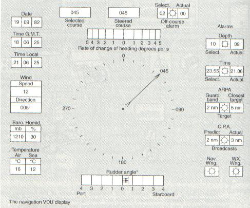
1 INTEGRATED NAVIGATION SYSTEMS Basic terms *integrated navigation system *control system *propulsion system *cargo system *digital processing unit *sensor *electronic circuits *sensor output *pulsed input *master navigation unit *speed over ground *speed through the water *inclinometer *alarm systems *VDU Visual Display Unit *Satnav Receiver *display *GPS Global Positioning System *Omega/Loran Receiver *Coverage *Decca *RDF *anti-collision radar A modern integrated control system aims to enable one watch-keeping officer to control the ship's navigation, her propulsion system and the cargo spaces. At its heart there is a digital processing unit which is interfaced with multiple sensors. Recent advances in electronic navigation apparatus and circuits have provided a suitable sensor output switch which can be integrated into one master navigation unit. The input data required for a safe and economical navigation and for an integrated navigation system are available from: - a heading sensor, i.e. pulses from a gyroscopic compass including the correction of gyro errors - a velocity sensor providing a pulsed input from a dual axis speed log, with corrections for the differeoce in speed over ground (SOG) and speed through the water - sea water temperature anti-salinity sensors - a pitch and roll sensor, with an electronic inclinometer compensating for changes in the indicated speed - a depth sensor (e.g. output from an echo sounder displayed on the VDU) - Satellite Navigation Receiver. Output of a single or dual channel receiver is used to update the DR position - GPS - global positioning system - Omega/Loran-C Receiver (regional and worldwide coverage) - Decca or other local navigation system - RDF interfaced to the master unit - Radar. Processed data from both 3 or 10 cm (s and x band) - anti-collision radar is of vital importance for the safe passage of a vessel (ARPA) - Auto-Pilot, with a rudder movement indicator - Satcom In addition to these sensors the integrated navigation system may also include memory, engine and fuel sensors, cargo sensors, various alarm systems. Likewise, a display of weather forecasts and warnings as well as of reports to navigators are available via satellite. Port information may be included, too. The most popular systems in use today are GPS/Transit, Loran/GPS and Satnav + Omega with interfaces from a gyro compass and speed log.
2 Nauto Control stands for system and hardware modularity of the functional units: Operation Control System, Automatic System and Steering Control System. System extensions can be realized for specific applications (see funcional diagram)
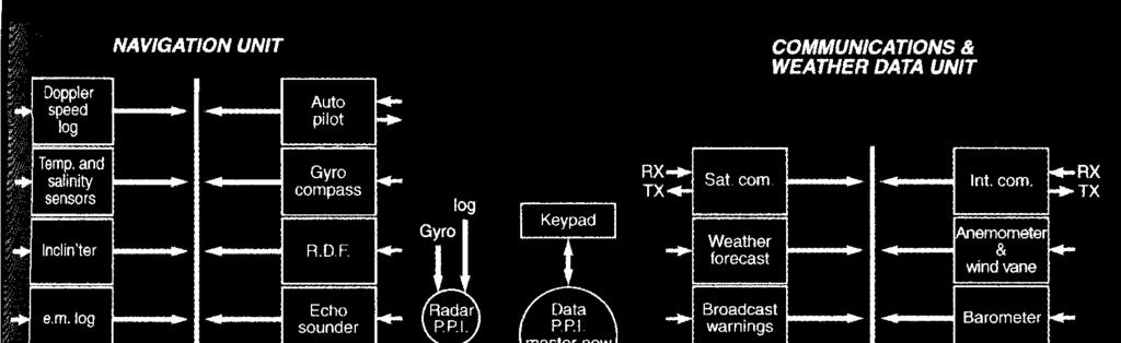
3 Integrated navigation systems Architecture of a complete integrated system
4 A simplified overall functional block diagram of Magnavox MX 1105 A. Comprehension & vocabulary A.1 Study the drawing (Integrated navigation systems) and describe the navigation VDU display: A.2 Complete the following sentences: l. The speed data is obtained from. 2. Data from the inclinometer is used to. 3. Omega is preferred to Loran-C because. 4. Decca is interfaced when sailing in. 5. Satnav input data are used to. 6. Time display, accurate to one second GMT, is derived from. 7. For display on the radar PPI we can interswitch radar types such as.
5 A.3 Study the drawing (Architecture of a complete integrated system) and describe the four units of the ship's integrated control system: A.4 Explain the following abbreviations: VDU GPS SOG COG DR Satnav LORAN Satcom ARPA RADAR UTC RDF B. Grammar B.1 Rewrite the sentences putting the verbs in brackets in the correct place in the sentence. Magnavox MX 4400 GPS & navigation systems POS present position (show). It also altitude by GPS (display) and entered altitude above mean sea level. PLAN This function for planning operations (use) which GPS satellite coverage (require). It also rise and set times of 2, 3, or 4 satellite constellations for any specified location and date (show). NAV course and speed over the ground (display). WPT the operator set and review the location of up to 30 waypoints (let). DEST range and bearing to the intended waypoint, which is a Rhumb Line or Great Circle (display). It also heading to steer to at a specified waypoint (show, arrive). ETA at the specified waypoint also (display). TIME as UTC or LT (show). KYBD the operator to select desired level of keyboard and display illumination (enable). B.2 Find the words in the reading text that have the function (attributive) of an adjective: EXAMPLE ship s navigation (possessive case of the noun ship ) propulsion unit (noun propulsion )
UNIT 26 ELECTRONIC AIDS TO NAVIGATION
 UNIT 26 ELECTRONIC AIDS TO NAVIGATION Basic terms aid to navigation >Loran-C >Omega >Transit satellite >GPS >hyperbolic systems > satellite navigation system >fix accuracy small-screen >satnav receiver
CONTENTS CONTENTS...1 USING THE LIGHTS KEY... 16
 CONTENTS CONTENTS...1 GENERAL INTRODUCTION TO B&G NETWORK...2 INTRODUCTION TO NETWORK NAV...3 NETWORK NMEA INTERFACING RULES...5 SYSTEMS WITH MULTIPLE NAV UNITS...5 INTERFACING NETWORK NAV AND PILOT...6
CONTENTS. INTRODUCTION 1 INTRODUCTION TO GPSPlus 3
 CONTENTS INTRODUCTION 1 INTRODUCTION TO GPSPlus 3 OPERATION OF GPSPlus 5 INTRODUCTION 6 SWITCHING ON 6 INITIAL DISPLAYS 6 USING THE LIGHTS KEY 7 NOTES ABOUT ENTERING DATA 7 USING THE POS KEY 8 USING WAYPOINTS
Universidad Nacional Experimental Marítima del Caribe Vicerrectorado Académico Cátedra de Idiomas Inglés VI. Ingeniería Marítima
 Universidad Nacional Experimental Marítima del Caribe Vicerrectorado Académico Cátedra de Idiomas Inglés VI. Ingeniería Marítima UNIT II. Navigational equipment found onboard ships. Speaking. 1. Can you
Is the new technology safe for navigation in coastal waters and archipelagos?
 3.35.20 Is the new technology safe for navigation in coastal waters and archipelagos? As near misses not are reported we take a look at the groundings Combat boat CB 90 (mostly) Thank you Lars-Erik! ECS
Saab TransponderTech
 Saab TransponderTech R4 Combined AIS & Navigation System This page is intentionally empty Copyright The content of this document and its attachments shall remain our property. They may not without our
ANNEX 12. RESOLUTION MSC.74(69) (adopted on 12 May 1998) ADOPTION OF NEW AND AMENDED PERFORMANCE STANDARDS
 (adopted on 12 May 1998) ADOPTION OF NEW AND AMENDED PERFORMANCE STANDARDS") RESOLUTION MSC.74(69) (adopted on 12 May 1998) ADOPTION OF NEW AND AMENDED PERFORMANCE STANDARDS THE MARITIME SAFETY COMMITTEE, RECALLING Article 28(b) of the Convention on the International Maritime Organization
RESOLUTION MSC.74(69) (adopted on 12 May 1998) ADOPTION OF NEW AND AMENDED PERFORMANCE STANDARDS THE MARITIME SAFETY COMMITTEE, RECALLING Article 28(b) of the Convention on the International Maritime Organization
COMMAND-DEQ IBS Integrated Bridge System
 COMMAND-DEQ IBS Integrated Bridge System Page : 1 / 15 NAVIGATION BRIDGE 1 Navigation System 1.1 General The total Navigation System is based on «IBS» concept (Integrated Bridge System) The navigation
Addendum 1.4_2. (Addendum to MX420 Operator s Manual)
") _2 (Addendum to MX420 ) September, 2007 Table of Contents About this document..1 MX575 Heading & Rate of Turn 2 MX575 as a D/GPS Compass only 2 MX575 as a D/GPS Compass with Navigation Functionality.....4
_2 (Addendum to MX420 ) September, 2007 Table of Contents About this document..1 MX575 Heading & Rate of Turn 2 MX575 as a D/GPS Compass only 2 MX575 as a D/GPS Compass with Navigation Functionality.....4
OPERATOR'S MANUAL. Electronic Chart Display and Information System (ECDIS) FEA-2107-BB FEA-2107-D FEA-2807
 FEA-2107-BB FEA-2107-D FEA-2807") OPERATOR'S MANUAL Electronic Chart Display and Information System (ECDIS) FEA-2107 FEA-2107-BB FEA-2107-D FEA-2807 MODEL FEA-2807-D Instructions for use with Autopilots: FAP-2000 PT-500A(CAT B, CAT C)
OPERATOR'S MANUAL Electronic Chart Display and Information System (ECDIS) FEA-2107 FEA-2107-BB FEA-2107-D FEA-2807 MODEL FEA-2807-D Instructions for use with Autopilots: FAP-2000 PT-500A(CAT B, CAT C)
NMEA2000- Par PGN. Mandatory Request, Command, or Acknowledge Group Function Receive/Transmit PGN's
 PGN Number Category Notes - Datum Local geodetic datum and datum offsets from a reference datum. T The Request / Command / Acknowledge Group type of 126208 - NMEA - Request function is defined by first
A new Modular and Open Concept for the Maritime Integrated PNT System
 A new Modular and Open Concept for the Maritime Integrated PNT System T. Noack German Aerospace Center Institute of Communications and Navigation www.dlr.de Chart 2 MTS-2012 Maritime Integrated PNT Unit
NMEA 2000 Parameter Group Numbers and Description as of August 2007 NMEA 2000 DB Ver
 Category General & or Mandatory ISO Acknowledgment This message is provided by ISO 11783 for a handshake mechanism between transmitting and receiving devices. This message is the possible response to acknowledge
ECDIS and MANTADIGITAL. PLUS
 TM MANTADIGITAL ECDIS and PLUS 2011/2012 www.ecdisplus.com Introduction What is an ECDIS? ECDIS is an acronym for Electronic Chart Display and Information System. At its simplest, an ECDIS consists of
The human touch in technology. ECDIS ECS Conning screen Ship speed info system
 The human touch in technology ECDIS ECS Conning screen Ship speed info system Alphatron ALPHACHART T ECDIS Type approved ECDIS system powered by TRANSAS The ALPHACHART T is an advanced Electronic Chart
e-navigation Underway International February 2016 Kilyong Kim(GMT Co., Ltd.) Co-author : Seojeong Lee(Korea Maritime and Ocean University)
 Co-author : Seojeong Lee(Korea Maritime and Ocean University)") e-navigation Underway International 2016 2-4 February 2016 Kilyong Kim(GMT Co., Ltd.) Co-author : Seojeong Lee(Korea Maritime and Ocean University) Eureka R&D project From Jan 2015 to Dec 2017 15 partners
e-navigation Underway International 2016 2-4 February 2016 Kilyong Kim(GMT Co., Ltd.) Co-author : Seojeong Lee(Korea Maritime and Ocean University) Eureka R&D project From Jan 2015 to Dec 2017 15 partners
TECHNICAL SPECIFICATION. VisionMaster FT Radar & Chart Radar Features CAT1 and ECAT2
 TECHNICAL SPECIFICATION VisionMaster FT Radar & Chart Radar Features CAT1 and ECAT2 The following specifications relate to release 4.1.3 series of VisionMaster FT (IEC62388 version) RADAR SYSTEM PERFORMANCE
Sperry Marine Northrop Grumman
 Sperry Marine 2005 Northrop Grumman Table of Contents CHAPTER 1: CHAPTER 2: CHAPTER 3: CHAPTER 4: CHAPTER 5: CHAPTER 6: WHERE ARE YOU GOING? TRANSMITTING HEADING DEVICES DETERMINING HEADING BY SATELLITE
Maritime Electronics Supporting Unmanned Vessels
 EU-Japan Policy Workshop Maritime Electronics Supporting Unmanned Vessels November 11 th, 2016 TAKUO KASHIWA, Ph.D Furuno Electric Co., Ltd. Agenda Positioning Technologies for Vessel s position Technologies
Simrad CE40/42/50 MKII DGPS ChartSounder
 Simrad CE40/42/50 MKII DGPS ChartSounder 183.0100.202 English 01154.05 Note! Insert or remove C-MAP cartridges ONLY through CHART menu or when unit is off. All electronic navigation equipment is subject
dkart Navigator 9010
 dkart Navigator 9010 dkart Navigator - purpose dkart Navigator is an electronic navigation chart system specially designed to facilitate all the navigational tasks of mariner's day-to-day practice. Along
Real-time position tracking of traffic ships by ARPA radar and AIS in Busan Harbor, Korea
 J Kor Soc Fish Tech 44(3) 229 238 2008 DOI:103796/KSFT2008443229 Real-time position tracking of traffic ships by radar and in Busan Harbor Korea Dae-Jae LEE* Division of Marine Production System Management
R4 AIS Class A Transponder System
 Saab TransponderTech R4 AIS Class A Transponder System Operator Manual This page is intentionally empty i Copyright The entire contents of this manual and its appendices, including any future updates and
The human touch in technology. Maintenance free Fiber Optic Gyro compass ALPHAFIBERCOURSE
 The human touch in technology Maintenance free Fiber Optic Gyro compass ALPHAFIBERCOURSE ALPHAFIBERCOURSE GYRO COMPASS STATE OF THE ART FOG (FIBER OPTIC) STRAPDOWN TECHNOLOGY HEADING, ROLL, PITCH AND RATE
Transport System. Telematics. Possibility of integration of navigational information on electronic chart
 Archives of Volume 3 Transport System Issue 2 Telematics May 2010 Possibility of integration of navigational information on electronic chart H. ŚNIEGOCKI a, M. WIELIKI b a Faculty of Navigation, Gdynia
GUIDELINES ON THE DESIGN AND USE OF PORTABLE PILOT UNITS INTERNATIONAL MARITIME PILOTS ASSOCIATION
 GUIDELINES ON THE DESIGN AND USE OF PORTABLE PILOT UNITS INTERNATIONAL MARITIME PILOTS ASSOCIATION WITH TECHNICAL INPUT FROM Comité International Radio-Maritime (CIRM) 2 FOREWORD With the increasing use
The Impact of IT on the. Marine Navigator. Andrew Eccleston. University of Plymouth
 The Impact of IT on the Marine Navigator Andrew Eccleston University of Plymouth Marine Navigators with local connections Sir Francis Drake Sir Francis Chichester Tasksfor the Marine Navigator Navigation
TECHNICAL COMMITTEE 80: MARITIME NAVIGATION AND RADIOCOMMUNICATION EQUIPMENT AND SYSTEMS INTERNATIONAL ELECTROTECHNICAL COMMISSION
 TECHNICAL COMMITTEE 80: MARITIME NAVIGATION AND RADIOCOMMUNICATION EQUIPMENT AND SYSTEMS INTERNATIONAL ELECTROTECHNICAL COMMISSION IEC TECHNICAL COMMITTEE 80: MARITIME NAVIGATION AND RADIOCOMMUNICATION
The FA-30 delivers Real-Time AIS information to navigation systems providing critical collision avoidance information
 The FA-30 delivers Real-Time AIS information to navigation systems providing critical collision avoidance information Acquisition and tracking of traffic around your vessel is absolutely necessary for
AIS Training. AIS Technology in Digital Yacht Products Explained. Digital Yacht Ltd TEL
 AIS Training AIS Technology in Digital Yacht Products Explained Digital Yacht Ltd www.digitalyacht.co.uk TEL + 44 1179 554474 What is AIS? The Automatic Identification System (AIS) is the biggest advance
Port Security and Technology - the U.S. Perspective. Michael S. Bruno Stevens Institute of Technology March 14, 2012
 Port Security and Technology - the U.S. Perspective Michael S. Bruno Stevens Institute of Technology March 14, 2012 CSR A Department of Homeland Security National Center of Excellence for Port Security
RESOLUTION MSC.278(85) (adopted on 1 December 2008) ADOPTION OF THE NEW MANDATORY SHIP REPORTING SYSTEM "OFF THE COAST OF PORTUGAL - COPREP"
 (adopted on 1 December 2008) ADOPTION OF THE NEW MANDATORY SHIP REPORTING SYSTEM OFF THE COAST OF PORTUGAL - COPREP") MSC 85/26/Add.1 RESOLUTION MSC.278(85) SYSTEM OFF THE COAST OF PORTUGAL COPREP THE MARITIME SAFETY COMMITTEE, RECALLING Article 28 of the Convention on the International Maritime Organization concerning
MSC 85/26/Add.1 RESOLUTION MSC.278(85) SYSTEM OFF THE COAST OF PORTUGAL COPREP THE MARITIME SAFETY COMMITTEE, RECALLING Article 28 of the Convention on the International Maritime Organization concerning
THE ELECTRONIC CHART DISPLAY AND INFORMATION SYSTEM (ECDIS) IN CHINA
 IN CHINA") International Hydrographic 'Review, Monaco, LXIX(2), September 1992 THE ELECTRONIC CHART DISPLAY AND INFORMATION SYSTEM (ECDIS) IN CHINA by The Research Group on ECDIS 1 Abstract This paper presents a
International Hydrographic 'Review, Monaco, LXIX(2), September 1992 THE ELECTRONIC CHART DISPLAY AND INFORMATION SYSTEM (ECDIS) IN CHINA by The Research Group on ECDIS 1 Abstract This paper presents a
Introducing The World s First DGPS/AIS Navigation System!
 Introducing The World s First DGPS/AIS Navigation System! MX420 Navigation System: The Most Advanced DGPS/AIS Navigation Solution. MX420AIS Pioneering The Future Standards Of Navigation All navigation
CHARTRADAR 1000 Brilliant Colour Radars with Chart Facilities
 CHARTRADAR 1000 Brilliant Colour Radars with Chart Facilities Introduction The CHARTRADAR 1000 combines the outstanding features of the RADARPILOT with the CHARTPILOT state-of-the-art ENC presentation.
GUIDELINES ON ANNUAL TESTING OF THE AUTOMATIC IDENTIFICATION SYSTEM (AIS)
") INTERNATIONAL MARITIME ORGANIZATION 4 ALBERT EMBANKMENT LONDON SE1 7SR Telephone: 020 7735 7611 Fax: 020 7587 3210 IMO E Ref. T1/10 MSC.1/Circ.1252 22 October 2007 GUIDELINES ON ANNUAL TESTING OF THE AUTOMATIC
INTERNATIONAL MARITIME ORGANIZATION 4 ALBERT EMBANKMENT LONDON SE1 7SR Telephone: 020 7735 7611 Fax: 020 7587 3210 IMO E Ref. T1/10 MSC.1/Circ.1252 22 October 2007 GUIDELINES ON ANNUAL TESTING OF THE AUTOMATIC
FLCS V2.1. AHRS, Autopilot, Gyro Stabilized Gimbals Control, Ground Control Station
 AHRS, Autopilot, Gyro Stabilized Gimbals Control, Ground Control Station The platform provides a high performance basis for electromechanical system control. Originally designed for autonomous aerial vehicle
SANDHAYAK CLASS A NEW CLASS OF INDIAN SURVEYING SHIP
 Intern a tio n a l H ydrographic Review, Monaco, LXI (I), January 1984 SANDHAYAK CLASS A NEW CLASS OF INDIAN SURVEYING SHIP by the Indian Naval Hydrographic Office'* In 1973, the Government of India approved
CENG 5931 HW 5 Mobile Robotics Due March 5. Sensors for Mobile Robots
 CENG 5931 HW 5 Mobile Robotics Due March 5 Sensors for Mobile Robots Dr. T. L. Harman: 281 283-3774 Office D104 For reports: Read HomeworkEssayRequirements on the web site and follow instructions which
DP MAINTENANCE INTRODUC INTR TION T TION O SENS T OR O SENS S OR
 DP MAINTENANCE INTRODUCTION TO SENSORS Sensors Wind Sensors PMEs Workstations Gyrocompasses Network Switchbox Network Switchbox Controller Cabinets Dual Ethernet Motion Sensors (VRU) Field Stations Thrusters
Dynamic Sensor. JLR-31 GPS compass RMS. the JLR-31 sets a new standard of GPS compass, with its renowned high performance and new features
 GPS compass Dynamic Sensor 3D RMS the JLR-31 sets a new standard of GPS compass, with its renowned high performance and new features 5.7-inch high visibility display Roll, pitch, rate of turn and heave
Date of issue: Version 01. December TRANSAS ISAILOR Functional comparison on ios and Android platforms.
 Date of issue: Version 01. December 2017 TRANSAS ISAILOR Functional comparison on ios and Android platforms. TRANSAS ISAILOR 2 1991 2017 Transas Marine Ltd. All rights reserved. The information contained
Table of Contents. Installing to the Main Body.103
 Table of Contents 1. GPS Overview...2 2. Features...3 1. GPS Antenna & Receiver...4 2. Main Unit Features & Functions...4 3. Standard Scope of Supply...7 3. Device & Display...8 1. Display Device...8 2.
Inertial Systems. Ekinox Series TACTICAL GRADE MEMS. Motion Sensing & Navigation IMU AHRS MRU INS VG
 Ekinox Series TACTICAL GRADE MEMS Inertial Systems IMU AHRS MRU INS VG ITAR Free 0.05 RMS Motion Sensing & Navigation AEROSPACE GROUND MARINE EKINOX SERIES R&D specialists usually compromise between high
IS Shore Based Maintenance. Definition and Pricing
 IS Shore Based Maintenance Definition and Pricing Content 1 IS SBM Basic - Mandatory Annual Tests... 3 2 IS SBM Basic Com - Mandatory Annual Tests plus Communication Equipment... 4 3 IS SBM Nav - Mandatory
2.017 DESIGN OF ELECTROMECHANICAL ROBOTIC SYSTEMS Fall 2009 Lab 3: GPS and Data Logging. September 28, 2009 Dr. Harrison H. Chin
 2.017 DESIGN OF ELECTROMECHANICAL ROBOTIC SYSTEMS Fall 2009 Lab 3: GPS and Data Logging September 28, 2009 Dr. Harrison H. Chin Formal Labs 1. Microcontrollers Introduction to microcontrollers Arduino
Keywords. DECCA, OMEGA, VOR, INS, Integrated systems
 Keywords. DECCA, OMEGA, VOR, INS, Integrated systems 7.4 DECCA Decca is also a position-fixing hyperbolic navigation system which uses continuous waves and phase measurements to determine hyperbolic lines-of
Using a Pilot Laptop with the AIS pilot plug - observed errors and difficulties
 Using a Pilot Laptop with the AIS pilot plug - observed errors and difficulties 2 nd November 2008 The following pages and images detail the errors found and experience in using his Pilot Laptop by a Australian
The Captains F O R U M
 The Captains F O R U M THE HUMAN-CENTRED DESIGN FORUM In December last year, the International Maritime Organization (IMO) adopted Performance Standards and approved Guidelines the combined effect of which
NAVIGATION INSTRUMENTS - BASICS
 NAVIGATION INSTRUMENTS - BASICS 1. Introduction Several radio-navigation instruments equip the different airplanes available in our flight simulators software. The type of instrument that can be found
Generic Bathymetry Data - Interface Control Document
 Generic Bathymetry Data - Interface Control Document For WASSP Prepared by: Keith Fletcher Electronic Navigation Ltd October 15, 2013 Version 2.2 2013 by WASSP Ltd No part of this document should be reproduced
Manual. Simrad NX40/45 NavStation. English Sw. 2.7
 Manual Simrad NX40/45 NavStation English Sw. 2.7 www.simrad-yachting.com A brand by Navico - Leader in Marine Electronics Warning It is your sole responsibility to install and use the instrument and transducer(s)
Surveillanca & Security DIGITAL DUAL BAND ARPA RADAR SYSTEM
 Surveillanca & Security DIGITAL DUAL BAND ARPA RADAR SYSTEM X-band K a -band GEMINI-DB digital dual-band ARPA radar offers operational advantages and flexibility of operations thanks to the simultaneous
NAVIGAT Fiber-Optic Gyrocompass and Attitude Reference System. Sperry Marine. The Dynamic Solution for a Demanding Challenge
 NAVIGAT 2100 Fiber-Optic Gyrocompass and Attitude Reference System Sperry Marine The Dynamic Solution for a Demanding Challenge NAVIGAT 2100 Fiber-Optic Gyrocompass and Attitude Fiber-Optic Sensor Unit
Engtek SubSea Systems
 Engtek SubSea Systems A Division of Engtek Manoeuvra Systems Pte Ltd SubSea Propulsion Technology AUV Propulsion and Maneuvering Modules Engtek SubSea Systems A Division of Engtek Manoeuvra Systems Pte
GPS NAVIGATOR GP-150
 GPS NAVIGATOR GP-150 The paper used in this manual is elemental chlorine free. FURUNO Authorized Distributor/Dealer 9-52 Ashihara-cho, Nishinomiya 662-8580, JAPAN Telephone : 0798-65-2111 Fax : 0798-65-4200
Simulator. Demo mode. Simulator source files. 102 Simulator HDS Gen3 Operator Manual
 13 Simulator The simulation feature lets you see how the unit works in a stationary position and without being connected to sensors or other devices. Demo mode In this mode the unit automatically runs
Brief installation guide for FA-100 Universal AIS
 Attention: All Furuno Distributors Date: April 2, 2003 SB No: FSB02-0002 Number of Pages: 5 Brief installation guide for FA-100 Universal AIS The purpose of this document is to provide and highlight important
AIS6 / MFR6 User Manual
 AIS6 / MFR6 User Manual Important Features at a glance Below you will find a brief summary of the main features of your Seatec AIS6 / MFR6. Your Seatec AIS6 / MFR6 will be your reliable partner for a safe
السلطة البحرية االردنية Jordan Maritime Authority
 السلطة البحرية االردنية السلطة البحرية االردنية Humans have always been interested in where things are السلطة البحرية االردنية One of the basic questions have always been where I am? which leads to where
CHAPTER 66 QUARTERMASTER (QM) NAVPERS E CH-67
 NAVPERS E CH-67") CHAPTER 66 QUARTERMASTER (QM) NAVPERS 18068-66E CH-67 Updated: July 2016 TABLE OF CONTENTS QUARTERMASTER (QM) SCOPE OF RATING GENERAL INFORMATION NAVIGATION ADMINISTRATOR COMMUNICATIONS ELECTRONIC SYSTEMS
CHAPTER 66 QUARTERMASTER (QM) NAVPERS 18068-66E CH-67 Updated: July 2016 TABLE OF CONTENTS QUARTERMASTER (QM) SCOPE OF RATING GENERAL INFORMATION NAVIGATION ADMINISTRATOR COMMUNICATIONS ELECTRONIC SYSTEMS
Simrad R5000 IMO/Solas Type Approved Radar Systems
 Simrad R5000 IMO/Solas Type Approved Radar Systems R5000 www.navico.com/commercial R5000 Radar Systems SIMRAD R5000 Radar Systems feature a modular plug & play design making it easy to create a cost effective
A WINDOWS INTERFACE FOR MARITIME NAVIGATION TRAINING
 An. Şt. Univ. Ovidius Constanţa Vol. 11(1), 2003, 161 168 A WINDOWS INTERFACE FOR MARITIME NAVIGATION TRAINING Gheorghe Popescu To Professor Silviu Sburlan, at his 60 s anniversary Abstract This report
FLUXGATE COMPASS. Product reference : USER GUIDE. and INSTALLATION GUIDE. nke Sailing competition
 FLUXGATE COMPASS Product reference : 90-60-452 USER GUIDE and INSTALLATION GUIDE nke Sailing competition Z.I. Kerandré Rue Gutenberg 56700 HENNEBONT- FRANCE http://www.nke.fr N indigo 0 892 680 656 : 0,34
1. Introduction. Quick Start Guide for GPS150 V1.02 TEL
 1. Introduction Congratulations on the purchase of your GPS150 Smart GPS/GLONASS Sensor. It is recommended that your receiver is installed by a professional installer. You will need to purchase a suitable
Dynamically Positioned and Thruster Assisted Position Moored Vessels
 Dynamically Positioned and Thruster Assisted Position Moored Vessels Professor Asgeir J. Sørensen, Department of Marine Technology, Norwegian University of Science and Technology, Otto Nielsens Vei 10,
COMPANY RESTRICTED NOT EXPORT CONTROLLED NOT CLASSIFIED Your Name Document number Issue X FIGHTING THE BATTLE. Thomas Kloos, Björn Bengtsson
 FIGHTING THE BATTLE Thomas Kloos, Björn Bengtsson 2 THE 9LV COMBAT SYSTEM FIRST TO KNOW, FIRST TO ACT Thomas Kloos, Naval Business Development Business Unit Surveillance 9LV 47,5 YEARS OF PROUD HISTORY
LT Matthew Forney, NOAA Navigation Manager Alaska Region Bering Strait MaritimeSymposium. Office of Coast Survey
 NOAA LT Matthew Forney, NOAA Navigation Manager Alaska Region Bering Strait MaritimeSymposium Who is Coast Survey? First science agency of the U.S. Formed in 1807 Responsible for surveying 3.4 million
Resilient PNT: From PNT-Unit concept to first realization
 www.dlr.de Chart 1 >Resilient PNT: From PNT Unit concept to first realization> R. Ziebold > e-navigation Underway 1/3/213 Resilient PNT: From PNT-Unit concept to first realization Ralf Ziebold, Z. Dai,
NC Models. CP390i - GPS Chart Plotters. Addendum to Owner s Manual Issue C to update to Software Version (*)
") CP390i - GPS Chart Plotters (*) NC Models to Owner s Manual Issue 16.50 C 300311 to update to Software Version 16.70 BUILT-IN CHARTS ARE NOT INSTALLED The following paragraphs/pictures are not applicable:
CP390i - GPS Chart Plotters (*) NC Models to Owner s Manual Issue 16.50 C 300311 to update to Software Version 16.70 BUILT-IN CHARTS ARE NOT INSTALLED The following paragraphs/pictures are not applicable:
Autonnic Research develops and manufactures unique marine electronic components, sensors and instruments which perform reliably in the harshest
 Autonnic Research develops and manufactures unique marine electronic components, sensors and instruments which perform reliably in the harshest offshore conditions. The Company Since its inception in 1963
Kongsberg Seatex AS Pirsenteret N-7462 Trondheim Norway POSITION 303 VELOCITY 900 HEADING 910 ATTITUDE 413 HEAVE 888
 WinFrog Device Group: Device Name/Model: Device Manufacturer: Device Data String(s) Output to WinFrog: WinFrog Data String(s) Output to Device: WinFrog Data Item(s) and their RAW record: GPS SEAPATH Kongsberg
NAVIGATION (2) RADIO NAVIGATION
 RADIO NAVIGATION") 1 An aircraft is "homing" to a radio beacon whilst maintaining a relative bearing of zero. If the magnetic heading decreases, the aircraft is experiencing: A left drift B right drift C a wind from the
1 An aircraft is "homing" to a radio beacon whilst maintaining a relative bearing of zero. If the magnetic heading decreases, the aircraft is experiencing: A left drift B right drift C a wind from the
Meridian Gyrocompasses
 TELEDYNE TSS WORLD LEADERS IN MARINE INSTRUMENTATION Meridian Gyrocompasses MARINE NAVIGATION SYSTEMS Highly accurate performance with low cost of ownership. The Meridian gyrocompass product range is suitable
SKANTI KDU Keyboard Display Unit
 SKANTI KDU 2100 Keyboard Display Unit Operator's Manual Please Note: Any responsibility or liability for loss or damage in connection with the use of this product and the accompanying documentation is
360 compass card and digital display Performance Settle point error 0.25 secant latitude 0.10 secant latitude
 Meridian GYROCOMPASSES TECHNICAL SPECIFICATIONS Display Standard 360 compass card and digital display Surveyor Performance Settle point error 0.25 secant latitude 0.10 secant latitude Settle point repeatability
LT Iridium Communications System
 LT-3100 Iridium Communications System 1 Headlines Company Introduction LT-3100 Iridium Communications System What s in the box Iridium Coverage Navigational Products 2 Company Introduction Lars Thrane
National Maritime Center
 National Maritime Center Providing Credentials to Mariners (Sample Examination) Page 1 of 5 Choose the best answer to the following Multiple Choice Questions. 1. The following questions should be answered
GPS + COMPASS SENSOR INSTALLATION GUIDE
 GPS + COMPASS SENSOR INSTALLATION GUIDE 532162-1_B THANK YOU! Thank you for choosing Humminbird, the #1 name in fishfinders. Humminbird has built its reputation by designing and manufacturing top-quality,
CODEVINTEC. Miniature and accurate IMU, AHRS, INS/GNSS Attitude and Heading Reference Systems
 45 27 39.384 N 9 07 30.145 E Miniature and accurate IMU, AHRS, INS/GNSS Attitude and Heading Reference Systems Aerospace Land/Automotive Marine Subsea Miniature inertial sensors 0.1 Ellipse Series New
GPS Technologies in PPUs Clarifying some misunderstandings. A presentation to the Latin American Forum, September Peter Selwyn Chief Executive
 GPS Technologies in PPUs Clarifying some misunderstandings A presentation to the Latin American Forum, September 2013 Peter Selwyn Chief Executive Photo courtesy of Flinders Ports Our Company Our staff:
Resolution A.1106(29) Adopted on 2 December 2015 (Agenda item 10)
 Adopted on 2 December 2015 (Agenda item 10)") E ASSEMBLY 29th session Agenda item 10 A 29/Res.1106 14 December 2015 Original: ENGLISH Resolution A.1106(29) Adopted on 2 December 2015 (Agenda item 10) REVISED GUIDELINES FOR THE ONBOARD OPERATIONAL
E ASSEMBLY 29th session Agenda item 10 A 29/Res.1106 14 December 2015 Original: ENGLISH Resolution A.1106(29) Adopted on 2 December 2015 (Agenda item 10) REVISED GUIDELINES FOR THE ONBOARD OPERATIONAL
LD2342 USWM V1.6. LD2342 V1.4 Page 1 of 18
 LD2342 USWM V1.6 LD2342 V1.4 Page 1 of 18 GENERAL WARNINGS All Class A and Class B marine Automatic Identification System (AIS) units utilize a satellite based system such as the Global Positioning Satellite
MX510/MX512 Operator & Installation Manual
 MX510/MX512 Operator & Installation Manual Models Covered are: MX51x GPS/DGPS MX51x/BR MX51x/BRIM MX51x/MUC IMPORTANT NOTICE!! THE MX51X IS AN AID TO NAVIGATION ONLY. UNDER NO CIR- CUMSTANCES SHOULD IT
E C D I S E LECTRONIC C HART D ISPLAY I NFORMATION S YSTEM
 e l e c t r o n i c c h a r t d i s p l a y i n f o r m a t i o n s y s t e m T R A N S A S E C D I S T R A N S A S E C D I S 3 E C D I S is a computer-based navigation information system that complies
GMI 10. quick start manual
 GMI 10 quick start manual Introduction The GMI 10 allows you to quickly view important information about your boat provided by connected sensors. Connected sensors transmit data to the GMI 10 using NMEA
Models FAR-2817/2827/2837S
 FURUNO DEEPSEA WORLD 23 High resolution Multi-color LCD MARINE RADAR WITH ARPA AND AIS DISPLAY Models FAR-2817/2827/2837S Advanced signal processing for improved detection in rough sea LCD display providing
HALS-H1 Ground Surveillance & Targeting Helicopter
 ARATOS-SWISS Homeland Security AG & SMA PROGRESS, LLC HALS-H1 Ground Surveillance & Targeting Helicopter Defense, Emergency, Homeland Security (Border Patrol, Pipeline Monitoring)... Automatic detection
BEATTIE PAPERS ON CIVIL MARINE ELECTRONICS
 BEATTIE PAPERS ON CIVIL MARINE ELECTRONICS SUBJECT TITLE COUNTRY DISC DATE NOTES MARINE RADAR RADAR 1 Marconi Marine Radar 1946-1996 UK 10 Jan 2002 Revised 28 Oct 2001 RADAR 2 GEC AEI Marine Radar 1946-1969
RADAR CHAPTER 3 RADAR
 RADAR CHAPTER 3 RADAR RDF becomes Radar 1. As World War II approached, scientists and the military were keen to find a method of detecting aircraft outside the normal range of eyes and ears. They found
Simrad SX90 Long range high definition sonar system
 Simrad SX90 Long range high definition sonar system 360 omnidirectional sonar 90 vertical tip mode 20 to 30 KHz operational frequency Narrow beams Selectable beam width Hyperbolic FM Large dynamic range
ANNUAL OF NAVIGATION 19/2012/part 1
 ANNUAL OF NAVIGATION 19/2012/part 1 PAWEŁ BANYŚ, THORALF NOACK, STEFAN GEWIES German Aerospace Center (DLR), Institute of Communications and Navigation (IKN) ASSESSMENT OF AIS VESSEL POSITION REPORT UNDER
RESOLUTION MSC.233(82) (adopted on 5 December 2006) ADOPTION OF THE PERFORMANCE STANDARDS FOR SHIPBORNE GALILEO RECEIVER EQUIPMENT
 (adopted on 5 December 2006) ADOPTION OF THE PERFORMANCE STANDARDS FOR SHIPBORNE GALILEO RECEIVER EQUIPMENT") MSC 82/24/Add.2 RESOLUTION MSC.233(82) THE MARITIME SAFETY COMMITTEE, RECALLING Article 28(b) of the Convention on the International Maritime Organization concerning the functions of the Committee, RECALLING
MSC 82/24/Add.2 RESOLUTION MSC.233(82) THE MARITIME SAFETY COMMITTEE, RECALLING Article 28(b) of the Convention on the International Maritime Organization concerning the functions of the Committee, RECALLING
Heterogeneous Control of Small Size Unmanned Aerial Vehicles
 Magyar Kutatók 10. Nemzetközi Szimpóziuma 10 th International Symposium of Hungarian Researchers on Computational Intelligence and Informatics Heterogeneous Control of Small Size Unmanned Aerial Vehicles
AN ACOUSTIC PIPELINE TRACKING AND SURVEY SYSTEM FOR THE OFFSHORE
 AN ACOUSTIC PIPELINE TRACKING AND SURVEY SYSTEM FOR THE OFFSHORE Nico Roosnek Roosnek Research & Development Vlaskamp 92 2592 AC The Hague The Netherlands e-mail: nico@roosnek.nl Abstract: Acoustic pipeline
FOUND FBA-2C1/2C2 BUSH HAWK EQUIPPED WITH SINGLE GARMIN GNS-430 # 1 VHF-AM COMM / VOR-ILS / GPS RECEIVER
 FOUND SUPPLEMENT M400-S11 Transport Canada Approved Flight Manual Supplement For FOUND BUSH HAWK EQUIPPED WITH SINGLE # 1 VHF-AM COMM / VOR-ILS / GPS RECEIVER Section 1 General is Unapproved and provided
RESOLUTION MSC.112(73) (adopted on 1 December 2000) ADOPTION OF THE REVISED PERFORMANCE STANDARDS FOR SHIPBORNE GLOBAL POSITIONING SYSTEM (GPS)
 (adopted on 1 December 2000) ADOPTION OF THE REVISED PERFORMANCE STANDARDS FOR SHIPBORNE GLOBAL POSITIONING SYSTEM (GPS)") MSC 73/21/Add.3 RESOLUTION MSC.112(73) FOR SHIPBORNE GLOBAL POSITIONING SYSTEM THE MARITIME SAFETY COMMITTEE, RECALLING Article (28(b) of the Convention on the International Maritime Organization concerning
MSC 73/21/Add.3 RESOLUTION MSC.112(73) FOR SHIPBORNE GLOBAL POSITIONING SYSTEM THE MARITIME SAFETY COMMITTEE, RECALLING Article (28(b) of the Convention on the International Maritime Organization concerning
The FA-50 offers accurate information for collision avoidance
 The FA-50 offers accurate information for collision avoidance with GPS antenna GPA-017S FURUNO s FA-50 class-b AIS transponder receives navigation data from AIS-equipped vessels nearby that can be utilized
R The future today with FURUNO's electronics technology. FURUNO ELECTRIC CO., LTD.
 FURUNO DEEPSEA WORLD 20 High resolution Multi-color LCD MARINE RADAR WITH ARPA AND AIS DISPLAY Models FAR-2117/2127/2137S Advanced signal processing for improved detection in rough sea LCD display providing
Analysis of the Royal Majesty Grounding Using SOL
 Analysis of the Royal Majesty Grounding Using SOL Claire Blackett The Intelligent Information Retrieval Group, University College Dublin, Ireland 3 rd Bieleschweig Workshop on Systems Engineering Overview