Is the new technology safe for navigation in coastal waters and archipelagos?
|
|
|
- Ashley O’Connor’
- 5 years ago
- Views:
Transcription

1


2
3
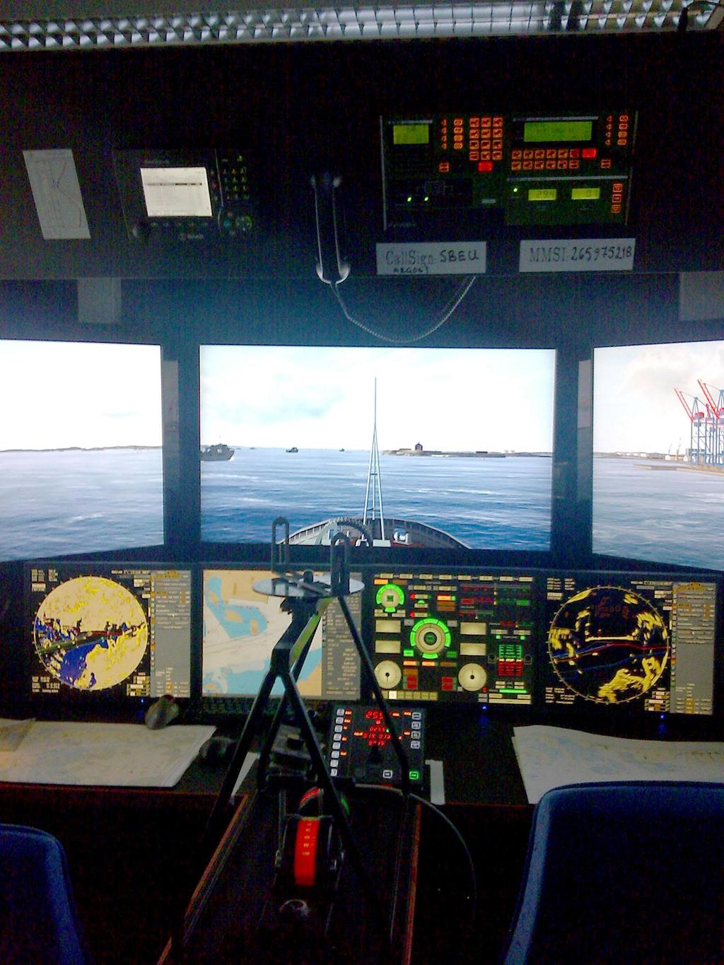
4 Is the new technology safe for navigation in coastal waters and archipelagos? As near misses not are reported we take a look at the groundings Combat boat CB 90 (mostly) Thank you Lars-Erik! ECS on board High Speed boats (ECDIS installed as ECS) and instructor education ( Common Nav Method) (High Speed Nav Method) Sw Navy: E Sandberg

5 The answer is yes? if it be done the right way
6 What is the problem? ESC (serious installed) is a good help for situational (position) awareness but what happens when ECDIS is the main system when navigating in archipelagos?
7 There are a lot of human element aspects to be resolved. Today the system design and architecture may overload and confuse, rather than help the mariner, especially in coastal and archipelago waters. Other situations with short decision times and many happenings can develop critical shortcommings. Blue water design and complexity are some of the major problems that must be solved with best practice, education and researchwork. I will show some examples in the area of gaps


8 From the small peoples* wiew User driven design? * BP
9 An example from a semiautomatic ENC update This is a potential danger action Info: cell NO4Q0719 is equal or older Yes Yes to all No No to all Cancel?
10 The Of Course Alarm Our of course alarm allways sounds

11 The autopilot handled +/- 15 degres diff and aligning in ECDIS was a unknown function as well as the systems ability to autocorrelate with actual declination 29 degrees deviation, but was + This will result a 58 degree wrong heading for the actual course
12 The actual ship have 1 st fiber optical gyro 2 st std gyros 1 st GPS-kompass 1 st magnetic compass with a TMHD sensor with connections to ECDIS Track holding DP class 3 (with shifted wires) AIS VDR INMARSAT
13 none onbord understod the architecture and which sensor who was 1st, 2 nd and no one know what source the steering display showed at least we found the documentation for the equipments (at different places)

14 ..at last the most fundamental instrument was OK and many problems are solved!
15 A closer look at the vessel and the decision support in critical situations The big peoples wiew? E-Nav Application E-Nav Application E-Nav Application INS Data sinks Application-to-application (peer-to-peer) functional connection External system(s): Position, Velocity, Timing (PNT); World Wide Radio Navigation System (WWRNS) Shipborne Rx/Tx station Data sources Other ships Physical Link (e.g. radio link) Other ships Link technology proper Shorebased enav services Shore-based e-navigation system E-Nav Application E-Nav Application E-Nav Application Other shore-based e-navigation system(s) e.g. VTS Center Source: IALA

16 Where can gaps be found and what is critical in decision making? IBS INS ECDIS ECS The system LRIT INMARSAT DSC SSAS Weather routing Navtex Pos sensors Radars Charts AIS Heading devices Loggs Sounders
17 VIDEO
18 What can be done in the shipping company and the ships? Establish the Hazards, Determine the Risk, Decide if the Risk is tolerable and Controlling the risk Identify break down factors: System errors Human errors HMI and procedure errors Bridge procedures and ISM manuals Short time decision/strategy Long time strategy Shipping company policy Training and familiarization: onboard plan/external plan Understanding the architecture on board Describe how not what!

19 Training in E-nav environment
20
21 There is still many Q for the ECDIS implementation S-mode: enough? ENC coverage: as long as not 100% the bridge must handle all methods of navigation Is there capacity of training (simulators) for the implementation of ECDIS? Is ECDIS a navigation functionality or an information management system? (Warship ECDIS a combat system?) What and when are the limits and are they identified in a safety HMI perspective? Do we take all human factors, procedures and educating factors in account? There can be a need of better course syllabus in system architecture at the academies.
22 Checklists Example of start up checklist of required features Complies? New policies, rules or regulations (company, manufacturer, transport agency).. Updated electronic charts on board for entire voyage.. Vector data (ENC) charts.. Updating system for electronic charts and charts backup (specify).. Variable display modes (North up).. Route planning ability (waypoints use, etc ).. Route monitoring/planning station.. Plot ships position by primary position sensor.. DGPS Receiver present and integration with ECDIS.. Equipment malfunction alarm.. Safety depth and/or contour setting.. Hazard proximity positioning alarm.. Off-scale or over-scale chart alarm.. Off track indication and alarm.. Loss of primary positioning information alarm.. Gyrocompass integration with ECDIS.. Magnet compass and TMHD integration ECDIS/Trackholdning.. Echo sounder integration with ECDIS.. Radar image integration with ECDIS and/or ARPA targets /AIS targets.. Speed log integration with ECDIS (STW).. Back up arrangements in case of ECDIS failure (specify).. Fall back sensors (specify).. Training bridge personnel in the use of ECDIS, including capabilities and limitations.. Power supply (both emergency and changing supplies).. Track holding system/route to auto pilot.. Is checklists the only way? Flexibility or rigidity as a result?

23
A new Modular and Open Concept for the Maritime Integrated PNT System
 A new Modular and Open Concept for the Maritime Integrated PNT System T. Noack German Aerospace Center Institute of Communications and Navigation www.dlr.de Chart 2 MTS-2012 Maritime Integrated PNT Unit
IS Shore Based Maintenance. Definition and Pricing
 IS Shore Based Maintenance Definition and Pricing Content 1 IS SBM Basic - Mandatory Annual Tests... 3 2 IS SBM Basic Com - Mandatory Annual Tests plus Communication Equipment... 4 3 IS SBM Nav - Mandatory
Technology evolution for future radiocommunication and navigation
 Technology evolution for future radiocommunication and navigation Frances Baskerville (Secretary General) Richard Doherty (Deputy Secretary General) CIRM Who we are and what we do What is CIRM? The Worldwide
COMMAND-DEQ IBS Integrated Bridge System
 COMMAND-DEQ IBS Integrated Bridge System Page : 1 / 15 NAVIGATION BRIDGE 1 Navigation System 1.1 General The total Navigation System is based on «IBS» concept (Integrated Bridge System) The navigation
TECHNICAL COMMITTEE 80: MARITIME NAVIGATION AND RADIOCOMMUNICATION EQUIPMENT AND SYSTEMS INTERNATIONAL ELECTROTECHNICAL COMMISSION
 TECHNICAL COMMITTEE 80: MARITIME NAVIGATION AND RADIOCOMMUNICATION EQUIPMENT AND SYSTEMS INTERNATIONAL ELECTROTECHNICAL COMMISSION IEC TECHNICAL COMMITTEE 80: MARITIME NAVIGATION AND RADIOCOMMUNICATION
The human touch in technology. ECDIS ECS Conning screen Ship speed info system
 The human touch in technology ECDIS ECS Conning screen Ship speed info system Alphatron ALPHACHART T ECDIS Type approved ECDIS system powered by TRANSAS The ALPHACHART T is an advanced Electronic Chart
SOLAS Compliant Navigation Systems On Naval Vessels
 SOLAS Compliant Navigation Systems On Naval Vessels D C Bradley, A Scicluna BAE Systems Australia Defence Pty Ltd, Williamstown, VIC 3016, Australia david.bradley4@baesystems.com, andrew.scicluna@baesystems.com
ROV/IMR - OFFSHORE SUPPORT VESSEL
 ROV/IMR - OFFSHORE SUPPORT VESSEL FUJIAN MAWEI DESIGN, 86.0M X 20.0M, 100T AHC CRANE, MOONPOOL, ABS +A1 (E), SPS, DPS 2, FIFI 1, ENVIRO, OIL REC Manager NORTRANS OFFSHORE II PTE LTD Class/Notation ABS
Resilient PNT: From PNT-Unit concept to first realization
 www.dlr.de Chart 1 >Resilient PNT: From PNT Unit concept to first realization> R. Ziebold > e-navigation Underway 1/3/213 Resilient PNT: From PNT-Unit concept to first realization Ralf Ziebold, Z. Dai,
INTEGRATED NAVIGATION SYSTEMS
 INTEGRATED NAVIGATION SYSTEMS Basic terms *integrated navigation system *control system *propulsion system *cargo system *digital processing unit *sensor *electronic circuits *sensor output *pulsed input
Sperry Marine Northrop Grumman
 Sperry Marine 2005 Northrop Grumman Table of Contents CHAPTER 1: CHAPTER 2: CHAPTER 3: CHAPTER 4: CHAPTER 5: CHAPTER 6: WHERE ARE YOU GOING? TRANSMITTING HEADING DEVICES DETERMINING HEADING BY SATELLITE
Transport System. Telematics. Possibility of integration of navigational information on electronic chart
 Archives of Volume 3 Transport System Issue 2 Telematics May 2010 Possibility of integration of navigational information on electronic chart H. ŚNIEGOCKI a, M. WIELIKI b a Faculty of Navigation, Gdynia
for including related operational recommendations and guidance
 GENERAL REQUIREMENTS and PERFORMANCE STANDARDS for SHIPBORNE RADIOCOMMUNICATIONS AND NAVIGATIONAL EQUIPMENT including related operational recommendations and guidance 2011 edition incorporating the 2008
DEEPSEA WORLD GENERAL CATALOG.
 DEEPSEA WORLD GENERAL CATALOG www.furuno.com Our mission Bringing together the most advanced navigational sensors and communications technology, Furuno provides the ability to create and implement optimal
Using a Pilot Laptop with the AIS pilot plug - observed errors and difficulties
 Using a Pilot Laptop with the AIS pilot plug - observed errors and difficulties 2 nd November 2008 The following pages and images detail the errors found and experience in using his Pilot Laptop by a Australian
dkart Navigator 9010
 dkart Navigator 9010 dkart Navigator - purpose dkart Navigator is an electronic navigation chart system specially designed to facilitate all the navigational tasks of mariner's day-to-day practice. Along
SIMULATORS USES FOR TRAINING OF MERCHANT VESSELS OFFICERS
 Journal of KONES Powertrain and Transport, Vol. 17, No. 3 2010 SIMULATORS USES FOR TRAINING OF MERCHANT VESSELS OFFICERS Henryk niegocki Gdynia Maritime University, Department of Navigation Jana Paw a
FURUNO DEEPSEA WORLD Class-A Universal AIS Automatic Identification System. The future today with FURUNO's electronics technology.
 R FURUNO DEEPSEA WORLD Class-A Universal AIS Automatic Identification System Model FA-100 The AIS improves the safety of navigation by assisting in the efficient navigation of ships, protection of the
Model FAR-2xx8 Model FAR-3xx0
 Model FAR-2xx8 Model FAR-3xx0 Administrerende direktør Trond Strømmen Roy Fjeldstad Area Sales Manager Advanced technologies for safe navigation The FAR-2xx8 series is a new radar series; the successor
IS SHORE-BASED MAINTENANCE
 IS SHORE-BASED MAINTENANCE Technical Data Sheet DEFINITION & SCOPE OF SERVICE Innovation for shipping IS SBM Basic Mandatory Annual Tests 1. APT for VDR (incl. Certificate of Compliance) 2. GMDSS Safety
The Pros and Cons of using ECDIS as Primary Means of Navigation
 Sections 1 2 Company introduction The PROS of Using ECDIS and ENCs 3 The CONS of Using ECDIS and ENCs 4 Why we have choose NAVTOR Company Introduction Corporate Overview. is a Ship Management Company established
ECDIS and MANTADIGITAL. PLUS
 TM MANTADIGITAL ECDIS and PLUS 2011/2012 www.ecdisplus.com Introduction What is an ECDIS? ECDIS is an acronym for Electronic Chart Display and Information System. At its simplest, an ECDIS consists of
E-NAVIGATION AND BEYOND
 E-NAVIGATION AND BEYOND The Work of IALA e-navigation Committee and Future CDR. Hideki NOGUCHI, Chair, IALA ENAV Committee e-navigation (ENAV) Committee Established in 2010 by merging R-NAV and AIS Committee
Protection Augmentation Toughness and Alternatives of GNSS. Melaha 2016 Concord Al-Salam Hotel Cairo, April 25,2016 Refaat Rashad
 Protection Augmentation Toughness and Alternatives of GNSS Melaha 2016 Concord Al-Salam Hotel Cairo, April 25,2016 Refaat Rashad Road Map of the Presentation 1- How Good are GNSS 2- How Vulnerable are
COMDTPUB P16700A NVIC September 2001 NAVIGATION AND VESSEL INSPECTION CIRCULAR NO Subj: APPROVAL OF NAVIGATION EQUIPMENT FOR SHIPS
 U.S. Department of Transportation,.f;'fiiif.'Ii United States Coast Guard Commandant, United States Coast Guard 2100 Second Street, S.W. Washington, DC 20593-0001 Staff Symbol: (G-MSE-4) Phone: (202) 267-1444
Universidad Nacional Experimental Marítima del Caribe Vicerrectorado Académico Cátedra de Idiomas Inglés VI. Ingeniería Marítima
 Universidad Nacional Experimental Marítima del Caribe Vicerrectorado Académico Cátedra de Idiomas Inglés VI. Ingeniería Marítima UNIT II. Navigational equipment found onboard ships. Speaking. 1. Can you
THE ELECTRONIC CHART DISPLAY AND INFORMATION SYSTEM (ECDIS) IN CHINA
 IN CHINA") International Hydrographic 'Review, Monaco, LXIX(2), September 1992 THE ELECTRONIC CHART DISPLAY AND INFORMATION SYSTEM (ECDIS) IN CHINA by The Research Group on ECDIS 1 Abstract This paper presents a
International Hydrographic 'Review, Monaco, LXIX(2), September 1992 THE ELECTRONIC CHART DISPLAY AND INFORMATION SYSTEM (ECDIS) IN CHINA by The Research Group on ECDIS 1 Abstract This paper presents a
ANNEX 12. RESOLUTION MSC.74(69) (adopted on 12 May 1998) ADOPTION OF NEW AND AMENDED PERFORMANCE STANDARDS
 (adopted on 12 May 1998) ADOPTION OF NEW AND AMENDED PERFORMANCE STANDARDS") RESOLUTION MSC.74(69) (adopted on 12 May 1998) ADOPTION OF NEW AND AMENDED PERFORMANCE STANDARDS THE MARITIME SAFETY COMMITTEE, RECALLING Article 28(b) of the Convention on the International Maritime Organization
RESOLUTION MSC.74(69) (adopted on 12 May 1998) ADOPTION OF NEW AND AMENDED PERFORMANCE STANDARDS THE MARITIME SAFETY COMMITTEE, RECALLING Article 28(b) of the Convention on the International Maritime Organization
UNIT 26 ELECTRONIC AIDS TO NAVIGATION
 UNIT 26 ELECTRONIC AIDS TO NAVIGATION Basic terms aid to navigation >Loran-C >Omega >Transit satellite >GPS >hyperbolic systems > satellite navigation system >fix accuracy small-screen >satnav receiver
E C D I S E LECTRONIC C HART D ISPLAY I NFORMATION S YSTEM
 e l e c t r o n i c c h a r t d i s p l a y i n f o r m a t i o n s y s t e m T R A N S A S E C D I S T R A N S A S E C D I S 3 E C D I S is a computer-based navigation information system that complies
A Survey of Mariners' Opinions on Using Electronic Charts
 s i l s Note A Survey of Mariners' Opinions on Using Electronic Charts Igor Karnicnik, M.Sc., Geodetic Institute of Slovenia, Slovenia. A new component of modern shipborne navigation equipment is the Electronic
BEATTIE PAPERS ON CIVIL MARINE ELECTRONICS
 BEATTIE PAPERS ON CIVIL MARINE ELECTRONICS SUBJECT TITLE COUNTRY DISC DATE NOTES MARINE RADAR RADAR 1 Marconi Marine Radar 1946-1996 UK 10 Jan 2002 Revised 28 Oct 2001 RADAR 2 GEC AEI Marine Radar 1946-1969
GUIDANCE FOR THE PRESENTATION AND DISPLAY OF AIS APPLICATION-SPECIFIC MESSAGES INFORMATION
 E 4 ALBERT EMBANKMENT LONDON SE1 7SR Telephone: +44 (0)20 7735 7611 Fax: +44 (0)20 7587 3210 Ref. T2-OSS/2.7.1 SN.1/Circ.290 2 June 2010 GUIDANCE FOR THE PRESENTATION AND DISPLAY OF AIS APPLICATION-SPECIFIC
COMMUNICATIONS FOR MARITIME SAFETY AND EFFICIENCY. Francis Zachariae, Secretary-General, IALA
 COMMUNICATIONS FOR MARITIME SAFETY AND EFFICIENCY Francis Zachariae, Secretary-General, IALA IALA and its Purpose Non profit, international technical association established in 1957 Two Goals aimed at
Certificate. Production Quality System MODULE D
 Certificate Production Quality System MODULE D Certificate No. P 112 (Issue 33) Telefication, operating as Body under the Directive 2014/90/EU, hereby declares that the produced products of the company:
Maritime Communications
 Maritime Communications Strategic Sectorial Spectrum Needs Conferência sobre Gestão do Espectro: Perspectivas, Desafios e Estratégias Lisboa, 20 de setembro de 2013 RSPG Work Programme 2012 and Beyond
A WINDOWS INTERFACE FOR MARITIME NAVIGATION TRAINING
 An. Şt. Univ. Ovidius Constanţa Vol. 11(1), 2003, 161 168 A WINDOWS INTERFACE FOR MARITIME NAVIGATION TRAINING Gheorghe Popescu To Professor Silviu Sburlan, at his 60 s anniversary Abstract This report
OPERATOR'S MANUAL. Electronic Chart Display and Information System (ECDIS) FEA-2107-BB FEA-2107-D FEA-2807
 FEA-2107-BB FEA-2107-D FEA-2807") OPERATOR'S MANUAL Electronic Chart Display and Information System (ECDIS) FEA-2107 FEA-2107-BB FEA-2107-D FEA-2807 MODEL FEA-2807-D Instructions for use with Autopilots: FAP-2000 PT-500A(CAT B, CAT C)
OPERATOR'S MANUAL Electronic Chart Display and Information System (ECDIS) FEA-2107 FEA-2107-BB FEA-2107-D FEA-2807 MODEL FEA-2807-D Instructions for use with Autopilots: FAP-2000 PT-500A(CAT B, CAT C)
The Impact of IT on the. Marine Navigator. Andrew Eccleston. University of Plymouth
 The Impact of IT on the Marine Navigator Andrew Eccleston University of Plymouth Marine Navigators with local connections Sir Francis Drake Sir Francis Chichester Tasksfor the Marine Navigator Navigation
CHAPTER 66 QUARTERMASTER (QM) NAVPERS E CH-67
 NAVPERS E CH-67") CHAPTER 66 QUARTERMASTER (QM) NAVPERS 18068-66E CH-67 Updated: July 2016 TABLE OF CONTENTS QUARTERMASTER (QM) SCOPE OF RATING GENERAL INFORMATION NAVIGATION ADMINISTRATOR COMMUNICATIONS ELECTRONIC SYSTEMS
CHAPTER 66 QUARTERMASTER (QM) NAVPERS 18068-66E CH-67 Updated: July 2016 TABLE OF CONTENTS QUARTERMASTER (QM) SCOPE OF RATING GENERAL INFORMATION NAVIGATION ADMINISTRATOR COMMUNICATIONS ELECTRONIC SYSTEMS
INTERNATIONAL STANDARD
 INTERNATIONAL STANDARD IEC 61174 Second edition 2001-10 Maritime navigation and radiocommunication equipment and systems Electronic chart display and information system (ECDIS) Operational and performance
Korea s Strategy for e-navigation. SMART-Navigation. Presented by. Bu Young, Kim. 28 May Ministry of Oceans and Fisheries Republic of Korea
 Korea s Strategy for e-navigation SMART-Navigation Presented by Bu Young, Kim 28 May 2014 Ministry of Oceans and Fisheries Republic of Korea 1 2 3 4 5 6 1. SMART- Navigation? SMART-Navigation Korea s
Position Cross-Checking on ECDIS in View of International Regulations Requirements and OCIMF Recommendations
 http://www.transnav.eu the International Journal on Marine Navigation and Safety of Sea Transportation Volume 10 Number 1 March 2016 DOI: 10.12716/1001.10.01.12 Position Cross-Checking on ECDIS in View
Resolution A.1106(29) Adopted on 2 December 2015 (Agenda item 10)
 Adopted on 2 December 2015 (Agenda item 10)") E ASSEMBLY 29th session Agenda item 10 A 29/Res.1106 14 December 2015 Original: ENGLISH Resolution A.1106(29) Adopted on 2 December 2015 (Agenda item 10) REVISED GUIDELINES FOR THE ONBOARD OPERATIONAL
E ASSEMBLY 29th session Agenda item 10 A 29/Res.1106 14 December 2015 Original: ENGLISH Resolution A.1106(29) Adopted on 2 December 2015 (Agenda item 10) REVISED GUIDELINES FOR THE ONBOARD OPERATIONAL
GNSS in Maritime and Education in Egypt
 GNSS in Maritime and Education in Egypt GNSS IN MARITIME PORTS SHIPS PORTS WATERWAYS GNSS maritime applications will help to improve: navigation. Ship operations. Traffic management. Seaport operations.
«INTRARADAR» Port of Corfu
 «INTRARADAR» Port of Corfu INTERREG IIIA Greece-Italy IMPETUS was the contractor of the Prefecture of Corfu for the INTRARADAR project. The project focused on the provision, installation of hardware/software
ON SOME NTPro NAUTICAL SIMULATOR IT FUNCTIONS AND POB MANEUVERS
 ON SOME NTPro NAUTICAL SIMULATOR IT FUNCTIONS AND POB MANEUVERS Sanja Bauk, D.Sc., Tatijana Dlabač, M.Sc., Radoje Džankić, Veljko Radulović University of Montenegro, Faculty of Maritime Studies, Dobrota
DEVELOPMENT OF A DEFINITION FOR MSPS AND CONSIDERATION FOR THE HARMONIZATION OF THE FORMAT AND STRUCTURE OF MSPS
 INTERNATIONAL HYDROGRAPHIC ORGANIZATION E IMO/IHO HARMONIZATION GROUP ON DATA MODELLING Agenda item 5 15 September 2017 ENGLISH ONLY DEVELOPMENT OF A DEFINITION FOR MSPS AND CONSIDERATION FOR THE HARMONIZATION
Integration of AIS functionalities
 Integration of AIS functionalities by John O. Klepsvik FARGIS 05 March 01, 2005 WORLD CLASS through people, technology and dedication WORLD CLASS through people, technology and dedication KONGSBERG March
Government Agency Perspectives & Initiatives Canadian Coast Guard Laurent Tardif, Director, Safe Shipping
 Unclassified Government Agency Perspectives & Initiatives Canadian Coast Guard Laurent Tardif, Director, Safe Shipping Mariner s Workshop January 23, 2019 1 Overview 1 Context 2 Marine Fees 3 4 5 Update
Introducing The World s First DGPS/AIS Navigation System!
 Introducing The World s First DGPS/AIS Navigation System! MX420 Navigation System: The Most Advanced DGPS/AIS Navigation Solution. MX420AIS Pioneering The Future Standards Of Navigation All navigation
GPS Jamming and its impact on maritime navigation
 GPS Jamming and its impact on maritime navigation Dr Alan Grant Research and Development - Special Interest Group 10 th May 2010 Use of GPS in the maritime sector GPS has become the normal means for maritime
Maritime Electronics Supporting Unmanned Vessels
 EU-Japan Policy Workshop Maritime Electronics Supporting Unmanned Vessels November 11 th, 2016 TAKUO KASHIWA, Ph.D Furuno Electric Co., Ltd. Agenda Positioning Technologies for Vessel s position Technologies
TECHNOLOGY DEVELOPMENT AREAS IN AAWA
 TECHNOLOGY DEVELOPMENT AREAS IN AAWA Technologies for realizing remote and autonomous ships exist. The task is to find the optimum way to combine them reliably and cost effecticely. Ship state definition
INTERNATIONAL STANDARD
 INTERNATIONAL STANDARD IEC 61924 First edition 2006-05 Maritime navigation and radiocommunication equipment and systems Integrated navigation systems Operational and performance requirements, methods of
The Role of Automatic Identification System (AIS) in Enhancing Vessel Traffic Management By Capt. Ehab Ibrahim Etman
 in Enhancing Vessel Traffic Management By Capt. Ehab Ibrahim Etman") The Role of Automatic Identification System (AIS) in Enhancing Vessel Traffic Management By Capt. Ehab Ibrahim Etman Abstract The International Maritime Organization (IMO) adopted a new requirement for
The Role of Automatic Identification System (AIS) in Enhancing Vessel Traffic Management By Capt. Ehab Ibrahim Etman Abstract The International Maritime Organization (IMO) adopted a new requirement for
E-Navigation: Opening the door to the future
 International Association of Marine Aids to Navigation and Lighthouse Authorities E-Navigation: Opening the door to the future E-Navigation Underway North America November 2018 Secretary-General Francis
ELECTRONIC NAVIGATION OPTIONAL REVIEW SUPPLEMENT October 7th, 2015
 Introduction: These are optional review questions and answers for the USPS release of the Electronic Navigation course. A thorough understanding of the facts and concepts covered is suggested for students
GUIDELINES ON THE DESIGN AND USE OF PORTABLE PILOT UNITS INTERNATIONAL MARITIME PILOTS ASSOCIATION
 GUIDELINES ON THE DESIGN AND USE OF PORTABLE PILOT UNITS INTERNATIONAL MARITIME PILOTS ASSOCIATION WITH TECHNICAL INPUT FROM Comité International Radio-Maritime (CIRM) 2 FOREWORD With the increasing use
Addendum 1.4_2. (Addendum to MX420 Operator s Manual)
") _2 (Addendum to MX420 ) September, 2007 Table of Contents About this document..1 MX575 Heading & Rate of Turn 2 MX575 as a D/GPS Compass only 2 MX575 as a D/GPS Compass with Navigation Functionality.....4
_2 (Addendum to MX420 ) September, 2007 Table of Contents About this document..1 MX575 Heading & Rate of Turn 2 MX575 as a D/GPS Compass only 2 MX575 as a D/GPS Compass with Navigation Functionality.....4
NC Models. CP390i - GPS Chart Plotters. Addendum to Owner s Manual Issue C to update to Software Version (*)
") CP390i - GPS Chart Plotters (*) NC Models to Owner s Manual Issue 16.50 C 300311 to update to Software Version 16.70 BUILT-IN CHARTS ARE NOT INSTALLED The following paragraphs/pictures are not applicable:
CP390i - GPS Chart Plotters (*) NC Models to Owner s Manual Issue 16.50 C 300311 to update to Software Version 16.70 BUILT-IN CHARTS ARE NOT INSTALLED The following paragraphs/pictures are not applicable:
Saab TransponderTech
 Saab TransponderTech R4 Combined AIS & Navigation System This page is intentionally empty Copyright The content of this document and its attachments shall remain our property. They may not without our
VALIDATION OF MODEL TRAINING COURSES. Revision of IMO model course 1.07 on Radar Navigation at Operational Level. Submitted by China SUMMARY
 E SUB-COMMITTEE ON HUMAN ELEMENT, TRAINING AND WATCHKEEPING 2nd session Agenda item 3 HTW 2/3/7 28 November 2014 Original: ENGLISH VALIDATION OF MODEL TRAINING COURSES Revision of IMO model course 1.07
IIMS TRAINING SEMINAR
 Title slide Identifying electronic equipment on today s advanced yachts? NAVIGATION EQUIPMENT non type approved 1 x Raymarine GPS ant/head 1 x Raymarine Fluxgate Compass 1 x Raymarine ST60 instruments
IMO/IALA Seminar on AIS Session No: 3 Paper No: 2
 IMO/IALA Seminar on AIS Session No: 3 Paper No: 2 1. Abstract The onboard installation of Automatic Identification System (AIS) With the implementation of AIS a substantial enhancement of maritime safety
Challenges and opportunities in the e-navigation Development. Actual projects.
 Challenges and opportunities in the e-navigation Development. Actual projects. John Erik Hagen, Regional Director Oslo, September 2018 What is e-navigation? Efficient transfer of marine information and
Brief installation guide for FA-100 Universal AIS
 Attention: All Furuno Distributors Date: April 2, 2003 SB No: FSB02-0002 Number of Pages: 5 Brief installation guide for FA-100 Universal AIS The purpose of this document is to provide and highlight important
OPERATOR'S MANUAL MARINE RADAR. FCR-21x9 FCR-21x9-BB FCR-28x9. Model.
 OPERATOR'S MANUAL MARINE RADAR Model FCR-21x9 FCR-21x9-BB FCR-28x9 www.furuno.com The paper used in this manual is elemental chlorine free. FURUNO Authorized Distributor/Dealer 9-52 Ashihara-cho, Nishinomiya,
FURUNO OVERSEAS OFFICES AND SUBSIDIARIES FURUNO CONTINENTAL SERVICE CENTERS & SPARE PARTS DEPOTS AUTHORIZED SALES/SERVICE AGENTS
 www.furuno.com FURUNO, a world's leading manufacturer of Marine Electronics, offers a comprehensive range of Navigation and Communications equipment For safe and efficient navigation, FURUNO provides a
IMO ANY OTHER BUSINESS. Progress on standards development by the IEC. Submitted by the International Electrotechnical Commission
 INTERNATIONAL MARITIME ORGANIZATION E IMO SUB-COMMITTEE ON SAFETY OF NAVIGATION 54th session Agenda item 24 NAV 54/24/1 16 April 2008 Original: ENGLISH ANY OTHER BUSINESS Progress on standards development
IALA World Wide Radio Navigation Plan
 C54/9.2/14a International Association of Marine Aids to Navigation and Lighthouse Authorities AISM Association Internationale de Signalisation Maritime IALA IALA World Wide Radio Navigation Plan Edition
Paper for Consideration by S-100WG3. Report on S-100 Sea trial of KHOA
 S-100WG3-8.1 Paper for Consideration by S-100WG3 Report on S-100 Sea trial of KHOA Submitted by: Executive Summary: Related Documents: Related Projects: Republic of Korea (KHOA) This paper reports the
THE COMPLETE GUIDE TO. Automatic Identification System
 THE COMPLETE GUIDE TO Automatic Identification System The Complete Guide to Automatic Identification Systems Leica Geosystems Inc. Copyright 2001 Leica Geosystems Inc. table this is of the contents chapter
GPSMAP 700 series owner s manual
 GPSMAP 700 series owner s manual Introduction Introduction WARNING See the Important Safety and Product Information guide in the product box for product warnings and other important information. This manual
GMDSS modernisation and e-navigation: spectrum needs
 ETSI Workshop "Future Evolution of Marine Communication", 7-8 November 2017, Sophia Antipolis, France GMDSS modernisation and e-navigation: spectrum needs Karlis Bogens BR Terrestrial Services Department
The Captains F O R U M
 The Captains F O R U M THE HUMAN-CENTRED DESIGN FORUM In December last year, the International Maritime Organization (IMO) adopted Performance Standards and approved Guidelines the combined effect of which
Real-time position tracking of traffic ships by ARPA radar and AIS in Busan Harbor, Korea
 J Kor Soc Fish Tech 44(3) 229 238 2008 DOI:103796/KSFT2008443229 Real-time position tracking of traffic ships by radar and in Busan Harbor Korea Dae-Jae LEE* Division of Marine Production System Management
PROGRESS UPDATE AND FUTURE DIRECTIONS OF THE MARINE ELECTRONIC HIGHWAY (MEH)
") PROGRESS UPDATE AND FUTURE DIRECTIONS OF THE MARINE ELECTRONIC HIGHWAY (MEH) BACKGROUND 1. The Marine Electronic Highway Demonstration Project (MEH DP) was a 4- year regional project in the Straits of
PROGRESS UPDATE AND FUTURE DIRECTIONS OF THE MARINE ELECTRONIC HIGHWAY (MEH) BACKGROUND 1. The Marine Electronic Highway Demonstration Project (MEH DP) was a 4- year regional project in the Straits of
Service instance description for the Baltic Navigational Warning Service
 Service instance description for the Baltic Navigational Warning Service 2018-01-18 Document status Authors Name Björn Andreasson Mikael Olofsson Organisation Swedish Maritime Administration Swedish Maritime
ITU matters, including Radiocommunication ITU-R Study Group matters (Agenda item 5)
") IMO NAV 59 Agenda preview Introduction The 59th session of the IMO Sub-Committee on Safety of Navigation (NAV 59) will be held from 2nd to 6th September 2013, at the IMO headquarters in London. This briefing
IMO NAV 59 Agenda preview Introduction The 59th session of the IMO Sub-Committee on Safety of Navigation (NAV 59) will be held from 2nd to 6th September 2013, at the IMO headquarters in London. This briefing
Essentials of Navigation
 Essentials of Navigation Latitudes & Longitudes, GPS, and more For Race Officers and Mark Boat Operators by Ed Bottrell eztrap Developer Glen Haven, Nova Scotia CANADA v13 email: info@bottrell.ca Website:
Date of issue: Version 01. December TRANSAS ISAILOR Functional comparison on ios and Android platforms.
 Date of issue: Version 01. December 2017 TRANSAS ISAILOR Functional comparison on ios and Android platforms. TRANSAS ISAILOR 2 1991 2017 Transas Marine Ltd. All rights reserved. The information contained
02 Issue. e-navigation News. GNSS Vulnerability. Dublin Bay Digital Diamond. e-navigation. Demonstrator Update International. e-navigation.
 CORPORATE SECURITY TEAMWORK EVENTS 02 Issue e-navigation News GNSS Vulnerability Dublin Bay Digital Diamond e-navigation Demonstrator Update International e-navigation update June 2014 www.cil.ie +353
INTERNATIONAL STANDARD
 INTERNATIONAL STANDARD IEC 61174 Edition 4.0 2015-08 colour inside Maritime navigation and radiocommunication equipment and systems Electronic chart display and information system (ECDIS) Operational and
Display of e-navigation information
 Display of e-navigation information Where do we display all this new information? Thomas Porathe Professor, Interaction design Department of Product design Norwegian University of Science and Technology
ATTACHMENT E. How to Conduct a GMDSS Inspection.
 Page 1 of 7 NOTE: This document is an excerpt from The Report and Order In the Matter of Amendment of the Commission's Rules Concerning the Inspection of Radio Installations on Large Cargo and Small Passenger
Lars Thrane A/S. September 19, LT-1000 NRU & LT-500 AHRS Installation on Grand Banks 64 Aleutian
 Lars Thrane A/S September 19, 2016 LT-1000 NRU & LT-500 AHRS Installation on Grand Banks 64 Aleutian LT-1000 NRU Key Features Navigation Reference Unit with 12 precision sensors True heading, magnetic
NOAA s National Ocean Service / Office of Coast Survey
 Coast Survey OCS 1807 2007 Maintains over 1000 nautical charts & 9 Coast Pilots Surveys over 3.4M SNM of oceans and lakes Conducts research and development in hydrography Thomas Jefferson Founder of The
Draft performance standards for shipborne "BeiDou" BDS receiver equipment
 IMO NAV 59 Summary Report Introduction The 59th session of the IMO Sub-Committee on Safety of Navigation (NAV 59) was held from 2nd to 6th September 2013, at the IMO headquarters in London. This briefing
ETSI Workshop "Future Evolution of Marine Communication Radar evolution for inland waterways navigation Mario Walterfang
 Mario Walterfang Fachstelle der WSV für Verkehrstechniken (FVT) Federal German Waterways and Shipping Administration Sophia Antipolis, France, November 7th, 2017 Overview Milestones in river radar evolution
RESOLUTION MSC.230(82) (adopted on 5 December 2006) ADOPTION OF AMENDMENTS TO THE EXISTING MANDATORY SHIP REPORTING SYSTEM "IN THE STOREBÆLT (GREAT
 (adopted on 5 December 2006) ADOPTION OF AMENDMENTS TO THE EXISTING MANDATORY SHIP REPORTING SYSTEM IN THE STOREBÆLT (GREAT") MSC 82/24/Add.2 RESOLUTION MSC.230(82) MANDATORY SHIP REPORTING SYSTEM IN THE STOREBÆLT (GREAT BELT) TRAFFIC AREA THE MARITIME SAFETY COMMITTEE, RECALLING Article 28(b) of the Convention on the International
MSC 82/24/Add.2 RESOLUTION MSC.230(82) MANDATORY SHIP REPORTING SYSTEM IN THE STOREBÆLT (GREAT BELT) TRAFFIC AREA THE MARITIME SAFETY COMMITTEE, RECALLING Article 28(b) of the Convention on the International
GMDSS RADIO INSTALLATION
 Ship s name: N.R. Survey: GMDSS RADIO INSTALLATION (Res. A.1053(27)) INITIAL (Newconstruction) PERIODICAL RENEWAL Sea areas: A1 Methods of maintenance: Duplication of (Reg. IV/12-15) A1+A2 (Reg. IV/15)
HEAVY-DUTY HIGH PERFORMANCE RASTERSCAN RADARS/ARPAS
 Complying with IMO and IEC standards for installation after 1.1.1999 HEAVY-DUTY HIGH PERFORMANCE RASTERSCAN RADARS/ARPAS Models FR/FAR-28x5 series The future today with FURUNO's electronics technology.
Capability Statement VTS Simulator MSCN
 Capability Statement VTS Simulator MSCN Version 9.3, July 2006 M A R I N P.O. Box 28 6700 AA Wageningen The Netherlands T +31 317 49 39 11 F +31 317 49 32 45 E info@marin.nl I www.marin.nl Capability Statement
BENETTI CLASSIC SUPREME 132, 2014, ITALY
 BENETTI CLASSIC SUPREME 132, 2014, ITALY price In Europe: 17 200 000 RUR 16 500 000 EUR (VAT not paid, Flag - Estonia) Technical Characteristics Length overall: 40.24 m Hull length: 40.20 m Beam overall:
SAFETY EQUIPMENT AND PREPARATION. S/V Odette USA 5619
 SAFETY EQUIPMENT AND PREPARATION S/V Odette USA 5619 Odette5619@gmail.com COMMUNICATION PREPARATION Dedicate dock time for crew to familiarize themselves with all communication equipment: VHF: Walk through
Representative Report Sub-Committee on Safety of Navigation 59th Session September 2013 London, UK
 International Association of Maritime Universities International Maritime Organization Liaison Committee Representative Report Sub-Committee on Safety of Navigation 59th Session 02-06 September 2013 London,
Generic ECDIS Training
 Generic ECDIS Training Insert Subhead Observations and Concerns 3 May 2013 16 th June 2014 Captain John Gates Head Teacher, Maritime Studies Maritime Studies Hunter TAFE, Newcastle N.S.W. Hunter TAFE Maritime
29F, Guangye East Tower, Fuhua Rd 110#, Futian, , Shenzhen, Guangdong, China
 KF-620 5.7" Color LCD DSP Fish Finder With Plastic US$328.00 5.6" LCD Fish Finder Equiped with Plastic US$368.00 KF-667 5.6" LCD Fish Finder Equiped with Bronze US$388.00 KF-868 8" Color LCD Echo Sounder
RESOLUTION MSC.229(82) (adopted on 5 December 2006) ADOPTION OF A NEW MANDATORY SHIP REPORTING SYSTEM "IN THE GALAPAGOS PARTICULARLY SENSITIVE SEA
 (adopted on 5 December 2006) ADOPTION OF A NEW MANDATORY SHIP REPORTING SYSTEM IN THE GALAPAGOS PARTICULARLY SENSITIVE SEA") MSC 82/24/Add.2 RESOLUTION MSC.229(82) IN THE GALAPAGOS PARTICULARLY SENSITIVE SEA AREA (PSSA) (GALREP) THE MARITIME SAFETY COMMITTEE, RECALLING Article 28(b) of the Convention on the International Maritime
MSC 82/24/Add.2 RESOLUTION MSC.229(82) IN THE GALAPAGOS PARTICULARLY SENSITIVE SEA AREA (PSSA) (GALREP) THE MARITIME SAFETY COMMITTEE, RECALLING Article 28(b) of the Convention on the International Maritime