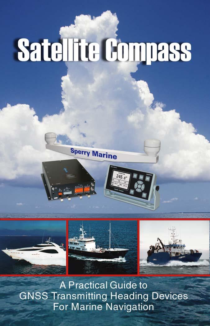
Sperry Marine Northrop Grumman
|
|
|
- Jonas Doyle
- 6 years ago
- Views:
Transcription
1

2 Sperry Marine 2005 Northrop Grumman
3
4 Table of Contents CHAPTER 1: CHAPTER 2: CHAPTER 3: CHAPTER 4: CHAPTER 5: CHAPTER 6: WHERE ARE YOU GOING? TRANSMITTING HEADING DEVICES DETERMINING HEADING BY SATELLITE CARRIAGE REQUIREMENTS PERFORMANCE STANDARDS A HYBRID SOLUTION REFERENCES ACRONYMS AND ABBREVIATIONS USEFUL LINKS

5 1 CHAPTER 1 Where Are You Going? It s often said that the most important revolution in marine navigation took place when the magnetic compass was invented. Its exact origins are forever shrouded in the mists of history, but historical references to magnetic compasses go back at least 1,000 years. With the magnetic compass, coupled with a rudimentary speed log, it became possible for mariners to leave the safety and security of the coastline and venture out onto the open ocean. For centuries, dead reckoning with magnetic compass and speed log, updated with periodic observations of celestial bodies, defined the state of the art in marine navigation. Then, in the last half of the 20 th century, the electronics revolution swept through the marine industry, bringing with it hyperbolic radionavigation aids like Decca, Omega and Loran, followed by satellite navigation systems such as Transit, GPS and Glonass, which provided real-time position fixing, and eliminating much of the need for traditional dead reckoning. But some things, it seems, never change. Determining the ship s heading and speed are still fundamental requirements in marine navigation. In fact, the proliferation of electronic systems, such as Electronic Chart 6 A P R A C T I C A L G U I D E T O
6 Display and Information Systems (ECDIS), Automatic Identification Systems (AIS), Automatic Radar Plotting Aids (ARPA) and Voyage Data Recorders (VDR), has create a need for heading reference data to function properly. Hence the appearance of a new type of navigation systems transmitting heading devices (THD). In this booklet, we will explain how satellite-based technology can satisfy this requirement for stable, accurate and reasonably priced heading data. In this booklet, we will explain how Global Navigation Satellite Systems (GNSS) can satisfy this requirement. TRANSMITTING HEADING DEVICES 7
7 2 CHAPTER 2 Transmitting Heading Devices Automatic Identification Systems (AIS), Voyage Data Recorders (VDR), Automatic Radar Plotting Aids (ARPA) and other modern ship electronic systems, which are mandated for ships under the Safety of Life at Sea (SOLAS) Convention, require accurate real-time inputs of the ship s heading to function properly. The International Maritime Organization (IMO) therefore has adopted regulations governing the new types of heading reference systems that provide these critical inputs. A Transmitting Heading Device (THD) is defined by the IMO as an electrical device that provides information about the ship s true heading. The ship s heading data must be provided in a standard format that can be used by other equipment as specified in IMO regulations. (Note that the definition calls for true, not magnetic, heading.) The THD consists of two basic parts: the sensing part (a device capable of detecting heading information) and the transmitting part (a device which receives heading information from the sensing part and converts it into the required accurate signal). The IMO documents do not specify what sort of sensor must be used to measure the ship s true heading. Thus, the THD heading sensor could be satisfied by a gyrocompass or an electronic magnetic compass, corrected for variation and deviation and capable of meeting the minimum standards for reliability and resolution. The advent of high-accuracy, real-time Global Navigation Satellite Systems (GNSS) such as 8 A P R A C T I C A L G U I D E T O
8 GPS opens a third possibility, and in the next chapter we will discuss how the satellite signals can be used to determine the ship s true heading at a fraction of the cost of a gyrocompass. ARPA Sensor Part Transmitting Part VDR AIS TRANSMITTING HEADING DEVICES 9
9 3 CHAPTER 3 Determining Heading From Satellite Signals The basic premise behind a satellite THD is simple. If you can determine the exact location of two discrete points relative to the earth, you can measure the attitude of the axis between them relative to the earth. To accomplish this you have to be able to locate the two points with a great deal of precision, especially if the baseline between them is relatively short. In addition, if one or both of the points are moving, the attitude of the axis between them is also changing, so you will need to update the positions of the two points frequently. Thus, if we align two position determining devices along the fore-and-aft line of a ship, we can extract the ship s heading and pitch. The tricky part is doing it with sufficient precision and frequency, so as to provide an accurate, stable and reliable real-time solution. Modern Global Navigation Satellite Systems (GNSS), such as GPS, Glonass and Galileo, offer the capability to measure geographic position in real time using signals from several orbiting satellites. But the raw pseudorange measurements, even when corrected with conventional differential techniques, do not yield a position with sufficient accuracy in themselves. Sophisticated real-time kinematic (RTK) techniques have therefore been developed to refine the positioning accuracy by making phase comparisons on the signal s carrier waves. The phase comparisons of the GPS signals received by the two antennas can yield a highly accurate measurement of the axis between them. A second problem with satellite-based systems is that the signals from one or more of the satellites may be 10 A P R A C T I C A L G U I D E T O
10 temporarily out of service or corrupted by influences such as multipath propagation (the tendency of signals to bounce from reflective surfaces such as a ship s superstructure), signal blockage or attenuation, interference from space-based sources (e.g., sunspots or ionospheric effects) or man-made radio-frequency interference. It is therefore necessary to provide some level of redundancy with built-in backup systems for occasions when the satellite signals are unreliable or unavailable. A third problem is update rate. While GPS satellite receivers typically provide 1 Hz (one per second) data outputs, this is insufficient for modern shipboard systems. The heading update rate requirement is 10 Hz for steering systems and 50 Hz for radar stabilization. A GNSS transmitting heading device typically uses an aerial array consisting of two or three satellite antennas connected to a single processor unit that performs the calculations necessary to determine the ship s heading.it also contains some form of backup system to enable the THD to continue operation when the satellite solution does not meet the required levels of accuracy and frequency of update. TRANSMITTING HEADING DEVICES 11
11 4 CHAPTER 4 Carriage Requirements THD carriage requirements are defined in IMO Resolution A.694 (17) and other documents (see complete reference list on page 19). New ships 300 gross tons and higher, and passenger ships irrespective of size, constructed on or after July 1, 2002, must be fitted with a properly adjusted transmitting heading device, or other means to transmit heading information for input to the ship s radar, VDR and AIS. New ships over 500 gross tons constructed since July 1, 2002, must be equipped with a gyrocompass or other means to determine and display heading by shipborne non-magnetic means and to transmit heading information for input to radar, AIS and VDR. Existing ships constructed before July 1, 2002, may continue to comply with the regulations in force prior to that date. When any systems are replaced or added to existing ships, however, they must comply with the new carriage requirements insofar as is reasonable and practical. Note that in some cases, the regulations allow for other means to be used to comply with the functional requirements of the equipment item. When other means are permitted, such means must be approved by the national administration. The SOLAS V High Speed Craft (HSC) Code establishes special additional carriage requirements. It states that new passenger craft constructed since July 1, 2002, certified to carry 100 passengers or less, 12 A P R A C T I C A L G U I D E T O
12 must be fitted with a properly adjusted transmitting heading device suitable for the speed and motion characteristics and area of operation of the craft, capable of transmitting a true heading reference to other equipment. Larger passenger vessels (over 100 passengers) must be fitted with a gyrocompass. From January 1, 2003, existing passenger ships certified to carry 100 passengers or less must be fitted with an instrument providing a heading reference of accuracy superior to that provided by a magnetic compass. IMO CARRIAGE REQUIREMENTS Ship Type New ships of 500 grt and upwards constructed after July 1, 2002 New ships of 300 grt and upwards and passenger ships irrespective of size constructed after July 1, 2002 Existing ships constructed prior to July 1, 2002 Requirement Gyrocompass or other means to determine and display heading by nonmagnetic means and transmit to designated devices Properly adjusted transmitting heading device (THD) or other means to transmit heading to designated devices Comply with regulations in force prior to July 1, When systems are upgraded or replaced, must comply with new regulations HIGH SPEED CRAFT CODE Ship Type New passenger ships carrying 100 passengers or less, constructed after July 1, 2002 Passenger vessels carrying more than 100 passengers Requirement Properly adjusted transmitting heading device (THD) capable of transmitting true heading reference to other equipment Gyrocompass TRANSMITTING HEADING DEVICES 13
13 5 CHAPTER 5 Performance Standards Detailed performance standards for marine GNSS transmitting heading devices are contained in IMO Resolution MSC.116 (73) and ISO International Standard The following is a brief summary of relevant provisions. Users should refer to the source documents (see References, page 17) for complete information. The THD must be capable of continuous operation under conditions of vibration, humidity and temperature spelled out in detail in ISO All displays, with the exception of the sensor, and all outputs of heading must indicate true heading. The THD must have means to align the sensing direction to the ship s fore and aft line. The THD must be able to maintain the heading accuracy within ±1.5 for at least 60 seconds if the satellite signal is interrupted. Settling time must be less than 10 minutes under static conditions. The THD must output a new heading at least once every 50 ms. At least one digital serial output must comply with IEC The THD must be equipped with an alarm to indicate THD malfunction, failure of power supply and continuous GNSS signal interruption over 60 seconds at least. The transmission error, including the resolution error, must be less than ±2. The static error (settle point error) at any heading must be within 1.0, 95%. 14 A P R A C T I C A L G U I D E T O
14 The dynamic error must be within 1.5, 95%. The follow-up error for different rates of turn must be: Less than ±0.5 up to a rate of 10 per second Less than ±1.5 up to a rate of between 10 and 20 per second DEFINITIONS Transmission and resolution error. Error which is caused by the method used to transmit the original information to a receiving device. This error is caused by the method used inside the THD and at its output to code the information. Static Error. Error which is caused by any reason and which stays unchanged in value during the operation of the system. This error should be measured under static conditions. Dynamic Error. Error which is caused by dynamic influences acting on the system, such as vibration, roll, pitch or linear acceleration. This error may have an amplitude and usually a frequency related to the environmental influences and the parameters of the system itself. Follow-up Error. Error which is caused by the delay between the existence of a value to be sensed and the availability of the corresponding signal or data steam at the output of the system for instance, the difference between the real heading of turning vessel and the available information at the output of the system. The follow-up error disappears when the system is static. TRANSMITTING HEADING DEVICES 15
15 6 CHAPTER 6 A Hybrid Solution The Sperry Marine NAVISTAR system has been designed to meet the IMO requirement for transmitting heading devices on new ships gross tons, and as a viable low-cost alternative to spinning-mass and fiber-optic gyrocompasses for workboats, fishing boats, pleasure yachts, naval patrol boats and other smaller vessels not required to carry a gyrocompass. NAVISTAR incorporates a unique hybrid design, using advanced attitude algorithms to process phase data from two GPS carrier frequencies, together with data from three gyro rate sensors and three accelerometers to provide a stable and reliable geographic-north oriented heading reference. In addition to true heading, the system also outputs rate of turn, speed over ground and GPS position in standard maritime message formats. NAVISTAR provides a very high dynamic accuracy and rapid start-up times. The very high update rate makes the NAVISTAR an ideal heading reference for modern adaptive autopilots. The system provides eight selectable heading output ports. All output data is provided in industry-standard IEC formats suitable for integration into repeaters, radars, autopilots, chart plotters, scanning sonars, AIS, VDR and steerable antenna arrays. The system also contains a three-axis magnetic field sensor for redundancy and backup. The magnetic field sensor is automatically corrected for deviation and variation to provide true heading. An internal compass monitor constantly compares the GPS solution against the magnetic heading sensor. In case of degradation or loss of GPS data, an audible alarm sounds, and the system automati- 16 A P R A C T I C A L G U I D E T O

16 cally defaults to the internal magnetic compass for uninterrupted navigation. The NAVISTAR system consists of three primary components: the dual GPS antenna array, the processor unit and the control/display unit with large, high-resolution LCD screen, plus connecting cables. The system runs on VDC power supply and is designed for easy installation on new or existing vessels. It has no moving parts and is virtually maintenance free. The three rate gyros and accelerometers provide angular rate and acceleration data in three planes with a very high update rate of 100 times per second. They can supply heading for up to 3 minutes with no reset from the GPS or Heading Selector & Compass Monitor Head-Up Compass Card TRANSMITTING HEADING DEVICES 17
17 magnetic sensor. The two GPS receivers provide heading updates approximately once per second. The three-axis magnetic sensor, compensated for deviation and variation, supplies low-frequency heading for comparison and backup. The computer uses advanced attitude algorithms to process the data from all sources and produce outputs of heading, roll, pitch, speed and course over ground, latitude and longitude and a GPS time reference. The NAVISTAR system computes attitude from the rate gyros and accelerometers, with resets typically every second from the GPS receivers. 18 A P R A C T I C A L G U I D E T O
18 REFERENCES The following source documents provide detailed information on carriage requirements and performance standards for transmitting heading devices. IMO Resolution A.694 (17) Recommendations on General Requirements for Shipborne Radio Equipment Forming Part of the Global Maritime Distress and Safety System (GMDSS) and for Electronic Navigational Aids. MSC.116 (73) Recommendations on Performance Standards for Marine Transmitting Heading Devices (THDs). ISO international Standard ISO/DIS Ships and Marine Technology Transmitting Heading Devices (THDs) Part 3: GNSS Principles. IEC Maritime Navigation and Radiocommunication Equipment and Systems General Requirements Methods of Testing and Required Test Results. IEC Maritime Navigation and Radiocommunication Equipment and Systems Digital Interfaces SOLAS V Regulation 19 Carriage Requirements for Shipborne Navigational Systems and Equipment. SOLAS V Regulation 18 Approvals, Surveys and Performance Standards of Navigational Systems and Equipment and Voyage Data Recorders. SOLAS V Annex 11 Navigational Equipment New Ships SOLAS V Annex 12 Navigational Equipment Existing Ships SOLAS V Annex 19 High Speed Craft Code, Chapter 13 Shipborne Navigational Systems and Equipment and Voyage Data Recorder. IMO Resolution A.813 (19) General Requirements for Electromagnetic Compatibility (EMC) for All Electrical and Electronic Ship s Equipment. GNSS TRANSMITTING HEADING DEVICES 19
19 ABBREVIATIONS AND ACRONYMS AIS... Automatic Identification System ARPA... Automatic Radar Plotting Aid COG... Course over Ground DGPS... Differential GPS ECDIS... Electronic Chart Display and Information System EPA... Electronic Plotting Aid GNSS... Global Navigation Satellite System GPS... Global Positioning System IEC... International Electrotechnical Commission IMO... International Maritime Organization ISO... International Standards Organization ROT... Rate of Turn RTCM... Radio Technical Commission for Maritime Services SOG... Speed over Ground SOLAS V... Safety of Life at Sea Convention, Chapter V THD... Transmitting Heading Device VDR... Voyage Data Recorder 20 A P R A C T I C A L G U I D E T O
20 USEFUL LINKS Sperry Marine U.S. Coast Guard Navigation Center International Maritime Organization International Electrotechnical Commission Marine and Coastguard Agency Seamanship International GNSS TRANSMITTING HEADING DEVICES 21
21 Sperry Marine Northrop Grumman BR0111 XM 12/03/05 Printed In The U.S.A.
RESOLUTION MSC.116(73) (adopted on 1 December 2000) PERFORMANCE STANDARDS FOR MARINE TRANSMITTING HEADING DEVICES (THDs)
 (adopted on 1 December 2000) PERFORMANCE STANDARDS FOR MARINE TRANSMITTING HEADING DEVICES (THDs)") MSC 73/21/Add.3 RESOLUTION MSC.116(73) THE MARITIME SAFETY COMMITTEE, RECALLING Article (28(b) of the Convention on the International Maritime Organization concerning the functions of the Committee, RECALLING
MSC 73/21/Add.3 RESOLUTION MSC.116(73) THE MARITIME SAFETY COMMITTEE, RECALLING Article (28(b) of the Convention on the International Maritime Organization concerning the functions of the Committee, RECALLING
RESOLUTION MSC.112(73) (adopted on 1 December 2000) ADOPTION OF THE REVISED PERFORMANCE STANDARDS FOR SHIPBORNE GLOBAL POSITIONING SYSTEM (GPS)
 (adopted on 1 December 2000) ADOPTION OF THE REVISED PERFORMANCE STANDARDS FOR SHIPBORNE GLOBAL POSITIONING SYSTEM (GPS)") MSC 73/21/Add.3 RESOLUTION MSC.112(73) FOR SHIPBORNE GLOBAL POSITIONING SYSTEM THE MARITIME SAFETY COMMITTEE, RECALLING Article (28(b) of the Convention on the International Maritime Organization concerning
MSC 73/21/Add.3 RESOLUTION MSC.112(73) FOR SHIPBORNE GLOBAL POSITIONING SYSTEM THE MARITIME SAFETY COMMITTEE, RECALLING Article (28(b) of the Convention on the International Maritime Organization concerning
TECHNICAL COMMITTEE 80: MARITIME NAVIGATION AND RADIOCOMMUNICATION EQUIPMENT AND SYSTEMS INTERNATIONAL ELECTROTECHNICAL COMMISSION
 TECHNICAL COMMITTEE 80: MARITIME NAVIGATION AND RADIOCOMMUNICATION EQUIPMENT AND SYSTEMS INTERNATIONAL ELECTROTECHNICAL COMMISSION IEC TECHNICAL COMMITTEE 80: MARITIME NAVIGATION AND RADIOCOMMUNICATION
ANNEX 12. RESOLUTION MSC.74(69) (adopted on 12 May 1998) ADOPTION OF NEW AND AMENDED PERFORMANCE STANDARDS
 (adopted on 12 May 1998) ADOPTION OF NEW AND AMENDED PERFORMANCE STANDARDS") RESOLUTION MSC.74(69) (adopted on 12 May 1998) ADOPTION OF NEW AND AMENDED PERFORMANCE STANDARDS THE MARITIME SAFETY COMMITTEE, RECALLING Article 28(b) of the Convention on the International Maritime Organization
RESOLUTION MSC.74(69) (adopted on 12 May 1998) ADOPTION OF NEW AND AMENDED PERFORMANCE STANDARDS THE MARITIME SAFETY COMMITTEE, RECALLING Article 28(b) of the Convention on the International Maritime Organization
RESOLUTION MSC.401(95) (Adopted on 8 June 2015) PERFORMANCE STANDARDS FOR MULTI-SYSTEM SHIPBORNE RADIONAVIGATION RECEIVERS
 (Adopted on 8 June 2015) PERFORMANCE STANDARDS FOR MULTI-SYSTEM SHIPBORNE RADIONAVIGATION RECEIVERS") ANNEX 17 MSC 95/22/Add.2 Annex 17, page 1 THE MARITIME SAFETY COMMITTEE, RECALLING Article 28(b) of the Convention on the International Maritime Organization concerning the functions of the Committee,
ANNEX 17 MSC 95/22/Add.2 Annex 17, page 1 THE MARITIME SAFETY COMMITTEE, RECALLING Article 28(b) of the Convention on the International Maritime Organization concerning the functions of the Committee,
GUIDELINES ON ANNUAL TESTING OF THE AUTOMATIC IDENTIFICATION SYSTEM (AIS)
") INTERNATIONAL MARITIME ORGANIZATION 4 ALBERT EMBANKMENT LONDON SE1 7SR Telephone: 020 7735 7611 Fax: 020 7587 3210 IMO E Ref. T1/10 MSC.1/Circ.1252 22 October 2007 GUIDELINES ON ANNUAL TESTING OF THE AUTOMATIC
INTERNATIONAL MARITIME ORGANIZATION 4 ALBERT EMBANKMENT LONDON SE1 7SR Telephone: 020 7735 7611 Fax: 020 7587 3210 IMO E Ref. T1/10 MSC.1/Circ.1252 22 October 2007 GUIDELINES ON ANNUAL TESTING OF THE AUTOMATIC
RESOLUTION MSC.233(82) (adopted on 5 December 2006) ADOPTION OF THE PERFORMANCE STANDARDS FOR SHIPBORNE GALILEO RECEIVER EQUIPMENT
 (adopted on 5 December 2006) ADOPTION OF THE PERFORMANCE STANDARDS FOR SHIPBORNE GALILEO RECEIVER EQUIPMENT") MSC 82/24/Add.2 RESOLUTION MSC.233(82) THE MARITIME SAFETY COMMITTEE, RECALLING Article 28(b) of the Convention on the International Maritime Organization concerning the functions of the Committee, RECALLING
MSC 82/24/Add.2 RESOLUTION MSC.233(82) THE MARITIME SAFETY COMMITTEE, RECALLING Article 28(b) of the Convention on the International Maritime Organization concerning the functions of the Committee, RECALLING
for including related operational recommendations and guidance
 GENERAL REQUIREMENTS and PERFORMANCE STANDARDS for SHIPBORNE RADIOCOMMUNICATIONS AND NAVIGATIONAL EQUIPMENT including related operational recommendations and guidance 2011 edition incorporating the 2008
FURUNO DEEPSEA WORLD Class-A Universal AIS Automatic Identification System. The future today with FURUNO's electronics technology.
 R FURUNO DEEPSEA WORLD Class-A Universal AIS Automatic Identification System Model FA-100 The AIS improves the safety of navigation by assisting in the efficient navigation of ships, protection of the
COMDTPUB P16700A NVIC September 2001 NAVIGATION AND VESSEL INSPECTION CIRCULAR NO Subj: APPROVAL OF NAVIGATION EQUIPMENT FOR SHIPS
 U.S. Department of Transportation,.f;'fiiif.'Ii United States Coast Guard Commandant, United States Coast Guard 2100 Second Street, S.W. Washington, DC 20593-0001 Staff Symbol: (G-MSE-4) Phone: (202) 267-1444
INTERNATIONAL STANDARD
 INTERNATIONAL STANDARD IEC 61174 Second edition 2001-10 Maritime navigation and radiocommunication equipment and systems Electronic chart display and information system (ECDIS) Operational and performance
NAVIGAT Fiber-Optic Gyrocompass and Attitude Reference System. Sperry Marine. The Dynamic Solution for a Demanding Challenge
 NAVIGAT 2100 Fiber-Optic Gyrocompass and Attitude Reference System Sperry Marine The Dynamic Solution for a Demanding Challenge NAVIGAT 2100 Fiber-Optic Gyrocompass and Attitude Fiber-Optic Sensor Unit
Addendum 1.4_2. (Addendum to MX420 Operator s Manual)
") _2 (Addendum to MX420 ) September, 2007 Table of Contents About this document..1 MX575 Heading & Rate of Turn 2 MX575 as a D/GPS Compass only 2 MX575 as a D/GPS Compass with Navigation Functionality.....4
_2 (Addendum to MX420 ) September, 2007 Table of Contents About this document..1 MX575 Heading & Rate of Turn 2 MX575 as a D/GPS Compass only 2 MX575 as a D/GPS Compass with Navigation Functionality.....4
GUIDELINES ON THE DESIGN AND USE OF PORTABLE PILOT UNITS INTERNATIONAL MARITIME PILOTS ASSOCIATION
 GUIDELINES ON THE DESIGN AND USE OF PORTABLE PILOT UNITS INTERNATIONAL MARITIME PILOTS ASSOCIATION WITH TECHNICAL INPUT FROM Comité International Radio-Maritime (CIRM) 2 FOREWORD With the increasing use
Ships and marine technology Marine gyro-compasses
 Provläsningsexemplar / Preview INTERNATIONAL STANDARD ISO 8728 Third edition 2014-08-01 Ships and marine technology Marine gyro-compasses Navires et technologie maritime Compas gyroscopiques à usage marin
SOLAS Compliant Navigation Systems On Naval Vessels
 SOLAS Compliant Navigation Systems On Naval Vessels D C Bradley, A Scicluna BAE Systems Australia Defence Pty Ltd, Williamstown, VIC 3016, Australia david.bradley4@baesystems.com, andrew.scicluna@baesystems.com
INTERNATIONAL STANDARD
 INTERNATIONAL STANDARD IEC 60936-2 First edition 1998-10 Maritime navigation and radiocommunication equipment and systems Radar Part 2: Shipborne radar for high-speed craft (HSC) Methods of testing and
RECOMMENDATION ITU-R M *
 Rec. ITU-R M.823-3 1 RECOMMENDATION ITU-R M.823-3 * Technical characteristics of differential transmissions for global navigation satellite systems from maritime radio beacons in the frequency band 283.5-315
Guideline No.N-01 (201510) N-01 Marine Radar. Issued date: 20 th October, China Classification Society
 N-01 Marine Radar. Issued date: 20 th October, China Classification Society") Guideline No.N-01 (201510) N-01 Marine Radar Issued date: 20 th October, 2015 China Classification Society Foreword This Guideline is a part of CCS Rules, which contains technical requirements, inspection
Guideline No.N-01 (201510) N-01 Marine Radar Issued date: 20 th October, 2015 China Classification Society Foreword This Guideline is a part of CCS Rules, which contains technical requirements, inspection
INTERNATIONAL STANDARD
 INTERNATIONAL STANDARD IEC 60872-2 First edition 1999-01 Maritime navigation and radiocommunication equipment and systems Radar plotting aids Part 2: Automatic tracking aids (ATA) Methods of testing and
UNIT 26 ELECTRONIC AIDS TO NAVIGATION
 UNIT 26 ELECTRONIC AIDS TO NAVIGATION Basic terms aid to navigation >Loran-C >Omega >Transit satellite >GPS >hyperbolic systems > satellite navigation system >fix accuracy small-screen >satnav receiver
Frank Heymann 1.
 Plausibility analysis of navigation related AIS parameter based on time series Frank Heymann 1 1 Deutsches Zentrum für Luft und Raumfahrt ev, Neustrelitz, Germany email: frank.heymann@dlr.de In this paper
ATTACHMENT E. How to Conduct a GMDSS Inspection.
 Page 1 of 7 NOTE: This document is an excerpt from The Report and Order In the Matter of Amendment of the Commission's Rules Concerning the Inspection of Radio Installations on Large Cargo and Small Passenger
INTERNATIONAL STANDARD
 INTERNATIONAL STANDARD IEC 61924 First edition 2006-05 Maritime navigation and radiocommunication equipment and systems Integrated navigation systems Operational and performance requirements, methods of
Dynamic Sensor. JLR-31 GPS compass RMS. the JLR-31 sets a new standard of GPS compass, with its renowned high performance and new features
 GPS compass Dynamic Sensor 3D RMS the JLR-31 sets a new standard of GPS compass, with its renowned high performance and new features 5.7-inch high visibility display Roll, pitch, rate of turn and heave
INTERNATIONAL STANDARD
 INTERNATIONAL STANDARD IEC 61108-1 Second edition 2003-07 Maritime navigation and radiocommunication equipment and systems Global navigation satellite systems (GNSS) Part 1: Global positioning system (GPS)
INTERNATIONAL STANDARD
 INTERNATIONAL STANDARD IEC 61993-2 First edition 2001-12 Maritime navigation and radiocommunication equipment and systems Automatic identification systems (AIS) Part 2: Class A shipborne equipment of the
RESOLUTION MSC.363(92) (Adopted on 14 June 2013) PERFORMANCE STANDARDS FOR ELECTRONIC INCLINOMETERS
 (Adopted on 14 June 2013) PERFORMANCE STANDARDS FOR ELECTRONIC INCLINOMETERS") ANNEX 23 MSC 92/26/Add.1 Annex 23, page 1 THE MARITIME SAFETY COMMITTEE, RECALLING Article 28(b) of the Convention on the International Maritime Organization concerning the functions of the Committee,
ANNEX 23 MSC 92/26/Add.1 Annex 23, page 1 THE MARITIME SAFETY COMMITTEE, RECALLING Article 28(b) of the Convention on the International Maritime Organization concerning the functions of the Committee,
Resolution A.1106(29) Adopted on 2 December 2015 (Agenda item 10)
 Adopted on 2 December 2015 (Agenda item 10)") E ASSEMBLY 29th session Agenda item 10 A 29/Res.1106 14 December 2015 Original: ENGLISH Resolution A.1106(29) Adopted on 2 December 2015 (Agenda item 10) REVISED GUIDELINES FOR THE ONBOARD OPERATIONAL
E ASSEMBLY 29th session Agenda item 10 A 29/Res.1106 14 December 2015 Original: ENGLISH Resolution A.1106(29) Adopted on 2 December 2015 (Agenda item 10) REVISED GUIDELINES FOR THE ONBOARD OPERATIONAL
RESOLUTION A.820(19) adopted on 23 November 1995 PERFORMANCE STANDARDS FOR NAVIGATIONAL RADAR EQUIPMENT FOR HIGH-SPEED CRAFT
 adopted on 23 November 1995 PERFORMANCE STANDARDS FOR NAVIGATIONAL RADAR EQUIPMENT FOR HIGH-SPEED CRAFT") INTERNATIONAL MARITIME ORGANIZATION A 19/Res. 820 15 December 1995 Original: ENGLISH ASSEMBLY 19th session Agenda item 10 NOT TO BE REMOVED \ FROM THE IMO LIBRARY RESOLUTION A.820(19) adopted on 23 November
INTERNATIONAL MARITIME ORGANIZATION A 19/Res. 820 15 December 1995 Original: ENGLISH ASSEMBLY 19th session Agenda item 10 NOT TO BE REMOVED \ FROM THE IMO LIBRARY RESOLUTION A.820(19) adopted on 23 November
dkart Navigator 9010
 dkart Navigator 9010 dkart Navigator - purpose dkart Navigator is an electronic navigation chart system specially designed to facilitate all the navigational tasks of mariner's day-to-day practice. Along
A new Modular and Open Concept for the Maritime Integrated PNT System
 A new Modular and Open Concept for the Maritime Integrated PNT System T. Noack German Aerospace Center Institute of Communications and Navigation www.dlr.de Chart 2 MTS-2012 Maritime Integrated PNT Unit
Model FAR-2xx8 Model FAR-3xx0
 Model FAR-2xx8 Model FAR-3xx0 Administrerende direktør Trond Strømmen Roy Fjeldstad Area Sales Manager Advanced technologies for safe navigation The FAR-2xx8 series is a new radar series; the successor
PHINS, An All-In-One Sensor for DP Applications
 DYNAMIC POSITIONING CONFERENCE September 28-30, 2004 Sensors PHINS, An All-In-One Sensor for DP Applications Yves PATUREL IXSea (Marly le Roi, France) ABSTRACT DP positioning sensors are mainly GPS receivers
08/10/2013. Marine Positioning Systems Surface and Underwater Positioning. egm502 seafloor mapping
 egm502 seafloor mapping lecture 8 navigation and positioning Marine Positioning Systems Surface and Underwater Positioning All observations at sea need to be related to a geographical position. To precisely
Fisheries and Marine Resources (Automatic Identification System) Regulations
 Regulations") Fisheries and Marine Resources (Automatic Identification System) Regulations 2016 GN No. 116 of 2016 Government Gazette of Mauritius No. 47of 28 May 2016 THE FISHERIES AND MARINE RESOURCES ACT Regulations
Fisheries and Marine Resources (Automatic Identification System) Regulations 2016 GN No. 116 of 2016 Government Gazette of Mauritius No. 47of 28 May 2016 THE FISHERIES AND MARINE RESOURCES ACT Regulations
Appendix: References and glossary
 Appendix: References and glossary Facts about electronic charts and carriage requirements 2nd edition 2007 V/1 CONTENTS OF SECTION 5 Appendix: References and glossary References...................................................
This is a preview - click here to buy the full publication INTERNATIONAL. Edition 1:1999 consolidated with amendment 1:2002
 INTERNATIONAL IEC STANDARD 60936-1 Edition 1.1 2002-08 Edition 1:1999 consolidated with amendment 1:2002 Maritime navigation and radiocommunication equipment and systems Radar Part 1: Shipborne radar Performance
Meridian Gyrocompasses
 TELEDYNE TSS WORLD LEADERS IN MARINE INSTRUMENTATION Meridian Gyrocompasses MARINE NAVIGATION SYSTEMS Highly accurate performance with low cost of ownership. The Meridian gyrocompass product range is suitable
360 compass card and digital display Performance Settle point error 0.25 secant latitude 0.10 secant latitude
 Meridian GYROCOMPASSES TECHNICAL SPECIFICATIONS Display Standard 360 compass card and digital display Surveyor Performance Settle point error 0.25 secant latitude 0.10 secant latitude Settle point repeatability
THE COMPLETE GUIDE TO. Automatic Identification System
 THE COMPLETE GUIDE TO Automatic Identification System The Complete Guide to Automatic Identification Systems Leica Geosystems Inc. Copyright 2001 Leica Geosystems Inc. table this is of the contents chapter
NMEA2000- Par PGN. Mandatory Request, Command, or Acknowledge Group Function Receive/Transmit PGN's
 PGN Number Category Notes - Datum Local geodetic datum and datum offsets from a reference datum. T The Request / Command / Acknowledge Group type of 126208 - NMEA - Request function is defined by first
IMO WORLD-WIDE RADIONAVIGATION SYSTEM (WWRNS) GALILEO receiver performance standards. Submitted by the European Commission
 GALILEO receiver performance standards. Submitted by the European Commission") INTERNATIONAL MARITIME ORGANIZATION E IMO SUB-COMMITTEE ON SAFETY OF NAVIGATION 50th session Agenda item 13 2 April 2004 Original: ENGLISH WORLD-WIDE RADIONAVIGATION SYSTEM (WWRNS) GALILEO receiver performance
INTERNATIONAL MARITIME ORGANIZATION E IMO SUB-COMMITTEE ON SAFETY OF NAVIGATION 50th session Agenda item 13 2 April 2004 Original: ENGLISH WORLD-WIDE RADIONAVIGATION SYSTEM (WWRNS) GALILEO receiver performance
Is the new technology safe for navigation in coastal waters and archipelagos?
 3.35.20 Is the new technology safe for navigation in coastal waters and archipelagos? As near misses not are reported we take a look at the groundings Combat boat CB 90 (mostly) Thank you Lars-Erik! ECS
INTERNATIONAL STANDARD
 INTERNATIONAL STANDARD IEC 62287-1 First edition 2006-03 Maritime navigation and radiocommunication equipment and systems Class B shipborne equipment of the automatic identification system (AIS) Part 1:
COMMAND-DEQ IBS Integrated Bridge System
 COMMAND-DEQ IBS Integrated Bridge System Page : 1 / 15 NAVIGATION BRIDGE 1 Navigation System 1.1 General The total Navigation System is based on «IBS» concept (Integrated Bridge System) The navigation
RESOLUTION MSC.114(73) (adopted on 1 December 2000) ADOPTION OF THE REVISED PERFORMANCE STANDARDS FOR SHIPBORNE DGPS AND DGLONASS MARITIME RADIO
 (adopted on 1 December 2000) ADOPTION OF THE REVISED PERFORMANCE STANDARDS FOR SHIPBORNE DGPS AND DGLONASS MARITIME RADIO") MSC 73/21/Add.3 RESOLUTION MSC.114(73) FOR SHIPBORNE DGPS AND DGLONASS MARITIME RADIO BEACON RECEIVER EQUIPMENT THE MARITIME SAFETY COMMITTEE, RECALLING Article (28(b) of the Convention on the International
MSC 73/21/Add.3 RESOLUTION MSC.114(73) FOR SHIPBORNE DGPS AND DGLONASS MARITIME RADIO BEACON RECEIVER EQUIPMENT THE MARITIME SAFETY COMMITTEE, RECALLING Article (28(b) of the Convention on the International
The FA-50 offers accurate information for collision avoidance
 The FA-50 offers accurate information for collision avoidance with GPS antenna GPA-017S FURUNO s FA-50 class-b AIS transponder receives navigation data from AIS-equipped vessels nearby that can be utilized
IMO ANY OTHER BUSINESS. Progress on standards development by the IEC. Submitted by the International Electrotechnical Commission
 INTERNATIONAL MARITIME ORGANIZATION E IMO SUB-COMMITTEE ON SAFETY OF NAVIGATION 54th session Agenda item 24 NAV 54/24/1 16 April 2008 Original: ENGLISH ANY OTHER BUSINESS Progress on standards development
The Impact of IT on the. Marine Navigator. Andrew Eccleston. University of Plymouth
 The Impact of IT on the Marine Navigator Andrew Eccleston University of Plymouth Marine Navigators with local connections Sir Francis Drake Sir Francis Chichester Tasksfor the Marine Navigator Navigation
This circular summarizes the various important aspects of the LRIT system with a view to enabling companies to ensure compliance in a timely manner.
 Luxembourg, 29/10/2008 CIRCULAR CAM 02/2008 N/Réf. : AH/63353 Subject : Long-Range Identification and Tracking of Ships (LRIT) To : All ship owners, ship operators and designated persons of Luxembourg
This document is a preview generated by EVS
 INTERNATIONAL STANDARD IEC 61108-3 Edition 1.0 2010-05 colour inside Maritime navigation and radiocommunication equipment and systems Global navigation satellite systems (GNSS) Part 3: Galileo receiver
AIS Training. AIS Technology in Digital Yacht Products Explained. Digital Yacht Ltd TEL
 AIS Training AIS Technology in Digital Yacht Products Explained Digital Yacht Ltd www.digitalyacht.co.uk TEL + 44 1179 554474 What is AIS? The Automatic Identification System (AIS) is the biggest advance
INTERNATIONAL STANDARD
 INTERNATIONAL STANDARD IEC 62065 First edition 2002-03 Maritime navigation and radiocommunication equipment and systems Track control systems Operational and performance requirements, methods of testing
ANNUAL OF NAVIGATION 19/2012/part 1
 ANNUAL OF NAVIGATION 19/2012/part 1 PAWEŁ BANYŚ, THORALF NOACK, STEFAN GEWIES German Aerospace Center (DLR), Institute of Communications and Navigation (IKN) ASSESSMENT OF AIS VESSEL POSITION REPORT UNDER
Universal Shipborne Automatic Identification System (AIS) Transponder
 Transponder") Universal Shipborne Automatic Identification System (AIS) Transponder What is an AIS? Picture a shipboard radar display, with overlaid electronic chart data, that includes a mark for every significant
Universal Shipborne Automatic Identification System (AIS) Transponder What is an AIS? Picture a shipboard radar display, with overlaid electronic chart data, that includes a mark for every significant
FieldGenius Technical Notes GPS Terminology
 FieldGenius Technical Notes GPS Terminology Almanac A set of Keplerian orbital parameters which allow the satellite positions to be predicted into the future. Ambiguity An integer value of the number of
GNSS in Maritime and Education in Egypt
 GNSS in Maritime and Education in Egypt GNSS IN MARITIME PORTS SHIPS PORTS WATERWAYS GNSS maritime applications will help to improve: navigation. Ship operations. Traffic management. Seaport operations.
Receiver Technology CRESCENT OEM WHITE PAPER AMY DEWIS JENNIFER COLPITTS
 CRESCENT OEM WHITE PAPER AMY DEWIS JENNIFER COLPITTS With offices in Kansas City, Hiawatha, Calgary and Scottsdale, Hemisphere GPS is a global leader in designing and manufacturing innovative, costeffective,
INTERNATIONAL STANDARD
 INTERNATIONAL STANDARD IEC 61097-2 Second edition 2002-09 Global maritime distress and safety system (GMDSS) Part 2: COSPAS-SARSAT EPIRB Satellite emergency position indicating radio beacon operating on
Introducing The World s First DGPS/AIS Navigation System!
 Introducing The World s First DGPS/AIS Navigation System! MX420 Navigation System: The Most Advanced DGPS/AIS Navigation Solution. MX420AIS Pioneering The Future Standards Of Navigation All navigation
RESOLUTION MSC.278(85) (adopted on 1 December 2008) ADOPTION OF THE NEW MANDATORY SHIP REPORTING SYSTEM "OFF THE COAST OF PORTUGAL - COPREP"
 (adopted on 1 December 2008) ADOPTION OF THE NEW MANDATORY SHIP REPORTING SYSTEM OFF THE COAST OF PORTUGAL - COPREP") MSC 85/26/Add.1 RESOLUTION MSC.278(85) SYSTEM OFF THE COAST OF PORTUGAL COPREP THE MARITIME SAFETY COMMITTEE, RECALLING Article 28 of the Convention on the International Maritime Organization concerning
MSC 85/26/Add.1 RESOLUTION MSC.278(85) SYSTEM OFF THE COAST OF PORTUGAL COPREP THE MARITIME SAFETY COMMITTEE, RECALLING Article 28 of the Convention on the International Maritime Organization concerning
MEMORANDUM NO MAY Directives Affected. Reference (a) is temporarily augmented by this policy letter.
 is temporarily augmented by this policy letter.") U.S. Department of Commandant 2100 Second Street, S.W. Homeland Security United States Coast Guard Washington, DC 20593-0001 Staff Symbol: -1 Phone: (202) 267-2735 United States Fax: (202) 267-4394 Coast
U.S. Department of Commandant 2100 Second Street, S.W. Homeland Security United States Coast Guard Washington, DC 20593-0001 Staff Symbol: -1 Phone: (202) 267-2735 United States Fax: (202) 267-4394 Coast
Universidad Nacional Experimental Marítima del Caribe Vicerrectorado Académico Cátedra de Idiomas Inglés VI. Ingeniería Marítima
 Universidad Nacional Experimental Marítima del Caribe Vicerrectorado Académico Cátedra de Idiomas Inglés VI. Ingeniería Marítima UNIT II. Navigational equipment found onboard ships. Speaking. 1. Can you
Inertial Navigation System
 Apogee Marine Series ULTIMATE ACCURACY MEMS Inertial Navigation System INS MRU AHRS ITAR Free 0.005 RMS Navigation, Motion & Heave Sensing APOGEE SERIES makes high accuracy affordable for all surveying
JLR-31. GPS compass 3D Dynamic Sensor TM. the JLR-31 sets a new standard of GPS compass, with its renowned high performance and new features
 GPS compass 3D Dynamic Sensor TM the JLR-31 sets a new standard of GPS compass, with its renowned high performance and new features 5.7-inch high isibility display Roll, pitch, rate of turn and heae integrated
The human touch in technology. Maintenance free Fiber Optic Gyro compass ALPHAFIBERCOURSE
 The human touch in technology Maintenance free Fiber Optic Gyro compass ALPHAFIBERCOURSE ALPHAFIBERCOURSE GYRO COMPASS STATE OF THE ART FOG (FIBER OPTIC) STRAPDOWN TECHNOLOGY HEADING, ROLL, PITCH AND RATE
The FA-30 delivers Real-Time AIS information to navigation systems providing critical collision avoidance information
 The FA-30 delivers Real-Time AIS information to navigation systems providing critical collision avoidance information Acquisition and tracking of traffic around your vessel is absolutely necessary for
RULES FOR THE CONSTRUCTION AND CLASSIFICATION OF MOBILE OFFSHORE DRILLING UNITS TITLE MOBILE OFFSHORE DRILLING UNITS NAUTIC AND ELECTRONICS CHAPTERS
 PARTE II RULES FOR THE CONSTRUCTION AND CLASSIFICATION OF MOBILE OFFSHORE DRILLING UNITS TITLE MOBILE OFFSHORE DRILLING UNITS SECTION 8 NAUTIC AND ELECTRONICS CHAPTERS A B C D SCOPE TECHNICAL DOCUMENTATION
Expanded use of Automatic Identification System (AIS) navigation technology in Vessel Traffic Services (VTS) B. J. Tetreault 1
 navigation technology in Vessel Traffic Services (VTS) B. J. Tetreault 1") Expanded use of Automatic Identification System (AIS) navigation technology in Vessel Traffic Services (VTS) B. J. Tetreault 1 1 (At time of writing) U. S. Coast Guard, Office of Shore Forces (CG-7413),
Expanded use of Automatic Identification System (AIS) navigation technology in Vessel Traffic Services (VTS) B. J. Tetreault 1 1 (At time of writing) U. S. Coast Guard, Office of Shore Forces (CG-7413),
BEATTIE PAPERS ON CIVIL MARINE ELECTRONICS
 BEATTIE PAPERS ON CIVIL MARINE ELECTRONICS SUBJECT TITLE COUNTRY DISC DATE NOTES MARINE RADAR RADAR 1 Marconi Marine Radar 1946-1996 UK 10 Jan 2002 Revised 28 Oct 2001 RADAR 2 GEC AEI Marine Radar 1946-1969
GPS-Aided INS Datasheet Rev. 3.0
 1 GPS-Aided INS The Inertial Labs Single and Dual Antenna GPS-Aided Inertial Navigation System INS is new generation of fully-integrated, combined GPS, GLONASS, GALILEO, QZSS, BEIDOU and L-Band navigation
ITU Service Publications (maritime) and MARS (Maritime mobile Access and Retrieval System)
 and MARS (Maritime mobile Access and Retrieval System)") ITU Service Publications (maritime) and MARS (Maritime mobile Access and Retrieval System) ITU Radiocommunication Bureau Ms. Sujiva Pinnagoda pinnagoda@itu.int BR/TSD/TPR Another BR activity Radiocommunication
ITU Service Publications (maritime) and MARS (Maritime mobile Access and Retrieval System) ITU Radiocommunication Bureau Ms. Sujiva Pinnagoda pinnagoda@itu.int BR/TSD/TPR Another BR activity Radiocommunication
GPS Technologies in PPUs Clarifying some misunderstandings. A presentation to the Latin American Forum, September Peter Selwyn Chief Executive
 GPS Technologies in PPUs Clarifying some misunderstandings A presentation to the Latin American Forum, September 2013 Peter Selwyn Chief Executive Photo courtesy of Flinders Ports Our Company Our staff:
NMEA 2000 Parameter Group Numbers and Description as of August 2007 NMEA 2000 DB Ver
 Category General & or Mandatory ISO Acknowledgment This message is provided by ISO 11783 for a handshake mechanism between transmitting and receiving devices. This message is the possible response to acknowledge
Recommendations on Differential GNSS
 Recommendations on Differential GNSS Mr. Joseph W. Spalding USCG Research & Development Center Dr. Jacques Beser S Navigation Inc. Dr. Frank van Diggelen Ashtech, Inc. BIOGRAPHY Mr. Joseph Spalding is
DRAFT REVISION OF IMO RESOLUTION A.860(20)
") DRAFT REVISION OF IMO RESOLUTION A.860(20) MARITIME POLICY FOR A FUTURE GLOBAL NAVIGATION SATELLITE SYSTEM (GNSS) THE ASSEMBLY, RECALLING Article 15(j) of the Convention on the International Maritime Organization
DRAFT REVISION OF IMO RESOLUTION A.860(20) MARITIME POLICY FOR A FUTURE GLOBAL NAVIGATION SATELLITE SYSTEM (GNSS) THE ASSEMBLY, RECALLING Article 15(j) of the Convention on the International Maritime Organization
Simrad R5000 IMO/Solas Type Approved Radar Systems
 Simrad R5000 IMO/Solas Type Approved Radar Systems R5000 www.navico.com/commercial R5000 Radar Systems SIMRAD R5000 Radar Systems feature a modular plug & play design making it easy to create a cost effective
I-01 NAVIGATIONAL WARNING RECEIVERS
 Guideline No.: I-01(201510) I-01 NAVIGATIONAL WARNING RECEIVERS Issued date: October 20,2015 China Classification Society Foreword: This Guide is a part of CCS Rules, which contains technical requirements,
Bernhard Hofnlann-Wellenhof Herbert Lichtenegger Elmar Wasle. GNSS - Global Navigation Satellite Systenls. GPS, GLONASS, Galileo, and nl0re
 Bernhard Hofnlann-Wellenhof Herbert Lichtenegger Elmar Wasle GNSS - Global Navigation Satellite Systenls GPS, GLONASS, Galileo, and nl0re SpringerWienNewYork Contents Abbreviations xxi 1 Introduction 1
INTERNATIONAL STANDARD
 INTERNATIONAL STANDARD IEC 62320-1 First edition 2007-02 Maritime navigation and radiocommunication equipment and systems Automatic identification system (AIS) Part 1: AIS Base Stations Minimum operational
INTERNATIONAL STANDARD
 INTERNATIONAL STANDARD IEC 61993-1 First edition 1999-04 Maritime navigation and radiocommunication equipment and systems Part 1: Shipborne automatic transponder system installation using VHF digital selective
Brief installation guide for FA-100 Universal AIS
 Attention: All Furuno Distributors Date: April 2, 2003 SB No: FSB02-0002 Number of Pages: 5 Brief installation guide for FA-100 Universal AIS The purpose of this document is to provide and highlight important
Plausibility analysis of navigation related AIS parameter based on time series
 Plausibility analysis of navigation related AIS parameter based on time series Frank Heymann, Thoralf Noack, Paweł Banyś Deutsches Zentrum für Luft und Raumfahrt ev, Neustrelitz, Germany email: frank.heymann@dlr.de
Inertial Sensors. Ellipse Series MINIATURE HIGH PERFORMANCE. Navigation, Motion & Heave Sensing IMU AHRS MRU INS VG
 Ellipse Series MINIATURE HIGH PERFORMANCE Inertial Sensors IMU AHRS MRU INS VG ITAR Free 0.1 RMS Navigation, Motion & Heave Sensing ELLIPSE SERIES sets up new standard for miniature and cost-effective
NovAtel SPAN and Waypoint. GNSS + INS Technology
 NovAtel SPAN and Waypoint GNSS + INS Technology SPAN Technology SPAN provides continual 3D positioning, velocity and attitude determination anywhere satellite reception may be compromised. SPAN uses NovAtel
INTERNATIONAL STANDARD
 INTERNATIONAL STANDARD IEC 61174 Edition 4.0 2015-08 colour inside Maritime navigation and radiocommunication equipment and systems Electronic chart display and information system (ECDIS) Operational and
HIGH-ACCURACY GYROCOMPASS
 HIGH-ACCURACY GYROCOMPASS and INERTIAL NAVIGATION PRODUCTS NAVAL NAVIGATION LAND NAVIGATION & POINTING AIR NAVIGATION COMMERCIAL & INDUSTRIAL GEM elettronica is a leading European supplier in the design,
Keywords. DECCA, OMEGA, VOR, INS, Integrated systems
 Keywords. DECCA, OMEGA, VOR, INS, Integrated systems 7.4 DECCA Decca is also a position-fixing hyperbolic navigation system which uses continuous waves and phase measurements to determine hyperbolic lines-of
1
 12/20/2016 www.made-simplefor-cruisers.com 1 Emergency Position Indicating Radio Beacons (EPIRB) Only 406.0-406.1 EPIRBs with a built in GPS will be authorized for sale in the US. EPIRBs without position
MARINS Series. Very high performance inertial navigation system
 MARINS Series Very high performance inertial navigation system MARINS M-Series Very high-performance inertial navigation system MARINS M-Series is a family of state-of-the-art naval inertial navigation
GPS-Aided INS Datasheet Rev. 2.6
 GPS-Aided INS 1 GPS-Aided INS The Inertial Labs Single and Dual Antenna GPS-Aided Inertial Navigation System INS is new generation of fully-integrated, combined GPS, GLONASS, GALILEO and BEIDOU navigation
Inertial Navigation System
 Apogee Series ULTIMATE ACCURACY MEMS Inertial Navigation System INS MRU AHRS ITAR Free 0.005 RMS Motion Sensing & Georeferencing APOGEE SERIES makes high accuracy affordable for all surveying companies.
GMDSS modernisation and e-navigation: spectrum needs
 ETSI Workshop "Future Evolution of Marine Communication", 7-8 November 2017, Sophia Antipolis, France GMDSS modernisation and e-navigation: spectrum needs Karlis Bogens BR Terrestrial Services Department
i-ais-bs1 AIS Shore Station Installation and User Manual Rev 0.1
 i-ais-bs1 AIS Shore Station Installation and User Manual Rev 0.1 2013 IMPORTANT NOTICES The operator of this equipment must read and follow the descriptions in this manual. Wrong operation or maintenance
Automatic identification system VHF data link loading
 Report ITU-R M.2287-0 (12/2013) Automatic identification system VHF data link loading M Series Mobile, radiodetermination, amateur and related satellite services ii Rep. ITU-R M.2287-0 Foreword The role
Including GNSS Based Heading in Inertial Aided GNSS DP Reference System
 Author s Name Name of the Paper Session DYNAMIC POSITIONING CONFERENCE October 9-10, 2012 Sensors II SESSION Including GNSS Based Heading in Inertial Aided GNSS DP Reference System By Arne Rinnan, Nina
THE ELECTRONIC CHART DISPLAY AND INFORMATION SYSTEM (ECDIS) IN CHINA
 IN CHINA") International Hydrographic 'Review, Monaco, LXIX(2), September 1992 THE ELECTRONIC CHART DISPLAY AND INFORMATION SYSTEM (ECDIS) IN CHINA by The Research Group on ECDIS 1 Abstract This paper presents a
International Hydrographic 'Review, Monaco, LXIX(2), September 1992 THE ELECTRONIC CHART DISPLAY AND INFORMATION SYSTEM (ECDIS) IN CHINA by The Research Group on ECDIS 1 Abstract This paper presents a
ADMA. Automotive Dynamic Motion Analyzer with 1000 Hz. ADMA Applications. State of the art: ADMA GPS/Inertial System for vehicle dynamics testing
 ADMA Automotive Dynamic Motion Analyzer with 1000 Hz State of the art: ADMA GPS/Inertial System for vehicle dynamics testing ADMA Applications The strap-down technology ensures that the ADMA is stable
Inertial Sensors. Ellipse 2 Series MINIATURE HIGH PERFORMANCE. Navigation, Motion & Heave Sensing IMU AHRS MRU INS VG
 Ellipse 2 Series MINIATURE HIGH PERFORMANCE Inertial Sensors IMU AHRS MRU INS VG ITAR Free 0.1 RMS Navigation, Motion & Heave Sensing ELLIPSE SERIES sets up new standard for miniature and cost-effective