Integration of AIS functionalities
|
|
|
- Poppy Harrington
- 5 years ago
- Views:
Transcription
1 Integration of AIS functionalities by John O. Klepsvik FARGIS 05 March 01, 2005 WORLD CLASS through people, technology and dedication WORLD CLASS through people, technology and dedication KONGSBERG March 10,

2 MarNIS Cluster 2: Technology and Information Systems Research Activities: WP 2.1 Integration of AIS functionalities WP 2.2 Broadband applications for ships/communication problems WP 2.4 GALILEO/AIS/ECDIS/Radar integration and VDR WP 2.5 Charts updates and associated info FARGIS 05, 1 March
 Netherlands Organisation for Applied Scientific Research (TNO) 2 (6) France Dévelopment Conseil (FDC) 3 (4) 17 (43) FARGIS 05, 1 March")
3 WP 2.1 Partners - resources MM 0-18 (18-48) Kongsberg: 9 (21) - Kongsberg Seatex 4 - NorControl IT 3 - Kongsberg Satellite Services 2 AVV Transport Research Centre - (6) Swedish Maritime Administration 3 (6) Netherlands Organisation for Applied Scientific Research (TNO) 2 (6) France Dévelopment Conseil (FDC) 3 (4) 17 (43) FARGIS 05, 1 March
4 Research Activities-Objectives (1/3) SWP 2.1 Long Range AIS and Long Range Identification and Tracking (LRIT) To test and finally demonstrate a seamless integration of the LR- AIS functionality into the basic AIS Service Management infrastructure. LR-AIS (IALA) LRIT (IMO) To improve identification by developing a Pan European solution to identify vessels by AIS beyond VHF coverage. FARGIS 05, 1 March


5 Research Activities-Objectives (2/3) SWP 2.2 Integration of AIS with Synthetic Aperture Radar To enhance safety in sea transport by improved offshore traffic images and information on sea transport activity by integrating terrestrial and suitable space based imaging resources. To improve pollution control activity by fusing Synthetic Aperture Radar and other satellite based earth observation with traffic images. Ship detection Oil spill monitoring FARGIS 05, 1 March

6 Research Activities-Objectives (3/3) SWP 2.3 Non-AIS Location Information Monitoring To assess means, other than Radar and AIS Class A/B, by which smaller vessels may register their position, speed and heading with VTS authorities and acquire an improved situation awareness regarding other vessels in their vicinity. FARGIS 05, 1 March


7 Ship Reporting Systems (1/3) A number of uncoordinated and incompatible ship reporting systems exists in the following areas: Surveillance and Traffic Management Fisheries and the EEZ Transport of dangerous Goods Ship Safety and Security FARGIS 05, 1 March
8 Ship Reporting Systems (2/3) Maritime Mobile Information Network GNSS Traffic (Radar, AIS) Geo Meteo/ Enviro Safety (MSI) GMDSS Fleet/asset tracking Maritime Information Infrastructure and Services (Voice, telex, fax, , internet, data) FARGIS 05, 1 March
 Long-range AIS (LR-AIS) Long-range Identification and Tracking (LRIT) Vessel")
 FARGIS 05, 1")
9 Ship Reporting Systems (3/3) Focus on Automatic Reporting Systems GMDSS (DSC, Cospas-Sarsat, Inmarsat-C) Automatic Identification System (AIS) Long-range AIS (LR-AIS) Long-range Identification and Tracking (LRIT) Vessel Monitoring System (VMS) Ship Security Alert System (SSAS) Security issues Cospas- Sarsat GNSS SatCom Inmarsat 406 MHz EPIRB Integrity VMS AIS LR-AIS DSC SSAS Authenticity Privacy Audit capability (interrogation) FARGIS 05, 1 March
, member states shall have all necessary equipment and shore-based installations")
10 AIS Developments VTS MRCC SAR AIS Service Management DGNSS Application/ higher levels Supporting technical services LSS LSS LSS AIS Services PSS 1 PSS 2 PSS 3 PSS 4 Logical AIS Infrastructure (IALA) According to EU Directive 2002/59/EC, establishing a Community vessel traffic monitoring and information system (VTMIS), member states shall have all necessary equipment and shore-based installations completed by the end of 2007 Planned Norwegian AIS Network ( ): 35 Physical shore stations (PSS) 3 ASM Control Centres FARGIS 05, 1 March
11 Main Research Activities SWP 2.1 SWP 2.1 Long Range AIS and Long Range Identification and Tracking (LRIT) LR - communication platforms, including terrestrial systems (MF/HF DSC Radio) SatCom (Inmarsat-C, Orbcomm, Globalstar, Iridium a.o.) and Sat. VHF Relay; Definition and standardisation of LR-AIS/LRIT messages and protocols for mandatory and voluntary ship reporting systems as well as reports for commercial applications; Security and authentication aspects of LR-AIS; Report initiation mechanisms and reporting periods; Handover procedures between LR-AIS and VHF-AIS; AIS service management and support to higher-level applications (VTS, MRCC, SAR, etc) FARGIS 05, 1 March

12 Integration of LR-AIS/LRIT in the AIS infrastructure (1/2) How can we fuse architectures for LR- AIS, LRIT and AIS? AIS (IALA) LR-AIS (IALA) LRIT (IMO) FARGIS 05, 1 March
13 Integration of LR-AIS/LRIT in the AIS infrastructure (2/2) Land Earth Station (LES) Regional Data Management Centre Nat. Competent Authority WAN DMC WAN NCA WAN LSS LR-AIS/LRIT VHF link AtoN PSS PSS Physical Shore Station WAN Internal Users LSS LSS LSS WAN External Users WAN LSS LSS AIS Vessels AtoN PSS PSS Security ASM System Managers ASM ASM ASM ASM Security LSS Aids to Navigation FARGIS 05, 1 March
 Automatic identification (ship data, navigation data,")
14 Previous Experience - NAUPLIOS NAUPLIOS surveillance system is based on Long Range AIS principle, which extends VHF AIS wherever satellite communications are available. Several services are added to the basic long range tracking : Open sea traffic is covered (In NAUPLIOS: 400 Nm from the coast ~ 1 day s journey) Automatic identification (ship data, navigation data, voyage data) Additional data collection on: Vessel details: owner, etc. Cargo for commercial use Dangerous goods for surveillance Exchanges between authorities and vessels: To trigger specific reporting modes: more frequent, long reports To transmit information msg on area entry To exchange specific msg with one vessel FARGIS 05, 1 March
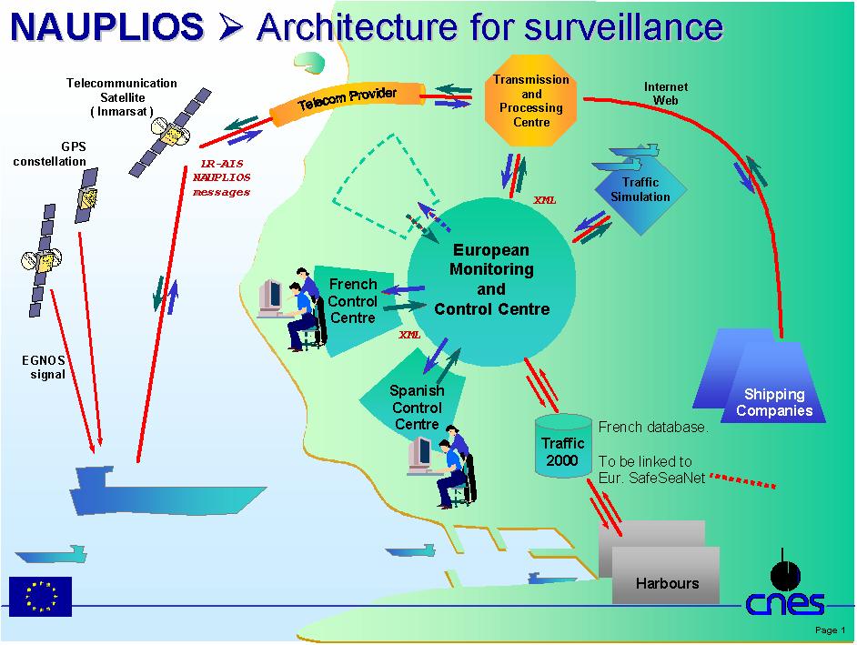
15 NAUPLIOS Architecture 6 Demo Vessels FARGIS 05, 1 March

16 Main Research Activities SWP 2.2 SWP 2.2 Integration of AIS and Synthetic Aperture Radar Combining Synthetic Aperture Radar and LR-AIS/LRIT for Vessel Detection and possible tracking; Standardisation of information related to oil spill detected from Synthetic Aperture Radar; Presentation of the above information integrated in a VTS or Coast Guard environment. FARGIS 05, 1 March

17 Integration of LR-AIS/LRIT and SAR in a VTS environment LR-AIS/LRIT messages Synthetic Aperture Radar Imagery FARGIS 05, 1 March


18 Main Research Activities SWP 2.3 SWP 2.3 Non-AIS Location Information Monitoring Use of mobile phone or other non-ais radio network services for identification and location of smaller, SOLAS exempt vessels SW tools for registration and promulgation of identification and position information Use of PDAs and other portable devices for reception and presentation of identification and position information FARGIS 05, 1 March
19 Conclusions Expected overall results: LR-AIS/LRIT Technical proposals Integrated stategic traffic images Pollution enforcement by combining pollution information with information on a strategic traffic image Technical proposals for small vessel AIS FARGIS 05, 1 March
20 Thank you for your attention Any Questions? WORLD CLASS through people, technology and dedication WORLD CLASS through people, technology and dedication KONGSBERG March 10,
Global Maritime Distress and Safety System (GMDSS)
") Global Maritime Distress and Safety System (GMDSS) Global Maritime Distress and Safety System (GMDSS) BACKGROUNG, APPLICATION, DEFINITION GMDSS (Background) SOLAS 74 Ships 1600 TRG Radio Installation Ships
Global Maritime Distress and Safety System (GMDSS) Global Maritime Distress and Safety System (GMDSS) BACKGROUNG, APPLICATION, DEFINITION GMDSS (Background) SOLAS 74 Ships 1600 TRG Radio Installation Ships
GMDSS modernisation and e-navigation: spectrum needs
 ETSI Workshop "Future Evolution of Marine Communication", 7-8 November 2017, Sophia Antipolis, France GMDSS modernisation and e-navigation: spectrum needs Karlis Bogens BR Terrestrial Services Department
GMDSS communication systems
 GMDSS Basic Concepts A System Overview Functional requirements The GMDSS (Global Maritime Distress and Safety System) is specifically designed to automate a ship's radio distress alerting function, and,
Demonstrator of a Data Processing Centre (DPC) for satellite-based AIS services
 for satellite-based AIS services") Page 1 Demonstrator of a Data Processing Centre (DPC) for satellite-based AIS services 19/20 April 2012 gfabritius@cls.fr Overview of the presentation Page 2 Introducing CLS Introducing AIS / SAT-AIS Scope
Page 1 Demonstrator of a Data Processing Centre (DPC) for satellite-based AIS services 19/20 April 2012 gfabritius@cls.fr Overview of the presentation Page 2 Introducing CLS Introducing AIS / SAT-AIS Scope
ESA IAP Blue Belt demonstration project:
 Page 1 ESA IAP Blue Belt demonstration project: supporting the European Maritime Safety Agency (EMSA) Blue Belt Project, by providing a service based on satellite based AIS data complementing the terrestrial
Satellite services for maritime security
 Satellite services for ITS-T Sophia Antipolis 6 June 2007 Jean-Pierre Cauzac, CLS - Collecte Localisation Satellites 35 Are the seas becoming more dangerous? IMB report 2006 shows improvement: 239 piracy
L AGENCE NATIONALE DES FREQUENCES (ANFR) From Titanic to satellite from Morse to digital Entry in a new era for the maritime community
 From Titanic to satellite from Morse to digital Entry in a new era for the maritime community") L AGENCE NATIONALE DES FREQUENCES (ANFR) From Titanic to satellite from Morse to digital Entry in a new era for the maritime community ITU regional seminar 6-8 June 2018 St-Petersburg, Russian Federation
L AGENCE NATIONALE DES FREQUENCES (ANFR) From Titanic to satellite from Morse to digital Entry in a new era for the maritime community ITU regional seminar 6-8 June 2018 St-Petersburg, Russian Federation
COMMUNICATIONS FOR MARITIME SAFETY AND EFFICIENCY. Francis Zachariae, Secretary-General, IALA
 COMMUNICATIONS FOR MARITIME SAFETY AND EFFICIENCY Francis Zachariae, Secretary-General, IALA IALA and its Purpose Non profit, international technical association established in 1957 Two Goals aimed at
Maritime Communications
 Maritime Communications Strategic Sectorial Spectrum Needs Conferência sobre Gestão do Espectro: Perspectivas, Desafios e Estratégias Lisboa, 20 de setembro de 2013 RSPG Work Programme 2012 and Beyond
This circular summarizes the various important aspects of the LRIT system with a view to enabling companies to ensure compliance in a timely manner.
 Luxembourg, 29/10/2008 CIRCULAR CAM 02/2008 N/Réf. : AH/63353 Subject : Long-Range Identification and Tracking of Ships (LRIT) To : All ship owners, ship operators and designated persons of Luxembourg
VDES: Next Generation AIS in the Review & Modernization of the GMDSS
 JCG GMDSS Symposium VDES: Next Generation AIS in the Review & Modernization of the GMDSS 19 November 2013 VDES: Next Generation AIS Contents 1. Present situation & Problems GMDSS & AIS 2. Future: from
VHF Data Exchange System (VDES)
") VHF Data Exchange System (VDES) ETSI Workshop Future Evolution of Marine Communication 7-8 November 2017 Malcolm Lyman Marketing Manager CML Microcircuits UK With acknowledgments to the members of IALA
VHF Data Exchange System (VDES) ETSI Workshop Future Evolution of Marine Communication 7-8 November 2017 Malcolm Lyman Marketing Manager CML Microcircuits UK With acknowledgments to the members of IALA
The Future in Marine Radio Communication GMDSS. Department of Transportation United States Coast Guard
 The Future in Marine Radio Communication GMDSS Department of Transportation United States Coast Guard Do you use a Maritime Radio System? If so, the new Global Maritime Distress and Safety System (GMDSS)
Digital broadcasting systems under development within ITU-R of interest for the maritime community
 Digital broadcasting systems under development within ITU-R of interest for the maritime community Christian RISSONE ANFR rissone@anfr.fr IHO, WWNWS 5 Monaco, 2 nd October 2013 1 Background for the 500
ATTACHMENT E. How to Conduct a GMDSS Inspection.
 Page 1 of 7 NOTE: This document is an excerpt from The Report and Order In the Matter of Amendment of the Commission's Rules Concerning the Inspection of Radio Installations on Large Cargo and Small Passenger
What are the GMDSS requirements?
 What are the GMDSS requirements? Minimum requirements GMDSS ships are required to carry the following minimum equipment: A VHF radio installation capable of transmitting DSC on channel 70, and radiotelephony
RULES FOR THE CONSTRUCTION AND CLASSIFICATION OF MOBILE OFFSHORE DRILLING UNITS TITLE MOBILE OFFSHORE DRILLING UNITS NAUTIC AND ELECTRONICS CHAPTERS
 PARTE II RULES FOR THE CONSTRUCTION AND CLASSIFICATION OF MOBILE OFFSHORE DRILLING UNITS TITLE MOBILE OFFSHORE DRILLING UNITS SECTION 8 NAUTIC AND ELECTRONICS CHAPTERS A B C D SCOPE TECHNICAL DOCUMENTATION
OPERATIONS SEAFARER CERTIFICATION GUIDANCE NOTE SA MARITIME QUALIFICATIONS CODE SHORT RANGE CERTIFICATE (SRC)
") Page 1 of 8 Compiled by Chief Examiner Approved by Senior Radio Examiner OPERATIONS SEAFARER CERTIFICATION GUIDANCE NOTE SA MARITIME QUALIFICATIONS CODE SHORT Page 2 of 8 SHORT : OUTLINE EXAMINATION SYLLABUS
Page 1 of 8 Compiled by Chief Examiner Approved by Senior Radio Examiner OPERATIONS SEAFARER CERTIFICATION GUIDANCE NOTE SA MARITIME QUALIFICATIONS CODE SHORT Page 2 of 8 SHORT : OUTLINE EXAMINATION SYLLABUS
GMDSS for Recreational Boaters
 GMDSS for Recreational Boaters OVERVIEW The Global Maritime Distress and Safety System (GMDSS) is an international system using advanced communications technology. Development of GMDSS was initiated by
GMDSS RADIO INSTALLATION
 Ship s name: N.R. Survey: GMDSS RADIO INSTALLATION (Res. A.1053(27)) INITIAL (Newconstruction) PERIODICAL RENEWAL Sea areas: A1 Methods of maintenance: Duplication of (Reg. IV/12-15) A1+A2 (Reg. IV/15)
Technology evolution for future radiocommunication and navigation
 Technology evolution for future radiocommunication and navigation Frances Baskerville (Secretary General) Richard Doherty (Deputy Secretary General) CIRM Who we are and what we do What is CIRM? The Worldwide
IMO GUIDELINES TO ADMINISTRATIONS ON REPORTING FALSE ALERTS
 INTERNATIONAL MARITIME ORGANIZATION 4 ALBERT EMBANKMENT LONDON SE1 7SR Telephone: 020 7735 7611 Fax: 020 7587 3210 Telex: 23588 IMOLDN G IMO E Ref. T2/6.04 MSC/Circ.1078 6 June 2003 GUIDELINES TO ADMINISTRATIONS
REVISED QUESTIONNAIRE ON SHORE-BASED FACILITIES FOR THE GLOBAL MARITIME DISTRESS AND SAFETY SYSTEM (GMDSS)
") E 4 ALBERT EMBANKMENT LONDON SE1 7SR Telephone: +44 (0)20 7735 7611 Fax: +44 (0)20 7587 3210 MSC.1/Circ.1382/Rev.2 24 June 2013 REVISED QUESTIONNAIRE ON SHORE-BASED FACILITIES FOR THE GLOBAL MARITIME DISTRESS
E 4 ALBERT EMBANKMENT LONDON SE1 7SR Telephone: +44 (0)20 7735 7611 Fax: +44 (0)20 7587 3210 MSC.1/Circ.1382/Rev.2 24 June 2013 REVISED QUESTIONNAIRE ON SHORE-BASED FACILITIES FOR THE GLOBAL MARITIME DISTRESS
TECHNICAL COMMITTEE 80: MARITIME NAVIGATION AND RADIOCOMMUNICATION EQUIPMENT AND SYSTEMS INTERNATIONAL ELECTROTECHNICAL COMMISSION
 TECHNICAL COMMITTEE 80: MARITIME NAVIGATION AND RADIOCOMMUNICATION EQUIPMENT AND SYSTEMS INTERNATIONAL ELECTROTECHNICAL COMMISSION IEC TECHNICAL COMMITTEE 80: MARITIME NAVIGATION AND RADIOCOMMUNICATION
Record of approved GMDSS radio installation
 (Nov 2015) Record of approved GMDSS radio installation To meet the provisions of the INTERNATIONAL CONVENTION FOR THE SAFETY OF LIFE AT SEA, 1974, AND AMENDMENTS THERETO This form should be kept on board
MARITIME RADIO SYSTEMS FOR DISTRESS ALERTING
 Journal of KONES Powertrain and Transport, Vol. 25, No. 1 2018 MARITIME RADIO SYSTEMS FOR DISTRESS ALERTING Karol Korcz Gdynia Maritime University Department of Marine Telecommunication Morska Street 81-87,
Applications of Satellite-AIS (S-AIS) for Search and Rescue
 for Search and Rescue") Business White Paper Applications of Satellite-AIS (S-AIS) for Search and Rescue Executive Summary Automatic Identification System (AIS) is a mandatory 1 navigation safety communications system under the
Business White Paper Applications of Satellite-AIS (S-AIS) for Search and Rescue Executive Summary Automatic Identification System (AIS) is a mandatory 1 navigation safety communications system under the
Satellite technology to prevent and respond in cases of maritime accidents
 United Nations International Conference on Space-based Technologies for Disaster Management "Disaster risk identification, assessment and monitoring" 23-25 October 2013, Beijing, China. Satellite technology
An Introduction to INDUSTRY PARTNERS 25/05/2017. Military Army & Air Force. Government Defense & Rescue. Aviation Maritime Military. Other.
 An Introduction to 1 INDUSTRY PARTNERS Aviation Maritime Military Coast Guard & Navy Military Army & Air Force Government Defense & Rescue Other Commercial Commercial/Workboat Navy Air Force SAR Agencies
ITU Service Publications (maritime) and MARS (Maritime mobile Access and Retrieval System)
 and MARS (Maritime mobile Access and Retrieval System)") ITU Service Publications (maritime) and MARS (Maritime mobile Access and Retrieval System) ITU Radiocommunication Bureau Ms. Sujiva Pinnagoda pinnagoda@itu.int BR/TSD/TPR Another BR activity Radiocommunication
ITU Service Publications (maritime) and MARS (Maritime mobile Access and Retrieval System) ITU Radiocommunication Bureau Ms. Sujiva Pinnagoda pinnagoda@itu.int BR/TSD/TPR Another BR activity Radiocommunication
COMMUNICATION SYSTEMS FOR SAFETY AND SECURITY OF SHIPS
 Journal of KONES Powertrain and Transport, Vol. 23, No. 1 2016 COMMUNICATION SYSTEMS FOR SAFETY AND SECURITY OF SHIPS Karol Korcz Gdynia Maritime University, Department of Marine Telecommunication Morska
International Maritime Organization DRAFT IMO POSITION ON WRC-19 AGENDA ITEMS CONCERNING MATTERS RELATING TO MARITIME SERVICES
 2 nd ITU INTER-REGIONAL WORKSHOP ON WRC-19 PREPARATION Geneva, 20 22 November 2018 Document 12 November 2018 English only International Maritime Organization DRAFT IMO POSITION ON WRC-19 AGENDA ITEMS CONCERNING
ROUTEING OF SHIPS, SHIP REPORTING AND RELATED MATTERS. Establishment of a Mandatory Ship Reporting System in the
 INTERNATIONAL MARITIME ORGANIZATION E SUB-COMMITTEE ON SAFETY OF NAVIGATION 48th session Agenda item 3 IMO NAV 48/3/2 11 April 2002 Original: ENGLISH ROUTEING OF SHIPS, SHIP REPORTING AND RELATED MATTERS
CEPT/ERC/RECOMMENDATION E (Bonn 1994)
") CEPT/ERC/RECOMMENDATION 31-05 E (Bonn 1994) Page 1 HARMONISED EXAMINATION PROCEDURES FOR MARITIME RADIO OPERATOR S CERTIFICATES APPROPRIATE TO VESSELS WHICH USE THE FREQUENCIES AND TECHNIQUES OF THE GLOBAL
CEPT/ERC/RECOMMENDATION 31-05 E (Bonn 1994) Page 1 HARMONISED EXAMINATION PROCEDURES FOR MARITIME RADIO OPERATOR S CERTIFICATES APPROPRIATE TO VESSELS WHICH USE THE FREQUENCIES AND TECHNIQUES OF THE GLOBAL
RESOLUTION A.659(16) adopted on 19 October 1989 PROVISION OF RADIO SERVICES FOR THE GLOBAL MARITIME DISTRESS AND SAFETY SYSTEM
 adopted on 19 October 1989 PROVISION OF RADIO SERVICES FOR THE GLOBAL MARITIME DISTRESS AND SAFETY SYSTEM") INTERNATIONAL MARITIME ORGANIZATION RESOLUTION A.659(16) adopted on 19 October 1989 A 16/Res.659 30 November 1989 Original: ENGLISH ASSEMBLY - 16th session Agenda item 10 IMO RESOLUTION A.659(16) adopted
INTERNATIONAL MARITIME ORGANIZATION RESOLUTION A.659(16) adopted on 19 October 1989 A 16/Res.659 30 November 1989 Original: ENGLISH ASSEMBLY - 16th session Agenda item 10 IMO RESOLUTION A.659(16) adopted
QUESTIONNAIRE ON SHORE-BASED FACILITIES FOR THE GLOBAL MARITIME DISTRESS AND SAFETY SYSTEM (GMDSS)
") E 4 ALBERT EMBANKMENT LONDON SE1 7SR Telephone: +44 (0)20 7735 7611 Fax: +44 (0)20 7587 3210 Ref. T2-OSS/2.6 MSC.1/Circ.1382 3 December 2010 QUESTIONNAIRE ON SHORE-BASED FACILITIES FOR THE GLOBAL MARITIME
E 4 ALBERT EMBANKMENT LONDON SE1 7SR Telephone: +44 (0)20 7735 7611 Fax: +44 (0)20 7587 3210 Ref. T2-OSS/2.6 MSC.1/Circ.1382 3 December 2010 QUESTIONNAIRE ON SHORE-BASED FACILITIES FOR THE GLOBAL MARITIME
International Maritime Organization
 1st ITU Inter-regional Workshop on WRC-19 Preparation Geneva, 21-22 November 2017 Received: 9 November 2017 Document 10 November 2017 English only International Maritime Organization DRAFT IMO POSITION
Bill Kautz U.S. Coast Guard Telecommunications Manager IALA e NAV Committee AIS/COMMS WG Vice Chair
 Bill Kautz U.S. Coast Guard Telecommunications Manager IALA e NAV Committee AIS/COMMS WG Vice Chair Discussion WRC 12 Results WRC 15 Agenda Item 1.16 Resolution 360 (WRC 12) ITU R WP5B VHF Data Exchange
Weatherdock explains: How does real DSC work in an emergency transmitter?
 explains: How does real DSC work in an emergency transmitter? 1 DSC Basics 2 AIS S.A.R.T. & DSC easyrescue-pro 3 DSC closed loop 4 DSC open loop 1 DSC Basics DSC is short cut for Digital Selective Call
RF Monitoring Service Profile Based on AIS Binary Message
 , pp.55-59 http://dx.doi.org/10.14257/astl.2015.108.13 RF Monitoring Service Profile Based on AIS Binary Message Soyoung Hwang Catholic University of Pusan, 609-757 Busan, South Korea soyoung@cup.ac.kr
JOURNAL OF MARITIME RESEARCH. The Architecture of Data Transmission in Inland Navigation
 JOURNAL OF MARITIME RESEARCH Vol XI. No. II (2014) pp 3 7 ISSN: 1697-4040, www.jmr.unican.es The Architecture of Data Transmission in Inland Navigation A. Lisaj 1,2, and P. Majzner 3 ARTICLE INFO Article
LRIT spectrum, cybersecurity and other ITU related activities
 IMSO Seminar Effective Implementation and Management of the LRIT System 15 16 February 2018, London, UK LRIT spectrum, cybersecurity and other ITU related activities Nikolai Vassiliev Chief, Terrestrial
All IMO Member States Intergovernmental organizations Non-governmental organizations in consultative status with IMO
 E 4 ALBERT EMBANKMENT LONDON SE1 7SR Telephone: +44 (0)20 7735 7611 Fax: +44 (0)20 7587 3210 9 May 2018 To: Subject: All IMO Member States Intergovernmental organizations Non-governmental organizations
RESOLUTION MSC.278(85) (adopted on 1 December 2008) ADOPTION OF THE NEW MANDATORY SHIP REPORTING SYSTEM "OFF THE COAST OF PORTUGAL - COPREP"
 (adopted on 1 December 2008) ADOPTION OF THE NEW MANDATORY SHIP REPORTING SYSTEM OFF THE COAST OF PORTUGAL - COPREP") MSC 85/26/Add.1 RESOLUTION MSC.278(85) SYSTEM OFF THE COAST OF PORTUGAL COPREP THE MARITIME SAFETY COMMITTEE, RECALLING Article 28 of the Convention on the International Maritime Organization concerning
MSC 85/26/Add.1 RESOLUTION MSC.278(85) SYSTEM OFF THE COAST OF PORTUGAL COPREP THE MARITIME SAFETY COMMITTEE, RECALLING Article 28 of the Convention on the International Maritime Organization concerning
IS Shore Based Maintenance. Definition and Pricing
 IS Shore Based Maintenance Definition and Pricing Content 1 IS SBM Basic - Mandatory Annual Tests... 3 2 IS SBM Basic Com - Mandatory Annual Tests plus Communication Equipment... 4 3 IS SBM Nav - Mandatory
Market strategy update in Maritime segment. This presentation can be interpreted only together with the oral comments accompanying it
 Market strategy update in Maritime segment This presentation can be interpreted only together with the oral comments accompanying it 2 Market sub-segments and applications Recreational navigation: GNSS
MEMORANDUM NO MAY Directives Affected. Reference (a) is temporarily augmented by this policy letter.
 is temporarily augmented by this policy letter.") U.S. Department of Commandant 2100 Second Street, S.W. Homeland Security United States Coast Guard Washington, DC 20593-0001 Staff Symbol: -1 Phone: (202) 267-2735 United States Fax: (202) 267-4394 Coast
U.S. Department of Commandant 2100 Second Street, S.W. Homeland Security United States Coast Guard Washington, DC 20593-0001 Staff Symbol: -1 Phone: (202) 267-2735 United States Fax: (202) 267-4394 Coast
Extent of Consultation
 Objective Parts 40A, 40C and 40D prescribe design, construction and equipment requirements for passenger ships that are not SOLAS ships, non-passenger ships that are not SOLAS ships and fishing ships.
RESOLUTION MSC.229(82) (adopted on 5 December 2006) ADOPTION OF A NEW MANDATORY SHIP REPORTING SYSTEM "IN THE GALAPAGOS PARTICULARLY SENSITIVE SEA
 (adopted on 5 December 2006) ADOPTION OF A NEW MANDATORY SHIP REPORTING SYSTEM IN THE GALAPAGOS PARTICULARLY SENSITIVE SEA") MSC 82/24/Add.2 RESOLUTION MSC.229(82) IN THE GALAPAGOS PARTICULARLY SENSITIVE SEA AREA (PSSA) (GALREP) THE MARITIME SAFETY COMMITTEE, RECALLING Article 28(b) of the Convention on the International Maritime
MSC 82/24/Add.2 RESOLUTION MSC.229(82) IN THE GALAPAGOS PARTICULARLY SENSITIVE SEA AREA (PSSA) (GALREP) THE MARITIME SAFETY COMMITTEE, RECALLING Article 28(b) of the Convention on the International Maritime
D1.15 Draft Chapter 4 (e-navigation) for the 2018 Edition of the IALA NAVGUIDE
 for the 2018 Edition of the IALA NAVGUIDE") D1.15 Draft Chapter 4 (e-navigation) for the 2018 Edition of the IALA NAVGUIDE Project no. 636329 Project acronym: EfficienSea2 EFFICIENSEA2 efficient, safe and sustainable traffic at sea Funding scheme:
D1.15 Draft Chapter 4 (e-navigation) for the 2018 Edition of the IALA NAVGUIDE Project no. 636329 Project acronym: EfficienSea2 EFFICIENSEA2 efficient, safe and sustainable traffic at sea Funding scheme:
IMO RESOLUTION A.1001(25) Adopted on 29 November 2007 (Agenda item 9)
 Adopted on 29 November 2007 (Agenda item 9)") INTERNATIONAL MARITIME ORGANIZATION E IMO ASSEMBLY 25th session Agenda item 9 A 25/Res.1001 3 January 2008 Original: ENGLISH RESOLUTION A.1001(25) Adopted on 29 November 2007 (Agenda item 9) CRITERIA FOR
INTERNATIONAL MARITIME ORGANIZATION E IMO ASSEMBLY 25th session Agenda item 9 A 25/Res.1001 3 January 2008 Original: ENGLISH RESOLUTION A.1001(25) Adopted on 29 November 2007 (Agenda item 9) CRITERIA FOR
GUIDANCE ON THE COSPAS-SARSAT INTERNATIONAL 406 MHz BEACON REGISTRATION DATABASE
 E ALBERT EMBANKMENT LONDON SE1 7SR Telephone: +44 (0)20 7735 7611 Fax: +44 (0)20 7587 3210 GUIDANCE ON THE COSPAS-SARSAT INTERNATIONAL 406 MHz BEACON REGISTRATION DATABASE MSC.1/Circ.1210/Rev.1 21 November
MARITIME COMMUNICATIONS IDENTIFYING CURRENT AND FUTURE SATELLITE REQUIREMENTS & TECHNOLOGIES
 MARITIME COMMUNICATIONS IDENTIFYING CURRENT AND FUTURE SATELLITE REQUIREMENTS & TECHNOLOGIES Simon Plass and Federico Clazzer Institute of Communications and Navigation, German Aerospace Center (DLR),
GMISS IALA and Maritime Information Sharing
 International Association of Marine Aids to Navigation and Lighthouse Authorities Association Internationale de Signalisation Maritime IALA and Maritime Information Sharing R.Adm. Jean-Charles Leclair
NAVIGA TIONAL VIGA WARNINGS/MSI/GMDSS N NAV NA AREA III VIII
 NAVIGATIONAL WARNINGS/MSI/GMDSS IN NAVAREA VIII 5/16/2008 1 SCOPE OF PRESENTATION 1. Introduction 2. Navarea VIII Radio Warnings 3. Indian Notices to Mariners 4. Implementation of GMDSS 5. Marine Safety
Meeting 5 18 July 2013 Agenda Item 2.1. Submitted by IHB SUMMARY
 WWNWS WWNWS5/2/1a Meeting 5 18 July 2013 Agenda Item 2.1 Report of 8 th Meeting of IMO/ITU EG Submitted by IHB SUMMARY Executive Summary: This document provides details of the outcomes of the 8 th meeting
Space Based Vessel Detection - Combining Earth Observation and AIS for Maritime surveillance TEXAS V and C-Σ III
 Space Based Vessel Detection - Combining Earth Observation and AIS for Maritime surveillance TEXAS V and C-Σ III Tony Bauna Director, Product and Service Development, Kongsberg Satellite Services, Tromsø,
American Marine Training Center, LLC AMTC (2682)
") American Marine Training Center, LLC www.americanmarinetc.com 1-855-344-AMTC (2682) (This is the FCC Commercial Element 7R Question Pool. It has been edited to make it more user friendly to assist as a
American Marine Training Center, LLC www.americanmarinetc.com 1-855-344-AMTC (2682) (This is the FCC Commercial Element 7R Question Pool. It has been edited to make it more user friendly to assist as a
Circular. Notice of Requirement for Medical Oxygen Cylinder and EPRIB
 CCS Circular To: CCS surveyors, Auditors, Marshall Islands Ship owners and Ship managers, Radio inspection company China Classification Society (2011)Circ. No.21 Total No.85 Apr. 21, 2011 (Total pages:
A new Modular and Open Concept for the Maritime Integrated PNT System
 A new Modular and Open Concept for the Maritime Integrated PNT System T. Noack German Aerospace Center Institute of Communications and Navigation www.dlr.de Chart 2 MTS-2012 Maritime Integrated PNT Unit
AMSA Case Study. Helping the MV Akademik Shokalskiy out of hot water. INMARSAT > Case study > AMSA
 AMSA Case Study Helping the MV Akademik Shokalskiy out of hot water INMARSAT > Case study > AMSA Breaking the Ice with Satellite Communications Not one of the 74 passengers and crew aboard the Russian
Satellite data for Maritime Operations. Andreas Hay Kaljord Project Manager Energy, Environment & Security
 Satellite data for Maritime Operations Andreas Hay Kaljord Project Manager Energy, Environment & Security Kongsberg Satellite Services (KSAT) World leading provider within our business area Supports 85
REVIEW AND MODERNIZATION OF THE GMDSS. Report of the Correspondence Group - First draft of the high level review. Submitted by the United States
 E JOINT IMO/ITU EXPERTS GROUP ON MARITIME RADIOCOMMUNICATION MATTERS 8th session Agenda item 4 IMO/ITU EG 8/4/1 14 September 2012 ENGLISH ONLY REVIEW AND MODERNIZATION OF THE GMDSS Report of the Correspondence
MARITIME MANAGEMENT Receive and transmit information
 1 of 5 level: 4 credit: 18 planned review date: July 2006 sub-field: purpose: entry information: accreditation option: moderation option: special notes: Maritime People credited with this unit standard
IMO WORLD-WIDE RADIONAVIGATION SYSTEM (WWRNS) GALILEO receiver performance standards. Submitted by the European Commission
 GALILEO receiver performance standards. Submitted by the European Commission") INTERNATIONAL MARITIME ORGANIZATION E IMO SUB-COMMITTEE ON SAFETY OF NAVIGATION 50th session Agenda item 13 2 April 2004 Original: ENGLISH WORLD-WIDE RADIONAVIGATION SYSTEM (WWRNS) GALILEO receiver performance
INTERNATIONAL MARITIME ORGANIZATION E IMO SUB-COMMITTEE ON SAFETY OF NAVIGATION 50th session Agenda item 13 2 April 2004 Original: ENGLISH WORLD-WIDE RADIONAVIGATION SYSTEM (WWRNS) GALILEO receiver performance
E-Navigation: Opening the door to the future
 International Association of Marine Aids to Navigation and Lighthouse Authorities E-Navigation: Opening the door to the future E-Navigation Underway North America November 2018 Secretary-General Francis
Using AIS to identify and investigate ferry accidents
 Using AIS to identify and investigate ferry accidents David Hewson Antenna Network Manager Genscape Vesseltracker info@genscape.com DE: +49 (0) 97 07 86 10 EU: +31 20 524 4089 Background Vesseltracker
Satellite Technologies for Fisheries Monitoring, Control and Surveillance (MCS)
") JRC IPSC Maritime Affairs 1 Satellite Technologies for Fisheries Monitoring, Control and Surveillance (MCS) Juan Cicuendez, Marlene Alvarez JRC Info Day Madrid, 2 June 2010 IPSC - Institute for the Protection
JRC IPSC Maritime Affairs 1 Satellite Technologies for Fisheries Monitoring, Control and Surveillance (MCS) Juan Cicuendez, Marlene Alvarez JRC Info Day Madrid, 2 June 2010 IPSC - Institute for the Protection
Development of VDES in IALA
 Development of VDES in IALA 2:nd Workshop on International Standardization of VDES Rolf Zetterberg Swedish Marime Administration Swedish Maritime Administration SMA SMA responsible for Fairways and AtoN
1
 12/20/2016 www.made-simplefor-cruisers.com 1 Emergency Position Indicating Radio Beacons (EPIRB) Only 406.0-406.1 EPIRBs with a built in GPS will be authorized for sale in the US. EPIRBs without position
Emergency Marine Communications
 Emergency Marine Communications Presented by: Steve Chamberlin Content:Chuck Hawley Safety at Sea Seminar US Sailing Goals of Emergency Communications To alert rescue services to your situation To get
E-NAVIGATION AND BEYOND
 E-NAVIGATION AND BEYOND The Work of IALA e-navigation Committee and Future CDR. Hideki NOGUCHI, Chair, IALA ENAV Committee e-navigation (ENAV) Committee Established in 2010 by merging R-NAV and AIS Committee
FOURTH SESSION OF THE SUB-COMMITTEE ON NAVIGATION, COMMUNICATIONS AND SEARCH AND RESCUE 6 to 10 March 2017
 INTERNATIONAL REGULATIONS COMMISSION BRIEF FOURTH SESSION OF THE SUB-COMMITTEE ON NAVIGATION, COMMUNICATIONS AND SEARCH AND RESCUE 6 to 10 March 2017 1 GENERAL The Sub-Committee on Navigation, Communications
The Role of Automatic Identification System (AIS) in Enhancing Vessel Traffic Management By Capt. Ehab Ibrahim Etman
 in Enhancing Vessel Traffic Management By Capt. Ehab Ibrahim Etman") The Role of Automatic Identification System (AIS) in Enhancing Vessel Traffic Management By Capt. Ehab Ibrahim Etman Abstract The International Maritime Organization (IMO) adopted a new requirement for
The Role of Automatic Identification System (AIS) in Enhancing Vessel Traffic Management By Capt. Ehab Ibrahim Etman Abstract The International Maritime Organization (IMO) adopted a new requirement for
Document code: 6/2/INF Date: Submitted by: Chairman DRAFT PROPOSAL FOR OPERATIONAL DEFINITIONS OF AIS COVERAGE.
 HELSINKI COMMISSION HELCOM AIS EWG 21/2010 Expert Working Group for Mutual Exchange and Deliveries of AIS data 21 st Meeting Gdynia, Poland, 27-28 October 2010 Agenda Item 6 Definition of AIS coverage
Doug Miller Milltech Marine Inc. Milltech Marine 1
 Doug Miller Milltech Marine Inc. www.milltechmarine.com Milltech Marine 1 What I ll Cover What is AIS? AIS Transponders AIS Receivers Typical Usage Scenarios What s new and what s coming Questions Milltech
NC4FB FCC Commercial License Element 7 Questions
 NC4FB FCC Commercial License Element 7 Questions 1. 7-001A What is the fundamental concept of the GMDSS? A. It is intended to automate and improve emergency communications in the maritime industry. B.
Absolute Positioning by Radar
 Absolute Positioning by Radar Dr Nick Ward, Research Director General Lighthouse Authorities of UK & Ireland 14th IAIN Congress 2012, 01-03 October, 2012 - Cairo, Egypt Seamless Navigation (Challenges
Maritime Safety and Security Information Exchange System new possibilities based on modern IT technologies
 Maritime Safety and Security Information Exchange System new possibilities based on modern IT technologies HELCOM AIS EWG 21/2010, 27-28 October 2010 Artur Baranowski artur.baranowski@sprint.pl Michał
IALA S WORK IN E-NAVIGATION. Michael Card
 IALA S WORK IN E-NAVIGATION Michael Card e-navigation origins The early work of IALA on e-navigation Multiple Initiatives EfficienSea 2 STM Validation IHO S-100 and IALA S-200 Smart Navigation VDES development
AIS Training. AIS Technology in Digital Yacht Products Explained. Digital Yacht Ltd TEL
 AIS Training AIS Technology in Digital Yacht Products Explained Digital Yacht Ltd www.digitalyacht.co.uk TEL + 44 1179 554474 What is AIS? The Automatic Identification System (AIS) is the biggest advance
Communication & Safety at Sea
 Ocean Signal Ltd. Unit 4, Ocivan Way Margate CT9 4NN United Kingdom info@oceansignal.com +44 1843 282930 Communication & Safety at Sea Introducing Ocean Signal The Range Ocean Signal specialises in the
UNIVERSAL AUTOMATIC IDENTIFICATION SYSTEM
 IALA GUIDELINES ON THE UNIVERSAL AUTOMATIC IDENTIFICATION SYSTEM (AIS) Volume 1, Part II Technical Issues Edition 1.1 December 2002 IALA / AISM 20ter rue Schnapper 78100 Saint Germain en Laye France Tel
RECOMMENDATION ITU-R M.541-8*
 Rec. ITU-R M.541-8 1 RECOMMENDATION ITU-R M.541-8* OPERATIONAL PROCEDURES FOR THE USE OF DIGITAL SELECTIVE-CALLING EQUIPMENT IN THE MARITIME MOBILE SERVICE (Question ITU-R 9/8) (1978-1982-1986-1990-1992-1994-1995-1996-1997)
ITU 'Young ICT Leaders Forum 2015' Maritime digital communication for e-navigation (WED) Daeho Kim ETRI
 Daeho Kim ETRI") ITU 'Young ICT Leaders Forum 2015' Maritime digital communication for e-navigation 2015. 12. 9. (WED) Daeho Kim ETRI 2 GMDSS GMDSS Communication 3 e-navigation Roadmap e-nav Proposal Adoption approval(imo)
ITU 'Young ICT Leaders Forum 2015' Maritime digital communication for e-navigation 2015. 12. 9. (WED) Daeho Kim ETRI 2 GMDSS GMDSS Communication 3 e-navigation Roadmap e-nav Proposal Adoption approval(imo)
02 Issue. e-navigation News. GNSS Vulnerability. Dublin Bay Digital Diamond. e-navigation. Demonstrator Update International. e-navigation.
 CORPORATE SECURITY TEAMWORK EVENTS 02 Issue e-navigation News GNSS Vulnerability Dublin Bay Digital Diamond e-navigation Demonstrator Update International e-navigation update June 2014 www.cil.ie +353
INTERNATIONAL STANDARD
 INTERNATIONAL STANDARD IEC 61993-2 First edition 2001-12 Maritime navigation and radiocommunication equipment and systems Automatic identification systems (AIS) Part 2: Class A shipborne equipment of the
SAFELINK EPIRB (WITH GPS) 406 Beacon Specification. Meets the requirements of international standards:
 406 Beacon Specification. Meets the requirements of international standards:") SAFELINK EPIRB (WITH GPS) 406 Beacon Specification Meets the requirements of international standards: IEC 61097 2 2008, IEC/EN 60945 Fourth edition (2002 08), ETSI 300 066 v1.3.1 (2001 01), RTCM SC110
SAFELINK EPIRB (WITH GPS) 406 Beacon Specification Meets the requirements of international standards: IEC 61097 2 2008, IEC/EN 60945 Fourth edition (2002 08), ETSI 300 066 v1.3.1 (2001 01), RTCM SC110
Communication & Safety at Sea
 Communication & Safety at Sea English Introducing Ocean Signal Ocean Signal specialises in the development and manufacture of advanced communication and safety products for the marine market. With one
Marine Radio Communication
 Sixth edition The very latest technological advances in terrestrial and satellite communications Changes to the international VHF channel allocation and channel spacing The major overhaul of the organisational
Technical Details and Guidelines for VDES Implementation
 Technical Details and Guidelines for VDES Implementation 2 nd Workshop on VDES Tokyo, Japan 20-24 January 2014 By: Ross Norsworthy Contributions from: Stefan Bober, IALA e-nav Committee 1 Data transmission
CASE STUDY OF THE ICELANDIC INTEGRATED SYSTEM FOR MONITORING, CONTROL AND SURVEILLANCE
 FAO Fisheries and Aquaculture Circular No. 1053 FIRO/C1053 (En) ISSN 2070-6065 CASE STUDY OF THE ICELANDIC INTEGRATED SYSTEM FOR MONITORING, CONTROL AND SURVEILLANCE Copies of FAO publications can be requested
New advanced real time smart Search and Rescue RADAR Transponder (SART)
") Current Science International Volume : 07 Issue : 02 April- June 2018 Pages: 128-134 New advanced real time smart Search and Rescue RADAR Transponder (SART) M. S. Zaghloul Electronics and Communication
Current Science International Volume : 07 Issue : 02 April- June 2018 Pages: 128-134 New advanced real time smart Search and Rescue RADAR Transponder (SART) M. S. Zaghloul Electronics and Communication
ANNEX ANNEX. Accompanying the document. Commission Implementing Regulation
 Ref. Ares(2018)3546601-04/07/2018 EUROPEAN COMMISSION Brussels, XXX [ ](2018) XXX draft ANNEX ANNEX Accompanying the document Commission Implementing Regulation on technical specifications for vessel tracking
Korea s Strategy for e-navigation. SMART-Navigation. Presented by. Bu Young, Kim. 28 May Ministry of Oceans and Fisheries Republic of Korea
 Korea s Strategy for e-navigation SMART-Navigation Presented by Bu Young, Kim 28 May 2014 Ministry of Oceans and Fisheries Republic of Korea 1 2 3 4 5 6 1. SMART- Navigation? SMART-Navigation Korea s
Automatic identification system VHF data link loading
 Report ITU-R M.2287-0 (12/2013) Automatic identification system VHF data link loading M Series Mobile, radiodetermination, amateur and related satellite services ii Rep. ITU-R M.2287-0 Foreword The role
ARTICLE 32 Operational procedures for distress communications in the global maritime distress and safety system (GMDSS) (WRC-07) Section I _ General
 (WRC-07) Section I _ General") ARTICLE 32 Operational procedures for distress communications in the global maritime distress and safety system (GMDSS) (WRC-07) Section I _ General 32.1 1 Distress communications rely on the use of terrestrial
ARTICLE 32 Operational procedures for distress communications in the global maritime distress and safety system (GMDSS) (WRC-07) Section I _ General 32.1 1 Distress communications rely on the use of terrestrial
for including related operational recommendations and guidance
 GENERAL REQUIREMENTS and PERFORMANCE STANDARDS for SHIPBORNE RADIOCOMMUNICATIONS AND NAVIGATIONAL EQUIPMENT including related operational recommendations and guidance 2011 edition incorporating the 2008
Integrated Communications. Systems for Patrol Boats and Multirole Vessels
 Integrated Communications Systems for Patrol Boats and Multirole Vessels ICS Integrated Communications Systems for Patrol Boats and Multirole Vessels THE CHALLENGE. SCALABLE COMMU- NICATIONS SYSTEMS FOR
FREQUENCIES FOR DISTRESS AND SAFETY, SEARCH AND RESCUE AND EMERGENCIES
 FREQUENCIES FOR DISTRESS AND SAFETY, SEARCH AND RESCUE AND EMERGENCIES Given the global nature of travel with the potential risk of accidents the international community has agreed that the use of certain