GMISS IALA and Maritime Information Sharing
|
|
|
- Damian Lamb
- 6 years ago
- Views:
Transcription

1 International Association of Marine Aids to Navigation and Lighthouse Authorities Association Internationale de Signalisation Maritime IALA and Maritime Information Sharing R.Adm. Jean-Charles Leclair (rtd.) IALA Accredited Representative to IMO Dean, IALA World-Wide Academy 1
2 International Association of Marine Aids to Navigation and Lighthouse Authorities Association Internationale de Signalisation Maritime GMISS 2010 IALA and Maritime Information Sharing 1. IALA 2. Context from an IALA perpective 3. IALA-NET 4. Problems to solve, Actions to be taken. 2

3 IALA-AISM Is a Non-Governemental Organization (NGO), created in 1957 Not-for-profit Secular and non-political Membership National Associate Industrial Honorary brings together services and organisations that deal with marine aids to navigation provides a forum to share expertise 3
4 Aim of IALA-AISM Fostering the safe, economic and efficient movement of vessels by improvements and harmonisation of aids to navigation worldwide 4
5 For IALA Aids to Navigation include: Traditionnal AtoN (lighthouses, beacons, buoys...) Radio AtoN (GNSS, e-loran...) VTS, VTMIS, VTM... (Domain Awarness?) AIS... 5
6 Sharing information is not new It started long time ago by sharing information on lights (lights list), charts, navigation, MSI (Navtex, SafetyNet), weather,... More recently by exchange of information such as PSC inspections (PSC MoUs, Equasis) Through voluntary and mandatory ship reporting systems inside, but also outside territorial waters since 1993 (Valdés) 6

7 Maritime traffic monitoring Mandatory ship reporting systems 7
8 Sharing information is not new Lloyd s List is very and rightly proud to explain that they have tracked ships and reported their situation for nearly three hundred years. Local newspaper used to report position of ships of the national flag or calling at ports of the region. 8


9 For IALA and its Members, sharing information is essential It is one of the main functions for a VTS, it is the main function for VTMIS and, to morrow, for a VTM. It is why IALA was the promoter of AIS to ITU and to IMO. 9
10 Recommendation ITU-R M Technical characteristics for an automatic identification system using time division multiple access in the VHF maritime mobile band (150 pages). SOLAS Chap. V - Reg. 19 Mandatory carriage introduced in 1997, accelerated implementation decided in
11 AIS has changed the maritime world and made the shore Authorities more responsible In the (recent) past, with signal stations / binoculars : no idea on traffic along the coast Radar : few ideas Mandatory ship reporting system : major legal evolution, improves the knowledge AIS : all SOLAS ships are identified and the traffic along the coast cannot be ignored any more (density, dangerous situations, efficiency of aids to navigation). Shore Authorities have the tool to implement SOLAS V-12 (VTS) and V-13 (AtoN). 11
12 12
13 Development of shore based AIS Networks Very soon after the IMO decision to make the carriage of AIS mandatory, there were several public initiatives to develop systems of exchange of AIS information: On national basis (many countries) On regional basis (few, Helcom, North-Sea, SafeSeaNet...) On world-wide basis (one, MSSIS). In the meantime, the private sector using the broadcast function of AIS (no secrecy!) has developed several systems accessible to everyone through Internet, sometime for free, sometime by buying information. The next slide show half of the 1 st page of Google on AIS tracking. 13
14 Live Ships Map - AIS - Vessel Traffic and Positions - Vessel positions tracking based on AIS data. Real-time ship locations and port arrivals departures. AIS Vessel Data live in Google Earth - vesseltracker.com - AIS vessel signalling reporting AIS data live in Google Earth. - AIS Vessel tracking - Ships fitted with an AIS transponder automatically broadcast information, such as their position, speed, and navigational status, at regular intervals via a Vessel Tracking and Automated Identification System (AIS) - The first version was developed by Astra Paging Ltd. in 2006 and distributed among the custommers of commercial AIS tracking service VT Explorer AIS Live - THE FIRST GLOBAL AIS NETWORK. AISLIVE... countries and is the most cost effective method of tracking vessels in real time available today Your free source for vessel monitoring and tracking, live AIS... - Digital-Seas.com is the popular free ship-spotting community and vessel-tracking website for ship lovers, ship spotters, seamen and other AIS free ship and vessel tracking. AIS data sharing in raw NMEA... - AIS tracking services AIS is the mariner's most significant development in navigation safety since the introduction of radar. The system was originally En cache - Pages similaires 14
15 (from Seasearcher web page) Seasearcher/Lloyd's MIU has purchased the necessary receivers for each of its existing reporting sources which allow us to offer our customers not only the world's largest AIS (Automatic Identification System) coverage but also the highest quality of information in the market. The powerful Lloyd's MIU AIS functionality allows the user to study total AIS traffic patterns and it is possible to filter by type, classification, flag, gross and deadweight tonnages. Most importantly, with a lot of our AIS offerings it is possible to view both Seasearcher and our AIS system side by side switching seamlessly between the two applications, linking the vessels, ports or casualties plotted by each AIS station to the qualified ownership, characteristics, casualty and ports records recorded in the Lloyd's MIU database. Vessel, port and casualty positions are plotted against high level costal maps, but, as the user zooms in to take a closer look, electronic maritime charts are used to provide a detailed view of the port from which the AIS data was received. This enables precise identification of the position of each vessel within each port, improving on the historic reporting of movements. 15

16 Seasearcher/Lloyd's MIU AIS Station coverage 16
17 The reasons to create IALA-NET Apart MSSIS, only private/commercial companies monitor the maritime traffic on a global mode. However, traffic monitoring includes security, safety, protection of marine environment and traffic organization missions. Those missions are part of governmental responsibilities and the information used by the Authorities in charge of the missions shall not be dependent of the sole private sector. 17
18 IALA-NET is an IALA project 1. Therefore, with the assistance of MSSIS, it was decided to start a trial through a demonstrator to verify the feasibility and the interest of the project to establish a global system of exchange of AIS information between Marine AtoN Authorities. 2. The demonstrator was provided to IALA and IALA Members free of charge thanks to the generosity of Denmark and the United States. 3. The trial started in August 2008 and ended the 1 st of July 2010 when the IALA Council decided to make the IALA-NET system permanent. 18
19 What is IALA-NET? IALA-NET is a near real time AIS data exchange service through Internet. It is a worldwide service only open to national Authorities who provide the AIS data from their own country. The service is intended to assist these Authorities to fulfill their duties regarding safety, security, protection of marine environment and efficiency of navigation. 19
20 What are the benefits provided by IALA-NET? Here are some examples : Maritime safety Search and Rescue Marine investigation accident Improving efficiencies of navigation Security Illegal activity Traffic analysis Environmental monitoring 20
21 Who can access IALA- NET? Access to the IALA-NET data exchange will only be allowed to countries which provide AIS information themselves to the system. Furthermore, in each of these countries, the access to the information will only be permitted to Competent National Authorities, and under their control to those in charge of: 21
22 Maritime Safety Administrations Pollution preventing and combating VTS(Vessel Traffic Services) Port State Control (PSC) Contingency planning International Ship and Port Security (ISPS) Search and Rescue (SAR) Traffic planning, efficiency and management, incl. icebreaking services Mandatory reporting system and reporting requirements Pilotage Customs surveillance Protection of marine resources Science and research supporting the implementation of the Helsinki Convention and for preparing IMO ships routeing measures 22
23 Regarding sharing information with LRIT LRIT and AIS are two systems complementary. To totally benefit from the LRIT system a flag State, a port State or a coastal State need to have the latest AIS information available received by a shore based station before the ship had left the A1 area, whatever her location around the world: it will be much more convenient and cheaper for the Authority in charge, when receiving LRIT information, to refer to the IALA-NET AIS data base rather than to exchange messages with the ship to have more detailed information. But LRIT is a very complex and costly machine, with limited information and access 23


24 IALA NET System IALA-NET uses 3 server centers, evenly spaced in time-zones, to provide back-up and a 24-hour service. 24


25 IALA-NET Global Data Center The USA, Denmark and China have agreed to establish each one a Data Center at their own cost. The three servers have the same functions and received the same information, but each one watch the system for eight hours during its working hours to limit the running cost of the system. 25
26 IALA-NET What s next? To organise the storage of historical data To develop the system using other sources of information, including satellite AIS, radars, etc... To prepare for e-navigation 26
27 IALA-NET Following countries are on-line or are pending connection Denmark - USA - Finland - Montenegro Norway - Poland - Australia - Estonia Ireland - Latvia - Oman - China Chile - Germany - Irak - Jamaica Scotland - Senegal - Turkey - Vietnam Canada Difficulties to recruit participants! 27
28 IALA-NET Why the participation to IALA-NET is not growing faster? Lack of knowledge: many people still considered that the AIS information is secret and have not yet realised that anyone can buy it on Internet. Lack of clear policy on the use of AIS information. At its 79th session the MSC Committee agreed on principles, just after having learned the publication on the web site «AIS-Live» of live AIS information. Since that time the position of MSC/IMO remains unchanged and blocks any discussion on the matter, in particular on the development of AIS Satellite. 28
29 IALA-NET...At its 79 th session, the Maritime Safety Committee decided to: urged masters of ships, notwithstanding the provisions of Guidelines for the on-board operational use of AIS Resolution A.917(22) as amended by Resolution A.956(23) not to switch off the ship s AIS on account of the publication on the world-wide web or elsewhere of the AIS data transmitted by their ships; urged Member Governments, subject to the provisions of their national laws, to discourage those who make available AIS data to others for publication on the world-wide web, or elsewhere from doing so; condemned the regrettable publication on the world-wide web or elsewhere of AIS data transmitted by ships; condemned those who irresponsibly publish AIS data transmitted by ships on the world-wide web or elsewhere, particularly if these offer other services to the shipping and port industries; and requested the Secretary General to bring to the attention of those who publish or who may publish AIS data transmitted by ships on the worldwide web or elsewhere, the conclusions of the Committee. 29


30 Conclusion Needs to educate on the use and on the potential of AIS information (Model courses?) Needs to review the policy regarding the circulation of AIS information (Proposal to IMO?) Needs to promote IALA-NET 30
31 International Association of Marine Aids to Navigation and Lighthouse Authorities Association Internationale de Signalisation Maritime Thank You 31
COMMUNICATIONS FOR MARITIME SAFETY AND EFFICIENCY. Francis Zachariae, Secretary-General, IALA
 COMMUNICATIONS FOR MARITIME SAFETY AND EFFICIENCY Francis Zachariae, Secretary-General, IALA IALA and its Purpose Non profit, international technical association established in 1957 Two Goals aimed at
E-Navigation: Opening the door to the future
 International Association of Marine Aids to Navigation and Lighthouse Authorities E-Navigation: Opening the door to the future E-Navigation Underway North America November 2018 Secretary-General Francis
RESOLUTION MSC.278(85) (adopted on 1 December 2008) ADOPTION OF THE NEW MANDATORY SHIP REPORTING SYSTEM "OFF THE COAST OF PORTUGAL - COPREP"
 (adopted on 1 December 2008) ADOPTION OF THE NEW MANDATORY SHIP REPORTING SYSTEM OFF THE COAST OF PORTUGAL - COPREP") MSC 85/26/Add.1 RESOLUTION MSC.278(85) SYSTEM OFF THE COAST OF PORTUGAL COPREP THE MARITIME SAFETY COMMITTEE, RECALLING Article 28 of the Convention on the International Maritime Organization concerning
MSC 85/26/Add.1 RESOLUTION MSC.278(85) SYSTEM OFF THE COAST OF PORTUGAL COPREP THE MARITIME SAFETY COMMITTEE, RECALLING Article 28 of the Convention on the International Maritime Organization concerning
Integration of AIS functionalities
 Integration of AIS functionalities by John O. Klepsvik FARGIS 05 March 01, 2005 WORLD CLASS through people, technology and dedication WORLD CLASS through people, technology and dedication KONGSBERG March
Frank Heymann 1.
 Plausibility analysis of navigation related AIS parameter based on time series Frank Heymann 1 1 Deutsches Zentrum für Luft und Raumfahrt ev, Neustrelitz, Germany email: frank.heymann@dlr.de In this paper
Demonstrator of a Data Processing Centre (DPC) for satellite-based AIS services
 for satellite-based AIS services") Page 1 Demonstrator of a Data Processing Centre (DPC) for satellite-based AIS services 19/20 April 2012 gfabritius@cls.fr Overview of the presentation Page 2 Introducing CLS Introducing AIS / SAT-AIS Scope
Page 1 Demonstrator of a Data Processing Centre (DPC) for satellite-based AIS services 19/20 April 2012 gfabritius@cls.fr Overview of the presentation Page 2 Introducing CLS Introducing AIS / SAT-AIS Scope
ITU Service Publications (maritime) and MARS (Maritime mobile Access and Retrieval System)
 and MARS (Maritime mobile Access and Retrieval System)") ITU Service Publications (maritime) and MARS (Maritime mobile Access and Retrieval System) ITU Radiocommunication Bureau Ms. Sujiva Pinnagoda pinnagoda@itu.int BR/TSD/TPR Another BR activity Radiocommunication
ITU Service Publications (maritime) and MARS (Maritime mobile Access and Retrieval System) ITU Radiocommunication Bureau Ms. Sujiva Pinnagoda pinnagoda@itu.int BR/TSD/TPR Another BR activity Radiocommunication
ROUTEING OF SHIPS, SHIP REPORTING AND RELATED MATTERS. Establishment of a Mandatory Ship Reporting System in the
 INTERNATIONAL MARITIME ORGANIZATION E SUB-COMMITTEE ON SAFETY OF NAVIGATION 48th session Agenda item 3 IMO NAV 48/3/2 11 April 2002 Original: ENGLISH ROUTEING OF SHIPS, SHIP REPORTING AND RELATED MATTERS
DEVELOPMENT OF A DEFINITION FOR MSPS AND CONSIDERATION FOR THE HARMONIZATION OF THE FORMAT AND STRUCTURE OF MSPS
 INTERNATIONAL HYDROGRAPHIC ORGANIZATION E IMO/IHO HARMONIZATION GROUP ON DATA MODELLING Agenda item 5 15 September 2017 ENGLISH ONLY DEVELOPMENT OF A DEFINITION FOR MSPS AND CONSIDERATION FOR THE HARMONIZATION
This circular summarizes the various important aspects of the LRIT system with a view to enabling companies to ensure compliance in a timely manner.
 Luxembourg, 29/10/2008 CIRCULAR CAM 02/2008 N/Réf. : AH/63353 Subject : Long-Range Identification and Tracking of Ships (LRIT) To : All ship owners, ship operators and designated persons of Luxembourg
L AGENCE NATIONALE DES FREQUENCES (ANFR) From Titanic to satellite from Morse to digital Entry in a new era for the maritime community
 From Titanic to satellite from Morse to digital Entry in a new era for the maritime community") L AGENCE NATIONALE DES FREQUENCES (ANFR) From Titanic to satellite from Morse to digital Entry in a new era for the maritime community ITU regional seminar 6-8 June 2018 St-Petersburg, Russian Federation
L AGENCE NATIONALE DES FREQUENCES (ANFR) From Titanic to satellite from Morse to digital Entry in a new era for the maritime community ITU regional seminar 6-8 June 2018 St-Petersburg, Russian Federation
ESA IAP Blue Belt demonstration project:
 Page 1 ESA IAP Blue Belt demonstration project: supporting the European Maritime Safety Agency (EMSA) Blue Belt Project, by providing a service based on satellite based AIS data complementing the terrestrial
GMDSS modernisation and e-navigation: spectrum needs
 ETSI Workshop "Future Evolution of Marine Communication", 7-8 November 2017, Sophia Antipolis, France GMDSS modernisation and e-navigation: spectrum needs Karlis Bogens BR Terrestrial Services Department
IALA S WORK IN E-NAVIGATION. Michael Card
 IALA S WORK IN E-NAVIGATION Michael Card e-navigation origins The early work of IALA on e-navigation Multiple Initiatives EfficienSea 2 STM Validation IHO S-100 and IALA S-200 Smart Navigation VDES development
Circular. Notice of Requirement for Medical Oxygen Cylinder and EPRIB
 CCS Circular To: CCS surveyors, Auditors, Marshall Islands Ship owners and Ship managers, Radio inspection company China Classification Society (2011)Circ. No.21 Total No.85 Apr. 21, 2011 (Total pages:
TECHNICAL COMMITTEE 80: MARITIME NAVIGATION AND RADIOCOMMUNICATION EQUIPMENT AND SYSTEMS INTERNATIONAL ELECTROTECHNICAL COMMISSION
 TECHNICAL COMMITTEE 80: MARITIME NAVIGATION AND RADIOCOMMUNICATION EQUIPMENT AND SYSTEMS INTERNATIONAL ELECTROTECHNICAL COMMISSION IEC TECHNICAL COMMITTEE 80: MARITIME NAVIGATION AND RADIOCOMMUNICATION
e-navigation Progress and trends: the IHO perspective
 International Hydrographic Organization e-navigation Progress and trends: the IHO perspective Gilles Bessero Director, IHO International Hydrographic Organization Intergovernmental consultative and technical
Universal Shipborne Automatic Identification System (AIS) Transponder
 Transponder") Universal Shipborne Automatic Identification System (AIS) Transponder What is an AIS? Picture a shipboard radar display, with overlaid electronic chart data, that includes a mark for every significant
Universal Shipborne Automatic Identification System (AIS) Transponder What is an AIS? Picture a shipboard radar display, with overlaid electronic chart data, that includes a mark for every significant
Technology evolution for future radiocommunication and navigation
 Technology evolution for future radiocommunication and navigation Frances Baskerville (Secretary General) Richard Doherty (Deputy Secretary General) CIRM Who we are and what we do What is CIRM? The Worldwide
Digital broadcasting systems under development within ITU-R of interest for the maritime community
 Digital broadcasting systems under development within ITU-R of interest for the maritime community Christian RISSONE ANFR rissone@anfr.fr IHO, WWNWS 5 Monaco, 2 nd October 2013 1 Background for the 500
Government Agency Perspectives & Initiatives Canadian Coast Guard Laurent Tardif, Director, Safe Shipping
 Unclassified Government Agency Perspectives & Initiatives Canadian Coast Guard Laurent Tardif, Director, Safe Shipping Mariner s Workshop January 23, 2019 1 Overview 1 Context 2 Marine Fees 3 4 5 Update
Market strategy update in Maritime segment. This presentation can be interpreted only together with the oral comments accompanying it
 Market strategy update in Maritime segment This presentation can be interpreted only together with the oral comments accompanying it 2 Market sub-segments and applications Recreational navigation: GNSS
RESOLUTION MSC.139(76) (adopted on 5 December 2002) MANDATORY SHIP REPORTING SYSTEMS
 (adopted on 5 December 2002) MANDATORY SHIP REPORTING SYSTEMS") MSC 76/23/Add.1 RESOLUTION MSC.139(76) THE MARITIME SAFETY COMMITTEE, RECALLING Article 28(b) of the Convention on the International Maritime Organization concerning the functions of the Committee, RECALLING
MSC 76/23/Add.1 RESOLUTION MSC.139(76) THE MARITIME SAFETY COMMITTEE, RECALLING Article 28(b) of the Convention on the International Maritime Organization concerning the functions of the Committee, RECALLING
IMO RESOLUTION A.1001(25) Adopted on 29 November 2007 (Agenda item 9)
 Adopted on 29 November 2007 (Agenda item 9)") INTERNATIONAL MARITIME ORGANIZATION E IMO ASSEMBLY 25th session Agenda item 9 A 25/Res.1001 3 January 2008 Original: ENGLISH RESOLUTION A.1001(25) Adopted on 29 November 2007 (Agenda item 9) CRITERIA FOR
INTERNATIONAL MARITIME ORGANIZATION E IMO ASSEMBLY 25th session Agenda item 9 A 25/Res.1001 3 January 2008 Original: ENGLISH RESOLUTION A.1001(25) Adopted on 29 November 2007 (Agenda item 9) CRITERIA FOR
Satellite technology to prevent and respond in cases of maritime accidents
 United Nations International Conference on Space-based Technologies for Disaster Management "Disaster risk identification, assessment and monitoring" 23-25 October 2013, Beijing, China. Satellite technology
The Role of Automatic Identification System (AIS) in Enhancing Vessel Traffic Management By Capt. Ehab Ibrahim Etman
 in Enhancing Vessel Traffic Management By Capt. Ehab Ibrahim Etman") The Role of Automatic Identification System (AIS) in Enhancing Vessel Traffic Management By Capt. Ehab Ibrahim Etman Abstract The International Maritime Organization (IMO) adopted a new requirement for
The Role of Automatic Identification System (AIS) in Enhancing Vessel Traffic Management By Capt. Ehab Ibrahim Etman Abstract The International Maritime Organization (IMO) adopted a new requirement for
COMMUNICATION SYSTEMS FOR SAFETY AND SECURITY OF SHIPS
 Journal of KONES Powertrain and Transport, Vol. 23, No. 1 2016 COMMUNICATION SYSTEMS FOR SAFETY AND SECURITY OF SHIPS Karol Korcz Gdynia Maritime University, Department of Marine Telecommunication Morska
INTERNATIONAL STANDARD
 INTERNATIONAL STANDARD IEC 62287-1 First edition 2006-03 Maritime navigation and radiocommunication equipment and systems Class B shipborne equipment of the automatic identification system (AIS) Part 1:
Plausibility analysis of navigation related AIS parameter based on time series
 Plausibility analysis of navigation related AIS parameter based on time series Frank Heymann, Thoralf Noack, Paweł Banyś Deutsches Zentrum für Luft und Raumfahrt ev, Neustrelitz, Germany email: frank.heymann@dlr.de
RESOLUTION MSC.21(59) (adopted on 22 May 1991)
 (adopted on 22 May 1991)") Title RESOLUTIONs / MSC Resolutions / Res.MSC.21(59) RESOLUTION MSC.21(59) (adopted on 22 May 1991) ADOPTION OF AMENDMENTS TO THE INTERNATIONAL CONVENTION ON STANDARDS OF TRAINING, CERTIFICATION AND WATCHKEEPING
Title RESOLUTIONs / MSC Resolutions / Res.MSC.21(59) RESOLUTION MSC.21(59) (adopted on 22 May 1991) ADOPTION OF AMENDMENTS TO THE INTERNATIONAL CONVENTION ON STANDARDS OF TRAINING, CERTIFICATION AND WATCHKEEPING
RESOLUTION MSC.230(82) (adopted on 5 December 2006) ADOPTION OF AMENDMENTS TO THE EXISTING MANDATORY SHIP REPORTING SYSTEM "IN THE STOREBÆLT (GREAT
 (adopted on 5 December 2006) ADOPTION OF AMENDMENTS TO THE EXISTING MANDATORY SHIP REPORTING SYSTEM IN THE STOREBÆLT (GREAT") MSC 82/24/Add.2 RESOLUTION MSC.230(82) MANDATORY SHIP REPORTING SYSTEM IN THE STOREBÆLT (GREAT BELT) TRAFFIC AREA THE MARITIME SAFETY COMMITTEE, RECALLING Article 28(b) of the Convention on the International
MSC 82/24/Add.2 RESOLUTION MSC.230(82) MANDATORY SHIP REPORTING SYSTEM IN THE STOREBÆLT (GREAT BELT) TRAFFIC AREA THE MARITIME SAFETY COMMITTEE, RECALLING Article 28(b) of the Convention on the International
Global Maritime Distress and Safety System (GMDSS)
") Global Maritime Distress and Safety System (GMDSS) Global Maritime Distress and Safety System (GMDSS) BACKGROUNG, APPLICATION, DEFINITION GMDSS (Background) SOLAS 74 Ships 1600 TRG Radio Installation Ships
Global Maritime Distress and Safety System (GMDSS) Global Maritime Distress and Safety System (GMDSS) BACKGROUNG, APPLICATION, DEFINITION GMDSS (Background) SOLAS 74 Ships 1600 TRG Radio Installation Ships
ATTACHMENT E. How to Conduct a GMDSS Inspection.
 Page 1 of 7 NOTE: This document is an excerpt from The Report and Order In the Matter of Amendment of the Commission's Rules Concerning the Inspection of Radio Installations on Large Cargo and Small Passenger
Satellite services for maritime security
 Satellite services for ITS-T Sophia Antipolis 6 June 2007 Jean-Pierre Cauzac, CLS - Collecte Localisation Satellites 35 Are the seas becoming more dangerous? IMB report 2006 shows improvement: 239 piracy
RF Monitoring Service Profile Based on AIS Binary Message
 , pp.55-59 http://dx.doi.org/10.14257/astl.2015.108.13 RF Monitoring Service Profile Based on AIS Binary Message Soyoung Hwang Catholic University of Pusan, 609-757 Busan, South Korea soyoung@cup.ac.kr
The Future for the AIS AtoN. Michael Card Zeni Lite Buoy Co., Ltd., Japan
 The Future for the AIS AtoN Michael Card Zeni Lite Buoy Co., Ltd., Japan History Early work in USA and Europe Not compatible with UAIS First UAIS AIS AtoN was Akari-400 Launched at IALA Sydney, 8 years
Meeting 5 18 July 2013 Agenda Item 2.1. Submitted by IHB SUMMARY
 WWNWS WWNWS5/2/1a Meeting 5 18 July 2013 Agenda Item 2.1 Report of 8 th Meeting of IMO/ITU EG Submitted by IHB SUMMARY Executive Summary: This document provides details of the outcomes of the 8 th meeting
DRAFT ASSEMBLY RESOLUTION A. (26)
") DRAFT ASSEMBLY RESOLUTION A. (26) PROMULGATION OF MARITIME SAFETY INFORMATION The ASSEMBLY, RECALLING Article 15(j) of the Convention on the International Maritime Organization concerning the functions
DRAFT ASSEMBLY RESOLUTION A. (26) PROMULGATION OF MARITIME SAFETY INFORMATION The ASSEMBLY, RECALLING Article 15(j) of the Convention on the International Maritime Organization concerning the functions
Development of VDES in IALA
 Development of VDES in IALA 2:nd Workshop on International Standardization of VDES Rolf Zetterberg Swedish Marime Administration Swedish Maritime Administration SMA SMA responsible for Fairways and AtoN
This document describes the IMO e-navigation strategy and recommends a Danish strategy for e-navigation and associated action plan.
 Strategy and action plan for e-navigation This document describes the IMO e-navigation strategy and recommends a Danish strategy for e-navigation and associated action plan. Our reference: JKJ/MAF Case
FREQUENCIES FOR DISTRESS AND SAFETY, SEARCH AND RESCUE AND EMERGENCIES
 FREQUENCIES FOR DISTRESS AND SAFETY, SEARCH AND RESCUE AND EMERGENCIES Given the global nature of travel with the potential risk of accidents the international community has agreed that the use of certain
RESOLUTION MSC.229(82) (adopted on 5 December 2006) ADOPTION OF A NEW MANDATORY SHIP REPORTING SYSTEM "IN THE GALAPAGOS PARTICULARLY SENSITIVE SEA
 (adopted on 5 December 2006) ADOPTION OF A NEW MANDATORY SHIP REPORTING SYSTEM IN THE GALAPAGOS PARTICULARLY SENSITIVE SEA") MSC 82/24/Add.2 RESOLUTION MSC.229(82) IN THE GALAPAGOS PARTICULARLY SENSITIVE SEA AREA (PSSA) (GALREP) THE MARITIME SAFETY COMMITTEE, RECALLING Article 28(b) of the Convention on the International Maritime
MSC 82/24/Add.2 RESOLUTION MSC.229(82) IN THE GALAPAGOS PARTICULARLY SENSITIVE SEA AREA (PSSA) (GALREP) THE MARITIME SAFETY COMMITTEE, RECALLING Article 28(b) of the Convention on the International Maritime
INTERNATIONAL STANDARD
 INTERNATIONAL STANDARD IEC 61993-2 First edition 2001-12 Maritime navigation and radiocommunication equipment and systems Automatic identification systems (AIS) Part 2: Class A shipborne equipment of the
The Automatic Identification System operating jointly with radar as the aid to navigation
 Scientific Journals Maritime University of Szczecin Zeszyty Naukowe Akademia Morska w Szczecinie 2013, 36(108) z. 1 pp. 156 161 2013, 36(108) z. 1 s. 156 161 ISSN 1733-8670 The Automatic Identification
VHF Data Exchange System (VDES)
") VHF Data Exchange System (VDES) ETSI Workshop Future Evolution of Marine Communication 7-8 November 2017 Malcolm Lyman Marketing Manager CML Microcircuits UK With acknowledgments to the members of IALA
VHF Data Exchange System (VDES) ETSI Workshop Future Evolution of Marine Communication 7-8 November 2017 Malcolm Lyman Marketing Manager CML Microcircuits UK With acknowledgments to the members of IALA
The Future in Marine Radio Communication GMDSS. Department of Transportation United States Coast Guard
 The Future in Marine Radio Communication GMDSS Department of Transportation United States Coast Guard Do you use a Maritime Radio System? If so, the new Global Maritime Distress and Safety System (GMDSS)
AMENDMENTS TO RESOLUTION A.706(17) WORLD-WIDE NAVIGATIONAL WARNING SERVICE
 WORLD-WIDE NAVIGATIONAL WARNING SERVICE") E 4 ALBERT EMBANKMENT LONDON SE1 7SR Telephone: +44 (0)20 7735 7611 Fax: +44 (0)20 7587 3210 AMENDMENTS TO RESOLUTION A.706(17) WORLD-WIDE NAVIGATIONAL WARNING SERVICE MSC.1/Circ.1288/Rev.1 24 June 2013
E 4 ALBERT EMBANKMENT LONDON SE1 7SR Telephone: +44 (0)20 7735 7611 Fax: +44 (0)20 7587 3210 AMENDMENTS TO RESOLUTION A.706(17) WORLD-WIDE NAVIGATIONAL WARNING SERVICE MSC.1/Circ.1288/Rev.1 24 June 2013
Record of approved GMDSS radio installation
 (Nov 2015) Record of approved GMDSS radio installation To meet the provisions of the INTERNATIONAL CONVENTION FOR THE SAFETY OF LIFE AT SEA, 1974, AND AMENDMENTS THERETO This form should be kept on board
IALA Guideline No. XXXX. The establishment of AIS as an Aid to Navigation. Edition 1.3. [Date] Working vs / Working 7.
![IALA Guideline No. XXXX. The establishment of AIS as an Aid to Navigation. Edition 1.3. [Date] Working vs / Working 7.](/thumbs/74/71399138.jpg "IALA Guideline No. XXXX. The establishment of AIS as an Aid to Navigation. Edition 1.3. [Date] Working vs / Working 7.") ANM12/Output/10 International Association of Marine Aids to Navigation and Lighthouse Authorities AISM Association of Internationale de Signalisation Maritime IALA IALA Guideline No. XXXX On The establishment
ANM12/Output/10 International Association of Marine Aids to Navigation and Lighthouse Authorities AISM Association of Internationale de Signalisation Maritime IALA IALA Guideline No. XXXX On The establishment
COMMISSION IMPLEMENTING REGULATION (EU)
") 28.7.2012 Official Journal of the European Union L 202/5 REGULATIONS COMMISSION IMPLEMENTING REGULATION (EU) No 689/2012 of 27 July 2012 amending Regulation (EC) No 415/2007 concerning the technical specifications
28.7.2012 Official Journal of the European Union L 202/5 REGULATIONS COMMISSION IMPLEMENTING REGULATION (EU) No 689/2012 of 27 July 2012 amending Regulation (EC) No 415/2007 concerning the technical specifications
ANNEX ANNEX. Accompanying the document. Commission Implementing Regulation
 Ref. Ares(2018)3546601-04/07/2018 EUROPEAN COMMISSION Brussels, XXX [ ](2018) XXX draft ANNEX ANNEX Accompanying the document Commission Implementing Regulation on technical specifications for vessel tracking
New Funding Opportunities to Support Safety of Navigation: EGNOS and Galileo
 New Funding Opportunities to Support Safety of Navigation: EGNOS and Galileo e-navigation Underway 31 January-2 February 2017 GSA 2016 The European GNSS Agency (GSA) today: Staff: about 145 Nationalities:
RULES FOR THE CONSTRUCTION AND CLASSIFICATION OF MOBILE OFFSHORE DRILLING UNITS TITLE MOBILE OFFSHORE DRILLING UNITS NAUTIC AND ELECTRONICS CHAPTERS
 PARTE II RULES FOR THE CONSTRUCTION AND CLASSIFICATION OF MOBILE OFFSHORE DRILLING UNITS TITLE MOBILE OFFSHORE DRILLING UNITS SECTION 8 NAUTIC AND ELECTRONICS CHAPTERS A B C D SCOPE TECHNICAL DOCUMENTATION
Resolution A.1106(29) Adopted on 2 December 2015 (Agenda item 10)
 Adopted on 2 December 2015 (Agenda item 10)") E ASSEMBLY 29th session Agenda item 10 A 29/Res.1106 14 December 2015 Original: ENGLISH Resolution A.1106(29) Adopted on 2 December 2015 (Agenda item 10) REVISED GUIDELINES FOR THE ONBOARD OPERATIONAL
E ASSEMBLY 29th session Agenda item 10 A 29/Res.1106 14 December 2015 Original: ENGLISH Resolution A.1106(29) Adopted on 2 December 2015 (Agenda item 10) REVISED GUIDELINES FOR THE ONBOARD OPERATIONAL
Arctic Shipping Navigating the Legal Landscape for marine infrastructure and Off-Shore Development
 Arctic Shipping Navigating the Legal Landscape for marine infrastructure and Off-Shore Development Peter G. Pamel Partner Connecticut Maritime Association SHIPPING 2012 Hilton Stamford March 21 st, 2012
INTERNATIONAL STANDARD
 INTERNATIONAL STANDARD IEC 62320-1 First edition 2007-02 Maritime navigation and radiocommunication equipment and systems Automatic identification system (AIS) Part 1: AIS Base Stations Minimum operational
AMENDMENTS TO RESOLUTION A.705(17) PROMULGATION OF MARITIME SAFETY INFORMATION
 PROMULGATION OF MARITIME SAFETY INFORMATION") E 4 ALBERT EMBANKMENT LONDON SE1 7SR Telephone: +44 (0)20 7735 7611 Fax: +44 (0)20 7587 3210 AMENDMENTS TO RESOLUTION A.705(17) PROMULGATION OF MARITIME SAFETY INFORMATION MSC.1/Circ.1287/Rev.1 24 June
E 4 ALBERT EMBANKMENT LONDON SE1 7SR Telephone: +44 (0)20 7735 7611 Fax: +44 (0)20 7587 3210 AMENDMENTS TO RESOLUTION A.705(17) PROMULGATION OF MARITIME SAFETY INFORMATION MSC.1/Circ.1287/Rev.1 24 June
Fisheries and Marine Resources (Automatic Identification System) Regulations
 Regulations") Fisheries and Marine Resources (Automatic Identification System) Regulations 2016 GN No. 116 of 2016 Government Gazette of Mauritius No. 47of 28 May 2016 THE FISHERIES AND MARINE RESOURCES ACT Regulations
Fisheries and Marine Resources (Automatic Identification System) Regulations 2016 GN No. 116 of 2016 Government Gazette of Mauritius No. 47of 28 May 2016 THE FISHERIES AND MARINE RESOURCES ACT Regulations
02 Issue. e-navigation News. GNSS Vulnerability. Dublin Bay Digital Diamond. e-navigation. Demonstrator Update International. e-navigation.
 CORPORATE SECURITY TEAMWORK EVENTS 02 Issue e-navigation News GNSS Vulnerability Dublin Bay Digital Diamond e-navigation Demonstrator Update International e-navigation update June 2014 www.cil.ie +353
Tide & Meteorological Data over AIS
 Tide & Meteorological Data over AIS E.F.Read (Ohmex Ltd) & W.S.Heaps (ABP Ltd) THSUK Hydro8 1 Background to AIS Most significant development since RADAR Positions and Timing from GPS network 12.5 Watt
Consolidation of Navigation Safety Regulations IMO - NCSR / MSC Updates
 Mariners Workshop - January 23 th and 24 th 2019: Consolidation of Navigation Safety Regulations IMO - NCSR / MSC Updates IMO UPDATE NCSR / MSC Sessions Outcome of the Navigation, Communications and Search
(In)security of smart transportation at sea
security of smart transportation at sea") Application Security: internet, mobile ed oltre (In)security of smart transportation at sea Dr. Marco Balduzzi Venezia, 3 ottobre 2014 (In)security of smart transportation at sea - DR. MARCO BALDUZZI 3.10.2014
Application Security: internet, mobile ed oltre (In)security of smart transportation at sea Dr. Marco Balduzzi Venezia, 3 ottobre 2014 (In)security of smart transportation at sea - DR. MARCO BALDUZZI 3.10.2014
FOURTH SESSION OF THE SUB-COMMITTEE ON NAVIGATION, COMMUNICATIONS AND SEARCH AND RESCUE 6 to 10 March 2017
 INTERNATIONAL REGULATIONS COMMISSION BRIEF FOURTH SESSION OF THE SUB-COMMITTEE ON NAVIGATION, COMMUNICATIONS AND SEARCH AND RESCUE 6 to 10 March 2017 1 GENERAL The Sub-Committee on Navigation, Communications
GMDSS communication systems
 GMDSS Basic Concepts A System Overview Functional requirements The GMDSS (Global Maritime Distress and Safety System) is specifically designed to automate a ship's radio distress alerting function, and,
Document code: 6/2/INF Date: Submitted by: Chairman DRAFT PROPOSAL FOR OPERATIONAL DEFINITIONS OF AIS COVERAGE.
 HELSINKI COMMISSION HELCOM AIS EWG 21/2010 Expert Working Group for Mutual Exchange and Deliveries of AIS data 21 st Meeting Gdynia, Poland, 27-28 October 2010 Agenda Item 6 Definition of AIS coverage
INFORMATION PAPER ON AIS AIDS TO NAVIGATION REPORT MESSAGES IN INLAND WATERWAYS
 INFORMATION PAPER ON AIS AIDS TO NAVIGATION REPORT MESSAGES IN INLAND WATERWAYS Edition 1.1 Version: 09-05-2017 Author: Inland ECDIS Expert Group and Vessel Tracking and Tracing Expert Group VTT / IECDIS
Draft performance standards for shipborne "BeiDou" BDS receiver equipment
 IMO NAV 59 Summary Report Introduction The 59th session of the IMO Sub-Committee on Safety of Navigation (NAV 59) was held from 2nd to 6th September 2013, at the IMO headquarters in London. This briefing
OPERATIONS SEAFARER CERTIFICATION GUIDANCE NOTE SA MARITIME QUALIFICATIONS CODE SHORT RANGE CERTIFICATE (SRC)
") Page 1 of 8 Compiled by Chief Examiner Approved by Senior Radio Examiner OPERATIONS SEAFARER CERTIFICATION GUIDANCE NOTE SA MARITIME QUALIFICATIONS CODE SHORT Page 2 of 8 SHORT : OUTLINE EXAMINATION SYLLABUS
Page 1 of 8 Compiled by Chief Examiner Approved by Senior Radio Examiner OPERATIONS SEAFARER CERTIFICATION GUIDANCE NOTE SA MARITIME QUALIFICATIONS CODE SHORT Page 2 of 8 SHORT : OUTLINE EXAMINATION SYLLABUS
MEMORANDUM NO MAY Directives Affected. Reference (a) is temporarily augmented by this policy letter.
 is temporarily augmented by this policy letter.") U.S. Department of Commandant 2100 Second Street, S.W. Homeland Security United States Coast Guard Washington, DC 20593-0001 Staff Symbol: -1 Phone: (202) 267-2735 United States Fax: (202) 267-4394 Coast
U.S. Department of Commandant 2100 Second Street, S.W. Homeland Security United States Coast Guard Washington, DC 20593-0001 Staff Symbol: -1 Phone: (202) 267-2735 United States Fax: (202) 267-4394 Coast
IMO/IHO World-wide Navigational Warning Service (WWNWS)
") IMO/IHO World-wide Navigational Warning Service (WWNWS) 1 WWNWS 1972 PROPOSAL TO SET UP AN Ad Hoc IHO/IMO COMMITTEE TO DEVELOP AN INTER- NATIONALLY CO-ORDINATED SYSTEM FOR PROMULGATING LONG RANGE NAVIGATIONAL
IMO/IHO World-wide Navigational Warning Service (WWNWS) 1 WWNWS 1972 PROPOSAL TO SET UP AN Ad Hoc IHO/IMO COMMITTEE TO DEVELOP AN INTER- NATIONALLY CO-ORDINATED SYSTEM FOR PROMULGATING LONG RANGE NAVIGATIONAL
GUIDELINES ON ANNUAL TESTING OF THE AUTOMATIC IDENTIFICATION SYSTEM (AIS)
") INTERNATIONAL MARITIME ORGANIZATION 4 ALBERT EMBANKMENT LONDON SE1 7SR Telephone: 020 7735 7611 Fax: 020 7587 3210 IMO E Ref. T1/10 MSC.1/Circ.1252 22 October 2007 GUIDELINES ON ANNUAL TESTING OF THE AUTOMATIC
INTERNATIONAL MARITIME ORGANIZATION 4 ALBERT EMBANKMENT LONDON SE1 7SR Telephone: 020 7735 7611 Fax: 020 7587 3210 IMO E Ref. T1/10 MSC.1/Circ.1252 22 October 2007 GUIDELINES ON ANNUAL TESTING OF THE AUTOMATIC
JCG GMDSS Symposium NAVDAT : Navigational Data
 JCG GMDSS Symposium 2013 NAVDAT : Navigational Data - System Presentation - Pascal OLIVIER NAVDAT Presentation Page 1/35 From analog to digital in maritime radio communications The current analog radio
1
 12/20/2016 www.made-simplefor-cruisers.com 1 Emergency Position Indicating Radio Beacons (EPIRB) Only 406.0-406.1 EPIRBs with a built in GPS will be authorized for sale in the US. EPIRBs without position
Using a Pilot Laptop with the AIS pilot plug - observed errors and difficulties
 Using a Pilot Laptop with the AIS pilot plug - observed errors and difficulties 2 nd November 2008 The following pages and images detail the errors found and experience in using his Pilot Laptop by a Australian
FURUNO DEEPSEA WORLD Class-A Universal AIS Automatic Identification System. The future today with FURUNO's electronics technology.
 R FURUNO DEEPSEA WORLD Class-A Universal AIS Automatic Identification System Model FA-100 The AIS improves the safety of navigation by assisting in the efficient navigation of ships, protection of the
THE COMPLETE GUIDE TO. Automatic Identification System
 THE COMPLETE GUIDE TO Automatic Identification System The Complete Guide to Automatic Identification Systems Leica Geosystems Inc. Copyright 2001 Leica Geosystems Inc. table this is of the contents chapter
A new Modular and Open Concept for the Maritime Integrated PNT System
 A new Modular and Open Concept for the Maritime Integrated PNT System T. Noack German Aerospace Center Institute of Communications and Navigation www.dlr.de Chart 2 MTS-2012 Maritime Integrated PNT Unit
«INTRARADAR» Port of Corfu
 «INTRARADAR» Port of Corfu INTERREG IIIA Greece-Italy IMPETUS was the contractor of the Prefecture of Corfu for the INTRARADAR project. The project focused on the provision, installation of hardware/software
MANDATORY SHIP REPORTING SYSTEMS
 E 4 ALBERT EMBANKMENT LONDON SE1 7SR Telephone: +44 (0)20 7735 7611 Fax: +44 (0)20 7587 3210 Ref. T2-OSS/2.7.1 7 December 2010 MANDATORY SHIP REPORTING SYSTEMS 1 The Maritime Safety Committee, at its eighty-eighth
INTERNATIONAL STANDARD
 INTERNATIONAL STANDARD IEC 61097-10 First edition 1999-06 Global maritime distress and safety system (GMDSS) Part 10: Inmarsat-B ship earth station equipment Système mondial de détresse et de sécurité
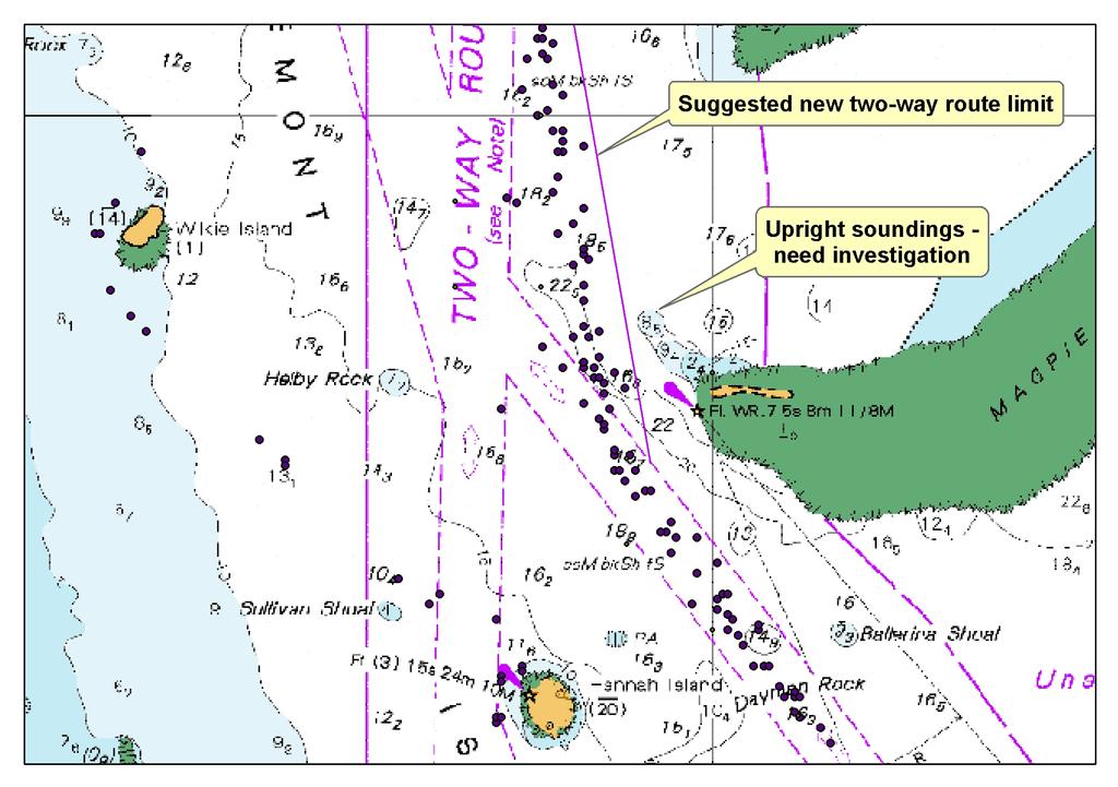
ROUTEING OF SHIPS, SHIP REPORTING AND RELATED MATTERS. New traffic separation schemes and two-way routes in Norra Kvarken
 E SUB-COMMITTEE ON SAFETY OF NAVIGATION 57th session Agenda item 3 NAV 57/3/7 11 March 2011 Original: ENGLISH ROUTEING OF SHIPS, SHIP REPORTING AND RELATED MATTERS New traffic separation schemes and two-way
D1.15 Draft Chapter 4 (e-navigation) for the 2018 Edition of the IALA NAVGUIDE
 for the 2018 Edition of the IALA NAVGUIDE") D1.15 Draft Chapter 4 (e-navigation) for the 2018 Edition of the IALA NAVGUIDE Project no. 636329 Project acronym: EfficienSea2 EFFICIENSEA2 efficient, safe and sustainable traffic at sea Funding scheme:
D1.15 Draft Chapter 4 (e-navigation) for the 2018 Edition of the IALA NAVGUIDE Project no. 636329 Project acronym: EfficienSea2 EFFICIENSEA2 efficient, safe and sustainable traffic at sea Funding scheme:
RESOLUTION A.659(16) adopted on 19 October 1989 PROVISION OF RADIO SERVICES FOR THE GLOBAL MARITIME DISTRESS AND SAFETY SYSTEM
 adopted on 19 October 1989 PROVISION OF RADIO SERVICES FOR THE GLOBAL MARITIME DISTRESS AND SAFETY SYSTEM") INTERNATIONAL MARITIME ORGANIZATION RESOLUTION A.659(16) adopted on 19 October 1989 A 16/Res.659 30 November 1989 Original: ENGLISH ASSEMBLY - 16th session Agenda item 10 IMO RESOLUTION A.659(16) adopted
INTERNATIONAL MARITIME ORGANIZATION RESOLUTION A.659(16) adopted on 19 October 1989 A 16/Res.659 30 November 1989 Original: ENGLISH ASSEMBLY - 16th session Agenda item 10 IMO RESOLUTION A.659(16) adopted
GUIDANCE ON THE COSPAS-SARSAT INTERNATIONAL 406 MHz BEACON REGISTRATION DATABASE
 E ALBERT EMBANKMENT LONDON SE1 7SR Telephone: +44 (0)20 7735 7611 Fax: +44 (0)20 7587 3210 GUIDANCE ON THE COSPAS-SARSAT INTERNATIONAL 406 MHz BEACON REGISTRATION DATABASE MSC.1/Circ.1210/Rev.1 21 November
ANNUAL OF NAVIGATION 19/2012/part 1
 ANNUAL OF NAVIGATION 19/2012/part 1 PAWEŁ BANYŚ, THORALF NOACK, STEFAN GEWIES German Aerospace Center (DLR), Institute of Communications and Navigation (IKN) ASSESSMENT OF AIS VESSEL POSITION REPORT UNDER
Project BONUS ESABALT
 Project BONUS ESABALT Economic and Non-Economic Feasibility Analysis dr Paweł Banaś Maritime University of Szczecin Content Assumptions 1. Analysis of navigational systems and devices 2. Expected ESABALT
Expanded use of Automatic Identification System (AIS) navigation technology in Vessel Traffic Services (VTS) B. J. Tetreault 1
 navigation technology in Vessel Traffic Services (VTS) B. J. Tetreault 1") Expanded use of Automatic Identification System (AIS) navigation technology in Vessel Traffic Services (VTS) B. J. Tetreault 1 1 (At time of writing) U. S. Coast Guard, Office of Shore Forces (CG-7413),
Expanded use of Automatic Identification System (AIS) navigation technology in Vessel Traffic Services (VTS) B. J. Tetreault 1 1 (At time of writing) U. S. Coast Guard, Office of Shore Forces (CG-7413),
ESSnet pilot AIS data. Anke Consten, Eleni Bisioti and Olav Grøndal (23 February 2017, Sofia)
") ESSnet pilot AIS data Anke Consten, Eleni Bisioti and Olav Grøndal (23 February 2017, Sofia) Overview 1. Introduction 2. Deliverables ESSnet pilot AIS data 3. Data access and handling 4. Quality of AIS
ESSnet pilot AIS data Anke Consten, Eleni Bisioti and Olav Grøndal (23 February 2017, Sofia) Overview 1. Introduction 2. Deliverables ESSnet pilot AIS data 3. Data access and handling 4. Quality of AIS
PMAR Piracy, Maritime Awareness & Risks
 PMAR Piracy, Maritime Awareness & Risks Maritime Situational Awareness for Counter-Piracy European Commission Joint Research Centre 13 June 2012 GeoMaritime, London 1 MSA for counter-piracy study Key elements
Radio Log Book. for Canadian Flag Vessels. 1 Master s Signature. Transports Canada. Transport Canada TP 13926E MARINE SAFETY
 Transport Canada MARINE SAFETY Transports Canada TP 13926E Radio Log Book for Canadian Flag Vessels Also for use on GMDSS exempted vessels Date Commenced Date Completed 1 Instructional Guide for Keeping
REVISED QUESTIONNAIRE ON SHORE-BASED FACILITIES FOR THE GLOBAL MARITIME DISTRESS AND SAFETY SYSTEM (GMDSS)
") E 4 ALBERT EMBANKMENT LONDON SE1 7SR Telephone: +44 (0)20 7735 7611 Fax: +44 (0)20 7587 3210 MSC.1/Circ.1382/Rev.2 24 June 2013 REVISED QUESTIONNAIRE ON SHORE-BASED FACILITIES FOR THE GLOBAL MARITIME DISTRESS
E 4 ALBERT EMBANKMENT LONDON SE1 7SR Telephone: +44 (0)20 7735 7611 Fax: +44 (0)20 7587 3210 MSC.1/Circ.1382/Rev.2 24 June 2013 REVISED QUESTIONNAIRE ON SHORE-BASED FACILITIES FOR THE GLOBAL MARITIME DISTRESS
IMO. Resolution A.977(24) Adopted on 1 December 2005 (Agenda item 9) SHIPS ROUTEING
 Adopted on 1 December 2005 (Agenda item 9) SHIPS ROUTEING") INTERNATIONAL MARITIME ORGANIZATION E IMO ASSEMBLY 24th session Agenda item 9 A 24/Res.977 27 January 2006 Original: ENGLISH Resolution A.977(24) Adopted on 1 December 2005 (Agenda item 9) SHIPS ROUTEING
INTERNATIONAL MARITIME ORGANIZATION E IMO ASSEMBLY 24th session Agenda item 9 A 24/Res.977 27 January 2006 Original: ENGLISH Resolution A.977(24) Adopted on 1 December 2005 (Agenda item 9) SHIPS ROUTEING
IHO Colours & Symbols Maintenance Working Group (C&SMWG) 15th Meeting, BSH, Rostock, Germany, 2-4 May 2005
 15th Meeting, BSH, Rostock, Germany, 2-4 May 2005") CSMWG15-INF2 IHO Colours & Symbols Maintenance Working Group (C&SMWG) 15th Meeting, BSH, Rostock, Germany, 2-4 May 2005 Ref: HA405/004/033-01 NOTE: this is an internal document of the UKHO and is supplied
CSMWG15-INF2 IHO Colours & Symbols Maintenance Working Group (C&SMWG) 15th Meeting, BSH, Rostock, Germany, 2-4 May 2005 Ref: HA405/004/033-01 NOTE: this is an internal document of the UKHO and is supplied
Space-Based AIS: Contributing to Global Safety and Security
 Space-Based AIS: Contributing to Global Safety and Security J.S. Cain 1, E. Meger 2, COM DEV Limited 155 Sheldon Ave, Cambridge, Ontario, Canada. Abstract Global trade continues to increase and today more
Class Update on Latest Ship to Ship Transfer Plan
 Class Update on Latest Ship to Ship Transfer Plan Binbin Li 17 May 2017 7th Forum on STS Best Practices - SNI, Singapore 2017 American Bureau of Shipping. All rights reserved Outline This presentation
GMDSS RADIO INSTALLATION
 Ship s name: N.R. Survey: GMDSS RADIO INSTALLATION (Res. A.1053(27)) INITIAL (Newconstruction) PERIODICAL RENEWAL Sea areas: A1 Methods of maintenance: Duplication of (Reg. IV/12-15) A1+A2 (Reg. IV/15)
D1.22 Information Plan to promote VHF Data Exchange System (VDES)
") D1.22 Information Plan to promote VHF Data Exchange System (VDES) Project no. 636329 Project acronym: EfficienSea2 e: EFFICIENSEA2 efficient, safe and sustainable traffic at sea Funding scheme: Innovation
D1.22 Information Plan to promote VHF Data Exchange System (VDES) Project no. 636329 Project acronym: EfficienSea2 e: EFFICIENSEA2 efficient, safe and sustainable traffic at sea Funding scheme: Innovation
IMO. Resolution A.954(23) Adopted on 5 December 2003 (Agenda item 17) PROPER USE OF VHF CHANNELS AT SEA
 Adopted on 5 December 2003 (Agenda item 17) PROPER USE OF VHF CHANNELS AT SEA") INTERNATIONAL MARITIME ORGANIZATION E IMO ASSEMBLY 23rd session Agenda item 17 A 23/Res.954 26 February 2004 Original: ENGLISH Resolution A.954(23) Adopted on 5 December 2003 (Agenda item 17) PROPER USE
INTERNATIONAL MARITIME ORGANIZATION E IMO ASSEMBLY 23rd session Agenda item 17 A 23/Res.954 26 February 2004 Original: ENGLISH Resolution A.954(23) Adopted on 5 December 2003 (Agenda item 17) PROPER USE
Loran C in Europe. 34 th Annual ILA Convention and Technical Symposium October 2005 Santa Barbara
 34 th Annual ILA Convention and Technical Symposium 17-19 October 2005 Santa Barbara Loran C in Europe Jacques MANCHARD Head of the Maritime Ads to Navigation Division (Phares et Balises) Ministry of Transport,
Korea s Strategy for e-navigation. SMART-Navigation. Presented by. Bu Young, Kim. 28 May Ministry of Oceans and Fisheries Republic of Korea
 Korea s Strategy for e-navigation SMART-Navigation Presented by Bu Young, Kim 28 May 2014 Ministry of Oceans and Fisheries Republic of Korea 1 2 3 4 5 6 1. SMART- Navigation? SMART-Navigation Korea s