E-Navigation: Opening the door to the future
|
|
|
- Clemence Stokes
- 5 years ago
- Views:
Transcription
1 International Association of Marine Aids to Navigation and Lighthouse Authorities E-Navigation: Opening the door to the future E-Navigation Underway North America November 2018 Secretary-General Francis ZACHARIAE
2 CONTENTS About IALA and the World-Wide Academy Challenges/Developments in the Maritime sector Future global infrastructure IALA Change of status

3 There are some challenges out there Source: MarineTraffic.com

4 Aids to Navigation IALA Constitution Art. 1 A device, system or service, external to vessels, designed and operated to enhance safe and efficient navigation of individual vessels and/or vessel traffic"
5 The IALA motto and principal aims "Successful voyages, sustainable planet" To harmonise standards for Aids to Navigation systems worldwide To facilitate the safe and efficient movement of shipping To enhance the protection of the marine environment
6 IALA Strategic Vision and Goals for 2026 Goal 1 Marine Aids to Navigation are developed and harmonized through international cooperation and the provision of standards. Goal 2 All coastal states have contributed to a sustainable and efficient global network of Marine Aids to Navigation through capacity building and the sharing of expertise.


7 Date: Insert / Header and footer Developed and Harmonized

8 Four types of Membership 85 National Members (Coastal States) 62 Associate Members 147 Industrial Members 47 Honorary Members
9 Publications Main result of the Committees work Standards which can be referred to directly in IMO and other international conventions and in national maritime laws. Recommendations which advise what should be done. Guidelines which advise how to implement the recommendations as best practice. Manuals which provide general reference materials (NAVGUIDE; MBS; VTS Guide; IALA Dictionary). Model courses which provide guidance on the training of VTS personnel, Aids to Navigation Managers and Aids to Navigation Technicians.
 Vessel Traffic Services (VTS) e-navigation Information Services and")
10 The Committees The Power House of IALA AtoN Requirements and Management (ARM) Engineering and Sustainability (ENG) Vessel Traffic Services (VTS) e-navigation Information Services and Communications (ENAV)

11 IALA Strategic Vision and Goals for 2026 Goal 1 Marine Aids to Navigation are developed and harmonized through international cooperation and the provision of standards. Goal 2 All coastal states have contributed to a sustainable and efficient global network of Marine Aids to Navigation through capacity building and the sharing of expertise.

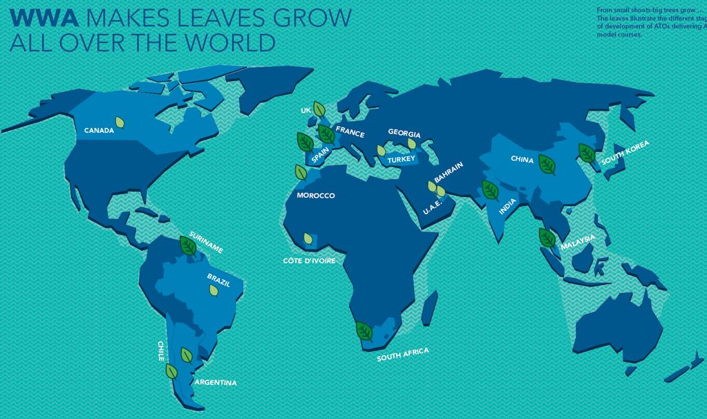
12 The IALA World-Wide Academy Inaugurated January 2012 Independently funded Integral part of IALA Education and training Capacity building, and Research & development 7-Nov-18

13 Maritime Management Quality 07/11/

14 Technical Needs Assessment Missions & States in Need 07/11/

15 States in need (2018) Priority 1-3 Reduced from 78 to 62 15
 Priority")
16 Those in need (still) Priority 1 2 3
17 07/11/
18 Delivering as one 07/11/
19 Challenges (Smarter Shipping) For the maritime sector and IALA
20 E-Navigation The definition ( ) E-navigation is defined as the harmonized collection, integration, exchange, presentation and analysis of marine information on board and ashore by electronic means to enhance berth to berth navigation and related services for safety and security at sea and protection of the marine environment.


21 Mind the Gab The Maritime domain into the digital age Technology Gab
22 The hype cycle 11/7/2018


23 The difficult balance Look out the window Autonomous navigation

24 2017 was the safest year in aviation history

25 (On-board navigation systems), Shore side vessel traffic information management and Ship-to-ship-, ship-to-shore and shore-to-shorecommunication infrastructure.

26 IALA and the future ships What about traditional Aids to Navigation?
27 IALA and the future ships Shore services Resilient Position, Navigation and Timing (PNT) Data Modelling Connectivity
28 Shore Services The 16 IMO SIP Maritime Services (digital) Aton related Services (draft guideline MS 17)
29 IALA and the future ships Shore services Resilient Position, Navigation and Timing (PNT) Data Modelling Connectivity

30 Increased dependence on automated systems combined with a decline in traditional skills gives rise to concern.
 R-mode (VDES, AIS, MF) Signals of Opportunity Radar positioning eloran (Europe has lost interest,")
31 Resilient Position, Navigation and Timing More GNSS systems available SBAS coverage increasing PNT services (draft guideline MS18) R-mode (VDES, AIS, MF) Signals of Opportunity Radar positioning eloran (Europe has lost interest, cost)
32 Date: Insert / Header and footer
33 IALA and the future ships Shore services Resilient Position, Navigation and Timing (PNT) Data Modelling Connectivity

34 Data Modeling S-100, S-200 Series Product Specifications Maritime Resource Names Data models for Maritime Services
 Data Modelling")
35 IALA and the future ships Shore services Resilient Position, Navigation and Timing (PNT) Data Modelling Connectivity
 LTE/5G Maritime Connectivity")
36 Connectivity VHF Data Exchange System (VDES) LTE/5G Maritime Connectivity Platforms
37 The Future From a Non-Governmental Organization to an Intergovernmental Organization
 and the System B (red color for the right hand side of the ship), were combined into one - the IALA Maritime Buoyage")
38 The Maritime Buoyage Agreement IALA A and IALA B During the IALA conference in November 1980 two navigation marking systems, i.e. the System A (red color for the left hand side of the ship) and the System B (red color for the right hand side of the ship), were combined into one - the IALA Maritime Buoyage System.

39 Advantages of IGO Status Increased international acceptance of Standards and existing Recommendations and Guidelines due to direct participation by Governments. Harmonization will be enhanced. Enhanced liaison with IMO and IHO with IALA as an equal partner. Synergies between this trinity of excellence will make more efficient use of the resources available. Headquarters agreement with host nation will provide additional financial, operational and human resource capabilities and reduce bureaucratic hurdles. fomembers.

40 Next Conference Istanbul March 2019
41 QUESTIONS? Feel free to contact the IALA Secretary-General Francis ZACHARIAE
IALA S WORK IN E-NAVIGATION. Michael Card
 IALA S WORK IN E-NAVIGATION Michael Card e-navigation origins The early work of IALA on e-navigation Multiple Initiatives EfficienSea 2 STM Validation IHO S-100 and IALA S-200 Smart Navigation VDES development
COMMUNICATIONS FOR MARITIME SAFETY AND EFFICIENCY. Francis Zachariae, Secretary-General, IALA
 COMMUNICATIONS FOR MARITIME SAFETY AND EFFICIENCY Francis Zachariae, Secretary-General, IALA IALA and its Purpose Non profit, international technical association established in 1957 Two Goals aimed at
E-NAVIGATION AND BEYOND
 E-NAVIGATION AND BEYOND The Work of IALA e-navigation Committee and Future CDR. Hideki NOGUCHI, Chair, IALA ENAV Committee e-navigation (ENAV) Committee Established in 2010 by merging R-NAV and AIS Committee
IALA and the physical& logical enavcommunicationframework
 IALA and the physical& logical enavcommunicationframework Ómar Frits Eriksson Director, Maritime Technology & Business Development at DMA Chair IALA e-nav Committee 21. February 2005 Important Window of
02 Issue. e-navigation News. GNSS Vulnerability. Dublin Bay Digital Diamond. e-navigation. Demonstrator Update International. e-navigation.
 CORPORATE SECURITY TEAMWORK EVENTS 02 Issue e-navigation News GNSS Vulnerability Dublin Bay Digital Diamond e-navigation Demonstrator Update International e-navigation update June 2014 www.cil.ie +353
POSITION ON THE DEVELOPMENT OF AtoN SERVICES
 POSITION ON THE DEVELOPMENT OF AtoN SERVICES P 2 DOCUMENT HISTORY 2017-12-15 First issue. Approved by Council at its 65 th session P 3 1. THE PURPOSE OF THIS DOCUMENT... 6 2. TRENDS AND DRIVERS OF STRATEGY
Development of VDES in IALA
 Development of VDES in IALA 2:nd Workshop on International Standardization of VDES Rolf Zetterberg Swedish Marime Administration Swedish Maritime Administration SMA SMA responsible for Fairways and AtoN
ESA IAP Blue Belt demonstration project:
 Page 1 ESA IAP Blue Belt demonstration project: supporting the European Maritime Safety Agency (EMSA) Blue Belt Project, by providing a service based on satellite based AIS data complementing the terrestrial
FOREWORD. IHO S-100 Working Group
 IHO International Hydrographic Organization KHOA Korea Hydrographic and Oceanographic Agency MUCH MORE THAN JUST NAUTICAL CHARTS IHO UNIVERSAL HYDROGRAPHIC data MODEL This document was produced with the
Technology evolution for future radiocommunication and navigation
 Technology evolution for future radiocommunication and navigation Frances Baskerville (Secretary General) Richard Doherty (Deputy Secretary General) CIRM Who we are and what we do What is CIRM? The Worldwide
e-navigation Progress and trends: the IHO perspective
 International Hydrographic Organization e-navigation Progress and trends: the IHO perspective Gilles Bessero Director, IHO International Hydrographic Organization Intergovernmental consultative and technical
D1.22 Information Plan to promote VHF Data Exchange System (VDES)
") D1.22 Information Plan to promote VHF Data Exchange System (VDES) Project no. 636329 Project acronym: EfficienSea2 e: EFFICIENSEA2 efficient, safe and sustainable traffic at sea Funding scheme: Innovation
D1.22 Information Plan to promote VHF Data Exchange System (VDES) Project no. 636329 Project acronym: EfficienSea2 e: EFFICIENSEA2 efficient, safe and sustainable traffic at sea Funding scheme: Innovation
GMDSS modernisation and e-navigation: spectrum needs
 ETSI Workshop "Future Evolution of Marine Communication", 7-8 November 2017, Sophia Antipolis, France GMDSS modernisation and e-navigation: spectrum needs Karlis Bogens BR Terrestrial Services Department
GMISS IALA and Maritime Information Sharing
 International Association of Marine Aids to Navigation and Lighthouse Authorities Association Internationale de Signalisation Maritime IALA and Maritime Information Sharing R.Adm. Jean-Charles Leclair
This document describes the IMO e-navigation strategy and recommends a Danish strategy for e-navigation and associated action plan.
 Strategy and action plan for e-navigation This document describes the IMO e-navigation strategy and recommends a Danish strategy for e-navigation and associated action plan. Our reference: JKJ/MAF Case
Demonstrator of a Data Processing Centre (DPC) for satellite-based AIS services
 for satellite-based AIS services") Page 1 Demonstrator of a Data Processing Centre (DPC) for satellite-based AIS services 19/20 April 2012 gfabritius@cls.fr Overview of the presentation Page 2 Introducing CLS Introducing AIS / SAT-AIS Scope
Page 1 Demonstrator of a Data Processing Centre (DPC) for satellite-based AIS services 19/20 April 2012 gfabritius@cls.fr Overview of the presentation Page 2 Introducing CLS Introducing AIS / SAT-AIS Scope
VHF Data Exchange System (VDES)
") VHF Data Exchange System (VDES) ETSI Workshop Future Evolution of Marine Communication 7-8 November 2017 Malcolm Lyman Marketing Manager CML Microcircuits UK With acknowledgments to the members of IALA
VHF Data Exchange System (VDES) ETSI Workshop Future Evolution of Marine Communication 7-8 November 2017 Malcolm Lyman Marketing Manager CML Microcircuits UK With acknowledgments to the members of IALA
L AGENCE NATIONALE DES FREQUENCES (ANFR) From Titanic to satellite from Morse to digital Entry in a new era for the maritime community
 From Titanic to satellite from Morse to digital Entry in a new era for the maritime community") L AGENCE NATIONALE DES FREQUENCES (ANFR) From Titanic to satellite from Morse to digital Entry in a new era for the maritime community ITU regional seminar 6-8 June 2018 St-Petersburg, Russian Federation
L AGENCE NATIONALE DES FREQUENCES (ANFR) From Titanic to satellite from Morse to digital Entry in a new era for the maritime community ITU regional seminar 6-8 June 2018 St-Petersburg, Russian Federation
NAVGUIDE 2014 SEVENTH EDITION
 I N T E R N AT I O N A L A S S O C I AT I O N O F M A R I N E A I D S T O N AV I G AT I O N A N D L I G H T H O U S E A U T H O R I T I E S NAVGUIDE A I D S T O N AV I G AT I O N M A N U A L 2014 SEVENTH
Challenges and opportunities in the e-navigation Development. Actual projects.
 Challenges and opportunities in the e-navigation Development. Actual projects. John Erik Hagen, Regional Director Oslo, September 2018 What is e-navigation? Efficient transfer of marine information and
Market strategy update in Maritime segment. This presentation can be interpreted only together with the oral comments accompanying it
 Market strategy update in Maritime segment This presentation can be interpreted only together with the oral comments accompanying it 2 Market sub-segments and applications Recreational navigation: GNSS
Korea s Strategy for e-navigation. SMART-Navigation. Presented by. Bu Young, Kim. 28 May Ministry of Oceans and Fisheries Republic of Korea
 Korea s Strategy for e-navigation SMART-Navigation Presented by Bu Young, Kim 28 May 2014 Ministry of Oceans and Fisheries Republic of Korea 1 2 3 4 5 6 1. SMART- Navigation? SMART-Navigation Korea s
TECHNICAL COMMITTEE 80: MARITIME NAVIGATION AND RADIOCOMMUNICATION EQUIPMENT AND SYSTEMS INTERNATIONAL ELECTROTECHNICAL COMMISSION
 TECHNICAL COMMITTEE 80: MARITIME NAVIGATION AND RADIOCOMMUNICATION EQUIPMENT AND SYSTEMS INTERNATIONAL ELECTROTECHNICAL COMMISSION IEC TECHNICAL COMMITTEE 80: MARITIME NAVIGATION AND RADIOCOMMUNICATION
New Funding Opportunities to Support Safety of Navigation: EGNOS and Galileo
 New Funding Opportunities to Support Safety of Navigation: EGNOS and Galileo e-navigation Underway 31 January-2 February 2017 GSA 2016 The European GNSS Agency (GSA) today: Staff: about 145 Nationalities:
MONTHLY MEETING REPORTS JANUARY 2018
 8 th e-navigation Underway International Conference MS Pearl Seaways, at Sea, 24 to 26 January Contribution to the IHO Work Programme 2018 Task 2.1.6.1 E navigation Underway International 2018 The 8 th
IALA World Wide Radio Navigation Plan
 C54/9.2/14a International Association of Marine Aids to Navigation and Lighthouse Authorities AISM Association Internationale de Signalisation Maritime IALA IALA World Wide Radio Navigation Plan Edition
The Automatic Identification System operating jointly with radar as the aid to navigation
 Scientific Journals Maritime University of Szczecin Zeszyty Naukowe Akademia Morska w Szczecinie 2013, 36(108) z. 1 pp. 156 161 2013, 36(108) z. 1 s. 156 161 ISSN 1733-8670 The Automatic Identification
Trials of e-radar/e-raconpositioning System at Singapore port
 e-navigation Underway 2017 Trials of e-radar/e-raconpositioning System at Singapore port 2017.2.1 Takuo KASHIWA Furuno Electric Co., Ltd. Agenda Concept of Radar Positioning Singapore Trial Overview Trial
Digital broadcasting systems under development within ITU-R of interest for the maritime community
 Digital broadcasting systems under development within ITU-R of interest for the maritime community Christian RISSONE ANFR rissone@anfr.fr IHO, WWNWS 5 Monaco, 2 nd October 2013 1 Background for the 500
RF Monitoring Service Profile Based on AIS Binary Message
 , pp.55-59 http://dx.doi.org/10.14257/astl.2015.108.13 RF Monitoring Service Profile Based on AIS Binary Message Soyoung Hwang Catholic University of Pusan, 609-757 Busan, South Korea soyoung@cup.ac.kr
This circular summarizes the various important aspects of the LRIT system with a view to enabling companies to ensure compliance in a timely manner.
 Luxembourg, 29/10/2008 CIRCULAR CAM 02/2008 N/Réf. : AH/63353 Subject : Long-Range Identification and Tracking of Ships (LRIT) To : All ship owners, ship operators and designated persons of Luxembourg
DEVELOPMENT OF A DEFINITION FOR MSPS AND CONSIDERATION FOR THE HARMONIZATION OF THE FORMAT AND STRUCTURE OF MSPS
 INTERNATIONAL HYDROGRAPHIC ORGANIZATION E IMO/IHO HARMONIZATION GROUP ON DATA MODELLING Agenda item 5 15 September 2017 ENGLISH ONLY DEVELOPMENT OF A DEFINITION FOR MSPS AND CONSIDERATION FOR THE HARMONIZATION
Technical Programme. Waypoints beyond the Strategy Implementation Plan
 Technical Programme Waypoints beyond the Strategy Implementation Plan Voyage plan Copenhagen - Oslo - Copenhagen 28-30 January 2014 For the fourth time the international e-navigation community will gather
Integration of AIS functionalities
 Integration of AIS functionalities by John O. Klepsvik FARGIS 05 March 01, 2005 WORLD CLASS through people, technology and dedication WORLD CLASS through people, technology and dedication KONGSBERG March
European Radio Navigation Plan. Gilles LEQUEUX, European Commission Policy Development and Strategies
 European Radio Navigation Plan Gilles LEQUEUX, European Commission Policy Development and Strategies CONTEXT - BENEFITS Space Strategy for Europe Introduction of EGNSS in EU sectoral policies Better strategic
MARINE NAVIGATION PLAN 2016 to 2030
 General Lighthouse Authorities The United Kingdom and Ireland The General Lighthouse Authorities Marine Navigation Plan has been undertaken by: Commissioners of Irish Lights Northern Lighthouse Board Trinity
IHO Colours & Symbols Maintenance Working Group (C&SMWG) 15th Meeting, BSH, Rostock, Germany, 2-4 May 2005
 15th Meeting, BSH, Rostock, Germany, 2-4 May 2005") CSMWG15-INF2 IHO Colours & Symbols Maintenance Working Group (C&SMWG) 15th Meeting, BSH, Rostock, Germany, 2-4 May 2005 Ref: HA405/004/033-01 NOTE: this is an internal document of the UKHO and is supplied
CSMWG15-INF2 IHO Colours & Symbols Maintenance Working Group (C&SMWG) 15th Meeting, BSH, Rostock, Germany, 2-4 May 2005 Ref: HA405/004/033-01 NOTE: this is an internal document of the UKHO and is supplied
Using AIS to identify and investigate ferry accidents
 Using AIS to identify and investigate ferry accidents David Hewson Antenna Network Manager Genscape Vesseltracker info@genscape.com DE: +49 (0) 97 07 86 10 EU: +31 20 524 4089 Background Vesseltracker
GUIDANCE FOR THE PRESENTATION AND DISPLAY OF AIS APPLICATION-SPECIFIC MESSAGES INFORMATION
 E 4 ALBERT EMBANKMENT LONDON SE1 7SR Telephone: +44 (0)20 7735 7611 Fax: +44 (0)20 7587 3210 Ref. T2-OSS/2.7.1 SN.1/Circ.290 2 June 2010 GUIDANCE FOR THE PRESENTATION AND DISPLAY OF AIS APPLICATION-SPECIFIC
Irish Lights Strategy Safe Seas Connected Coasts
 Irish Lights Strategy 2018 2023 Safe Seas Connected Coasts Risk response and shared areas for the General Lighthouse Authorities of Ireland, Scotland, England and Wales Cover Image: Crown Copyright and/or
Satellite technology to prevent and respond in cases of maritime accidents
 United Nations International Conference on Space-based Technologies for Disaster Management "Disaster risk identification, assessment and monitoring" 23-25 October 2013, Beijing, China. Satellite technology
UNIVERSAL AUTOMATIC IDENTIFICATION SYSTEM
 IALA GUIDELINES ON THE UNIVERSAL AUTOMATIC IDENTIFICATION SYSTEM (AIS) Volume 1, Part II Technical Issues Edition 1.1 December 2002 IALA / AISM 20ter rue Schnapper 78100 Saint Germain en Laye France Tel
GPS Jamming and its impact on maritime navigation
 GPS Jamming and its impact on maritime navigation Dr Alan Grant Research and Development - Special Interest Group 10 th May 2010 Use of GPS in the maritime sector GPS has become the normal means for maritime
Visual Aids to Navigation Plan. Visual AtoN. General Lighthouse Authorities The United Kingdom and Ireland
 General Lighthouse Authorities The United Kingdom and Ireland Visual Aids to Navigation Plan Visual Lighthouses Beacons ~ Major Floating Aids ~ Buoys ~ Day Marks Glossary of Terms CIE CIL DfT DTTAS ECDIS
Maritime Situational Awareness Will e-navigation Lead to Perfect Alarming?
 Maritime Situational Awareness Will e-navigation Lead to Perfect Alarming? ESABALT SIMSA 2016 Solutions for Maritime Situational Awareness HELSINKI, FINLAND 12 th February 2016 World Maritime University
Maritime Electronics Supporting Unmanned Vessels
 EU-Japan Policy Workshop Maritime Electronics Supporting Unmanned Vessels November 11 th, 2016 TAKUO KASHIWA, Ph.D Furuno Electric Co., Ltd. Agenda Positioning Technologies for Vessel s position Technologies
GALILEO Research and Development Activities. Second Call. Area 1A. Statement of Work
 GALILEO Research and Development Activities Second Call Area 1A GNSS Introduction in the Maritime Sector Statement of Work Rue du Luxembourg, 3 B 1000 Brussels Tel +32 2 507 80 00 Fax +32 2 507 80 01 www.galileoju.com
Maritime Communications
 Maritime Communications Strategic Sectorial Spectrum Needs Conferência sobre Gestão do Espectro: Perspectivas, Desafios e Estratégias Lisboa, 20 de setembro de 2013 RSPG Work Programme 2012 and Beyond
Technical Programme The realisation of the Maritime Service Portfolios
 Technical Programme The realisation of the Maritime Service Portfolios Copenhagen Oslo Copenhagen 24 th 26 th January 2018 1 Day One 24 th January 2018 11:00 Check in and welcome in the terminal 12:00
IHO S-100 FRAMEWORK - BASELINE STANDARD FOR E- NAVIGATION MARITIME SERVICES
 UNDERWAY (24 26 January 2018) IHO S-100 FRAMEWORK - BASELINE STANDARD FOR E- NAVIGATION MARITIME SERVICES Abri Kampfer Director, IHO Copenhagen, Denmark (24 26 January 2018) What is the?. intergovernmental
All CIRM Members. From: Richard Doherty, Chief Technical Officer. Report of e-navigation Underway 2015 Copenhagen/Oslo January 2015
 202 Lambeth Road London SE1 7SJ Circular 03/15 9 th February 2015 To: All CIRM Members From: Richard Doherty, Chief Technical Officer Report of e-navigation Underway 2015 Copenhagen/Oslo 27-29 January
RESOLUTION MSC.278(85) (adopted on 1 December 2008) ADOPTION OF THE NEW MANDATORY SHIP REPORTING SYSTEM "OFF THE COAST OF PORTUGAL - COPREP"
 (adopted on 1 December 2008) ADOPTION OF THE NEW MANDATORY SHIP REPORTING SYSTEM OFF THE COAST OF PORTUGAL - COPREP") MSC 85/26/Add.1 RESOLUTION MSC.278(85) SYSTEM OFF THE COAST OF PORTUGAL COPREP THE MARITIME SAFETY COMMITTEE, RECALLING Article 28 of the Convention on the International Maritime Organization concerning
MSC 85/26/Add.1 RESOLUTION MSC.278(85) SYSTEM OFF THE COAST OF PORTUGAL COPREP THE MARITIME SAFETY COMMITTEE, RECALLING Article 28 of the Convention on the International Maritime Organization concerning
Expanded use of Automatic Identification System (AIS) navigation technology in Vessel Traffic Services (VTS) B. J. Tetreault 1
 navigation technology in Vessel Traffic Services (VTS) B. J. Tetreault 1") Expanded use of Automatic Identification System (AIS) navigation technology in Vessel Traffic Services (VTS) B. J. Tetreault 1 1 (At time of writing) U. S. Coast Guard, Office of Shore Forces (CG-7413),
Expanded use of Automatic Identification System (AIS) navigation technology in Vessel Traffic Services (VTS) B. J. Tetreault 1 1 (At time of writing) U. S. Coast Guard, Office of Shore Forces (CG-7413),
Plausibility analysis of navigation related AIS parameter based on time series
 Plausibility analysis of navigation related AIS parameter based on time series Frank Heymann, Thoralf Noack, Paweł Banyś Deutsches Zentrum für Luft und Raumfahrt ev, Neustrelitz, Germany email: frank.heymann@dlr.de
Government Agency Perspectives & Initiatives Canadian Coast Guard Laurent Tardif, Director, Safe Shipping
 Unclassified Government Agency Perspectives & Initiatives Canadian Coast Guard Laurent Tardif, Director, Safe Shipping Mariner s Workshop January 23, 2019 1 Overview 1 Context 2 Marine Fees 3 4 5 Update
Bill Kautz U.S. Coast Guard Telecommunications Manager IALA e NAV Committee AIS/COMMS WG Vice Chair
 Bill Kautz U.S. Coast Guard Telecommunications Manager IALA e NAV Committee AIS/COMMS WG Vice Chair Discussion WRC 12 Results WRC 15 Agenda Item 1.16 Resolution 360 (WRC 12) ITU R WP5B VHF Data Exchange
United States Coast Guard Office of Navigation Systems
 United States Coast Guard Office of Navigation Systems Future of Navigation Initiatives & Operations R. David Lewald Program Analyst Navigation Systems Office of Navigation Systems U.S. Coast Guard Washington,
Satellite services for maritime security
 Satellite services for ITS-T Sophia Antipolis 6 June 2007 Jean-Pierre Cauzac, CLS - Collecte Localisation Satellites 35 Are the seas becoming more dangerous? IMB report 2006 shows improvement: 239 piracy
Frank Heymann 1.
 Plausibility analysis of navigation related AIS parameter based on time series Frank Heymann 1 1 Deutsches Zentrum für Luft und Raumfahrt ev, Neustrelitz, Germany email: frank.heymann@dlr.de In this paper
MARITIME RADIO SYSTEMS FOR DISTRESS ALERTING
 Journal of KONES Powertrain and Transport, Vol. 25, No. 1 2018 MARITIME RADIO SYSTEMS FOR DISTRESS ALERTING Karol Korcz Gdynia Maritime University Department of Marine Telecommunication Morska Street 81-87,
e-navigation: A Showcase of Progress and Trends Copenhagen Oslo Copenhagen January 31st - February 2nd
 e-navigation: A Showcase of Progress and Trends Copenhagen Oslo Copenhagen January 31st - February 2nd Day 1 Welcome address Omar Frits Eriksson, Dean IALA World-Wide Academy, Conference chair Opening
A new Modular and Open Concept for the Maritime Integrated PNT System
 A new Modular and Open Concept for the Maritime Integrated PNT System T. Noack German Aerospace Center Institute of Communications and Navigation www.dlr.de Chart 2 MTS-2012 Maritime Integrated PNT Unit
Absolute Positioning by Radar
 Absolute Positioning by Radar Dr Nick Ward, Research Director General Lighthouse Authorities of UK & Ireland 14th IAIN Congress 2012, 01-03 October, 2012 - Cairo, Egypt Seamless Navigation (Challenges
GUIDELINES ON THE DESIGN AND USE OF PORTABLE PILOT UNITS INTERNATIONAL MARITIME PILOTS ASSOCIATION
 GUIDELINES ON THE DESIGN AND USE OF PORTABLE PILOT UNITS INTERNATIONAL MARITIME PILOTS ASSOCIATION WITH TECHNICAL INPUT FROM Comité International Radio-Maritime (CIRM) 2 FOREWORD With the increasing use
Automatic identification system VHF data link loading
 Report ITU-R M.2287-0 (12/2013) Automatic identification system VHF data link loading M Series Mobile, radiodetermination, amateur and related satellite services ii Rep. ITU-R M.2287-0 Foreword The role
IALA Guideline No. XXXX. The establishment of AIS as an Aid to Navigation. Edition 1.3. [Date] Working vs / Working 7.
![IALA Guideline No. XXXX. The establishment of AIS as an Aid to Navigation. Edition 1.3. [Date] Working vs / Working 7.](/thumbs/74/71399138.jpg "IALA Guideline No. XXXX. The establishment of AIS as an Aid to Navigation. Edition 1.3. [Date] Working vs / Working 7.") ANM12/Output/10 International Association of Marine Aids to Navigation and Lighthouse Authorities AISM Association of Internationale de Signalisation Maritime IALA IALA Guideline No. XXXX On The establishment
ANM12/Output/10 International Association of Marine Aids to Navigation and Lighthouse Authorities AISM Association of Internationale de Signalisation Maritime IALA IALA Guideline No. XXXX On The establishment
A guideline for establishing feature and symbol standard management system for national HOs
 A guideline for establishing feature and symbol standard management system for national HOs Joint 26th TSMAD and 5th DIPWG Meeting Silver Spring, Maryland, USA(10-14 June 2013) Republic of Korea (ROK)
THE BLUEMED INITIATIVE AND ITS STRATEGIC RESEARCH AGENDA
 THE BLUEMED INITIATIVE AND ITS STRATEGIC RESEARCH AGENDA Pierpaolo Campostrini CORILA Managing Director & IT Delegation Horizon2020 SC2 committee & ExCom of the Management Board of JPI Oceans BLUEMED ad
Joint Announcement. no Official languages in area managed by the Common Nautical Authority
 Joint Announcement no. 04 2011 Official languages in area managed by the Common Nautical Authority The Dutch Governmental Harbour Master for the Western Scheldt and the Flemish Administrator General of
INTERNATIONAL STANDARD
 INTERNATIONAL STANDARD IEC 62320-1 First edition 2007-02 Maritime navigation and radiocommunication equipment and systems Automatic identification system (AIS) Part 1: AIS Base Stations Minimum operational
INTERNATIONAL STANDARD
 INTERNATIONAL STANDARD IEC 61174 Second edition 2001-10 Maritime navigation and radiocommunication equipment and systems Electronic chart display and information system (ECDIS) Operational and performance
Fisheries and Marine Resources (Automatic Identification System) Regulations
 Regulations") Fisheries and Marine Resources (Automatic Identification System) Regulations 2016 GN No. 116 of 2016 Government Gazette of Mauritius No. 47of 28 May 2016 THE FISHERIES AND MARINE RESOURCES ACT Regulations
Fisheries and Marine Resources (Automatic Identification System) Regulations 2016 GN No. 116 of 2016 Government Gazette of Mauritius No. 47of 28 May 2016 THE FISHERIES AND MARINE RESOURCES ACT Regulations
ITU 'Young ICT Leaders Forum 2015' Maritime digital communication for e-navigation (WED) Daeho Kim ETRI
 Daeho Kim ETRI") ITU 'Young ICT Leaders Forum 2015' Maritime digital communication for e-navigation 2015. 12. 9. (WED) Daeho Kim ETRI 2 GMDSS GMDSS Communication 3 e-navigation Roadmap e-nav Proposal Adoption approval(imo)
ITU 'Young ICT Leaders Forum 2015' Maritime digital communication for e-navigation 2015. 12. 9. (WED) Daeho Kim ETRI 2 GMDSS GMDSS Communication 3 e-navigation Roadmap e-nav Proposal Adoption approval(imo)
DRAFT ASSEMBLY RESOLUTION A. (26)
") DRAFT ASSEMBLY RESOLUTION A. (26) PROMULGATION OF MARITIME SAFETY INFORMATION The ASSEMBLY, RECALLING Article 15(j) of the Convention on the International Maritime Organization concerning the functions
DRAFT ASSEMBLY RESOLUTION A. (26) PROMULGATION OF MARITIME SAFETY INFORMATION The ASSEMBLY, RECALLING Article 15(j) of the Convention on the International Maritime Organization concerning the functions
Capability Statement VTS Simulator MSCN
 Capability Statement VTS Simulator MSCN Version 9.3, July 2006 M A R I N P.O. Box 28 6700 AA Wageningen The Netherlands T +31 317 49 39 11 F +31 317 49 32 45 E info@marin.nl I www.marin.nl Capability Statement
COMMUNICATION SYSTEMS FOR SAFETY AND SECURITY OF SHIPS
 Journal of KONES Powertrain and Transport, Vol. 23, No. 1 2016 COMMUNICATION SYSTEMS FOR SAFETY AND SECURITY OF SHIPS Karol Korcz Gdynia Maritime University, Department of Marine Telecommunication Morska
INTERNATIONAL STANDARD
 INTERNATIONAL STANDARD IEC 61993-2 First edition 2001-12 Maritime navigation and radiocommunication equipment and systems Automatic identification systems (AIS) Part 2: Class A shipborne equipment of the
JCG GMDSS Symposium NAVDAT : Navigational Data
 JCG GMDSS Symposium 2013 NAVDAT : Navigational Data - System Presentation - Pascal OLIVIER NAVDAT Presentation Page 1/35 From analog to digital in maritime radio communications The current analog radio
... Salient Ocean Issues that have arisen during 2002
 ... As reported in paragraph 62 of the resolution Oceans and the law of the seas, we are especially pleased with the focus for this meeting, given that protecting vulnerable marine ecosystems and safety
MARITIME COMMUNICATIONS - VHF EXCHANGES
 Unit 36a MARITIME COMMUNICATIONS - VHF EXCHANGES Any conversation at sea, i.e. a ship-to -ship, ship-to-shore or shoreto-ship exchange, consists of the following stages: 1. MAKING CONTACT 2. EXCHANGE OF
International Maritime Organization DRAFT IMO POSITION ON WRC-19 AGENDA ITEMS CONCERNING MATTERS RELATING TO MARITIME SERVICES
 2 nd ITU INTER-REGIONAL WORKSHOP ON WRC-19 PREPARATION Geneva, 20 22 November 2018 Document 12 November 2018 English only International Maritime Organization DRAFT IMO POSITION ON WRC-19 AGENDA ITEMS CONCERNING
The Future for the AIS AtoN. Michael Card Zeni Lite Buoy Co., Ltd., Japan
 The Future for the AIS AtoN Michael Card Zeni Lite Buoy Co., Ltd., Japan History Early work in USA and Europe Not compatible with UAIS First UAIS AIS AtoN was Akari-400 Launched at IALA Sydney, 8 years
INFORMATION PAPER ON AIS AIDS TO NAVIGATION REPORT MESSAGES IN INLAND WATERWAYS
 INFORMATION PAPER ON AIS AIDS TO NAVIGATION REPORT MESSAGES IN INLAND WATERWAYS Edition 1.1 Version: 09-05-2017 Author: Inland ECDIS Expert Group and Vessel Tracking and Tracing Expert Group VTT / IECDIS
European GNSS Applications in H2020
 European GNSS Applications in H2020 Countdown to H2020 12.12.2013, Brussels Carmen Aguilera European GNSS Agency Agenda European GNSS Agency EU-GNSS market potential FP7- experience and results H2020 opportunities
The Role of Automatic Identification System (AIS) in Enhancing Vessel Traffic Management By Capt. Ehab Ibrahim Etman
 in Enhancing Vessel Traffic Management By Capt. Ehab Ibrahim Etman") The Role of Automatic Identification System (AIS) in Enhancing Vessel Traffic Management By Capt. Ehab Ibrahim Etman Abstract The International Maritime Organization (IMO) adopted a new requirement for
The Role of Automatic Identification System (AIS) in Enhancing Vessel Traffic Management By Capt. Ehab Ibrahim Etman Abstract The International Maritime Organization (IMO) adopted a new requirement for
Examples of needed amendments to STCW Code. Zbigniew Szozda. Report
 Improving the Safety at Sea through Maritime Education and Training Examples of needed amendments to STCW Code Zbigniew Szozda Maritime University of Szczecin, Poland Chairman, IMO Sub-committee on Stability
Draft performance standards for shipborne "BeiDou" BDS receiver equipment
 IMO NAV 59 Summary Report Introduction The 59th session of the IMO Sub-Committee on Safety of Navigation (NAV 59) was held from 2nd to 6th September 2013, at the IMO headquarters in London. This briefing
Committee on Development and Intellectual Property (CDIP)
") E CDIP/10/13 ORIGINAL: ENGLISH DATE: OCTOBER 5, 2012 Committee on Development and Intellectual Property (CDIP) Tenth Session Geneva, November 12 to 16, 2012 DEVELOPING TOOLS FOR ACCESS TO PATENT INFORMATION
E CDIP/10/13 ORIGINAL: ENGLISH DATE: OCTOBER 5, 2012 Committee on Development and Intellectual Property (CDIP) Tenth Session Geneva, November 12 to 16, 2012 DEVELOPING TOOLS FOR ACCESS TO PATENT INFORMATION
Evaluation of Strategic Area: Marine and Maritime Research. 1) Strategic Area Concept
 Strategic Area Concept") Evaluation of Strategic Area: Marine and Maritime Research 1) Strategic Area Concept Three quarters of our planet s surface consists of water. Our seas and oceans constitute a major resource for mankind,
Evaluation of Strategic Area: Marine and Maritime Research 1) Strategic Area Concept Three quarters of our planet s surface consists of water. Our seas and oceans constitute a major resource for mankind,
ITU matters, including Radiocommunication ITU-R Study Group matters (Agenda item 5)
") IMO NAV 59 Agenda preview Introduction The 59th session of the IMO Sub-Committee on Safety of Navigation (NAV 59) will be held from 2nd to 6th September 2013, at the IMO headquarters in London. This briefing
IMO NAV 59 Agenda preview Introduction The 59th session of the IMO Sub-Committee on Safety of Navigation (NAV 59) will be held from 2nd to 6th September 2013, at the IMO headquarters in London. This briefing
MARITIME COMMUNICATIONS IDENTIFYING CURRENT AND FUTURE SATELLITE REQUIREMENTS & TECHNOLOGIES
 MARITIME COMMUNICATIONS IDENTIFYING CURRENT AND FUTURE SATELLITE REQUIREMENTS & TECHNOLOGIES Simon Plass and Federico Clazzer Institute of Communications and Navigation, German Aerospace Center (DLR),
International e-navigation Underway 2016 Conference Report REPORT
 International e-navigation Underway 2016 Conference Report REPORT e-navigation UNDERWAY INTERNATIONAL 2018 CONFERENCE REPORT Executive Summary The eight e-navigation Underway International conference was
Ocean Observations Erik Buch EuroGOOS chair
 EB1 EB2 Ocean Observations Erik Buch EuroGOOS chair 15-07-2015 EuroGOOS AISBL eurogoos@eurogoos.eu - http://www.eurogoos.eu 1 Slide 1 EB1 Erik Buch, 2/26/2014 EB2 Erik Buch, 2/26/2014 Maritime activities
Alternative Positioning, Navigation, Timing, and Data for Korea and the World
 Shared interest in a more productive tomorrow. Alternative Positioning, Navigation, Timing, and Data for Korea and the World Prepared by: Mr. Charles Schue, President & CEO ILA40 / KIN November 17, 2011
ROUTEING OF SHIPS, SHIP REPORTING AND RELATED MATTERS. New traffic separation schemes and two-way routes in Norra Kvarken
 E SUB-COMMITTEE ON SAFETY OF NAVIGATION 57th session Agenda item 3 NAV 57/3/7 11 March 2011 Original: ENGLISH ROUTEING OF SHIPS, SHIP REPORTING AND RELATED MATTERS New traffic separation schemes and two-way
International Maritime Organization
 1st ITU Inter-regional Workshop on WRC-19 Preparation Geneva, 21-22 November 2017 Received: 9 November 2017 Document 10 November 2017 English only International Maritime Organization DRAFT IMO POSITION
PROTECTING GPS/GNSS-RELIANT MILITARY SYSTEMS
 PROTECTING GPS/GNSS-RELIANT MILITARY SYSTEMS John Fischer VP Advanced R&D Jon Sinden Product Manager, Rugged PNT 6/21/2018 ABOUT OROLIA A world leader in assured positioning, navigation and timing (PNT)
IMO ACTIVITIES AFFECTING HSSC
 HSSC1-04.2A rev3 1 st HSSC MEETING Singapore, 22-24 October 2009 Paper for Consideration by HSSC IMO ACTIVITIES AFFECTING HSSC Submitted by: Executive Summary: Related Documents: IHB This paper summarizes
VDES: Next Generation AIS in the Review & Modernization of the GMDSS
 JCG GMDSS Symposium VDES: Next Generation AIS in the Review & Modernization of the GMDSS 19 November 2013 VDES: Next Generation AIS Contents 1. Present situation & Problems GMDSS & AIS 2. Future: from
18th IALA Conference
 International Association of Marine Aids to Navigation and Lighthouse Authorities REPORT 18th IALA Conference AISM Association Internationale de Signalisation Maritime IALA Aids to Navigation Knowledge