RADARSAT-1: An End-of-Mission Review of the Imaging and Calibration Performance of a Magnificent Canadian Instrument
|
|
|
- Emery Harper
- 5 years ago
- Views:
Transcription

1 RADARSAT-1: An End-of-Mission Review of the Imaging and Calibration Performance of a Magnificent Canadian Instrument S. Cote, S. Srivastava Canadian Space Agency S. Muir Calian Technologies Ltd 1


2 RADARSAT-1 Canada's first operational EO satellite Launched November Operational April 1996 HH, C-Band, right-looking Mission Lifetime: 5.25 yrs Actual Lifetime: 17.3 yrs Sun-synchronous, Dawn Dusk LEO Altitude: 798 km Period: minutes Repeat Cycle: 24 days Orbits per day: 14 2
3 Outline Calibration Activities Closeout Image Quality (point target) review Radiometric performance review Internal calibration history Conclusion 3
4 Recent events affecting the spacecraft February 6, 2013: First occurrence of an anomaly related to a power degradation of the low power transmitter (LPT) induced by failure to load chirp information needed for imagery. March 5: After several occurrences (22) of LPT anomaly, decision was taken to reconfigure the payload in order to use the redundant unit. March 6: Redundant LPT was successfully activated. This did not immediately stop the anomaly from occurring: two other instances happened less than 24 hours after reconfiguration. March 7-8: Images acquired with the redundant LPT were of good general IQ. Plan had begun to assess the calibration and imaging performance of the reconfigured payload using point target and distributed target scenes. March 9-26: No anomalies, nominal payload imaging. March 27-28: Five planned outages for battery reconditioning were executed during that period (routine outages performed each spring). Spacecraft was back to nominal after procedures. March 29, between 06:05 and 07:28 UTC: Last complete communication with spacecraft: RADARSAT-1 was assumed to be in safe-hold mode. May


5 Closeout of IQ and Calibration Operations Nominal IQ and Calibration operations have ceased shortly after final loss of communication with the spacecraft (29 Mar 2013): Acquisition planning, image analysis, trend analysis, transponder scheduling; Longer-term projects such as comparative radiometric level validations with R2, and prototyping of new beam pattern corrections (payload update 33); Close-out and final issuance of cal-val reports, procedures, databases, SW. Over the last couple of years, the Calibration Operations had already begun consolidating its activities for RADARSAT-1: Decommissioning of Resolute and Prince Albert transponders; Upgrade of Fredericton transponder and re-deployment in St Hubert. 5

6 Last Boreal Forest scene acquired Standard 1 6


7 Last transponder scene acquired Extended High 6 Transponder response TT&C antenna reflection CSA 7
8 IQ Performance: Impulse Response Indicators Range and Azimuth 3 db Impulse Response Width (30, 17.28, MHz) Range IRW (m) MHz MHz MHz Azimuth IRW (m) MHz MHz MHz 5 5 2D Integrated Side Lobe Ratio Range and Azimuth Peak Side Lobe Ratio D ISLR (db) PSLR (db) Azimuth Range Specification 8
9 Geolocation accuracy After last range bias adjustment performed in Jan. 2007, directional location error bias was on average: +0.8 m. Average of absolute location error since Jan. 2007: 60 m. Requirement: 750 m. Absolute Location Error (m) Azimuth Range 2D Beam Absolute Location Accuracy (m) (predicted orbit) Wide 60 Standard 52 Fine 56 Low Incidence 72 High Incidence 56 Geometric distortion since Jan. 2007: 39.0 m (design goal: < 40 m) Based on Ottawa scenes with transponder and Gatineau antenna. 9
10 Image footprint offset relative to SPA (Swath Planning Application) Northern latitudes Boreal Forest and transponder sites Image Footprint Offset relative to SPA Swaths (km, East positive) Jul-98 Jul-99 Manoeuvre overburn anomaly Apr Jul-00 Jul-01 Jul-02 Jul-03 Jul-04 SPA orbit model update, Dec Jul-05 Jul-06 Jul-07 Collision avoidance manoeuvre Aug Jul-08 Jul-09 Jul-10 Jul-11 F S Jul-12 At end of mission, the centre of a delivered product was around 4 km to the West of the intended swath in SPA at the latitude of the calibration sites. Current trend towards a 0 km offset was part of a long-term oscillation between the simplified orbit model of the SPA and the actual RADARSAT-1 orbit propagator. Image footprint offset slowly continued its decrease of 1 km/year, which would have led to a 0 km offset by Aug
11 Radiometric stability from transponder data DGCF, 2000-present, from all transponders DGCF (db) = RCS true - RCS est 11 DGCF (db) Ice buildup on antennas (NT0) R2 upgrade of Ottawa unit, deployed before recalibration Damaged radome horn covers (SK0) Azimuth positioner issue on ascending passes only (NT0) St Hubert not calibrated for R db db 11
 Current reference pattern In-orbit measurements of elevation beam pattern:")

12 Relative radiometric accuracy Two-Way Gain (db) Elevation Angle (deg.) Current reference pattern In-orbit measurements of elevation beam pattern: averaging of image lines, then subtracting the backscatter profile of the area Difference pattern Radiometric deviation (rel. radiometric accuracy (maintained within 1 db) 12

13 Relative radiometric accuracy Since late 2008, relative radiometric accuracy measurements (elevation beam pattern shape monitoring) was performed using an area in the Canadian boreal forest. This site was exploited following the end of On-Board Recorder operations in early 2009, which prevented routine data acquisition at the Amazon. Anticipating On-Board Recorder limitations, Canadian areas had been studied since 2003 for beam pattern shape monitoring potential. To overcome seasonal backscatter variations, monthly backscatter models of the area have been derived and updated over the years. Acquisitions were increased during summer season, a period of higher confidence level of the measurements. Statistics at the area since 2003 indicate that certain in-scene deviations, as characterized, cannot originate from antenna pattern deviations, but from short-term fluctuations of the area s backscatter. These could therefore be excluded from beam pattern measurements, refining radiometric accuracy estimates. 13
14 Relative radiometric accuracy Measured at the boreal forest since since the last Payload update (March 2009). Rel. Rad. Acc. (db) µ EL S S S S S S S W W W EH EH EH F1N-F1-F1F 0.65 F2N-F2-F2F 0.83 F3N-F3-F3F 0.97 F4N-F4-F4F 0.76 F5N-F5-F5F 0.78 Fine beam patterns were not systematically tested at the boreal forest : swath sizes were not sufficiently large to overcome physical non-uniformities through averaging. Fine beam pattern levels were verified with transponder data, which showed no noticeable variation. Amazon data acquired between 1997 and 2008 showed Fine beams to be very stable radiometrically. Data acquired before F3 recalibration (Payload 32 ) 14
15 Relative radiometric accuracy Highest confidence level and best accuracy for elevation beam pattern measurements at the boreal forest: June to September 1.4 Relative radiometric accuracy measurements at the boreal forest site since last Payload update in March Relative Radiometric Accuracy (db)
16 Internal calibration ( ) Non-imaging data acquisitions were used to test receiver linearity, and gain variation in limiter and Low Noise Amplifier Cal attenuator settings + AGC attenuator: 40 db range Results very similar year to year, no noticeable cyclic variations, but small signal decrease over 10 years: SAR Antenna Low Power Transmitter Cal. attenuator 0.5 db (30.0 MHz BW) 0.7 db (17.3 MHz BW) 1.0 db (11.6 MHz BW) Limiter & LNA A/D and AGC MHz Mean signal Strength (db) Noise dominates Decrease of cal. attenuator setting Low relative noise AGC Attenuation Setting (db)

17 Internal calibration ( ) On-line tracking of gain variation for in-processor compensation (every 8 th pulse, excludes limiter and Low Noise Amplifier) SAR Antenna Low Power Transmitter Pulse replica energy was slowly degrading: < 0.1 db/year Decays are different for each bandwidth, in close agreement with the long-term internal cal results. Signal decrease over 10 years: 0.5 db (30.0 MHz BW) 0.8 db (17.3 MHz BW) 0.9 db (11.6 MHz BW) Limiter & LNA A/D and AGC 30.0 MHz 9000 samples db/yr db in MHz 3000 samples db/yr db in MHz 7500 samples db/yr db in
18 Imaging and cal-val performance: Until end of RADARSAT-1 operations, imaging and calibration performance showed no sign of degradation, except for the very slow decrease of transmitted power: Through the nominal mission ( ), and successive extended missions ( ), image quality parameters remained very stable (resolution, focusing, location accuracy), and within initial specifications and design goals; Relative radiometric accuracy, monitored at the Amazon ( ) and then at the boreal forest, ( ), was maintained within the 1 db design goal; Long-term transponder DGCF data indicate good stability of the end-to-end SAR system gain over the years. The R1 IQ Operations represent a prime example of comprehensive, consistent SAR calibration monitoring and maintenance over a long duration (16+ years): Cal Plan was maintained while the IQ Ops System (including transponders) and image processor underwent various upgrades; RADARSAT-1 has set a standard for operational provision of stable and calibrated data, including ScanSAR; Consistent use of a single area of the Amazon (CEOS 2004), then of the Canadian Boreal Forest, permitted long-term characterization of the areas, for the benefit of present and future cal-val operations. 18
 Rob Gray and Nick Shepherd (Altrix) René Périard, Gordon Fitzgerald (RSI) Celine Fabi (RSI, then CIS) Pierre Le Dantec (RSI)")
19 The RADARSAT-1 Image Quality Working Group Robert Hawkins (CCRS) Peter Hoang (CCRS then CSA) Tom Lukowski (CCRS then DND) Tony Luscombe (MDA) Dean Flett (CIS) Rob Gray and Nick Shepherd (Altrix) René Périard, Gordon Fitzgerald (RSI) Celine Fabi (RSI, then CIS) Pierre Le Dantec (RSI) 19
20 20
CSA Report on Earth Observation
 CSA Report on Earth Observation Presented at Shanghai, China May 13 17, 2013 Dr. Satish K. Srivastava WGCV Chair & CSA Member of WGCV Page 1 RADARSAT-1 Program Status Since 22:30 UTC March 29, 2013, it
Calibration Assessment of RADARSAT-2 Polarimetry Using High Precision Transponders
 Calibration Assessment of RADARSAT-2 Polarimetry Using High Precision Transponders R Touzi, S Côté, RK Hawkins CCRS/CSA Acknowledgments S Nedelcu (CCRS) S Muir (CSA) 1 Outline-Polarimetric RADARSAT-2 Independent
ERS-2 SAR CYCLIC REPORT
 ERS-2 SAR CYCLIC REPORT C YCLE 101 14-DEC-2004 to 18-JAN-2005 Orbit 50456 to 50957 Prepared by: PCS SAR TEAM Issue: 1.0 Reference: Date of Issue Status: Document type: Technical Note Approved by: T A B
RADARSAT-2 Image Quality and Calibration Update
 RADARSAT-2 Image Quality and Calibration Update by Dan Williams, Yiman Wang, Marielle Chabot, Pierre Le Dantec, Ron Caves, Yan Wu, Kenny James, Alan Thompson, Cathy Vigneron www.mdacorporation.com Image
GMES Sentinel-1 Transponder Development
 GMES Sentinel-1 Transponder Development Paul Snoeij Evert Attema Björn Rommen Nicolas Floury Malcolm Davidson ESA/ESTEC, European Space Agency, Noordwijk, The Netherlands Outline 1. GMES Sentinel-1 overview
TerraSAR-X Calibration Status 2 Years in Flight
 2 Years in Flight Dirk Schrank, Marco Schwerdt, Markus Bachmann, Björn Döring, Clemens Schulz November 2009 CEOS 09 VG 1 Calibration Tasks Performed 2009 Introduction Challenge Schedule Re-Calibration
ERS-2 SAR CYCLIC REPORT
 ERS-2 SAR CYCLIC REPORT C YCLE 96 22-JUN-2004 to 27-JUL-2004 Orbit 47951 to 48452 Prepared by: PCS SAR TEAM Issue: 1.0 Reference: Date of Issue Status: Document type: Technical Note Approved by: T A B
CSA Report on Earth Observation
 CSA Report on Earth Observation Dr. Satish K. Srivastava WGCV Chair & CSA Member of WGCV Canadian Space Agency Presented at College Park, MD, USA Sep 30 th to Oct 2 nd, 2014 RADARSAT-2 Spacecraft Health
ENVISAT ASAR MONTHLY REPORT MARCH 2012
 ENVISAT ASAR MONTHLY REPORT MARCH 2012 PUBLIC SUMMARY prepared by/préparé par IDEAS SAR Team reference/réference ENVI-CLVL-EOPG-TN-04-0009 issue/édition 73 revision/révision 0 date of issue/date d édition
ERS-2 SAR CYCLIC REPORT
 ERS-2 SAR CYCLIC REPORT C YCLE 90 24-November-2003-29-December-2003 Prepared by: PCS SAR TEAM Issue: 1.0 Reference: Date of Issue Status: Document type: Technical Note Approved by: T A B L E L E O F C
ERS-2 SAR CYCLIC REPORT
 28TH SEPTEMBER 2009-2ND NOVEMBER 2009 (CYCLE 151) PUBLIC SUMMARY prepared by/préparé par IDEAS SAR Team reference/réference IDEAS-BAE-OQC-REP-0245 issue/édition 9 revision/révision 0 date of issue/date
On the stability of Amazon rainforest backscattering during the ERS-2 Scatterometer mission lifetime
 On the stability of Amazon rainforest backscattering during the ERS- Scatterometer mission lifetime R. Crapolicchio (), P. Lecomte () () Serco S.p.A. c/o ESA-ESRIN Via Galileo Galilei 44 Frascati Italy
Biomass, a polarimetric interferometric P-band SAR mission
 Biomass, a polarimetric interferometric P-band SAR mission M. Arcioni, P. Bensi, M. Fehringer, F. Fois, F. Heliere, N. Miranda, K. Scipal Fringe 2015, ESRIN 27/03/2015 The Biomass Mission 1. Biomass was
Polarisation Capabilities and Status of TerraSAR-X
 Polarisation Capabilities and Status of TerraSAR-X Irena Hajnsek, Josef Mittermayer, Stefan Buckreuss, Kostas Papathanassiou German Aerospace Center Microwaves and Radar Institute irena.hajnsek@dlr.de
Sentinel-1A Tile #11 Failure
 MPC-S1 Reference: Nomenclature: MPC-0324 OI-MPC-ACR Issue: 1. 2 Date: 2016,Oct.13 FORM-NT-GB-10-1 MPC-0324 OI-MPC-ACR V1.2 2016,Oct.13 i.1 Chronology Issues: Issue: Date: Reason for change: Author 1.0
S1-B N-Cyclic Performance Report Cycles 43 to 46 (03-July-2017 to 20-August-2017)
") S-1 MPC Cycles 43 to 46 (03-July-2017 to 20-August-2017) Reference: Nomenclature: MPC-0356 DI-MPC-NPR Issue: 2017-03. 5 Date: 2017,Sep.01 FORM-NT-GB-10-0 2017,Sep.01 i.1 Chronology Issues: Issue: Date:
S-1 MPC Cycles 43 to 46 (03-July-2017 to 20-August-2017) Reference: Nomenclature: MPC-0356 DI-MPC-NPR Issue: 2017-03. 5 Date: 2017,Sep.01 FORM-NT-GB-10-0 2017,Sep.01 i.1 Chronology Issues: Issue: Date:
TanDEM-X Mission Status & Commissioning Phase Overview
 TanDEM-X Mission Status & Commissioning Phase Overview M. Zink TanDEM-X Ground Segment Manager 17-February-2011 TanDEM-X Science Team Meeting 17-Feb-2011 - OP TerraSAR-X-Add-on for Digital Elevation Measurements
Calibration Concepts for Future Low Frequency SAR Systems. Jens Reimann, Marco Schwerdt, Sravan Kumar Aitha and Manfred Zink
 Calibration Concepts for Future Low Frequency SAR Systems Jens Reimann, Marco Schwerdt, Sravan Kumar Aitha and Manfred Zink DLR.de Chart 2 Low Frequency SAR Missions OHB DLR.de Chart 3 BIOMASS - Facts
The Biomass Mission, status of the satellite system
 The Biomass Mission, status of the satellite system M. Arcioni, P. Bensi, M. Fehringer, F. Fois, F. Heliere, K. Scipal PolInSAR/Biomass Meeting 2015, ESRIN 29/01/2015 1. Key facts (lifetime, duty cycle
ALOS and PALSAR. Masanobu Shimada
 ALOS and PALSAR Masanobu Shimada Earth Observation Research Center, National Space Development Agency of Japan, Harumi 1-8-10, Harumi island triton square office tower X 22, Chuo-Ku, Tokyo-To, Japan, 104-6023,
TanDEM-X SAR System Verification
 TanDEM-X SAR System Verification Mathias Weigt, Ulrich Steinbrecher, Thomas Kraus, Johannes Böer, Benjamin Bräutigam 07-09 November 2011 Overview Monostatic Commissioning Phase Verification of Power/Thermal
Sentinel-1 System Overview
 Sentinel-1 System Overview Dirk Geudtner, Rámon Torres, Paul Snoeij, Malcolm Davidson European Space Agency, ESTEC Global Monitoring for Environment and Security (GMES) EU-led program aiming at providing
HEMERA Constellation of passive SAR-based micro-satellites for a Master/Slave configuration
 HEMERA Constellation of passive SAR-based micro-satellites for a Master/Slave HEMERA Team Members: Andrea Bellome, Giulia Broggi, Luca Collettini, Davide Di Ienno, Edoardo Fornari, Leandro Lucchese, Andrea
KOMPSAT-5 Image Quality Measurement in 2017
 Korea Aerospace Research Institute Program Office 169-84 Gwahangno Yuseong-gu Daejeon, 305-806, Korea Image Quality Measurement in 2017 08 Nov 2017 Korea Aerospace Research Institute Horyung Jeong, Donghyun
Final Results of the Efficient TerraSAR-X Calibration Method
 Final Results of the Efficient TerraSAR-X Calibration Method M. Schwerdt, B. Bräutigam, M. Bachmann, B. Döring, Dirk Schrank and Jaime Hueso Gonzalez Microwave and Radar Institute of the German Aerospace
RADARSAT-2 Program Update Daniel De Lisle Canadian Space Agency
 RADARSAT-2 Program Update Daniel De Lisle Canadian Space Agency Presentation outline RADARSAT-1 Update RADARSAT-2 Mission description Mission Objectives System Characteristics Data Commercialization/Allocation
Session I: Status Reports on Ongoing and Future Missions Chairs: M.Shimada (JAXA) and P. Snoeij (ESA)
 and P. Snoeij (ESA)") Session I: Status Reports on Ongoing and Future Missions Chairs: M.Shimada (JAXA) and P. Snoeij (ESA) Canadian Radarsat Mission status-s. Cote Operating far beyond design lifetime (RSAT-1: 16 years, ASAR:
Session I: Status Reports on Ongoing and Future Missions Chairs: M.Shimada (JAXA) and P. Snoeij (ESA) Canadian Radarsat Mission status-s. Cote Operating far beyond design lifetime (RSAT-1: 16 years, ASAR:
Report on CEOS WGCV SAR Subgroup Activities
 Report on CEOS WGCV SAR Subgroup Activities CEOS WGCV 37 th Plenary ESRIN, Frascati/Italy February 17-20, 2014 M. Zink Chair CEOS WGCV SAR Subgroup German Aerospace Center (DLR) manfred.zink@dlr.de http://sarcv.ceos.org
KOMPSAT Constellation. November 2012 Satrec Initiative
 KOMPSAT Constellation November 2012 Satrec Initiative KOMPSAT Constellation KOMPSAT National program Developed and operated by KARI (Korea Aerospace Research Institute) Dual use : Government & commercial
The Current Status and Brief Results of Engineering Model for PALSAR-2 onboard ALOS-2 and Science Project
 The Current Status and Brief Results of Engineering Model for PALSAR-2 onboard ALOS-2 and Science Project + The 16 th KC meeting Japan Aerospace Exploration Agency Masanobu Shimada, Yukihiro KANKAKU The
SAR missions for oceanography at the European Space Agency
 SAR missions for oceanography at the European Space Agency ERS-1, ERS-2, Envisat, Sentinel-1A, Sentinel-1B, ESA 3 rd Party Missions (ALOS) Prepared by ESA teams and ESA supporting companies ESA and SAR
The Sentinel-1 Constellation
 The Sentinel-1 Constellation Evert Attema, Sentinel-1 Mission & System Manager AGRISAR and EAGLE Campaigns Final Workshop 15-16 October 2007 ESA/ESTECNoordwijk, The Netherlands Sentinel-1 Programme Sentinel-1
Sentinel-1A Radiometric Calibration
 Sentinel-1A Radiometric Calibration Peter Meadows 1, Alan Pilgrim 1, Riccardo Piantanida 2, Davide Riva 2, Nuno Miranda 3 (1) BAE Systems Applied Intelligence, West Hanningfield Road, Great Baddow, Chelmsford,
Nadir Margins in TerraSAR-X Timing Commanding
 CEOS SAR Calibration and Validation Workshop 2008 1 Nadir Margins in TerraSAR-X Timing Commanding S. Wollstadt and J. Mittermayer, Member, IEEE Abstract This paper presents an analysis and discussion of
Introduction to Radar
 National Aeronautics and Space Administration ARSET Applied Remote Sensing Training http://arset.gsfc.nasa.gov @NASAARSET Introduction to Radar Jul. 16, 2016 www.nasa.gov Objective The objective of this
Sentinel-1 Calibration and Performance
 Sentinel-1 Calibration and Performance Paul Snoeij Evert Attema Björn Rommen Nicolas Floury Berthyl Duesmann Malcolm Davidson Ramon Torres European Space Agency Sentinel-1 Mission Objectives Component
SPREAD SPECTRUM CHANNEL MEASUREMENT INSTRUMENT
 SPACE SPREAD SPECTRUM CHANNEL MEASUREMENT INSTRUMENT Satellite communications, earth observation, navigation and positioning and control stations indracompany.com SSCMI SPREAD SPECTRUM CHANNEL MEASUREMENT
CGMS Agency Best Practices in support to Local and Regional Processing of LEO Direct Broadcast data for Achieving
 CGMS Agency Best Practices in support to Local and Regional Processing of LEO Direct Broadcast data for Achieving User Readiness for New Meteorological Satellites Best Practices for Achieving User Readiness
TerraSAR-X Calibration Ground Equipment
 86 Proceedings of WFMN07, Chemnitz, Germany TerraSAR-X Calibration Ground Equipment Björn J. Döring, Marco Schwerdt, Robert Bauer Microwaves and Radar Institute German Aerospace Center (DLR) Oberpfaffenhofen,
SAOCOM Calibration Strategy
 COMISION NACIONAL DE ACTIVIDADES ESPACIALES (The Argentinean National Commission of Space Activities) M. Azcueta, J. Giardini, J. P. Cuesta González, M. Thibeault, T. Zajc November 7-9, 20 October 20 8
Ionospheric Propagation Effects on W de Bandwidth Sig Si nals Dennis L. Knepp NorthWest Research NorthW Associates est Research Monterey California
 Ionospheric Propagation Effects on Wide Bandwidth Signals Dennis L. Knepp NorthWest Research Associates 2008 URSI General Assembly Chicago, August 2008 Ionospheric Effects on Propagating Signals Mean effects:
debris manoeuvre by photon pressure
 Satellite target for demonstration of space debris manoeuvre by photon pressure Benjamin Sheard EOS Space Systems Pty. Ltd. / Space Environment Research Centre Space Environment Research Centre (SERC):
W-Band Satellite Transmission in the WAVE Mission
 W-Band Satellite Transmission in the WAVE Mission A. Jebril, M. Lucente, M. Ruggieri, T. Rossi University of Rome-Tor Vergata, Dept. of Electronic Engineering, Via del Politecnico 1, 00133 Rome - Italy
MEASUREMENT OF THE EARTH-OBSERVER-1 SATELLITE X-BAND PHASED ARRAY
 MEASUREMENT OF THE EARTH-OBSERVER-1 SATELLITE X-BAND PHASED ARRAY Kenneth Perko (1), Louis Dod (2), and John Demas (3) (1) Goddard Space Flight Center, Greenbelt, Maryland, (2) Swales Aerospace, Beltsville,
SAR Interferometry Capabilities of Canada's planned SAR Satellite Constellation
 SAR Interferometry Capabilities of Canada's planned SAR Satellite Constellation Dirk Geudtner, Guy Séguin,, Ralph Girard Canadian Space Agency RADARSAT Follow-on Program CSA is in the middle of a Phase
THE NASA/JPL AIRBORNE SYNTHETIC APERTURE RADAR SYSTEM. Yunling Lou, Yunjin Kim, and Jakob van Zyl
 THE NASA/JPL AIRBORNE SYNTHETIC APERTURE RADAR SYSTEM Yunling Lou, Yunjin Kim, and Jakob van Zyl Jet Propulsion Laboratory California Institute of Technology 4800 Oak Grove Drive, MS 300-243 Pasadena,
PAZ Product Definition
 PAZ Product Definition CALVAL Centre Juan Manuel Cuerda Muñoz, Javier del Castillo Mena, Adolfo López Pescador, Nuria Gimeno Martínez, Nuria Casal Vázquez, Patricia Cifuentes Revenga, Marcos García Rodríguez,
RADARSAT-2 and RCM Conjunction Analysis and Mitigation Operations
 RADARSAT-2 and RCM Conjunction Analysis and Mitigation Operations Casey Lambert (MDA), Camille Decoust (MDA), Bryan Cooke (SED) www.mdacorporation.com Presentation Outline Introduction to RADARSAT-2 Collision
NovaSAR-S - Bringing Radar Capability to the Disaster Monitoring Constellation
 Changing the economics of space NovaSAR-S - Bringing Radar Capability to the Disaster Monitoring Constellation SSTL: Philip Davies, Phil Whittaker, Rachel Bird, Luis Gomes, Ben Stern, Prof Sir Martin Sweeting
MULTI-CHANNEL SAR EXPERIMENTS FROM THE SPACE AND FROM GROUND: POTENTIAL EVOLUTION OF PRESENT GENERATION SPACEBORNE SAR
 3 nd International Workshop on Science and Applications of SAR Polarimetry and Polarimetric Interferometry POLinSAR 2007 January 25, 2007 ESA/ESRIN Frascati, Italy MULTI-CHANNEL SAR EXPERIMENTS FROM THE
Potential interference from spaceborne active sensors into radionavigation-satellite service receivers in the MHz band
 Rec. ITU-R RS.1347 1 RECOMMENDATION ITU-R RS.1347* Rec. ITU-R RS.1347 FEASIBILITY OF SHARING BETWEEN RADIONAVIGATION-SATELLITE SERVICE RECEIVERS AND THE EARTH EXPLORATION-SATELLITE (ACTIVE) AND SPACE RESEARCH
7.7 TerraSAR-X & TanDEM-X
 7.7 TerraSAR-X & TanDEM-X Two Innovative Remote Sensing Stars for space-borne Earth Observation Vorlesung Wolfgang Keydel Microwaves and Radar Institute, German Aerospace Research Center (DLR), D-82230
IMPACT OF BAQ LEVEL ON INSAR PERFORMANCE OF RADARSAT-2 EXTENDED SWATH BEAM MODES
 IMPACT OF BAQ LEVEL ON INSAR PERFORMANCE OF RADARSAT-2 EXTENDED SWATH BEAM MODES Jayson Eppler (1), Mike Kubanski (1) (1) MDA Systems Ltd., 13800 Commerce Parkway, Richmond, British Columbia, Canada, V6V
Microwave Sensors Subgroup (MSSG) Report
 Report") Microwave Sensors Subgroup (MSSG) Report Feb 17-20, 2014, ESA ESRIN, Frascati, Italy DONG, Xiaolong, MSSG Chair National Space Science Center Chinese Academy of Sciences (MiRS,NSSC,CAS) Email: dongxiaolong@mirslab.cn
Microwave Sensors Subgroup (MSSG) Report Feb 17-20, 2014, ESA ESRIN, Frascati, Italy DONG, Xiaolong, MSSG Chair National Space Science Center Chinese Academy of Sciences (MiRS,NSSC,CAS) Email: dongxiaolong@mirslab.cn
Introduction to KOMPSAT
 Introduction to KOMPSAT September, 2016 1 CONTENTS 01 Introduction of SIIS 02 KOMPSAT Constellation 03 New : KOMPSAT-3 50 cm 04 New : KOMPSAT-3A 2 KOMPSAT Constellation KOMPSAT series National space program
Integral R. Southworth ESA/ESOC Integral Users Group Meeting, ESTEC, 19/1/2012 Mission Extension Operations Review, 2012
 Integral R. Southworth ESA/ESOC Integral Users Group Meeting, ESTEC, 19/1/2012 Mission Extension Operations Review, 2012 Integral IUG 19/1/2012 ESA/ESOC OPS-OA Page 1 Spacecraft Status From MEOR 2010 Changes
Definition of Calibration Terms
 Microwaves and Radar Institute Tandem-L, Technical Note Doc. No.: TDL-SE-TN-0010 prepared: J. Reimann, M. Schwerdt Date Calibration Engineer reviewed: M. Schwerdt Date Head of Calibration Group released:
UNISCAN AND ALICE-SC GROUND STATIONS AND DEVELOPMENT OF THEIR NETWORKS
 UNISCAN AND ALICE-SC GROUND STATIONS AND DEVELOPMENT OF THEIR NETWORKS Gershenzon V.E., Gershenzon O.N. R&D Center ScanEx Commission WG IV/9 KEY WORDS: Uniscan, Alice-SC, Stations, Geo-Portals ABSTRACT:
Worst-Case GPS Constellation for Testing Navigation at Geosynchronous Orbit for GOES-R
 Worst-Case GPS Constellation for Testing Navigation at Geosynchronous Orbit for GOES-R Kristin Larson, Dave Gaylor, and Stephen Winkler Emergent Space Technologies and Lockheed Martin Space Systems 36
Status of MOLI development MOLI (Multi-footprint Observation Lidar and Imager)
") Status of MOLI development MOLI (Multi-footprint Observation Lidar and Imager) Tadashi IMAI, Daisuke SAKAIZAWA, Jumpei MUROOKA and Toshiyoshi KIMURA JAXA 1 Outline of This Presentation 1. Overview of MOLI
Status of MOLI development MOLI (Multi-footprint Observation Lidar and Imager) Tadashi IMAI, Daisuke SAKAIZAWA, Jumpei MUROOKA and Toshiyoshi KIMURA JAXA 1 Outline of This Presentation 1. Overview of MOLI
Canadian Space Agency Contribution to STG
 Canadian Space Agency Contribution to STG Canadian Space Agency 1 STG5 Geneva, Nov 30 to Dec 2, 2009 2 Canadian Space Agency ASAP Portefolio: Name Frozen Baseline Sea Ice Min and Max Snapshots Fine Image
B ==================================== C
 Satellite Space Segment Communication Frequencies Frequency Band (GHz) Band Uplink Crosslink Downlink Bandwidth ==================================== C 5.9-6.4 3.7 4.2 0.5 X 7.9-8.4 7.25-7.7575 0.5 Ku 14-14.5
MICROSCOPE Mission operational concept
 MICROSCOPE Mission operational concept PY. GUIDOTTI (CNES, Microscope System Manager) January 30 th, 2013 1 Contents 1. Major points of the operational system 2. Operational loop 3. Orbit determination
Geospatial Vision and Policies Korean Industry View 26 November, 2014 SI Imaging Services
 Geospatial Vision and Policies Korean Industry View 26 November, 2014 SI Imaging Services Distribution Limitation, SI Imaging Services Proprietary Data : The data contained in this document, without the
ERS-2 SAR CYCLIC REPORT
 ERS-2 SAR CYCLIC REPORT C YCLE 77 26 th August 2002-30 th September 2002 Prepared by: PCS SAR TEAM Issue: 1.0 Reference: ERSE-SPPA-EOAD-TN-02-0047 Date of Issue: Status: Document type: Technical Note Approved
LE/ESSE Payload Design
 LE/ESSE4360 - Payload Design 4.3 Communications Satellite Payload - Hardware Elements Earth, Moon, Mars, and Beyond Dr. Jinjun Shan, Professor of Space Engineering Department of Earth and Space Science
The Convair 580 SAR Facility Recent Activities and Future Opportunities
 The Convair 580 SAR Facility Recent Activities and Future Opportunities Dr. Carl E. Brown Emergencies Science and Technology Section Environment Canada Ottawa, Ontario ESTS Airborne Remote Sensing DC-3,
Microwave Sensors Subgroup (MSSG) Report
 Report") Microwave Sensors Subgroup (MSSG) Report CEOS WGCV-35 May 13-17, 2013, Shanghai, China DONG, Xiaolong, MSSG Chair CAS Key Laboratory of Microwave Remote Sensing National Space Science Center Chinese Academy
Microwave Sensors Subgroup (MSSG) Report CEOS WGCV-35 May 13-17, 2013, Shanghai, China DONG, Xiaolong, MSSG Chair CAS Key Laboratory of Microwave Remote Sensing National Space Science Center Chinese Academy
ERS-2 Wind Scatterometer Cyclic Report
 ERS- Wind Scatterometer Cyclic Report From 16 th July 7 to th August 7 Cycle 18 Prepared by: G. De Chiara (scat@dpqc.org) Approved by: R. Crapolicchio (scat@dpqc.org) Inputs from: H. Hersbach (ECMWF) Issue:
S1-A Annual Performance Report for 2015
 S-1 MPC Reference: Nomenclature: MPC-0139 DI-MPC-APR Issue: 1. 0 Date: 2016,Mar.29 FORM-NT-GB-10-0 MPC-0139 DI-MPC-APR V1.0 2016,Mar.29 i.1 Chronology Issues: Issue: Date: Reason for change: Author 1.0
Spaceborne Active Phased Array Antenna Calibration Using an Accurate Antenna Model
 Spaceborne Active Phased Array Antenna Calibration Using an Accurate Antenna Model Markus Bachmann, Marco Schwerdt, Benjamin Bräutigam German Aerospace Center (DLR), Oberpfaffenhofen, 82234 Wessling, Germany,
Amateur Radio Satellites
 Amateur Radio Satellites An Introduction and Demo of AO-85 Eddie Pettis, N5JGK and Russ Tillman, K5NRK Presentation Outline History of Amateur Radio Satellites: Project OSCAR and AMSAT Amateur Radio Satellites
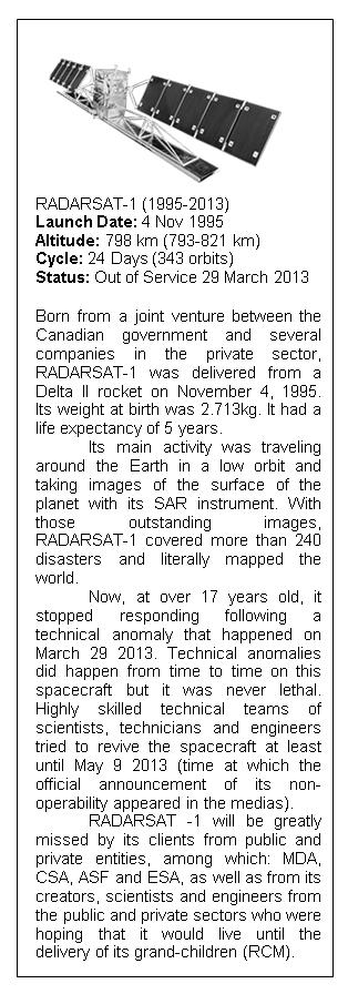
RADARSAT-1 Satellite
 RADARSAT-1 Satellite Summary: RADARSAT-1 is an advanced Earth observation satellite project developed by the Canadian Space Agency (CSA) to monitor environmental change and to support resource sustainability.
Commissioning of the NigeriaSat-2 High Resolution Imaging Mission
 Changing the economics of space Commissioning of the NigeriaSat-2 High Resolution Imaging Mission Phil Davies (presenting) SSTL Francis Chizea - NASRDA Andrew Cawthorne SSTL Andrew Carrel - SSTL Luis Gomes
Soil moisture retrieval using ALOS PALSAR
 Soil moisture retrieval using ALOS PALSAR T. J. Jackson, R. Bindlish and M. Cosh USDA ARS Hydrology and Remote Sensing Lab, Beltsville, MD J. Shi University of California Santa Barbara, CA November 6,
ALOS-Indonesia POLinSAR Experiment (AIPEX): First Result*
: First Result*") ALOS-Indonesia POLinSAR Experiment (AIPEX): First Result* Mahmud Raimadoya(1), Ludmila Zakharova(2), Bambang Trisasongko(1), Nurwadjedi(3) (1) Bogor Agricultural University (IPB), P.O. Box 2049, Bogor
ALOS-Indonesia POLinSAR Experiment (AIPEX): First Result* Mahmud Raimadoya(1), Ludmila Zakharova(2), Bambang Trisasongko(1), Nurwadjedi(3) (1) Bogor Agricultural University (IPB), P.O. Box 2049, Bogor
The Performance of the ERS-2 SAR after 15 Years
 The Performance of the ERS-2 SAR after 15 Years Peter Meadows (1), Nuno Miranda (2), Alan Pilgrim (1) & Emma Griffiths (3) (1) BAE SYSTEMS Advanced Technology Centre, West Hanningfield Road, Great Baddow,
Introduction to Galileo PRS
 Introduction to Galileo PRS Fabio Covello 20/09/2017 ESA UNCLASSIFIED - For Official Use Galileo mission figures The Galileo Space Segment: 30 satellites (full constellation) Walker 24/3/1 constellation
European Space Agency and IPY
 European Space Agency and IPY ESA supports IPY 2007-2008 activities: First ESA step was a dedicated Announcement Opportunity (AO) for EO data provision in support IPY, released in 2006, with data provision
Sub-Mesoscale Imaging of the Ionosphere with SMAP
 Sub-Mesoscale Imaging of the Ionosphere with SMAP Tony Freeman Xiaoqing Pi Xiaoyan Zhou CEOS Workshop, ASF, Fairbanks, Alaska, December 2009 1 Soil Moisture Active-Passive (SMAP) Overview Baseline Mission
ICO S-BAND ANTENNAS TEST PROGRAM
 ICO S-BAND ANTENNAS TEST PROGRAM Peter A. Ilott, Ph.D.; Robert Hladek; Charles Liu, Ph.D.; Bradford Arnold Hughes Space & Communications, El Segundo, CA Abstract The four antenna subsystems on each of
OVERVIEW OF KOMPSAT-3A CALIBRATION AND VALIDATION
 OVERVIEW OF KOMPSAT-3A CALIBRATION AND VALIDATION DooChun Seo 1, GiByeong Hong 1, ChungGil Jin 1, DaeSoon Park 1, SukWon Ji 1 and DongHan Lee 1 1 KARI(Korea Aerospace Space Institute), 45, Eoeun-dong,
PAYLOAD OVERVIEW. 1. Payload Architecture for both concepts
 PAYLOAD OVERVIEW F. Hélière, F. Fois, C-C Lin, M. Aloisio, K. Van t Klooster 1. Payload Architecture for both concepts 2. Technology and Pre-developments a. Ku-band feed and High Power Switch b. High Power
ERS-2 Wind Scatterometer Cyclic Report
 ERS- Wind Scatterometer Cyclic Report From 11 th May 9 to 15 th June 9 Cycle 147 Prepared by: G. De Chiara (scat@eo-sppa.org) Inputs from: H. Hersbach (ECMWF) Issue: 1. Reference ERSE-SPPA-EOPG-TN-9-6
Proba-V QWG#7 Flight & GS status. 3 4 May 2018 ACRI, Sophia-Antipolis
 Proba-V QWG#7 Flight & GS status 3 4 May 2018 ACRI, Sophia-Antipolis Orbit status Slide 2 Orbit status LTDN evolution: 7 May 2013: 10:44:30 1 Dec. 2014: 10:51:08 26 Apr. 2017: 10:36:26 Oct 2017: 10:30
The Role of RADARSAT-2 for Flood and Agriculture Monitoring
 The Role of RADARSAT-2 for Flood and Agriculture Monitoring Gordon Staples MDA Richmond, BC, CANADA gstaples@mda.ca RESTRICTION ON USE, PUBLICATION OR DISCLOSURE OF PROPRETIARY INFORMATION This document
KONGSBERG SATELLITE SERVICES 2017 Line Steinbakk, Director Programs. Himmel og hav - Ålesund 3. Oktober 2017
 KONGSBERG SATELLITE SERVICES 2017 Line Steinbakk, Director Programs Himmel og hav - Ålesund 3. Oktober 2017 KSAT HQ IN TROMSØ 69N Established in 1967 Kongsberg Satellite Services since 2002 World leading
The WVR at Effelsberg. Thomas Krichbaum
 The WVR at Effelsberg Alan Roy Ute Teuber Helge Rottmann Thomas Krichbaum Reinhard Keller Dave Graham Walter Alef The Scanning 18-26 GHz WVR for Effelsberg ν = 18.5 GHz to 26.0 GHz Δν = 900 MHz Channels
Report ITU-R M (07/2014)
") Report ITU-R M.2305-0 (07/2014) Consideration of aggregate radio frequency interference event potentials from multiple Earth exploration-satellite service systems on radionavigation-satellite service receivers
Report ITU-R M.2305-0 (07/2014) Consideration of aggregate radio frequency interference event potentials from multiple Earth exploration-satellite service systems on radionavigation-satellite service receivers
SCANSAR AND SPOTLIGHT IMAGING OPERATION STUDY FOR SAR SATELLITE MISSION
 SCANSAR AND SPOTLIGHT IMAGING OPERATION STUDY FOR SAR SATELLITE MISSION Bor-Han Wu, Meng-Che Wu and Ming-Hwang Shie National Space Organization, National Applied Research Laboratory, Taiwan *Corresponding
METOP SECOND GENERATION SCATTEROMETER MISSION
 METOP SECOND GENERATION SCATTEROMETER MISSION Franco Fois, Chung-Chi Lin, Hubert Barré, Maurizio Betto, Marc Loiselet and Graeme Mason European Space Agency, Keplerlaan 1, 2200 AG Noordwijk ZH, The Netherlands
Emergency Locator Signal Detection and Geolocation Small Satellite Constellation Feasibility Study
 Emergency Locator Signal Detection and Geolocation Small Satellite Constellation Feasibility Study Authors: Adam Gunderson, Celena Byers, David Klumpar Background Aircraft Emergency Locator Transmitters
The Delay-Doppler Altimeter
 Briefing for the Coastal Altimetry Workshop The Delay-Doppler Altimeter R. K. Raney Johns Hopkins University Applied Physics Laboratory 05-07 February 2008 1 What is a Delay-Doppler altimeter? Precision
SATELLITE SUBSYSTEMS. Networks and Communication Department. Dr. Marwah Ahmed
 1 SATELLITE SUBSYSTEMS Networks and Communication Department Dr. Marwah Ahmed Outlines Attitude and Orbit Control System (AOCS) Telemetry, Tracking, Command and Monitoring (TTC & M) Power System Communication
Commissioning the TanDEM-X Ground Segment An Interim Commissioning Phase Perspective
 Commissioning the TanDEM-X Ground Segment An Interim Commissioning Phase Perspective B. Schättler, R. Kahle, R. Metzig, T. Fritz, U. Steinbrecher, M. Wermuth, M. Zink, and TanDEM-X Ground Segment Team
Aquarius/SAC-D Mission Mission Simulators - Gary Lagerloef 6 th Science Meeting; Seattle, WA, USA July 2010
 Aquarius/SAC-D Mission Mission Simulators - Gary Lagerloef 6 th Science Meeting; Seattle, WA, USA Mission Design and Sampling Strategy Sun-synchronous exact repeat orbit 6pm ascending node Altitude 657
PALSAR SCANSAR SCANSAR Interferometry
 PALSAR SCANSAR SCANSAR Interferometry Masanobu Shimada Japan Aerospace Exploration Agency Earth Observation Research Center ALOS PI symposium, Greece Nov. 6 2008 1 Introduction L-band PALSAR strip mode
Design and Performance Simulation of a Ku-Band Rotating Fan-Beam Scatterometer
 Design and Performance Simulation of a Ku-Band Rotating Fan-Beam Scatterometer Xiaolong DONG, Wenming LIN, Di ZHU, (CSSAR/CAS) PO Box 8701, Beijing, 100190, China Tel: +86-10-62582841, Fax: +86-10-62528127
Time Dissemination Research Section, National Bureau of Standards, Boulder, Colorado.
 THE NBS FREQUENCY AND TME SATELLTE EXPERMENT USNG ATS-3 rr by D. W. Hanson, W. F. Hamilton, and L. E. Gatterer Mr. Hanson, Mr. Hamilton, and Mr. Gatterer are with the Frequency and Time Dissemination Research
Upgraded Planar Near-Field Test Range For Large Space Flight Reflector Antennas Testing from L to Ku-Band
 Upgraded Planar Near-Field Test Range For Large Space Flight Reflector Antennas Testing from L to Ku-Band Laurent Roux, Frédéric Viguier, Christian Feat ALCATEL SPACE, Space Antenna Products Line 26 avenue