GEOTECHNICAL APPLICATIONS OF INFRARED OBLIQUE STEREO PHOTOGRAPHY
|
|
|
- Bathsheba Waters
- 6 years ago
- Views:
Transcription
1 Reprinted from: Engineering Geology Practice in Southern California AEG Conference 1992 Long Beach, California GEOTECHNICAL APPLICATIONS OF INFRARED OBLIQUE STEREO PHOTOGRAPHY Woodrow L. Higdon, President Geo-Tech Imagery P.O. Box 2179 Oceanside, California FAX INTRODUCTION Two general areas of aerial photography will be discussed. The first is what affects the appearance of photographic images, and how we can control those aspects to improve information quality. The second area will cover some of the basic interpretations that can be made from this improved image quality with particular emphasis on oblique stereo infrared photography. Oblique stereo photographic images, in particular infrared images. have the capability of being one of the more significant investigative support tools available to the geotechnical professionals, and yet they are the least used and most misunderstood forms of visual information in use today. Generally, the term infrared photography produces a response from most professionals that heat variations are not significant in their investigation, or oblique images are useful for office walls, but not as an investigative tool. The fact is that infrared photography has nothing to do with heat and oblique aerial photography has as many capabilities and uses as the common vertical image. To put this statement in context it is necessary to define some terms and limits for Standard Color vs. Color Infrared photography, and oblique stereo imaging. WAVELENGTHS & FILM The zone of electromagnetic radiation usually referred to as the visible light spectrum, has wavelengths ranging from approximately 400 to 700 nanometers (Fig. 1). The short end of this zone consist of wavelengths that our eyes perceive as the color blue. As one proceeds up the wavelength scale one passes through green, yellow. orange, and red, which is the longest wavelength the human eye can perceive. Beyond the short end of the visible spectrum is ultraviolet. The effects of these wavelengths on photographic images are most apparent as a hazy skyline in standard color photographs. This effect is produced from ultraviolet and blue wavelength light scattering on airborne UV THE SPECTRUM VISIBLE LIGHT V B G Y O R FILM SENSITIVITY RANGE NEAR INFRARED WAVELENGTH IN NANOMETERS 900 IR Figure 1 1
2 particles or moisture. On the opposite end of the visible spectrum is the infrared zone starting at approximately 700 nanometers wavelength. These infrared wavelengths do not produce sensible heat until they attain a wavelength of approximately 1350 nanometers. Imagery that is generated as a function of heat radiation from the longer wavelength part of the infrared spectrum is generally produced by a computer. This type of imagery is referred to as scan imagery. The computer has a series of scanners, each of which is sensitive to a specific wavelength or group of wavelengths. The computer receives information from the scanners. and then builds an image based on preprogrammed criteria. This type of imagery has many uses, but it is not infrared photography. Infrared photographic images are recorded directly on a film base with specific wavelengths of reflected visible and near infrared electromagnetic radiation. Near Infrared is a zone just outside of the long end of the visible spectrum, and the lower end of the infrared range. This zone has wavelengths ranging from approximately 700 to 900 nanometers. This section of the infrared range is not sensible heat. but it can be thought of as an invisible extension of the visible light spectrum. This is why infrared images should not always be equated with heat. If infrared films were heat sensitive they could not be handled for camera loading, as body heat would fog the film. Some type of refrigerated and insulated camera would be needed to shoot the film. So, what actually exists is a film that is not heat sensitive, and has been specially designed to respond to only the near infrared part of the infrared spectrum, and all shorter visible wavelengths. The film was developed during the Second World War as the military wanted a film that would differentiate between natural vegetation and camouflage in the field. It was determined that normal healthy chlorophyll in plants reflect the near infrared wavelengths. This reflectivity provides some significant interpretative parameters that will be discussed later. As the film is also sensitive to all of the shorter wavelengths, including ultraviolet, it is recommended a number 12 yellow filter be used. This filter restricts the passage of blue light and shorter wavelengths that tend to degrade the image resolution, and shift colors. It is important to use the number 12 yellow specified by the film instructions. There are several types of color infrared film available, and consideration should be given to which one to use for best results. The only color 35mm infrared used in the United States today is Ektachrome Infrared, which is an E-4 process film. Even though most geologists have access to a 35mm camera, and the processing is not impossible to find, this format is not recommended because the 35mm format is just too small for good aerial photos. The format limitations are compounded by the fact that the E-4 process is an older process that is in little use today, which means the film will have to be shipped to some major processing center with E-4 capabilities. The turn around times varies from four to six weeks. The commonly used infrared films are designated as aerial infrared and are available in negative and positive (Color Slide) film types. The smallest film size available is 70mm roll film, followed by 4 X 5 inch format films and larger. Even though a medium format camera with 70mm back capabilities is not the average camera of geotechnical professionals, it is still the best all around system for low elevation aerials, ease of handling, transport, versatility, and image economics. Negative-type films tend to be less expensive than positive type films. and the prints generated from negatives are also generally less expensive than prints from positives. However, positive (color slide) 2
3 films are superior for geotechnical applications. Positive do not require prints to view and evaluate images. This capability eliminates the need, as well as the cost, of printing every single frame. It also allows direct evaluation of original images. These originals are superior in resolution and image quality compared to prints produced from any type of film. There are no photographic papers on the general market capable of reproducing all of the detail and color variation that exist in an original film. This positive infrared film is called Aerochrome Infrared 2443 and is available from authorized Kodak professional film dealers. Aerial infrared films do not have standard ASA ratings that can be used to set camera light meters for appropriate exposure. In fact, there is no standard exposure for all conditions, and it will vary widely depending upon a number of factors. If a qualified professional experienced with infrared films is not being hired for your project shooting, then start with an ASA of 100 and experiment to establish norms for various conditions including the following: 1. Type of light metering system being used. 2. Percent of ground vegetation cover. 3. Percent and type of lithologies exposed. 4. Sun angle/time of day. 5. Percent of horizon or skyline included in picture (Oblique). 6. Filtration used over lens. 7. Light transmission characteristics of optics. There are also a number of secondary image enhancements associated with positive color infrared films. Positive films tend to be higher contrast than negative films. Many times there are ground features with subtle light reflection differences that are not recorded by lower contrast negative type films or they become lost in reproduction. This pumped up contrast also affects color difference separation which can add additional interpretative capabilities. If positive films are so much better for airphoto interpretation, why don't the aerial companies use positive films instead of negative films as their standard? The answers are money, ease of use, and the primary application was not planned for use by geologists. As indicated earlier, negative films are easier to shoot, and color prints must be generated for analysis. The ease of use factor is that negative films have a very wide exposure latitude compared to positive films. This means that best exposure can be missed by several F-stops with negative films, and you will still be able to generate a good color print from the negative. If you miss best exposure on a positive film by more than one half F Stop, there will be substantial loss in image quality. If an aerial company has to re-fly a project due to bad exposure, this costs them money, and the chance of getting poorly exposed film on negatives is substantially less compared to using positive films. The primary planned use of airphotos for more than fifty years has been cartographic, or map making applications. The map making industry and the equipment they use has been designed to use negative type films and their associated prints. Aerial photographic images seldom, if ever, are preplanned specifically for geotechnical interpretation. The overall commercial photography industry has also moved almost exclusively to positive films. 3
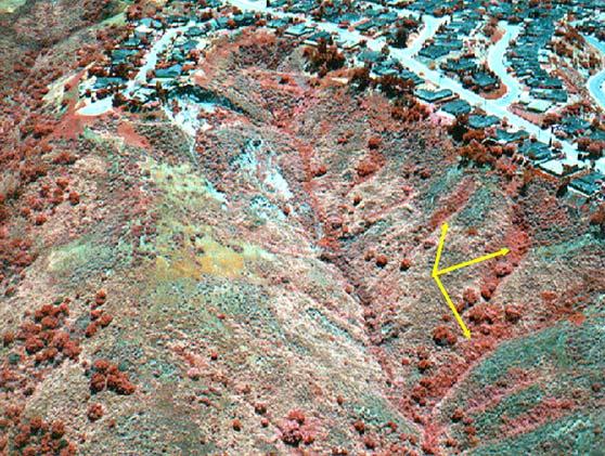
4 Botany might be considered to be a little out of place here, however it is extremely important. Geologist have known for years that many formations or their contacts could be mapped by the type of vegetation growing on them. The chlorophyll structure is one of the wonders of nature that allows plants to generate the nutrients, in this case glucose, that feeds the plant. The plant extracts carbon dioxide (CO 2 ) from the atmosphere and water (H 2 O) from the ground or air. The chlorophyll structure combines the carbon and hydrogen from the two molecules to produce a form of sugar or glucose. Let's extend the thought processes one step further keeping in mind the responses of near infrared light to chlorophyll, the function of chlorophyll. and structural geology. 1. The more chlorophyll a plant has, the more water it needs to function. 2. Plants tend to seek out ground and groundwater conditions that are most conducive to its long term growth and development. 3. Broad leaf varieties of plants have abundant chlorophyll and require abundant and long term water supplies to survive, as compared to desert varieties that have little to no leaf structures and only bloom for short periods each year. 4. Chlorophyll is the most sensitive indicator of a plants health. With adequate water and basic nutrients the chlorophyll will have high activity and therefore high reflectivity in the near infrared. 5. Geologic structure controls groundwater, and water controls vegetation. APPLICATIONS With theses concepts in mind let's find a landslide and a fault that cannot be seen in the field, and that do not show up in standard color or black & white photographic images. Landslides produce ground rupture along their boundaries and normally produce various types of perched groundwater or springs. Even though the visible surface expression will change or even be obliterated with time, the subsurface conditions remain. Head and lateral grabens will infill with colluvium, and many times produce perched water conditions that provide a reservoir for months, or years. These areas of abundant near surface water will attract appropriate types of vegetation. The vegetation in these areas of good water supply will be healthier and therefore have a higher near infrared reflectance than nearby plants of a similar type with less water, or plants of other varieties with smaller leaf structures. These structural groundwater controls of vegetation can be made visible to the human eye with infrared films. These trends, lineaments. and curvatures can then be interpreted. Aerial photograph number 1 is a frame taken from a series of oblique stereo images in southern Orange County, California. The area is mostly siltstone of the Miocene Capistrano Formation capped by terrace deposits. The creek channel is marked by vivid red vegetation due to the abundant water supply stored in alluvial materials. Just upslope and parallel to the channel, a well defined lineament can be seen. Upslope of the lineament the vegetation is thicker and larger with prominent bushes showing vivid red coloration. Below the lineament. and downslope, the vegetation is smaller with little to minimal red vegetation reflections. The lineament is a fault that is generating a ground water barrier that restricts the flow of 4
5 water to the downslope side of the fault. The abundant water backing up on the upslope side of the fault attracts vegetation forms that are broad leaf types with abundant chlorophyll, and therefore high infrared reflection. The right visual limit of the fault terminates at the boundary of an ancient landslide. The lateral boundaries and the head graben are marked by large vivid red vegetation. A bulge in the channel marks the toe of the feature. Neither the fault or the landslide were detected during an earlier geotechnical investigation. The basic interpretations can be extended in a number of different directions and over a variety of ground conditions. The result is that "invisible" ground features can be detected and delineated. An extensive knowledge of plants and their environments is not a necessity, however, the more knowledge you have the better your interpretations will become. There is no one time of the year that is best for all conditions. The number of detectable features can vary weekly, monthly, or yearly. Some features drain slowly with large reservoir capacity and control vegetation year round. However, this same feature may be obscured in the rainy season in a high rainfall climate as all surrounding vegetation is also well watered and healthy. This feature may only be visible during the middle or late part of the dry season. Other features, in the same area, may drain quickly and leave no trace in middle or late summer. In a somewhat dryer climate many features may be seen best during the middle or late rainy season. For these reason and others, flight time considerations are important. The best possible alternative, based on economics, is to fly the site at least two times during the year with a six month separation between flights. If time and economics permit, make additional flights. Each flight should be preplanned and areas of priority detected in previous flights targeted for special shooting. Potential and old debris flows can also be detected and delineated in much the same way. These features tend to build up in old channels or pockets on hillsides with a variety of slope angles and sizes. These alluvial or colluvial structures are normally loose and porous compared to surrounding bedrock materials and they transmit and trap water. These perched water conditions also control vegetation and are often found along the boundaries or within old landslides that obscure old slides on standard photographic images. Other potential debris flows, like deep weathering areas with subsurface water, will show many of the same earmarks described above. Aerial photograph number 2 shows a series of these potential debris flow structures. The right hand wall of the canyon is marked by a number of linear and pocket plumes of high reflection vegetation. The life of these reflections, like landslides, will vary with size, storage capacity, water supply and climate. Anytime steep natural hillsides are to be adjacent to developed areas, they should be investigated for potential debris flows. There is also an unrepaired reactivated ancient landslide visible in the head of the canyon. This landslide, like many landslides occurring in developed areas today, are not new landslides. They are reactivated ancient landslide that were missed by standard investigation techniques. GROUND WATER AND LITHOLOGY All of the objects we see as color are a combination of both reflection and absorption of light. Near Infrared is totally absorbed by water. This characteristic means that areas with near surface groundwater, adequate to produce a 5
6 moisture variation at surface, will photograph a little darker on infrared film, than the same ground condition nearby with no surface moisture. This is an additional interpretative parameter to add to the above infrared capabilities. Often high or perched groundwater conditions will not only produce the deep red vegetation reflections, but also darker areas on the ground indicating the near surface limits of the water body. In some areas there may be no vegetation and only the slightly darker areas marking groundwater springs or seepage. The combined effects of vegetation near infrared reflection, increased contrast, and infrared absorption by water, also makes infrared films an excellent tool for delineating and mapping land/water interfaces in heavily vegetated areas. The deep red color of vegetation and the dark blue to black of water is a substantial contrast improvement over conventional color photos that show green and dirty green or brown. Rock types with contrasting infrared reflections can add an additional interpretative parameter. Rock types containing quartz, like sandstone, reflect more near infrared than siltstone or claystone. Limestone produce a high reflection like sandstone. These variations in rock reflections may produce lineaments on ground surfaces that are not visible to the eye, standard color, or black and white imagery forms, but can be seen in color infrared. These lithologic variations may be produced as the slide block displaces bedding structures, or as the graben infills with colluvium that may contrast with adjacent slide debris or bedrock. This type of variation is very useful in finding faults as the lineaments become longer and easier to see. For landslides it may provide that one additional piece of information necessary to make an interpretation. USE OF OBLIQUE STEREO PHOTOGRAPHS It has long been the opinion of most professionals that vertical aerial photos are the prime investigation image form, and that oblique aerials are mostly useful as office displays. The fact is that for every piece of information obtained from a set of vertical images, two to three pieces of information can be obtained from a set of planned stereo oblique images. The same ratio applies in available applications. This does not mean that verticals should be replaced by obliques. It is obvious that there are important applications in verticals that cannot be replaced by oblique images. Oblique aerial imagery is just one more tool that must be added to the geologic tool box. Oblique aerial images can be generated in stereo, just like verticals. The biggest single advantage of an oblique geotechnical flight over a vertical flight is perspective. Perspective, in this case, is a position of view. Vertical images have only one perspective relative to the ground, no matter how many frames are generated. Obliques have an infinite number of possible perspectives. Many ground features do not show up in vertical images simply because the angle of view is wrong to see the shape or texture of the feature. This capability has been utilized, in a limited way, by geologists in the form of low sun angle photography. In this case lighting is allowed to move to a very different position from normal, and in some cases oblique photography was even used. This perspective benefit associated with oblique images increases significantly as terrain relief increases, and is optimized with stereo viewing. As terrain relief increases, vertical exaggeration increases and many features located in those areas become obscured in vertical images. Oblique stereos are the best image form to use on projects that have vertical or near vertical faces to investigate. These types of projects include coastal bluff studies, dam 6
7 and reservoir sites, and any kind of steep high relief terrain. For every feature detected in a vertical flight, at least one more feature will be found in a planned oblique stereo flight. This translates to at least 100% improvement in information yield. If any of those oblique detected features are major hazards, that would have gone undetected until grading or development, substantial amounts of time and money are saved. Therefore the economic benefits to clients far outweighs the small cost of generating such imagery. Other secondary benefits associated with oblique image flights are the ease of varying scales in photos without substantial cost increases, and improved communications and documentation. Vertical aerial companies charge for a new flight each time they change scales. Technical photographers shooting from helicopters seldom charge extra for elevation changes, and a helicopter is the best method of shooting oblique stereo photos. Non-professionals do not visualize vertical images like most geologists. Obliques are superior when communicating with lay groups or documenting vertical features. It is a rare project that cannot benefit from planned geotechnical oblique stereo photos. The aspects of relatively expensive cameras, special shooting techniques, and films that are somewhat difficult to use should not be allowed to deter a geologist from attempting these capabilities. The difference between using a regular commercial photographer and placing these photographic and interpretative skills in the hands of a geologist, is literally like night and day. The geologists ability to preplan imagery based upon geotechnical skills, and then evaluate site conditions during flight and make appropriate adjustments is critical for best results. 7

8 Airphoto #1 Airphoto #2 8
Volume 1 - Module 6 Geometry of Aerial Photography. I. Classification of Photographs. Vertical
 RSCC Volume 1 Introduction to Photo Interpretation and Photogrammetry Table of Contents Module 1 Module 2 Module 3.1 Module 3.2 Module 4 Module 5 Module 6 Module 7 Module 8 Labs Volume 1 - Module 6 Geometry
Acquisition of Aerial Photographs and/or Imagery
 Acquisition of Aerial Photographs and/or Imagery Acquisition of Aerial Photographs and/or Imagery From time to time there is considerable interest in the purchase of special-purpose photography contracted
SFR 406 Spring 2015 Lecture 7 Notes Film Types and Filters
 SFR 406 Spring 2015 Lecture 7 Notes Film Types and Filters 1. Film Resolution Introduction Resolution relates to the smallest size features that can be detected on the film. The resolving power is a related
Acquisition of Aerial Photographs and/or Satellite Imagery
 Acquisition of Aerial Photographs and/or Satellite Imagery Acquisition of Aerial Photographs and/or Imagery From time to time there is considerable interest in the purchase of special-purpose photography
Lecture Series SGL 308: Introduction to Geological Mapping Lecture 8 LECTURE 8 REMOTE SENSING METHODS: THE USE AND INTERPRETATION OF SATELLITE IMAGES
 LECTURE 8 REMOTE SENSING METHODS: THE USE AND INTERPRETATION OF SATELLITE IMAGES LECTURE OUTLINE Page 8.0 Introduction 114 8.1 Objectives 115 115 8.2 Remote Sensing: Method of Operation 8.3 Importance
FOR 353: Air Photo Interpretation and Photogrammetry. Lecture 2. Electromagnetic Energy/Camera and Film characteristics
 FOR 353: Air Photo Interpretation and Photogrammetry Lecture 2 Electromagnetic Energy/Camera and Film characteristics Lecture Outline Electromagnetic Radiation Theory Digital vs. Analog (i.e. film ) Systems
746A27 Remote Sensing and GIS
 746A27 Remote Sensing and GIS Lecture 1 Concepts of remote sensing and Basic principle of Photogrammetry Chandan Roy Guest Lecturer Department of Computer and Information Science Linköping University What
Reflected ultraviolet digital photography with improvised UV image converter
 Rochester Institute of Technology RIT Scholar Works Articles 8-25-2003 Reflected ultraviolet digital photography with improvised UV image converter Andrew Davidhazy Follow this and additional works at:
Radar Imagery for Forest Cover Mapping
 Purdue University Purdue e-pubs LARS Symposia Laboratory for Applications of Remote Sensing 1-1-1981 Radar magery for Forest Cover Mapping D. J. Knowlton R. M. Hoffer Follow this and additional works at:
PHOTOGRAMMETRY STEREOSCOPY FLIGHT PLANNING PHOTOGRAMMETRIC DEFINITIONS GROUND CONTROL INTRODUCTION
 PHOTOGRAMMETRY STEREOSCOPY FLIGHT PLANNING PHOTOGRAMMETRIC DEFINITIONS GROUND CONTROL INTRODUCTION Before aerial photography and photogrammetry became a reliable mapping tool, planimetric and topographic
Geo/SAT 2 INTRODUCTION TO REMOTE SENSING
 Geo/SAT 2 INTRODUCTION TO REMOTE SENSING Paul R. Baumann, Professor Emeritus State University of New York College at Oneonta Oneonta, New York 13820 USA COPYRIGHT 2008 Paul R. Baumann Introduction Remote
Photogrammetry. Lecture 4 September 7, 2005
 Photogrammetry Lecture 4 September 7, 2005 What is Photogrammetry Photogrammetry is the art and science of making accurate measurements by means of aerial photography: Analog photogrammetry (using films:
AR M. Sc. (Rural Technology) II Semester Fundamental of Remote Sensing Model Paper
 II Semester Fundamental of Remote Sensing Model Paper") 1. Multiple choice question ; AR- 7251 M. Sc. (Rural Technology) II Semester Fundamental of Remote Sensing Model Paper 1. Chlorophyll strongly absorbs radition of : (b) Red and Blue wavelength (ii) Which
1. Multiple choice question ; AR- 7251 M. Sc. (Rural Technology) II Semester Fundamental of Remote Sensing Model Paper 1. Chlorophyll strongly absorbs radition of : (b) Red and Blue wavelength (ii) Which
Atmospheric interactions; Aerial Photography; Imaging systems; Intro to Spectroscopy Week #3: September 12, 2018
 GEOL 1460/2461 Ramsey Introduction/Advanced Remote Sensing Fall, 2018 Atmospheric interactions; Aerial Photography; Imaging systems; Intro to Spectroscopy Week #3: September 12, 2018 I. Quick Review from
Conceptual Physics 11 th Edition
 Conceptual Physics 11 th Edition Chapter 27: COLOR This lecture will help you understand: Color in Our World Selective Reflection Selective Transmission Mixing Colored Light Mixing Colored Pigments Why
An NDVI image provides critical crop information that is not visible in an RGB or NIR image of the same scene. For example, plants may appear green
 Normalized Difference Vegetation Index (NDVI) Spectral Band calculation that uses the visible (RGB) and near-infrared (NIR) bands of the electromagnetic spectrum NDVI= + An NDVI image provides critical
Remote Sensing. in Agriculture. Dr. Baqer Ramadhan CRP 514 Geographic Information System. Adel M. Al-Rebh G Term Paper.
 Remote Sensing in Agriculture Term Paper to Dr. Baqer Ramadhan CRP 514 Geographic Information System By Adel M. Al-Rebh G199325390 May 2012 Table of Contents 1.0 Introduction... 4 2.0 Objective... 4 3.0
LASERS. & Protective Glasses. Your guide to Lasers and the Glasses you need to wear for protection.
 LASERS & Protective Glasses Your guide to Lasers and the Glasses you need to wear for protection. FACTS Light & Wavelengths Light is a type of what is called electromagnetic radiation. Radio waves, x-rays,
FOR 474: Forest Inventory. FOR 474: Forest Inventory. Why do we Care About Forest Sampling?
 FOR 474: Forest Inventory 1. Advanced Forest Inventory The Need for Forest Sampling Brief Intro to Remote Sensing and GIS Readings: FOR 474: Forest Inventory Related Courses! FOR 274: Forest Measurements
Digital Photography: Fundamentals of Light, Color, & Exposure Part II Michael J. Glagola - December 9, 2006
 Digital Photography: Fundamentals of Light, Color, & Exposure Part II Michael J. Glagola - December 9, 2006 12-09-2006 Michael J. Glagola 2006 2 12-09-2006 Michael J. Glagola 2006 3 -OR- Why does the picture
Conceptual Physics Fundamentals
 Conceptual Physics Fundamentals Chapter 13: LIGHT WAVES This lecture will help you understand: Electromagnetic Spectrum Transparent and Opaque Materials Color Why the Sky is Blue, Sunsets are Red, and
Making NDVI Images using the Sony F717 Nightshot Digital Camera and IR Filters and Software Created for Interpreting Digital Images.
 Making NDVI Images using the Sony F717 Nightshot Digital Camera and IR Filters and Software Created for Interpreting Digital Images Draft 1 John Pickle Museum of Science October 14, 2004 Digital Cameras
KODAK Infrared AEROGRAPHIC Film 2424
 AS-58 KODAK Infrared AEROGRAPHIC Film 2424 KODAK Infrared AEROGRAPHIC Film 2424 is a black-and-white, negative aerial camera film sensitive to infrared radiation as well as to ultraviolet and visible radiation.
CAMERA BASICS. Stops of light
 CAMERA BASICS Stops of light A stop of light isn t a quantifiable measurement it s a relative measurement. A stop of light is defined as a doubling or halving of any quantity of light. The word stop is
LAB 2: AERIAL PHOTOGRAPHY AND PHOTOGRAMMETRY PART 1: INTERPRETATION OF AERIAL PHOTOGRAPHY
 E&ES 328 Remote Sensing Laboratory LAB 2: AERIAL PHOTOGRAPHY AND PHOTOGRAMMETRY Due February 22, 2012 PART 1: INTERPRETATION OF AERIAL PHOTOGRAPHY Some of the first aerial photography, employed during
Interpreting land surface features. SWAC module 3
 Interpreting land surface features SWAC module 3 Interpreting land surface features SWAC module 3 Different kinds of image Panchromatic image True-color image False-color image EMR : NASA Echo the bat
Aerial photography and Remote Sensing. Bikini Atoll, 2013 (60 years after nuclear bomb testing)
") Aerial photography and Remote Sensing Bikini Atoll, 2013 (60 years after nuclear bomb testing) Computers have linked mapping techniques under the umbrella term : Geomatics includes all the following spatial
Aerial photography and Remote Sensing Bikini Atoll, 2013 (60 years after nuclear bomb testing) Computers have linked mapping techniques under the umbrella term : Geomatics includes all the following spatial
Exploring the Earth with Remote Sensing: Tucson
 Exploring the Earth with Remote Sensing: Tucson Project ASTRO Chile March 2006 1. Introduction In this laboratory you will explore Tucson and its surroundings with remote sensing. Remote sensing is the
Basics of Photogrammetry Note#6
 Basics of Photogrammetry Note#6 Photogrammetry Art and science of making accurate measurements by means of aerial photography Analog: visual and manual analysis of aerial photographs in hard-copy format
Remote Sensing. Measuring an object from a distance. For GIS, that means using photographic or satellite images to gather spatial data
 Remote Sensing Measuring an object from a distance For GIS, that means using photographic or satellite images to gather spatial data Remote Sensing measures electromagnetic energy reflected or emitted
LlIGHT REVIEW PART 2 DOWNLOAD, PRINT and submit for 100 points
 WRITE ON SCANTRON WITH NUMBER 2 PENCIL DO NOT WRITE ON THIS TEST LlIGHT REVIEW PART 2 DOWNLOAD, PRINT and submit for 100 points Multiple Choice Identify the choice that best completes the statement or
A panchromatic negative film for technical, industrial and aerial photography
 :AVIPHOT PAN 200 A panchromatic negative film for technical, industrial and aerial photography :Aviphot Pan 200 PE1 is a panchromatic negative film, coated onto a transparent polyester base providing excellent
First Exam: New Date. 7 Geographers Tools: Gathering Information. Photographs and Imagery REMOTE SENSING 2/23/2018. Friday, March 2, 2018.
 First Exam: New Date Friday, March 2, 2018. Combination of multiple choice questions and map interpretation. Bring a #2 pencil with eraser. Based on class lectures supplementing chapter 1. Review lecture
11/25/2009 CHAPTER THREE INTRODUCTION INTRODUCTION (CONT D) THE AERIAL CAMERA: LENS PHOTOGRAPHIC SENSORS
 THE AERIAL CAMERA: LENS PHOTOGRAPHIC SENSORS") INTRODUCTION CHAPTER THREE IC SENSORS Photography means to write with light Today s meaning is often expanded to include radiation just outside the visible spectrum, i. e. ultraviolet and near infrared
INTRODUCTION CHAPTER THREE IC SENSORS Photography means to write with light Today s meaning is often expanded to include radiation just outside the visible spectrum, i. e. ultraviolet and near infrared
Remote Sensing. Ch. 3 Microwaves (Part 1 of 2)
") Remote Sensing Ch. 3 Microwaves (Part 1 of 2) 3.1 Introduction 3.2 Radar Basics 3.3 Viewing Geometry and Spatial Resolution 3.4 Radar Image Distortions 3.1 Introduction Microwave (1cm to 1m in wavelength)
Remote Sensing Ch. 3 Microwaves (Part 1 of 2) 3.1 Introduction 3.2 Radar Basics 3.3 Viewing Geometry and Spatial Resolution 3.4 Radar Image Distortions 3.1 Introduction Microwave (1cm to 1m in wavelength)
Chapter 8. Remote sensing
 1. Remote sensing 8.1 Introduction 8.2 Remote sensing 8.3 Resolution 8.4 Landsat 8.5 Geostationary satellites GOES 8.1 Introduction What is remote sensing? One can describe remote sensing in different
Abstract - Aerial Infrared Thermography. g Thermal Mapping as an Asset Management Tool. for Universities, Large Campuses, Buildings
 Abstract - Aerial Infrared Thermography g Thermal Mapping as an Asset Management Tool for Universities, Large Campuses, Buildings Questions, Comments or Suggestions to: Matthew Reuter (267)738-5816 Email:
What is Photogrammetry
 Photogrammetry What is Photogrammetry Photogrammetry is the art and science of making accurate measurements by means of aerial photography: Analog photogrammetry (using films: hard-copy photos) Digital
Basic Digital Image Processing. The Structure of Digital Images. An Overview of Image Processing. Image Restoration: Line Drop-outs
 Basic Digital Image Processing A Basic Introduction to Digital Image Processing ~~~~~~~~~~ Rev. Ronald J. Wasowski, C.S.C. Associate Professor of Environmental Science University of Portland Portland,
746A27 Remote Sensing and GIS. Multi spectral, thermal and hyper spectral sensing and usage
 746A27 Remote Sensing and GIS Lecture 3 Multi spectral, thermal and hyper spectral sensing and usage Chandan Roy Guest Lecturer Department of Computer and Information Science Linköping University Multi
Electromagnetic Waves
 Electromagnetic Waves What is an Electromagnetic Wave? An EM Wave is a disturbance that transfers energy through a field. A field is a area around an object where the object can apply a force on another
On the use of water color missions for lakes in 2021
 Lakes and Climate: The Role of Remote Sensing June 01-02, 2017 On the use of water color missions for lakes in 2021 Cédric G. Fichot Department of Earth and Environment 1 Overview 1. Past and still-ongoing
MULTISPECTRAL AGRICULTURAL ASSESSMENT. Normalized Difference Vegetation Index. Federal Robotics INSPECTION & DOCUMENTATION
 MULTISPECTRAL AGRICULTURAL ASSESSMENT Normalized Difference Vegetation Index INSPECTION & DOCUMENTATION Federal Robotics Clearwater Dr. Amherst, New York 14228 716-221-4181 Sales@FedRobot.com www.fedrobot.com
Wavelength and Frequency Lab
 Name Wavelength and Frequency Lab Purpose: To discover and verify the relationship between Wavelength and Frequency of the Electromagnetic Spectrum. Background Information: Visible light is Electromagnetic
LIGHT AND LIGHTING FUNDAMENTALS. Prepared by Engr. John Paul Timola
 LIGHT AND LIGHTING FUNDAMENTALS Prepared by Engr. John Paul Timola LIGHT a form of radiant energy from natural sources and artificial sources. travels in the form of an electromagnetic wave, so it has
Lecture 13: Remotely Sensed Geospatial Data
 Lecture 13: Remotely Sensed Geospatial Data A. The Electromagnetic Spectrum: The electromagnetic spectrum (Figure 1) indicates the different forms of radiation (or simply stated light) emitted by nature.
Remote Sensing and GIS
 Remote Sensing and GIS Atmosphere Reflected radiation, e.g. Visible Emitted radiation, e.g. Infrared Backscattered radiation, e.g. Radar (λ) Visible TIR Radar & Microwave 11/9/2017 Geo327G/386G, U Texas,
ULTRAVIOLET and INFRARED Photography Summarized
 ULTRAVIOLET and INFRARED Photography Summarized Andrew Davidhazy School of Photographic Arts and Sciences Imaging and Photographic Technology Department Rochester Institute of Technology A large part of
Alternate Light Source Imaging
 Alternate Light Source Imaging This page intentionally left blank Alternate Light Source Imaging Forensic Photography Techniques Norman Marin Jeffrey Buszka Series Editor Larry S. Miller First published
How can we "see" using the Infrared?
 The Infrared Infrared light lies between the visible and microwave portions of the electromagnetic spectrum. Infrared light has a range of wavelengths, just like visible light has wavelengths that range
Sample Copy. Not For Distribution.
 Photogrammetry, GIS & Remote Sensing Quick Reference Book i EDUCREATION PUBLISHING Shubham Vihar, Mangla, Bilaspur, Chhattisgarh - 495001 Website: www.educreation.in Copyright, 2017, S.S. Manugula, V.
Electromagnetic Spectrum
 Electromagnetic Spectrum Wave - Review Waves are oscillations that transport energy. 2 Types of waves: Mechanical waves that require a medium to travel through (sound, water, earthquakes) Electromagnetic
Lidar stands for light detection and ranging. Lidar imagery is created with a laser beam composed of a very narrow light band.
 Lidar stands for light detection and ranging. Lidar imagery is created with a laser beam composed of a very narrow light band. This light can be transmitted over large distances. Normal light is composed
CHAPTER 8 AERIAL PHOTOGRAPHS
 CHAPTER 8 AERIAL PHOTOGRAPHS An aerial photograph is any photograph taken from an airborne vehicle (aircraft, drones, balloons, satellites, and so forth). The aerial photograph has many uses in military
Sensors and Data Interpretation II. Michael Horswell
 Sensors and Data Interpretation II Michael Horswell Defining remote sensing 1. When was the last time you did any remote sensing? acquiring information about something without direct contact 2. What are
Figure 1: Percent reflectance for various features, including the five spectra from Table 1, at different wavelengths from 0.4µm to 1.4µm.
 Section 1: The Electromagnetic Spectrum 1. The wavelength range that has the highest reflectance for broadleaf vegetation and needle leaf vegetation is 0.75µm to 1.05µm. 2. Dry soil can be distinguished
Lesson Title: The Science of Light and Photography Subject Grade Level Timeline. Physical Science minutes. Objectives
 Lesson Title: The Science of Light and Photography Subject Grade Level Timeline Physical Science 5-12 60-90 minutes Objectives This lesson explores some of the ways in which light can be manipulated to
remote sensing? What are the remote sensing principles behind these Definition
 Introduction to remote sensing: Content (1/2) Definition: photogrammetry and remote sensing (PRS) Radiation sources: solar radiation (passive optical RS) earth emission (passive microwave or thermal infrared
Green Team Science - Mrs. Ferdinand
 Date: Homework: May 15, 2018 Waves Study Guide: start reviewing NOW Reminders: Unit Test: Friday, May 18 Unit Test Review: Thursday Turn In Activity 9: Wave Refraction Challenge Question None Agenda /
Infra-Red Photography by David Evans
 Infra-Red Photography by David Evans Several years ago, I took a course at Mohawk on advanced photographic techniques, and one of the topics was infrared (IR) light photography. It intrigued me, because
Experiments in Aerial Photography
 Journal of the Arkansas Academy of Science Volume 23 Article 7 1969 Experiments in Aerial Photography Dan Printup Arkansas Archeological Survey Follow this and additional works at: http://scholarworks.uark.edu/jaas
Electromagnetic Waves & the Electromagnetic Spectrum
 Electromagnetic Waves & the Electromagnetic Spectrum longest wavelength shortest wavelength The Electromagnetic Spectrum The name given to a group of energy waves that are mostly invisible and can travel
Digitizing Film Using the D850 and ES-2 Negative Digitizer
 JULY 23, 2018 INTERMEDIATE Digitizing Film Using the D850 and ES-2 Negative Digitizer The ES 2 can be used with both strip film and mounted slides. Digitizing film is the process of creating digital data
COURSE NAME: PHOTOGRAPHY AND AUDIO VISUAL PRODUCTION (VOCATIONAL) FOR UNDER GRADUATE (FIRST YEAR) PAPER TITLE: BASIC PHOTOGRAPHIC
 FOR UNDER GRADUATE (FIRST YEAR) PAPER TITLE: BASIC PHOTOGRAPHIC") COURSE NAME: PHOTOGRAPHY AND AUDIO VISUAL PRODUCTION (VOCATIONAL) FOR UNDER GRADUATE (FIRST YEAR) PAPER TITLE: BASIC PHOTOGRAPHIC UNIT - 4 : CAMERA CONTROLS - 4 TOPIC: LENS HOOD AND FILTERS OBJECTIVES
COURSE NAME: PHOTOGRAPHY AND AUDIO VISUAL PRODUCTION (VOCATIONAL) FOR UNDER GRADUATE (FIRST YEAR) PAPER TITLE: BASIC PHOTOGRAPHIC UNIT - 4 : CAMERA CONTROLS - 4 TOPIC: LENS HOOD AND FILTERS OBJECTIVES
EASTMAN EXR 200T Film / 5293, 7293
 TECHNICAL INFORMATION DATA SHEET Copyright, Eastman Kodak Company, 2003 1) Description EASTMAN EXR 200T Film / 5293 (35 mm), 7293 (16 mm) is a medium- to high-speed tungsten-balanced color negative camera
Monitoring of mine tailings using satellite and lidar data
 Surveying Monitoring of mine tailings using satellite and lidar data by Prevlan Chetty, Southern Mapping Geospatial This study looks into the use of high resolution satellite imagery from RapidEye and
A map says to you, 'Read me carefully, follow me closely, doubt me not.' It says, 'I am the Earth in the palm of your hand. Without me, you are alone
 A map says to you, 'Read me carefully, follow me closely, doubt me not.' It says, 'I am the Earth in the palm of your hand. Without me, you are alone and lost. Beryl Markham (West With the Night, 1946
Designing a Remote Sensing Project. Many factors to consider: here lumped into 12 sections hold on!! first some basic concepts
 Designing a Remote Sensing Project Many factors to consider: here lumped into 12 sections hold on!! first some basic concepts DVC Geography 160 Introduction to Remote Sensing J. Ellis DigitalGlobe (2006)
ELECTROMAGNETIC WAVES AND LIGHT. Physics 5 th Six Weeks
 ELECTROMAGNETIC WAVES AND LIGHT Physics 5 th Six Weeks What are Electromagnetic Waves Electromagnetic Waves Sound and water waves are examples of waves resulting from energy being transferred from particle
KODAK High Speed Infrared Film
 TECHNICAL DATA / BLACK-AND-WHITE FILM January 1999 F-13 KODAK High Speed Infrared Film KODAK High Speed Infrared Film is a high-speed film with moderately high contrast, sensitive to light and radiant
APCAS/10/21 April 2010 ASIA AND PACIFIC COMMISSION ON AGRICULTURAL STATISTICS TWENTY-THIRD SESSION. Siem Reap, Cambodia, April 2010
 APCAS/10/21 April 2010 Agenda Item 8 ASIA AND PACIFIC COMMISSION ON AGRICULTURAL STATISTICS TWENTY-THIRD SESSION Siem Reap, Cambodia, 26-30 April 2010 The Use of Remote Sensing for Area Estimation by Robert
Chapter 9: Light, Colour and Radiant Energy. Passed a beam of white light through a prism.
 Chapter 9: Light, Colour and Radiant Energy Where is the colour in sunlight? In the 17 th century (1600 s), Sir Isaac Newton conducted a famous experiment. Passed a beam of white light through a prism.
Polarizers, how they work, when to use them, how to use them...
 Polarizers, how they work, when to use them, how to use them... Author's Note: This is a slightly updated version of an article on Polarization that Singh-Ray asked me to write several years ago. During
KODAK EKTACHROME 100 Plus Professional Film
 KODAK EKTACHROME 100 Plus Professional Film TECHNICAL DATA / COLOR REVERSAL FILM July 2007 E-113 This versatile, 100-speed, color transparency film features high color saturation and dependable neutrals
Electromagnetic (Light) Waves Electromagnetic Waves
 Waves Electromagnetic Waves") Physics R Date: Review Questions 1. An ocean wave traveling at 3 m/s has a wavelength of 1.6 meters. a. What is the frequency of the wave? b. What is the period of the wave? Electromagnetic (Light) Waves
Physics R Date: Review Questions 1. An ocean wave traveling at 3 m/s has a wavelength of 1.6 meters. a. What is the frequency of the wave? b. What is the period of the wave? Electromagnetic (Light) Waves
Section Electromagnetic Waves and the Electromagnetic Spectrum
 Section 17.6 Electromagnetic Waves and the Electromagnetic Spectrum Electromagnetic Waves Can you name all the colors of the rainbow? Red, Orange, Yellow, Green, Blue, Indigo, Violet Electromagnetic Waves
Contents Remote Sensing for Studying Earth Surface and Changes
 Contents Remote Sensing for Studying Earth Surface and Changes Anupma Prakash Day : Tuesday Date : September 26, 2008 Audience : AMIDST Participants What is remote sensing? How does remote sensing work?
BLACK CAT PHOTOGRAPHIC RULES-OF- THUMB
 Page 1 of 5 BLACK CAT PHOTOGRAPHIC RULES-OF- THUMB These 50+ photo-cyber-tips are meant to be shared and passed along. Rules-of-thumb are a kind of tool. They help identify a problem or situation. They
Crop Scouting with Drones Identifying Crop Variability with UAVs
 DroneDeploy Crop Scouting with Drones Identifying Crop Variability with UAVs A Guide to Evaluating Plant Health and Detecting Crop Stress with Drone Data Table of Contents 01 Introduction Crop Scouting
Final Examination Introduction to Remote Sensing. Time: 1.5 hrs Max. Marks: 50. Section-I (50 x 1 = 50 Marks)
") Final Examination Introduction to Remote Sensing Time: 1.5 hrs Max. Marks: 50 Note: Attempt all questions. Section-I (50 x 1 = 50 Marks) 1... is the technology of acquiring information about the Earth's
Final Examination Introduction to Remote Sensing Time: 1.5 hrs Max. Marks: 50 Note: Attempt all questions. Section-I (50 x 1 = 50 Marks) 1... is the technology of acquiring information about the Earth's
Aerial Photo Interpretation
 Aerial Photo Interpretation Aerial Photo Interpretation To date, course has focused on skills of photogrammetry Scale Distance Direction Area Height There s another side to Aerial Photography: Interpretation
Dependence of Predicted Dewatering on Size of Hydraulic Stress Used for Groundwater Model Calibration
 Proceedings of Mine Water Solutions 2018 June 12 15, 2018, Vancouver, Canada Published by the University of British Columbia, 2018 Dependence of Predicted Dewatering on Size of Hydraulic Stress Used for
AERIAL PHOTOGRAPHS CHAPTER 8
 CHAPTER 8 AERIAL PHOTOGRAPHS An aerial photograph is any photograph taken from an airborne vehicle (aircraft, drones, balloons) satellites, and so forth). The aerial photograph has many uses in military
Chapter 2 Threat FM 20-3
 Chapter 2 Threat The enemy uses a variety of sensors to detect and identify US soldiers, equipment, and supporting installations. These sensors use visual, ultraviolet (W), infared (IR), radar, acoustic,
RADIO WAVE PROPAGATION
 CHAPTER 2 RADIO WAVE PROPAGATION Radio direction finding (RDF) deals with the direction of arrival of radio waves. Therefore, it is necessary to understand the basic principles involved in the propagation
KODAK EKTACHROME 160T Professional Film / EPT
 TECHNICAL DATA / COLOR REVERSAL FILM May 2007 E-144 KODAK EKTACHROME 160T Professional Film / EPT THIS FILM HAS BEEN DISCONTINUED. KODAK EKTACHROME 160T Professional Film is a medium-speed color-transparency
An Introduction to Remote Sensing & GIS. Introduction
 An Introduction to Remote Sensing & GIS Introduction Remote sensing is the measurement of object properties on Earth s surface using data acquired from aircraft and satellites. It attempts to measure something
First Exam. Geographers Tools: Gathering Information. Photographs and Imagery. SPIN 2 Image of Downtown Atlanta, GA 1995 REMOTE SENSING 9/19/2016
 First Exam Geographers Tools: Gathering Information Prof. Anthony Grande Hunter College Geography Lecture design, content and presentation AFG 0616. Individual images and illustrations may be subject to
10.2 Color and Vision
 10.2 Color and Vision The energy of light explains how different colors are physically different. But it doesn't explain how we see colors. How does the human eye see color? The answer explains why computers
The Radiation Balance
 The Radiation Balance Readings A&B: Ch. 3 (p. 60-69) www: 4. Radiation Lab: 5 Topics 1. Radiation Balance Equation a. Net Radiation b.shortwave Radiation c. Longwave Radiation 2. Global Average 3. Spatial
Philpot & Philipson: Remote Sensing Fundamentals Color 6.1 W.D. Philpot, Cornell University, Fall 2012 W B = W (R + G) R = W (G + B)
 R = W (G + B)") Philpot & Philipson: Remote Sensing Fundamentals olor 6.1 6. OLOR The human visual system is capable of distinguishing among many more colors than it is levels of gray. The range of color perception is
Philpot & Philipson: Remote Sensing Fundamentals olor 6.1 6. OLOR The human visual system is capable of distinguishing among many more colors than it is levels of gray. The range of color perception is
NATIONAL OPEN UNIVERSITY OF NIGERIA COURSE CODE: ESM238 COURSE TITLE: ELEMENTS OF REMOTE SENSING AND AERIAL PHOTO INTERPRETATION
 NATIONAL OPEN UNIVERSITY OF NIGERIA COURSE CODE: ESM238 COURSE TITLE: ELEMENTS OF REMOTE SENSING AND AERIAL PHOTO INTERPRETATION 2 ELEMENTS OF REMOTE SENSING AND AERIAL PHOTO INTERPRETATION By Dr. Oyekanmi
KODAK EKTACHROME 64 Professional Film
 TECHNICAL DATA / COLOR REVERSAL FILM September 2005 E-8 KODAK EKTACHROME 64 Professional Film This color transparency film has become the standard of the industry for use in the studio or under controlled
Int n r t o r d o u d c u ti t on o n to t o Remote Sensing
 Introduction to Remote Sensing Definition of Remote Sensing Remote sensing refers to the activities of recording/observing/perceiving(sensing)objects or events at far away (remote) places. In remote sensing,
Spectro-Densitometers: Versatile Color Measurement Instruments for Printers
 By Hapet Berberian observations of typical proofing and press room Through operations, there would be general consensus that the use of color measurement instruments to measure and control the color reproduction
Zone. ystem. Handbook. Part 2 The Zone System in Practice. by Jeff Curto
 A Zone S ystem Handbook Part 2 The Zone System in Practice by This handout was produced in support of s Camera Position Podcast. Reproduction and redistribution of this document is fine, so long as the
NRS 415 Remote Sensing of Environment
 NRS 415 Remote Sensing of Environment 1 High Oblique Perspective (Side) Low Oblique Perspective (Relief) 2 Aerial Perspective (See What s Hidden) An example of high spatial resolution true color remote
TAKING PICTURES. 1. Be sure your picture has a point of interest.
 TAKING PICTURES 1. Be sure your picture has a point of interest. Each picture should have one principal idea or point of interest. That is, the eye of someone looking at the picture should, at a glance,
Application of Remote Sensing in the Monitoring of Marine pollution. By Atif Shahzad Institute of Environmental Studies University of Karachi
 Application of Remote Sensing in the Monitoring of Marine pollution By Atif Shahzad Institute of Environmental Studies University of Karachi Remote Sensing "Remote sensing is the science (and to some extent,
Lab 6: Multispectral Image Processing Using Band Ratios
 Lab 6: Multispectral Image Processing Using Band Ratios due Dec. 11, 2017 Goals: 1. To learn about the spectral characteristics of vegetation and geologic materials. 2. To experiment with vegetation indices