Abstract - Aerial Infrared Thermography. g Thermal Mapping as an Asset Management Tool. for Universities, Large Campuses, Buildings
|
|
|
- Juniper Skinner
- 6 years ago
- Views:
Transcription
738-5816 Email: airs@comcast.")
1 Abstract - Aerial Infrared Thermography g Thermal Mapping as an Asset Management Tool for Universities, Large Campuses, Buildings Questions, Comments or Suggestions to: Matthew Reuter (267) airs@comcast.net

2 This is a mosaic infrared (IR) image a ~ 1000-acre campus erial Infrared Imagery gery is imagery that shows heat. It is often in the form of a grayscale picture whose shades of gray indicate the differences vity of objects in the image. Typically, objects in the image that look lighter are warmer and those that look darker are ts are the warmest in the images. Black objects are the coolest. Any object with a temperature above absolute zero ( 0 elsius) emits infrared radiation. An infrared picture only shows objects which emit infrared wavelengths in the in visible light wavelengths of 400 to 700 nanometers are detected, but only because they also emit heat. An example of et light that can be seen in the IR imagery. The image may be modified in a number of ways to enhance its value to the end lse-color image or adjusting the brightness and contrast of a grayscale image. The digital images are captured directly to n a CD-ROM.

3 erial IR imaging using fixed-wing aircraft rts with high-angle, straight down infrared images, which reflections and capture large areas at once, making the imagery nd the report less expensive to produce. aptured straight-down or plan view, the report is clear, concise and easy to understand because infrared images, visual AD drawings are reconciled. Used are high-resolution infrared imagers and digital recording equipment. Typical installations of infrared imaging and digital data systems
4 erial Infrared Steam System, Hot Water and Chilled Water Line Imagery are almost always readily visible with infrared imaging, even when no notable problems exist. This is due to the fact that no ation, there is always heat loss from the lines which makes its way to the surface. Problem areas are generally quite evident, ignatures that exceed the norm. Steam line faults normally appear as an overheated line or as a large hotspot in the form of he line. Overheated lines often occur when the steam line is located in a conduit or tunnel. If there is a leak in the line it will with escaping steam. If a steam line is buried directly in the ground with an insulating jacket, a leak will usually saturate t largely ineffective and will begin to transfer heat into the ground around the leak, producing the classic bulge or balloonline. Finally, some leaks may show up as an overheated manhole or vault cover. Manholes or vaults that contain steam hich are leaking will often heat the covers to warmer than normal temperatures. a little misleading, unless one understands and interprets the relative brightness and temperature of a given line correctly. me temperature from one end to the other that passes under different surfaces and materials can exhibit a variety of r example, five different apparent temperatures will result from the same temperature line that runs under a grass-covered t, a concrete loading dock, a gravel-covered area and bare earth pathway. er (HTHW), medium temperature hot water (MTHW) and low temperature hot water (LTHW) lines benefit similarly to densate return systems, with an associated degree of difficulty in surveying because of the declining temperature difference water supply (CHWS) and Chilled water return (CHWR) lines are usually cooler than the surface temperature and can be and leaks as well.
5 Example of mosaic thermal and visible image (red area box shown on next slide)


6 Example of mosaic thermal and visible image (steam line leaks)

7 Steam and condensate return lines heat the ground above the line (insulation failures)

8 Steam and condensate return lines heat the ground above the line (steam line leak)

9 Steam line leak and heated water leaking upward, to the ground surface

10 Buried chilled water line cools the surface above the line

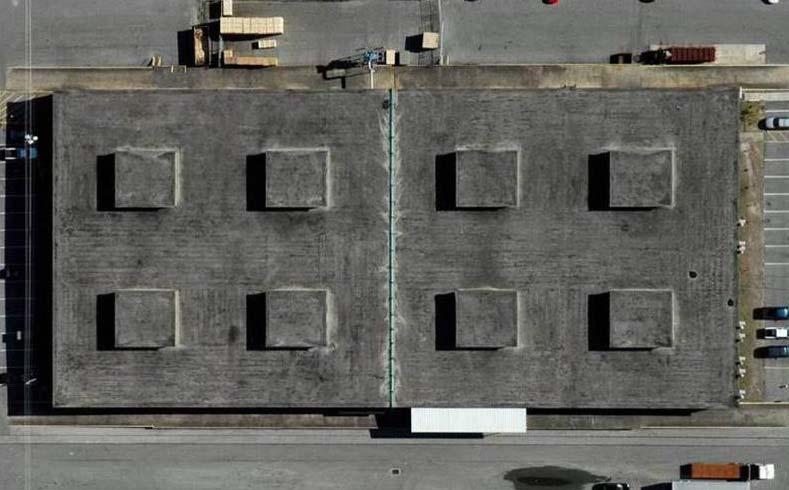
11 erial Infrared Roof Imagery ntamination often manifest themselves as warmer (lighter colored) areas that may be nebulous in shape and sometimes hough they are commonly found in linear or puddle-like shapes. The linear shapes many times follow low areas, drainage ms. Puddle-like round or oblong shapes often form around roof penetrations such as mechanical equipment, standpipes, areas are lighter in color because the latent heat (from daylight sunshine) in the trapped water mass is greater than in the or roof substrate. After sunset when the roof structure cools down, wet areas of roof insulation and other materials llowing our sensitive infrared cameras to detect the sources of heat and record them for later analysis. oisture surveys while standing on the roof is not the best method because imagery from a walk-on survey is not as useful e laws of physics apply to both aerial IR and on-roof IR. A dry roof, low winds and no rain are needed on the night of the dow" when the roof is radiating heat differently from wet and dry areas is longer with aerial infrared because slight ver large areas are recognizable. A high angle of view and high resolution are needed to produce usable imagery.


12 Example of mosaic thermal and visible image (red area box shown on next slide)


13 Example of entrained roof moisture in roofs

14 Example of 4 GRE thermal image of a roof

15 Example of thermal image, visible image and CAD drawing
16 Photograph

17 Thermograph
18 CAD Drawing
19 Example of mosaic visible image of a low-sloped roof

20 Example of mosaic thermal image of a low-sloped roof
21 Example of CAD drawing of a low-sloped roof

22 Example of mosaic visible image of a low-sloped roof with CAD drawing overlay
23 Example of mosaic thermal image of a low-sloped roof with CAD drawing overlay

24 erial Infrared Imagery of Waterways Systems lines, storm water drain discharges and illegal taps into storm water drainage lines can often be identified by their thermal certain times of the year. As these sources of pollution leak, seep or empty into creeks, streams, rivers and lakes, their om their surroundings and they can be pinpointed accurately from the air. Cool temperatures (lower than 40 degrees F) and hours) conditions are required. As a general rule, the lower the ground surface and the water surface temperatures, the more way will exhibit near homogenous temperature patterns except for areas where another liquid has joined the flow. This flow warm as compared to the surface water in a creek, stream, river or lake - particularly during cooler times of the year, due he ground a short distance below the surface. Leaks from nearby lines often come to the surface through lateral transfer to a e bed, or to a slope leading down to the surface of the water. These leak areas and the warm plume of liquid joining and the body of water are visible in the thermal infrared spectrum due to the difference in temperatures of the two liquids. Late g are well suited to this type of inspection because of the cooler water temperatures (ground and surface waters) and view by foliage is minimized. Ground water seeps and outfalls of all types are also easily distinguishable for similar

25 IR image of a storm drain outfall (expanded view shown on next page)

26 IR image of a storm drain outfall
. The ic Services, Inc.")
27 IR image of a storm drain outfall in are trademarked and copyrighted ( ). All data, images or any other documentation is the exclusive property of Stockton Infrared Thermographic Services, Inc. (SITS). The ic Services, Inc., SITS, and other trade names, trademarks, service marks, logos and other commercial symbols (collectively the Marks ) are hereby protected. All content, images, ecifications, standards, procedures, software or other technology, whether patented, licensed, or designated by SITS, are and shall be the sole property of SITS. User shall have no right press written consent of SITS.
Lidar stands for light detection and ranging. Lidar imagery is created with a laser beam composed of a very narrow light band.
 Lidar stands for light detection and ranging. Lidar imagery is created with a laser beam composed of a very narrow light band. This light can be transmitted over large distances. Normal light is composed
SAMPLE REPORT. A Qualitative Infrared Thermo Graphic Survey Of Electrical System Components
 SAMPLE REPORT A Qualitative Infrared Thermo Graphic Survey Of Electrical System Components The Electrical Switchgear of the Water Plant, was the subject of an infrared (IR) survey on 11-3- 2014, Equipment
Infrared Survey Report
 Infrared Survey Report Home of: Mr. and Mrs. Sample Client 926 Main Street Your Town, USA 12345 Prepared by: Qualified Contractor Your Town, USA info@energyscanir.com Toll-Free 888-SCAN 4 IR (888-722-6447)
Combining Technologies: LiDaR, High Resolution Digital Images, Infrared Thermography and Geographic Information Systems
 : LiDaR, High Resolution Digital Images, Infrared Thermography and Geographic Information Systems Presented by: Eldris Ferrer, Ms E, GIS Analyst and Remote Sensing Specialist, CSA Group Alexis Ocasio,
How can we "see" using the Infrared?
 The Infrared Infrared light lies between the visible and microwave portions of the electromagnetic spectrum. Infrared light has a range of wavelengths, just like visible light has wavelengths that range
THE CASE FOR AERIAL INFRARED GREGORY R. STOCKTON FORWARD. The school of frozen toes. Once Upon a Roof. April 2000 Interface 25
 BY GREGORY R. STOCKTON THE CASE FOR AERIAL INFRARED FORWARD Infrared thermography has become a very popular means of testing electrical and mechanical systems over the past fifteen years. As it relates
It s All About Image Analyzing Thermal Images
 It s All About Image Analyzing Thermal Images Objectives: Students will be able to : describe the difference between a thermal image and a visible light image of the same object or scene. determine the
Interpreting land surface features. SWAC module 3
 Interpreting land surface features SWAC module 3 Interpreting land surface features SWAC module 3 Different kinds of image Panchromatic image True-color image False-color image EMR : NASA Echo the bat
Geo/SAT 2 INTRODUCTION TO REMOTE SENSING
 Geo/SAT 2 INTRODUCTION TO REMOTE SENSING Paul R. Baumann, Professor Emeritus State University of New York College at Oneonta Oneonta, New York 13820 USA COPYRIGHT 2008 Paul R. Baumann Introduction Remote
PRODUCT OVERVIEW FOR THE. Corona 350 II FLIR SYSTEMS POLYTECH AB
 PRODUCT OVERVIEW FOR THE Corona 350 II FLIR SYSTEMS POLYTECH AB Table of Contents Table of Contents... 1 Introduction... 2 Overview... 2 Purpose... 2 Airborne Data Acquisition and Management Software (ADAMS)...
BRASELTON WATER AND WASTEWATER DEPARTMENT CONSTRUCTION PLAN REVIEW CHECKLIST May 2006
 Project Name: BRASELTON WATER AND WASTEWATER DEPARTMENT CONSTRUCTION PLAN REVIEW CHECKLIST May 2006 Phase: Unit: # Lots: Development Type (residential, commercial, industrial, etc.) Braselton Project No.
Contents Remote Sensing for Studying Earth Surface and Changes
 Contents Remote Sensing for Studying Earth Surface and Changes Anupma Prakash Day : Tuesday Date : September 26, 2008 Audience : AMIDST Participants What is remote sensing? How does remote sensing work?
HOW GREEN IS THE GROUND
 How clean is the air you breathe? Is swimming water the same as drinking water? How many microbes live in the soil beneath your feet? And what does it all mean? DISCOVER how healthy your neighbourhood
Chapter 1 Overview of imaging GIS
 Chapter 1 Overview of imaging GIS Imaging GIS, a term used in the medical imaging community (Wang 2012), is adopted here to describe a geographic information system (GIS) that displays, enhances, and facilitates
SOMEDAY ALL UNDERLAYMENT WILL BE LIKE RAPTOR
 SOMEDAY ALL UNDERLAYMENT WILL BE LIKE RAPTOR Meets or Exceeds ASTM D226, D4869, D1970, D146 Class A Fire Rated with Asphalt Shingles ASTM E108-11 Perm rating.061 ASTM E 96 ed Requirements for ICC ES AC188(2012)
Key Elements for Better Infrared Thermography
 Key Elements for Better Infrared Thermography R. James Seffrin, Director Infraspection Institute 425 Ellis Street Burlington, NJ 08016 609-239-4788 www.infraspection.com Abstract Successful thermography
Aerial photography and Remote Sensing. Bikini Atoll, 2013 (60 years after nuclear bomb testing)
") Aerial photography and Remote Sensing Bikini Atoll, 2013 (60 years after nuclear bomb testing) Computers have linked mapping techniques under the umbrella term : Geomatics includes all the following spatial
Aerial photography and Remote Sensing Bikini Atoll, 2013 (60 years after nuclear bomb testing) Computers have linked mapping techniques under the umbrella term : Geomatics includes all the following spatial
MICROSCANNER TM D-Series
 MICROSCANNER TM D-Series High Performance Models I N S T R U C T I O N M A N U A L C O R P O R A T I O N 818098 400 Pleasant Street Watertown, MA 02472 (617) 923-9900 800-442-3006 FAX: 617-923-9911 C O
ABSTRACT INTRODUCTION METHOD
 ABSTRACT This research project aims to investigate and illustrate the effects a light source s spectral distribution and colour temperature has on photographic image colour reproduction, and how this often
Uses of Electromagnetic Waves
 Uses of Electromagnetic Waves 1 of 42 Boardworks Ltd 2016 Uses of Electromagnetic Waves 2 of 42 Boardworks Ltd 2016 What are radio waves? 3 of 42 Boardworks Ltd 2016 The broadcast of every radio and television
Testo SuperResolution the patent-pending technology for high-resolution thermal images
 Professional article background article Testo SuperResolution the patent-pending technology for high-resolution thermal images Abstract In many industrial or trade applications, it is necessary to reliably
Modeling Nightscapes of Designed Spaces Case Studies of the University of Arizona and Virginia Tech Campuses
 455 Modeling Nightscapes of Designed Spaces Case Studies of the University of Arizona and Virginia Tech Campuses Mintai KIM Abstract This paper examines two methods for modeling the interaction between
Insulator Testers Frequently Asked Questions. September Version: 1.1
 Insulator Testers Frequently Asked Questions September 2017 Version: 1.1 1 FAQ Contents Page Q1: When is it not safe to work on power lines?... 3 Q2: What is the tolerance of the Positron Insulator Tester
Making NDVI Images using the Sony F717 Nightshot Digital Camera and IR Filters and Software Created for Interpreting Digital Images.
 Making NDVI Images using the Sony F717 Nightshot Digital Camera and IR Filters and Software Created for Interpreting Digital Images Draft 1 John Pickle Museum of Science October 14, 2004 Digital Cameras
Home Inspection Leak and Poor Insulation Detection
 Home Inspection Leak and Poor Insulation Detection A home inspection company wants an alternative method of inspection that takes less time, is more precise, less labor intensive, and gives the inspector
University of Houston Master Construction Specifications Insert Project Name SECTION MECHANICAL SCOPE OF WORK PART 1 - GENERAL
 SECTION 23 00 10 - MECHANICAL SCOPE OF WORK PART 1 - GENERAL 1.1 RELATED DOCUMENTS: A. The Conditions of the Contract and applicable requirements of Division 1, "General Requirements", and Section 23 01
Lecture Series SGL 308: Introduction to Geological Mapping Lecture 8 LECTURE 8 REMOTE SENSING METHODS: THE USE AND INTERPRETATION OF SATELLITE IMAGES
 LECTURE 8 REMOTE SENSING METHODS: THE USE AND INTERPRETATION OF SATELLITE IMAGES LECTURE OUTLINE Page 8.0 Introduction 114 8.1 Objectives 115 115 8.2 Remote Sensing: Method of Operation 8.3 Importance
Introduction. Corona. Corona Cameras. Origo Proposed Corona Camera. Origo Corporation Corona Camera Product Inquiry 1
 Origo Corporation Corona Camera Product Inquiry 1 Introduction This Whitepaper describes Origo s patented corona camera R&D project. Currently, lab and daylight proof-of-concept tests have been conducted
Philpot & Philipson: Remote Sensing Fundamentals Color 6.1 W.D. Philpot, Cornell University, Fall 2012 W B = W (R + G) R = W (G + B)
 R = W (G + B)") Philpot & Philipson: Remote Sensing Fundamentals olor 6.1 6. OLOR The human visual system is capable of distinguishing among many more colors than it is levels of gray. The range of color perception is
Philpot & Philipson: Remote Sensing Fundamentals olor 6.1 6. OLOR The human visual system is capable of distinguishing among many more colors than it is levels of gray. The range of color perception is
Microwave Remote Sensing
 Provide copy on a CD of the UCAR multi-media tutorial to all in class. Assign Ch-7 and Ch-9 (for two weeks) as reading material for this class. HW#4 (Due in two weeks) Problems 1,2,3 and 4 (Chapter 7)
REGISTRATION EXAMINATION, JUNE 2008 DRAINLAYING ANSWER SCHEDULE
 No. 9197 REGISTRATION EXAMINATION, JUNE 2008 DRAINLAYING ANSWER SCHEDULE Plumbers, Gasfitters and Drainlayers oard, 2008. All rights reserved. No part of this publication may be reproduced by any means
Module 4, Investigation 2: Log 1 What features do archaeologists look for on an image?
 What are the seven elements used by geoarchaeologists to analyze and interpret remotely sensed images? Geoarchaeologists face several issues when using remotely sensed images. They must determine the location
Fluke TiR Series Thermal Imagers
 Fluke TiR Series Thermal Imagers Find building problems faster. IR-Fusion Technology infrared and visual images fused together makes infrared easy to understand Designed especially for building and restoration
Scientific Approach to Cool Room Validation. Garry Ward / July 2016
 Scientific Approach to Cool Room Validation. Garry Ward / July 2016 Presenter: Mr. Garry Ward Established Industrial Precision Instruments P/L in 1994. Degree in Chemistry Certified Lv III Thermographer
Autumn Leaf. If you have never painted with Colored Pencils before, please review the Basics videos.
 Autumn Leaf an original design in colored pencils by Marian Jackson, MDA 1353 Rose Creek Court, Lebanon, OH 45036 513-217-4653 website: http://marianjackson.com email: contact@marianjackson.com An online
Asset Protection Cathodic Protection Soil Resistivity Measurement. Work Instruction No.:
 Asset Protection Cathodic Protection Soil Resistivity Measurement Approved by: Manager Pipeline Standards 1 PURPOSE This work instruction describes the processes to be followed when measuring soil resistivity.
Introduction. Introduction. Introduction. Introduction. Introduction
 Identifying habitat change and conservation threats with satellite imagery Extinction crisis Volker Radeloff Department of Forest Ecology and Management Extinction crisis Extinction crisis Conservationists
Visibility of Detail
 Visibility of Detail Radiographic Quality Quality radiographic images represents the, and information is for diagnosis. The of the anatomic structures and the accuracy of their ( ) determine the overall
THERMOGRAPHY. Courtesy of Optris. Fig1 : Thermographic image of steel slabs captured with PI1M
 THERMOGRAPHY Non-contact sensing can provide the ability to evaluate the internal properties of objects without damage or disturbance by observing its shape, color, size, material or appearance. Non-contact
FOR 353: Air Photo Interpretation and Photogrammetry. Lecture 2. Electromagnetic Energy/Camera and Film characteristics
 FOR 353: Air Photo Interpretation and Photogrammetry Lecture 2 Electromagnetic Energy/Camera and Film characteristics Lecture Outline Electromagnetic Radiation Theory Digital vs. Analog (i.e. film ) Systems
Aerial Image Acquisition and Processing Services. Ron Coutts, M.Sc., P.Eng. RemTech, October 15, 2014
 Aerial Image Acquisition and Processing Services Ron Coutts, M.Sc., P.Eng. RemTech, October 15, 2014 Outline Applications & Benefits Image Sources Aircraft Platforms Image Products Sample Images & Comparisons
5 FACTORS INFLUENCING RADIOMETRIC TEMPERATURE MEASUREMENTS
 5 FACTORS INFLUENCING RADIOMETRIC TEMPERATURE MEASUREMENTS CONTENTS Page Introduction 2 1. Radiometry and Surface Characteristics 3 2. Emissivity 4 3. Reflectivity 5 4. Effects of Atmosphere 6 5. Resolution
Competitive Analysis, Color Rendering in White Light
 Comparing Metal Halide, Fluorescent, and Solid State Technologies Jim Dilbeck, May, 2012 Scope This study compares the color rendition characteristics of the three most common commercial lighting technologies;
Chapter 8. Remote sensing
 1. Remote sensing 8.1 Introduction 8.2 Remote sensing 8.3 Resolution 8.4 Landsat 8.5 Geostationary satellites GOES 8.1 Introduction What is remote sensing? One can describe remote sensing in different
NRS 415 Remote Sensing of Environment
 NRS 415 Remote Sensing of Environment 1 High Oblique Perspective (Side) Low Oblique Perspective (Relief) 2 Aerial Perspective (See What s Hidden) An example of high spatial resolution true color remote
to Geospatial Technologies
 What s in a Pixel? A Primer for Remote Sensing What s in a Pixel Development UNH Cooperative Extension Geospatial Technologies Training Center Shane Bradt UConn Cooperative Extension Geospatial Technology
1.0 PURPOSE AND SCOPE
 Questa Rock Pile Stability StudySOP 51v2 Page 1 STANDARD OPERATING PROCEDURE NO. 51 COLLECTING THERMAL IMAGES REVISION LOG Revision Number Description Date 51v0 Original SOP by HRS and JMS 6-7-2004 51v1
DEVELOPMENT OF AN EXPERT SYSTEM FOR CONDITION MONITORING OF SUBMARINES USING IR THERMOGRAPHY
 International Journal of Mechanical Engineering and Technology (IJMET) Volume 8, Issue 4, April 2017, pp. 26 33 Article ID: IJMET_08_04_004 Available online at http://www.iaeme.com/ijmet/issues.asp?jtype=ijmet&vtype=8&itype=4
Active and Passive Microwave Remote Sensing
 Active and Passive Microwave Remote Sensing Passive remote sensing system record EMR that was reflected (e.g., blue, green, red, and near IR) or emitted (e.g., thermal IR) from the surface of the Earth.
UNIVERSITY OF ROCHESTER DESIGN STANDARDS FEBRUARY 29, 2012
 SECTION 01950 - RECORD DRAWINGS & SPACE FLOOR PLANS 1.1 RECORD DRAWINGS MATERIAL AND FORMAT A. Definition 1. Final record drawings, or as-builts, are drawings, which are revised to reflect the changes
Occupancy Sensor Placement and Technology. Best Practices Crestron Electronics, Inc.
 Occupancy Sensor Placement and Technology Best Practices Crestron Electronics, Inc. Crestron product development software is licensed to Crestron dealers and Crestron Service Providers (CSPs) under a limited
INSTALLATION GUIDE DECKING.
 INSTALLATION GUIDE DECKING www.ttp-online.de/resysta CONTENT LATEST TEST RESULT Classification C, DIN 51097: Features, made by, best skid-resistance properties and is eminently suitable for wet barefoot
Handheld Infrared Thermometers
 DX SERIES Handheld Infrared Thermometers User s Guide EXERGEN 400 Pleasant Street - Watertown, MA 02472 Phone: 617.923.9900 Fax: 617.923.9911 www.exergen.com e-mail: industrial@exergen.com Table of Contents
Color Theory and Mixing
 MODULE 4 Color Theory and Mixing? What is explored in this module? In this module, we ll look at basic color theory and mixing colors. You ll find that color theory and mixing is not a perfect science.
Agenda. Interior Painting Exterior Painting Typical Problems Low VOC Paints
 Painting 101 Agenda Interior Painting Exterior Painting Typical Problems Low VOC Paints Interior Painting Flat Requires less prep (spot patch & prime) Less durable Eggshell More durable than flat Requires
Excavating, Backfilling, and Compaction for Utilities Piping (Plumbing).
.") SECTION 15047 - IDENTIFICATION PART 1 GENERAL 1.01 SUMMARY A. Section Includes: Identification including necessary accessories indicated on Construction Documents and specified in this section or as required
SECTION 15047 - IDENTIFICATION PART 1 GENERAL 1.01 SUMMARY A. Section Includes: Identification including necessary accessories indicated on Construction Documents and specified in this section or as required
Electromagnetic Waves
 Electromagnetic Waves What is an Electromagnetic Wave? An EM Wave is a disturbance that transfers energy through a field. A field is a area around an object where the object can apply a force on another
Using Multi-spectral Imagery in MapInfo Pro Advanced
 Using Multi-spectral Imagery in MapInfo Pro Advanced MapInfo Pro Advanced Tom Probert, Global Product Manager MapInfo Pro Advanced: Intuitive interface for using multi-spectral / hyper-spectral imagery
Installation and user manual EFIT 850 sensor
 Installation and user manual EFIT 850 sensor GB-DAS 1 Table of content 1 Sensors and control zones 3 1.1 Sensor types and function 3 1.2 Control zones 4 1.3 Assign sensors to control zones 5 2 Placing
The human visual system
 The human visual system Vision and hearing are the two most important means by which humans perceive the outside world. 1 Low-level vision Light is the electromagnetic radiation that stimulates our visual
Color Temperature Color temperature is distinctly different from color and also it is different from the warm/cold contrast described earlier.
 Color Temperature Color temperature is distinctly different from color and also it is different from the warm/cold contrast described earlier. Color temperature describes the actual temperature of a black
IT0654 US ARMY INTELLIGENCE CENTER AND SCHOOL INFRARED IMAGERY
 SUBCOURSE EDITION A US ARMY INTELLIGENCE CENTER AND SCHOOL INFRARED IMAGERY INFRARED IMAGERY Subcourse Number IT 0654 EDITION A U.S. Army Intelligence Center and School Fort Huachuca, Arizona 85613-7000
Continuous Wave Laser Illumination: The Clear Choice over Thermal Imaging for Long-Range, High-Magnification Night Vision Perimeter Protection
 Continuous Wave Laser Illumination: The Clear Choice over Thermal Imaging for Long-Range, High- September 2008 Contents Executive Summary...3 Thermal Imaging and Continuous Wave Laser Illumination Defined...3
INDEX 1.- LIGHT. DEFINITION 2.- TYPES OF LIGHT
 LIGHT INDEX 1.- LIGHT. DEFINITION 2.- TYPES OF LIGHT a.- NATURAL LIGHT b.- ARTIFICIAL LIGHT 3.- THE CONCEPT OF LIGHT AS A GRAPHIC SYMBOL. TONE AND VALUE 4.- SHADOWS. TYPES OF SHADOWS USE OF SHADOWS 5.-
Surface Temperature Mapping of the University of Northern Iowa Campus Using High Resolution Thermal Infrared Aerial Imageries
 Sensors 2008, 8, 5055-5068; DOI: 10.3390/s8085055 Article OPEN ACCESS sensors ISSN 1424-8220 www.mdpi.org/sensors Surface Temperature Mapping of the University of Northern Iowa Campus Using High Resolution
Particulate Control O&M Training. APC/PCUG Conference July 12-16, 2009 The Woodlands, TX
 Particulate Control O&M Training APC/PCUG Conference July 12-16, 2009 The Woodlands, TX WPCA Particulate Training Seminar July 11, 2009 ESP Power Supply Choices Slide No 1 Precipitator Power Supplies Conventional
THERMAL IMAGING GUIDEBOOK FOR BUILDING AND RENEWABLE ENERGY APPLICATIONS
 THERMAL IMAGING GUIDEBOOK FOR BUILDING AND RENEWABLE ENERGY APPLICATIONS An informative guide for the use of thermal imaging cameras for inspecting buildings, solar panels and windmills. Content 1. The
A map says to you, 'Read me carefully, follow me closely, doubt me not.' It says, 'I am the Earth in the palm of your hand. Without me, you are alone
 A map says to you, 'Read me carefully, follow me closely, doubt me not.' It says, 'I am the Earth in the palm of your hand. Without me, you are alone and lost. Beryl Markham (West With the Night, 1946
Diversification of Your Infrared Business A Peek Into the Petrochemical & Chemical World
 Diversification of Your Infrared Business A Peek Into the Petrochemical & Chemical World Sonny James, Level III Certified Infrared Thermographer ASNT NDT Level III IR, MT, PT, UT & RT Certified Welding
Understanding the Role of Thermography in Energy Auditing: Current Practices and the Potential for Automated Solutions
 Understanding the Role of Thermography in Energy Auditing: Current Practices and the Potential for Automated Solutions Matthew Louis Mauriello 1, Leyla Norooz 2, Jon E. Froehlich 1 Makeability Lab Human-Computer
Welcome to TruTech Training!
 Welcome to TruTech Training! We ll be starting in just a few moments www.trutechtools.com 888-224-3437 Making measurement science work! If you are having trouble connecting, please email: Bill@TruTechTools.com
First Exam: New Date. 7 Geographers Tools: Gathering Information. Photographs and Imagery REMOTE SENSING 2/23/2018. Friday, March 2, 2018.
 First Exam: New Date Friday, March 2, 2018. Combination of multiple choice questions and map interpretation. Bring a #2 pencil with eraser. Based on class lectures supplementing chapter 1. Review lecture
Chapter 16 Light Waves and Color
 Chapter 16 Light Waves and Color Lecture PowerPoint Copyright The McGraw-Hill Companies, Inc. Permission required for reproduction or display. What causes color? What causes reflection? What causes color?
GB-DAS. Installation and user manual Devireg 850 sensor
 GB-DAS Installation and user manual Devireg 850 sensor 1 Table of content 1 Sensors and control zones 3 1.1 Sensor types and function 3 1.2 Control zones 4 1.3 Assign sensors to control zones 5 2 Placing
CONDITIONAL ASSESSMENT OF CIVIL STRUCTURES BY ADVANCED NDT METHODS
 e-issn 2455 1392 Volume 3 Issue 3, March 2017 pp. 127 133 Scientific Journal Impact Factor : 3.468 http://www.ijcter.com CONDITIONAL ASSESSMENT OF CIVIL STRUCTURES BY ADVANCED NDT METHODS Mr.C.Pranesh
UAV applications for oil spill detection, suspended matter distribution and ice monitoring first tests and trials in Estonia 2015/2016
 UAV applications for oil spill detection, suspended matter distribution and ice monitoring first tests and trials in Estonia 2015/2016 Sander Rikka Marine Systems Institute at TUT 1.11.2016 1 Outlook Introduction
Govt. Engineering College Jhalawar Model Question Paper Subject- Remote Sensing & GIS
 Govt. Engineering College Jhalawar Model Question Paper Subject- Remote Sensing & GIS Time: Max. Marks: Q1. What is remote Sensing? Explain the basic components of a Remote Sensing system. Q2. What is
Esthec. Terrace. Manual for Assembly and Installation
 Esthec Terrace Manual for Assembly and Installation 0 Table of Content 1. Introduction... 2 2. Factsheet... 3 3. Part-description... 4 3.1 Esthec Terrace profile... 4 3.2 3.3 Esthec Terrace side-profile...
19 Setting Up Your Monitor for Color Management
 19 Setting Up Your Monitor for Color Management The most basic requirement for color management is to calibrate your monitor and create an ICC profile for it. Applications that support color management
I was not able to test the configuration of UHC + MC IR cut with the UHC on the camera side of the IR as my UHC is 2 and the MC IR is 1.25.
 Managing IR in Video Astronomy by Jim Thompson, P.Eng Test Report #1 August 16 th, 2011 Objectives: My objective in last night s test was to visually compare how blocking the infrared portion of the spectrum
ISO INTERNATIONAL STANDARD. Condition monitoring and diagnostics of machines Thermography Part 1: General procedures
 INTERNATIONAL STANDARD ISO 18434-1 First edition 2008-03-01 Condition monitoring and diagnostics of machines Thermography Part 1: General procedures Surveillance et diagnostic de l'état des machines Thermographie
GEOTECHNICAL APPLICATIONS OF INFRARED OBLIQUE STEREO PHOTOGRAPHY
 Reprinted from: Engineering Geology Practice in Southern California AEG Conference 1992 Long Beach, California GEOTECHNICAL APPLICATIONS OF INFRARED OBLIQUE STEREO PHOTOGRAPHY Woodrow L. Higdon, President
Comparison of passive millimeter-wave and IR imagery in a nautical environment
 Comparison of passive millimeter-wave and IR imagery in a nautical environment Appleby, R., & Coward, P. (2009). Comparison of passive millimeter-wave and IR imagery in a nautical environment. 1-8. Paper
Mini Market Study Report August 2011
 Naval Surface Warfare Center (NAVSEA) Crane Division Two Band Imaging System (US Patent No. 6,969,856) Mini Market Study Report August 2011 Sponsored by: Integrated Technology Transfer Network, California
LAB 2: AERIAL PHOTOGRAPHY AND PHOTOGRAMMETRY PART 1: INTERPRETATION OF AERIAL PHOTOGRAPHY
 E&ES 328 Remote Sensing Laboratory LAB 2: AERIAL PHOTOGRAPHY AND PHOTOGRAMMETRY Due February 22, 2012 PART 1: INTERPRETATION OF AERIAL PHOTOGRAPHY Some of the first aerial photography, employed during
Sensors and Data Interpretation II. Michael Horswell
 Sensors and Data Interpretation II Michael Horswell Defining remote sensing 1. When was the last time you did any remote sensing? acquiring information about something without direct contact 2. What are
The first commercial thermal imaging camera was sold in 1965 for high voltage power line inspections, by what would later become FLIR Systems.
 Introduction The first commercial thermal imaging camera was sold in 1965 for high voltage power line inspections, by what would later become FLIR Systems. Since then thermal imaging technology has evolved.
PentaVac Vacuum Technology
 PentaVac Vacuum Technology Scientific CCD Applications CCD imaging sensors are used extensively in high-end imaging applications, enabling acquisition of quantitative images with both high (spatial) resolution
Five Star Panel Installation Instructions
 Five Star Panel Installation Instructions How to Store Five Star Panels You will need to store FIVE STAR PANELS in dry place to prevent staining, deterioration and possibly void all warranties. Stand the
RGB colours: Display onscreen = RGB
 RGB colours: http://www.colorspire.com/rgb-color-wheel/ Display onscreen = RGB DIGITAL DATA and DISPLAY Myth: Most satellite images are not photos Photographs are also 'images', but digital images are
Toward an Integrated Nondestructive Pavement Testing Management Information System Using Infrared Thermography
 124 TRANSPORTATION RESEARCH RECORD 1215 Toward an Integrated Nondestructive Pavement Testing Management Information System Using Infrared Thermography GARY J. WEIL AND LONNIE E. HAEFNER This paper describes
INSTRUCTIONS FOR THE SAFE APPLICATION OF CABLES
 THE SAFE APPLICATIO OF CABLES The cables manufactured by S are only appropriate for the transmission of electric energy for supply and signalling purposes. First of all the valid construction and installation
Introducing Thermal Technology Alcon 2015
 Introducing Thermal Technology Alcon 2015 Chapter 1 The basics of thermal imaging technology Basics of thermal imaging technology 1. Thermal Radiation 2. Thermal Radiation propagation 3. Thermal Radiation
Infrared Images with Quantified Electrical Load & Moisture Damage Data Combined
 Infrared Images with Quantified Electrical Load & Moisture Damage Data Combined Ed Kochanek, Infrared Training Center FLIR Systems, Inc. 25 Esquire Road North Billerica, MA 01862 Ph: 978-901-8000 www.flirthermography.com
Basic Principles and Operation of Transformer
 Basic Principles and Operation of Transformer CONSTRUCTIONAL ASPECTS Cores In order to enhance core s magnetic properties, it is constructed from an iron and silicon mixture (alloy). The magnetic core
IRISYS ISI Series Imager Report Writing Software
 IRISYS ISI 4604 4000 Series Imager Report Writing Software User Manual InfraRed Integrated Systems Ltd Park Circle, Tithe Barn Way Swan Valley Northampton NN4 9BG Tel: (0) 1604 594200 Fax: (0) 1604 594210
Thermography Inspection around. Salt lake City, Utah. 729 South 330 West 2/4/2009. Justin May
 around Salt lake City, Utah 729 South 330 West 2/4/2009 By Justin May demoreport 1 (17) 2009-09-14 Salt Lake City, Utah 2/4/2009 Inspection Site Informion Customer A-C Electric Address 729 South 330 West
P6 Quick Revision Questions
 P6 Quick Revision Questions H = Higher tier only SS = Separate science only Question 1... of 50 Define wavelength Answer 1... of 50 The distance from a point on one wave to the equivalent point on the
~IO~W~A_R~E~M_:_OT~E=--=-S=..:.EN=.5.:..:...:1 N-=-G _:L::..:..A:=.BO::::...:...R.:.:...:AT..:...:O:..:...:R~Y_ L\ -oe::: ;::±5>..::::::::.
 ~IO~W~A_R~E~M_:_OT~E=--=-S=..:.EN=.5.:..:...:1 N-=-G _:L::..:..A:=.BO::::...:...R.:.:...:AT..:...:O:..:...:R~Y_ L\ -oe::: ;::±5>..::::::::.- ~ FLOOD INUNDATION MAPPING IN SOUTHWESTERN IOWA A PRELIMINARY
SECTION 9: ROOF STRUCTURE, ROOFING MATERIALS AND FLASHING, GUTTER, DOWNSPOUTS, AND SKYLIGHTS. Background
 Background SECTION : ROOF STRUCTURE, ROOFING MATERIALS AND FLASHING, GUTTER, DOWNSPOUTS, AND SKYLIGHTS There are two basic types of roofs, flat and pitched. These two types have numerous variations. The