CIPA. Praha, Septembrer Data Flow: From Space to Earth Applications and Interoperability
|
|
|
- Roberta Phillips
- 5 years ago
- Views:
Transcription


1 Data Flow: From Space to Earth Applications and Interoperability Venice March, 2011 CIPA Praha, Septembrer 2011 BEST Department Building Environment Science and Technology Research Group SITECH SURVEY INFORMATION TECHNOLOGIES for ENVIRONMENT and CULTURAL HERITAGE PANORAMIC UAV VIEWS FOR LANDSCAPE HERITAGE ANALYSIS INTEGRATED WITH HISTORICAL MAPS ATLASES Raffaella BRUMANA, Marco SCAIONI, Daniela ORENI, Mario ALBA, Luigi BARAZZETTI and Branka CUCA
2 Panoramic image generated by combining different pinhole shots markerless

3 3 1. INTRO: The project 2. WEB GEO-PORTAL SPATIAL DATA MANAGEMENT OF TEMPORAL MAP SERIES: INTEGRATION OF MULTISOURCE DATA (WMSs, WFSs) 3. UNCONVENTIONAL HISTORIC AND CURRENT VIEWS DATA MANAGENT FOR LANDSCAPE ANALYSIS 4. PANORAMIC IMAGES INTEGRATION. UNCONTROLLED FLIGHT AND CONTROLLED SENSORS for LANDSCAPE IMAGE PROCESSING (RC/UAV, Photo GPS) 5. CONCLUSIONS: POTENTIALS AND FUTURE WORK

4 The functionalities developed within Geoportal. Multiscale level access of the georeferred maps: Territorial and Urban scale 4 CARTOGRAPHIC MAP HERITAGE AND INTEGRATION WITHIN THE SDI COMMUNITY has to be considered a container of natural and anthropogenic information layers deposited over time. 1.The European Landscape Convention, Council of Europe, Florence, , Chapter I, General provisions, Article 5 General measures) 2. Scottish Natural Heritage for landscape management: Photographic representation of the project area and landscape context must be taken from accessible places and scenic routes. It must include fronts, skylines and VISUAL PERSPECTIVE from which the transformation is visible with particular reference to high visibility areas (with slope, coasts, ). 3. IT Code DL42/2004: Mandatory: Report on Landscape contextualization

5 Thematic axes WATER >> Landscape >> Built Environment 5 a grid cell purposes to read different key content values: perception value, social-economic value, historic value, Different itineraries has been developed under the theme Water&Territory along the georeferred historical map series KEY CONTENT ANALYSIS: Agriculture Parks, Villas and gardens River boundaries (Paleo alvei, riverbed) Archaeological traces Hill and mountain landscape

6 Reconstructing the ancient point of view of hystorical landscape BY UAVs IMAGES 6
7 Aragonus Aragonius, 1608, Archivio Diocesano di Milano, Map representatrion: in occasion of the pastoral visits to the Pieve by S. Carlo Borromeo. 7 Reconstructing the ancient point of view of an important landscape and hystorical presidium BY UAVs IMAGES Privileged point of view of XVII Map (Pastoral Visit to the Pieve) by S. Carlo Borromeo (The Bell Tower of the Church s. Eufemia and Romanic Baptistery)

8 POTENTIALS OF NON CONVENTIONAL HISTORICAL MAPS 8 AND PANORAMIC IMAGES FOR LAND PLANNING PURPOSES Land planning is currently based on: - As-built situation analysis (geodbs) - Social and economical analysis - Integration to the surrounding region Added-value of integrating historical maps with new source data within planning instruments: - Identify and analyze the ancient water and canal courses and networks - Respect the traditional character of a given area (agricultural, industrial, residential, touristic, religious ) - Recognize the presence of old settlements and possible archeological sites to preserve

9 Thematic water axes: The Natural hydrographic network of Lombardy and the 9 Artificial extraordinary network of canals to supply the water scarcity inside Milan LAMBRO ADDA RIVER RIVER The Natural hydrographic network THE LAMBRO RIVER THE ADDA RIVER and the artificial Canal system and the Artificial Canal system of NAVIGLI 1.Navigli Milanesi (Milan Channels, from the Roman to the Sforza s period XV) 2. Naviglio Grande (XIII cen.) 3.Martesana Channel XV cen.

10 Temathic Axis: THE LAMBRO RIVER AND THE MARTESANA CANAL 10


11 Temathic Axis: THE LAMBRO RIVER 11


12 12 Lambro river. Illustration of the river bed changes over centuries. Cadastral Maps of Lombardo Veneto (National Archives in Milan, scale 1:2000)


13 13 THE CASE STUDY AREA

14 THE CASE STUDIES 14


15 THE CASE STUDIES 15

16 16
17 Roman road and tombs Lonbard Sala Barra Archeologic Park Barra (Celtic Roman Lombard) Neolithic traces of carbonized hazelnut 17 San Pietro al Monte Monastery Benedictine Lambro river spring Privileged point of view of XVI Map (Pastoral Visit to the Pieve) S. Carlo Borromeo


18 Roman road and tombs Lonbard Sala Barra Archeologic Park Barra Neolithic traces of carbonized hazelnut 18 San Pietro al Monte Monastery Benedictine Lambro river spring Privileged point of view of XVI Map (Pastoral Visit to the Pieve) S. Carlo Borromeo

19 19
: Selectinganareafromthemap,theuser sends an HTTP query to the digital")

20 WEB GEO-PORTAL: SYSTEM ARCHITECTURE BRIDGING WITH EXTERNAL SERVICES 20 WEB FEATURE SERVICE (WFS): Selectinganareafromthemap,theuser sends an HTTP query to the digital catalogue of National Archives in Milan (Divenire project) and obtains the complete gallery of more than digitalized maps, related to the selected municipality by name and ISTAT code


21 21 Privileged point of view of XVI Map (Pastoral Visit to the Pieve) S. Carlo Borromeo (The Bell Tower of the Church s. Eufemia and

22 22
23 23


24 24 Privileged point of view (The Bell Tower of the Church s. Eufemia and Romanic Baptistery)
 S.")
25 25 San Pietro al Monte Monastery Benedictine Viewble from the Bell Tower, Privileged point of view of XVI Map (Pastoral Visit to the Pieve) S. Carlo Borromeo:


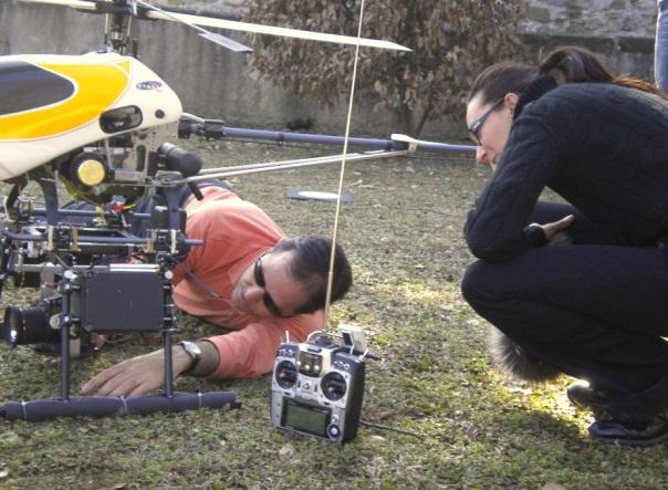
26 UNCONTROLLED FLIGHT PANORAMIC IMAGE ACQUISITION 26 For landscape reconstruction of priviledged ancient view points of a strategic hystoric area and landscape context


27 Helicopter platform Equipment RC helicopter versus UAV platform implementation

 20 mm Sigma lens Camera")
28 Helicopter platform: equipment Mount for camera orientation Radio controller: - Camera live view - Camera orientation - Image acquisitions Nikon D90 (4288x2848 px) 20 mm Sigma lens Camera Stabilizer


29 29
 -The 360 flight (Landscape Panoramic")
 on the top of a small hill with a dominant horizontal extension; 25")
 with a 20 mm Sigma lens; The average height ca 14 m.")
30 Flight test and Panoramic RC/UAV images: data processing critical aspects -The flight test site (nadir image on the panoramic hill) -The 360 flight (Landscape Panoramic oblique images) The flight test site (nadir image on the panoramic hill) Oggiono (Lombardy, Italy) on the top of a small hill with a dominant horizontal extension; 25 Image acquired with a high overlap; 20 targets placed on the ground; calibrated Nikon D90 (4288x2848 px) with a 20 mm Sigma lens; The average height ca 14 m. Products: DEM and Panoramic Image

: - 25 image block -")


31 Nadiral images orientation and DEM extraction Automatic SW ATiPE (Barazzetti et. All 2010): - 25 image block - using 20 target point ground signalized - using SIFT features automatically extracted for several combinations of image pairs; - 9 GCPs in the bundle adjustment, 11ChkPs RMSE 5 mm (x-y) and 17 mm (z).
32 The 360 flight test (Landscape Panoramic oblique images) UAV flight panoramic image acquisition for landscape reconstruction of priviledged ancient view points of the strategic hystoric area 32

33 The 360 flight test (Landscape Panoramic oblique images) UAV flight panoramic image acquisition for landscape reconstruction of priviledged ancient view points of the strategic hystoric area 33
34 Panoramic image generated by combining different pinhole shots markerless


35 35

36 36
Some Notes on Using Balloon Photography For Modeling the Landslide Area
 Some Notes on Using Balloon Photography For Modeling the Landslide Area Catur Aries Rokhmana Department of Geodetic-Geomatics Engineering Gadjah Mada University Grafika No.2 Yogyakarta 55281 - Indonesia
The power of virtual globes for valorising cultural heritage and enabling sustainable tourism: NASA World Wind applications
 The power of virtual globes for valorising cultural heritage and enabling sustainable tourism: NASA World Wind applications Maria Antonia Brovelli*, Patrick Hogan**, Marco Minghini*, Giorgio Zamboni* *
TESTFIELD TRENTO: GEOMETRIC EVALUATION OF VERY HIGH RESOLUTION SATELLITE IMAGERY
 TESTFIELD TRENTO: GEOMETRIC EVALUATION OF VERY HIGH RESOLUTION SATELLITE IMAGERY G. AGUGIAROa, D. POLIb, F. REMONDINOa, 3DOM, 3D Optical Metrology Unit Bruno Kessler Foundation, Trento, Italy a b Vermessung
The territory of ancient Caere
 Patrizia Tartara : The territory of ancient Caere Patrizia Tartara The territory of ancient Caere Consiglio Nazionale delle Ricerche, Istituto di Analisi dei Sistemi e Informatica Antonio Ruberti (IASI),
SCIENCE & TECHNOLOGY
 Pertanika J. Sci. & Technol. 21 (2): 387-396 (2013) SCIENCE & TECHNOLOGY Journal homepage: http://www.pertanika.upm.edu.my/ Production of Orthophoto and Volume Determination Using Low-Cost Digital Cameras
UAV PHOTOGRAMMETRY COMPARED TO TRADITIONAL RTK GPS SURVEYING
 UAV PHOTOGRAMMETRY COMPARED TO TRADITIONAL RTK GPS SURVEYING Brad C. Mathison and Amber Warlick March 20, 2016 Fearless Eye Inc. Kansas City, Missouri www.fearlesseye.com KEY WORDS: UAV, UAS, Accuracy
Validation of the QuestUAV PPK System
 Validation of the QuestUAV PPK System 3cm in xy, 400ft, no GCPs, 100Ha, 25 flights Nigel King 1, Kerstin Traut 2, Cameron Weeks 3 & Ruairi Hardman 4 1 Director QuestUAV, 2 Data Analyst QuestUAV, 3 Production
SPOT6. Impact of Spot 6 and 7 in the Constitution and Update of Spatial Data Infrastructures over Africa
 Astrium Services 2012 SPOT6 Impact of Spot 6 and 7 in the Constitution and Update of Spatial Data Infrastructures over Africa K. Guérin, M. Bernard, T. Rousselin, B. Navaro, J. Korona 26 th International
Govt. Engineering College Jhalawar Model Question Paper Subject- Remote Sensing & GIS
 Govt. Engineering College Jhalawar Model Question Paper Subject- Remote Sensing & GIS Time: Max. Marks: Q1. What is remote Sensing? Explain the basic components of a Remote Sensing system. Q2. What is
Sample Copy. Not For Distribution.
 Photogrammetry, GIS & Remote Sensing Quick Reference Book i EDUCREATION PUBLISHING Shubham Vihar, Mangla, Bilaspur, Chhattisgarh - 495001 Website: www.educreation.in Copyright, 2017, S.S. Manugula, V.
not to be republished NCERT Introduction To Aerial Photographs Chapter 6
 Chapter 6 Introduction To Aerial Photographs Figure 6.1 Terrestrial photograph of Mussorrie town of similar features, then we have to place ourselves somewhere in the air. When we do so and look down,
Black Dot shows actual Point location
 207 Plate 1 Use of scanned archive aerial photographs, digital photogrammetry and GIS to plot river channel erosion along the Afon Trannon, Wales (part of the study by Mount et al 2000, 2003). Plate 2
ROLE OF SATELLITE DATA APPLICATION IN CADASTRAL MAP AND DIGITIZATION OF LAND RECORDS DR.T. RAVISANKAR GROUP HEAD (LRUMG) RSAA/NRSC/ISRO /DOS HYDERABAD
 RSAA/NRSC/ISRO /DOS HYDERABAD") ROLE OF SATELLITE DATA APPLICATION IN CADASTRAL MAP AND DIGITIZATION OF LAND RECORDS DR.T. RAVISANKAR GROUP HEAD (LRUMG) RSAA/NRSC/ISRO /DOS HYDERABAD WORKSHOP on Best Practices under National Land Records
ROLE OF SATELLITE DATA APPLICATION IN CADASTRAL MAP AND DIGITIZATION OF LAND RECORDS DR.T. RAVISANKAR GROUP HEAD (LRUMG) RSAA/NRSC/ISRO /DOS HYDERABAD WORKSHOP on Best Practices under National Land Records
Time-Lapse Panoramas for the Egyptian Heritage
 Time-Lapse Panoramas for the Egyptian Heritage Mohammad NABIL Anas SAID CULTNAT, Bibliotheca Alexandrina While laser scanning and Photogrammetry has become commonly-used methods for recording historical
RESEARCH ON LOW ALTITUDE IMAGE ACQUISITION SYSTEM
 RESEARCH ON LOW ALTITUDE IMAGE ACQUISITION SYSTEM 1, Hongxia Cui, Zongjian Lin, Jinsong Zhang 3,* 1 Department of Information Science and Engineering, University of Bohai, Jinzhou, Liaoning Province,11,
Autonomous and Autonomic Systems: With Applications to NASA Intelligent Spacecraft Operations and Exploration Systems
 Walt Truszkowski, Harold L. Hallock, Christopher Rouff, Jay Karlin, James Rash, Mike Hinchey, and Roy Sterritt Autonomous and Autonomic Systems: With Applications to NASA Intelligent Spacecraft Operations
MSB Imagery Program FAQ v1
 MSB Imagery Program FAQ v1 (F)requently (A)sked (Q)uestions 9/22/2016 This document is intended to answer commonly asked questions related to the MSB Recurring Aerial Imagery Program. Table of Contents
APPLICATION OF STRUCTURE FROM MORTION IN JAPANESE ARCHAEOLOGY
 APPLICATION OF STRUCTURE FROM MORTION IN JAPANESE ARCHAEOLOGY Akihiro Kaneda A, *, Yama Ahmad Nawabi B, Hiroshi Yamaguchi C. A Nara National Research Institute for Cultural Properties, Center for Archaeological
Marco Cavallo. Merging Worlds: A Location-based Approach to Mixed Reality. Marco Cavallo Master Thesis Presentation POLITECNICO DI MILANO
 Marco Cavallo Merging Worlds: A Location-based Approach to Mixed Reality Marco Cavallo Master Thesis Presentation POLITECNICO DI MILANO Introduction: A New Realm of Reality 2 http://www.samsung.com/sg/wearables/gear-vr/
1.1 Students know how to use maps, globes, and other geographic tools to acquire, process, and report information from a spatial perspective.
 Prentice Hall World Geography: Building a Global Perspective 2005 Colorado Model Academic Standards for Social Studies: Geography (Grades 9-12) GEOGRAPHY STANDARD 1: Students know how to use and construct
Spatial Information in the Era of Data Science: Challenges and Practical Solutions
 Dear Colleagues and Friends, Please allow me to invite you to the Annual Workshop and Meeting of FIG Commission 3, organized in joint with the Consiglio Nazionale Geometri e Geometri Laureati, the Collegio
Module 4, Investigation 2: Log 1 What features do archaeologists look for on an image?
 What are the seven elements used by geoarchaeologists to analyze and interpret remotely sensed images? Geoarchaeologists face several issues when using remotely sensed images. They must determine the location
11/25/2009 CHAPTER THREE INTRODUCTION INTRODUCTION (CONT D) THE AERIAL CAMERA: LENS PHOTOGRAPHIC SENSORS
 THE AERIAL CAMERA: LENS PHOTOGRAPHIC SENSORS") INTRODUCTION CHAPTER THREE IC SENSORS Photography means to write with light Today s meaning is often expanded to include radiation just outside the visible spectrum, i. e. ultraviolet and near infrared
INTRODUCTION CHAPTER THREE IC SENSORS Photography means to write with light Today s meaning is often expanded to include radiation just outside the visible spectrum, i. e. ultraviolet and near infrared
sensefly Camera Collection
 Camera Collection A professional sensor for every application Introducing S.O.D.A. 3D 3D mapping, redefined Image: S.O.D.A. 3D oblique image (left) merging into 3D mesh (right). Stunning digital 3D reconstructions
Where Do Tourists Go? Visualizing and Analyzing the Spatial Distribution of Geotagged Photography
 Kádár & Gede: Where do tourists go? ICC 2013ICC Dresden, 2013 Dresden, 2012.08.25 30 2012.08.25 30 1/15 Where Do Tourists Go? Visualizing and Analyzing the Spatial Distribution of Geotagged Photography
Genealogical research h& local history
 Genealogical research h& local history Our experience as Associazione Genealogica Lombarda L Associazione Genealogica Lombarda Historical backgrounds of our association its organization and its local settings
9/13/2011. Training Course Remote Sensing Basic Theory & Image Processing Methods September 2011
 Training Course Remote Sensing Basic Theory & Image Processing Methods 19 23 September 2011 DIGITAL TERRAIN MODELS Introduction Michiel Damen (April 2011) damen@itc.nl 1 Digital Elevation and Terrain Models
Photogrammetry. Lecture 4 September 7, 2005
 Photogrammetry Lecture 4 September 7, 2005 What is Photogrammetry Photogrammetry is the art and science of making accurate measurements by means of aerial photography: Analog photogrammetry (using films:
Integrated Data Handling and Visualization
 Integrated Data Handling and Visualization Module of Remote Sensing and GIS Integration Course 2017 Lammert Kooistra, Ron van Lammeren, John Stuiver Environmental Resource Management in the Anthropocene
Unmanned Aerial Vehicle Data Acquisition for Damage Assessment in. Hurricane Events
 Unmanned Aerial Vehicle Data Acquisition for Damage Assessment in Hurricane Events Stuart M. Adams a Carol J. Friedland b and Marc L. Levitan c ABSTRACT This paper examines techniques for data collection
Appendix 8.2 Information to be Read in Conjunction with Visualisations
 Shepherds Rig Wind Farm EIA Report Appendix 8.2 Information to be Read in Conjunction with Visualisations Contents Contents i Introduction 1 Viewpoint Photography 1 Stitching of Panoramas and Post-Photographic
USE OF IMPROVISED REMOTELY SENSED DATA FROM UAV FOR GIS AND MAPPING, A CASE STUDY OF GOMA CITY, DR CONGO
 USE OF IMPROVISED REMOTELY SENSED DATA FROM UAV FOR GIS AND MAPPING, A CASE STUDY OF GOMA CITY, DR CONGO Cung Chin Thang United Nations Global Support Center, Brindisi, Italy, Email: thang@un.org KEY WORDS:
10. Real Time Mapping System INTRODUCTION REALTIME VOLCANO ACTIVITY MAPPING SYSTEM WITH GROUND FIXED SINGLE DIGITAL CAMERA
 10. Real Time System Real Time Road Object from Mobile Vehicle Real Time Position/Target Identification Minimum Accuracy but Enough Response Time Dynamic Phenomena Mobile Platform Current Topics Real Time
A (very) brief introduction to Remote Sensing: From satellites to maps!
 brief introduction to Remote Sensing: From satellites to maps!") Spatial Data Analysis and Modeling for Agricultural Development, with R - Workshop A (very) brief introduction to Remote Sensing: From satellites to maps! Earthlights DMSP 1994-1995 https://wikimedia.org/
Spatial Data Analysis and Modeling for Agricultural Development, with R - Workshop A (very) brief introduction to Remote Sensing: From satellites to maps! Earthlights DMSP 1994-1995 https://wikimedia.org/
Important Questions. Surveying Unit-II. Surveying & Leveling. Syllabus
 Surveying Unit-II Important Questions Define Surveying and Leveling Differentiate between Surveying and Leveling. Explain fundamental Principles of Surveying. Explain Plain and Diagonal Scale. What is
Coastal areas and land development. An algorithm for monitoring informal constructions An application in coastal areas. Informal building in Greece
 An algorithm for monitoring informal constructions An application in coastal areas Ch. Psaltis, Ch. Ioannidis Coastal areas and land development Coastal areas more developed than continental areas Overconcentration
UNIT 1 REVIEW SHEET FOUNDATIONS OF COMPLEX SOCIETIES: TECHNOLOGICAL & ENVIRONMENTAL TRANSFORMATIONS, TO 600 BCE
 Name: Due Date: UNIT 1 REVIEW SHEET FOUNDATIONS OF COMPLEX SOCIETIES: TECHNOLOGICAL & ENVIRONMENTAL TRANSFORMATIONS, TO 600 BCE PART 1: Content Review Part 1: Content Review You will define and explain
RAF DRAFT. Viewpoint 11: Taken from a road within Burlescombe, looking oking south-west towards the site.
 St. Mary s Church (Grade I listed) Viewpoint 11: Taken from a road within Burlescombe, looking oking south-west towards the site. RAF Approximate location of the site obscured by existing conifers FT Viewpoint
ASPECTS OF DEM GENERATION FROM UAS IMAGERY
 ASPECTS OF DEM GENERATION FROM UAS IMAGERY A. Greiwea,, R. Gehrke a,, V. Spreckels b,, A. Schlienkamp b, Department Architecture, Civil Engineering and Geomatics, Fachhochschule Frankfurt am Main, Germany
The National Library Service (SBN) towards Digital
 towards Digital") LIBER QUARTERLY, ISSN 1435-5205 LIBER 2003, All rights reserved K.G. Saur, Munich, printed in Germany The National Library Service (SBN) towards Digital by GIULIANA SGAMBATI INTRODUCTION In the sector
LIBER QUARTERLY, ISSN 1435-5205 LIBER 2003, All rights reserved K.G. Saur, Munich, printed in Germany The National Library Service (SBN) towards Digital by GIULIANA SGAMBATI INTRODUCTION In the sector
MINIMISING SYSTEMATIC ERRORS IN DEMS CAUSED BY AN INACCURATE LENS MODEL
 MINIMISING SYSTEMATIC ERRORS IN DEMS CAUSED BY AN INACCURATE LENS MODEL R. Wackrow a, J.H. Chandler a and T. Gardner b a Dept. Civil and Building Engineering, Loughborough University, LE11 3TU, UK (r.wackrow,
PERSPECTIVE VIEWS AND PANORAMAS IN PRESENTATION OF RELIEF FORMS IN POLAND
 PERSPECTIVE VIEWS AND PANORAMAS IN PRESENTATION OF RELIEF FORMS IN POLAND Waldemar Rudnicki Institute of Geodesy and Cartography, ul. Modzelewskiego 27, 02 679 Warsaw, Poland Tel: +48 22 3291993, Fax:
EVALUATION OF PLEIADES-1A TRIPLET ON TRENTO TESTFIELD
 EVALUATION OF PLEIADES-1A TRIPLET ON TRENTO TESTFIELD D. Poli a, F. Remondino b, E. Angiuli c, G. Agugiaro b a Terra Messflug GmbH, Austria b 3D Optical Metrology Unit, Fondazione Bruno Kessler, Trento,
Removing Thick Clouds in Landsat Images
 Removing Thick Clouds in Landsat Images S. Brindha, S. Archana, V. Divya, S. Manoshruthy & R. Priya Dept. of Electronics and Communication Engineering, Avinashilingam Institute for Home Science and Higher
9/12/2011. Training Course Remote Sensing Basic Theory & Image Processing Methods September 2011
 Training Course Remote Sensing Basic Theory & Image Processing Methods 19 23 September 2011 Introduction to Remote Sensing Michiel Damen (September 2011) damen@itc.nl 1 Overview Some definitions Remote
bhuvan Gateway to Indian Earth Observation Data Products & Services ISRO s Geoportal
 bhuvan ISRO s Geoportal Gateway to Indian Earth Observation Data Products & Services One-stop versatile Web based Earth Observation Data Products & Services Interactive 3D Environment Societal Applications
Title: How steep are those hills? Engineering Grade: Estimated Time: 3 hours (2 days) Groups: 3 to 4 students
 Groups: 3 to 4 students") Title: How steep are those hills? Engineering Grade: 10-12 Estimated Time: 3 hours (2 days) Groups: 3 to 4 students Synopsis: Students will be able to understand the concept of surveying and mapping ground
Title: How steep are those hills? Engineering Grade: 10-12 Estimated Time: 3 hours (2 days) Groups: 3 to 4 students Synopsis: Students will be able to understand the concept of surveying and mapping ground
Realistic Visual Environment for Immersive Projection Display System
 Realistic Visual Environment for Immersive Projection Display System Hasup Lee Center for Education and Research of Symbiotic, Safe and Secure System Design Keio University Yokohama, Japan hasups@sdm.keio.ac.jp
SENSITIVITY ANALYSIS OF UAV-PHOTOGRAMMETRY FOR CREATING DIGITAL ELEVATION MODELS (DEM)
") SENSITIVITY ANALYSIS OF UAV-PHOTOGRAMMETRY FOR CREATING DIGITAL ELEVATION MODELS (DEM) G. Rock a, *, J.B. Ries b, T. Udelhoven a a Dept. of Remote Sensing and Geomatics. University of Trier, Behringstraße,
SENSITIVITY ANALYSIS OF UAV-PHOTOGRAMMETRY FOR CREATING DIGITAL ELEVATION MODELS (DEM) G. Rock a, *, J.B. Ries b, T. Udelhoven a a Dept. of Remote Sensing and Geomatics. University of Trier, Behringstraße,
DECISION NUMBER FOURTEEN TO THE TREATY ON OPEN SKIES
 DECISION NUMBER FOURTEEN TO THE TREATY ON OPEN SKIES OSCC.DEC 14 12 October 1994 METHODOLOGY FOR CALCULATING THE MINIMUM HEIGHT ABOVE GROUND LEVEL AT WHICH EACH VIDEO CAMERA WITH REAL TIME DISPLAY INSTALLED
Comparison between SAR atmospheric phase screens at 30 by means of ERS and ENVISAT data
 Fringe 2007 - ESA-ESRIN - Frascati, November 28, 2007 Comparison between SAR atmospheric phase screens at 30 by means of ERS and ENVISAT data D. Perissin Politecnico di Milano Tele-Rilevamento Europa -
Aerial photography: Principles. Frame capture sensors: Analog film and digital cameras
 Aerial photography: Principles Frame capture sensors: Analog film and digital cameras Overview Introduction Frame vs scanning sensors Cameras (film and digital) Photogrammetry Orthophotos Air photos are
Metric Accuracy Testing with Mobile Phone Cameras
 Metric Accuracy Testing with Mobile Phone Cameras Armin Gruen,, Devrim Akca Chair of Photogrammetry and Remote Sensing ETH Zurich Switzerland www.photogrammetry.ethz.ch Devrim Akca, the 21. ISPRS Congress,
INDIRA GANDHI NATIONAL CENTRE FOR THE ARTS Janpath, New Delhi ,
 INDIRA GANDHI NATIONAL CENTRE FOR THE ARTS Janpath, New Delhi -110 001, www.ignca.gov.in Documentation format for Archaeological / Heritage Sites / Monuments Serial No.: RJ/KTP-26 1. Name SECTION I : IDENTIFICATION
LESSON 5. and the basic geometric shapes that form that building. You will be given the chance to compose your own elevation
 LESSON 5 Architecture is created from basic geometric shapes. In this lesson you will learn to identify those forms which compose the elevation of a building. When studying the elevation of a building,
SECTION I : IDENTIFICATION
 INDIRA GANDHI NATIONAL CENTRE FOR THE ARTS Janpath, New Delhi -110 001, www.ignca.gov.in Documentation format for Archaeological / Heritage Sites / Monuments Serial No.: OR / KDA/ BSR- 228 1. Name SECTION
UNISCAN AND ALICE-SC GROUND STATIONS AND DEVELOPMENT OF THEIR NETWORKS
 UNISCAN AND ALICE-SC GROUND STATIONS AND DEVELOPMENT OF THEIR NETWORKS Gershenzon V.E., Gershenzon O.N. R&D Center ScanEx Commission WG IV/9 KEY WORDS: Uniscan, Alice-SC, Stations, Geo-Portals ABSTRACT:
Application of Satellite Imagery for Rerouting Electric Power Transmission Lines
 Application of Satellite Imagery for Rerouting Electric Power Transmission Lines T. LUEMONGKOL 1, A. WANNAKOMOL 2 & T. KULWORAWANICHPONG 1 1 Power System Research Unit, School of Electrical Engineering
Case Study: Surveying an Intersection with a Bridge
 Case Study: Surveying an Intersection with a Bridge Date: January 2015 Location: Afula, Israel The Survey The required task was to survey and draft a 3D CAD plan of an intersection with a bridge, including
Volume 1 - Module 6 Geometry of Aerial Photography. I. Classification of Photographs. Vertical
 RSCC Volume 1 Introduction to Photo Interpretation and Photogrammetry Table of Contents Module 1 Module 2 Module 3.1 Module 3.2 Module 4 Module 5 Module 6 Module 7 Module 8 Labs Volume 1 - Module 6 Geometry
Geometry of Aerial Photographs
 Geometry of Aerial Photographs Aerial Cameras Aerial cameras must be (details in lectures): Geometrically stable Have fast and efficient shutters Have high geometric and optical quality lenses They can
Assessment of Unmanned Aerial Vehicle for Management of Disaster Information
 Journal of the Korea Academia-Industrial cooperation Society Vol. 16, No. 1 pp. 697-702, 2015 http://dx.doi.org/10.5762/kais.2015.16.1.697 ISSN 1975-4701 / eissn 2288-4688 Assessment of Unmanned Aerial
Digital Photography I: Creating Images with Impact v
 Digital Photography I: Creating Images with Impact v18 18-19 The Digital Photography I course focuses on the basics of photography, including building an understanding of aperture, shutter speed, lighting,
Venice: The Islands Of Murano, Burano And Trcello, And The Villas Of The Riviera Del Bre Nta (Tci Guides) By Italian Touring Club
 By Italian Touring Club") Venice: The Islands Of Murano, Burano And Trcello, And The Villas Of The Riviera Del Bre Nta (Tci Guides) By Italian Touring Club If you are searching for the ebook Venice: The Islands of Murano, Burano
Venice: The Islands Of Murano, Burano And Trcello, And The Villas Of The Riviera Del Bre Nta (Tci Guides) By Italian Touring Club If you are searching for the ebook Venice: The Islands of Murano, Burano
INDIRA GANDHI NATIONAL CENTRE FOR THE ARTS Janpath, New Delhi ,
 INDIRA GANDHI NATIONAL CENTRE FOR THE ARTS Janpath, New Delhi -110 001, www.ignca.gov.in Documentation format for Archaeological / Heritage Sites / Monuments Serial No.: OR/SNG - 12 1. Name SECTION I :
 Aquileia Forum The Aquileia Forum project is a cultural initiative that, using the most advanced technology of computergenerated virtual 3D representation, aims to bring the historical heritage of the
Q A bitmap file contains the binary on the left below. 1 is white and 0 is black. Colour in each of the squares. What is the letter that is reve
 R 25 Images and Pixels - Reading Images need to be stored and processed using binary. The simplest image format is for an image to be stored as a bitmap image. Bitmap images are made up of picture elements
Basics of Photogrammetry Note#6
 Basics of Photogrammetry Note#6 Photogrammetry Art and science of making accurate measurements by means of aerial photography Analog: visual and manual analysis of aerial photographs in hard-copy format
Main topic of research: creation of tree line map. Scale: LANDSAT imagery (15-30 m spatial resolution)
") «Usage of geoportal information for mapping the northern forest line boundary» Mikhail Zimin NINA (Trondheim, Norway) Volkovo village, Zvenigorod (Moscow region), RUSSIA, 14-1717 April, 2009 Introduction
«Usage of geoportal information for mapping the northern forest line boundary» Mikhail Zimin NINA (Trondheim, Norway) Volkovo village, Zvenigorod (Moscow region), RUSSIA, 14-1717 April, 2009 Introduction
VERIFICATION OF POTENCY OF AERIAL DIGITAL OBLIQUE CAMERAS FOR AERIAL PHOTOGRAMMETRY IN JAPAN
 VERIFICATION OF POTENCY OF AERIAL DIGITAL OBLIQUE CAMERAS FOR AERIAL PHOTOGRAMMETRY IN JAPAN Ryuji. Nakada a, *, Masanori. Takigawa a, Tomowo. Ohga a, Noritsuna. Fujii a a Asia Air Survey Co. Ltd., Kawasaki
THE ITALIAN RENAISSANCE. Chapter 19 AP Art History
 THE ITALIAN RENAISSANCE Chapter 19 AP Art History INSTRUCTIONAL OBJECTIVES: Students will be able to: Explore the development and use of linear perspective in 15 th Century Florentine painting. Examine
Introduction to Photogrammetry
 Introduction to Photogrammetry Presented By: Sasanka Madawalagama Geoinformatics Center Asian Institute of Technology Thailand www.geoinfo.ait.asia Content Introduction to photogrammetry 2D to 3D Drones
A New Capability for Crash Site Documentation
 A New Capability for Crash Site Documentation By Major Adam Cybanski, Directorate of Flight Safety, Ottawa Major Adam Cybanski is the officer responsible for helicopter investigation (DFS 2-4) at the Canadian
Digital Photogrammetry. Presented by: Dr. Hamid Ebadi
 Digital Photogrammetry Presented by: Dr. Hamid Ebadi Background First Generation Analog Photogrammetry Analytical Photogrammetry Digital Photogrammetry Photogrammetric Generations 2000 digital photogrammetry
CAN WE USE LOW-COST 360 DEGREE CAMERAS TO CREATE ACCURATE 3D MODELS?
 CAN WE USE LOW-COST 360 DEGREE CAMERAS TO CREATE ACCURATE 3D MODELS? L. Barazzetti 1, M. Previtali 1, F. Roncoroni 2 1 Dept. of Architecture, Built environment and Construction engineering (ABC) Politecnico
LAST GENERATION UAV-BASED MULTI- SPECTRAL CAMERA FOR AGRICULTURAL DATA ACQUISITION
 LAST GENERATION UAV-BASED MULTI- SPECTRAL CAMERA FOR AGRICULTURAL DATA ACQUISITION FABIO REMONDINO, Erica Nocerino, Fabio Menna Fondazione Bruno Kessler Trento, Italy http://3dom.fbk.eu Marco Dubbini,
Digital Photography I: Creating Images with Impact!
 Course Syllabus Digital Photography I: Creating Images with Impact! Course Description Have you ever wondered how photographers take such great pictures? Have you tried to take photographs and wondered
Satellite data processing and analysis: Examples and practical considerations
 Satellite data processing and analysis: Examples and practical considerations Dániel Kristóf Ottó Petrik, Róbert Pataki, András Kolesár International LCLUC Regional Science Meeting in Central Europe Sopron,
Factors that affect the accuracy of UAS surveys
 Factors that affect the accuracy of UAS surveys Dr. Dimitrios Bolkas; dxb80@psu.edu Department of Surveying Engineering, Pennsylvania State University, Wilkes-Barre Campus PSLS Surveyor s Conference Hershey,
Following are the geometrical elements of the aerial photographs:
 Geometrical elements/characteristics of aerial photograph: An aerial photograph is a central or perspective projection, where the bundles of perspective rays meet at a point of origin called perspective
Digital Photography I: Creating Images with Impact!
 Course Syllabus Digital Photography I: Creating Images with Impact! Course Code: EDL014 Course Description Have you ever wondered how professional photographers manage to take such sensational pictures?
Title of Lesson: Egypt ~ Hot Off The Press Date: June 1, WACH Trip or Workshop:
 Title of Lesson: Date: June 1, 2008 Author(s): Mary Reed Grade/Level: 9th Subject Area: PreAP World Geography WACH Trip or Workshop: Egypt March 2008 Component Detail Materials/Resources TEKS (Texas Essential
Overview. Introduction. Elements of Image Interpretation. LA502 Special Studies Remote Sensing
 LA502 Special Studies Remote Sensing Elements of Image Interpretation Dr. Ragab Khalil Department of Landscape Architecture Faculty of Environmental Design King AbdulAziz University Room 103 Overview Introduction
The tanning industry in Solofra THE GOLDEN YEARS. Society, economy and territory in 16th-century Solofra
 The tanning industry in Solofra THE GOLDEN YEARS Society, economy and territory in 16th-century Solofra A. Cogliano, M. De Maio, M. Sammarco, L. De Venezia, A. De Blasi Abstract The Objectives The Historic
Technical information about PhoToPlan
 Technical information about PhoToPlan The following pages shall give you a detailed overview of the possibilities using PhoToPlan. kubit GmbH Fiedlerstr. 36, 01307 Dresden, Germany Fon: +49 3 51/41 767
Activities for Culture and Tourism
 The Concept Activities for Culture and Tourism The role and commitment of the government is to promote the vision and land management as a unified cultural area and highly interconnected. Among the many
Aral Sea profile Selection of area 24 February April May 1998
 250 km Aral Sea profile 1960 1960 1985 1986 1987 1988 1989 1990 1991 1992 1993 1994 1995 1996 1997 1998 2010? Selection of area Area of interest Kzyl-Orda Dried seabed 185 km Syrdarya river Aral Sea Salt
DETERMINATION OF ST. GEORGE BASILICA TOWER HISTORICAL INCLINATION FROM CONTEMPORARY PHOTOGRAPH
 DETERMINATION OF ST. GEORGE BASILICA TOWER HISTORICAL INCLINATION FROM CONTEMPORARY PHOTOGRAPH Bronislav KOSKA 1 1 Czech Technical University in Prague, Faculty of Civil Engineering Thákurova 7, Prague
Film Cameras Digital SLR Cameras Point and Shoot Bridge Compact Mirror less
 Film Cameras Digital SLR Cameras Point and Shoot Bridge Compact Mirror less Portraits Landscapes Macro Sports Wildlife Architecture Fashion Live Music Travel Street Weddings Kids Food CAMERA SENSOR
Application of GIS to Fast Track Planning and Monitoring of Development Agenda
 Application of GIS to Fast Track Planning and Monitoring of Development Agenda Radiometric, Atmospheric & Geometric Preprocessing of Optical Remote Sensing 13 17 June 2018 Outline 1. Why pre-process remotely
3.0 AFFECTED ENVIRONMENT
 3.0 AFFECTED ENVIRONMENT 3.1 Visual Resources This section provides a discussion of the existing visual resources in the vicinity of the Imperial Valley Solar Energy Center South project site that could
Urban Classification of Metro Manila for Seismic Risk Assessment using Satellite Images
 Urban Classification of Metro Manila for Seismic Risk Assessment using Satellite Images Fumio YAMAZAKI/ yamazaki@edm.bosai.go.jp Hajime MITOMI/ mitomi@edm.bosai.go.jp Yalkun YUSUF/ yalkun@edm.bosai.go.jp
Chapter 1 Overview of imaging GIS
 Chapter 1 Overview of imaging GIS Imaging GIS, a term used in the medical imaging community (Wang 2012), is adopted here to describe a geographic information system (GIS) that displays, enhances, and facilitates
INSERTING THE PAST IN VIDEO SEQUENCES
 INSERTING THE PAST IN VIDEO SEQUENCES Elli Petsa, Stefanos Kouroupis Department of Surveying, Technological Educational Institute of Athens GR-12210 Athens, Greece (e-mail: petsa@teiath.gr) George Karras
UNIVERSITY OF CAMBRIDGE INTERNATIONAL EXAMINATIONS Cambridge International Level 3 Pre-U Certificate Principal Subject
 UNIVERSITY OF CAMBRIDGE INTERNATIONAL EXAMINATIONS Cambridge International Level 3 Pre-U Certificate Principal Subject *2535807504* ART HISTORY 9799/03 Paper 3 Thematic Topics May/June 2013 Additional
Virtual Environments...
 Introducing Virtual Travel.... Virtual Environments....2 Moving Past the Picture Frame....3 Being Not-There May Be More Achievable....4 Being Not-There May Safeguard the Place....5 Share by Being Not-There....6
The Hyperspectral UAV (HyUAV) a novel UAV-based spectroscopy tool for environmental monitoring
 a novel UAV-based spectroscopy tool for environmental monitoring") The Hyperspectral UAV (HyUAV) a novel UAV-based spectroscopy tool for environmental monitoring R. Garzonio 1, S. Cogliati 1, B. Di Mauro 1, A. Zanin 2, B. Tattarletti 2, F. Zacchello 2, P. Marras 2 and
The Hyperspectral UAV (HyUAV) a novel UAV-based spectroscopy tool for environmental monitoring R. Garzonio 1, S. Cogliati 1, B. Di Mauro 1, A. Zanin 2, B. Tattarletti 2, F. Zacchello 2, P. Marras 2 and
toponymy course: Fieldwork Ferjan Ormeling 23/03/2018
 toponymy course: Fieldwork Ferjan Ormeling 1 2014 2 3 Fieldwork objectives Identify local landmarks/features referred to by people in their day-to-day conversation Record well-established names for these
Context-Aware Interaction in a Mobile Environment
 Context-Aware Interaction in a Mobile Environment Daniela Fogli 1, Fabio Pittarello 2, Augusto Celentano 2, and Piero Mussio 1 1 Università degli Studi di Brescia, Dipartimento di Elettronica per l'automazione
Remote sensing image correction
 Remote sensing image correction Introductory readings remote sensing http://www.microimages.com/documentation/tutorials/introrse.pdf 1 Preprocessing Digital Image Processing of satellite images can be