Digital Photogrammetry. Presented by: Dr. Hamid Ebadi
|
|
|
- Rosaline Moore
- 5 years ago
- Views:
Transcription
1 Digital Photogrammetry Presented by: Dr. Hamid Ebadi
2 Background First Generation Analog Photogrammetry Analytical Photogrammetry Digital Photogrammetry
3 Photogrammetric Generations 2000 digital photogrammetry 1950 analytical photogrammetry analog photogrammetry 1900 first generation 1850

4 Computer Generations and Photogrammetric Discipline Generation Hardware Software Photogrammetric Discipline 1 -Vacuum tubes -machine code 2 3 -transistors -magnetic core memory -IC memory -minicomputers -mag.disk storage -higher level languages (FORTRAN-COBOL) -time sharing -operating systems -Virtual memory - analytical photogrammetry -aerial triangulation -correlation -analytical plotter 4 -Microprocessors, PC -VLSI -networking -new languages -(PASCAL-MODULA) -IGS, DBMS Computer-assisted photogrammetry 5 -parallel processing -RISC architecture -VHSIC -optical disk storage -knowledge based SW -expert systems - natural language processing -digital photogrammetry -real-time photogrammetry
5 Terminology-Or the Lack Thereof
6 Generic Digital Photogrammetry Environment Photograph Scanner Digital Camera Digital Image Display Computer Storage User Interface Film Recorder orthophoto Plotter map
7 Properties of Digital Imagery Definition of Digital Image Spatial Resolution and Geometric Accuracy Radiometric Resolution
8 Definition of Digital Image Columns y M-1 0 y Pixel x 1 2 Rows photograph x N-1
9 Spatial Resolution and Geometric Accuracy Pixel Size(micron) Number of Pixels 240 * * * * * * * * Storage Requirement (MB)
10 Classification of Processes and Tasks in Digital Photogrammetry System Level Tasks Low Level Tasks Middle Level Tasks High Level Tasks
11 Classification of Processes and Tasks in Digital Photogrammetry Category Processes, Algorithms Tasks System level Low level Middle level High level Store, access, display, images Process, match images, extract features Group, segment images Understand images Manipulate digital imagery Image processing: orientations, digital orthophoto,, DEM, AT Surface reconstruction Feature reconstruction Object recognition Image interpretation

12 Relationship of Digital Photogrammetry to Other Discipline Digital image Processing Digital Image Computer Graphics Computer Vision Scene Description
13 Fundamentals of Digital Photogrammetry Why use Digital Images? Advantages of using Digital Images: Appropriate way for displaying and Measurement Stability Applying image Enhancement is possible Automation can be applied Real time phptogrammetry is not out of access
14 Characteristics of Digital Data Digitization Intensity Gray Value Density Sampling Quantization of gray levels Noise

15 Concept of Sampling

16 Theory of Sampling

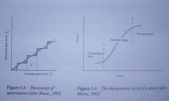
17 Concept of Quantization

18 Signal versus Noise
19 Charge Coupled Devices (CCDs( CCDs) Characteristics Size of the array Pixel size Dynamic range Geometric aspect (Lens Distortions) Transfer of Data from sensor to storage Time taken to record an image Pixel size and Resolution Spatial Radoimetric Spectral
20 Operations Enhancement Restoration Compression Classification Enhancement Image Processing Contrast Stretching Filtering Resampling
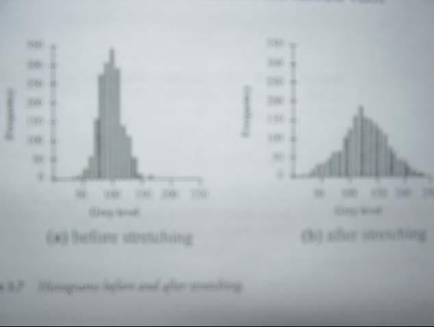
21 Contrast Stretching
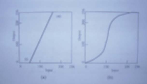
22 Contrast Stretching

23 Resampling of Digital Images
24 Data Acquisition CCD Cameras Scanners Drum Scanners Linear Arrays CCD Arrays Data Compression JPEG
25 Hardware for Digital Photogrammetry Basic Hardware Requirements High Resolution Display Flexible image memory with fast access for real time roaming Interface capability for scanners and cameras Interface with output devices Image enhancement processor 3D measurement with special control devices Subpixel accuracy Data capture in a GIS or CAD Stereoscopic Viewing Special Hardware requirements
26 Software Requirements for DP Standard Requirements: Handling Image Display Measurement Recording Pixel Coordinates Determination of Orientations Inner Orientation including Calibration parameters Relative and absolute orientations, Bundle Adjustment Transformations Image Processing Functions Image Matching Edge Detection Digital Rectification Visualization Automation
27 References T. Schenk, Digital Photogrammetry,, Terra Science, 1999 M. Kasser and W. Egels, Digital Photogrammetry,, Taylor and Francis, 2002 H. Ebadi, Advanced Analytical Aerial Triangulation,, Lecture Note, K.N.Toosi University of Technology, 1999 T.C.Tang, Digital Image Correlation, UCSEm Report, 1988
Aerial photography: Principles. Frame capture sensors: Analog film and digital cameras
 Aerial photography: Principles Frame capture sensors: Analog film and digital cameras Overview Introduction Frame vs scanning sensors Cameras (film and digital) Photogrammetry Orthophotos Air photos are
switzerland Commission II, ISPRS Kyoto, July 1988
 TOWARDS THE DIGITAL FUTURE stefan Lutz Kern & CO.., Ltd 5000 Aarau switzerland Commission II, ISPRS Kyoto, July 1988 ABSTRACT The equipping of the Kern Digital stereo Restitution Instrument (DSR) with
DEVELOPMENT OF IMAGE-BASED INFORMATION SYSTEM FOR RESTORATION OF CULTURAL HERITAGE
 Hongo, Kenji DEVELOPMENT OF IMAGE-BASED INFORMATION SYSTEM FOR RESTORATION OF CULTURAL HERITAGE Kenji Hongo*, Ryuji Matsuoka*, Seiju Fujiwara*, Katsuhiko Masuda** and Shigeo Aoki** * Kokusai Kogyo Co.,
GE 113 REMOTE SENSING
 GE 113 REMOTE SENSING Topic 5. Introduction to Digital Image Interpretation and Analysis Lecturer: Engr. Jojene R. Santillan jrsantillan@carsu.edu.ph Division of Geodetic Engineering College of Engineering
Chapters 1-3. Chapter 1: Introduction and applications of photogrammetry Chapter 2: Electro-magnetic radiation. Chapter 3: Basic optics
 Chapters 1-3 Chapter 1: Introduction and applications of photogrammetry Chapter 2: Electro-magnetic radiation Radiation sources Classification of remote sensing systems (passive & active) Electromagnetic
An Introduction to Geomatics. Prepared by: Dr. Maher A. El-Hallaq خاص بطلبة مساق مقدمة في علم. Associate Professor of Surveying IUG
 An Introduction to Geomatics خاص بطلبة مساق مقدمة في علم الجيوماتكس Prepared by: Dr. Maher A. El-Hallaq Associate Professor of Surveying IUG 1 Airborne Imagery Dr. Maher A. El-Hallaq Associate Professor
SECTION I - CHAPTER 2 DIGITAL IMAGING PROCESSING CONCEPTS
 RADT 3463 - COMPUTERIZED IMAGING Section I: Chapter 2 RADT 3463 Computerized Imaging 1 SECTION I - CHAPTER 2 DIGITAL IMAGING PROCESSING CONCEPTS RADT 3463 COMPUTERIZED IMAGING Section I: Chapter 2 RADT
Images and Graphics. 4. Images and Graphics - Copyright Denis Hamelin - Ryerson University
 Images and Graphics Images and Graphics Graphics and images are non-textual information that can be displayed and printed. Graphics (vector graphics) are an assemblage of lines, curves or circles with
KEY WORDS: Animation, Architecture, Image Rectification, Multi-Media, Texture Mapping, Visualization
 AUTOMATED PROCESSING OF DIGITAL IMAGE DATA IN ARCHITECTURAL SURVEYING Günter Pomaska Prof. Dr.-Ing., Faculty of Architecture and Civil Engineering FH Bielefeld, University of Applied Sciences Artilleriestr.
D. Hunter, J. Smart Kern & Co.., Ltd 5000 Aarau switzerland Commission II, ISPRS Kyoto, July 1988
 IMAGE ORIENTATION ON THE KERN DSR D. Hunter, J. Smart Kern & Co.., Ltd 5000 Aarau switzerland Commission II, ISPRS Kyoto, July 1988 Abstract A description of the possible image orientation capabilities
Technical Evaluation of Khartoum State Mapping Project
 Technical Evaluation of Khartoum State Mapping Project Nagi Zomrawi 1 and Mohammed Fator 2 1 School of Surveying Engineering, Collage of Engineering, Sudan University of Science and Technology, Khartoum,
SE 464. Introduction to Digital Photogrammetry
 SE 464 Introduction to Digital Photogrammetry ١ Introduction Digital photogrammetry is a generic description of a new form of photogrammetry based on digital (softcopy) images, as distinct from conventional
Sample Copy. Not For Distribution.
 Photogrammetry, GIS & Remote Sensing Quick Reference Book i EDUCREATION PUBLISHING Shubham Vihar, Mangla, Bilaspur, Chhattisgarh - 495001 Website: www.educreation.in Copyright, 2017, S.S. Manugula, V.
ENHANCEMENT OF THE RADIOMETRIC IMAGE QUALITY OF PHOTOGRAMMETRIC SCANNERS.
 ENHANCEMENT OF THE RADIOMETRIC IMAGE QUALITY OF PHOTOGRAMMETRIC SCANNERS Klaus NEUMANN *, Emmanuel BALTSAVIAS ** * Z/I Imaging GmbH, Oberkochen, Germany neumann@ziimaging.de ** Institute of Geodesy and
Leica ADS80 - Digital Airborne Imaging Solution NAIP, Salt Lake City 4 December 2008
 Luzern, Switzerland, acquired at 5 cm GSD, 2008. Leica ADS80 - Digital Airborne Imaging Solution NAIP, Salt Lake City 4 December 2008 Shawn Slade, Doug Flint and Ruedi Wagner Leica Geosystems AG, Airborne
Desktop - Photogrammetry and its Link to Web Publishing
 Desktop - Photogrammetry and its Link to Web Publishing Günter Pomaska FH Bielefeld, University of Applied Sciences Bielefeld, Germany, email gp@imagefact.de Key words: Photogrammetry, image refinement,
DSW700 System Description
 DSW700 Technical Details Overview Softcopy photogrammetry work, stereo-compilation, and ultimately, orthophotos can only be as accurate as the source imagery. Working in a digital photogrammetry environment
Photogrammetry. Lecture 4 September 7, 2005
 Photogrammetry Lecture 4 September 7, 2005 What is Photogrammetry Photogrammetry is the art and science of making accurate measurements by means of aerial photography: Analog photogrammetry (using films:
Image acquisition. In both cases, the digital sensing element is one of the following: Line array Area array. Single sensor
 Image acquisition Digital images are acquired by direct digital acquisition (digital still/video cameras), or scanning material acquired as analog signals (slides, photographs, etc.). In both cases, the
DIGITAL IMAGING. Handbook of. Wiley VOL 1: IMAGE CAPTURE AND STORAGE. Editor-in- Chief
 Handbook of DIGITAL IMAGING VOL 1: IMAGE CAPTURE AND STORAGE Editor-in- Chief Adjunct Professor of Physics at the Portland State University, Oregon, USA Previously with Eastman Kodak; University of Rochester,
Digital Image Processing
 Digital Image Processing 1 Patrick Olomoshola, 2 Taiwo Samuel Afolayan 1,2 Surveying & Geoinformatic Department, Faculty of Environmental Sciences, Rufus Giwa Polytechnic, Owo. Nigeria Abstract: This paper
A Study for Choosing The Best Pixel Surveying Method by Using Pixel Decision Structures in Satellite Images
 A Study for Choosing The est Pixel Surveying Method by Using Pixel Decision Structures in Satellite Images Seyyed Emad MUSAVI and Amir AUHAMZEH Key words: pixel processing, pixel surveying, image processing,
ROBOT VISION. Dr.M.Madhavi, MED, MVSREC
 ROBOT VISION Dr.M.Madhavi, MED, MVSREC Robotic vision may be defined as the process of acquiring and extracting information from images of 3-D world. Robotic vision is primarily targeted at manipulation
ECC419 IMAGE PROCESSING
 ECC419 IMAGE PROCESSING INTRODUCTION Image Processing Image processing is a subclass of signal processing concerned specifically with pictures. Digital Image Processing, process digital images by means
AUTOMATED PROCESSING OF DIGITAL IMAGE DATA IN ARCHITECTURAL SURVEYING
 International Archives of Photogrammetry and Remote Sensing. Vol. XXXII, Part 5. Hakodate 1998 AUTOMATED PROCESSING OF DIGITAL IMAGE DATA IN ARCHITECTURAL SURVEYING Gunter Pomaska Prof. Dr.-lng., Faculty
EC-433 Digital Image Processing
 EC-433 Digital Image Processing Lecture 2 Digital Image Fundamentals Dr. Arslan Shaukat 1 Fundamental Steps in DIP Image Acquisition An image is captured by a sensor (such as a monochrome or color TV camera)
Lecture 3 Digital image processing.
 Lecture 3 Digital image processing. MI_L3 1 Analog image digital image 2D image matrix of pixels scanner reflection mode analog-to-digital converter (ADC) digital image MI_L3 2 The process of converting
Background. Computer Vision & Digital Image Processing. Improved Bartlane transmitted image. Example Bartlane transmitted image
 Background Computer Vision & Digital Image Processing Introduction to Digital Image Processing Interest comes from two primary backgrounds Improvement of pictorial information for human perception How
Product Description. Leica DSW700 Digital Scanning Workstation
 Product Description Leica DSW700 Digital Scanning Workstation TM 1 Overview Softcopy photogrammetry work, stereo-compilation, and ultimately, orthophotos can only be as accurate as the source imagery.
Geometry perfect Radiometry unknown?
 Institut für Photogrammetrie Geometry perfect Radiometry unknown? Photogrammetric Week 2011 Stuttgart Michael Cramer Institut für Photogrammetrie () Universität Stuttgart michael.cramer@.uni-stuttgart.de
What is Photogrammetry
 Photogrammetry What is Photogrammetry Photogrammetry is the art and science of making accurate measurements by means of aerial photography: Analog photogrammetry (using films: hard-copy photos) Digital
High Resolution Sensor Test Comparison with SPOT, KFA1000, KVR1000, IRS-1C and DPA in Lower Saxony
 High Resolution Sensor Test Comparison with SPOT, KFA1000, KVR1000, IRS-1C and DPA in Lower Saxony K. Jacobsen, G. Konecny, H. Wegmann Abstract The Institute for Photogrammetry and Engineering Surveys
Digital image processing. Árpád BARSI BME Dept. Photogrammetry and Geoinformatics
 Digital image processing Árpád BARSI BME Dept. Photogrammetry and Geoinformatics barsi.arpad@epito.bme.hu Part 1: (5/12/) Theory of image processing Part 2: (12/12/) Practice with software examples Main
TELLS THE NUMBER OF PIXELS THE TRUTH? EFFECTIVE RESOLUTION OF LARGE SIZE DIGITAL FRAME CAMERAS
 TELLS THE NUMBER OF PIXELS THE TRUTH? EFFECTIVE RESOLUTION OF LARGE SIZE DIGITAL FRAME CAMERAS Karsten Jacobsen Leibniz University Hannover Nienburger Str. 1 D-30167 Hannover, Germany jacobsen@ipi.uni-hannover.de
GROUND CONTROL POINTS ACQUISITION USING SPOT IMAGE - THE OPERATIONAL COMPARISON
 GROUND CONTROL POINTS ACQUISITION USING SPOT IMAGE - THE OPERATIONAL COMPARISON Kim Kam-Lae *, Chun Ho-Woun **, Lee, Ho-Nam *** * Professor, Myongji University, KOREA ** Senior Researcher, Seoul National
Introduction. Prof. Lina Karam School of Electrical, Computer, & Energy Engineering Arizona State University
 EEE 508 - Digital Image & Video Processing and Compression http://lina.faculty.asu.edu/eee508/ Introduction Prof. Lina Karam School of Electrical, Computer, & Energy Engineering Arizona State University
Digital Image Processing
 What is an image? Digital Image Processing Picture, Photograph Visual data Usually two- or three-dimensional What is a digital image? An image which is discretized, i.e., defined on a discrete grid (ex.
CS 548: Computer Vision REVIEW: Digital Image Basics. Spring 2016 Dr. Michael J. Reale
 CS 548: Computer Vision REVIEW: Digital Image Basics Spring 2016 Dr. Michael J. Reale Human Vision System: Cones and Rods Two types of receptors in eye: Cones Brightness and color Photopic vision = bright-light
Exercise questions for Machine vision
 Exercise questions for Machine vision This is a collection of exercise questions. These questions are all examination alike which means that similar questions may appear at the written exam. I ve divided
William B. Green, Danika Jensen, and Amy Culver California Institute of Technology Jet Propulsion Laboratory Pasadena, CA 91109
 DIGITAL PROCESSING OF REMOTELY SENSED IMAGERY William B. Green, Danika Jensen, and Amy Culver California Institute of Technology Jet Propulsion Laboratory Pasadena, CA 91109 INTRODUCTION AND BASIC DEFINITIONS
Vexcel Imaging GmbH Innovating in Photogrammetry: UltraCamXp, UltraCamLp and UltraMap
 Photogrammetric Week '09 Dieter Fritsch (Ed.) Wichmann Verlag, Heidelberg, 2009 Wiechert, Gruber 27 Vexcel Imaging GmbH Innovating in Photogrammetry: UltraCamXp, UltraCamLp and UltraMap ALEXANDER WIECHERT,
USE OF HISTOGRAM EQUALIZATION IN IMAGE PROCESSING FOR IMAGE ENHANCEMENT
 USE OF HISTOGRAM EQUALIZATION IN IMAGE PROCESSING FOR IMAGE ENHANCEMENT Sapana S. Bagade M.E,Computer Engineering, Sipna s C.O.E.T,Amravati, Amravati,India sapana.bagade@gmail.com Vijaya K. Shandilya Assistant
APPLICATION OF COMPUTER VISION FOR DETERMINATION OF SYMMETRICAL OBJECT POSITION IN THREE DIMENSIONAL SPACE
 APPLICATION OF COMPUTER VISION FOR DETERMINATION OF SYMMETRICAL OBJECT POSITION IN THREE DIMENSIONAL SPACE Najirah Umar 1 1 Jurusan Teknik Informatika, STMIK Handayani Makassar Email : najirah_stmikh@yahoo.com
Processing of stereo scanner: from stereo plotter to pixel factory
 Photogrammetric Week '03 Dieter Fritsch (Ed.) Wichmann Verlag, Heidelberg, 2003 Bignone 141 Processing of stereo scanner: from stereo plotter to pixel factory FRANK BIGNONE, ISTAR, France ABSTRACT With
UltraCam and UltraMap Towards All in One Solution by Photogrammetry
 Photogrammetric Week '11 Dieter Fritsch (Ed.) Wichmann/VDE Verlag, Belin & Offenbach, 2011 Wiechert, Gruber 33 UltraCam and UltraMap Towards All in One Solution by Photogrammetry ALEXANDER WIECHERT, MICHAEL
HIGH RESOLUTION COLOR IMAGERY FOR ORTHOMAPS AND REMOTE SENSING. Author: Peter Fricker Director Product Management Image Sensors
 HIGH RESOLUTION COLOR IMAGERY FOR ORTHOMAPS AND REMOTE SENSING Author: Peter Fricker Director Product Management Image Sensors Co-Author: Tauno Saks Product Manager Airborne Data Acquisition Leica Geosystems
APPLICATIONS AND LESSONS LEARNED WITH AIRBORNE MULTISPECTRAL IMAGING
 APPLICATIONS AND LESSONS LEARNED WITH AIRBORNE MULTISPECTRAL IMAGING James M. Ellis and Hugh S. Dodd The MapFactory and HJW Walnut Creek and Oakland, California, U.S.A. ABSTRACT Airborne digital frame
DEVELOPMENT AND APPLICATION OF AN EXTENDED GEOMETRIC MODEL FOR HIGH RESOLUTION PANORAMIC CAMERAS
 DEVELOPMENT AND APPLICATION OF AN EXTENDED GEOMETRIC MODEL FOR HIGH RESOLUTION PANORAMIC CAMERAS D. Schneider, H.-G. Maas Dresden University of Technology Institute of Photogrammetry and Remote Sensing
Model-Based Design for Sensor Systems
 2009 The MathWorks, Inc. Model-Based Design for Sensor Systems Stephanie Kwan Applications Engineer Agenda Sensor Systems Overview System Level Design Challenges Components of Sensor Systems Sensor Characterization
Practical Image and Video Processing Using MATLAB
 Practical Image and Video Processing Using MATLAB Chapter 1 Introduction and overview What will we learn? What is image processing? What are the main applications of image processing? What is an image?
GE 113 REMOTE SENSING. Topic 7. Image Enhancement
 GE 113 REMOTE SENSING Topic 7. Image Enhancement Lecturer: Engr. Jojene R. Santillan jrsantillan@carsu.edu.ph Division of Geodetic Engineering College of Engineering and Information Technology Caraga State
Some Enhancement in Processing Aerial Videography Data for 3D Corridor Mapping
 Some Enhancement in Processing Aerial Videography Data for 3D Corridor Mapping Catur Aries ROKHMANA, Indonesia Key words: 3D corridor mapping, aerial videography, point-matching, sub-pixel enhancement,
Leica - 3 rd Generation Airborne Digital Sensors Features / Benefits for Remote Sensing & Environmental Applications
 Leica - 3 rd Generation Airborne Digital Sensors Features / Benefits for Remote Sensing & Environmental Applications Arthur Rohrbach, Sensor Sales Dir Europe, Middle-East and Africa (EMEA) Luzern, Switzerland,
Principles of Photogrammetry
 Winter 2014 1 Instructor: Contact Information. Office: Room # ENE 229C. Tel: (403) 220-7105. E-mail: ahabib@ucalgary.ca Lectures (SB 148): Monday, Wednesday& Friday (10:00 a.m. 10:50 a.m.). Office Hours:
Digital Imaging Rochester Institute of Technology
 Digital Imaging 1999 Rochester Institute of Technology So Far... camera AgX film processing image AgX photographic film captures image formed by the optical elements (lens). Unfortunately, the processing
RGB colours: Display onscreen = RGB
 RGB colours: http://www.colorspire.com/rgb-color-wheel/ Display onscreen = RGB DIGITAL DATA and DISPLAY Myth: Most satellite images are not photos Photographs are also 'images', but digital images are
Remote Sensing. The following figure is grey scale display of SPOT Panchromatic without stretching.
 Remote Sensing Objectives This unit will briefly explain display of remote sensing image, geometric correction, spatial enhancement, spectral enhancement and classification of remote sensing image. At
remote sensing? What are the remote sensing principles behind these Definition
 Introduction to remote sensing: Content (1/2) Definition: photogrammetry and remote sensing (PRS) Radiation sources: solar radiation (passive optical RS) earth emission (passive microwave or thermal infrared
Digital Image Processing - A Remote Sensing Perspective
 ISSN 2278 0211 (Online) Digital Image Processing - A Remote Sensing Perspective D.Sarala Department of Physics & Electronics St. Ann s College for Women, Mehdipatnam, Hyderabad, India Sunita Jacob Head,
Digital database creation of historical Remote Sensing Satellite data from Film Archives A case study
 Digital database creation of historical Remote Sensing Satellite data from Film Archives A case study N.Ganesh Kumar +, E.Venkateswarlu # Product Quality Control, Data Processing Area, NRSA, Hyderabad.
APPLICATION AND ACCURACY POTENTIAL OF A STRICT GEOMETRIC MODEL FOR ROTATING LINE CAMERAS
 APPLICATION AND ACCURACY POTENTIAL OF A STRICT GEOMETRIC MODEL FOR ROTATING LINE CAMERAS D. Schneider, H.-G. Maas Dresden University of Technology Institute of Photogrammetry and Remote Sensing Mommsenstr.
EXAMPLES OF TOPOGRAPHIC MAPS PRODUCED FROM SPACE AND ACHIEVED ACCURACY CARAVAN Workshop on Mapping from Space, Phnom Penh, June 2000
 EXAMPLES OF TOPOGRAPHIC MAPS PRODUCED FROM SPACE AND ACHIEVED ACCURACY CARAVAN Workshop on Mapping from Space, Phnom Penh, June 2000 Jacobsen, Karsten University of Hannover Email: karsten@ipi.uni-hannover.de
Preparing Remote Sensing Data for Natural Resources Mapping (image enhancement, rectifications )
") Preparing Remote Sensing Data for Natural Resources Mapping (image enhancement, rectifications ) Why is this important What are the major approaches Examples of digital image enhancement Follow up exercises
Preparing Remote Sensing Data for Natural Resources Mapping (image enhancement, rectifications ) Why is this important What are the major approaches Examples of digital image enhancement Follow up exercises
Geometry of Aerial Photographs
 Geometry of Aerial Photographs Aerial Cameras Aerial cameras must be (details in lectures): Geometrically stable Have fast and efficient shutters Have high geometric and optical quality lenses They can
Chapters 1 & 2. Definitions and applications Conceptual basis of photogrammetric processing
 Chapters 1 & 2 Chapter 1: Photogrammetry Definitions and applications Conceptual basis of photogrammetric processing Transition from two-dimensional imagery to three-dimensional information Automation
Camera Calibration Certificate No: DMC III 27542
 Calibration DMC III Camera Calibration Certificate No: DMC III 27542 For Peregrine Aerial Surveys, Inc. #201 1255 Townline Road Abbotsford, B.C. V2T 6E1 Canada Calib_DMCIII_27542.docx Document Version
VLSI Implementation of Impulse Noise Suppression in Images
 VLSI Implementation of Impulse Noise Suppression in Images T. Satyanarayana 1, A. Ravi Chandra 2 1 PG Student, VRS & YRN College of Engg. & Tech.(affiliated to JNTUK), Chirala 2 Assistant Professor, Department
[GEOMETRIC CORRECTION, ORTHORECTIFICATION AND MOSAICKING]
![[GEOMETRIC CORRECTION, ORTHORECTIFICATION AND MOSAICKING]](/thumbs/78/78211997.jpg "[GEOMETRIC CORRECTION, ORTHORECTIFICATION AND MOSAICKING]") 2013 Ogis-geoInfo Inc. IBEABUCHI NKEMAKOLAM.J [GEOMETRIC CORRECTION, ORTHORECTIFICATION AND MOSAICKING] [Type the abstract of the document here. The abstract is typically a short summary of the contents
2013 Ogis-geoInfo Inc. IBEABUCHI NKEMAKOLAM.J [GEOMETRIC CORRECTION, ORTHORECTIFICATION AND MOSAICKING] [Type the abstract of the document here. The abstract is typically a short summary of the contents
2019 NYSAPLS Conf> Fundamentals of Photogrammetry for Land Surveyors
 2019 NYSAPLS Conf> Fundamentals of Photogrammetry for Land Surveyors George Southard GSKS Associates LLC Introduction George Southard: Master s Degree in Photogrammetry and Cartography 40 years working
Basic Digital Image Processing. The Structure of Digital Images. An Overview of Image Processing. Image Restoration: Line Drop-outs
 Basic Digital Image Processing A Basic Introduction to Digital Image Processing ~~~~~~~~~~ Rev. Ronald J. Wasowski, C.S.C. Associate Professor of Environmental Science University of Portland Portland,
Camera Calibration Certificate No: DMC II
 Calibration DMC II 230 015 Camera Calibration Certificate No: DMC II 230 015 For Air Photographics, Inc. 2115 Kelly Island Road MARTINSBURG WV 25405 USA Calib_DMCII230-015_2014.docx Document Version 3.0
Airborne digital sensors: principles, design and use as exemplified by the LH Systems ADS40
 Airborne digital sensors: principles, design and use as exemplified by the LH Systems ADS40 Peter Fricker, Felix Zuberbühler & Roger Pacey 3 January 2001 Contents An ADS image sequence taken with the engineering
Metric Accuracy Testing with Mobile Phone Cameras
 Metric Accuracy Testing with Mobile Phone Cameras Armin Gruen,, Devrim Akca Chair of Photogrammetry and Remote Sensing ETH Zurich Switzerland www.photogrammetry.ethz.ch Devrim Akca, the 21. ISPRS Congress,
As a precision scanner with a high throughput rate, PhotoScan makes exacting demands on the optical, mechanical, and electronic components used.
 PhotoScan PhotoScan Scanner hardware: precision and quality As a precision scanner with a high throughput rate, PhotoScan makes exacting demands on the optical, mechanical, and electronic components used.
Section 2 Image quality, radiometric analysis, preprocessing
 Section 2 Image quality, radiometric analysis, preprocessing Emmanuel Baltsavias Radiometric Quality (refers mostly to Ikonos) Preprocessing by Space Imaging (similar by other firms too): Modulation Transfer
Using the Photo-CD as a Digital Memory for Photogrammetric Images
 K. Hanke: Using the Photo-CD as a Digital Memory for Photogrammetric Images 1 Using the Photo-CD as a Digital Memory for Photogrammetric Images Klaus Hanke, Innsbruck Abstract The Photo-Compact Disk, introduced
Calibration Report. Short Version. Vexcel Imaging GmbH, A-8010 Graz, Austria
 Calibration Report Short Version Camera: Manufacturer: UltraCam D, S/N UCD-SU-2-0039 Vexcel Imaging GmbH, A-8010 Graz, Austria Date of Calibration: Mar-14-2011 Date of Report: Mar-17-2011 Camera Revision:
DIFFERENTIAL APPROACH FOR MAP REVISION FROM NEW MULTI-RESOLUTION SATELLITE IMAGERY AND EXISTING TOPOGRAPHIC DATA
 DIFFERENTIAL APPROACH FOR MAP REVISION FROM NEW MULTI-RESOLUTION SATELLITE IMAGERY AND EXISTING TOPOGRAPHIC DATA Costas ARMENAKIS Centre for Topographic Information - Geomatics Canada 615 Booth Str., Ottawa,
The techniques with ERDAS IMAGINE include:
 The techniques with ERDAS IMAGINE include: 1. Data correction - radiometric and geometric correction 2. Radiometric enhancement - enhancing images based on the values of individual pixels 3. Spatial enhancement
ME 6406 MACHINE VISION. Georgia Institute of Technology
 ME 6406 MACHINE VISION Georgia Institute of Technology Class Information Instructor Professor Kok-Meng Lee MARC 474 Office hours: Tues/Thurs 1:00-2:00 pm kokmeng.lee@me.gatech.edu (404)-894-7402 Class
CanImage. (Landsat 7 Orthoimages at the 1: Scale) Standards and Specifications Edition 1.0
 Standards and Specifications Edition 1.0") CanImage (Landsat 7 Orthoimages at the 1:50 000 Scale) Standards and Specifications Edition 1.0 Centre for Topographic Information Customer Support Group 2144 King Street West, Suite 010 Sherbrooke, QC
CanImage (Landsat 7 Orthoimages at the 1:50 000 Scale) Standards and Specifications Edition 1.0 Centre for Topographic Information Customer Support Group 2144 King Street West, Suite 010 Sherbrooke, QC
Digital images. Digital Image Processing Fundamentals. Digital images. Varieties of digital images. Dr. Edmund Lam. ELEC4245: Digital Image Processing
 Digital images Digital Image Processing Fundamentals Dr Edmund Lam Department of Electrical and Electronic Engineering The University of Hong Kong (a) Natural image (b) Document image ELEC4245: Digital
Automated GIS data collection and update
 Walter 267 Automated GIS data collection and update VOLKER WALTER, S tuttgart ABSTRACT This paper examines data from different sensors regarding their potential for an automatic change detection approach.
Separation of crop and vegetation based on Digital Image Processing
 Separation of crop and vegetation based on Digital Image Processing Mayank Singh Sakla 1, Palak Jain 2 1 M.TECH GEOMATICS student, CEPT UNIVERSITY 2 M.TECH GEOMATICS student, CEPT UNIVERSITY Word Limit
Phase One ixu-rs1000 Accuracy Assessment Report Yu. Raizman, PhaseOne.Industrial, Israel
 17 th International Scientific and Technical Conference FROM IMAGERY TO DIGITAL REALITY: ERS & Photogrammetry Phase One ixu-rs1000 Accuracy Assessment Report Yu. Raizman, PhaseOne.Industrial, Israel 1.
Govt. Engineering College Jhalawar Model Question Paper Subject- Remote Sensing & GIS
 Govt. Engineering College Jhalawar Model Question Paper Subject- Remote Sensing & GIS Time: Max. Marks: Q1. What is remote Sensing? Explain the basic components of a Remote Sensing system. Q2. What is
High Fidelity 3D Reconstruction
 High Fidelity 3D Reconstruction Adnan Ansar, California Institute of Technology KISS Workshop: Gazing at the Solar System June 17, 2014 Copyright 2014 California Institute of Technology. U.S. Government
Lecture 2. Electromagnetic radiation principles. Units, image resolutions.
 NRMT 2270, Photogrammetry/Remote Sensing Lecture 2 Electromagnetic radiation principles. Units, image resolutions. Tomislav Sapic GIS Technologist Faculty of Natural Resources Management Lakehead University
Aerial Triangulation Radiometry Essentials Dense Matching Ortho Generation
 Radiometry Aerial Triangulation Essentials Dense Matching Ortho Generation Highly advanced photogrammetric workflow system for UltraCam images. Microsoft UltraMap is a state-of-the-art, end-to-end, complete
OVERVIEW OF KOMPSAT-3A CALIBRATION AND VALIDATION
 OVERVIEW OF KOMPSAT-3A CALIBRATION AND VALIDATION DooChun Seo 1, GiByeong Hong 1, ChungGil Jin 1, DaeSoon Park 1, SukWon Ji 1 and DongHan Lee 1 1 KARI(Korea Aerospace Space Institute), 45, Eoeun-dong,
CPSC 4040/6040 Computer Graphics Images. Joshua Levine
 CPSC 4040/6040 Computer Graphics Images Joshua Levine levinej@clemson.edu Lecture 04 Displays and Optics Sept. 1, 2015 Slide Credits: Kenny A. Hunt Don House Torsten Möller Hanspeter Pfister Agenda Open
British Columbia Specifications and Guidelines for Geomatics Digital Orthophoto
 British Columbia Specifications and Guidelines for Geomatics Digital Orthophoto Content Series Volume 7 Digital Orthophoto Specifications Release 1.0 May 1997 1 Base Mapping and Geomatic Services Branch
A simulation tool for evaluating digital camera image quality
 A simulation tool for evaluating digital camera image quality Joyce Farrell ab, Feng Xiao b, Peter Catrysse b, Brian Wandell b a ImagEval Consulting LLC, P.O. Box 1648, Palo Alto, CA 94302-1648 b Stanford
OUR INDUSTRIAL LEGACY WHAT ARE WE LEAVING OUR CHILDREN REAAA Roadshow Taupo, August 2016 Young presenter s competition
 OUR INDUSTRIAL LEGACY WHAT ARE WE LEAVING OUR CHILDREN Preserving the country s aerial photography archive for future generations Abstract For over eighty years, aerial photography has captured the changing
Putting It All Together: Computer Architecture and the Digital Camera
 461 Putting It All Together: Computer Architecture and the Digital Camera This book covers many topics in circuit analysis and design, so it is only natural to wonder how they all fit together and how
RADIOMETRIC AND GEOMETRIC EVALUATION OF THE CAPABILITIES OF THE NEW AIRBORNE DIGITAL PHOTOGRAMMETRIC SENSORS
 RADIOMETRIC AND GEOMETRIC EVALUATION OF THE CAPABILITIES OF THE NEW AIRBORNE DIGITAL PHOTOGRAMMETRIC SENSORS D. Emmolo a, P. Orlando a, B. Villa a a Dipartimento di Rappresentazione, Università degli Studi
Camera Calibration Certificate No: DMC II
 Calibration DMC II 140-036 Camera Calibration Certificate No: DMC II 140-036 For Midwest Aerial Photography 7535 West Broad St, Galloway, OH 43119 USA Calib_DMCII140-036.docx Document Version 3.0 page
Lecture 19: Depth Cameras. Kayvon Fatahalian CMU : Graphics and Imaging Architectures (Fall 2011)
") Lecture 19: Depth Cameras Kayvon Fatahalian CMU 15-869: Graphics and Imaging Architectures (Fall 2011) Continuing theme: computational photography Cheap cameras capture light, extensive processing produces
Lecture 19: Depth Cameras Kayvon Fatahalian CMU 15-869: Graphics and Imaging Architectures (Fall 2011) Continuing theme: computational photography Cheap cameras capture light, extensive processing produces
What is a digital image?
 Lec. 26, Thursday, Nov. 18 Digital imaging (not in the book) We are here Matrices and bit maps How many pixels How many shades? CCD Digital light projector Image compression: JPEG and MPEG Chapter 8: Binocular