Geometry perfect Radiometry unknown?
|
|
|
- Kristian West
- 5 years ago
- Views:
Transcription


1 Institut für Photogrammetrie Geometry perfect Radiometry unknown? Photogrammetric Week 2011 Stuttgart Michael Cramer Institut für Photogrammetrie () Universität Stuttgart Remote Sensing vs. Photogrammetry? Terminology Part 1 - Introduction German Standard DIN Remote sensing embraces all methods of acquiring information about the Earth s surface by means of measurement and interpretation of electromagnetic radiation either reflected from or emitted by it. German Standard DIN Photogrammetry deals with information on objects and processes, with special focus on the shape, size and position of objects in space. Preferable photographic imagery serves as information source. The images are taken by photogrammetric acquisition and processed in photogrammetric analysis.


2 Remote Sensing vs. Photogrammetry? Spectral bands Part 1 - Introduction RMK-Top Color negative film Aviphot CN 200 Zeiss Photogrammetry Remote Sensing Landsat7 ETM+ NASA Landsat7 Remote Sensing vs. Photogrammetry? Characteristic curve Part 1 - Introduction Leica Leica RMK-Top Film based imaging Zeiss Photogrammetry Remote Sensing Digital imaging NASA Landsat7


3 Remote Sensing vs. Photogrammetry? Digital airborne cameras Part 1 - Introduction RMK-Top Color negative film Aviphot CN 200 Photogrammetry Remote Sensing? DMC Remote Sensing vs. Photogrammetry? Digital airborne cameras Part 1 - Introduction ADS Photogrammetry? Remote Sensing? DMC


4 Remote Sensing vs. Photogrammetry Digital airborne cameras Part 1 - Introduction ADS DMC Photogrammetry & Remote Sensing Snapshot I DGPF test: Digital Airborne Camera Evaluation Part 1 - Introduction ~ 45 active participants
")
 Phowo 2005 (1 of 36, 3%) (Leberl, Gruber: ULTRACAM-D: Understanding some")
 (Bjick, Shevlin: Monitor Calibration) Phowo 2001 (0 of 36, 0%) - Snapshot III Photogrammetric text book Part 1 - Introduction To")

5 Snapshot II Lectures on radiometry during Phowo Part 1 - Introduction Phowo 2009 (2 of 33, 6%) Ryan, Pagnutti: Enhanced Absolute and Relative Radiometric Calibration for Digital Aerial Cameras (Dörstel: RMK D A True Metric Medium-Format Digital Aerial Camera System) Phowo 2007 (2 of 33, 6%) Honkavaara, Markelin: Radiometric Performance of Digital Image Data Collection - A Comparison (Fricker: Raising the Bar for Multi-Band High-Resolution Airborne Imagery) Phowo 2005 (1 of 36, 3%) (Leberl, Gruber: ULTRACAM-D: Understanding some Noteworthy Capabilities) Phowo 2003 (2 of 32, 6%) (Reulke: Film-based and Digital Sensors Augmentation or Change in Paradigm?) (Bjick, Shevlin: Monitor Calibration) Phowo 2001 (0 of 36, 0%) - Snapshot III Photogrammetric text book Part 1 - Introduction To understand photogrammetric sensors we must understand the geometric and radiometric properties of electromagnetic radiation. Physical optics deals with the radiometry and is beyond the scope of this book. Geometric optics is more relevant to photogrammetric issues and will be discussed. published in 2001
6 Outline Geometry perfect Radiometry unknown? Part 1: Part 2: Part 3: Part 4: Introduction The manufacturer s perspective The user s perspective The standard s perspective Outline Geometry perfect Radiometry unknown? Part 1: Part 2: Part 3: Part 4: Introduction The manufacturer s perspective The user s perspective The standard s perspective
7 Digital airborne imaging sensor systems Evolution of systems Part 2 Manufacturer s View The Vexcel Imaging UltraCam family UC-Xp wa UC-Xp UC-Eagle UC-D UC-X UC-L UC-Lp 2003/ following Gruber 2011 Digital airborne imaging sensor systems Evolution of systems Part 2 Manufacturer s View The Vexcel Imaging UltraCam family Camera product generation Year of market introduction PAN (virtual, from 9 CCDs in 4 heads) Image extension UltraCam-D x 7500pix x mm² UltraCam-X x 9420pix x mm² UltraCam-Xp x 11310pix x mm² UltraCam- Eagle x 13080pix x mm² MS (original resolution) 3680 x 2400pix x mm² 4810 x 3140pix x mm² 5770 x 3770pix x mm² 6670 x 4360pix x mm² sensor [ m]

 4 (MS) DMC II 250 Intergraph/ZI ADS80 Leica Geosystems Frame Pan multi-head Virtual images Frame Pan")
 6670 x 4360pix @ 5.2 m, PAN:MS 1:3 6800 x 6096pix @ 7.2 m PAN:MS 1:2.4 12000pix @ 6.")
8 Digital airborne imaging sensor systems Design of spectral bands Part 2 Manufacturer s View Hefele 2011 DMC DMC II 250 Digital airborne imaging sensor systems Current status Part 2 Manufacturer s View Sensor concept Image size # PAN MS (original camera resolution) heads UltraCam-Eagle Vexcel Imaging x 5.2 m 4 (pan) 4 (MS) DMC II 250 Intergraph/ZI ADS80 Leica Geosystems Frame Pan multi-head Virtual images Frame Pan single head No virtual images Line Single head Line images x 5.6 m 6.5 m (no staggering applied) 6670 x 5.2 m, PAN:MS 1: x 7.2 m PAN:MS 1: m, PAN:MS 1:1 1 (pan) 4 (MS) 1 Ultracam-Eagle DMC II 250 ADS 80


9 Part 2 Manufacturer s View Past Geometric calibration DMC calibration Today Zeiss Jena collimator set-up ZI-Imaging Zeiss Oberkochen goniometer set-up ZI-Imaging Geometric calibration In-situ calibration Part 2 Manufacturer s View Hefele 2011 DMC in-situ calibration layout ADS in-situ calibration layout
 at Leica Geosystems Integrating sphere (51cm diameter) at Intergraph/ZI")


10 Radiometric sensor calibration Laboratory equipment Part 2 Manufacturer s View Leica, 2008 Integrating sphere (90cm diameter) at Leica Geosystems Integrating sphere (51cm diameter) at Intergraph/ZI Radiometric processing Leica XPro Part 2 Manufacturer s View standardized airborne images using radiometric calibration factors which allows further remote sensing data products Full radiometric processing chain presented by Beisl / Telaar / Schönermark (ISPRS 2008, Beijing) Calibrated DN are related to at sensor radiances Ground radiance / ground reflectance imagery considering atmospheric corrections and BRDF effects
11 The manufacturer s view Part 2 Manufacturer s View Geometric calibration is shifted from lab to in-situ calibration fields (paradigm shift?) refinement of calibration models is still done Radiometric calibration almost completely from well defined lab calibration Increasing effort spend in radiometry, namely radiometric processing of image data From system s manufacturers point of view, calibration of sensors is under full control and obviously most of the user s feel sufficient with the calibration as provided by the manufacturers Outline Geometry perfect Radiometry unknown? Part 1: Introduction Part 2: The manufacturer s perspective Part 3: The user s perspective Part 4: The standard s perspective
12 Geometric performance Individual testing of systems Scientific / national / international performance tests, i.e. EuroSDR Digital Camera Calibration Network (completed 2009) DGPF Camera Evaluation test (completed 2010) But discussion on geometric accuracy hardly seems to be an issue any more! i.e. ISPRS Workshop on High Resolution Earth Imaging 2011 only 1 paper on geometric performance analysis Standard use of bundle adjustment with self-calibration models Geometry perfect Geometry sufficient enough Geometry accepted Independent evaluation of radiometric performance Radiometric aspects of digital photogrammetric images (EuroSDR project) Finnish Geodetic Institute (FGI) and Institut Cartogràfic de Catalunya (ICC) investigate and advance the utilization of the image radiometry Improve knowledge on radiometric aspects Review methods of for radiometric image processing Compare solutions through processing of empirical data sets Analyse benefit of radiometrically corrected data in different applications Final report pending, but very comprehensive online journal paper: Honkavaara, E. et al., Digital airborne photogrammetry A new tool for quantitative remote sensing? Remote Sensing, Vol. 1,


13 Independent evaluation of radiometric performance Radiometric aspects of digital photogrammetric images (EuroSDR project) Conclusions from questionnaire (as of 2009) Improvements are requested for the entire process: sensors, calibration, data collection, data post-processing, data utilization. Fundamental problems: Insufficient information of radiometric processing chain Inadequate radiometric processing lines Missing standards (methods, calibration, targets, terminology) The basic radiometric end products requested by image users are true color images and reflectance images. Expected benefit of more accurate radiometric processing: more automatic and efficient imagery post-processing better visual image quality more accurate, automatic interpretation, remote sensing use Radiometric block equalization IGN Pepita software before after Chandelier 2010 Equalizing a block of digital images, relative radiometric calibration. Based on a parametric, semi-empirical radiometric model based on BRDF, haze differences, solar elevation, sensor settings (exposure) and others parameters are computed through a global least-squares minimisation process, using radiometric tie-points in overlapping areas between the images ( radiometric aerial triangulation ).
: country wide NDVI data sets from DMC images")


 production of Roof types road surface types")
14 Applications from production ICC (Barcelona, Catalonia): country wide NDVI data sets from DMC images > km² of Catalonia in 2011 for the Agriculture Department of Regional Government to verify agricultural policy vegetation layer will be freely disseminated according to ICC data policy through Webmap Service swisstopo (Switzerland): (close to automated) production of Roof types road surface types Forest extraction (under investigation)


15 Further applications from production Example: swisstopo road surface types support for a better separability of gravel pads and tarred roads Further applications from production Example: swisstopo forest extraction


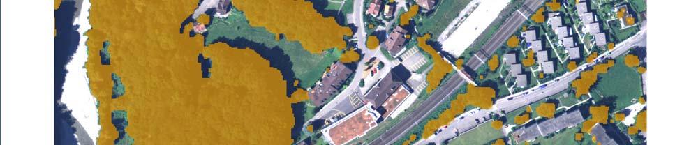
16 Further applications from production Example: swisstopo forest extraction DSM-DTM & Treshold Further applications from production Example: swisstopo forest extraction DSM-DTM & NDVI
 vs.")


17 Further applications from production Example: swisstopo forest extraction result (yellow) vs. VEC25 (white) Outline Geometry perfect Radiometry unknown? Part 1: Part 2: Part 3: Part 4: Introduction The manufacturer s perspective The user s perspective The standard s perspective
18 Standardization Standards are essential, also for later certification processes German standards DIN series Photogrammetric Products Part 4: Requirements of digital aerial cameras and digital aerial photographs Part 5: Classification of optical remote sensing data Part 6: Requirements of digital height models (under preparation) Part 7: Requirements on pan-sharpening (under preparation) International standardization ISO TS Geographic information Calibration and validation of remote sensing imagery sensors Part 1: Optical sensors Need for standards? Example: Sensor calibration in US Former: USGS calibration as mandatory quality proof USGS quality assurance plan ( Phowo 2007) Data procurement: Contract requirements & validation processes Date acquisition: Manufacturer / Sensor type certification & Data producer certification now modified to Independent Sensor Evaluation private companies offering calibration service: service covers in-situ camera calibration for analog and digital mapping cameras and independent accuracy validation of map products produced by airborne cameras. (press release Navmatica, May 2011)

19 Need for standards? Example: Sensor calibration in US Press release May 9, Summary Illustration of general status in digital airborne imaging with special emphasis on geometry and radiometry Geometry was first radiometry strongly evolving, but not yet highlighted by system providers? Still some deficiencies / lacks of information (user s side / manufacturers side) which ask for further improvement, i.e. full understanding of camera radiometry but also on geometry Geometry perfect Radiometry unknown? Yes? / No? / Perhaps?
Digital airborne cameras Status & future
 Institut für Photogrammetrie ifp Digital airborne cameras Status & future Michael Cramer Institute for Photogrammetry, Univ. of Stuttgart Geschwister-Scholl-Str.24, D-70174 Stuttgart Tel: + 49 711 121
EuroSDR project. Digital Camera Calibration. Michael Cramer. Presentation of project proposal
 Institut für Photogrammetrie EuroSDR project Digital Camera Calibration Michael Cramer michael.cramer@.uni-stuttgart.de Presentation of project proposal 103 rd EuroSDR Science and Steering Committee Meetings
Leica ADS80 - Digital Airborne Imaging Solution NAIP, Salt Lake City 4 December 2008
 Luzern, Switzerland, acquired at 5 cm GSD, 2008. Leica ADS80 - Digital Airborne Imaging Solution NAIP, Salt Lake City 4 December 2008 Shawn Slade, Doug Flint and Ruedi Wagner Leica Geosystems AG, Airborne
UltraCam and UltraMap Towards All in One Solution by Photogrammetry
 Photogrammetric Week '11 Dieter Fritsch (Ed.) Wichmann/VDE Verlag, Belin & Offenbach, 2011 Wiechert, Gruber 33 UltraCam and UltraMap Towards All in One Solution by Photogrammetry ALEXANDER WIECHERT, MICHAEL
DEVELOPMENT OF NDVI WMS GEOSERVICE FROM REFLECTANCE DMC IMAGERY AT ICC
 DEVELOPMENT OF NDVI WMS GEOSERVICE FROM REFLECTANCE DMC IMAGERY AT ICC L. Martínez a *, F. Pérez a, R. Arbiol b, A. Magariños c a Suporting Centre for the Catalan Earth Observation Program. Direction Area.
HIGH RESOLUTION COLOR IMAGERY FOR ORTHOMAPS AND REMOTE SENSING. Author: Peter Fricker Director Product Management Image Sensors
 HIGH RESOLUTION COLOR IMAGERY FOR ORTHOMAPS AND REMOTE SENSING Author: Peter Fricker Director Product Management Image Sensors Co-Author: Tauno Saks Product Manager Airborne Data Acquisition Leica Geosystems
A European Network on Digital Camera Calibration
 A European Network on Digital Camera Calibration By Dr. Michael Cramer, Institute for Photogrammetry (ifp), University of Stuttgart, Germany Edited By, Dr. Mohamed Mostafa, Applanix Corporation to be published
STATUS REPORT OF THE EUROSDR PROJECT RADIOMETRIC ASPECTS OF DIGITAL PHOTOGRAMMETRIC AIRBORNE IMAGES
 STATUS REPORT OF THE EUROSDR PROJECT RADIOMETRIC ASPECTS OF DIGITAL PHOTOGRAMMETRIC AIRBORNE IMAGES E. Honkavaaraa a*, R. Arbiol b, L. Markelin a, L. Martinez b, M. Cramer c, I. Korpela d, S. Bovet e,
CALIBRATING DIGITAL PHOTOGRAMMETRIC AIRBORNE IMAGING SYSTEMS IN A TEST FIELD
 CALIBRATING DIGITAL PHOTOGRAMMETRIC AIRBORNE IMAGING SYSTEMS IN A TEST FIELD Eija Honkavaara, Lauri Markelin, Eero Ahokas, Risto Kuittinen, Jouni Peltoniemi Finnish Geodetic Institute, Geodeetinrinne 2,
Camera Calibration Certificate No: DMC II
 Calibration DMC II 230 015 Camera Calibration Certificate No: DMC II 230 015 For Air Photographics, Inc. 2115 Kelly Island Road MARTINSBURG WV 25405 USA Calib_DMCII230-015_2014.docx Document Version 3.0
Vexcel Imaging GmbH Innovating in Photogrammetry: UltraCamXp, UltraCamLp and UltraMap
 Photogrammetric Week '09 Dieter Fritsch (Ed.) Wichmann Verlag, Heidelberg, 2009 Wiechert, Gruber 27 Vexcel Imaging GmbH Innovating in Photogrammetry: UltraCamXp, UltraCamLp and UltraMap ALEXANDER WIECHERT,
Calibration and validation of digital airborne cameras
 Institut für Photogrammetrie ifp Calibration and validation of digital airborne cameras The EuroSDR network on Digital Camera Calibration Michael Cramer michael.cramer@ifp.uni-stuttgart.de ISPRS Commission
Camera Calibration Certificate No: DMC II
 Calibration DMC II 140-036 Camera Calibration Certificate No: DMC II 140-036 For Midwest Aerial Photography 7535 West Broad St, Galloway, OH 43119 USA Calib_DMCII140-036.docx Document Version 3.0 page
UltraCam Eagle Prime Aerial Sensor Calibration and Validation
 UltraCam Eagle Prime Aerial Sensor Calibration and Validation Michael Gruber, Marc Muick Vexcel Imaging GmbH Anzengrubergasse 8/4, 8010 Graz / Austria {michael.gruber, marc.muick}@vexcel-imaging.com Key
Camera Calibration Certificate No: DMC II
 Calibration DMC II 140-005 Camera Calibration Certificate No: DMC II 140-005 For Midwest Aerial Photography 7535 West Broad St, Galloway, OH 43119 USA Calib_DMCII140-005.docx Document Version 3.0 page
Camera Calibration Certificate No: DMC II
 Calibration DMC II 230 027 Camera Calibration Certificate No: DMC II 230 027 For Peregrine Aerial Surveys, Inc. 103-20200 56 th Ave Langley, BC V3A 8S1 Canada Calib_DMCII230-027.docx Document Version 3.0
Camera Calibration Certificate No: DMC II Aero Photo Europe Investigation
 Calibration DMC II 250 030 Camera Calibration Certificate No: DMC II 250 030 For Aero Photo Europe Investigation Aerodrome de Moulins Montbeugny Yzeure Cedex 03401 France Calib_DMCII250-030.docx Document
Camera Calibration Certificate No: DMC IIe
 Calibration DMC IIe 230 23522 Camera Calibration Certificate No: DMC IIe 230 23522 For Richard Crouse & Associates 467 Aviation Way Frederick, MD 21701 USA Calib_DMCIIe230-23522.docx Document Version 3.0
Camera Calibration Certificate No: DMC II
 Calibration DMC II 230 020 Camera Calibration Certificate No: DMC II 230 020 For MGGP Aero Sp. z o.o. ul. Słowackiego 33-37 33-100 Tarnów Poland Calib_DMCII230-020.docx Document Version 3.0 page 1 of 40
Camera Calibration Certificate No: DMC III 27542
 Calibration DMC III Camera Calibration Certificate No: DMC III 27542 For Peregrine Aerial Surveys, Inc. #201 1255 Townline Road Abbotsford, B.C. V2T 6E1 Canada Calib_DMCIII_27542.docx Document Version
PROPERTY OF THE LARGE FORMAT DIGITAL AERIAL CAMERA DMC II
 PROPERTY OF THE LARGE FORMAT DIGITAL AERIAL CAMERA II K. Jacobsen a, K. Neumann b a Institute of Photogrammetry and GeoInformation, Leibniz University Hannover, Germany jacobsen@ipi.uni-hannover.de b Z/I
TELLS THE NUMBER OF PIXELS THE TRUTH? EFFECTIVE RESOLUTION OF LARGE SIZE DIGITAL FRAME CAMERAS
 TELLS THE NUMBER OF PIXELS THE TRUTH? EFFECTIVE RESOLUTION OF LARGE SIZE DIGITAL FRAME CAMERAS Karsten Jacobsen Leibniz University Hannover Nienburger Str. 1 D-30167 Hannover, Germany jacobsen@ipi.uni-hannover.de
CALIBRATING THE NEW ULTRACAM OSPREY OBLIQUE AERIAL SENSOR Michael Gruber, Wolfgang Walcher
 CALIBRATING THE NEW ULTRACAM OSPREY OBLIQUE AERIAL SENSOR Michael Gruber, Wolfgang Walcher Microsoft UltraCam Business Unit Anzengrubergasse 8/4, 8010 Graz / Austria {michgrub, wwalcher}@microsoft.com
ifp Universität Stuttgart EuroSDR network on Digital Camera Calibration Report Phase I (Status Oct 26, 2004)
") Universität Stuttgart EuroSDR network on Digital Camera Calibration Report Phase I (Status Oct 26, 2004) Michael Cramer Institute for Photogrammetry (ifp) University of Stuttgart Geschwister-Scholl-Str.
Universität Stuttgart EuroSDR network on Digital Camera Calibration Report Phase I (Status Oct 26, 2004) Michael Cramer Institute for Photogrammetry (ifp) University of Stuttgart Geschwister-Scholl-Str.
Airborne or Spaceborne Images for Topographic Mapping?
 Advances in Geosciences Konstantinos Perakis, Editor EARSeL, 2012 Airborne or Spaceborne Images for Topographic Mapping? Karsten Jacobsen Leibniz University Hannover, Institute of Photogrammetry and Geoinformation,
NEWS FROM THE ULTRACAM CAMERA LINE-UP INTRODUCTION
 NEWS FROM THE ULTRACAM CAMERA LINE-UP Alexander Wiechert, Michael Gruber Vexcel Imaging Austria / Microsoft Photogrammetry Anzengrubergasse 8/4, 8010 Graz / Austria {alwieche, michgrub}@microsoft.com ABSTRACT
Chapters 1-3. Chapter 1: Introduction and applications of photogrammetry Chapter 2: Electro-magnetic radiation. Chapter 3: Basic optics
 Chapters 1-3 Chapter 1: Introduction and applications of photogrammetry Chapter 2: Electro-magnetic radiation Radiation sources Classification of remote sensing systems (passive & active) Electromagnetic
EuroSDR-Project Commission 1 Radiometric aspects of digital photogrammetric. Final Report
 EuroSDR-Project Commission 1 Radiometric aspects of digital photogrammetric images Final Report Report by Eija Honkavaara and Lauri Markelin Remote Sensing and Photogrammetry Finnish Geodetic Institute,
USE OF DIGITAL AERIAL IMAGES TO DETECT DAMAGES DUE TO EARTHQUAKES
 USE OF DIGITAL AERIAL IMAGES TO DETECT DAMAGES DUE TO EARTHQUAKES Fumio Yamazaki 1, Daisuke Suzuki 2 and Yoshihisa Maruyama 3 ABSTRACT : 1 Professor, Department of Urban Environment Systems, Chiba University,
The EuroSDR network on Digital Camera Calibration and Validation
 Institut für Photogrammetrie The EuroSDR network on Digital Camera Calibration and Validation Michael Cramer michael.cramer@.uni-stuttgart.de 109th EuroSDR Meetings Lisboa, October 25-27, 06 Phase II Active
New remote sensing sensors and imaging products for the monitoring of urban dynamics
 Geoinformation for European-wide Integration, Benes (ed.) 2003 Millpress, Rotterdam, ISBN 90-77017-71-2 New remote sensing sensors and imaging products for the monitoring of urban dynamics Matthias Möller
Radiometric Calibration and Characterization of Large-format Digital Photogrammetric Sensors in a Test Field
 Radiometric Calibration and Characterization of Large-format Digital Photogrammetric Sensors in a Test Field Lauri Markelin, Eija Honkavaara, Jouni Peltoniemi, Eero Ahokas, Risto Kuittinen, Juha Hyyppä,
DEM Generation Using a Digital Large Format Frame Camera
 DEM Generation Using a Digital Large Format Frame Camera Joachim Höhle Abstract Progress in automated photogrammetric DEM generation is presented. Starting from the procedures and the performance parameters
Digital Photogrammetry. Presented by: Dr. Hamid Ebadi
 Digital Photogrammetry Presented by: Dr. Hamid Ebadi Background First Generation Analog Photogrammetry Analytical Photogrammetry Digital Photogrammetry Photogrammetric Generations 2000 digital photogrammetry
Leica - 3 rd Generation Airborne Digital Sensors Features / Benefits for Remote Sensing & Environmental Applications
 Leica - 3 rd Generation Airborne Digital Sensors Features / Benefits for Remote Sensing & Environmental Applications Arthur Rohrbach, Sensor Sales Dir Europe, Middle-East and Africa (EMEA) Luzern, Switzerland,
Calibration Report. Short Version. UltraCam Eagle, S/N UC-E f210. Vexcel Imaging GmbH, A-8010 Graz, Austria
 Calibration Report Short Version Camera: Manufacturer: Date of Calibration: Date of Report: Revision of Camera: Version of Report: UltraCam Eagle, S/N UC-E-1-00518105-f210 Vexcel Imaging GmbH, A-8010 Graz,
HIGH RESOLUTION IMAGERY FOR MAPPING AND LANDSCAPE MONITORING
 HIGH RESOLUTION IMAGERY FOR MAPPING AND LANDSCAPE MONITORING Karsten Jacobsen Leibniz University Hannover, Institute of Photogrammetry and Geoinformation Nienburger Str. 1, 30165 Hannover, Germany, jacobsen@ipi.uni-hannover.de
UltraCam and UltraMap An Update
 Photogrammetric Week '13 Dieter Fritsch (Ed.) Wichmann/VDE Verlag, Belin & Offenbach, 2013 Wiechert 37 UltraCam and UltraMap An Update ALEXANDER WIECHERT, Graz ABSTRACT When UltraCam D was presented first
COMPARISON OF INFORMATION CONTENTS OF HIGH RESOLUTION SPACE IMAGES
 COMPARISON OF INFORMATION CONTENTS OF HIGH RESOLUTION SPACE IMAGES H. Topan*, G. Büyüksalih*, K. Jacobsen ** * Karaelmas University Zonguldak, Turkey ** University of Hannover, Germany htopan@karaelmas.edu.tr,
Aerial Triangulation Radiometry Essentials Dense Matching Ortho Generation
 Radiometry Aerial Triangulation Essentials Dense Matching Ortho Generation Highly advanced photogrammetric workflow system for UltraCam images. Microsoft UltraMap is a state-of-the-art, end-to-end, complete
RECENT DEVELOPMENTS OF DIGITAL CAMERAS AND SPACE IMAGERY. Karsten JACOBSEN
 RECENT DEVELOPMENTS OF DIGITAL CAMERAS AND SPACE IMAGERY Abstract Karsten JACOBSEN Leibniz University Hannover, Institute of Photogrammetry and Geoinformation, Nienburger Str. 1, D-30167 Hannover, Germany
An Introduction to Geomatics. Prepared by: Dr. Maher A. El-Hallaq خاص بطلبة مساق مقدمة في علم. Associate Professor of Surveying IUG
 An Introduction to Geomatics خاص بطلبة مساق مقدمة في علم الجيوماتكس Prepared by: Dr. Maher A. El-Hallaq Associate Professor of Surveying IUG 1 Airborne Imagery Dr. Maher A. El-Hallaq Associate Professor
PHOTOGRAMMETRIC RESECTION DIFFERENCES BASED ON LABORATORY vs. OPERATIONAL CALIBRATIONS
 PHOTOGRAMMETRIC RESECTION DIFFERENCES BASED ON LABORATORY vs. OPERATIONAL CALIBRATIONS Dean C. MERCHANT Topo Photo Inc. Columbus, Ohio USA merchant.2@osu.edu KEY WORDS: Photogrammetry, Calibration, GPS,
Update on UltraCam and UltraMap technology
 Update on UltraCam and UltraMap technology Alexander Wiechert, Michael Gruber Anzengrubergasse 8/4, 8010 Graz, Austria {alexander.wiechert, michael.gruber}@vexcel-imaging.com Stuttgart, September 2017
remote sensing? What are the remote sensing principles behind these Definition
 Introduction to remote sensing: Content (1/2) Definition: photogrammetry and remote sensing (PRS) Radiation sources: solar radiation (passive optical RS) earth emission (passive microwave or thermal infrared
AT-SATELLITE REFLECTANCE: A FIRST ORDER NORMALIZATION OF LANDSAT 7 ETM+ IMAGES
 AT-SATELLITE REFLECTANCE: A FIRST ORDER NORMALIZATION OF LANDSAT 7 ETM+ IMAGES Chengquan Huang*, Limin Yang, Collin Homer, Bruce Wylie, James Vogelman and Thomas DeFelice Raytheon ITSS, EROS Data Center
Digital Aerial Photography UNBC March 22, Presented by: Dick Mynen TDB Consultants Inc.
 Digital Aerial Photography UNBC March 22, 2011 Presented by: Dick Mynen TDB Consultants Inc. Airborne Large Scale Digital Photography Who is using the technology in today s environment Options available
Introduction to Remote Sensing
 Introduction to Remote Sensing Spatial, spectral, temporal resolutions Image display alternatives Vegetation Indices Image classifications Image change detections Accuracy assessment Satellites & Air-Photos
Processing of stereo scanner: from stereo plotter to pixel factory
 Photogrammetric Week '03 Dieter Fritsch (Ed.) Wichmann Verlag, Heidelberg, 2003 Bignone 141 Processing of stereo scanner: from stereo plotter to pixel factory FRANK BIGNONE, ISTAR, France ABSTRACT With
POTENTIAL OF LARGE FORMAT DIGITAL AERIAL CAMERAS. Dr. Karsten Jacobsen Leibniz University Hannover, Germany
 POTENTIAL OF LARGE FORMAT DIGITAL AERIAL CAMERAS Dr. Karsten Jacobsen Leibniz University Hannover, Germany jacobsen@ipi.uni-hannover.de Introduction: Digital aerial cameras are replacing traditional analogue
University of Texas at San Antonio EES 5053 Term Project CORRELATION BETWEEN NDVI AND SURFACE TEMPERATURES USING LANDSAT ETM + IMAGERY NEWFEL MAZARI
 University of Texas at San Antonio EES 5053 Term Project CORRELATION BETWEEN NDVI AND SURFACE TEMPERATURES USING LANDSAT ETM + IMAGERY NEWFEL MAZARI Introduction and Objectives The present study is a correlation
Calibration Report. Short version. UltraCam Xp, S/N UC-SXp Vexcel Imaging GmbH, A-8010 Graz, Austria
 Calibration Report Short version Camera: Manufacturer: UltraCam Xp, S/N UC-SXp-1-61212452 Vexcel Imaging GmbH, A-8010 Graz, Austria Date of Calibration: Mar-05-2009 Date of Report: Mar-13-2009 Camera Revision:
Calibration Report. UC-SXp Version of Report:
 Calibration Report Camera: Serial: UltraCam Xp UC-SXp-1-40719017 Calibration Date: Date of Report: Camera Revision: Version of Report: Feb-28-2018 Mar-05-2018 Rev13.00 V01 www.vexcel-imaging.com Copyright
Calibration Report. Short Version. UltraCam L, S/N UC-L Vexcel Imaging GmbH, A-8010 Graz, Austria
 Calibration Report Short Version Camera: Manufacturer: UltraCam L, S/N UC-L-1-00612089 Vexcel Imaging GmbH, A-8010 Graz, Austria Date of Calibration: Mar-23-2010 Date of Report: May-17-2010 Camera Revision:
EVALUATION OF PLEIADES-1A TRIPLET ON TRENTO TESTFIELD
 EVALUATION OF PLEIADES-1A TRIPLET ON TRENTO TESTFIELD D. Poli a, F. Remondino b, E. Angiuli c, G. Agugiaro b a Terra Messflug GmbH, Austria b 3D Optical Metrology Unit, Fondazione Bruno Kessler, Trento,
Application of GIS to Fast Track Planning and Monitoring of Development Agenda
 Application of GIS to Fast Track Planning and Monitoring of Development Agenda Radiometric, Atmospheric & Geometric Preprocessing of Optical Remote Sensing 13 17 June 2018 Outline 1. Why pre-process remotely
ENHANCEMENT OF THE RADIOMETRIC IMAGE QUALITY OF PHOTOGRAMMETRIC SCANNERS.
 ENHANCEMENT OF THE RADIOMETRIC IMAGE QUALITY OF PHOTOGRAMMETRIC SCANNERS Klaus NEUMANN *, Emmanuel BALTSAVIAS ** * Z/I Imaging GmbH, Oberkochen, Germany neumann@ziimaging.de ** Institute of Geodesy and
Calibration Report. UltraCam Eagle, S/N UC-Eagle f80. Vexcel Imaging GmbH, A-8010 Graz, Austria
 Calibration Report Camera: Manufacturer: UltraCam Eagle, S/N UC-Eagle-1-60411397-f80 Vexcel Imaging GmbH, A-8010 Graz, Austria Date of Calibration: Jul-23-2013 Date of Report: Aug-06-2013 Camera Revision:
Calibration Report. Short Version. Vexcel Imaging GmbH, A-8010 Graz, Austria
 Calibration Report Short Version Camera: Manufacturer: UltraCam D, S/N UCD-SU-2-0039 Vexcel Imaging GmbH, A-8010 Graz, Austria Date of Calibration: Mar-14-2011 Date of Report: Mar-17-2011 Camera Revision:
ABOUT FRAME VERSUS PUSH-BROOM AERIAL CAMERAS
 ABOUT FRAME VERSUS PUSH-BROOM AERIAL CAMERAS Franz Leberl and Michael Gruber Microsoft Photogrammetry, 8010 Graz ABSTRACT When presenting digital large format aerial cameras to the interested community
LPIS Orthoimagery An assessment of the Bing imagery for LPIS purpose
 LPIS Orthoimagery An assessment of the Bing imagery for LPIS purpose Slavko Lemajić Wim Devos, Pavel Milenov GeoCAP Action - MARS Unit - JRC Ispra Tallinn, 24 th November 2011 Outline JRC`s Ortho specifications
Technical Evaluation of Khartoum State Mapping Project
 Technical Evaluation of Khartoum State Mapping Project Nagi Zomrawi 1 and Mohammed Fator 2 1 School of Surveying Engineering, Collage of Engineering, Sudan University of Science and Technology, Khartoum,
ULTRACAMX AND A NEW WAY OF PHOTOGRAMMETRIC PROCESSING
 ULTRACAMX AND A NEW WAY OF PHOTOGRAMMETRIC PROCESSING Michael Gruber, Bernhard Reitinger Microsoft Photogrammetry Anzengrubergasse 8, A-8010 Graz, Austria {michgrub, bernreit}@microsoft.com ABSTRACT This
Calibration Certificate
 Calibration Certificate Digital Mapping Camera (DMC) DMC Serial Number: DMC01-0053 CBU Serial Number: 0100053 For MPPG AERO Sp. z. o. o., ul. Kaczkowskiego 6 33-100 Tarnow Poland System Overview Flight
PRELIMINARY RESULTS FROM THE PORTABLE IMAGERY QUALITY ASSESSMENT TEST FIELD (PIQuAT) OF UAV IMAGERY FOR IMAGERY RECONNAISSANCE PURPOSES
 OF UAV IMAGERY FOR IMAGERY RECONNAISSANCE PURPOSES") PRELIMINARY RESULTS FROM THE PORTABLE IMAGERY QUALITY ASSESSMENT TEST FIELD (PIQuAT) OF UAV IMAGERY FOR IMAGERY RECONNAISSANCE PURPOSES R. Dabrowski a, A. Orych a, A. Jenerowicz a, P. Walczykowski a, a
PRELIMINARY RESULTS FROM THE PORTABLE IMAGERY QUALITY ASSESSMENT TEST FIELD (PIQuAT) OF UAV IMAGERY FOR IMAGERY RECONNAISSANCE PURPOSES R. Dabrowski a, A. Orych a, A. Jenerowicz a, P. Walczykowski a, a
INCREASING GEOMETRIC ACCURACY OF DMC S VIRTUAL IMAGES
 INCREASING GEOMETRIC ACCURACY OF DMC S VIRTUAL IMAGES M. Madani, I. Shkolnikov Intergraph Corporation, Alabama, USA (mostafa.madani@intergraph.com) Commission I, WG I/1 KEY WORDS: Digital Aerial Cameras,
Baldwin and Mobile Counties, AL Orthoimagery Project Report. Submitted: March 23, 2016
 2015 Orthoimagery Project Report Submitted: Prepared by: Quantum Spatial, Inc 523 Wellington Way, Suite 375 Lexington, KY 40503 859-277-8700 Page i of iii Contents Project Report 1. Summary / Scope...
Govt. Engineering College Jhalawar Model Question Paper Subject- Remote Sensing & GIS
 Govt. Engineering College Jhalawar Model Question Paper Subject- Remote Sensing & GIS Time: Max. Marks: Q1. What is remote Sensing? Explain the basic components of a Remote Sensing system. Q2. What is
ANALYZING DMC PERFORMANCE IN A PRODUCTION ENVIRONMENT
 ANALYZING DMC PERFORMANCE IN A PRODUCTION ENVIRONMENT J. Talaya, W. Kornus, R. Alamús, E. Soler, M. Pla, A. Ruiz Institut Cartogràfic de Catalunya, 08038 Barcelona, Spain (julia.talaya, wolfgang.kornus,
Use of digital aerial camera images to detect damage to an expressway following an earthquake
 Use of digital aerial camera images to detect damage to an expressway following an earthquake Yoshihisa Maruyama & Fumio Yamazaki Department of Urban Environment Systems, Chiba University, Chiba, Japan.
Camera Requirements For Precision Agriculture
 Camera Requirements For Precision Agriculture Radiometric analysis such as NDVI requires careful acquisition and handling of the imagery to provide reliable values. In this guide, we explain how Pix4Dmapper
RADIOMETRIC CALIBRATION
 1 RADIOMETRIC CALIBRATION Lecture 10 Digital Image Data 2 Digital data are matrices of digital numbers (DNs) There is one layer (or matrix) for each satellite band Each DN corresponds to one pixel 3 Digital
REMOTE SENSING WITH DRONES. YNCenter Video Conference Chang Cao
 REMOTE SENSING WITH DRONES YNCenter Video Conference Chang Cao 08-28-2015 28 August 2015 2 Drone remote sensing It was first utilized in military context and has been given great attention in civil use
Geometric Property of Large Format Digital Camera DMC II 140
 PFG 2011 / 2, 071 079, March 2011 Geometric Property of Large Format Digital Camera DMC II 140 KARSTEN JACOBSEN, Hannover Keywords: Digital camera, geometry, large format CCD, systematic image errors Summary:
At-Satellite Reflectance: A First Order Normalization Of Landsat 7 ETM+ Images
 University of Nebraska - Lincoln DigitalCommons@University of Nebraska - Lincoln Publications of the US Geological Survey US Geological Survey 21 At-Satellite Reflectance: A First Order Normalization Of
CHARACTERISTICS OF REMOTELY SENSED IMAGERY. Spatial Resolution
 CHARACTERISTICS OF REMOTELY SENSED IMAGERY Spatial Resolution There are a number of ways in which images can differ. One set of important differences relate to the various resolutions that images express.
Automated GIS data collection and update
 Walter 267 Automated GIS data collection and update VOLKER WALTER, S tuttgart ABSTRACT This paper examines data from different sensors regarding their potential for an automatic change detection approach.
Camera Requirements For Precision Agriculture
 Camera Requirements For Precision Agriculture Radiometric analysis such as NDVI requires careful acquisition and handling of the imagery to provide reliable values. In this guide, we explain how Pix4Dmapper
EXAMPLES OF TOPOGRAPHIC MAPS PRODUCED FROM SPACE AND ACHIEVED ACCURACY CARAVAN Workshop on Mapping from Space, Phnom Penh, June 2000
 EXAMPLES OF TOPOGRAPHIC MAPS PRODUCED FROM SPACE AND ACHIEVED ACCURACY CARAVAN Workshop on Mapping from Space, Phnom Penh, June 2000 Jacobsen, Karsten University of Hannover Email: karsten@ipi.uni-hannover.de
A (very) brief introduction to Remote Sensing: From satellites to maps!
 brief introduction to Remote Sensing: From satellites to maps!") Spatial Data Analysis and Modeling for Agricultural Development, with R - Workshop A (very) brief introduction to Remote Sensing: From satellites to maps! Earthlights DMSP 1994-1995 https://wikimedia.org/
Spatial Data Analysis and Modeling for Agricultural Development, with R - Workshop A (very) brief introduction to Remote Sensing: From satellites to maps! Earthlights DMSP 1994-1995 https://wikimedia.org/
NORMALIZING ASTER DATA USING MODIS PRODUCTS FOR LAND COVER CLASSIFICATION
 NORMALIZING ASTER DATA USING MODIS PRODUCTS FOR LAND COVER CLASSIFICATION F. Gao a, b, *, J. G. Masek a a Biospheric Sciences Branch, NASA Goddard Space Flight Center, Greenbelt, MD 20771, USA b Earth
LECTURE NOTES 2016 CONTENTS. Sensors and Platforms for Acquisition of Aerial and Satellite Image Data
 LECTURE NOTES 2016 Prof. John TRINDER School of Civil and Environmental Engineering Telephone: (02) 9 385 5020 Fax: (02) 9 313 7493 j.trinder@unsw.edu.au CONTENTS Chapter 1 Chapter 2 Sensors and Platforms
QUALITY COMPARISON OF DIGITAL AND FILM-BASED IMAGES FOR PHOTOGRAMMETRIC PURPOSES Roland Perko 1 Andreas Klaus 2 Michael Gruber 3
 QUALITY COMPARISON OF DIGITAL AND FILM-BASED IMAGES FOR PHOTOGRAMMETRIC PURPOSES Roland Perko 1 Andreas Klaus 2 Michael Gruber 3 1 Institute for Computer Graphics and Vision, Graz University of Technology,
Introduction to Remote Sensing Fundamentals of Satellite Remote Sensing. Mads Olander Rasmussen
 Introduction to Remote Sensing Fundamentals of Satellite Remote Sensing Mads Olander Rasmussen (mora@dhi-gras.com) 01. Introduction to Remote Sensing DHI What is remote sensing? the art, science, and technology
Remote Sensing for Rangeland Applications
 Remote Sensing for Rangeland Applications Jay Angerer Ecological Training June 16, 2012 Remote Sensing The term "remote sensing," first used in the United States in the 1950s by Ms. Evelyn Pruitt of the
D. Hunter, J. Smart Kern & Co.., Ltd 5000 Aarau switzerland Commission II, ISPRS Kyoto, July 1988
 IMAGE ORIENTATION ON THE KERN DSR D. Hunter, J. Smart Kern & Co.., Ltd 5000 Aarau switzerland Commission II, ISPRS Kyoto, July 1988 Abstract A description of the possible image orientation capabilities
Topographic mapping from space K. Jacobsen*, G. Büyüksalih**
 Topographic mapping from space K. Jacobsen*, G. Büyüksalih** * Institute of Photogrammetry and Geoinformation, Leibniz University Hannover ** BIMTAS, Altunizade-Istanbul, Turkey KEYWORDS: WorldView-1,
VisionMap Sensors and Processing Roadmap
 Vilan, Gozes 51 VisionMap Sensors and Processing Roadmap YARON VILAN, ADI GOZES, Tel-Aviv ABSTRACT The A3 is a family of digital aerial mapping cameras and photogrammetric processing systems, which is
TEMPORAL ANALYSIS OF MULTI EPOCH LANDSAT GEOCOVER IMAGES IN ZONGULDAK TESTFIELD
 TEMPORAL ANALYSIS OF MULTI EPOCH LANDSAT GEOCOVER IMAGES IN ZONGULDAK TESTFIELD Şahin, H. a*, Oruç, M. a, Büyüksalih, G. a a Zonguldak Karaelmas University, Zonguldak, Turkey - (sahin@karaelmas.edu.tr,
MEDIUM FORMAT CAMERA EVALUATION BASED ON THE LATEST PHASE ONE TECHNOLOGY
 MEDIUM FORMAT CAMERA EVALUATION BASED ON THE LATEST PHASE ONE TECHNOLOGY T.Tölg a, G. Kemper b, D. Kalinski c a Phase One / Germany tto@phaseone.com b GGS GmbH, Speyer / Germany kemper@ggs-speyer.de c
VisionMap A3 Edge A Single Camera for Multiple Solutions
 Photogrammetric Week '15 Dieter Fritsch (Ed.) Wichmann/VDE Verlag, Belin & Offenbach, 2015 Raizman, Gozes 57 VisionMap A3 Edge A Single Camera for Multiple Solutions Yuri Raizman, Adi Gozes, Tel-Aviv ABSTRACT
Metric Accuracy Testing with Mobile Phone Cameras
 Metric Accuracy Testing with Mobile Phone Cameras Armin Gruen,, Devrim Akca Chair of Photogrammetry and Remote Sensing ETH Zurich Switzerland www.photogrammetry.ethz.ch Devrim Akca, the 21. ISPRS Congress,
Lecture 1 Introduction to Remote Sensing
 Lecture 1 Introduction to Remote Sensing Dr Ian Leiper School of Environmental and Life Sciences Bldg Purple 12.2.27 1 2 Lecture Outline Introductions Unit admin Learning outcomes Unit outline Practicals
High Resolution Sensor Test Comparison with SPOT, KFA1000, KVR1000, IRS-1C and DPA in Lower Saxony
 High Resolution Sensor Test Comparison with SPOT, KFA1000, KVR1000, IRS-1C and DPA in Lower Saxony K. Jacobsen, G. Konecny, H. Wegmann Abstract The Institute for Photogrammetry and Engineering Surveys
Calibration Report. Short version. UltraCam X, S/N UCX-SX Microsoft Photogrammetry, A-8010 Graz, Austria. ( 1 of 13 )
") Calibration Report Short version Camera: Manufacturer: UltraCam X, S/N UCX-SX-1-30518177 Microsoft Photogrammetry, A-8010 Graz, Austria Date of Calibration: May-24-2007 Date of Report: Jun-21-2007 Camera
Calibration Report Short version Camera: Manufacturer: UltraCam X, S/N UCX-SX-1-30518177 Microsoft Photogrammetry, A-8010 Graz, Austria Date of Calibration: May-24-2007 Date of Report: Jun-21-2007 Camera
An Introduction to Remote Sensing & GIS. Introduction
 An Introduction to Remote Sensing & GIS Introduction Remote sensing is the measurement of object properties on Earth s surface using data acquired from aircraft and satellites. It attempts to measure something
EVALUATION OF RESOLVING POWER AND MTF OF DMC
 EVALUATION OF RESOLVING POWER AND MTF OF DMC E. Honkavaara 1, J. Jaakkola 1, L. Markelin 1, S. Becker 2 1 Finnish Geodetic Institute, Masala, Finland (eija.honkavaara, juha.jaakkola, lauri.markelin)@gi.i
Lecture 7. Leica ADS 80 Camera System and Imagery. Ontario ADS 80 FRI Imagery. NRMT 2270, Photogrammetry/Remote Sensing
 NRMT 2270, Photogrammetry/Remote Sensing Lecture 7 Leica ADS 80 Camera System and Imagery. Ontario ADS 80 FRI Imagery. Tomislav Sapic GIS Technologist Faculty of Natural Resources Management Lakehead University
** KEYSTONE AERIAL SURVEYS R. David Day, Wesley Weaver **
 AN ACCURACY ANALYSIS OF LARGE RESOLUTION IMAGES CAPTURED WITH THE NIKON D810 DIGITAL CAMERA SYSTEM Ricardo M. Passini * * ricardopassini2012@outlook.com ** KEYSTONE AERIAL SURVEYS R. David Day, Wesley