How to get base geospatial data for SDI from high resolution satellite images
|
|
|
- Timothy Lawrence
- 5 years ago
- Views:
Transcription

1 How to get base geospatial data for SDI from high resolution satellite images E. Baltsavias with contributions from Zhang Li, Henri Eisenbeiss, Maria Pateraki, Daniela Poli, Chunsun Zhang, Fabio Remondino, Clive Fraser Institute of Geodesy and Photogrammetry ETH-Hoenggerberg, CH-8093 Zurich, Switzerland Tel.: , Fax: Sponsored by Contents 1. Introduction (motivation, overview) 2. Image Preprocessing 3. Sensor Models 4. DSM Generation 5. Orthoimage Generation 6. Extraction of roads and buildings 7. Software package SAT-PP of ETHZ 8. An application example from cultural heritage 9. Conclusions and Outlook 1
 In an increasing number of countries Geodata necessary for development and informed decisions Geodata are part of SDI Among them base data the most important (framework data) Base data: maps, DSMs,")
2 Spatial Data Infrastructure Implemented at different levels (global, national, local etc.) In an increasing number of countries Geodata necessary for development and informed decisions Geodata are part of SDI Among them base data the most important (framework data) Base data: maps, DSMs, DTMs, orthoimages, land cover and land use, roads, buildings, names, boundaries etc. Spatial Data Infrastructure 2

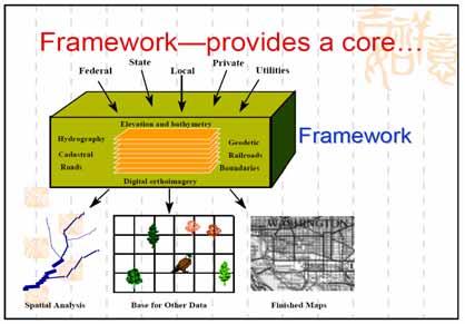
3 Framework Framework 3
4 Role of satellite imagery Imagery an increasingly important source for base data acquisition and update Satellite images generally cheaper than aerial images Repetitive coverage of large, remote or forbidden areas Many satellites, increasing number in future Aerial imagery often not readily available in developing countries (also military restrictions) High spatial resolution (HR) satellites Ground Sampling Distance (GSD) down to 0.61 m, 0.4 m in 2007, 0.25 in 2008? Almost all are stereo capable High geometric accuracy potential Increasing support by commercial software packages But, Not high availability. Hopes for improved availability with more such systems planned. High costs. Hopes for lower costs with increasing competition and noncommercial systems (like Japanese ALOS-PRISM, 2.5 m PAN GSD, to be launched soon) and small, low-cost HR satellites (like Topsat, UK) 4
5 How is a HR sensor defined here? Definition changes with time. 10 years ago, 10 m GSD was considered HR, not now Here HR, if panchromatic (PAN) GSD max. about 3 m Multispectral channels (MS) usually employed and have 2-4 times larger GSD Here only optical sensors, not microwave or laser scanners Pure military systems not treated here Most optical HR sensors use linear CCDs Many have military heritage, and are still used for dual purposes Some data for HR sensors kept secret. Useful source of info Mission or Satellite Sensor Country System type Launch date or 9/1999 duration Sensor type digital PAN GSD (m) 1 (across x along track) PAN Pixels of line CCD / Pixel spacing (μm) Flying height (km), Focal length (m) Ikonos-2 OSA 13,816 / , 10 BHRC60 10/2001 digital ,568 / , Specifications of current HR satellite missions (status July 2005) Quickbird-2 Orbview-3 OHRIS 6/2003 digital 1 8,000 / 12,000 6 x 5.4, (2 lines for unknown if HRG) / numbers here 6.5 for staggered or not 470, 2.77 SPOT 5 HRG, HRS 5/2002 digital digital 5 or (oversampled) HRG 10 x 5 HRS , HRG 0.58 HRS IRS-P5 (Cartosat-1) 2 PAN cameras USA USA USA France, India Belgium, Sweden Commercial Commercial Commercial Commercial Commercial 5/ ,288 / 7 618, 1.98 FormoSat-2 (formerly ROCSat-2) RSI Taiwan Commercial 5/2004 digital 2 12,000 / , EROS A1 PIC Israel Commercial 12/2000 digital film or 1.4 (oversampled) 7,043 (2 lines) / ca. 13 ca. 500, 3.4 Cosmos 1, many missions KVR 1000 panoramic camera (2 working alternatively) Russia Commercial Variable ( ), 1 Corona (KH-KH-7, 1 to KH-4), many many missions missions Stereo panoramic cameras USA Military, declassified film Variable, High Resolution Surveillance Camera USA Military, declassified film At nadir down to Variable,
6 Specifications of current HR satellite missions (status July 2005) Mission or Satellite No. of MS Channels / GSD (m) Stereo 2 Swath width 11 (km) or Image film dimensions (cm) Field Of Regard 3 (deg) TDI Ikonos-2 Along track Y triplette ability Body up to > 1 rotation angular rate 4 (deg/sec) 4 / 4 4 / / 4 (excl. Vegetation 0 instrument) 4 / 10 and 20 along-track, along-track, along-track, along-track, along-track across-track across-track across-track across-track 45, up to deg images shot Y Y Quickbird-2 Orbview ? N?? SPOT 5 60 HRG, 120 HRS 27 (HRG, only across track) N N N IRS-P5 FormoSat-2 EROS A1 (Cartosat-1) 30 N 4 / 8 along-track, along-track, across-track across-track N? , 10 for 18 x 72 oversampled (across) images 45 N Y 1.8 Cosmos, many missions 0 no stereo Corona (KH-1 to KH-4), many missions x (across) N KH-7, many missions very few color & CIR images few images in stereo 22.8 x variable (across) N Specifications of current HR satellite missions (status July 2005) Mission or Satellite Ikonos-2 FOV (deg) 0.93 or film area coverage No. of 11 quantization bits Scale 68,100 factor Stereo up to 100 overlap (%) B/H ratio variable Quickbird-2 Orbview-3 SPOT ,100 up to 100 variable , ,500 HRG, 312,000 1,422,500 HRS up to 100 up to 100 up to 100 variable 4.13 HRG 7.7 HRS 8 up to 1.1 HRG, 0.8 (40 deg.) HRS IRS-P5 FormoSat-2 EROS A1 (Cartosat-1) (31 deg.) ,000 up to 100 variable ,000 up to 100 variable Cosmos, many missions 40 x 160 km 14 x 189 (typical) (typical) alongtrack 190, , Corona (KH- 1 to KH-4), many missions Variable, ca. 250,000 typical up to 100? 0.60 (30 deg.)? KH-7, many missions Variable 1 Actual name is Kometa Space Mapping System, on-board of Cosmos satellites, which have been used for other purposes too. 2 Along-track is often used as synonymous to quasi-simultaneous (QS) stereo image acquisition (time difference in the order of 1 min), while across-track as synonymous to different orbit (DO) stereo image acquisition. Later definition is wrong. Agile satellites can acquire QS stereo images across-track, while with other satellites like SPOT-5 across-track means DO stereo. 3 The Field Of Regard is given here as +/- the numbers in the table. It is valid for all pointing directions, except for SPOT-5 where it refers only to across-track. Some satellites can acquire images with even smaller sensor elevation than the one mentioned in the table under certain restrictions (e.g. Ikonos images with 30 deg elevation have been acquired). 4 The angular rate generally increases, the longer the rotation time period is. 6
7 Important characteristics of HRS Very narrow across-track Field of View - down to 0.9 deg for Ikonos - small influence of height errors, accurate orthoimages when high sensor elevation, even with poor quality DTM/DSM Variable scanning modes reverse, forward (Ikonos, Quickbird) or Flight direction from N to S First line scanned is dotted Usual and preferred mode is reverse Forward (scan from S to N) Reverse (scan from N to S) Forward used to scan more images within a given time, by reducing time needed to rotate the satellite body, e.g. when acquiring multiple neighbouring strips, or triplettes within a strip. The satellite body rotates continuously with an almost constant angular velocity Flight direction from N to S Middle strip scanned in forward mode Important characteristics of HRS Often use of TDI (Time Delay and Integration) technology (Ikonos, Quickbird) - Aim: to increase pixel integration time in scanning direction for better image quality and signal to noise ratio, by summing up the signal of multiple lines - Used especially for fast moving objects (or platforms) and low light level conditions - Necessary, especially when the GSD is small (thus, used mainly for PAN only) - TDI is rectangular CCD chip with many lines (called also stages). Ikonos and Quickbird use max. 32 stages. How many are actually used is programmable from the ground station. Usually 13 with Ikonos. Use of more can lead to saturation. They can have 1 or 2 readout registers. The readout register must be at the TDI end in the scanning direction. Ikonos and Quickbird use older technology with 1 register. Thus, need 2 TDI to scan in both forward and reverse mode. A ground sample is imaged by multiple TDI lines, the signal is summed up and shifted to the readout register N Readout register needed to scan from N to S S 7

8 Important characteristics of HRS Rotation of satellite from S to N done also for other reasons a) to achieve a smaller GSD (the nominal one) in flight direction With Quickbird, GSD in flight direction would be larger than 0.61 m in PAN, for the given satellite speed and pixel integration time. Thus, the satellite rotates from S to N a bit to achieve m GSD. This happens in both Reverse and Forward mode! Satellite body rotation can introduce nonlinearities in the imaging geometry. b) to increase pixel integration time and achieve better image quality, when the sensor does not use TDI, e.g. EROS A1 This feature is inferior to TDI, can introduce nonlinearities in the imaging geometry and may cause pixel and edge smearing (unsharpness) In both cases, the imaged earth part (given often as line scan frequency for line CCDs), is shorter than the ground track of the satellite. A linescan frequency of e.g lines/s, means 1/1500 s (0.67 ms) integration time (IT). Note: linear CCDs can have an exposure time (effective IT) smaller than the nominal IT. We assume that satellite firms use the term IT in the sense of exposure time. Important characteristics of HRS Use of multiple CCDs - butted (Ikonos, Quickbird) to increase the across track FOV (swath width) - staggered (SPOT-5 HRG, Orbview-3) to decrease, usually by about the half, the GSD Multiple butted CCDs (example below Ikonos) 5 channels Each channel consists of 3 CCD parts forming a virtual line, the middle part is shifted From top to bottom: - MS linear CCD (4 channels/lines) - Reverse TDI PAN (32 lines/stages) - Forward TDI PAN (32 lines/stages) Quickbird has similar focal plane but double width and 6 CCD parts per virtual line, with a total of 18 linear CCD chips and 408 partial CCD lines! 8

9 Important characteristics of HRS Staggered CCDs (example here SPOT-5 HRG) - Used to decrease the GSD by avoiding too long focal length, small pixel spacing or low flying height - Used primarily only for PAN - Use of 2 identical CCD lines, shifted in line CCD direction, by 0.5 pixel - Distance of 2 lines in scanning direction, as small as possible, for SPOT 3.45 pixels - The data from 2 CCDs are interleaved and interpolated with various algorithms - Then, often a restoration (denoising) is performed - Thus, for SPOT-5 HRG the original GSD of 5 m, can be improved to m Important characteristics of HRS Multispectral CCDs - Often the pixel size given by the firms, e.g. 48 microns for Ikonos and Quickbird, is not correct. - Linear CCDs with so large pixel size not available in standard products - Usually the MS CCDs are identical to the PAN CCDs with very thin filters covering the pixels, thus for Ikonos and Quickbird they have 12 microns pixel size. - The larger effective pixel size (e.g. 48 microns) is achieved in scanning direction by increasing the integration time (e.g. for Ikonos by 4) and in the CCD line direction by averaging (binning) of pixels (e.g. 4 pixels) - This mode of generation leads to better image quality than producing images with real 48 microns pixel size. This may explain why geometric accuracy with MS images is only about 2 times worse than that of PAN, and not 4 times as might have been expected. 9
 +")

 Sharpen image especially in")
")

10 Image quality analysis - Ikonos PAN MSI Stereopair Nadir with (- Zug PAN MSI DRA A ( Geo Nisyros) + Melbourne Zug ( PAN Luzern) B) ( Melbourne) ) Radiometric Quality Preprocessing by Space Imaging (similar by other firms too): Modulation Transfer Function Correction (MTFC) Sharpen image especially in scan direction due to TDI imaging (typically 13 lines), which causes blurring Dynamic Range Adjustment (DRA) Stretch grey values to better occupy grey value range Additional artifacts are due to compression from 11 to 2.6 bit (esp. in homogeneous areas) 10
")


 Greek")
11 Radiometric Quality Important aspects for Feature Extraction and Interpretation Pan-Sharpened 1m Ikonos (7 0 tilt, summer end) Stereo 1m Ikonos (29 0 tilt, winter) View angle Sun angle & Shadowing Season Atmospheric conditions Stereo or mono Colour or B&W Image preprocessing Building characteristics & size factors over which there is no or limited user control Radiometric Quality Image quality / interpretability can vary dramatically Images taken the same day of April from the same orbit Luzern (CH) Greek village (Nisyros) 11
12 Radiometric Quality 11bit histogram Nadir PAN (Melbourne) - without DRA bit histogram Nadir PAN (Luzern) - with DRA D R A stretches the grey values (GVs) to cover more uniformly the 11 bit range. Result : Absolute radiometric accuracy is destroyed + leads to combination of GVs that are not frequently occupied. Better methods of contrast stretch exist. Radiometric Quality Noise characteristics analyzed in areas: homogeneous (lake and sea surfaces) Image type Mean std. dev. PAN-MSI 5.2 MSI 2.0 PAN 4.6 PAN-DRA 5.0 Noise generally high since 11bit data represent 8-9 effective bits 12
 GV range 0-127 128-255 256-383 384-511 512-639 640-767 Raw Image 2.6 3.1 4.")

13 Radiometric Quality Noise characteristics analyzed in areas (PAN images): non-homogeneous (whole image excluding large homog. areas) GV range Raw Image with Noise Reduction Noise generally increases with intensity Adaptive filtering reduces noise by ca. factor 3 Radiometric Quality Image Artifacts N Visible bands in epipolar images 13


 Edge")
14 Radiometric Quality Left Stereo Image Artifacts Right Stereo Staircase effect in left image Nonexisting white dotted lines Radiometric Quality Image Artifacts Strong reflection/saturation Spilling (blooming) Edge sharpening artifacts 14


15 Radiometric Quality Spilling Spilling in images over Geneva. Left and middle Ikonos, right Quickbird. The smaller the GSD, the larger the problems. The spill is always in the scan direction (forward in left image, reverse for the other two images). Radiometric Quality Cause of Spilling Bidec angle (Space Imaging, Eye on Quality, How collection geometry affects specular reflections, 2002) 15


16 Radiometric Quality Image Artifacts Left: grey level jumps ; Right: bright horizontal and vertical stripes Radiometric Quality Image Artifacts Pan-Sharpened Ikonos Ghosting of moving object due to the 0.5 s time difference between acquisition of PAN and MSI 16


17 Radiometric Quality Role of shadows and saturation (bright walls) Image feature variation - Ikonos GEO 1m pan sharpened (RGB), Chinese military base in Hainan Similar sun elevation / azimuth, quite similar sensor elevation 4 / 4 / / 4 / / 4 / / 4 /


18 Preprocessing Aim: Noise reduction, contrast & edge enhancement Methods: 1. - linear reduction from 11 to 8-bit - Gaussian filtering - Wallis filter 2. Like 1 but after Gaussian filtering - unbiased anisotropic diffussion 3. - adaptive noise reduction (2 methods) - Wallis filtering - reduction to 8-bit (histogram equalisation or normalisation) Original Preprocessing - Noise reduction, contrast & edge enhancement Original, contrast enhanced Preprocessed 2 Preprocessed 3 18


19 Edge preserving noise reduction (right) with adaptive fuzzy filtering. Small details are kept and edges are in addition sharpened. Contrast enhancement with Wallis filter. Left before, right after filtering. 19
 Rigorous sensor model + Physical imaging geometry (nearly parallel projection in along-track and perspective projection acrosstrack); high")
20 Reduction to 8-bit. Left with linear transform, middle histogram equalization, right histogram normalization. Sensor Modeling and Block Adjustment (for linear CCDs) Rigorous sensor model + Physical imaging geometry (nearly parallel projection in along-track and perspective projection acrosstrack); high accuracy; easier for statistical analysis - Mathematically more complicated; depends on sensor type; often many parameters involved, especially in the interior orientation; many parameters are highly correlated. Sensor model based on RPCs + RPCs (e.g. for IKONOS, Quickbird) provided by firms computed from rigorous model, not using simply GCPs! + Need of corrections, else errors can be 10-20m to several hundred m + At ETHZ, RPCs and then -2 shifts (RPC1) - affine transformation (RPC2) + Ikonos: 2 shifts suffice, scale in strip direction needed, if strip long, e.g. > 50 km (Grodecki & Dial, 2003) + Quickbird: affine transformation needed, due to nonlinearities + Min. 1-3 ground control points (GCPs) needed Simple sensor models (terrain corrected 2D affine, 3D affine, DLT) (Fraser et al., 2002) + For Ikonos similar or slightly worse accuracy, except forward scan (where accuracy decreases due to body rotation) + With Quickbird much worse accuracy than with RPCs (due to nonlinearities) + Min. 3-4 GCPs needed 20
21 Rational Functions (RFCs or RPCs) A polynomial based restitution approach which will enable 2D & 3D exploitation of satellite imagery, to a given degree of accuracy, without knowledge of the camera model. x = y = a 0 + a 1 X + a 2 Y + a 3 Z + a 4 XY + a 5 XZ + a 6 YZ + a 7 XYZ + a 8 X a 19 Z b 1 X + b 2 Y + b 3 Z + b 4 XY + b 5 XZ + b 6 YZ + b 7 XYZ + b 8 X b 19 Z 3 c 0 + c 1 X + c 2 Y + c 3 Z + c 4 XY + c 5 XZ + c 6 YZ + c 7 XYZ + c 8 X c 19 Z d 1 X + d 2 Y + d 3 Z + d 4 XY + d 5 XZ + d 6 YZ + d 7 XYZ + d 8 X d 19 Z 3 x,y = image coordinates; X,Y,Z = object coordinates (coordinates typically offset & scaled) RPCs derived by the image provider via a rigorous model. For the Ikonos Geo product, RPCs are derived using only IO & EO data from the satellite ephemeris & star trackers - no GCP data is employed. RPCs can be expected to yield higher relative than absolute 3D point precision due to EO biases (specs. not available on relative accuracy) RPCs are sensor independent & support non-iterative solution for the real-time restitution loop in a range of object space coordinate systems. Sensor models GCPs - important their quality, not their number - try to use well defined points (centers of circular objects), straight lines with large intersection angle. Measure them semi-automatically (ca. 0.1 pixel accuracy). - distribution of GCPs can be suboptimal (e.g. 1/3 of image dimensions covered), but safer to have a good planimetric and height distribution. Ikonos vs. Quickbird - Similar accuracy although Quickbird smaller GSD - Quickbird has many non-linearities -> higher order terms needed in sensor model - Quickbird: due to higher satellite speed and lower flying height, less frequent stereo images than Ikonos, no triplette possible? 21
")


22 GCP example: roundabout (Melbourne testfield) Roundabout measurement via ellipse fit Edge points digitized semi-automatically, followed by ellipse fit 22


23 Roundabout measurements via least-squares template matching Sensor Modeling and Block Adjustment Ellipse Fitting Ellipse fitting mode Line intersection mode User-interface for GCP measurement & block adjustment (Sat-PP ETHZ) 23
 [m] Y-RMSE (max. error) [m] Z-RMSE (max. error) [m] M_RPC2 22 (0) 0.32 (0.70) 0.78 (1.53) 0.55 (0.78) M_RPC2 18 (4) 0.33 (0.80) 0.79 (1.48) 0.56 (1.41) M_RPC2 12 (10) 0.32 (0.73) 0.82 (1.64) 0.")
24 Sensor Modeling and Block Adjustment (results from Thun, CH) Comparison of sensor models and number of GCPs for the IKONOS triplet (T_DEC_O). CPs are check points. Sensor Model GCPs (CPs) X-RMSE (max. error) [m] Y-RMSE (max. error) [m] Z-RMSE (max. error) [m] M_RPC2 22 (0) 0.32 (0.70) 0.78 (1.53) 0.55 (0.78) M_RPC2 18 (4) 0.33 (0.80) 0.79 (1.48) 0.56 (1.41) M_RPC2 12 (10) 0.32 (0.73) 0.82 (1.64) 0.60 (1.04) M_RPC2 5 (17) 0.44 (1.04) 0.92 (1.83) 0.65 (1.15) M_RPC1 22 (0) 0.35 (0.82) 0.41 (0.91) 0.67 (0.80) M_3DAFF 22 (0) 0.32 (0.73) 0.78 (1.50) 0.55 (0.78) Comparison of sensor models and number of GCPs for the IKONOS triplet (T_DEC_N). CPs are check points. Sensor Model GCPs (CPs) X-RMSE (max. error) [m] Y-RMSE (max. error) [m] Z-RMSE (max. error) [m] M_RPC2 22 (0) 0.37 (0.70) 0.32 (0.79) 0.48 (1.07) M_RPC2 18 (4) 0.38 (0.79) 0.33 (0.75) 0.50 (0.98) M_RPC2 12 (10) 0.40 (0.92) 0.35 (0.85) 0.69 (1.66) M_RPC2 5 (17) 0.45 (1.08) 0.43 (0.96) 0.76 (1.86) M_RPC1 22 (0) 0.37 (0.76) 0.34 (0.66) 0.64 (1.26) M_3DAFF 22 (0) 0.43 (0.89) 0.53 (0.90) 0.76 (1.83) Sensor Modeling 2D Positioning (Ikonos results from Melbourne, Fraser (2001)) Object point XYZ coordinates rectified to a projection plane based on satellite position to remove height effects Three 2D transformations carried out: 1) Similarity (rigid body, 4 parameter) 2) Affine (6 parameter) 3) Projective (8 parameter) Accuracies of XY determination to better than 0.5m - shows Z good linearity of the Ikonos Y ΔZ sensor system ε ΔY α ΔX X 24
25 Sensor Modeling 2D Positioning (Ikonos results from Melbourne, Fraser (2001)) Object point XYZ coordinates transformed to pixel coordinates via RPCs Pixel coordinate differences Ellipse fitting Left Image Right Image x y x y Mean Stand. Dev Sensor Modeling 3D Positioning (Ikonos results from Melbourne, Fraser (2001)) Stereo-image triangulation performed (standard least-squares model) Mean biases in absolute positioning: Easting: 8.2m Northing: 31.5m Height: 1.7m Provision of 3 GCPS & 3D similarity transformation yielded accuracies of Planimetry: 0.5m Height: 0.8m Use of translation in pixel space enough to correct the biases Even 1 GCP & translation reduces biases to 1-2 m in the worst case For different 6-GCP sets & 20 checkpoints: - RMS XY = m - RMS Z = m 25
Tutorial 10 Information extraction from high resolution optical satellite sensors
 Tutorial 10 Information extraction from high resolution optical satellite sensors Karsten Jacobsen 1, Emmanuel Baltsavias 2, David Holland 3 1 University of, ienburger Strasse 1, D-30167, Germany, jacobsen@ipi.uni-hannover.de
Section 2 Image quality, radiometric analysis, preprocessing
 Section 2 Image quality, radiometric analysis, preprocessing Emmanuel Baltsavias Radiometric Quality (refers mostly to Ikonos) Preprocessing by Space Imaging (similar by other firms too): Modulation Transfer
CALIBRATION OF OPTICAL SATELLITE SENSORS
 CALIBRATION OF OPTICAL SATELLITE SENSORS KARSTEN JACOBSEN University of Hannover Institute of Photogrammetry and Geoinformation Nienburger Str. 1, D-30167 Hannover, Germany jacobsen@ipi.uni-hannover.de
Topographic mapping from space K. Jacobsen*, G. Büyüksalih**
 Topographic mapping from space K. Jacobsen*, G. Büyüksalih** * Institute of Photogrammetry and Geoinformation, Leibniz University Hannover ** BIMTAS, Altunizade-Istanbul, Turkey KEYWORDS: WorldView-1,
EVALUATION OF PLEIADES-1A TRIPLET ON TRENTO TESTFIELD
 EVALUATION OF PLEIADES-1A TRIPLET ON TRENTO TESTFIELD D. Poli a, F. Remondino b, E. Angiuli c, G. Agugiaro b a Terra Messflug GmbH, Austria b 3D Optical Metrology Unit, Fondazione Bruno Kessler, Trento,
DEM GENERATION WITH WORLDVIEW-2 IMAGES
 DEM GENERATION WITH WORLDVIEW-2 IMAGES G. Büyüksalih a, I. Baz a, M. Alkan b, K. Jacobsen c a BIMTAS, Istanbul, Turkey - (gbuyuksalih, ibaz-imp)@yahoo.com b Zonguldak Karaelmas University, Zonguldak, Turkey
CHARACTERISTICS OF VERY HIGH RESOLUTION OPTICAL SATELLITES FOR TOPOGRAPHIC MAPPING
 CHARACTERISTICS OF VERY HIGH RESOLUTION OPTICAL SATELLITES FOR TOPOGRAPHIC MAPPING K. Jacobsen Leibniz University Hannover, Institute of Photogrammetry and Geoinformation jacobsen@ipi.uni-hannover.de Commission
CALIBRATION OF IMAGING SATELLITE SENSORS
 CALIBRATION OF IMAGING SATELLITE SENSORS Jacobsen, K. Institute of Photogrammetry and GeoInformation, University of Hannover jacobsen@ipi.uni-hannover.de KEY WORDS: imaging satellites, geometry, calibration
RADIOMETRIC AND GEOMETRIC CHARACTERISTICS OF PLEIADES IMAGES
 RADIOMETRIC AND GEOMETRIC CHARACTERISTICS OF PLEIADES IMAGES K. Jacobsen a, H. Topan b, A.Cam b, M. Özendi b, M. Oruc b a Leibniz University Hannover, Institute of Photogrammetry and Geoinformation, Germany;
HIGH RESOLUTION COLOR IMAGERY FOR ORTHOMAPS AND REMOTE SENSING. Author: Peter Fricker Director Product Management Image Sensors
 HIGH RESOLUTION COLOR IMAGERY FOR ORTHOMAPS AND REMOTE SENSING Author: Peter Fricker Director Product Management Image Sensors Co-Author: Tauno Saks Product Manager Airborne Data Acquisition Leica Geosystems
EXAMPLES OF TOPOGRAPHIC MAPS PRODUCED FROM SPACE AND ACHIEVED ACCURACY CARAVAN Workshop on Mapping from Space, Phnom Penh, June 2000
 EXAMPLES OF TOPOGRAPHIC MAPS PRODUCED FROM SPACE AND ACHIEVED ACCURACY CARAVAN Workshop on Mapping from Space, Phnom Penh, June 2000 Jacobsen, Karsten University of Hannover Email: karsten@ipi.uni-hannover.de
ROLE OF SATELLITE DATA APPLICATION IN CADASTRAL MAP AND DIGITIZATION OF LAND RECORDS DR.T. RAVISANKAR GROUP HEAD (LRUMG) RSAA/NRSC/ISRO /DOS HYDERABAD
 RSAA/NRSC/ISRO /DOS HYDERABAD") ROLE OF SATELLITE DATA APPLICATION IN CADASTRAL MAP AND DIGITIZATION OF LAND RECORDS DR.T. RAVISANKAR GROUP HEAD (LRUMG) RSAA/NRSC/ISRO /DOS HYDERABAD WORKSHOP on Best Practices under National Land Records
ROLE OF SATELLITE DATA APPLICATION IN CADASTRAL MAP AND DIGITIZATION OF LAND RECORDS DR.T. RAVISANKAR GROUP HEAD (LRUMG) RSAA/NRSC/ISRO /DOS HYDERABAD WORKSHOP on Best Practices under National Land Records
High Resolution Sensor Test Comparison with SPOT, KFA1000, KVR1000, IRS-1C and DPA in Lower Saxony
 High Resolution Sensor Test Comparison with SPOT, KFA1000, KVR1000, IRS-1C and DPA in Lower Saxony K. Jacobsen, G. Konecny, H. Wegmann Abstract The Institute for Photogrammetry and Engineering Surveys
IMAGE DATA AND TEST FIELD
 Georeferencing Accuracy of Ge With bias-corrected RPCs and a single GCP, the RMS georeferencing accuracy of GeoEye-1 stereo imagery reaches the unprecedented level of 0.10m (0.2 pixel) in planimetry and
TESTFIELD TRENTO: GEOMETRIC EVALUATION OF VERY HIGH RESOLUTION SATELLITE IMAGERY
 TESTFIELD TRENTO: GEOMETRIC EVALUATION OF VERY HIGH RESOLUTION SATELLITE IMAGERY G. AGUGIAROa, D. POLIb, F. REMONDINOa, 3DOM, 3D Optical Metrology Unit Bruno Kessler Foundation, Trento, Italy a b Vermessung
Image Fusion. Pan Sharpening. Pan Sharpening. Pan Sharpening: ENVI. Multi-spectral and PAN. Magsud Mehdiyev Geoinfomatics Center, AIT
 1 Image Fusion Sensor Merging Magsud Mehdiyev Geoinfomatics Center, AIT Image Fusion is a combination of two or more different images to form a new image by using certain algorithms. ( Pohl et al 1998)
POTENTIAL OF HIGH-RESOLUTION INDIAN REMOTE SENSING SATELLITE IMAGERY FOR LARGE SCALE MAPPING
 POTENTIAL OF HIGH-RESOLUTION INDIAN REMOTE SENSING SATELLITE IMAGERY FOR LARGE SCALE MAPPING P.V. Radhadevi *, V.Nagasubramanian, Archana Mahapatra, S.S.Solanki, Krishna Sumanth & Geeta Varadan Advanced
Leica ADS80 - Digital Airborne Imaging Solution NAIP, Salt Lake City 4 December 2008
 Luzern, Switzerland, acquired at 5 cm GSD, 2008. Leica ADS80 - Digital Airborne Imaging Solution NAIP, Salt Lake City 4 December 2008 Shawn Slade, Doug Flint and Ruedi Wagner Leica Geosystems AG, Airborne
Abstract Quickbird Vs Aerial photos in identifying man-made objects
 Abstract Quickbird Vs Aerial s in identifying man-made objects Abdullah Mah abdullah.mah@aramco.com Remote Sensing Group, emap Division Integrated Solutions Services Department (ISSD) Saudi Aramco, Dhahran
Leica - 3 rd Generation Airborne Digital Sensors Features / Benefits for Remote Sensing & Environmental Applications
 Leica - 3 rd Generation Airborne Digital Sensors Features / Benefits for Remote Sensing & Environmental Applications Arthur Rohrbach, Sensor Sales Dir Europe, Middle-East and Africa (EMEA) Luzern, Switzerland,
School of Rural and Surveying Engineering National Technical University of Athens
 Laboratory of Photogrammetry National Technical University of Athens Combined use of spaceborne optical and SAR data Incompatible data sources or a useful procedure? Charalabos Ioannidis, Dimitra Vassilaki
Remote Sensing Platforms
 Types of Platforms Lighter-than-air Remote Sensing Platforms Free floating balloons Restricted by atmospheric conditions Used to acquire meteorological/atmospheric data Blimps/dirigibles Major role - news
Geometric potential of Pleiades models with small base length
 European Remote Sensing: Progress, Challenges and Opportunities EARSeL, 2015 Geometric potential of Pleiades models with small base length Karsten Jacobsen Leibniz University Hannover, Institute of Photogrammetry
An Introduction to Geomatics. Prepared by: Dr. Maher A. El-Hallaq خاص بطلبة مساق مقدمة في علم. Associate Professor of Surveying IUG
 An Introduction to Geomatics خاص بطلبة مساق مقدمة في علم الجيوماتكس Prepared by: Dr. Maher A. El-Hallaq Associate Professor of Surveying IUG 1 Airborne Imagery Dr. Maher A. El-Hallaq Associate Professor
LONG STRIP MODELLING FOR CARTOSAT-1 WITH MINIMUM CONTROL
 LONG STRIP MODELLING FOR CARTOSAT-1 WITH MINIMUM CONTROL Amit Gupta a, *, Jagjeet Singh Nain a, Sanjay K Singh a, T P Srinivasan a, B Gopala Krishna a, P K Srivastava a a Space Applications Centre, Indian
US Commercial Imaging Satellites
 US Commercial Imaging Satellites In the early 1990s, Russia began selling 2-meter resolution product from its archives of collected spy satellite imagery. Some of this product was down-sampled to provide
GEOREFERENCING FROM GEOEYE-1 IMAGERY: EARLY INDICATIONS OF METRIC PERFORMANCE
 GEOREFERENCING FROM GEOEYE-1 IMAGERY: EARLY INDICATIONS OF METRIC PERFORMANCE C.S. Fraser & M. Ravanbakhsh Cooperative Research Centre for Spatial Information, Department of Geomatics, The University of
UltraCam and UltraMap Towards All in One Solution by Photogrammetry
 Photogrammetric Week '11 Dieter Fritsch (Ed.) Wichmann/VDE Verlag, Belin & Offenbach, 2011 Wiechert, Gruber 33 UltraCam and UltraMap Towards All in One Solution by Photogrammetry ALEXANDER WIECHERT, MICHAEL
News on Image Acquisition for Campaign 2008
 Ispra, 3-4/04/2008 CwRS KO meeting 1 News on Image Acquisition for Campaign 2008 Pär Johan Åstrand, Maria Erlandsson, annian Zhu CID Action Ispra, 3-4/04/2008 CwRS KO meeting 2 Outline of presentation
Remote Sensing Platforms
 Remote Sensing Platforms Remote Sensing Platforms - Introduction Allow observer and/or sensor to be above the target/phenomena of interest Two primary categories Aircraft Spacecraft Each type offers different
COMPARISON OF INFORMATION CONTENTS OF HIGH RESOLUTION SPACE IMAGES
 COMPARISON OF INFORMATION CONTENTS OF HIGH RESOLUTION SPACE IMAGES H. Topan*, G. Büyüksalih*, K. Jacobsen ** * Karaelmas University Zonguldak, Turkey ** University of Hannover, Germany htopan@karaelmas.edu.tr,
Tutorial 10 Information extraction from high resolution optical satellite sensors
 Tutorial 10 Information extraction from high resolution optical satellite sensors Karsten Jacobsen 1, Emmanuel Baltsavias 2, David Holland 3 1 University of, Nienburger Strasse 1, D-30167, Germany, jacobsen@ipi.uni-hannover.de
9/12/2011. Training Course Remote Sensing Basic Theory & Image Processing Methods September 2011
 Training Course Remote Sensing Basic Theory & Image Processing Methods 19 23 September 2011 Popular Remote Sensing Sensors & their Selection Michiel Damen (September 2011) damen@itc.nl 1 Overview Low resolution
1. Introduction 2. Tectonics of NE Iceland Krafla rifting crisis (constraints from spy image matching)
") 1. Introduction 2. Tectonics of NE Iceland 3. 1975-1984 Krafla rifting crisis (constraints from spy image matching) 4. 1975-1984 Krafla rifting crisis (constraints from aerial photos) 5. Conclusions Tuesday
1. Introduction 2. Tectonics of NE Iceland 3. 1975-1984 Krafla rifting crisis (constraints from spy image matching) 4. 1975-1984 Krafla rifting crisis (constraints from aerial photos) 5. Conclusions Tuesday
Advanced Optical Satellite (ALOS-3) Overviews
 Overviews") K&C Science Team meeting #24 Tokyo, Japan, January 29-31, 2018 Advanced Optical Satellite (ALOS-3) Overviews January 30, 2018 Takeo Tadono 1, Hidenori Watarai 1, Ayano Oka 1, Yousei Mizukami 1, Junichi
K&C Science Team meeting #24 Tokyo, Japan, January 29-31, 2018 Advanced Optical Satellite (ALOS-3) Overviews January 30, 2018 Takeo Tadono 1, Hidenori Watarai 1, Ayano Oka 1, Yousei Mizukami 1, Junichi
LPIS Orthoimagery An assessment of the Bing imagery for LPIS purpose
 LPIS Orthoimagery An assessment of the Bing imagery for LPIS purpose Slavko Lemajić Wim Devos, Pavel Milenov GeoCAP Action - MARS Unit - JRC Ispra Tallinn, 24 th November 2011 Outline JRC`s Ortho specifications
GEO 428: DEMs from GPS, Imagery, & Lidar Tuesday, September 11
 GEO 428: DEMs from GPS, Imagery, & Lidar Tuesday, September 11 Global Positioning Systems GPS is a technology that provides Location coordinates Elevation For any location with a decent view of the sky
Planet Labs Inc 2017 Page 2
 SKYSAT IMAGERY PRODUCT SPECIFICATION: ORTHO SCENE LAST UPDATED JUNE 2017 SALES@PLANET.COM PLANET.COM Disclaimer This document is designed as a general guideline for customers interested in acquiring Planet
VisionMap Sensors and Processing Roadmap
 Vilan, Gozes 51 VisionMap Sensors and Processing Roadmap YARON VILAN, ADI GOZES, Tel-Aviv ABSTRACT The A3 is a family of digital aerial mapping cameras and photogrammetric processing systems, which is
CHARACTERISTICS OF REMOTELY SENSED IMAGERY. Spatial Resolution
 CHARACTERISTICS OF REMOTELY SENSED IMAGERY Spatial Resolution There are a number of ways in which images can differ. One set of important differences relate to the various resolutions that images express.
OVERVIEW OF KOMPSAT-3A CALIBRATION AND VALIDATION
 OVERVIEW OF KOMPSAT-3A CALIBRATION AND VALIDATION DooChun Seo 1, GiByeong Hong 1, ChungGil Jin 1, DaeSoon Park 1, SukWon Ji 1 and DongHan Lee 1 1 KARI(Korea Aerospace Space Institute), 45, Eoeun-dong,
TUTORIAL Extraction of Geospatial Information from High Spatial Resolution Optical Satellite Sensors
 TUTORIAL Extraction of Geospatial Information from High Spatial Resolution Optical Satellite Sensors E. Baltsavias 1,L. Zhang 2, D. Holland 3, P.K. Srivastava 4, B. Gopala Krishna 4, T.P. Srinivasan 4
FEDERAL SPACE AGENCY SOVZOND JSC компания «Совзонд»
 FEDERAL SPACE AGENCY Resurs-DK.satellite SOVZOND JSC SPECIFICATIONS Launch date June 15, 2006 Carrier vehicle Soyuz Orbit Elliptical Altitude 360-604 km Revisit frequency (at nadir) 6 days Inclination
GEOMETRIC RECTIFICATION OF EUROPEAN HISTORICAL ARCHIVES OF LANDSAT 1-3 MSS IMAGERY
 GEOMETRIC RECTIFICATION OF EUROPEAN HISTORICAL ARCHIVES OF LANDSAT -3 MSS IMAGERY Torbjörn Westin Satellus AB P.O.Box 427, SE-74 Solna, Sweden tw@ssc.se KEYWORDS: Landsat, MSS, rectification, orbital model
Airborne or Spaceborne Images for Topographic Mapping?
 Advances in Geosciences Konstantinos Perakis, Editor EARSeL, 2012 Airborne or Spaceborne Images for Topographic Mapping? Karsten Jacobsen Leibniz University Hannover, Institute of Photogrammetry and Geoinformation,
Summary of the VHR image acquisition Campaign 2014 and new sensors for 2015
 Summary of the VHR image acquisition Campaign 2014 and new sensors for 2015 Michaela Neumann, George Ellis, Samuel Bärisch, Blanka Vajsova 19 November 2014, Dresden 20th MARS Conference Presentation Outline
INFORMATION CONTENT ANALYSIS FROM VERY HIGH RESOLUTION OPTICAL SPACE IMAGERY FOR UPDATING SPATIAL DATABASE
 INFORMATION CONTENT ANALYSIS FROM VERY HIGH RESOLUTION OPTICAL SPACE IMAGERY FOR UPDATING SPATIAL DATABASE M. Alkan a, * a Department of Geomatics, Faculty of Civil Engineering, Yıldız Technical University,
DEMS BASED ON SPACE IMAGES VERSUS SRTM HEIGHT MODELS. Karsten Jacobsen. University of Hannover, Germany
 DEMS BASED ON SPACE IMAGES VERSUS SRTM HEIGHT MODELS Karsten Jacobsen University of Hannover, Germany jacobsen@ipi.uni-hannover.de Key words: DEM, space images, SRTM InSAR, quality assessment ABSTRACT
KOMPSAT-2 DIRECT SENSOR MODELING AND GEOMETRIC CALIBRATION/VALIDATION
 KOMPSAT-2 DIRECT SENSOR MODELING AND GEOMETRIC CALIBRATION/VALIDATION Doo Chun Seo a, *, Ji Yeon Yang a, Dong Han Lee a, Jeong Heon Song a, Hyo Suk Lim a a KARI, Satellite Information Research Institute,
Geometry of Aerial Photographs
 Geometry of Aerial Photographs Aerial Cameras Aerial cameras must be (details in lectures): Geometrically stable Have fast and efficient shutters Have high geometric and optical quality lenses They can
LECTURE NOTES 2016 CONTENTS. Sensors and Platforms for Acquisition of Aerial and Satellite Image Data
 LECTURE NOTES 2016 Prof. John TRINDER School of Civil and Environmental Engineering Telephone: (02) 9 385 5020 Fax: (02) 9 313 7493 j.trinder@unsw.edu.au CONTENTS Chapter 1 Chapter 2 Sensors and Platforms
Time Trend Evaluations of Absolute Accuracies for PRISM and AVNIR-2
 The 3 rd ALOS Joint PI Symposium, Kona, Hawaii, US Nov. 9-13, 2009 Time Trend Evaluations of Absolute Accuracies for PRISM and AVNIR-2 Takeo Tadono*, Masanobu Shimada*, Hiroshi Murakami*, Junichi Takaku**,
Photogrammetry. Lecture 4 September 7, 2005
 Photogrammetry Lecture 4 September 7, 2005 What is Photogrammetry Photogrammetry is the art and science of making accurate measurements by means of aerial photography: Analog photogrammetry (using films:
Vexcel Imaging GmbH Innovating in Photogrammetry: UltraCamXp, UltraCamLp and UltraMap
 Photogrammetric Week '09 Dieter Fritsch (Ed.) Wichmann Verlag, Heidelberg, 2009 Wiechert, Gruber 27 Vexcel Imaging GmbH Innovating in Photogrammetry: UltraCamXp, UltraCamLp and UltraMap ALEXANDER WIECHERT,
Calibration Certificate
 Calibration Certificate Digital Mapping Camera (DMC) DMC Serial Number: DMC01-0053 CBU Serial Number: 0100053 For MPPG AERO Sp. z. o. o., ul. Kaczkowskiego 6 33-100 Tarnow Poland System Overview Flight
Flood modelling and management. Glasgow University. 8 September Paul Shaw - GeoVision
 Flood modelling and management Glasgow University 8 September 2004 Paul Shaw - GeoVision How important are heights in flood modelling? Comparison of data collection technologies GPS - Global Positioning
Hyper-spectral, UHD imaging NANO-SAT formations or HAPS to detect, identify, geolocate and track; CBRN gases, fuel vapors and other substances
 Hyper-spectral, UHD imaging NANO-SAT formations or HAPS to detect, identify, geolocate and track; CBRN gases, fuel vapors and other substances Arnold Kravitz 8/3/2018 Patent Pending US/62544811 1 HSI and
Outline. Introduction. Introduction: Film Emulsions. Sensor Systems. Types of Remote Sensing. A/Prof Linlin Ge. Photographic systems (cf(
 GMAT x600 Remote Sensing / Earth Observation Types of Sensor Systems (1) Outline Image Sensor Systems (i) Line Scanning Sensor Systems (passive) (ii) Array Sensor Systems (passive) (iii) Antenna Radar
POTENTIAL OF MANUAL AND AUTOMATIC FEATURE EXTRACTION FROM HIGH RESOLUTION SPACE IMAGES IN MOUNTAINOUS URBAN AREAS
 POTENTIAL OF MANUAL AND AUTOMATIC FEATURE EXTRACTION FROM HIGH RESOLUTION SPACE IMAGES IN MOUNTAINOUS URBAN AREAS H. Topan a, *, M. Oruç a, K. Jacobsen b a ZKU, Engineering Faculty, Dept. of Geodesy and
Phase One 190MP Aerial System
 White Paper Phase One 190MP Aerial System Introduction Phase One Industrial s 100MP medium format aerial camera systems have earned a worldwide reputation for its high performance. They are commonly used
ANALYSIS OF SRTM HEIGHT MODELS
 ANALYSIS OF SRTM HEIGHT MODELS Sefercik, U. *, Jacobsen, K.** * Karaelmas University, Zonguldak, Turkey, ugsefercik@hotmail.com **Institute of Photogrammetry and GeoInformation, University of Hannover,
UltraCam Eagle Prime Aerial Sensor Calibration and Validation
 UltraCam Eagle Prime Aerial Sensor Calibration and Validation Michael Gruber, Marc Muick Vexcel Imaging GmbH Anzengrubergasse 8/4, 8010 Graz / Austria {michael.gruber, marc.muick}@vexcel-imaging.com Key
With the higher resolution
 Visualisation High resolution satellite imaging systems an overview by Dr.-Ing Karsten Jacobsen, Hannover University, Germany More and more high and very high resolution optical space sensors are becoming
SPOT 5 / HRS: a key source for navigation database
 SPOT 5 / HRS: a key source for navigation database CONTENT DEM and satellites SPOT 5 and HRS : the May 3 rd 2002 revolution Reference3D : a tool for navigation and simulation Marc BERNARD Page 1 Report
Introduction to KOMPSAT
 Introduction to KOMPSAT September, 2016 1 CONTENTS 01 Introduction of SIIS 02 KOMPSAT Constellation 03 New : KOMPSAT-3 50 cm 04 New : KOMPSAT-3A 2 KOMPSAT Constellation KOMPSAT series National space program
Sample Copy. Not For Distribution.
 Photogrammetry, GIS & Remote Sensing Quick Reference Book i EDUCREATION PUBLISHING Shubham Vihar, Mangla, Bilaspur, Chhattisgarh - 495001 Website: www.educreation.in Copyright, 2017, S.S. Manugula, V.
Processing of stereo scanner: from stereo plotter to pixel factory
 Photogrammetric Week '03 Dieter Fritsch (Ed.) Wichmann Verlag, Heidelberg, 2003 Bignone 141 Processing of stereo scanner: from stereo plotter to pixel factory FRANK BIGNONE, ISTAR, France ABSTRACT With
HIGH RESOLUTION IMAGERY FOR MAPPING AND LANDSCAPE MONITORING
 HIGH RESOLUTION IMAGERY FOR MAPPING AND LANDSCAPE MONITORING Karsten Jacobsen Leibniz University Hannover, Institute of Photogrammetry and Geoinformation Nienburger Str. 1, 30165 Hannover, Germany, jacobsen@ipi.uni-hannover.de
Consumer digital CCD cameras
 CAMERAS Consumer digital CCD cameras Leica RC-30 Aerial Cameras Zeiss RMK Zeiss RMK in aircraft Vexcel UltraCam Digital (note multiple apertures Lenses for Leica RC-30. Many elements needed to minimize
Baldwin and Mobile Counties, AL Orthoimagery Project Report. Submitted: March 23, 2016
 2015 Orthoimagery Project Report Submitted: Prepared by: Quantum Spatial, Inc 523 Wellington Way, Suite 375 Lexington, KY 40503 859-277-8700 Page i of iii Contents Project Report 1. Summary / Scope...
Aerial photography: Principles. Frame capture sensors: Analog film and digital cameras
 Aerial photography: Principles Frame capture sensors: Analog film and digital cameras Overview Introduction Frame vs scanning sensors Cameras (film and digital) Photogrammetry Orthophotos Air photos are
Application of GIS to Fast Track Planning and Monitoring of Development Agenda
 Application of GIS to Fast Track Planning and Monitoring of Development Agenda Radiometric, Atmospheric & Geometric Preprocessing of Optical Remote Sensing 13 17 June 2018 Outline 1. Why pre-process remotely
Sources of Geographic Information
 Sources of Geographic Information Data properties: Spatial data, i.e. data that are associated with geographic locations Data format: digital (analog data for traditional paper maps) Data Inputs: sampled
Ground Control Configuration Analysis for Small Area UAV Imagery Based Mapping
 Ground Control Configuration Analysis for Small Area UAV Imagery Based Mapping ASPRS IGTF 2017, Baltimore, MD March 15 th, 2017 Presenter: David Day, CP, GISP Wes Weaver Keystone Aerial Surveys, Inc. Summary
Geomatica OrthoEngine v10.2 Tutorial Orthorectifying ALOS PRISM Data Rigorous and RPC Modeling
 Geomatica OrthoEngine v10.2 Tutorial Orthorectifying ALOS PRISM Data Rigorous and RPC Modeling ALOS stands for Advanced Land Observing Satellite and was developed by the Japan Aerospace Exploration Agency
PLANET IMAGERY PRODUCT SPECIFICATIONS PLANET.COM
 PLANET IMAGERY PRODUCT SPECIFICATIONS SUPPORT@PLANET.COM PLANET.COM LAST UPDATED JANUARY 2018 TABLE OF CONTENTS LIST OF FIGURES 3 LIST OF TABLES 4 GLOSSARY 5 1. OVERVIEW OF DOCUMENT 7 1.1 Company Overview
On spatial resolution
 On spatial resolution Introduction How is spatial resolution defined? There are two main approaches in defining local spatial resolution. One method follows distinction criteria of pointlike objects (i.e.
COMPARISON OF DIGITAL ELEVATION MODELS GENERATED FROM SPOT-5 HRS STEREO DATA AND CARTOSAT-1 STEREO DATA
 COMPARISON OF DIGITAL ELEVATION MODELS GENERATED FROM SPOT-5 HRS STEREO DATA AND CARTOSAT-1 STEREO DATA P V Radhadevi 1, Karsten Jacobsen 2,V Nagasubramanian 3, MV Jyothi 4 1,3, 4 Advanced Data processing
Camera Calibration Certificate No: DMC III 27542
 Calibration DMC III Camera Calibration Certificate No: DMC III 27542 For Peregrine Aerial Surveys, Inc. #201 1255 Townline Road Abbotsford, B.C. V2T 6E1 Canada Calib_DMCIII_27542.docx Document Version
SPOT6. Impact of Spot 6 and 7 in the Constitution and Update of Spatial Data Infrastructures over Africa
 Astrium Services 2012 SPOT6 Impact of Spot 6 and 7 in the Constitution and Update of Spatial Data Infrastructures over Africa K. Guérin, M. Bernard, T. Rousselin, B. Navaro, J. Korona 26 th International
Preparing Remote Sensing Data for Natural Resources Mapping (image enhancement, rectifications )
") Preparing Remote Sensing Data for Natural Resources Mapping (image enhancement, rectifications ) Why is this important What are the major approaches Examples of digital image enhancement Follow up exercises
Preparing Remote Sensing Data for Natural Resources Mapping (image enhancement, rectifications ) Why is this important What are the major approaches Examples of digital image enhancement Follow up exercises
Remote Sensing. The following figure is grey scale display of SPOT Panchromatic without stretching.
 Remote Sensing Objectives This unit will briefly explain display of remote sensing image, geometric correction, spatial enhancement, spectral enhancement and classification of remote sensing image. At
High Resolution Imaging Satellite Systems
 High Resolution Imaging Satellite Systems K. Jacobsen University of Hannover, Germany Keywords: high resolution space sensors, SAR ABSTRACT: The number of existing and announced high and very high resolution
RECENT DEVELOPMENTS OF DIGITAL CAMERAS AND SPACE IMAGERY. Karsten JACOBSEN
 RECENT DEVELOPMENTS OF DIGITAL CAMERAS AND SPACE IMAGERY Abstract Karsten JACOBSEN Leibniz University Hannover, Institute of Photogrammetry and Geoinformation, Nienburger Str. 1, D-30167 Hannover, Germany
KOMPSAT Constellation. November 2012 Satrec Initiative
 KOMPSAT Constellation November 2012 Satrec Initiative KOMPSAT Constellation KOMPSAT National program Developed and operated by KARI (Korea Aerospace Research Institute) Dual use : Government & commercial
High Resolution Satellite Data for Forest Management. - Algorithm for Tree Counting -
 High Resolution Satellite Data for Forest Management - Algorithm for Tree Counting - Kiyoshi HONDA ACRoRS, Asian Institute of Technology NASDA ALOS (NASDA JAPAN) 2.5m Resolution Launch in 2002 Panchromatic
PROPERTY OF THE LARGE FORMAT DIGITAL AERIAL CAMERA DMC II
 PROPERTY OF THE LARGE FORMAT DIGITAL AERIAL CAMERA II K. Jacobsen a, K. Neumann b a Institute of Photogrammetry and GeoInformation, Leibniz University Hannover, Germany jacobsen@ipi.uni-hannover.de b Z/I
EO Data Today and Application Fields. Denise Petala
 EO Data Today and Application Fields Denise Petala ! IGD GROUP AE "Infotop SA, Geomet Ltd., Dynatools Ltd. "Equipment and know how in many application fields, from surveying till EO data and RS. # Leica,
The studies began when the Tiros satellites (1960) provided man s first synoptic view of the Earth s weather systems.
 provided man s first synoptic view of the Earth s weather systems.") Remote sensing of the Earth from orbital altitudes was recognized in the mid-1960 s as a potential technique for obtaining information important for the effective use and conservation of natural resources.
Remote sensing of the Earth from orbital altitudes was recognized in the mid-1960 s as a potential technique for obtaining information important for the effective use and conservation of natural resources.
Phase One ixu-rs1000 Accuracy Assessment Report Yu. Raizman, PhaseOne.Industrial, Israel
 17 th International Scientific and Technical Conference FROM IMAGERY TO DIGITAL REALITY: ERS & Photogrammetry Phase One ixu-rs1000 Accuracy Assessment Report Yu. Raizman, PhaseOne.Industrial, Israel 1.
HD aerial video for coastal zone ecological mapping
 HD aerial video for coastal zone ecological mapping Albert K. Chong University of Otago, Dunedin, New Zealand Phone: +64 3 479-7587 Fax: +64 3 479-7586 Email: albert.chong@surveying.otago.ac.nz Presented
RPAS Photogrammetric Mapping Workflow and Accuracy
 RPAS Photogrammetric Mapping Workflow and Accuracy Dr Yincai Zhou & Dr Craig Roberts Surveying and Geospatial Engineering School of Civil and Environmental Engineering, UNSW Background RPAS category and
2019 NYSAPLS Conf> Fundamentals of Photogrammetry for Land Surveyors
 2019 NYSAPLS Conf> Fundamentals of Photogrammetry for Land Surveyors George Southard GSKS Associates LLC Introduction George Southard: Master s Degree in Photogrammetry and Cartography 40 years working
Basics of Photogrammetry Note#6
 Basics of Photogrammetry Note#6 Photogrammetry Art and science of making accurate measurements by means of aerial photography Analog: visual and manual analysis of aerial photographs in hard-copy format
ABOUT FRAME VERSUS PUSH-BROOM AERIAL CAMERAS
 ABOUT FRAME VERSUS PUSH-BROOM AERIAL CAMERAS Franz Leberl and Michael Gruber Microsoft Photogrammetry, 8010 Graz ABSTRACT When presenting digital large format aerial cameras to the interested community
Introduction to Remote Sensing
 Introduction to Remote Sensing Spatial, spectral, temporal resolutions Image display alternatives Vegetation Indices Image classifications Image change detections Accuracy assessment Satellites & Air-Photos
PLANET IMAGERY PRODUCT SPECIFICATION: PLANETSCOPE & RAPIDEYE
 PLANET IMAGERY PRODUCT SPECIFICATION: PLANETSCOPE & RAPIDEYE LAST UPDATED OCTOBER 2016 SALES@PLANET.COM PLANET.COM Table of Contents LIST OF FIGURES 3 LIST OF TABLES 3 GLOSSARY 5 1. OVERVIEW OF DOCUMENT
POTENTIAL OF LARGE FORMAT DIGITAL AERIAL CAMERAS. Dr. Karsten Jacobsen Leibniz University Hannover, Germany
 POTENTIAL OF LARGE FORMAT DIGITAL AERIAL CAMERAS Dr. Karsten Jacobsen Leibniz University Hannover, Germany jacobsen@ipi.uni-hannover.de Introduction: Digital aerial cameras are replacing traditional analogue
TELLS THE NUMBER OF PIXELS THE TRUTH? EFFECTIVE RESOLUTION OF LARGE SIZE DIGITAL FRAME CAMERAS
 TELLS THE NUMBER OF PIXELS THE TRUTH? EFFECTIVE RESOLUTION OF LARGE SIZE DIGITAL FRAME CAMERAS Karsten Jacobsen Leibniz University Hannover Nienburger Str. 1 D-30167 Hannover, Germany jacobsen@ipi.uni-hannover.de
Metric Accuracy Testing with Mobile Phone Cameras
 Metric Accuracy Testing with Mobile Phone Cameras Armin Gruen,, Devrim Akca Chair of Photogrammetry and Remote Sensing ETH Zurich Switzerland www.photogrammetry.ethz.ch Devrim Akca, the 21. ISPRS Congress,