Landsat Data Continuity Mission: Overview and Status
|
|
|
- Edwin Fletcher
- 5 years ago
- Views:
Transcription
1 National Aeronautics and Space Administration Landsat Data Continuity Mission: Overview and Status Brian Markham, LDCM Cal/Val Manager March 29, 2011 JACIE
2 Mission Objectives The following are the major mission objectives: Collect and archive moderate-resolution, reflective multispectral image data affording seasonal coverage of the global land mass for a period of no less than five years. Collect and archive moderate-resolution, thermal multispectral image data affording seasonal coverage of the global land mass for a period of no less than three years. Ensure that LDCM data are sufficiently consistent with data from the earlier Landsat missions, in terms of acquisition geometry, calibration, coverage characteristics, spectral and spatial characteristics, output product quality, and data availability to permit studies of land cover and land use change over multi-decadal periods. Distribute standard LDCM data products to users on a nondiscriminatory basis and at no cost to the users. 2
3 Top Level Mission Ops Concept - Continuity Fly LDCM observatory in legacy orbit (716 km, near-polar, sun-synchronous) Ground tracks maintained along heritage WRS-2 paths with 10:00 a.m. equatorial crossing time Collect image data for multiple spectral bands (Vis/NIR/SWIR/TIR) across 185 km swath along each path Provide coverage of global land mass each season by scheduling the collection of 400 WRS-2 scenes per day Maintain rigorous calibration Archive data and distribute data products Provide nondiscriminatory access to general public, generate Level 1 data products, distribute data products at no cost upon request 3


4 LDCM Overview Instruments Operational Land Imager - BATC Thermal Infrared Sensor GSFC Spacecraft Orbital - Gilbert, AZ Mission Team NASA Goddard Space Flight Center Dept. of Interior s United States Geological Survey (USGS) NASA Kennedy Space Center

5 LDCM Operational Architecture 5

6 Operational Land Imager (OLI) Collects data for nine shortwave spectral bands Provides continuity with seven TM and ETM+ shortwave spectral bands Adds two new bands Collects 400 scenes per day using pushbroom design Coincident with TIRS data collection Covers a 185 km swath Provides 30 m spatial resolution 15 m panchromatic band Collects calibration data Internal lamps, shutter, solar diffusers, lunar views, vicarious field campaigns, geometric super sites 6

7 OLI & ETM+ Spectral Bands 7

8 OLI Status Flight instrument completed Focal Plane System Calibration Subsystem Electronics Boxes Baseplate Flight OLI completed performance testing Spatial, spectral, and radiometric testing complete Sensor integrated to baseplate EMI/EMC testing ongoing TVAC/TBT upcoming Delivery Summer

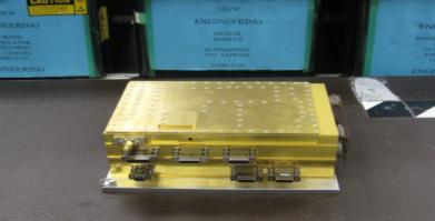
9 Completed OLI Instrument Courtesy of Ball Aerospace & Technologies Corp. Completed OLI Sensor with Electronics 9

10 Thermal Infrared Sensor (TIRS) Collects data for two long-wave spectral bands Provides continuity with one TM/ETM+ thermal band Collects 400 scenes per day using a pushbroom design Coincident with OLI data collection Covers a 185 km swath Provides a 100 m spatial resolution Collects calibration data Space view, internal blackbody, vicarious calibration sites, geometric super sites 10
11 TIRS and ETM+ Spectral Bands L7 ETM+ Thermal Band LDCM TIRS Band Requirements Band 6 60 m LWIR m LWIR Band m LWIR Band m resolution TIRS requirement deemed sufficient to resolve most centerpivot irrigation fields in U.S. West - typically 400 to 800 m in diameter TIRS design provides for 100 m resolution Landsat 4 & 5 TM s provided 120 m thermal images for a single thermal band Landsat 7 ETM+ provided 60 m thermal images for a single thermal band A two band instrument will enable atmospheric correction so that more accurate surface temperatures can be derived. 11

12 TIRS on LDCM Spacecraft Y Z Deployable Earth Shield (Stowed) Cryocooler Electronics X MEB OLI Quantum well infrared photodetector (QWIP) focal plane array (built at GSFC), at 43K 2-Channel IR spectral imager 10.8 mm and 12 mm Split window atmospheric correction Two full aperture calibration sources Onboard blackbody Space view Calibration every 34 minutes Scene select mirror selects between calibration sources, nadir 185 km ground swath (15 FOV) 100 meter resolution TIRS delivery December year life, Class C instrument 12


13 TIRS Status (1 of 2) Completed Focal Plane Array Telescope Focal Plane Electronics Nearly Completed Scene Select Mechanism Structure Earth Shield Mechanism Cryocooler Main Electronics Box 13 13

14 TIRS Status (2 of 2) Integration and Testing (I&T): Integration: Flight FPA to Flight Telescope - complete Flight FPE integration March 2011 Testing Focus testing complete, meets requirements Interface testing between FPE and MEB testbed complete Initial Calibration March-April 2011 Calibration GSE 14 14
 Including all data sent real time to International Cooperators Data Transmission from an")

15 LDCM Spacecraft 3.14 Tbit Solid-State Recorder (SSR) Including all data sent real time to International Cooperators Data Transmission from an earth-coverage antenna Real-time data received from PIE Play-back data from SSR To three LGN ground stations To International Cooperator ground stations Maneuvers Inclination adjustments and drag make-up keeps ground tracks along WRS-2 paths and equatorial crossing time at 10:00 a.m. Solar and Lunar calibration maneuvers Off-nadir pointing for collection of priority data 15

16 LDCM Spacecraft Status Spacecraft bus I&T underway Initial power on the bus in late January Spacecraft Harness Installed Flight avionics boxes in test OLI Interface Simulator tested with S/C Interface Simulator Flight Battery cells activated 16

17 Ground System Architecture
, USGS EROS, Sioux Falls, SD")
18 Ground System: Landsat Ground Network Receives mission data transmitted from the observatory at three ground stations USGS EROS, Sioux Falls, SD Gilmore Creek, AK Svalbard, Norway Generates mission data files Sends mission data on to the Data Processing and Archive System (DPAS), USGS EROS, Sioux Falls, SD 18

19 International Cooperator Network 19

20 Long Term Acquisition Plan - 8 The Long Term Acquisition Plan (LTAP) defines the OLI and TIRS data collection strategy for LDCM. Optimize data collection capacity of 400 scenes per day out of 800+ land scenes viewed LTAP Parameters Historical cloud climatology Seasonality Begin / End date, Acquire once / always, Base priority values for land, islands, conterminous U.S. Priority schema for non-ltap data collection requests Solar zenith angle constraints Cloud cover predictions (NCEP) Automated cloud cover assessments (DPAS ) 20
21 Standard L1T and L1Gt Data Products LDCM standard Level-1 data products will be consistent with heritage Landsat product specifications OLI and TIRS data will distributed as a combined product. Pixel size:15m/30m/30m Quality Assurance (QA) band will be included Media type: Electronic Product type: Level-1T (precision, terrain correction) Output format: GeoTIFF Map projection: UTM (Polar Stereographic for Antarctica) Datum: WGS84 Orientation: North up Resampling: Cubic convolution 21
 is December")
22 LDCM Master Schedule Launch Readiness Date (LRD) is December 1,

23 Conclusion LDCM (Landsat-8 post commissioning) will continue the Landsat mission for moderate resolution seasonal coverage of the global land mass LDCM is a generational change from earlier Landsats MSS TM ETM+ OLI/TIRS Enhancements in spectral bands, radiometry Rigorous calibration LDCM is on schedule for a 1 December 2012 launch 23
24 Backup Charts 24
25 OLI and ETM+ Spectral Bands L7 ETM+ Bands LDCM OLI Band Requirements 30 m Coastal/Aerosol Band 1 Band 1 30 m Blue m Blue Band 2 Band 2 30 m Green m Green Band 3 Band 3 30 m Red m Red Band 4 Band 4 30 m Near-IR m Near-IR Band 5 Band 5 30 m SWIR m SWIR Band 6 Band 6 60 m LWIR N/A Band 7 30 m SWIR m SWIR Band 7 Band 8 15 m Pan m Pan Band 8 30 m Cirrus Band 9 25


26 Follow the Science Data Flow User Portal 26
27 It All Starts in the Mission Ops Center (MOC) Collection Activity Planning Element (CAPE) Ensures seasonal coverage of global land mass Long Term Acquisition Plan 8 (LTAP8) Accepts external requests for scene collects Data Acquisition Manager International Cooperators, Priority Scenes (including off-nadir), User Requests Delivers daily scene collection requests to MOE 400 scenes per day Mission Operations Element (MOE) Monitors observatory health and safety Plans daily schedule on basis of CAPE scene requests Transmits daily command load to observatory Maintains satellite orbit along World Wide Reference System-Two (WRS-2) ground tracks with 10:00 a.m. equatorial crossing time Plans and commands satellite maneuvers Inclination adjustment and drag make-up maneuvers, solar and lunar calibration maneuvers, off-nadir pointing 27


28 Mission Overview Category 1, Risk Class B Mission (TIRS Risk Class C Instrument) Category 3 L/V LDCM Observatory (OLI, TIRS) S-band SSA 1 kbps Forward 2 or 32 kbps Return TDRSS LDCM Orbit 705 km circular sun sync, 10am DNLT 16-day repeat Alaska Ground Station Gilmore, AK X-band RT Broadcast 384 Mbps X-band Stored Science RT+PB or Mbps S-band CMD uplink 1 or 32 kbps S-band RT downlink 32 kbps S-band combined Stored & RT TLM downlink 1 Mbps Representative IC Canada Landsat Ground Station Sioux Falls, SD Atlas V VAFB NASA GN Wallops Island, VA


29 Spacecraft Components EM Load EM Charge Control Unit (CCU) EM Load Control Unit (LCU) FLT Battery Bus Board FLT Harness EM Integrated Electronics Module (IEM) EM Solid State Recorder (SSR) EM I&T Battery EM FLT RAD750 EM Payload Interface Electronics (PIE) FLT 1553 Coupler FLT OCXO EM AMT (S-Band Transponder) FLT TWTA FLT Propellant Tank FLT 22N Hydrazine Thruster EM RF Filter EM X-Band Transmitter FLT Latch Valve FLT Pressure Transducer 29


30 User Portal Services Browse L1 data DPAS WMS WCS KML RSS Geo Inventory service Network access to inventory Browse overlay LDCM data LDCM browse Science data data feeds Metadata Data search clients & data sharing centers Google Earth et al. WMS Viewers GeoRSS feed readers L0Rp data Widgets Web portals EROS Data Access Tools Mobile devices Map Mashups 30

31 Impact of Free Data LandTrendr: Landsat-based Detection of Trends in Disturbance and Recovery Kennedy and Cohen, Landsat Science Team
32 DPAS Subsystem Overview (1 of 3) Ingest Subsystem Receives science mission data files from LGN stations Decompresses OLI data Processes science mission data to L0Ra data interval-based Sends L0Ra data to Storage and Archive Subsystem Provides L0Ra metadata to the Inventory Provides characterization data and bias parameters to the IAS Storage and Archive Subsystem Provides shared storage to all DPAS subsystems Archive Cache, Internal Cache, Online Cache Provides an archive capability for LDCM mission data Sends mission data files to off-site back-up archive Subsetter Subsystem Spatially subsets L0Ra data to L0Rp data WRS-2 scene-based 32
33 DPAS Subsystem Overview (2 of 3) Image Assessment Subsystem (IAS) Provides a calibration / validation capability for OLI and TIRS Maintains a detailed characterization DB for both instruments Provides various auxiliary datasets (CPF, BPF, RLUT, GCPs) Level 1 Product Generation Subsystem (LPGS) Processes L0Rp data to Level 1 products (nominally L1T) Formats L1/L0Rp products and places them on the online cache Provides L0Rp / Level 1 metadata to the Inventory Generates at least 400 L1T data products per day 33
 L0Ra data that have been spatially subsetted (nominally to WRS-2 framing) Level 1 Terrain (L1T) / Systematic Terrain (L1Gt) Level 0Rp data that")
34 DPAS Processing Levels Level 0 Reformatted Archive (L0Ra) Mission data files that have been combined, corrected, and processed into a single interval for long-term storage by the DPAS Internal; not a distributed product Level 0 Reformatted Product (L0Rp) L0Ra data that have been spatially subsetted (nominally to WRS-2 framing) Level 1 Terrain (L1T) / Systematic Terrain (L1Gt) Level 0Rp data that have radiometric and geometric corrections applied Digital Elevation Model (DEM) is applied to remove the effects of terrain on the corrected imagery A precision model is generated by registering the data to a ground control library to provide a common geodetic reference base (L1T) only systematic correction when ground control unavailable (L1Gt) Full resolution Browse Images 34
35 DPAS Subsystem Overview (3 of 3) Inventory Subsystem Maintains metadata for L0Ra, L0Rp, L1Gt, and L1T datasets Provides an interface to query / update inventory metadata User Portal Subsystem Provides a search, order, and data distribution capability Disseminates auxiliary information to LDCM data users Distributes at least 1250 L1T scenes per day for first two years of mission ops, at least 3500 L1T scenes per day in subsequent years At no cost to requestor/user Available to general public on non-discriminatory basis Provides multiple, standards-based, data access services 35
36 Salient Characteristics of the LDCM (1 of 2) Continuity mandate is fulfilled Spectral bands comparable to TM and ETM+ sensors Data collection along WRS-2 paths with identical 185 km swath width LTAP-8 will ensure global coverage of land mass on seasonal basis LDCM data will be backward compatible with data from previous Landsat sensors long term retrospective studies to trend change over time Capabilities are advanced Two new reflective bands, refined band widths avoid atmospheric absorption features, two thermal bands facilitate atmospheric correction Improved radiometric performance dynamic range, signal-to-noise ratios More data 400 scenes per day lead to improved global coverage 36
37 Salient Characteristics of the LDCM (2 of 2) Rigorous calibration is maintained Image Assessment System Internal cal lamps, solar panel, lunar maneuvers, deep space view, black body, vicarious field calibration, geographic super sites Cal/Val Team of leading experts LDCM data will be forward compatible with data from commercial and international satellites (e.g. Sentinel-2) TM/ETM+/OLI spectral bands are standard Landsat sets the standard for rigorous calibration and systematic, comprehensive data collection Data will be free to the general public Capabilities to process and analyze large volumes of Landsat data are advancing rapidly for long term and broad area studies 37
38 Mission Statement The LDCM, consistent with U.S. law and government policy, will continue the acquisition, archiving, and distribution of moderate-resolution multispectral imagery affording global, synoptic, and repetitive coverage of the earth's land surface at a scale where natural and humaninduced changes can be detected, differentiated, characterized, and monitored over time. 38
The Next Landsat The Landsat Data Continuity Mission (LDCM) ASPRS Potomac Region Tour of GSFC March 12, 2010
 ASPRS Potomac Region Tour of GSFC March 12, 2010") LDCM SRR/MDR/PNAR 22-24 April 2008 The Next Landsat The Landsat Data Continuity Mission (LDCM) ASPRS Potomac Region Tour of GSFC March 12, 2010 Jim Irons Landsat Data Continuity Mission (LDCM) Project
LDCM SRR/MDR/PNAR 22-24 April 2008 The Next Landsat The Landsat Data Continuity Mission (LDCM) ASPRS Potomac Region Tour of GSFC March 12, 2010 Jim Irons Landsat Data Continuity Mission (LDCM) Project
Satellite Remote Sensing: Earth System Observations
 Satellite Remote Sensing: Earth System Observations Land surface Water Atmosphere Climate Ecosystems 1 EOS (Earth Observing System) Develop an understanding of the total Earth system, and the effects of
29 th Annual Louisiana RS/GIS Workshop April 23, 2013 Cajundome Convention Center Lafayette, Louisiana
 Landsat Data Continuity Mission 29 th Annual Louisiana RS/GIS Workshop April 23, 2013 Cajundome Convention Center Lafayette, Louisiana http://landsat.usgs.gov/index.php# Landsat 5 Sets Guinness World Record
Status of Landsat 5, Landsat 7, and the Landsat Data Continuity Mission
 LDCM SRR/MDR/PNAR 22-24 April 2008 Status of Landsat 5, Landsat 7, and the Landsat Data Continuity Mission Spring Land Cover / Land Use Change Science Team Meeting Bethesda, Maryland Jim Irons Landsat
National Aeronautics and Space Administration. Landsat Update. Jeff Masek, NASA GSFC Jim Irons, NASA GSFC. April 3, 2012 LCLUC Meeting.
 National Aeronautics and Space Administration Landsat Update Jeff Masek, NASA GSFC Jim Irons, NASA GSFC April 3, 2012 LCLUC Meeting www.nasa.gov Agenda Landsat-5/7 Update LDCM / Landsat-8 Mission Status
Landsat 8. Snabba leveranser av bilder till användarna. Lars-Åke Edgardh. tisdag 9 april 13
 Landsat 8 Snabba leveranser av bilder till användarna Lars-Åke Edgardh Keystone A single system for: Many sensors Many types of clients Hides the complexity of sensors. Specialised on: Services High volume
Update on Landsat Program and Landsat Data Continuity Mission
 Update on Landsat Program and Landsat Data Continuity Mission Dr. Jeffrey Masek LDCM Deputy Project Scientist NASA GSFC, Code 923 November 21, 2002 Draft LDCM Implementation Phase RFP Overview Page 1 Celebrate!
Remote Sensing of Environment
 Remote Sensing of Environment 122 (2012) 11 21 Contents lists available at SciVerse ScienceDirect Remote Sensing of Environment journal homepage: www.elsevier.com/locate/rse The next Landsat satellite:
Landsat and LDCM Status
 Landsat and LDCM Status Tom Loveland USGS Earth Resources Observation and Science (EROS) Center Sioux Falls, SD May 1, 2008 U.S. Department of the Interior U.S. Geological Survey Landsat Data Continuity
SDCG-5 Session 2. Landsat 7/8 status and 2013 Implementation Plan (Element 1)
") Session 2 Landsat 7/8 status and 2013 Implementation Plan (Element 1) Gene Fosnight Mission Landsat Launch and commissioning Landsat 7 Operational: since 15 April 1999 Expected life time:; anticipate decommissioning
Session 2 Landsat 7/8 status and 2013 Implementation Plan (Element 1) Gene Fosnight Mission Landsat Launch and commissioning Landsat 7 Operational: since 15 April 1999 Expected life time:; anticipate decommissioning
LANDSAT 8 (L8) DATA USERS HANDBOOK
 DATA USERS HANDBOOK") LSDS-1574 Department of the Interior U.S. Geological Survey LANDSAT 8 (L8) DATA USERS HANDBOOK June 2015 Any use of trade, firm, or product names is for descriptive purposes only and does not imply endorsement
LSDS-1574 Department of the Interior U.S. Geological Survey LANDSAT 8 (L8) DATA USERS HANDBOOK June 2015 Any use of trade, firm, or product names is for descriptive purposes only and does not imply endorsement
The Landsat Legacy: Monitoring a Changing Earth. U.S. Department of the Interior U.S. Geological Survey
 The Landsat Legacy: Monitoring a Changing Earth U.S. Department of the Interior U.S. Geological Survey Tom Loveland March 17, 2001 Landsat Science Mission Change is occurring at rates unprecedented in
The Road to Launching the Landsat Data Continuity Mission
 LDCM SRR/MDR/PNAR 22-24 April 2008 The Road to Launching the Landsat Data Continuity Mission James R. Irons LDCM Project Scientist William R. Ochs LDCM Project Manager Del T. Jenstrom LDCM Deputy Project
LANDSAT 8 (L8) DATA USERS HANDBOOK
 DATA USERS HANDBOOK") LSDS-1574 Department of the Interior U.S. Geological Survey LANDSAT 8 (L8) DATA USERS HANDBOOK October 2018 LANDSAT 8 (L8) DATA USERS HANDBOOK October 2018 Approved By: K. Zanter Date LSDS CCB Chair USGS
LSDS-1574 Department of the Interior U.S. Geological Survey LANDSAT 8 (L8) DATA USERS HANDBOOK October 2018 LANDSAT 8 (L8) DATA USERS HANDBOOK October 2018 Approved By: K. Zanter Date LSDS CCB Chair USGS
USGS Welcome. 38 th CEOS Working Group on Calibration and Validation Plenary (WGCV-38)
") Landsat 5 USGS Welcome Prepared for 38 th CEOS Working Group on Calibration and Validation Plenary (WGCV-38) Presenter Tom Cecere International Liaison USGS Land Remote Sensing Program Elephant Butte Reservoir
Landsat 5 USGS Welcome Prepared for 38 th CEOS Working Group on Calibration and Validation Plenary (WGCV-38) Presenter Tom Cecere International Liaison USGS Land Remote Sensing Program Elephant Butte Reservoir
NON-PHOTOGRAPHIC SYSTEMS: Multispectral Scanners Medium and coarse resolution sensor comparisons: Landsat, SPOT, AVHRR and MODIS
 NON-PHOTOGRAPHIC SYSTEMS: Multispectral Scanners Medium and coarse resolution sensor comparisons: Landsat, SPOT, AVHRR and MODIS CLASSIFICATION OF NONPHOTOGRAPHIC REMOTE SENSORS PASSIVE ACTIVE DIGITAL
Sentinel-2 Products and Algorithms
 Sentinel-2 Products and Algorithms Ferran Gascon (Sentinel-2 Data Quality Manager) Workshop Preparations for Sentinel 2 in Europe, Oslo 26 November 2014 Sentinel-2 Mission Mission Overview Products and
Lesson 3: Working with Landsat Data
 Lesson 3: Working with Landsat Data Lesson Description The Landsat Program is the longest-running and most extensive collection of satellite imagery for Earth. These datasets are global in scale, continuously
The studies began when the Tiros satellites (1960) provided man s first synoptic view of the Earth s weather systems.
 provided man s first synoptic view of the Earth s weather systems.") Remote sensing of the Earth from orbital altitudes was recognized in the mid-1960 s as a potential technique for obtaining information important for the effective use and conservation of natural resources.
Remote sensing of the Earth from orbital altitudes was recognized in the mid-1960 s as a potential technique for obtaining information important for the effective use and conservation of natural resources.
PLANET IMAGERY PRODUCT SPECIFICATIONS PLANET.COM
 PLANET IMAGERY PRODUCT SPECIFICATIONS SUPPORT@PLANET.COM PLANET.COM LAST UPDATED JANUARY 2018 TABLE OF CONTENTS LIST OF FIGURES 3 LIST OF TABLES 4 GLOSSARY 5 1. OVERVIEW OF DOCUMENT 7 1.1 Company Overview
USGS Report to the CEOS WGCV 36 May 13 17, 2013
 USGS Report to the CEOS WGCV 36 May 13 17, 2013 Shanghai, China Greg Stensaas USGS U.S. Department of the Interior U.S. Geological Survey LDCM Successful Lunch! Contributors: The slides in this presentation
RADIOMETRIC CHARACTERIZATION AND PERFORMANCE ASSESSMENT OF THE ALI USING BULK TRENDED DATA
 RADIOMETRIC CHARACTERIZATION AND PERFORMANCE ASSESSMENT OF THE ALI USING BULK TRENDED DATA Tim Ruggles*, Imaging Engineer Dennis Helder*, Director Image Processing Laboratory, Department of Electrical
GEOMETRIC PERFORMANCE COMPARISON BETWEEN THE OLI AND THE ETM+ INTRODUCTION
 GEOMETRIC PERFORMANCE COMPARISON BETWEEN THE OLI AND THE ETM+ James Storey, Michael Choate Stinger Ghaffarian Technologies, contractor to USGS EROS, Sioux Falls, SD Work performed under USGS Contract Number
WGISS-42 USGS Agency Report
 WGISS-42 USGS Agency Report U.S. Department of the Interior U.S. Geological Survey Kristi Kline USGS EROS Center Major Activities Landsat Archive/Distribution Changes Land Change Monitoring, Assessment,
On-Orbit Radiometric Performance of the Landsat 8 Thermal Infrared Sensor. External Editors: James C. Storey, Ron Morfitt and Prasad S.
 Remote Sens. 2014, 6, 11753-11769; doi:10.3390/rs61211753 OPEN ACCESS remote sensing ISSN 2072-4292 www.mdpi.com/journal/remotesensing Article On-Orbit Radiometric Performance of the Landsat 8 Thermal
MRLC 2001 IMAGE PREPROCESSING PROCEDURE
 MRLC 2001 IMAGE PREPROCESSING PROCEDURE The core dataset of the MRLC 2001 database consists of Landsat 7 ETM+ images. Image selection is based on vegetation greenness profiles defined by a multi-year normalized
Status of MODIS, VIIRS, and OLI Sensors
 Status of MODIS, VIIRS, and OLI Sensors Xiaoxiong (Jack) Xiong, Jim Butler, and Brian Markham Code 618.0 NASA/GSFC, Greenbelt, MD 20771, USA Acknowledgements: NASA MODIS Characterization Support Team (MCST)
Remote Sensing of the Environment An Earth Resource Perspective John R. Jensen Second Edition
 Remote Sensing of the Environment An Earth Resource Perspective John R. Jensen Second Edition Pearson Education Limited Edinburgh Gate Harlow Essex CM20 2JE England and Associated Companies throughout
PLANET IMAGERY PRODUCT SPECIFICATION: PLANETSCOPE & RAPIDEYE
 PLANET IMAGERY PRODUCT SPECIFICATION: PLANETSCOPE & RAPIDEYE LAST UPDATED FEBRUARY 2017 SALES@PLANET.COM PLANET.COM Table of Contents LIST OF FIGURES 3 LIST OF TABLES 3 GLOSSARY 5 1. OVERVIEW OF DOCUMENT
Lecture 6: Multispectral Earth Resource Satellites. The University at Albany Fall 2018 Geography and Planning
 Lecture 6: Multispectral Earth Resource Satellites The University at Albany Fall 2018 Geography and Planning Outline SPOT program and other moderate resolution systems High resolution satellite systems
9/12/2011. Training Course Remote Sensing Basic Theory & Image Processing Methods September 2011
 Training Course Remote Sensing Basic Theory & Image Processing Methods 19 23 September 2011 Popular Remote Sensing Sensors & their Selection Michiel Damen (September 2011) damen@itc.nl 1 Overview Low resolution
GMES Sentinel-2. The Optical High Resolution Mission for GMES Operational Services
 GMES Sentinel-2 The Optical High Resolution Mission for GMES Operational Services Philippe Martimort GMES Sentinel-2 Mission and Payload Manager, ESA/ESTEC 15 October 2007, AGRISAR Workshop, Noordwijk
# Landsat and Thermal Infrared Imaging
 # Landsat and Thermal Infrared Imaging Terry Arvidson, Julia Barsi, Murzy Jhabvala, Dennis Reuter Introduction The purpose of this chapter is to describe the collection of thermal images by Landsat sensors
Landsat Program. Science Activities. Polar Space Task Group 4 Meeting, NASA/GSFC, Greenbelt, MD
 Landsat Program Science Activities Polar Space Task Group 4 Meeting, NASA/GSFC, Greenbelt, MD Larry Hothem Senior Physical Scientist USGS Land Remote Sensing Program September 30, 2014 USGS Science Mission
Earth Observations from Space U.S. Geological Survey
 Earth Observations from Space U.S. Geological Survey Geography Land Remote Sensing Program Dr. Bryant Cramer April 1, 2009 U.S. Department of the Interior U.S. Geological Survey USGS Landsat Historical
CubeSat Integration into the Space Situational Awareness Architecture
 CubeSat Integration into the Space Situational Awareness Architecture Keith Morris, Chris Rice, Mark Wolfson Lockheed Martin Space Systems Company 12257 S. Wadsworth Blvd. Mailstop S6040 Littleton, CO
LANDSAT 8 Level 1 Product Performance
 Réf: IDEAS-TN-10-CyclicReport LANDSAT 8 Level 1 Product Performance Cyclic Report Month/Year: May 2015 Date: 25/05/2015 Issue/Rev:1/0 1. Scope of this document On May 30, 2013, data from the Landsat 8
CIRiS: Compact Infrared Radiometer in Space August, 2017
 1 CIRiS: Compact Infrared Radiometer in Space August, 2017 David Osterman PI, CIRiS Mission Presented by Hansford Cutlip 10/8/201 7 Overview of the CIRiS instrument and mission The CIRiS instrument is
NORMALIZING ASTER DATA USING MODIS PRODUCTS FOR LAND COVER CLASSIFICATION
 NORMALIZING ASTER DATA USING MODIS PRODUCTS FOR LAND COVER CLASSIFICATION F. Gao a, b, *, J. G. Masek a a Biospheric Sciences Branch, NASA Goddard Space Flight Center, Greenbelt, MD 20771, USA b Earth
Introduction of Satellite Remote Sensing
 Introduction of Satellite Remote Sensing Spatial Resolution (Pixel size) Spectral Resolution (Bands) Resolutions of Remote Sensing 1. Spatial (what area and how detailed) 2. Spectral (what colors bands)
Compact High Resolution Imaging Spectrometer (CHRIS) siraelectro-optics
 siraelectro-optics") Compact High Resolution Imaging Spectrometer (CHRIS) Mike Cutter (Mike_Cutter@siraeo.co.uk) Summary CHRIS Instrument Design Instrument Specification & Performance Operating Modes Calibration Plan Data
Compact High Resolution Imaging Spectrometer (CHRIS) Mike Cutter (Mike_Cutter@siraeo.co.uk) Summary CHRIS Instrument Design Instrument Specification & Performance Operating Modes Calibration Plan Data
MODULE 2 Sensors and Platforms
 MODULE 2 Sensors and Platforms Eric C. Wood, USGS / EROS Kim E. Keith, CEOS SEO (NASA) March 25, 2013 (Week #6) Outline of Presentation Introduction Satellite Earth orbits Mission operations overview Sensors
Landsat 8, Level 1 Product Performance Cyclic Report January 2017
 Landsat 8, Level 1 Product Performance Cyclic Report January 2017 Author(s) : Sébastien Saunier (IDEAS+, Telespazio VEGA) Amy Northrop (IDEAS+, Telespazio VEGA) IDEAS+-VEG-OQC-REP-2647 Issue January 2017
Landsat Products, Algorithms and Processing (MSS, TM & ETM+)
") Landsat Products, Algorithms and Processing Author(s) : Sébastien Saunier (Magellium) Amy Northrop, Sam Lavender (Telespazio VEGA UK) IDEAS+-MAG-SRV-REP-2266 7 May 2015 Page 2 of 13 AMENDMENT RECORD SHEET
Landsat Products, Algorithms and Processing Author(s) : Sébastien Saunier (Magellium) Amy Northrop, Sam Lavender (Telespazio VEGA UK) IDEAS+-MAG-SRV-REP-2266 7 May 2015 Page 2 of 13 AMENDMENT RECORD SHEET
HEMERA Constellation of passive SAR-based micro-satellites for a Master/Slave configuration
 HEMERA Constellation of passive SAR-based micro-satellites for a Master/Slave HEMERA Team Members: Andrea Bellome, Giulia Broggi, Luca Collettini, Davide Di Ienno, Edoardo Fornari, Leandro Lucchese, Andrea
Landsat 8, Level 1 Product Performance Cyclic Report November 2016
 Landsat 8, Level 1 Product Performance Cyclic Report November 2016 Author(s) : Sébastien Saunier (IDEAS+, Telespazio VEGA) Amy Northrop (IDEAS+, Telespazio VEGA) IDEAS+-VEG-OQC-REP-2647 Issue November
Landsat 8, Level 1 Product Performance Cyclic Report July 2016
 Landsat 8, Level 1 Product Performance Cyclic Report July 2016 Author(s) : Sébastien Saunier (IDEAS+, Telespazio VEGA) Amy Northrop (IDEAS+, Telespazio VEGA) IDEAS+-VEG-OQC-REP-2647 Issue July 2016 1 September
An Introduction to Remote Sensing & GIS. Introduction
 An Introduction to Remote Sensing & GIS Introduction Remote sensing is the measurement of object properties on Earth s surface using data acquired from aircraft and satellites. It attempts to measure something
W-Band Satellite Transmission in the WAVE Mission
 W-Band Satellite Transmission in the WAVE Mission A. Jebril, M. Lucente, M. Ruggieri, T. Rossi University of Rome-Tor Vergata, Dept. of Electronic Engineering, Via del Politecnico 1, 00133 Rome - Italy
Mission requirements and satellite overview
 Mission requirements and satellite overview E. BOUSSARIE 1 Dual concept Users need Defence needs Fulfil the Defence needs on confidentiality and security Civilian needs Fulfillment of the different needs
Japan's Greenhouse Gases Observation from Space
 1 Workshop on EC CEOS Priority on GHG Monitoring Japan's Greenhouse Gases Observation from Space 18 June, 2018@Ispra, Italy Masakatsu NAKAJIMA Japan Aerospace Exploration Agency Development and Operation
Global Land Survey 2005
 Global Land Survey 2005 Jeff Masek, Shannon Franks, Terry Arvidson NASA GSFC Rachel Headley, Steve Covington USGS EROS April, 2008 1 Global Land Survey (GLS 2005) Follow-on to the GeoCover orthorectified
Kazuhiro TANAKA GCOM project team/jaxa April, 2016
 Kazuhiro TANAKA GCOM project team/jaxa April, 216 @ SPIE Asia-Pacific 216 at New Dehli, India 1 http://suzaku.eorc.jaxa.jp/gcom_c/index_j.html GCOM mission and satellites SGLI specification and IRS overview
CHAPTER 7: Multispectral Remote Sensing
 CHAPTER 7: Multispectral Remote Sensing REFERENCE: Remote Sensing of the Environment John R. Jensen (2007) Second Edition Pearson Prentice Hall Overview of How Digital Remotely Sensed Data are Transformed
The availability of cloud free Landsat TM and ETM+ land observations and implications for global Landsat data production
 14475 The availability of cloud free Landsat TM and ETM+ land observations and implications for global Landsat data production *V. Kovalskyy, D. Roy (South Dakota State University) SUMMARY The NASA funded
US Commercial Imaging Satellites
 US Commercial Imaging Satellites In the early 1990s, Russia began selling 2-meter resolution product from its archives of collected spy satellite imagery. Some of this product was down-sampled to provide
Landsat 8, Level 1 Product Performance Cyclic Report February 2017
 Landsat 8, Level 1 Product Performance Cyclic Report February 2017 Author(s) : Sébastien Saunier (IDEAS+, Telespazio VEGA) Amy Northrop (IDEAS+, Telespazio VEGA) IDEAS+-VEG-OQC-REP-2647 Issue February
PLANET IMAGERY PRODUCT SPECIFICATION: PLANETSCOPE & RAPIDEYE
 PLANET IMAGERY PRODUCT SPECIFICATION: PLANETSCOPE & RAPIDEYE LAST UPDATED OCTOBER 2016 SALES@PLANET.COM PLANET.COM Table of Contents LIST OF FIGURES 3 LIST OF TABLES 3 GLOSSARY 5 1. OVERVIEW OF DOCUMENT
A CubeSat-Based Optical Communication Network for Low Earth Orbit
 A CubeSat-Based Optical Communication Network for Low Earth Orbit Richard Welle, Alexander Utter, Todd Rose, Jerry Fuller, Kristin Gates, Benjamin Oakes, and Siegfried Janson The Aerospace Corporation
FORMOSAT-5. - Launch Campaign-
 1 FORMOSAT-5 - Launch Campaign- FORMOSAT-5 Launch Campaign 2 FORMOSAT-5 Launch Campaign Launch Date: 2017.08.24 U.S. Pacific Time Activities 11:50-12:23 Launch Window 13:30-16:00 Reception 3 FORMOSAT-5
GEOMETRIC RECTIFICATION OF EUROPEAN HISTORICAL ARCHIVES OF LANDSAT 1-3 MSS IMAGERY
 GEOMETRIC RECTIFICATION OF EUROPEAN HISTORICAL ARCHIVES OF LANDSAT -3 MSS IMAGERY Torbjörn Westin Satellus AB P.O.Box 427, SE-74 Solna, Sweden tw@ssc.se KEYWORDS: Landsat, MSS, rectification, orbital model
Remote Sensing Platforms
 Types of Platforms Lighter-than-air Remote Sensing Platforms Free floating balloons Restricted by atmospheric conditions Used to acquire meteorological/atmospheric data Blimps/dirigibles Major role - news
OVERVIEW OF KOMPSAT-3A CALIBRATION AND VALIDATION
 OVERVIEW OF KOMPSAT-3A CALIBRATION AND VALIDATION DooChun Seo 1, GiByeong Hong 1, ChungGil Jin 1, DaeSoon Park 1, SukWon Ji 1 and DongHan Lee 1 1 KARI(Korea Aerospace Space Institute), 45, Eoeun-dong,
Using Freely Available. Remote Sensing to Create a More Powerful GIS
 Using Freely Available Government Data and Remote Sensing to Create a More Powerful GIS All rights reserved. ENVI, E3De, IAS, and IDL are trademarks of Exelis, Inc. All other marks are the property of
Landsat 8, Level 1 Product Performance Cyclic Report August 2017
 Landsat 8, Level 1 Product Performance Cyclic Report August 2017 Author(s) : Sébastien Saunier (IDEAS+, Telespazio VEGA) Amy Beaton (IDEAS+, Telespazio VEGA) IDEAS+-VEG-OQC-REP-2647 Issue August 2017 21
ASSESSMENT BY ESA OF GCOS CLIMATE MONITORING PRINCIPLES FOR GMES
 Prepared by ESA Agenda Item: III.5 Discussed in WG3 ASSESSMENT BY ESA OF GCOS CLIMATE MONITORING PRINCIPLES FOR GMES The ESA Sentinel missions are being designed for the GMES services, with special emphasis
TEMPORAL ANALYSIS OF MULTI EPOCH LANDSAT GEOCOVER IMAGES IN ZONGULDAK TESTFIELD
 TEMPORAL ANALYSIS OF MULTI EPOCH LANDSAT GEOCOVER IMAGES IN ZONGULDAK TESTFIELD Şahin, H. a*, Oruç, M. a, Büyüksalih, G. a a Zonguldak Karaelmas University, Zonguldak, Turkey - (sahin@karaelmas.edu.tr,
EPS Bridge Low-Cost Satellite
 EPS Bridge Low-Cost Satellite Results of a Concept Study being performed for Dr. Hendrik Lübberstedt OHB-System AG OpSE Workshop Walberberg 8th November 2005 EPS Bridge Key System Requirements Minimum
Landsat and the Data Continuity Mission
 Carl E. Behrens Specialist in Energy Policy May 22, 2009 Congressional Research Service CRS Report for Congress Prepared for Members and Committees of Congress 7-5700 www.crs.gov R40594 Summary The U.S.
Introduction to Remote Sensing
 Introduction to Remote Sensing Spatial, spectral, temporal resolutions Image display alternatives Vegetation Indices Image classifications Image change detections Accuracy assessment Satellites & Air-Photos
Landsat 8 Operational Land Imager On-Orbit Geometric Calibration and Performance
 Remote Sens. 2014, 6, 11127-11152; doi:10.3390/rs61111127 Article OPEN ACCESS remote sensing ISSN 2072-4292 www.mdpi.com/journal/remotesensing Landsat 8 Operational Land Imager On-Orbit Geometric Calibration
ASTER and USGS EROS Emergency Imaging for Hurricane Disasters
 ASTER and USGS EROS Emergency Imaging for Hurricane Disasters By Kenneth A. Duda and Michael Abrams Satellite images have been extremely useful in a variety of emergency response activities, including
Radiometric Use of WorldView-3 Imagery. Technical Note. 1 WorldView-3 Instrument. 1.1 WorldView-3 Relative Radiance Response
 Radiometric Use of WorldView-3 Imagery Technical Note Date: 2016-02-22 Prepared by: Michele Kuester This technical note discusses the radiometric use of WorldView-3 imagery. The first two sections briefly
Outline. Introduction. Introduction: Film Emulsions. Sensor Systems. Types of Remote Sensing. A/Prof Linlin Ge. Photographic systems (cf(
 GMAT x600 Remote Sensing / Earth Observation Types of Sensor Systems (1) Outline Image Sensor Systems (i) Line Scanning Sensor Systems (passive) (ii) Array Sensor Systems (passive) (iii) Antenna Radar
The Nemo Bus: A Third Generation Nanosatellite Bus for Earth Monitoring and Observation
 The Nemo Bus: A Third Generation Nanosatellite Bus for Earth Monitoring and Observation FREDDY M. PRANAJAYA Manager, Advanced Systems Group S P A C E F L I G H T L A B O R A T O R Y University of Toronto
DESIS Applications & Processing Extracted from Teledyne & DLR Presentations to JACIE April 14, Ray Perkins, Teledyne Brown Engineering
 DESIS Applications & Processing Extracted from Teledyne & DLR Presentations to JACIE April 14, 2016 Ray Perkins, Teledyne Brown Engineering 1 Presentation Agenda Imaging Spectroscopy Applications of DESIS
Global Land Survey Activities and Land Cover Analysis from Landsat
 Global Land Survey Activities and Land Cover Analysis from Landsat Shannon Franks, SGT/NASA Jeffrey G. Masek, NASA GSFC Garik Gutman, NASA HQ Rachel Headley, USGS CODATA, October 25, 2010 Background the
RECONNAISSANCE PAYLOADS FOR RESPONSIVE SPACE
 3rd Responsive Space Conference RS3-2005-5004 RECONNAISSANCE PAYLOADS FOR RESPONSIVE SPACE Charles Cox Stanley Kishner Richard Whittlesey Goodrich Optical and Space Systems Division Danbury, CT Frederick
Band to Band Calibration and Relative Gain Analysis of Satellite Sensors Using Deep Convective Clouds
 South Dakota State University Open PRAIRIE: Open Public Research Access Institutional Repository and Information Exchange Theses and Dissertations 2015 Band to Band Calibration and Relative Gain Analysis
Aral Sea profile Selection of area 24 February April May 1998
 250 km Aral Sea profile 1960 1960 1985 1986 1987 1988 1989 1990 1991 1992 1993 1994 1995 1996 1997 1998 2010? Selection of area Area of interest Kzyl-Orda Dried seabed 185 km Syrdarya river Aral Sea Salt
On the use of water color missions for lakes in 2021
 Lakes and Climate: The Role of Remote Sensing June 01-02, 2017 On the use of water color missions for lakes in 2021 Cédric G. Fichot Department of Earth and Environment 1 Overview 1. Past and still-ongoing
OPAL Optical Profiling of the Atmospheric Limb
 OPAL Optical Profiling of the Atmospheric Limb Alan Marchant Chad Fish Erik Stromberg Charles Swenson Jim Peterson OPAL STEADE Mission Storm Time Energy & Dynamics Explorers NASA Mission of Opportunity
Indian Remote Sensing Satellites
 Resourcesat-1 Cartosat-1 Indian Remote Sensing Satellites -Current & Future Missions - Presented by: Timothy J. Puckorius Chairman & CEO EOTec 1 Presentation Topics Who is EOTec India s Earth Observation
Satellite/Aircraft Imaging Systems Imaging Sensors Standard scanner designs Image data formats
 CEE 6150: Digital Image Processing 1 Satellite/Aircraft Imaging Systems Imaging Sensors Standard scanner designs Image data formats CEE 6150: Digital Image Processing 2 CEE 6150: Digital Image Processing
DESIGN AND IMPLEMENTATION OF THE NEXT GENERATION LANDSAT SATELLITE COMMUNICATIONS SYSTEM
 DESIGN AND IMPLEMENTATION OF THE NEXT GENERATION LANDSAT SATELLITE COMMUNICATIONS SYSTEM Grant Mah 1, Mike O'Brien 2, Howard Garon 3, Claire Mott 4, Alan Ames 4, Ken Dearth 5, 1. United States Geological
Radiometric performance of Second Generation Global Imager (SGLI) using integrating sphere
 using integrating sphere") Radiometric performance of Second Generation Global Imager (SGLI) using integrating sphere Taichiro Hashiguchi, Yoshihiko Okamura, Kazuhiro Tanaka, Yukinori Nakajima Japan Aerospace Exploration Agency
Radiometric performance of Second Generation Global Imager (SGLI) using integrating sphere Taichiro Hashiguchi, Yoshihiko Okamura, Kazuhiro Tanaka, Yukinori Nakajima Japan Aerospace Exploration Agency
Microwave Radiometers for Small Satellites
 Microwave Radiometers for Small Satellites Gregory Allan, Ayesha Hein, Zachary Lee, Weston Marlow, Kerri Cahoy MIT STAR Laboratory Daniel Cousins, William J. Blackwell MIT Lincoln Laboratory This work
Geo/SAT REMOTE SENSING: LANDSAT PROGRAM
 Geo/SAT 2 REMOTE SENSING: LANDSAT PROGRAM Paul R. Baumann Professor of Geography (Emeritus) State University of New York College at Oneonta Oneonta, New York 13820 USA Remote Sensing: Landsat Program Page
An Introduction to Geomatics. Prepared by: Dr. Maher A. El-Hallaq خاص بطلبة مساق مقدمة في علم. Associate Professor of Surveying IUG
 An Introduction to Geomatics خاص بطلبة مساق مقدمة في علم الجيوماتكس Prepared by: Dr. Maher A. El-Hallaq Associate Professor of Surveying IUG 1 Airborne Imagery Dr. Maher A. El-Hallaq Associate Professor
Satellite data processing and analysis: Examples and practical considerations
 Satellite data processing and analysis: Examples and practical considerations Dániel Kristóf Ottó Petrik, Róbert Pataki, András Kolesár International LCLUC Regional Science Meeting in Central Europe Sopron,
ASTER GDEM Readme File ASTER GDEM Version 1
 I. Introduction ASTER GDEM Readme File ASTER GDEM Version 1 The Advanced Spaceborne Thermal Emission and Reflection Radiometer (ASTER) Global Digital Elevation Model (GDEM) was developed jointly by the
PLANET: IMAGING THE EARTH EVERY DAY
 PLANET: IMAGING THE EARTH EVERY DAY Benjamin Trigona-Harany Mailiao Refinery, Taiwan May 31, 2016 To image the whole world every day, making change visible, accessible and actionable. HONG KONG January
White Paper. Medium Resolution Images and Clutter From Landsat 7 Sources. Pierre Missud
 White Paper Medium Resolution Images and Clutter From Landsat 7 Sources Pierre Missud Medium Resolution Images and Clutter From Landsat7 Sources Page 2 of 5 Introduction Space technologies have long been
National Aeronautics and Space Administration Jet Propulsion Laboratory California Institute of Technology
 QuikSCAT Mission Status QuikSCAT Follow-on Mission 2 QuikSCAT instrument and spacecraft are healthy, but aging June 19, 2009 will be the 10 year launch anniversary We ve had two significant anomalies during
Multispectral Scanners for Wildland Fire Assessment NASA Ames Research Center Earth Science Division. Bruce Coffland U.C.
 Multispectral Scanners for Wildland Fire Assessment NASA Earth Science Division Bruce Coffland U.C. Santa Cruz Slide Fire Burn Area (MASTER/B200) R 2.2um G 0.87um B 0.65um Airborne Science & Technology
Sources of Geographic Information
 Sources of Geographic Information Data properties: Spatial data, i.e. data that are associated with geographic locations Data format: digital (analog data for traditional paper maps) Data Inputs: sampled
Comprehensive Vicarious Calibration and Characterization of a Small Satellite Constellation Using the Specular Array Calibration (SPARC) Method
 Method") This document does not contain technology or Technical Data controlled under either the U.S. International Traffic in Arms Regulations or the U.S. Export Administration Regulations. Comprehensive Vicarious
This document does not contain technology or Technical Data controlled under either the U.S. International Traffic in Arms Regulations or the U.S. Export Administration Regulations. Comprehensive Vicarious
Cross Track Infrared Sounder (CrIS) Flight Model 1 Test Results
 Flight Model 1 Test Results") May 6, 2009 Ronald Glumb, Joseph P. Predina, Robert Hookman, Chris Ellsworth, John Bobilya, Steve Wells, Lawrence Suwinski, Rebecca Frain, and Larry Crawford For Publication at the ASS-FTS14 Conference
May 6, 2009 Ronald Glumb, Joseph P. Predina, Robert Hookman, Chris Ellsworth, John Bobilya, Steve Wells, Lawrence Suwinski, Rebecca Frain, and Larry Crawford For Publication at the ASS-FTS14 Conference
Planet Labs Inc 2017 Page 2
 SKYSAT IMAGERY PRODUCT SPECIFICATION: ORTHO SCENE LAST UPDATED JUNE 2017 SALES@PLANET.COM PLANET.COM Disclaimer This document is designed as a general guideline for customers interested in acquiring Planet
MAPS AND SATELLITE IMAGES TOOLS FOR AN EFFECTIVE MANAGEMENT OF THE HISTORIC CENTER OF SIGHISOARA, AN UNESCO WORLD HERITAGE SITE
 Journal of Young Scientist, Volume VI, 2018 ISSN 2344-1283; ISSN CD-ROM 2344-1291; ISSN Online 2344-1305; ISSN-L 2344 1283 MAPS AND SATELLITE IMAGES TOOLS FOR AN EFFECTIVE MANAGEMENT OF THE HISTORIC CENTER