Lecture # 7 Coordinate systems and georeferencing
|
|
|
- Garey Williams
- 6 years ago
- Views:
Transcription
1 Lecture # 7 Coordinate systems and georeferencing
2 Coordinate Systems Coordinate reference on a plane Coordinate reference on a sphere
3 Coordinate reference on a plane Coordinates are a convenient way of locating points on a two-dimensional plane Two usually employed systems are Rectangular cartesian coordinate system that makes use of linear measurements in two directions from a pair of fixed axes, usually orthogonal (or rectangular) Polar coordinate position defined with reference to the origin or pole, the polar axis, radius vector (distance), and the vectorial angle
4 Cartesian (x,y)
5 Polar coordinates O- origin or pole OA- radius vector QOA- vectorial angle r φ A O Q
6 Coordinate reference on a sphere For unique references for locations on the surface of earth, a system of three dimensional polar coordinates may be used Two orthogonal planes are chosen, which intersect the origin (centre of earth) one plane goes through equator second plane is perpendicular to the equatorial plane (Greenwich, UK, 1884)
7 Referencing location on the earth s surface latitude and longitude reference system Equator Prime Meridian Parallels of Latitude Meridians of Longitude Graticular Network
8 Grids vs. Graticules Graticule - 3 dimensional network of lines that wrap around the earth (lat./long) Grid - flat 2 dimensional network of lines (x, y plane) A grid is on a flat piece of paper, while a graticule is on the round earth
9 Referencing location on the earth s surface latitude φ: angle from the equator to the parallel longitude λ: angle from Greenwich meridian
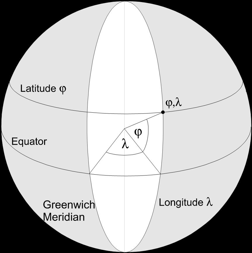

10 Referencing location on the earth s surface
 EQUATOR 0 Lat.")
11 Geographic Coordinate System INTERNATIONAL DATE LINE -180 Longitude NORTH POLE +90 Latitude CENTRAL MERIDIAN LATITUDE LINES (PARALLELS) EQUATOR 0 Lat. LONGITUDE LINES (MERIDIANS)
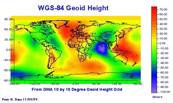
12 Earth Surfaces Ellipsoid or spheroid - smooth mathematical models of the shape of the earth Geoid - Geoid models attempt to represent the surface of the entire earth over both land and ocean as though the surface resulted from gravity alone Topographic surface - the actual surface of the land and sea at some moment in time

13 The earth as a spheroid

14 Ellipsoid Geoid
15
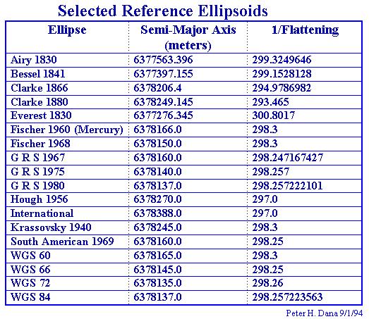
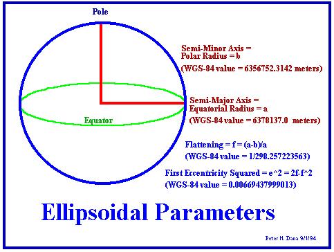
16 Reference Ellipsoid b a Ellipsoidal Parameters a - semi-major axis b - semi-minor axis f = (a-b)/a - flattening used to establish a datum: reference point for large scale mapping
17
18
19 Heights Elevation - Mean Sea Level - the average surface of the oceans. Tidal forces and gravity differences from different locations cause variations of hundreds of meters. Ellipsoid height - the height from the ellipsoid Orthometric height - the height from the geoid.
20 Datums The datum is where zero is, it is where you start measuring from A datum is a mathematical model of the earth we use to calculate the coordinates on any map, chart, or survey system
21 Geodesy Modern geodetic datums range from flat-earth models used for plane surveying to complex models used for international applications which completely describe the size, shape, orientation, gravity field, and angular velocity of the earth Cartography, surveying, navigation, and astronomy all make use of geodetic datums, and the science of geodesy is the central discipline for the topic Referencing geodetic coordinates to the wrong datum can result in position errors of hundreds of meters
22 Geodetic Datums Geodetic datums define the size and shape of the earth and the origin and orientation of the coordinate systems used to map the earth Hundreds of different datums have been used to frame position descriptions since the first estimates of the earth's size were made by Aristotle Datums have evolved from those describing a spherical earth to ellipsoidal models derived from years of satellite measurements
23 Datum Selection Different nations, states, and agencies use different datums as the basis for coordinate systems used to identify positions in geographic information systems, precise positioning systems, and navigation systems. The diversity of datums in use today and the technological advancements that have made possible global positioning measurements with sub-meter accuracies requires careful datum selection and careful conversion between coordinates in different datums
24 Why do the themes on a map need to have the same datum? Datum shift- the coordinates for a point on the Earth s surface in one datum will not match the coordinates from another datum for the same point A shift exists between datums because each datum has a different origin. Sometimes the shift is obvious, but sometimes it is very subtle
25 History of Datums Flat Earth models are still in use for plane surveying over distances less than 10 km; because earth s curvature is insignificant Spherical Earth models are still used for short range navigation and global distance approximation Ellipsoidal Earth models
26 Two Types of Datum Horizontal Datum forms the basis for computations of horizontal control surveys in which the curvature of the Earth is considered Vertical Datum almost always use mean sea level for elevation
27 History of the North American Datum New England Datum first official US geodetic datum referenced to Clarke 1866 ellipsoid Renamed United States Standard Datum in 1901 after network extensions to the south and west. Official origin was the triangulation station in Meades Ranch, Kansas.
28 History of the North American Datum, Cont Canada and Mexico agreed to base there triangulations on the US system and it was renamed the North American Datum After many adjustments to the new networks the system was called the North American 1927 Datum (NAD27). Its origin is still Meades Ranch, Kansas and it is computed on the Clarke 1866 ellipsoid
29 History of the North American Datum, Cont. The NAD27 system was adjusted in to become a geocentric datum. Geocentric means the center of the ellipsoid is referenced to Earth s center of mass This new system is North American Datum 1983 (NAD83). Its origin is Earth s center of mass and it is referrenced to the GRS80 ellipsoid Because it is geocentric, it is the datum commonly used by GPS
30 Projections Definition: a mathematical transformation that projects the Earth s surface from 3D to some 2D representation that can be drawn on paper. Since this cannot be done without distortion, a characteristic must be chosen to be portrayed accurately at the expense of others, or a compromise of several characteristics. This can be done in infinite number of ways.
31 Map Projections Curved surface of the earth needs to be flattened to be presented on a map projection is the method by which the curved surface is converted into a flat representation
32 Map Projections defined as a mathematical function to convert between the surface location on the earth and the projected location on the map conversion from a geographic (spherical) reference system to a planar (Cartesian) system; e.g., lat/long -> x/y
33 Map Projections we can literally think of it as a light source located inside the globe which projects the features on the earth s surface onto the flat map map p q p earth s surface q
34 Three Levels of Recognition Class Aspect Property
35 Basic Classes of map projections Cylindrical Conical Azimuthal
36 The Aspect of Map Projection The Normal Aspect The Transverse Aspect The Oblique Aspect
37 Properties of Map Projection Conformality Equivalence (equal area) Equidistance

38 Cylindrical Projections
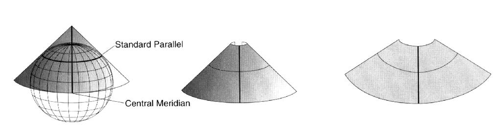
39 Conic Projections
40 Azimuthal Projections Aspect
41 Azimuthal Projections
42 Distortion in Map Projections some distortion is inevitable less distortion if maps show only small areas, but large if the entire earth is shown projections are classified according to which properties they preserve: area, shape, angles, distance
43 Conformal When the scale of a map at any point on the map is the same in any direction, the projection is conformal. Meridians (lines of longitude) and parallels (lines of latitude) intersect at right angles. Shape is preserved locally on conformal maps.
44 Equal area projections area on the map is proportional to the true area on the earth s surface required when area measures are made popular in GIS
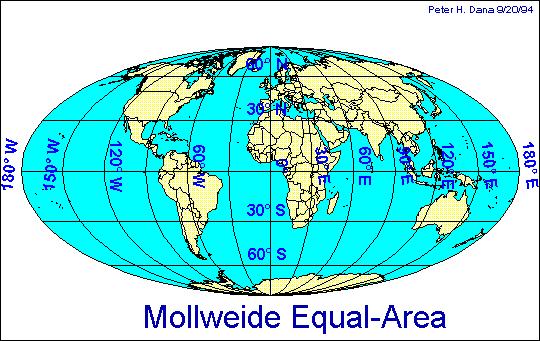
45 Equal area projections
46 Equidistant projections represent the distances to other locations from either one or two points correctly
47
48
49 UTM coordinates are usually measured in meters from the central meridian (x) and the equator (y) minimal distortions of area, angles distance and shape at large and medium scales very popular for medium scale mapping
50
51
52 GPS Coordinates Hundreds of geodetic datums are in use around the world. The Global Positioning system is based on the World Geodetic System 1984 (WGS- 84). Parameters for simple XYZ conversion between many datums and WGS-84 are published by the Defense Mapping Agency.

53
54
")
55 Lat/Long can also be represented in planar form (but is not technically a projection)
Geodesy, Geographic Datums & Coordinate Systems
 Geodesy, Geographic Datums & Coordinate Systems What is the shape of the earth? Why is it relevant for GIS? 1/23/2018 2-1 From Conceptual to Pragmatic Dividing a sphere into a stack of pancakes (latitude)
An NGS Illustrated Guide to Geodesy for GIS Professionals
 An NGS Illustrated Guide to Geodesy for GIS Professionals Michael Dennis, RLS, PE michael.dennis@noaa.gov Esri User Conference San Diego Convention Center July 14-18, 2014 San Diego, CA Why should we care
CHAPTER 2 GEODESY AND DATUMS IN NAVIGATION
 CHAPTER 2 GEODESY AND DATUMS IN NAVIGATION GEODESY, THE BASIS OF CARTOGRAPHY 200. Definition Geodesy is the application of mathematics to model the size and shape of the physical earth, enabling us to
CHAPTER 3. BASIC GEODESY
 CHAPTER 3. BASIC GEODESY SECTION I. THE GEODETIC SYSTEM A geodetic system serves as a framework for determining coordinates on the Earth s surface with respect to a reference ellipsoid and the geoid. It
PREFACE. National Geographic Department would like to express our sincere thanks for your comments.
 PREFACE According to the role of National Geographic Department on Prim Minister s Decree No 255 PM, dated August 16, 2005 regarding to Surveying, Aerial Photography and mapping activities in the territory
FieldGenius Technical Notes GPS Terminology
 FieldGenius Technical Notes GPS Terminology Almanac A set of Keplerian orbital parameters which allow the satellite positions to be predicted into the future. Ambiguity An integer value of the number of
CHAPTER 2 GEODESY AND DATUMS IN NAVIGATION
 CHAPTER 2 GEODESY AND DATUMS IN NAVIGATION GEODESY, THE BASIS OF CARTOGRAPHY 200. Definition Geodesy is the science concerned with the exact positioning of points on the surface of the earth. It also involves
ELEMENTS OF THE NATIONAL SPATIAL REFERENCE SYSTEM
 Dave Doyle NGS Chief Geodetic Surveyor dave.doyle@noaa.gov 301-713-3178 ELEMENTS OF THE NATIONAL SPATIAL REFERENCE SYSTEM ESRI SURVEY SUMMIT San Diego, CA June 17, 2007 ftp://ftp.ngs.noaa.gov/dist/daved/esri
Introduction to Datums James R. Clynch February 2006
 Introduction to Datums James R. Clynch February 2006 I. What Are Datums in Geodesy and Mapping? A datum is the traditional answer to the practical problem of making an accurate map. If you do not have
GNSS & Coordinate Systems
 GNSS & Coordinate Systems Matthew McAdam, Marcelo Santos University of New Brunswick, Department of Geodesy and Geomatics Engineering, Fredericton, NB May 29, 2012 Santos, 2004 msantos@unb.ca 1 GNSS GNSS
Map Basics: Datums and Coordinate Systems
 Map Basics: Datums and Coordinate Systems ESRM 304 Autumn 2015 Contributors: Phil Hurvitz, Peter Schiess, Eric Turnblom 1 of 39 Datums, land division systems, & coordinate systems Datums (from Wikipedia)
Standard for New Zealand Vertical Datum 2016 LINZS25009
 Standard for New Zealand Vertical Datum 2016 LINZS25009 Effective Date: 27 June 2016 Table of Contents TERMS ND DEFINITIONS... 3 FOREWORD... 5 INTRODUCTION... 5 PURPOSE OF STNDRD... 5 BRIEF HISTORY OF
Datums and Tools to Connect Geospatial Data Accurately
 Datums and Tools to Connect Geospatial Data Accurately Pamela Fromhertz Colorado State Geodetic Advisor National Geodetic Survey National Oceanic and Atmospheric Administration GIS-T April 18, 2012 Loveland,
Basic Geodetics. Bobby Saleh Guidon Energy April 13, 2017
 Experts in Geomatics, Surveying, Positioning, Geospatial Data, and Mapping Sciences Basic Geodetics Bobby Saleh Guidon Energy b.saleh@guidonenergy.com April 13, 2017 The Earth is NOT flat Q: So what does
BUILDING A SINGLE VERSION OF TRUTH
 BUILDING A SINGLE VERSION OF TRUTH Versioning in PPDM Tarun Chandrasekhar Director, Data Management Products Neuralog AGENDA Introductions Importance of Source Need for multiple sources Source Prioritization
CHAPTER 3 MARGINAL INFORMATION AND SYMBOLS
 CHAPTER 3 MARGINAL INFORMATION AND SYMBOLS A map could be compared to any piece of equipment, in that before it is placed into operation the user must read the instructions. It is important that you, as
Coordinates, Datums, and Map Projection
 Coordinates, Datums, and Map Projection Two views on the World Intersect at 90 o angles Latitude/ Longitude is a Spherical System Acceptable latitudes/longitudes i) W125 o 27 33 ii) N92 o 45 12 iii)
Lecture 16 NAD 83 (1986), NAD 83(1993) and NAD 83 (NSRS 2007) 10 March 2009 GISC3325
, NAD 83(1993) and NAD 83 (NSRS 2007) 10 March 2009 GISC3325") Lecture 16 NAD 83 (1986), NAD 83(1993) and NAD 83 (NSRS 2007) 10 March 2009 GISC3325 Significant dates 16-20 March 2009 is Spring Break 12 March 2009 is Exam Two Emphasis on chapter 5, 6 and 8 of text
Lecture 16 NAD 83 (1986), NAD 83(1993) and NAD 83 (NSRS 2007) 10 March 2009 GISC3325 Significant dates 16-20 March 2009 is Spring Break 12 March 2009 is Exam Two Emphasis on chapter 5, 6 and 8 of text
High Precision GNSS for Mapping & GIS Professionals
 High Precision GNSS for Mapping & GIS Professionals Agenda Address your needs for GNSS knowledge. GNSS Basics Satellite Ranging Fundamentals (Code $ Carrier) Differential Corrections (Post Processed $
2. CHARTS. 2.1 Chart projections Mercator projections. Maps which are used for marine or aeronautical navigation are called charts.
 Maps which are used for marine or aeronautical navigation are called charts. In Canadian waters, mariners are required to carry the latest editions of the paper charts, at the largest scale available (see
WISCONSIN COORDINATE SYSTEMS
 Pdf versions of the Handout and Powerpoint slides are on jerrymahun.com. Follow the USPLSS Forum link and use the password: WildT2 WISCONSIN COORDINATE SYSTEMS CONCEPTS & IMPLEMENTATION Jerry Mahun, PLS,
Errors in GPS. Errors in GPS. Geodetic Co-ordinate system. R. Khosla Fall Semester
 Errors in GPS Errors in GPS GPS is currently the most accurate positioning system available globally. Although we are talking about extreme precision and measuring distances by speed of light, yet there
Standard for the Australian Survey Control Network
 Standard for the Australian Survey Control Network Special Publication 1 Intergovernmental Committee on Survey and Mapping (ICSM) Geodesy Technical Sub-Committee (GTSC) 30 March 2012 Table of contents
Geodetic Positioning Refresher
 Geodetic Positioning Refresher by Joan Yau PhD ABCLS AGM 2016, Kimberley BC Contents Horizontal / Vertical Datums and Epochs used in BC and Canada How do we reference our project coordinates to BC datums
SOME OBSERVATIONS ON THE USE OF GPS AND CHARTS
 International Hydrographic Review, Monaco, LXX(2), September 1993 SOME OBSERVATIONS ON THE USE OF GPS AND CHARTS by D. SIMPSON 1 INTRODUCTION The purpose of this paper is to bring to the attention of chart
GPS. Essentials of Satellite Navigation. Compendium. locate, communicate, accelerate. Abstract
 GPS Essentials of Satellite Navigation Compendium locate, communicate, accelerate Abstract Theory and Principles of Satellite Navigation. Overview of GPS/GNSS Systems and Applications. www.u-blox.com Document
Math 215 Project 1 (25 pts) : Using Linear Algebra to solve GPS problem
 : Using Linear Algebra to solve GPS problem") Due 11:55pm Fri. Sept. 28 NAME(S): Math 215 Project 1 (25 pts) : Using Linear Algebra to solve GPS problem 1 Introduction The age old question, Where in the world am I? can easily be solved nowadays by
Due 11:55pm Fri. Sept. 28 NAME(S): Math 215 Project 1 (25 pts) : Using Linear Algebra to solve GPS problem 1 Introduction The age old question, Where in the world am I? can easily be solved nowadays by
Overview of New Datums NOAA s National Geodetic Survey
 Overview of New Datums NOAA s National Geodetic Survey February 3, 2015 1 NGS s Mission and Role NGS Mission: To define, maintain, and provide access to the National Spatial Reference System to meet our
CH 21 2-SPACE. Ch 21 2-Space. y-axis (vertical) x-axis. Introduction
 x-axis. Introduction") 197 CH 21 2-SPACE Introduction S omeone once said A picture is worth a thousand words. This is especially true in math, where many ideas are very abstract. The French mathematician-philosopher René Descartes
197 CH 21 2-SPACE Introduction S omeone once said A picture is worth a thousand words. This is especially true in math, where many ideas are very abstract. The French mathematician-philosopher René Descartes
DOUBLE PROPORTION MADE COMPLEX
 DOUBLE PROPORTION MADE COMPLEX Jerry L. Wahl Branch of Cadastral Surveys Bureau of Land Management California State Office 2800 Cottage Way, E-2841 Sacramento, California 95825 ABSTRACT Our ever increasing
CHAPTER 3 NAUTICAL CHARTS
 CHAPTER 3 NAUTICAL CHARTS CHART FUNDAMENTALS 300. Definitions A nautical chart represents part of the spherical earth on a plane surface. It shows water depth, the shoreline of adjacent land, topographic
Important Questions. Surveying Unit-II. Surveying & Leveling. Syllabus
 Surveying Unit-II Important Questions Define Surveying and Leveling Differentiate between Surveying and Leveling. Explain fundamental Principles of Surveying. Explain Plain and Diagonal Scale. What is
TDS Survey Pro CE Version Setup RTK Base on known NAD83/WGS84 Point: Mapping Plane Geoid99 Modeling.
 TDS Survey Pro CE Version 2.1.8 Setup RTK Base on known NAD83/WGS84 Point: Mapping Plane Geoid99 Modeling. Pre-load known NAD83 State Plane Coordinates and appropriate NGS Geoid 99/96 data files into the
CHAPTER 3 NAUTICAL CHARTS
 CHAPTER 3 NAUTICAL CHARTS CHART FUNDAMENTALS 300. Definitions A nautical chart represents part of the spherical earth on a plane surface. It shows water depth, the shoreline of adjacent land, prominent
GEODESY LESSON PLAN Meet Geodesy
 Meet Lesson Plan GEODESY LESSON PLAN Meet Focus Introduction to geodesy Grade Level 9-12 Focus Question What is geodesy, and why is it important? Learning Objectives Students will be able to define geodesy.
GNSS 101 Bringing It Down To Earth
 GNSS 101 Bringing It Down To Earth Steve Richter Frontier Precision, Inc. UTM County Coordinates NGVD 29 State Plane Datums Scale Factors Projections Session Agenda GNSS History & Basic Theory Coordinate
Overview of New Datums
 Overview of New Datums Scott Lokken NC Advisor NOAA s National Geodetic Survey 9/4/2015 1 New Datums are Coming in 2022! Both a new geometric and a new geopotential (vertical) datum will be released in
RECOMMENDATION ITU-R S.1257
 Rec. ITU-R S.157 1 RECOMMENDATION ITU-R S.157 ANALYTICAL METHOD TO CALCULATE VISIBILITY STATISTICS FOR NON-GEOSTATIONARY SATELLITE ORBIT SATELLITES AS SEEN FROM A POINT ON THE EARTH S SURFACE (Questions
Lab #4 Topographic Maps and Aerial Photographs
 Lab #4 Topographic Maps and Aerial Photographs Purpose To familiarize you with using topographic maps. Visualizing the shape of landforms from topographic maps is an essential skill in geology. Proficiency
Definition and use of the New Zealand Vertical Datum Matt Amos Senior Advisor Geodesy
 Definition and use of the New Zealand Vertical Datum 2009 Matt Amos Senior Advisor Geodesy NZIS Continuing Professional Development Programme, November 2009 Overview Height Theory Heights in New Zealand
What makes the positioning infrastructure work. Simon Kwok Chairman, Land Surveying Division Hong Kong Institute of Surveyors
 What makes the positioning infrastructure work The experience of the Hong Kong Satellite Positioning Reference Station Network Simon Kwok Chairman, Land Surveying Division Hong Kong Institute of Surveyors
Graphic Communications
 Graphic Communications Lecture 8: Projections Assoc. Prof.Dr. Cengizhan İpbüker İTÜ-SUNY 2004-2005 2005 Fall ipbuker_graph06 Projections The projections used to display 3D objects in 2D are called Planar
A NEW GEOCENTRIC DATUM FOR NEW ZEALAND
 A NEW GEOCENTRIC DATUM FOR NEW ZEALAND Don Grant Graeme Blick Office of Surveyor-General Land Information New Zealand PO Box 5501 Wellington New Zealand Phone 04 4600100 Fax 04 4722244 dgrant@linz.govt.nz
Using GPS to Establish the NAVD88 Elevation on Reilly The A-order HARN Station at NMSU
 Using GPS to Establish the NAVD88 Elevation on Reilly The A-order HARN Station at NMSU Earl F. Burkholder, PS, PE New Mexico State University Las Cruces, NM 88003 July 005 Introduction GPS has become an
Datum Transformations: Nightmare on GIS Street. Agenda
 Datum Transformations: Nightmare on GIS Street Speaker: Eric Gakstatter Contributing Editor GPS World Editor - Geospatial Solutions Presented at: Minnesota Society of Professional Surveyors Bloomington,
DATUM TRANSFORMATION BETWEEN NATIONAL GEODETIC DATUM AND ITRF
 DATUM TRANSFORMATION BETWEEN NATIONAL GEODETIC DATUM AND ITRF M.Sc. Zlatko Bogdanovsk i FCE Skopje Chair for High Geodesy INTRODUCTION COORDINATE TRANSFORMATION Need of establishing dependence between
GPS for. Land Surveyors. Jan Van Sickle. Fourth Edition. CRC Press. Taylor & Francis Group. Taylor & Francis Croup, an Informa business
 GPS for Land Surveyors Fourth Edition Jan Van Sickle CRC Press Taylor & Francis Group Boca Raton London New York CRC Press is an imprint of the Taylor & Francis Croup, an Informa business Contents Preface
Land Navigation / Map Reading
 Land Navigation / Map Reading What is the Field Manual for map reading and land navigation? FM 3-25.26 What are the basic colors of a map, and what does each color represent? Black - Indicates cultural
Salient Feature of ITRF. Realization of Dubai Emirate Datum. Reference Frame 2000 (Ditr 2000)
") Salient Feature of ITRF on the Reference Frame 2000 (Ditr 2000) ITRF stands for International Terrestrial Reference Frame ITRF established by the International Earth Rotation Service (IERS), France. One
Salient Feature of ITRF on the Reference Frame 2000 (Ditr 2000) ITRF stands for International Terrestrial Reference Frame ITRF established by the International Earth Rotation Service (IERS), France. One
Determining Accurate Elevations: Datums & Tools, Today & Tomorrow
 Determining Accurate Elevations: Datums & Tools, Today & Tomorrow Association of State Floodplain Managers Annual Meeting Grand Rapids, MI Christine Gallagher June 21, 2016 Overview NGS Mission Important
Datums for a Dynamic Earth
 Datums for a Dynamic Earth Based on a paper given at the American Society of Agricultural and Biological Engineers (ASABE) Conference in Reno, Nevada June 2009 Rollin StrohmanPh.D. Tom Mastin L.S Background
ENVI.2030L Topographic Maps and Profiles
 Name ENVI.2030L Topographic Maps and Profiles I. Introduction A map is a miniature representation of a portion of the earth's surface as it appears from above. The environmental scientist uses maps as
Chapter 6 GPS Relative Positioning Determination Concepts
 Chapter 6 GPS Relative Positioning Determination Concepts 6-1. General Absolute positioning, as discussed earlier, will not provide the accuracies needed for most USACE control projects due to existing
BASELINE SURVEY, VISUAL - STANDARD
 BASELINE SURVEY, VISUAL - STANDARD Introduction As stated in SEPA s policy and in the Fish Farm Manual (1998), scientific data are required by SEPA in order to assess the existing condition on the site
GLOBAL POSITIONING SYSTEMS
 GLOBAL POSITIONING SYSTEMS GPS & GIS Fall 2017 Global Positioning Systems GPS is a general term for the navigation system consisting of 24-32 satellites orbiting the Earth, broadcasting data that allows
Appendix. Springer International Publishing Switzerland 2016 A.Y. Brailov, Engineering Graphics, DOI /
 Appendix See Figs. A.1, A.2, A.3, A.4, A.5, A.6, A.7, A.8, A.9, A.10, A.11, A.12, A.13, A.14, A.15, A.16, A.17, A.18, A.19, A.20, A.21, A.22, A.23, A.24, A.25, A.26, A.27, A.28, A.29, A.30, A.31, A.32,
Progress Towards the Seamless Combination of Bathymetric and Topographic Data in New Zealand
 Progress Towards the Seamless Combination of Bathymetric and Topographic Data in New Zealand Matt Amos Senior Technical Advisor National Geodetic Office Introduction Datasets usually defined in terms of
Field DGPS Report AT
 Field DGPS Report AT-329 2005 Ellen M. Sundlisæter Lene Kristensen Sigrid K. Dahl Ulli Neumann 1 Table of contents Table of contents...2 Introduction...2 Methods...3 Equipment...3 Availability...3 Setup...3
NGA s Support for Positioning and Navigation
 NGA s Support for Positioning and Navigation PNT Symposium 6 November 2007 Barbara Wiley NATIONAL GEOSPATIAL-INTELLIGENCE AGENCY What is NGA and What Do We Do? National Geospatial-Intelligence Agency (NGA)
Understanding the Evolution of WGS 84 and NAD 83
 Summary Both WGS 84, the datum used by GPS,, commonly used in North America, have been redefined several times since their beginning. Parallel to this, there have also been several realizations of the
Appendix A Lower Columbia River Chart Datum Modeling
 Appendix A Lower Columbia River Chart Datum Modeling David Evans and Associates, Inc. David Evans and Associates, Inc. 2801 SE Columbia Way, Ste. 130 Vancouver, WA 98661 (360) 314-3200 1.0 Vertical Datum
t =1 Transmitter #2 Figure 1-1 One Way Ranging Schematic
 1.0 Introduction OpenSource GPS is open source software that runs a GPS receiver based on the Zarlink GP2015 / GP2021 front end and digital processing chipset. It is a fully functional GPS receiver which
Lecture 3: Geometrical Optics 1. Spherical Waves. From Waves to Rays. Lenses. Chromatic Aberrations. Mirrors. Outline
 Lecture 3: Geometrical Optics 1 Outline 1 Spherical Waves 2 From Waves to Rays 3 Lenses 4 Chromatic Aberrations 5 Mirrors Christoph U. Keller, Leiden Observatory, keller@strw.leidenuniv.nl Lecture 3: Geometrical
GNSS: orbits, signals, and methods
 Part I GNSS: orbits, signals, and methods 1 GNSS ground and space segments Global Navigation Satellite Systems (GNSS) at the time of writing comprise four systems, two of which are fully operational and
Suveying Lectures for CE 498
 Suveying Lectures for CE 498 SURVEYING CLASSIFICATIONS Surveying work can be classified as follows: 1- Preliminary Surveying In this surveying the detailed data are collected by determining its locations
NATIONAL VDATUM -- THE IMPLEMENTATION OF A NATIONAL VERTICAL DATUM TRANSFORMATION DATABASE
 NATIONAL VDATUM -- THE IMPLEMENTATION OF A NATIONAL VERTICAL DATUM TRANSFORMATION DATABASE Bruce Parker, Dennis Milbert, Kurt Hess, and Stephen Gill National Ocean Service, NOAA The National Ocean Service
Utilizing A GNSS Network Solution for Utility Applications
 Utilizing A GNSS Network Solution for Utility Applications David Newcomer, PE, PLS GPServ, Inc. newcomer@ (407) 601-5816 AGENDA Types and accuracies of data collection o Autonomous o Meter + o Sub-meter
(Pseudo-range error) Phase-delay)
 Phase-delay)") GPS (NMEA) NMEA-0183 (GIS) (ϕ,, h) (x, y, z) LabVIEW Matlab GPS (Pseudo-range error) (Carrier Phase-delay) (NMEA) (GPS) (GIS) (WGS ) (TWD) Design of a Real-time and On-line Prototype Software in GPS/GIS
GPS (NMEA) NMEA-0183 (GIS) (ϕ,, h) (x, y, z) LabVIEW Matlab GPS (Pseudo-range error) (Carrier Phase-delay) (NMEA) (GPS) (GIS) (WGS ) (TWD) Design of a Real-time and On-line Prototype Software in GPS/GIS
GPS Technical Overview N5TWP NOV08. How Can GPS Mislead
 GPS Technical Overview How Can GPS Mislead 1 Objectives Components of GPS Satellite Acquisition Process Position Determination How can GPS Mislead 2 Components of GPS Control Segment Series of monitoring
Geodetic policy for Ireland and Northern Ireland
 Geodetic policy for Ireland and Northern Ireland Background Ordnance Survey Ireland (OSi) is the National Mapping Agency (NMA) of the Republic of Ireland. The Ordnance Survey of Northern Ireland (OSNI)
CGG. Office of the Surveyor General of the Federation Federal Capital Territory, Abuja, Nigeria 2
 Prof. P. C. Nwilo 1, * Dr. J. D. Dodo 2, U. R. Edozie 1, and A. Adebomehin 1. 1 Office of the Surveyor General of the Federation Federal Capital Territory, Abuja, Nigeria 2 Centre for Geodesy and Geodynamics,
Copyrighted Material. Copyrighted Material. Copyrighted. Copyrighted. Material
 Engineering Graphics ORTHOGRAPHIC PROJECTION People who work with drawings develop the ability to look at lines on paper or on a computer screen and "see" the shapes of the objects the lines represent.
BATHYMETRIC DATA AND NAUTICAL CHART DATUMS
 Distr. LIMITED ECA/NRD/CART.9/USA.2 October 1996 Original: ENGLISH Ninth United Nations Regional Cartographic Conference for Africa Addis Ababa, Ethiopia 11-15 November 1996 A GLOBAL APPROACH TO UPDATE
OPTIMUM GEODETIC DATUM TRANSFORMATION TECHNIQUES FOR GPS SURVEYS IN EGYPT
 Proceedings of Al-Azhar Engineering Sixth International Conference, Sept. 1-, 2000, Cairo, Egypt, Volume, pp. 09-1. OPTIMUM GEODETIC DATUM TRANSFORMATION TECHNIQUES FOR GPS SURVEYS IN EGYPT By Dr. Gomaa
Distribution Restriction Statement Approved for public release; distribution is unlimited.
 CECW-EP Engineer Manual 1110-1-1005 Department of the Army U.S. Army Corps of Engineers Washington, DC 20314-1000 Engineering and Design TOPOGRAPHIC SURVEYING Distribution Restriction Statement Approved
MONITORING SEA LEVEL USING GPS
 38 MONITORING SEA LEVEL USING GPS Hasanuddin Z. Abidin* Abstract GPS (Global Positioning System) is a passive, all-weather satellite-based navigation and positioning system, which is designed to provide
Lecture 4 : Monday April 6th
 Lecture 4 : Monday April 6th jacques@ucsd.edu Key concepts : Tangent hyperplane, Gradient, Directional derivative, Level curve Know how to find equation of tangent hyperplane, gradient, directional derivatives,
Determining Accurate Elevations: Datums & Tools, Today & Tomorrow
 Determining Accurate Elevations: Datums & Tools, Today & Tomorrow Maryland Association Floodplain and Stormwater Managers Linthicum Heights, MD Christine Gallagher Oct. 20, 2016 Overview NGS Mission Important
INTRODUCTION TO ENGINEERING SURVEYING (CE 1305)
") INTRODUCTION TO ENGINEERING SURVEYING (CE 1305) Coordinate Systems Sr Dr. Tan Liat Choon Email: tanliatchoon@gmail.com Mobile: 016-4975551 1 NATIONAL COORDINATE REFERENCE SYSTEM There are 2 types of coordinate
INTRODUCTION TO ENGINEERING SURVEYING (CE 1305) Coordinate Systems Sr Dr. Tan Liat Choon Email: tanliatchoon@gmail.com Mobile: 016-4975551 1 NATIONAL COORDINATE REFERENCE SYSTEM There are 2 types of coordinate
HYDROGRAPHIC SURVEY STANDARDS AND DELIVERABLES
 TABLE OF CONTENTS 1. HYDROGRAPHIC SURVEY METHODOLOGY... 3 2. HYDROGRAPHIC SURVEY REFERENCE STANDARDS... 3 3. HYDROGRAPHIC SURVEY CRITERIA... 3 3.1 HYDROGRAPHIC SURVEYS OVER NON GAZETTED NAVIGABLE WATERS*:...
NJDEP GPS Data Collection Standards for GIS Data Development
 NJDEP GPS Data Collection Standards for GIS Data Development Bureau of Geographic Information Systems Office of Information Resource Management April 24 th, 2017 Table of Contents 1.0 Introduction... 3
BILL HENNING, Prof LS. ACRONYMS
 BILL HENNING, Prof LS. ACRONYMS US 1 WIKIPEDIA: Also known as geodetics, geodetic engineering or geodetics engineering a branch of applied mathematics [2] and earth sciences, is the scientific discipline
Lesson 10. Unit 2. Reading Maps. Graphing Points on the Coordinate Plane
 Lesson Graphing Points on the Coordinate Plane Reading Maps In the middle ages a system was developed to find the location of specific places on the Earth s surface. The system is a grid that covers the
GPS for Snowmobilers. By Wayne Fischer. November 14, 2006
 GPS for Snowmobilers By Wayne Fischer November 14, 2006 Wayne@TahoeSnowmobiling.org Copy of White Paper & Presentation Both this presentation and the white paper are available on the www.tahoesnowmobiling.org
Choosing the best path:
 GEODESY Choosing the best path: Global to national coordinate transformations The paper demonstrates that differences of up to a few centimetres in each coordinate component can occur depending on the
SURVEYING I CENG 383
 SURVEYING I CENG 383 9/21/2011 2 Introduction Definition An art of collecting data for mapping the relative positions of points above, below or on the surface of the earth. Surveying also includes the
What makes a co-ordinate unique?
 What makes a co-ordinate unique? Richard Wylde FRICS Geodesist, ExxonMobil Slide No. 2 Co-ordinates easily allow us to express positions uniquely? Position the Rig at: 6319306.082 N 378508.277 E - UTM
Hyperbolas Graphs, Equations, and Key Characteristics of Hyperbolas Forms of Hyperbolas p. 583
 C H A P T ER Hyperbolas Flashlights concentrate beams of light by bouncing the rays from a light source off a reflector. The cross-section of a reflector can be described as hyperbola with the light source
LEVELING. Definitions
 Definitions An elevation of a point : The vertical distance between the point and the reference level surface ( datum ),the most commonly used datum is the mean sea level (MSL ). Leveling : The process
GPS Basics. Introduction to GPS (Global Positioning System) Version 1.0 English
 Version 1.0 English") 20 30 40 50 GPS Basics Introduction to GPS (Global Positioning System) Version 1.0 English Contents Preface... 4 1. What is GPS and what does it do?... 5 2. System Overview... 6 2.1 The Space Segment...
20 30 40 50 GPS Basics Introduction to GPS (Global Positioning System) Version 1.0 English Contents Preface... 4 1. What is GPS and what does it do?... 5 2. System Overview... 6 2.1 The Space Segment...
Beginners Guide to GPS Elevation Plus an Update on GPS Technology
 Beginners Guide to GPS Elevation Plus an Update on GPS Technology A TMS Presentation By: Jon Aschenbach Summerlake Enterprises 919 36 th Place Forest Grove, OR 97116 503-707-6236 Coeur d Alene, ID April,
GPS 101. An Introduction to Using a GPS Receiver
 GPS 101 An Introduction to Using a GPS Receiver The goal of this presentation if to provide a basic understanding of what is GPS, how it works, provide some basic terminology and to provide ideas on how
Basics of Satellite Navigation an Elementary Introduction Prof. Dr. Bernhard Hofmann-Wellenhof Graz, University of Technology, Austria
 Basics of Satellite Navigation an Elementary Introduction Prof. Dr. Bernhard Hofmann-Wellenhof Graz, University of Technology, Austria Basic principles 1.1 Definitions Satellite geodesy (SG) comprises
8/17/2014. Process of directly or indirectly measuring vertical distances to determine the elevation of points or their differences in elevation
 Process of directly or indirectly measuring vertical distances to determine the elevation of points or their differences in elevation Leveling results are used: To design highways, railroads, canals, sewers,
The Global Positioning System II Field Experiments
 The Global Positioning System II Field Experiments 5-1 Mexico DGPS Field Campaign Cenotes in Tamaulipas, MX, near Aldama 5-2 Are Cenote Water Levels Related? 5-3 DGPS Static Survey of Cenote Water Levels
PROJECTIONS PARALLEL CONICAL PROJECTIONS PROJECTIONS OBLIQUE ORTHOGRAPHIC PROJECTIONS PROJECTIONS
 PROJECTIONS CONICAL PROJECTIONS PARALLEL PROJECTIONS OBLIQUE PROJECTIONS ORTHOGRAPHIC PROJECTIONS ISOMETRIC MULTI-VIEW an object; The Description of Forms Behind every drawing of an object is space relationship
NAVSTAR Global Positioning System Surveying
 1 August 1996 US Army Corps of Engineers ENGINEERING AND DESIGN NAVSTAR Global Positioning System Surveying ENGINEER MANUAL 1 DEPARTMENT OF THE ARMY EM 1110-1-1003 U.S. Army Corps of Engineers CECW-EP
Lecture 2: Geometrical Optics. Geometrical Approximation. Lenses. Mirrors. Optical Systems. Images and Pupils. Aberrations.
 Lecture 2: Geometrical Optics Outline 1 Geometrical Approximation 2 Lenses 3 Mirrors 4 Optical Systems 5 Images and Pupils 6 Aberrations Christoph U. Keller, Leiden Observatory, keller@strw.leidenuniv.nl
APPENDIX GPS TERMINOLOGY
 APPENDIX GPS TERMINOLOGY Almanac Data transmitted by a GPS satellite which includes orbital information on all the satellites, clock correction, and atmospheric delay parameters. These data are used to