GLOBAL POSITIONING SYSTEMS
|
|
|
- Kory Beasley
- 6 years ago
- Views:
Transcription
1 GLOBAL POSITIONING SYSTEMS GPS & GIS Fall 2017
2 Global Positioning Systems GPS is a general term for the navigation system consisting of satellites orbiting the Earth, broadcasting data that allows users on Earth to determine their spatial position GNSS, Global Navigation Satellite Systems, is another more general, recent acronym for these types of systems
3 NAVigation System with Time and Ranging NAVSTAR is the GPS satellite constellation created, launched, and operated by the US Government
4 NAVigation System with Time and Ranging 1978: First satellite is launched 1995: Department of Defense (DoD) claimed NAVSTAR to be fully functional for civilians 2002: DoD removed Selective Availability, which deliberately corrupted GPS signals to create a random error anywhere up to 100m
5 GLObal NAvigation Satellite System GLONASS is the GPS satellite constellation created and operated by the Russian Government
6 GLObal NAvigation Satellite System 1982: First satellite launched 1995: Fully operational Late 1990 s 2001: System decline, many repairs are needed 2011: Full global coverage is restored all 24 satellites are operational after Russia invested in an overhaul of the system
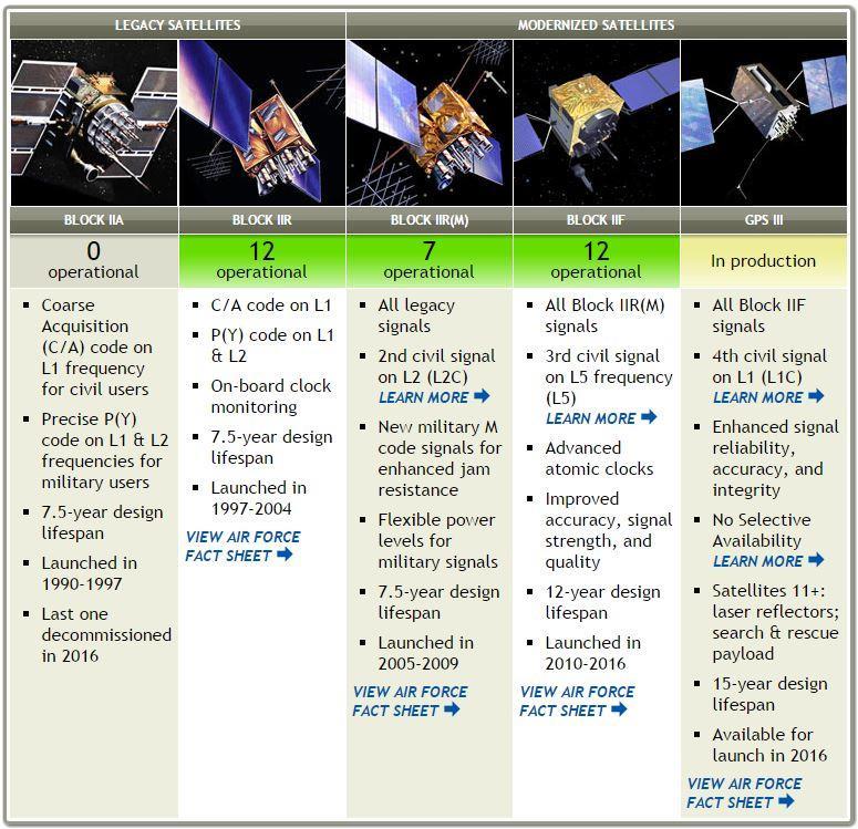
7 Other GPS systems Galileo, developed by European nations First satellite was launched in 2011 Will consist of 24 operational satellites Initial services will be available by end of 2016 Fully up & operational by 2020 BeiDou, developed by China In 2012, 16 satellites were operational providing coverage to most of Asia By 2020, all 35 satellites should be operational and coverage will be global
8
9 Where are you? Humans use the sun to keep track of time, but how we do we keep track of space? Making observations of what is around us Organize space by the features in that space we can find a feature based on our knowledge of other features
10 Where are you? Relative location. VS Portland is located about 175 miles south of Seattle, 650 miles north of San Francisco, and 75 miles from the Pacific Ocean Absolute location N, W
11 Where are you? Maps were created to pass around spatial information they use both relative & absolute location
12 Where are you? GPS allows us to find a position on Earth using satellites in space Concept is not too different from using the stars to determine location on Earth GPS is a method that easily allows us to know absolute locations on Earth
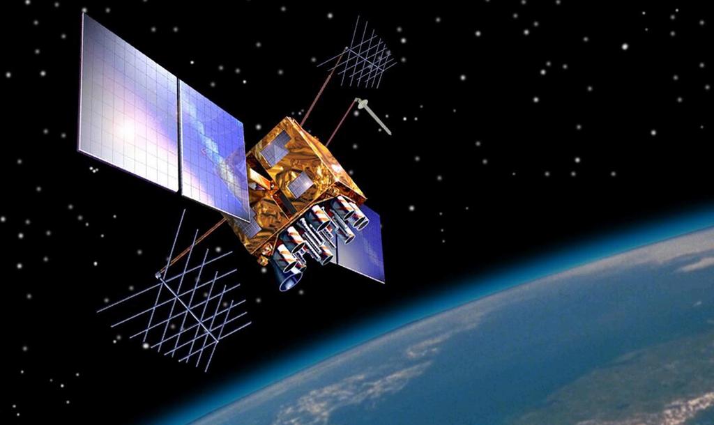
13 GPS Components Many components are in place atomic clock, satellites, receivers
14 Atomic clocks GPS is based on a system that uses time to determine location how long does it take for a signal to reach a receiver from a satellite? Atomic clocks are responsible for synchronizing time across most of our technology Each GPS satellite has multiple atomic clocks that contribute to precise time data They can determine time with 100 billionths of a second!
15
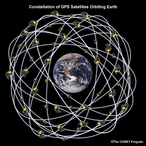
16 Space Satellites Fly about 12,550 miles above the earth Each satellite circles the Earth 2x day Arranged in 6 equally spaced orbital planes around the Earth, with 4 satellites on each orbit As of June 2016, there were 31 operational satellites in NAVSTAR, along with a couple of decommissioned ones that stay in orbit
17
18 Control Satellites Global network of ground stations Tracks space satellites, Monitors transmissions from space satellites, Performs analyses on data, Sends commands & data back

19 Control Satellites
20 Control Satellites Monitor Stations Track space satellites and channel observations back to the master control system Collect atmospheric data, range/carrier measurements, and navigational signals Ground Antennas Communicate with space satellites for command & control Send/transmit data uploads, collects telemetry


21 Receivers
22 Receivers Converts satellite signals into position, velocity, and time estimates Includes an antenna & processor Accuracy depends largely on the receiver 10-30m accuracy out of the box for most recreational units 5-10m accuracy for most commercial units Post-processing can get improve accuracy

23 Users
24 Users
25 Users Plan for data collection & analysis Must have an understanding of the technology Use GPS & GIS technology to: Plan GPS survey Collect data Download data & base station data Correct positions Export data to GIS
26 So, how does GPS work?
27 It provides location, right? WGS 1984 v. NAD 83 v. NAD 27 Datum Longitude Latitude NAD NAD WGS
28 Datums & GPS NAVSTAR is based on WGS84, but most GPS units can calculate & display coordinates in other datums For reference: State of Oregon GIS Data uses Oregon Lambert projection, based on NAD83 (international ft) RLIS uses HARN StatePlane Oregon North projection, based on NAD83
29 How does it determine position? Distances to several satellites are calculated from measurements of the time it takes for radio waves to reach from the satellites (whose positions are known precisely), to the receiver Distance = velocity * time

30 How does it determine position? Distance from one satellite tells us we are located somewhere on the surface of an imaginary sphere centered on that satellite with a radius of x
31 How does it determine position? Distance measurements from 2 satellites limits our location to the intersection of 2 spheres, which is a circle
32 How does it determine position? A 3 rd measurement narrows our location to just 2 points on the Earth s surface
33 How does it determine position? A 4 th measurement determines which point is the true location 4 th satellites sets the receiver s clock, providing more precision (x,y,z,t) Process is called TRIANGULATION
34 Receiving signals Most GPS receivers need a minimum of 4 satellites in view to start collecting data Low-end receivers have only one channel for receiving signals from satellites High-end receivers can have up to 76 channels!
35 Not all signals are created equal Civilian & Military signals are not equal Course acquisition code (c) v. Precision code (m)
36 Signals Pseudo random code Coarse Acquisition Freely available to the public Transmitted on L1, L2C, L5C & L1C Precision code Designated for military use Encrypted to prevent unauthorized use Transmitted on the L2 frequency

37 Signals Coarse acquisition Precise code Note frequency differences

38 Pseudo-random code Each satellite sends a unique code, which is extremely complex (hence, almost random) so that patterns are not linked up at the wrong place on the code Sent by satellite at time x Received by satellite at time y
39 Pseudo-random code The code has to be generated from each source at exactly the same time So, the satellites have atomic clocks that keep nearly perfect time but not so on the GPS receiver
Principal Investigator Co-Principal Investigator Co-Principal Investigator Prof. Talat Ahmad Vice-Chancellor Jamia Millia Islamia Delhi
 Subject Paper No and Title Module No and Title Module Tag Geology Remote Sensing and GIS Concepts of Global Navigation Satellite RS & GIS XXXIII Principal Investigator Co-Principal Investigator Co-Principal
What is a GPS How does GPS work? GPS Segments GPS P osition Position Position Accuracy Accuracy Accuracy GPS A pplications Applications Applications
 What is GPS? What is a GPS How does GPS work? GPS Segments GPS Position Accuracy GPS Applications What is GPS? The Global Positioning System (GPS) is a precise worldwide radio-navigation system, and consists
King AbdulAziz University. Faculty of Environmental Design. Geomatics Department. Mobile GIS GEOM 427. Lecture 3
 King AbdulAziz University Faculty of Environmental Design Geomatics Department Mobile GIS GEOM 427 Lecture 3 Ahmed Baik, Ph.D. Email: abaik@kau.edu.sa Eng. Fisal Basheeh Email: fbasaheeh@kau.edu.sa GNSS
GLOBAL NAVIGATION SATELLITE SYSTEMS (GNSS) ECE 2526E Tuesday, 24 April 2018
 ECE 2526E Tuesday, 24 April 2018") GLOBAL NAVIGATION SATELLITE SYSTEMS (GNSS) ECE 2526E Tuesday, 24 April 2018 MAJOR GLOBAL NAVIGATION SATELLITE SYSTEMS (GNSS) Global Navigation Satellite System (GNSS) includes: 1. Global Position System
GLOBAL NAVIGATION SATELLITE SYSTEMS (GNSS) ECE 2526E Tuesday, 24 April 2018 MAJOR GLOBAL NAVIGATION SATELLITE SYSTEMS (GNSS) Global Navigation Satellite System (GNSS) includes: 1. Global Position System
GLOBAL POSITIONING SYSTEMS. Knowing where and when
 GLOBAL POSITIONING SYSTEMS Knowing where and when Overview Continuous position fixes Worldwide coverage Latitude/Longitude/Height Centimeter accuracy Accurate time Feasibility studies begun in 1960 s.
Entity Tracking and Surveillance using the Modified Biometric System, GPS-3
 Advance in Electronic and Electric Engineering. ISSN 2231-1297, Volume 3, Number 9 (2013), pp. 1115-1120 Research India Publications http://www.ripublication.com/aeee.htm Entity Tracking and Surveillance
GNSS 101 Bringing It Down To Earth
 GNSS 101 Bringing It Down To Earth Steve Richter Frontier Precision, Inc. UTM County Coordinates NGVD 29 State Plane Datums Scale Factors Projections Session Agenda GNSS History & Basic Theory Coordinate
Challenges and Solutions for GPS Receiver Test
 Challenges and Solutions for GPS Receiver Test Presenter: Mirin Lew January 28, 2010 Agenda GPS technology concepts GPS and GNSS overview Assisted GPS (A-GPS) Basic tests required for GPS receiver verification
GLOBAL POSITIONING SYSTEMS
 GLOBAL POSITIONING SYSTEMS Maps & Geospatial Concepts Fall 2015 Before GPS Historical look at navigation Giant concrete arrows that point your way across America What are these giant arrows? Some kind
NR402 GIS Applications in Natural Resources
 NR402 GIS Applications in Natural Resources Lesson 5 GPS/GIS integration Global Positioning System (GPS)..a global navigation system that everyone can use What is GPS? How does it work? How accurate is
Global Positioning Systems (GPS) Trails: the achilles heel of mapping from the air / satellites
 Trails: the achilles heel of mapping from the air / satellites") Global Positioning Systems (GPS) Trails: the achilles heel of mapping from the air / satellites Google maps updated regularly by local users using GPS Also: http://openstreetmaps.org GPS applications
Global Positioning Systems (GPS) Trails: the achilles heel of mapping from the air / satellites Google maps updated regularly by local users using GPS Also: http://openstreetmaps.org GPS applications
Introduction to Geographic Information Science. Last Lecture. Today s Outline. Geography 4103 / GNSS/GPS Technology
 Geography 4103 / 5103 Introduction to Geographic Information Science GNSS/GPS Technology Last Lecture Geoids Ellipsoid Datum Projection Basics Today s Outline GNSS technology How satellite based navigation
GPS: The Basics. Darrell R. Dean, Jr. Civil and Environmental Engineering West Virginia University. Expected Learning Outcomes for GPS
 GPS: The Basics Darrell R. Dean, Jr. Civil and Environmental Engineering West Virginia University Expected Learning Outcomes for GPS Explain the acronym GPS Name 3 important tdt dates in history of GPS
GPS and Recent Alternatives for Localisation. Dr. Thierry Peynot Australian Centre for Field Robotics The University of Sydney
 GPS and Recent Alternatives for Localisation Dr. Thierry Peynot Australian Centre for Field Robotics The University of Sydney Global Positioning System (GPS) All-weather and continuous signal system designed
GPS Global Positioning System
 GPS Global Positioning System 10.04.2012 1 Agenda What is GPS? Basic consept History GPS receivers How they work Comunication Message format Satellite frequencies Sources of GPS signal errors 10.04.2012
The topic we are going to see in this unit, the global positioning system, is not directly related with the computer networks we use everyday, but it
 The topic we are going to see in this unit, the global positioning system, is not directly related with the computer networks we use everyday, but it is indeed a kind of computer network, as the specialised
Global Positioning Systems - GPS
 Global Positioning Systems - GPS GPS Why? What is it? How does it work? Differential GPS How can it help me? GPS Why?? Where am I? How do I get there? Where are you, and how do I get to You? WHO CARES???
GPS Tutorial Trimble Home > GPS Tutorial > How GPS works? > Triangulating
 http://www.trimble.com/gps/howgps-triangulating.shtml Page 1 of 3 Trimble Worldwide Popula PRODUCTS & SOLUTIONS SUPPORT & TRAINING ABOUT TRIMBLE INVESTORS GPS Tutorial Trimble Home > GPS Tutorial > How
Lecture-1 CHAPTER 2 INTRODUCTION TO GPS
 Lecture-1 CHAPTER 2 INTRODUCTION TO GPS 2.1 History of GPS GPS is a global navigation satellite system (GNSS). It is the commonly used acronym of NAVSTAR (NAVigation System with Time And Ranging) GPS (Global
Introduction to Total Station and GPS
 Introduction to Total Station and GPS Dr. P. NANJUNDASWAMY Professor of Civil Engineering J S S Science and Technology University S J College of Engineering Mysuru 570 006 Introduction History GPS Overview
t =1 Transmitter #2 Figure 1-1 One Way Ranging Schematic
 1.0 Introduction OpenSource GPS is open source software that runs a GPS receiver based on the Zarlink GP2015 / GP2021 front end and digital processing chipset. It is a fully functional GPS receiver which
PRINCIPLES AND FUNCTIONING OF GPS/ DGPS /ETS ER A. K. ATABUDHI, ORSAC
 PRINCIPLES AND FUNCTIONING OF GPS/ DGPS /ETS ER A. K. ATABUDHI, ORSAC GPS GPS, which stands for Global Positioning System, is the only system today able to show you your exact position on the Earth anytime,
Global Positioning Systems -GPS
 Global Positioning Systems -GPS GPS Why? What is it? How does it work? Differential GPS How can it help me? GPS Why?? Where am I? How do I get there? Where are you, and how do I get to You? WHO CARES???
The Global Positioning System
 The Global Positioning System 5-1 US GPS Facts of Note DoD navigation system First launch on 22 Feb 1978, fully operational in 1994 ~$15 billion (?) invested to date 24 (+/-) Earth-orbiting satellites
GPS Milestones, cont. GPS Milestones. The Global Positioning Sytem, Part 1 10/10/2017. M. Helper, GEO 327G/386G, UT Austin 1. US GPS Facts of Note
 The Global Positioning System US GPS Facts of Note DoD navigation system First launch on 22 Feb 1978, fully operational in 1994 ~$15 billion (?) invested to date 24 (+/-) Earth-orbiting satellites (SVs)
What is GPS? GPS Position Accuracy. GPS Applications. What is a GPS. How does GPS work? GPS Segments
 What is GPS? What is a GPS How does GPS work? GPS Segments GPS Position Accuracy GPS Applications 1 What is GPS? The Global Positioning System (GPS) is a precise worldwide radio-navigation system, and
36. Global Positioning System
 36. Introduction to the Global Positioning System (GPS) Why do we need GPS? Position: a basic need safe sea travel, crowed skies, resource management, legal questions Positioning: a challenging job local
Basics of Satellite Navigation an Elementary Introduction Prof. Dr. Bernhard Hofmann-Wellenhof Graz, University of Technology, Austria
 Basics of Satellite Navigation an Elementary Introduction Prof. Dr. Bernhard Hofmann-Wellenhof Graz, University of Technology, Austria CONCEPT OF GPS Prof. Dr. Bernhard Hofmann-Wellenhof Graz, University
Sources of Geographic Information
 Sources of Geographic Information Data properties: Spatial data, i.e. data that are associated with geographic locations Data format: digital (analog data for traditional paper maps) Data Inputs: sampled
2 INTRODUCTION TO GNSS REFLECTOMERY
 2 INTRODUCTION TO GNSS REFLECTOMERY 2.1 Introduction The use of Global Navigation Satellite Systems (GNSS) signals reflected by the sea surface for altimetry applications was first suggested by Martín-Neira
High Precision GNSS for Mapping & GIS Professionals
 High Precision GNSS for Mapping & GIS Professionals Agenda Address your needs for GNSS knowledge. GNSS Basics Satellite Ranging Fundamentals (Code $ Carrier) Differential Corrections (Post Processed $
The last 25 years - GPS to multi-gnss: from a military tool to the most widely used civilian positioning solution
 1 The last 25 years - GPS to multi-gnss: from a military tool to the most widely used civilian positioning solution B. Hofmann-Wellenhof Institute of Geodesy / Navigation, Graz University of Technology
Global Navigation Satellite Systems (GNSS)Part I EE 570: Location and Navigation
Part I EE 570: Location and Navigation") Lecture Global Navigation Satellite Systems (GNSS)Part I EE 570: Location and Navigation Lecture Notes Update on April 25, 2016 Aly El-Osery and Kevin Wedeward, Electrical Engineering Dept., New Mexico
Lecture Global Navigation Satellite Systems (GNSS)Part I EE 570: Location and Navigation Lecture Notes Update on April 25, 2016 Aly El-Osery and Kevin Wedeward, Electrical Engineering Dept., New Mexico
GNSS: orbits, signals, and methods
 Part I GNSS: orbits, signals, and methods 1 GNSS ground and space segments Global Navigation Satellite Systems (GNSS) at the time of writing comprise four systems, two of which are fully operational and
Introduction to NAVSTAR GPS
 Introduction to NAVSTAR GPS Charlie Leonard, 1999 (revised 2001, 2002) The History of GPS Feasibility studies begun in 1960 s. Pentagon appropriates funding in 1973. First satellite launched in 1978. System
Principles of. Principles of GPS 9/12/2011
 Principles of GPS How the Global Positioning System works is, conceptually, really very simple The GPS system is based on a distance measuring (satellite ranging) system That means that we find our position
Resection. We can measure direction in the real world! Lecture 10: Position Determination. Resection Example: Isola, Slovenia. Professor Keith Clarke
 Geography 12: Maps and Spatial Reasoning Lecture 10: Position Determination We can measure direction in the real world! Professor Keith Clarke Resection Resection Example: Isola, Slovenia Back azimuth
UNITED NATIONS UNIVERSITY Institute for Environment & Human Security (UNU-EHS) Bonn, Germany
 Bonn, Germany") UNITED NATIONS UNIVERSITY Institute for Environment & Human Security (UNU-EHS) Bonn, Germany Introduction to GPS technology Prof. Dr. Jörg Szarzynski Education Programme Director Head of Section EduSphere
UNITED NATIONS UNIVERSITY Institute for Environment & Human Security (UNU-EHS) Bonn, Germany Introduction to GPS technology Prof. Dr. Jörg Szarzynski Education Programme Director Head of Section EduSphere
Primer on GPS Operations
 MP Rugged Wireless Modem Primer on GPS Operations 2130313 Rev 1.0 Cover illustration by Emma Jantz-Lee (age 11). An Introduction to GPS This primer is intended to provide the foundation for understanding
Where Next for GNSS?
 Where Next for GNSS? Professor Terry Moore Professor of Satellite Navigation Nottingham The University of Nottingham Where Next for GNSS Back to the Future? Professor Terry Moore Professor of Satellite
GE 113 REMOTE SENSING
 GE 113 REMOTE SENSING Topic 9. Introduction to Global Positioning Systems (GPS) and Other GNSS Technologies Lecturer: Engr. Jojene R. Santillan jrsantillan@carsu.edu.ph Division of Geodetic Engineering
FieldGenius Technical Notes GPS Terminology
 FieldGenius Technical Notes GPS Terminology Almanac A set of Keplerian orbital parameters which allow the satellite positions to be predicted into the future. Ambiguity An integer value of the number of
Introduction to the Global Positioning System
 GPS for Fire Management - 2004 Introduction to the Global Positioning System Pre-Work Pre-Work Objectives Describe at least three sources of GPS signal error, and identify ways to mitigate or reduce those
EE 570: Location and Navigation
 EE 570: Location and Navigation Global Navigation Satellite Systems (GNSS) Part I Aly El-Osery Kevin Wedeward Electrical Engineering Department, New Mexico Tech Socorro, New Mexico, USA In Collaboration
GIS and Remote Sensing BIO8014. Data acquisition
 GIS and Remote Sensing BIO8014 Data acquisition Introduction Data can be manually created Data can be obtained from a wide range of providers both free and at cost Acquisition is key and must be accounted
Introduction to the Global Positioning System
 GPS for ICS - 2003 Introduction to the Global Positioning System Pre-Work Pre-Work Objectives Describe at least three sources of GPS signal error, and ways to mitigate or reduce those errors. Identify
Comprehensive Study of GNSS Systems
 Quest Journals Journal of Software Engineering and Simulation Volume 3 ~ Issue 2 (2016) pp: 01-06 ISSN(Online) :2321-3795 ISSN (Print):2321-3809 www.questjournals.org Research Paper Comprehensive Study
INTRODUCTION TO ENGINEERING SURVEYING (CE 1305)
") INTRODUCTION TO ENGINEERING SURVEYING (CE 1305) Coordinate Systems Sr Dr. Tan Liat Choon Email: tanliatchoon@gmail.com Mobile: 016-4975551 1 NATIONAL COORDINATE REFERENCE SYSTEM There are 2 types of coordinate
INTRODUCTION TO ENGINEERING SURVEYING (CE 1305) Coordinate Systems Sr Dr. Tan Liat Choon Email: tanliatchoon@gmail.com Mobile: 016-4975551 1 NATIONAL COORDINATE REFERENCE SYSTEM There are 2 types of coordinate
Location, Location, Location
 Location, Location, Location Larry Rudolph 1 Outline Positioning Technology GPS and others Location Specifiers Privacy Issues Universal Location On earth, we need three piece of information: latitude,
2. GPS and GLONASS Basic Facts
 2. GPS and GLONASS Basic Facts In 1973 the U.S. Department of Defense decided to establish, develop, test, acquire, and deploy a spaceborne Global Positioning System (GPS). The result of this decision
GBAS FOR ATCO. June 2017
 GBAS FOR ATCO June 2017 Disclaimer This presentation is for information purposes only. It should not be relied on as the sole source of information, and should always be used in the context of other authoritative
LAB 1 METHODS FOR LOCATING YOUR FIELD DATA IN GEOGRAPHIC SPACE. Geog 315 / ENSP 428
 LAB 1 METHODS FOR LOCATING YOUR FIELD DATA IN GEOGRAPHIC SPACE Geog 315 / ENSP 428 Lab 1 Schedule Introduction to bio-physical field data collection (8:00-8:20am) Locating your data on the earth: NAVSTAR
Mobile Security Fall 2015
 Mobile Security Fall 2015 Patrick Tague #8: Location Services 1 Class #8 Location services for mobile phones Cellular localization WiFi localization GPS / GNSS 2 Mobile Location Mobile location has become
Basics of Satellite Navigation an Elementary Introduction Prof. Dr. Bernhard Hofmann-Wellenhof Graz, University of Technology, Austria
 Basics of Satellite Navigation an Elementary Introduction Prof. Dr. Bernhard Hofmann-Wellenhof Graz, University of Technology, Austria Basic principles 1.1 Definitions Satellite geodesy (SG) comprises
Fundamentals of GPS Navigation
 Fundamentals of GPS Navigation Kiril Alexiev 1 /76 2 /76 At the traditional January media briefing in Paris (January 18, 2017), European Space Agency (ESA) General Director Jan Woerner explained the knowns
Line and polygon features can be created via on-screen digitizing.
 This module explains how GPS works, sources of error, and error correction using real time or post processing differential correction. Cost and accuracy of different grades of GPS units are also part of
TEST YOUR SATELLITE NAVIGATION PERFORMANCE ON YOUR ANDROID DEVICE GLOSSARY
 TEST YOUR SATELLITE NAVIGATION PERFORMANCE ON YOUR ANDROID DEVICE GLOSSARY THE GLOSSARY This glossary aims to clarify and explain the acronyms used in GNSS and satellite navigation performance testing
Tracking New Signals from Space GPS Modernization and Trimble R-Track Technology
 Tracking New Signals from Space GPS Modernization and Trimble R-Track Technology Edmond T. Norse Trimble Integrated Surveying Group, Westminster, Colorado U.S. TRIMBLE 2 Tracking New Signals from Space
DEFINING THE FUTURE OF SATELLITE SURVEYING WITH TRIMBLE R-TRACK TECHNOLOGY
 DEFINING THE FUTURE OF SATELLITE SURVEYING WITH TRIMBLE R-TRACK TECHNOLOGY EDMOND NORSE, GNSS PORTFOLIO MANAGER, TRIMBLE SURVEY DIVISION WESTMINSTER, CO USA ABSTRACT In September 2003 Trimble introduced
GPS Technical Overview N5TWP NOV08. How Can GPS Mislead
 GPS Technical Overview How Can GPS Mislead 1 Objectives Components of GPS Satellite Acquisition Process Position Determination How can GPS Mislead 2 Components of GPS Control Segment Series of monitoring
ORBITAL NAVIGATION SYSTEMS PRESENT AND FUTURE TENDS
 ORBITAL NAVIGATION SYSTEMS PRESENT AND FUTURE TENDS CONTENT WHAT IS COVERED A BRIEF HISTORY OF SYSTEMS PRESENT SYSTEMS IN USE PROBLEMS WITH SATELLITE SYSTEMS PLANNED IMPROVEMENTS CONCLUSION CONTENT WHAT
Security of Global Navigation Satellite Systems (GNSS) GPS Fundamentals GPS Signal Spoofing Attack Spoofing Detection Techniques
 GPS Fundamentals GPS Signal Spoofing Attack Spoofing Detection Techniques") Security of Global Navigation Satellite Systems (GNSS) GPS Fundamentals GPS Signal Spoofing Attack Spoofing Detection Techniques Global Navigation Satellite Systems (GNSS) Umbrella term for navigation
Security of Global Navigation Satellite Systems (GNSS) GPS Fundamentals GPS Signal Spoofing Attack Spoofing Detection Techniques Global Navigation Satellite Systems (GNSS) Umbrella term for navigation
Global Positioning System
 Global Positioning System Ms. Namami Varshney, Dr. Ambuj kumar Agarwal CCSIT, TMU, BAGADPUR MORADABAD U.P. 244001 namamivarshney249@gmail.com ambuj4u@gmail.com Abstract Where am I? where am I going? where
Current status of Quasi-Zenith Satellite System. Japan Aerospace Exploration Agency QZSS Project Team
 Current status of Quasi-Zenith Satellite System Japan Aerospace Exploration Agency QZSS Project Team 1 Quasi-Zenith Satellite System The QZSS is a regional space-based PNT (Positioning, Navigation and
Space Segment. Orbital Planes. Satellite orbits: GPS satellites are in one of 6 orbital planes. 4 satellites are in each plane
 Satellite orbits: GPS satellites are in one of 6 orbital planes 4 satellites are in each plane Orbital Planes A B C D E F GPS Block IIA Satellite 12 Orbital Plane A GPS Block IIA Satellite 21 GPS Block
GPS for. Land Surveyors. Jan Van Sickle. Fourth Edition. CRC Press. Taylor & Francis Group. Taylor & Francis Croup, an Informa business
 GPS for Land Surveyors Fourth Edition Jan Van Sickle CRC Press Taylor & Francis Group Boca Raton London New York CRC Press is an imprint of the Taylor & Francis Croup, an Informa business Contents Preface
CONSIDERATIONS FOR GNSS MEASUREMENTS
 CONSIDERATIONS FOR GNSS MEASUREMENTS Cornel PĂUNESCU 1, Cristian VASILE 2, Cosmin CIUCULESCU 3 1 PhD University of Bucharest, e-mail: cornelpaun@gmail.com 2 Lecturer PhD University of Craiova, cristi_vasile_4you@yahoo.com
Supplement to. Global navigation satellite systems (GNSS) L E C T U R E. Zuzana Bělinová. TELEMATIC SYSTEMS AND THEIR DESIGN part Systems Lecture 5
 L E C T U R E. Zuzana Bělinová. TELEMATIC SYSTEMS AND THEIR DESIGN part Systems Lecture 5") Zuzana Bělinová L E C T U R E 5 Supplement to Global navigation satellite systems (GNSS) Recapitulation Satellite navigation systems Zuzana Bělinová History of satellite navigation USA USA 1960 TRANSIT
Zuzana Bělinová L E C T U R E 5 Supplement to Global navigation satellite systems (GNSS) Recapitulation Satellite navigation systems Zuzana Bělinová History of satellite navigation USA USA 1960 TRANSIT
MOBILE COMPUTING 1/28/18. Location, Location, Location. Overview. CSE 40814/60814 Spring 2018
 MOBILE COMPUTING CSE 40814/60814 Spring 018 Location, Location, Location Location information adds context to activity: location of sensed events in the physical world location-aware services location
Lecture 04. Elements of Global Positioning Systems
 Lecture 04 Elements of Global Positioning Systems Elements of GPS: During the last lecture class we talked about Global Positioning Systems and its applications. With so many innumerable applications of
GPS (Introduction) References. Terms
 References. Terms") GPS (Introduction) WCOM2, GPS, 1 Terms NAVSTAR GPS ( Navigational Satellite Timing and Ranging - Global Positioning System) is a GNSS (Global Navigation Satellite System), developed by the US-DoD in 197x
GPS (Introduction) WCOM2, GPS, 1 Terms NAVSTAR GPS ( Navigational Satellite Timing and Ranging - Global Positioning System) is a GNSS (Global Navigation Satellite System), developed by the US-DoD in 197x
GPS for the Search Function Nevada County Sheriff s Office Search and Rescue Team
 GPS for the Search Function Nevada County Sheriff s Office Search and Rescue Team Things we ll cover today What is a GPS and How does it work Things to always remember about your GPS Creating a Waypoint
Math 215 Project 1 (25 pts) : Using Linear Algebra to solve GPS problem
 : Using Linear Algebra to solve GPS problem") Due 11:55pm Fri. Sept. 28 NAME(S): Math 215 Project 1 (25 pts) : Using Linear Algebra to solve GPS problem 1 Introduction The age old question, Where in the world am I? can easily be solved nowadays by
Due 11:55pm Fri. Sept. 28 NAME(S): Math 215 Project 1 (25 pts) : Using Linear Algebra to solve GPS problem 1 Introduction The age old question, Where in the world am I? can easily be solved nowadays by
Electronic Record Keeping: Multiple Perspectives. The Paper Perspective
 Electronic Record Keeping: Multiple Perspectives Presented by Gary Markham (ProMiles) and Doug Varnes (IL) The Paper Perspective For years carriers have tracked their mileage using paper trips 1 The Paper
Introduction. Global Positioning System. GPS - Intro. Space Segment. GPS - Intro. Space Segment - Contd..
 Introduction Global Positioning System Prof. D. Nagesh Kumar Dept. of Civil Engg., IISc, Bangalore 560 012, India URL: http://www.civil.iisc.ernet.in/~nagesh GPS is funded and controlled by U. S. Department
GAMIT/GLOBK for GNSS. Material from R. W. King, T. A. Herring, M. A. Floyd (MIT) and S. C. McClusky (now at ANU)
 and S. C. McClusky (now at ANU)") GAMIT/GLOBK for GNSS M. A. Floyd Massachusetts Institute of Technology, Cambridge, MA, USA GPS Data Processing and Analysis with GAMIT/GLOBK and track GNS Science, Lower Hutt, New Zealand 26 February 2
GAMIT/GLOBK for GNSS M. A. Floyd Massachusetts Institute of Technology, Cambridge, MA, USA GPS Data Processing and Analysis with GAMIT/GLOBK and track GNS Science, Lower Hutt, New Zealand 26 February 2
Datums and Tools to Connect Geospatial Data Accurately
 Datums and Tools to Connect Geospatial Data Accurately Pamela Fromhertz Colorado State Geodetic Advisor National Geodetic Survey National Oceanic and Atmospheric Administration GIS-T April 18, 2012 Loveland,
Assessing the Accuracy of GPS Control Point, Using Post-Processed and Absolute Positioning Data
 American Journal of Environmental Engineering and Science 2017; 4(5): 42-47 http://www.aascit.org/journal/ajees ISSN: 2381-1153 (Print); ISSN: 2381-1161 (Online) Assessing the Accuracy of GPS Control Point,
GPS Accuracies in the Field
 GPS Accuracies in the Field A short and informative talk by A. Richard Vannozzi, PLS Assistant Professor of Civil Technology/Surveying and Mapping Thompson School of Applied Science University of New Hampshire
Location, Location, Location
 Location, Location, Location Larry Rudolph 1 Outline Administrative remarks and requests Positioning Technology GPS and others Location Specifiers Privacy Issues Asking for help For 3rd edition phones,
Global Navigation Satellite Systems II
 Global Navigation Satellite Systems II AERO4701 Space Engineering 3 Week 4 Last Week Examined the problem of satellite coverage and constellation design Looked at the GPS satellite constellation Overview
GPS/WAAS Program Update
 GPS/WAAS Program Update UN/Argentina Workshop on the Applications of GNSS 19-23 March 2018 Cordoba, Argentina GNSS: A Global Navigation Satellite System of Systems Global Constellations GPS (24+3) GLONASS
Introduction to Datums James R. Clynch February 2006
 Introduction to Datums James R. Clynch February 2006 I. What Are Datums in Geodesy and Mapping? A datum is the traditional answer to the practical problem of making an accurate map. If you do not have
What is it? History. Other systems. How does it work? Trilateration GEOG 201 4/28/2010. Instructor: Pesses 1. {06} The Global Positioning System
 What is it? {06} The Global Positioning System G.P.S. = Global Positioning System Different from G.I.S. (Geographic Information Systems) Map Interpretation & GPS Spring 2010 M. Pesses History Conceived
Lecture # 7 Coordinate systems and georeferencing
 Lecture # 7 Coordinate systems and georeferencing Coordinate Systems Coordinate reference on a plane Coordinate reference on a sphere Coordinate reference on a plane Coordinates are a convenient way of
Global Positioning Systems Directorate
 Space and Missile Systems Center Global Positioning Systems Directorate GPS Program Update to 8 th Stanford PNT Symposium 30 Oct 2014 Col Matt Smitham Deputy Director, GPS Directorate Global Positioning
Wednesday AM: (Doug) 2. PS and Long Period Signals
 2. PS and Long Period Signals") Wednesday AM: (Doug) 2 PS and Long Period Signals What is Colorado famous for? 32 satellites 12 Early on in the world of science synchronization of clocks was found to be important. consider Paris: puffs
Wednesday AM: (Doug) 2 PS and Long Period Signals What is Colorado famous for? 32 satellites 12 Early on in the world of science synchronization of clocks was found to be important. consider Paris: puffs
PDHonline Course L105 (12 PDH) GPS Surveying. Instructor: Jan Van Sickle, P.L.S. PDH Online PDH Center
 GPS Surveying. Instructor: Jan Van Sickle, P.L.S. PDH Online PDH Center") PDHonline Course L105 (12 PDH) GPS Surveying Instructor: Jan Van Sickle, P.L.S. 2012 PDH Online PDH Center 5272 Meadow Estates Drive Fairfax, VA 22030-6658 Phone & Fax: 703-988-0088 www.pdhonline.org www.pdhcenter.com
PDHonline Course L105 (12 PDH) GPS Surveying Instructor: Jan Van Sickle, P.L.S. 2012 PDH Online PDH Center 5272 Meadow Estates Drive Fairfax, VA 22030-6658 Phone & Fax: 703-988-0088 www.pdhonline.org www.pdhcenter.com
ELEMENTS OF THE NATIONAL SPATIAL REFERENCE SYSTEM
 Dave Doyle NGS Chief Geodetic Surveyor dave.doyle@noaa.gov 301-713-3178 ELEMENTS OF THE NATIONAL SPATIAL REFERENCE SYSTEM ESRI SURVEY SUMMIT San Diego, CA June 17, 2007 ftp://ftp.ngs.noaa.gov/dist/daved/esri
Proceedings of Al-Azhar Engineering 7 th International Conference Cairo, April 7-10, 2003.
 Proceedings of Al-Azhar Engineering 7 th International Conference Cairo, April 7-10, 2003. MODERNIZATION PLAN OF GPS IN 21 st CENTURY AND ITS IMPACTS ON SURVEYING APPLICATIONS G. M. Dawod Survey Research
CARRIER PHASE VS. CODE PHASE
 DIFFERENTIAL CORRECTION Code phase processing- GPS measurements based on the pseudo random code (C/A or P) as opposed to the carrier of that code. (1-5 meter accuracy) Carrier phase processing- GPS measurements
Performance Evaluation of Differential Global Navigation Satellite System with RTK Corrections
 IOSR Journal of Electronics and Communication Engineering (IOSR-JECE) e-issn: 2278-2834,p- ISSN: 2278-8735.Volume 9, Issue 2, Ver. VI (Mar - Apr. 2014), PP 43-47 Performance Evaluation of Differential
Introduction to Global Navigation Satellite System (GNSS) Signal Structure
 Signal Structure") Introduction to Global Navigation Satellite System (GNSS) Signal Structure Dinesh Manandhar Center for Spatial Information Science The University of Tokyo Contact Information: dinesh@iis.u-tokyo.ac.jp
Introduction to Global Navigation Satellite System (GNSS) Signal Structure Dinesh Manandhar Center for Spatial Information Science The University of Tokyo Contact Information: dinesh@iis.u-tokyo.ac.jp
GPS 101. An Introduction to Using a GPS Receiver
 GPS 101 An Introduction to Using a GPS Receiver The goal of this presentation if to provide a basic understanding of what is GPS, how it works, provide some basic terminology and to provide ideas on how
Working and Applications of Global Positioning System. Bahria University, Islamabad, Pakistan
 Working and Applications of Global Positioning System Shafqat Hameed 1, Ahmad Raza 2, Junaid Tariq 3 1 National University of Sciences and Technology (NUST), Pakistan 2 University of Bradford, Bradford,
Geodesy, Geographic Datums & Coordinate Systems
 Geodesy, Geographic Datums & Coordinate Systems What is the shape of the earth? Why is it relevant for GIS? 1/23/2018 2-1 From Conceptual to Pragmatic Dividing a sphere into a stack of pancakes (latitude)
Bernhard Hofnlann-Wellenhof Herbert Lichtenegger Elmar Wasle. GNSS - Global Navigation Satellite Systenls. GPS, GLONASS, Galileo, and nl0re
 Bernhard Hofnlann-Wellenhof Herbert Lichtenegger Elmar Wasle GNSS - Global Navigation Satellite Systenls GPS, GLONASS, Galileo, and nl0re SpringerWienNewYork Contents Abbreviations xxi 1 Introduction 1
Chapter 3 Solution to Problems
 Chapter 3 Solution to Problems 1. The telemetry system of a geostationary communications satellite samples 100 sensors on the spacecraft in sequence. Each sample is transmitted to earth as an eight-bit
The BOW GNSS Receiver Project
 The BOW GNSS Receiver Project Alex Morrow Alex.Morrow@olin.edu Ziyi Lan Ziyi.Lan@students.olin.edu Franklin W. Olin College of Engineering October 28, 2015 Presentation to Wellesley College 210/28/2015
Understanding Global Positioning Systems (GPS)
") Lesson A8 5 Understanding Global Positioning Systems (GPS) Unit A. Mechanical Systems and Technology Problem Area 8. Technology Systems Lesson 5. Understanding Global Positioning Systems (GPS) New Mexico
Lesson A8 5 Understanding Global Positioning Systems (GPS) Unit A. Mechanical Systems and Technology Problem Area 8. Technology Systems Lesson 5. Understanding Global Positioning Systems (GPS) New Mexico