Global Positioning Systems -GPS
|
|
|
- Stella Watts
- 6 years ago
- Views:
Transcription
1 Global Positioning Systems -GPS

2 GPS Why? What is it? How does it work? Differential GPS How can it help me?
3 GPS Why?? Where am I? How do I get there? Where are you, and how do I get to You? WHO CARES???
4 Department of Defense The U.S. Department of Defense decided that the military had to have a super precise form of worldwide positioning. And fortunately they had the kind of money ($12 billion!) it took to build something really good. In the latter days of the arms race the targeting of ICBMs became such a fine art that they could be expected to land right on an enemy's missile silos. Such a direct hit would destroy the silo and any missile in it. The ability to take out your opponent's missiles had a profound effect on the balance of power. But you could only expect to hit a silo if you knew exactly where you were launching from. That's not hard if your missiles are on land, as most of them were in the Soviet Union. But most of the U.S. nuclear arsenal was at sea on subs. To maintain the balance of power the U.S. had to come up with a way to allow those subs to surface and fix their exact position in a matter of minutes anywhere in the world Hello GPS!
5 What is GPS? Other Satellite Constellations GPS: United States Glonass: Russian Compass: China Galileo: Europe
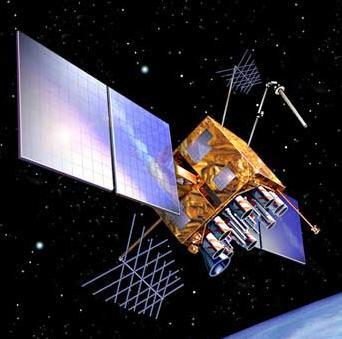
6 What is GPS? A Worldwide Radio-Navigation System 24 Satellites-Constellation Name: NAVSTAR Manufacturer:Rockwell International Altitude:10,900 nautical miles Weight: 1900 lbs (in orbit) Size:17 ft with solar panels extended Orbital Period:12 hours Orbital Plane: 55 degrees to equitorial plane Planned Lifespan:7.5 years Current constellation:24 Block II production satellites Future satellites: 21 Block IIrs developed by Martin Marietta Ground Base Stations *1 nautical mile is approximately miles ( ft)-1 min of arc of the earth s surface GPS Satellites have onboard atomic clocks with an accuracy of 1 nanosecond (1 billionth of a second) These stations monitor the GPS satellites, checking both their operational health and their exact position in space. The master ground station transmits corrections for the satellite's ephemeris constants and clock offsets back to the satellites themselves. The satellites can then incorporate these updates in the signals they send to GPS receivers. There are five monitor stations: Hawaii, Ascension Island, Diego Garcia, Kwajalein, and Colorado Springs.
7 Space Segment 24 Satellites 4 satellites in 6 orbital planes inclined at 55 o 20,200 km above the Earth h 12 hour orbits h Same satellite in view for 4-5 hours h Designed to last 7.5 years h Different Classifications h Block 1, 2, 2A, 2R & 2F 55 o Equator
 5 more stations will be added in the future?")
8 Tracking Facilities 6 Existed stations (yellow color) 6 new stations added (smaller red color) 5 more stations will be added in the future?? (bigger red color)
9 How GPS Works How GPS works can basically be described in 5 logical steps: 1. The basis of GPS is triangulation" from satellites. The word "triangulation" is used very loosely here because it's a word most people can understand, but purists would not call what GPS does "triangulation" because no angles are involved. It's really "trilateration." 2. To "triangulate," a GPS receiver measures distance using the travel time of radio signals. 3. To measure travel time, GPS needs very accurate timing which it achieves with some tricks. 4. Along with distance, you need to know exactly where the satellites are in space. High orbits and careful monitoring are the secret. 5. Finally you must correct for any delays the signal experiences as it travels through the atmosphere.
10 How GPS Works How GPS works can basically be described in 5 logical steps: 1. The basis of GPS is triangulation" from satellites. The word "triangulation" is used very loosely here because it's a word most people can understand, but purists would not call what GPS does "triangulation" because no angles are involved. It's really "trilateration." 2. To use trilateration, a GPS receiver uses the travel time of radio signals Trilateration:methods involve the determination of absolute or relative locations of points by measurement of distances (not angles), using the geometry of spheres or triangles. GPS: measure the ranges (distances) to satellites not to control points. Ranging: the process of determining how far your receiver is from each satellite.
11 Outline Principle : Position The satellites are like Orbiting Control Stations Ranges (distances) are measured to each satellites using time dependent codes Typically GPS receivers use inexpensive clocks. They are much less accurate than the clocks on board the satellites A radio wave travels at the speed of light (Distance = Velocity x Time) Consider an error in the receiver clock 1/10 second error = 30,000 Km error 1/1,000,000 second error = 300 m error
12 Accurate Clocks Necessary Whole System Depends on the Accurate Measure of Signal Time of Travel Calculation Depends on Highly Accurate Clocks Satellites Have Atomic Clocks Accurate but very expensive ($100,000) SVs have up to four atomic clocks Ground Receivers Just Need Consistent Clocks (Quartz Clocks) Leica Geosystems Capture new dimensions. L Geosystems
13 Atomic Clocks Most accurate method for time-keeping ever developed Nanosecond accuracy: sec If satellite and receiver out of sync by 1/100th of a second, distance measurement off by 1860 miles. Leica Geosystems Capture new dimensions. L Geosystems
14 How GPS Works To measure travel time, GPS needs very accurate timing which it achieves with some tricks. Finding the exact time is essential. Distance is a function of the speed of light, electromagnetic signals of stable frequency and elapsed time. Satellite marks the moment the signals depart, the receiver marks the moment they arrive. The difference in sync of the receiver time minus the satellite time is equal to the travel time kinda The GPS signal travel time for a satellite directly overhead is about 0.06 sec. GPS signals provide a receiver with information to measure the range and the position of the satellite (moving 4 km /sec).
15 How GPS Works To measure travel time, GPS needs very accurate timing which it achieves with some tricks. GPS signals carry information for the receiver to solve it s position A GPS signal must communicate to its receiver What time it is on the satellite The instantaneous position of a moving satellite Atmospheric corrections Satellite identification system and location of other satellites (Ephemeris Data) This information is sent from the Ground Monitoring Stations
16 How GPS Works Getting Timing Sync for Accurate Ranging To determine a good range to the satellite we cannot only use the difference between the clocks in the satellite and the gps receiver. Atomic Clock vs. Quartz Clock GPS: One-way, two clocks in a satellite and a receiver need to perfectly synchronized (impossible; one microsecond discrepancy 300 m error)
17 How GPS Works Aligning the Pseudo-Random Code The Pseudo Random Code is a fundamental part of GPS. Physically it's just a very complicated digital code, or in other words, a complicated sequence of "on" and "off" pulses as shown below. The signal is so complicated that it almost looks like random electrical noise. Hence the name "Pseudo-Random." There are several good reasons for that complexity: receiver doesn't accidentally sync up to some other signal. all the satellites can use the same frequency without jamming each other. And it makes it more difficult for a hostile force to jam the system. the Pseudo Random Code gives the DoD a way to control access to the system.
18 Aligning the Psuedo-Random Code for Range
19 Range Determination from Code Observation Pseudoranges (Code) Each satellite sends a unique signal which repeats itself approximately every millisecond Receiver compares self generated signal with received signal From the time difference (dt), a range observation can be determined Receiver clock needs to be synchronized with the satellite clock T Received Code from Satellite Generated Code from Receiver D = V ( T)

20 WAAS Satellites provide on-the-fly differential correctors for stand-alone receivers improving accuracy to +/- 2 m. Leica Geosystems Capture new dimensions. WAAS = FAA s Wide Area Augmentation System L Geosystems
21 GPS Principle : Range Range = Time Taken x Speed of Light Xll Vl
22 Trilateration One satellite determines a location anywhere on a sphere of radius R1. R2 Two satellites give a circle of points at the intersection of the spheres of radii R1 and R2. R1 P Leica Geosystems Capture new dimensions. R3 The third satellites gives an intersection of a sphere of radius R3 with the circle to establish two possible points in space. One point is usually easily discarded. L Geosystems
23 GPS Principle : Point Positioning R3 R1 R2 We are somewhere on a sphere of radius, R1 2 spheres intersect as a circle 3 spheres intersect at a point (Latitude, Longitude and Height)
24 Point Positioning 4 ranges to resolve for Latitude, Longitude, Height & Time It is similar in principle to a resection problem
25 GPS Signal Structure Each GPS satellite transmits a number of signals The signal comprises of two carrier waves (L1 and L2) and two codes (C/A on L1 and P or Y on both L1 and L2) as well as a satellite orbit message(l2c in 2016 & L5 in 2018) Fundamental Frequency MHz 10 x 154 L MHz C/A Code MHz P-Code MHz x 120 L MHz P-Code MHz 50 BPS Satellite Message
26 GPS Signals Carriers L1 and L2 The L1 carrier is MHz and carries both the status message and a pseudo-random code for timing. The L2 carrier is MHz and is used for the more precise military pseudo-random code Pseudo-Random Codes (C/A) Coarse Acquisition Code Basis for civilian GPS use P (Precise) Code Modulates both the L1 and L2 carriers at a 10MHz rate When encrypted by military it becomes the Y code High precision work Navigation Message Low frequency signal added to the L1 codes that gives information about the satellite's orbits, their clock corrections and other system status.
27 Quick Review 1. Distance to a satellite is determined by measuring how long a radio signal takes to reach us from that satellite. 2. To make the measurement, assumethat both the satellite and our receiver are generating the same pseudo-random codes at exactly the same time. 3. By comparing how late the satellite's pseudo-random code appears compared to our receiver's code, determine how long it took to reach us. 4. Multiply that travel time by the speed of light and you've got distance...but there is more!!
28 Solving for a Position and Determination of a Timing Correction Remember that both the satellite and the receiver need to be able to precisely synchronize their pseudo-random codes to make the system work. Code Phase GPS vs. Carrier Phase GPS The secret to achieving perfect timing is making extra measurements and syncing them all up at the same time Much like a big resection If our receiver's clocks were perfect, then all our satellite ranges would intersect at a single point (which is our position). But with imperfect clocks, a fourth measurement, done as a cross-check, will NOT intersect with the first three. So the receiver's computer says "Uh-oh! there is a discrepancy in my measurements. I must not be perfectly synced with universal time. Since any offset from universal time will affect all of our measurements, the receiver looks for a single correction factor that it can subtract from all its timing measurements that would cause them all to intersect at a single point.
29 Solving for a Position and Determination of a Timing Correction That correction brings the receiver's clock back into sync with universal time, and bingo! -you've got atomic accuracy time right in the palm of your hand. Once it has that correction, the receiver applies to all the rest of its measurements and now we've got precise positioning. One consequence of this principle is that any decent GPS receiver will need to have at least four channels so that it can make the four measurements simultaneously. With the pseudo-random code as a rock solid timing sync pulse, and this extra measurement trick to get us perfectly synced to universal time, we have got everything we need to measure our distance to a satellite in space. ***But for the triangulation to work we not only need to know distance, we also need to know exactly where the satellites are.***
30 Satellite Position for Accurate Geodetic Positioning The satellite s orbit (ephemeris) and position is updated by the Ground Control Stations DoD monitors and checks each satellite s exact altitude, position, and speed These errors are called ephemeris errors and are a product of the gravitional pull from the moon, sun, and from the pressure of solar radiation on satellites Once the DoD has measured a satellite's exact position, they relay that information back up to the satellite itself. The satellite then includes this new corrected position information in the timing signals it's broadcasting. So a GPS signal is more than just pseudo-random code for timing purposes. It also contains a navigation message with ephemeris information as well.
31 Another Review 1. To use the satellites as references for range measurementswe need to know exactly where they are. 2. GPS satellites are so high up their orbits are very predictable. 3. Minor variations in their orbits are measured by the Department of Defense. 4. The error information is sent to the satellites, to be transmitted along with the timing signals.
32 The Error Budget
 Satellite Clocks Orbit Errors Ionosphere Troposphere Receiver Noise Multipath 1.5 2.5 5.")
33 Errors in Satellite Measurements Summary of GPS Error Sources Typical Error in Meters (per satellites) Satellite Clocks Orbit Errors Ionosphere Troposphere Receiver Noise Multipath


34 GPS Signal Delays Caused by the Atmosphere IONOSPHERIC DELAY Leica Geosystems Capture new dimensions. TOTAL ATMOSPHERIC DELAY TROPOSPHERIC DELAY HYDROSTATIC DELAY L WET DELAY Geosystems
35 Atmospheric Corrections System Does Not Operate in a Vacuum Ionosphere Band of charged particles surround earth Troposphere Weather Solar Activity (Mostly sun spots) Alters Calculated Position by Delaying Signal from Satellites Leica Geosystems Capture new dimensions. L Geosystems
36 Multipath Errors The reception of the GPS signal via multiple paths than from a direct line of sight (reflection of the GPS signal) Reflected signals at the frequencies used for L1 and L2 tend to be weaker and more diffuse than the directly received signals Different circular polarization -Left hand polarization (multipath signal) Vs. right hand polarization(direct signal)
37 Multipath Errors
38 Antenna design and Multipath Ground Plane (a metal sheet) - Eliminates signals from low elevation angles

39 Antenna design and Multipath Choke ring design - can reduce antenna gain at low elevations 15 cutoff or mask angle
40 Differential and Relative GPS Positioning Base: GPS Receiver occupying a known position (HARN or CORS) Error is eliminated by the use of a correction factor Rover: GPS Receiver used to set new positions Two Types: Static: NOT MOVING Real-Time Kinematic: MOVING
41 Differential GPS (DGPS) For Survey Grade Accuracy Requires two Receivers Base receiver on a known point Rover receiver surveys desired points Infinite number of rover receivers can use the same base station Leica Geosystems Capture new dimensions. L Geosystems


42 Differential GPS X 23 y 23 z 23 x 19 y 19 z 19 x 14 y 14 z 14 x 21 y 21 z 21 Measured: x y z Delta: x y z True: x y z Corrections applied after survey True: x y z Measured: x y z Delta: x y z Leica Geosystems Capture new dimensions. L Geosystems
43 Differential GPS It is possible to determine the position of Rover B in relation to Reference A provided Coordinates of A are known GPS observations are simultaneous h Differential Positioning h eliminates errors in the satellite and receiver clocks h minimizes atmospheric delays h Accuracy 5 mm - 5 m A? B
44 Differential Code / Carrier Phase If using Code only, accuracy is in the range of cm This is typically referred to as DGPS If using Phase or Code & Phase,accuracy is in the order of 5-10 mm + 1ppm A B
45 Range Determination from Phase Observation Phase Observations Wavelength of the signal is 19 cm on L1 and 24 cm on L2 Receiver compares self-generated phase with received phase Number of wavelengths is not known at the time the receiver is switched on (carrier phase ambiguity) As long as you track the satellite, the change in distance can be observed (the carrier phase ambiguity remains constant) Received Satellite Phase Generated Phase from Receiver T R = c T + λn Leica Geosystems Capture new dimensions. L Geosystems
46 Mask Angle (Elevation, Cut-Off Angle) 15 15
 h Includes Lat, Lon, Height & Time h PDOP (Positional) h Includes Lat, Lon & Height h HDOP (Horizontal) h Includes Lat & Lon h VDOP (Vertical)")
47 Dilution of Precision (DOP) - 1/2 h A description of purely geometrical contribution to the uncertainty in a position fix h It is an indicator as to the geometrical strength of the satellites being tracked at the time of measurement h GDOP (Geometrical) h Includes Lat, Lon, Height & Time h PDOP (Positional) h Includes Lat, Lon & Height h HDOP (Horizontal) h Includes Lat & Lon h VDOP (Vertical) h Includes Height only Good GDOP
48 Summary of GPS Positioning Point Positioning : m (1 epoch solution) Differential Code : cm (P Code) 1-5 m (CA Code) Differential Phase : 5 mm + 1 ppm 3 mm ppm (using Choke-Ring Antenna)
49 Differential GPS Correction
50 Real-Time Kinematic Positioning
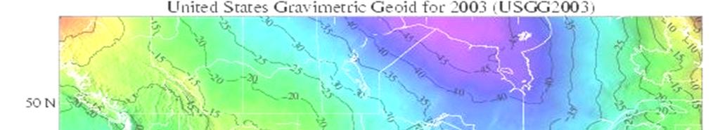
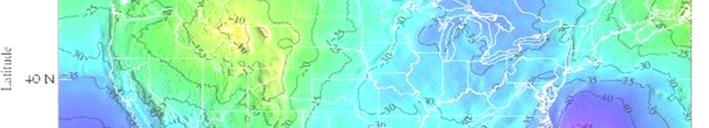
51 Geoid The equipotential surface of the Earth s gravity field which best fits, in the least squares sense, (global) mean sea level. * Geoid surface is neither visible or directly measureable. Geoid is mathematically related to and modeled from gravity data. A geoid height is the ellipsoidal height from an ellipsoidal datum to a geoid. Hence, geoid height models are directly tied to the geoid and ellipsoid that define them (i.e., geoid height models are not interchangeable). *Definition from the Geodetic Glossary, September 1986 Daniel R. Roman, National Geodetic Survey, National Oceanic and Atmospheric Administration
52 Geoid H = Orthometric Height (NAVD 88) h = Ellipsoidal Height (NAD 83) N = Geoid Height (GEOID 03) H = h - N h TOPOGRAPHIC SURFACE Ellipsoid (NAD 83) A Geoid (NAVD 88) H N Geoid Height (GEOID03) B
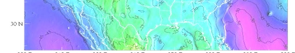
53
54 Geoid DESIGNATION - LEV MAINT PID - DE9009 STATE/COUNTY- IL/CHAMPAIGN USGS QUAD - THOMASBORO (1975) *CURRENT SURVEY CONTROL * NAD 83(2007) (N) (W) ADJUSTED * NAVD (meters) 730. (feet) GPS OBS ELLIP HEIGHT (meters) (02/10/07) ADJUSTED GEOID HEIGHT (meters) GEOID03 SUPERSEDED SURVEY CONTROL ELLIP H (12/06/04) (m) ELLIP H (12/18/02) (m)
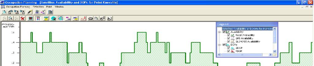
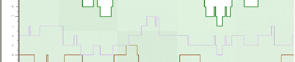

55 Occupational Planning
56 1996: NAD 83 Development Continuously Operating Reference Station (CORS) network becomes a datum.

57 Continuously Operating Reference Stations The CORS system enables positioning accuracies that approach a few centimeters relative to the National Spatial Reference System, both horizontally and vertically. Surveyors, GIS/LIS professionals, and engineers can apply CORS data to position points at which GPS data have been collected. The National Geodetic Survey (NGS) coordinates two CORS networks: the National CORS network and the Cooperative CORS network.

58 Regional CORS Network ign/tdotgnss.html

59 National CORS Network Installed and Operated by various Federal-State-local Agencies NOAA/National Geodetic Survey NOAA/OAR Global Systems Division U.S. Coast Guard - DGPS/NDGPS Corps of Engineers - DGPS FAA - WAAS/LAAS State DOTs County and City Academia Private Companies

60 Real-Time Kinematic: : Today 10 km 2 cm accuracy Leica Geosystems Capture new dimensions. L1 Code and Carrier L2 Carrier Data Link L Geosystems

61 CORS Tower

62 National CORS Network NGS PROVIDES Horizontal and Vertical NSRS Connections NAD 83 and ITRF00 Coordinates Network Data Collection -Hourly & Daily Daily 3D Network Integrity Adjustment Public Data Distribution - Internet 13 Year On-Line Data Holding
63 In Summary 4 satellites needed for accurate timing Once timing is achieved an accurate position can be calculated A GPS solution without a correction is an Autonomous Solution with a varying accuracy of +/- 3m. To obtain a correction we apply a technique called differential positioning. This involves two gps recievers (at a minimum) One base, one rover for RTK, Static can have many base stations
64 In Summary Differential Positioning can be done Static or in Real Time Kinematic (RTK) Static yields much higher accuracies and should be used for control networks RTK is still accurate, but not for traversable control. This method is best used for general topo, and construction surveying, but not control.
65 In Summary In Differential Positioning one GPS unit will occupy a known point or station. This is your base. The rover will occupy the point that you wish to know the position. The base will transmit the correction to the rover in a rtk setup either by radio, or by internet (CORS). In a static setup data for the CORS base stations are downloaded after the occupation and used to post process the rover s position.
66 In Summary STATIC Not moving Higher accuracies Used for control work Base can be either another gps unit occupying a higher order control point or a CORS. This solution is post processed using office software after the occupation Typical occupation times can be 10 min + 2 min/mile of baseline
67 In Summary RTK Real Time Kinematic On the move Lower accuracy, but still survey grade, +/-.06 Used for general survey and construction surveying Base can be another gps unit transmitting a correction by radio, or a CORS with a correction available over the internet. VRS (virtual reference station) is a multiple CORS correction factor that is available over the internet. This is used on where very long base lines are encountered using a CORS network correction factor.
Global Positioning Systems - GPS
 Global Positioning Systems - GPS GPS Why? What is it? How does it work? Differential GPS How can it help me? GPS Why?? Where am I? How do I get there? Where are you, and how do I get to You? WHO CARES???
GLOBAL POSITIONING SYSTEMS. Knowing where and when
 GLOBAL POSITIONING SYSTEMS Knowing where and when Overview Continuous position fixes Worldwide coverage Latitude/Longitude/Height Centimeter accuracy Accurate time Feasibility studies begun in 1960 s.
The Global Positioning System
 The Global Positioning System 5-1 US GPS Facts of Note DoD navigation system First launch on 22 Feb 1978, fully operational in 1994 ~$15 billion (?) invested to date 24 (+/-) Earth-orbiting satellites
GPS Milestones, cont. GPS Milestones. The Global Positioning Sytem, Part 1 10/10/2017. M. Helper, GEO 327G/386G, UT Austin 1. US GPS Facts of Note
 The Global Positioning System US GPS Facts of Note DoD navigation system First launch on 22 Feb 1978, fully operational in 1994 ~$15 billion (?) invested to date 24 (+/-) Earth-orbiting satellites (SVs)
FieldGenius Technical Notes GPS Terminology
 FieldGenius Technical Notes GPS Terminology Almanac A set of Keplerian orbital parameters which allow the satellite positions to be predicted into the future. Ambiguity An integer value of the number of
What is a GPS How does GPS work? GPS Segments GPS P osition Position Position Accuracy Accuracy Accuracy GPS A pplications Applications Applications
 What is GPS? What is a GPS How does GPS work? GPS Segments GPS Position Accuracy GPS Applications What is GPS? The Global Positioning System (GPS) is a precise worldwide radio-navigation system, and consists
GLOBAL POSITIONING SYSTEMS
 GLOBAL POSITIONING SYSTEMS GPS & GIS Fall 2017 Global Positioning Systems GPS is a general term for the navigation system consisting of 24-32 satellites orbiting the Earth, broadcasting data that allows
Errors in GPS. Errors in GPS. Geodetic Co-ordinate system. R. Khosla Fall Semester
 Errors in GPS Errors in GPS GPS is currently the most accurate positioning system available globally. Although we are talking about extreme precision and measuring distances by speed of light, yet there
CARRIER PHASE VS. CODE PHASE
 DIFFERENTIAL CORRECTION Code phase processing- GPS measurements based on the pseudo random code (C/A or P) as opposed to the carrier of that code. (1-5 meter accuracy) Carrier phase processing- GPS measurements
PRINCIPLES AND FUNCTIONING OF GPS/ DGPS /ETS ER A. K. ATABUDHI, ORSAC
 PRINCIPLES AND FUNCTIONING OF GPS/ DGPS /ETS ER A. K. ATABUDHI, ORSAC GPS GPS, which stands for Global Positioning System, is the only system today able to show you your exact position on the Earth anytime,
Global Positioning Systems (GPS) Trails: the achilles heel of mapping from the air / satellites
 Trails: the achilles heel of mapping from the air / satellites") Global Positioning Systems (GPS) Trails: the achilles heel of mapping from the air / satellites Google maps updated regularly by local users using GPS Also: http://openstreetmaps.org GPS applications
Global Positioning Systems (GPS) Trails: the achilles heel of mapping from the air / satellites Google maps updated regularly by local users using GPS Also: http://openstreetmaps.org GPS applications
GPS Tutorial Trimble Home > GPS Tutorial > How GPS works? > Triangulating
 http://www.trimble.com/gps/howgps-triangulating.shtml Page 1 of 3 Trimble Worldwide Popula PRODUCTS & SOLUTIONS SUPPORT & TRAINING ABOUT TRIMBLE INVESTORS GPS Tutorial Trimble Home > GPS Tutorial > How
Resection. We can measure direction in the real world! Lecture 10: Position Determination. Resection Example: Isola, Slovenia. Professor Keith Clarke
 Geography 12: Maps and Spatial Reasoning Lecture 10: Position Determination We can measure direction in the real world! Professor Keith Clarke Resection Resection Example: Isola, Slovenia Back azimuth
Chapter 6 GPS Relative Positioning Determination Concepts
 Chapter 6 GPS Relative Positioning Determination Concepts 6-1. General Absolute positioning, as discussed earlier, will not provide the accuracies needed for most USACE control projects due to existing
GNSS 101 Bringing It Down To Earth
 GNSS 101 Bringing It Down To Earth Steve Richter Frontier Precision, Inc. UTM County Coordinates NGVD 29 State Plane Datums Scale Factors Projections Session Agenda GNSS History & Basic Theory Coordinate
GPS and Recent Alternatives for Localisation. Dr. Thierry Peynot Australian Centre for Field Robotics The University of Sydney
 GPS and Recent Alternatives for Localisation Dr. Thierry Peynot Australian Centre for Field Robotics The University of Sydney Global Positioning System (GPS) All-weather and continuous signal system designed
GPS Errors. Figure 1. Four satellites are required to determine a GPS position.
 Expl ai ni nggps:thegl obalposi t i oni ngsyst em since a minimum of four satellites is required to calculate a position (Fig 1). However, many newer GPS receivers are equipped to receive up to 12 satellite
NR402 GIS Applications in Natural Resources
 NR402 GIS Applications in Natural Resources Lesson 5 GPS/GIS integration Global Positioning System (GPS)..a global navigation system that everyone can use What is GPS? How does it work? How accurate is
Utilizing A GNSS Network Solution for Utility Applications
 Utilizing A GNSS Network Solution for Utility Applications David Newcomer, PE, PLS GPServ, Inc. newcomer@ (407) 601-5816 AGENDA Types and accuracies of data collection o Autonomous o Meter + o Sub-meter
GPS: The Basics. Darrell R. Dean, Jr. Civil and Environmental Engineering West Virginia University. Expected Learning Outcomes for GPS
 GPS: The Basics Darrell R. Dean, Jr. Civil and Environmental Engineering West Virginia University Expected Learning Outcomes for GPS Explain the acronym GPS Name 3 important tdt dates in history of GPS
ENGI 3703 Surveying and Geomatics
 Satellite Geometry: Satellites well spread out in the sky have a much stronger solution to the resection type problem (aka trilateration) then satellite that are grouped together. Since the position of
ELEMENTS OF THE NATIONAL SPATIAL REFERENCE SYSTEM
 Dave Doyle NGS Chief Geodetic Surveyor dave.doyle@noaa.gov 301-713-3178 ELEMENTS OF THE NATIONAL SPATIAL REFERENCE SYSTEM ESRI SURVEY SUMMIT San Diego, CA June 17, 2007 ftp://ftp.ngs.noaa.gov/dist/daved/esri
GNSS Surveying & Processing (A Surveyors Peek Behind the Curtain) Presented by Jeff Clark, PLS
 Presented by Jeff Clark, PLS") GNSS Surveying & Processing (A Surveyors Peek Behind the Curtain) Presented by Jeff Clark, PLS Global Positioning System (GPS) (GNSS) GPS is considered a passive system Passive in the sense that only the
GNSS Surveying & Processing (A Surveyors Peek Behind the Curtain) Presented by Jeff Clark, PLS Global Positioning System (GPS) (GNSS) GPS is considered a passive system Passive in the sense that only the
GLOBAL NAVIGATION SATELLITE SYSTEMS (GNSS) ECE 2526E Tuesday, 24 April 2018
 ECE 2526E Tuesday, 24 April 2018") GLOBAL NAVIGATION SATELLITE SYSTEMS (GNSS) ECE 2526E Tuesday, 24 April 2018 MAJOR GLOBAL NAVIGATION SATELLITE SYSTEMS (GNSS) Global Navigation Satellite System (GNSS) includes: 1. Global Position System
GLOBAL NAVIGATION SATELLITE SYSTEMS (GNSS) ECE 2526E Tuesday, 24 April 2018 MAJOR GLOBAL NAVIGATION SATELLITE SYSTEMS (GNSS) Global Navigation Satellite System (GNSS) includes: 1. Global Position System
GNSS & Coordinate Systems
 GNSS & Coordinate Systems Matthew McAdam, Marcelo Santos University of New Brunswick, Department of Geodesy and Geomatics Engineering, Fredericton, NB May 29, 2012 Santos, 2004 msantos@unb.ca 1 GNSS GNSS
Introduction to Geographic Information Science. Last Lecture. Today s Outline. Geography 4103 / GNSS/GPS Technology
 Geography 4103 / 5103 Introduction to Geographic Information Science GNSS/GPS Technology Last Lecture Geoids Ellipsoid Datum Projection Basics Today s Outline GNSS technology How satellite based navigation
What is GPS? GPS Position Accuracy. GPS Applications. What is a GPS. How does GPS work? GPS Segments
 What is GPS? What is a GPS How does GPS work? GPS Segments GPS Position Accuracy GPS Applications 1 What is GPS? The Global Positioning System (GPS) is a precise worldwide radio-navigation system, and
t =1 Transmitter #2 Figure 1-1 One Way Ranging Schematic
 1.0 Introduction OpenSource GPS is open source software that runs a GPS receiver based on the Zarlink GP2015 / GP2021 front end and digital processing chipset. It is a fully functional GPS receiver which
Entity Tracking and Surveillance using the Modified Biometric System, GPS-3
 Advance in Electronic and Electric Engineering. ISSN 2231-1297, Volume 3, Number 9 (2013), pp. 1115-1120 Research India Publications http://www.ripublication.com/aeee.htm Entity Tracking and Surveillance
Fundamentals of GPS Navigation
 Fundamentals of GPS Navigation Kiril Alexiev 1 /76 2 /76 At the traditional January media briefing in Paris (January 18, 2017), European Space Agency (ESA) General Director Jan Woerner explained the knowns
Global Positioning System: what it is and how we use it for measuring the earth s movement. May 5, 2009
 Global Positioning System: what it is and how we use it for measuring the earth s movement. May 5, 2009 References Lectures from K. Larson s Introduction to GNSS http://www.colorado.edu/engineering/asen/
GPS Basics. Introduction to GPS (Global Positioning System) Version 1.0 English
 Version 1.0 English") 20 30 40 50 GPS Basics Introduction to GPS (Global Positioning System) Version 1.0 English Contents Preface... 4 1. What is GPS and what does it do?... 5 2. System Overview... 6 2.1 The Space Segment...
20 30 40 50 GPS Basics Introduction to GPS (Global Positioning System) Version 1.0 English Contents Preface... 4 1. What is GPS and what does it do?... 5 2. System Overview... 6 2.1 The Space Segment...
Using RTK GNSS Wisely
 Using RTK GNSS Wisely February 017 Autonomous Positioning Differential Positioning Concept: Detect and cancel identical errors with simultaneous observation. F + E = G + E 1 Static & RTK Computations Static
Introduction to the Global Positioning System
 GPS for Fire Management - 2004 Introduction to the Global Positioning System Pre-Work Pre-Work Objectives Describe at least three sources of GPS signal error, and identify ways to mitigate or reduce those
CHAPTER 2 GPS GEODESY. Estelar. The science of geodesy is concerned with the earth by quantitatively
 CHAPTER 2 GPS GEODESY 2.1. INTRODUCTION The science of geodesy is concerned with the earth by quantitatively describing the coordinates of each point on the surface in a global or local coordinate system.
GPS Global Positioning System
 GPS Global Positioning System 10.04.2012 1 Agenda What is GPS? Basic consept History GPS receivers How they work Comunication Message format Satellite frequencies Sources of GPS signal errors 10.04.2012
Introduction. Global Positioning System. GPS - Intro. Space Segment. GPS - Intro. Space Segment - Contd..
 Introduction Global Positioning System Prof. D. Nagesh Kumar Dept. of Civil Engg., IISc, Bangalore 560 012, India URL: http://www.civil.iisc.ernet.in/~nagesh GPS is funded and controlled by U. S. Department
UNIT 1 - introduction to GPS
 UNIT 1 - introduction to GPS 1. GPS SIGNAL Each GPS satellite transmit two signal for positioning purposes: L1 signal (carrier frequency of 1,575.42 MHz). Modulated onto the L1 carrier are two pseudorandom
36. Global Positioning System
 36. Introduction to the Global Positioning System (GPS) Why do we need GPS? Position: a basic need safe sea travel, crowed skies, resource management, legal questions Positioning: a challenging job local
GPS for. Land Surveyors. Jan Van Sickle. Fourth Edition. CRC Press. Taylor & Francis Group. Taylor & Francis Croup, an Informa business
 GPS for Land Surveyors Fourth Edition Jan Van Sickle CRC Press Taylor & Francis Group Boca Raton London New York CRC Press is an imprint of the Taylor & Francis Croup, an Informa business Contents Preface
Introduction to NAVSTAR GPS
 Introduction to NAVSTAR GPS Charlie Leonard, 1999 (revised 2001, 2002) The History of GPS Feasibility studies begun in 1960 s. Pentagon appropriates funding in 1973. First satellite launched in 1978. System
High Precision GNSS for Mapping & GIS Professionals
 High Precision GNSS for Mapping & GIS Professionals Agenda Address your needs for GNSS knowledge. GNSS Basics Satellite Ranging Fundamentals (Code $ Carrier) Differential Corrections (Post Processed $
Introduction to the Global Positioning System
 GPS for ICS - 2003 Introduction to the Global Positioning System Pre-Work Pre-Work Objectives Describe at least three sources of GPS signal error, and ways to mitigate or reduce those errors. Identify
GPS STATIC-PPP POSITIONING ACCURACY VARIATION WITH OBSERVATION RECORDING INTERVAL FOR HYDROGRAPHIC APPLICATIONS (ASWAN, EGYPT)
") GPS STATIC-PPP POSITIONING ACCURACY VARIATION WITH OBSERVATION RECORDING INTERVAL FOR HYDROGRAPHIC APPLICATIONS (ASWAN, EGYPT) Ashraf Farah Associate Professor,College of Engineering, Aswan University,
GPS STATIC-PPP POSITIONING ACCURACY VARIATION WITH OBSERVATION RECORDING INTERVAL FOR HYDROGRAPHIC APPLICATIONS (ASWAN, EGYPT) Ashraf Farah Associate Professor,College of Engineering, Aswan University,
Lecture 04. Elements of Global Positioning Systems
 Lecture 04 Elements of Global Positioning Systems Elements of GPS: During the last lecture class we talked about Global Positioning Systems and its applications. With so many innumerable applications of
Wednesday AM: (Doug) 2. PS and Long Period Signals
 2. PS and Long Period Signals") Wednesday AM: (Doug) 2 PS and Long Period Signals What is Colorado famous for? 32 satellites 12 Early on in the world of science synchronization of clocks was found to be important. consider Paris: puffs
Wednesday AM: (Doug) 2 PS and Long Period Signals What is Colorado famous for? 32 satellites 12 Early on in the world of science synchronization of clocks was found to be important. consider Paris: puffs
Proceedings of Al-Azhar Engineering 7 th International Conference Cairo, April 7-10, 2003.
 Proceedings of Al-Azhar Engineering 7 th International Conference Cairo, April 7-10, 2003. MODERNIZATION PLAN OF GPS IN 21 st CENTURY AND ITS IMPACTS ON SURVEYING APPLICATIONS G. M. Dawod Survey Research
What is it? History. Other systems. How does it work? Trilateration GEOG 201 4/28/2010. Instructor: Pesses 1. {06} The Global Positioning System
 What is it? {06} The Global Positioning System G.P.S. = Global Positioning System Different from G.I.S. (Geographic Information Systems) Map Interpretation & GPS Spring 2010 M. Pesses History Conceived
Asian Journal of Science and Technology Vol. 08, Issue, 11, pp , November, 2017 RESEARCH ARTICLE
 Available Online at http://www.journalajst.com ASIAN JOURNAL OF SCIENCE AND TECHNOLOGY ISSN: 0976-3376 Asian Journal of Science and Technology Vol. 08, Issue, 11, pp.6697-6703, November, 2017 ARTICLE INFO
An Introduction to GPS
 An Introduction to GPS You are here The GPS system: what is GPS Principles of GPS: how does it work Processing of GPS: getting precise results Yellowstone deformation: an example What is GPS? System to
Principal Investigator Co-Principal Investigator Co-Principal Investigator Prof. Talat Ahmad Vice-Chancellor Jamia Millia Islamia Delhi
 Subject Paper No and Title Module No and Title Module Tag Geology Remote Sensing and GIS Concepts of Global Navigation Satellite RS & GIS XXXIII Principal Investigator Co-Principal Investigator Co-Principal
The GLOBAL POSITIONING SYSTEM James R. Clynch February 2006
 The GLOBAL POSITIONING SYSTEM James R. Clynch February 2006 I. Introduction What is GPS The Global Positioning System, or GPS, is a satellite based navigation system developed by the United States Defense
PDHonline Course L105 (12 PDH) GPS Surveying. Instructor: Jan Van Sickle, P.L.S. PDH Online PDH Center
 GPS Surveying. Instructor: Jan Van Sickle, P.L.S. PDH Online PDH Center") PDHonline Course L105 (12 PDH) GPS Surveying Instructor: Jan Van Sickle, P.L.S. 2012 PDH Online PDH Center 5272 Meadow Estates Drive Fairfax, VA 22030-6658 Phone & Fax: 703-988-0088 www.pdhonline.org www.pdhcenter.com
PDHonline Course L105 (12 PDH) GPS Surveying Instructor: Jan Van Sickle, P.L.S. 2012 PDH Online PDH Center 5272 Meadow Estates Drive Fairfax, VA 22030-6658 Phone & Fax: 703-988-0088 www.pdhonline.org www.pdhcenter.com
Table of Contents. Frequently Used Abbreviation... xvii
 GPS Satellite Surveying, 2 nd Edition Alfred Leick Department of Surveying Engineering, University of Maine John Wiley & Sons, Inc. 1995 (Navtech order #1028) Table of Contents Preface... xiii Frequently
GPS Accuracies in the Field
 GPS Accuracies in the Field A short and informative talk by A. Richard Vannozzi, PLS Assistant Professor of Civil Technology/Surveying and Mapping Thompson School of Applied Science University of New Hampshire
PDHonline Course L105 (12 PDH) GPS Surveying. Instructor: Jan Van Sickle, P.L.S. PDH Online PDH Center
 GPS Surveying. Instructor: Jan Van Sickle, P.L.S. PDH Online PDH Center") PDHonline Course L105 (12 PDH) GPS Surveying Instructor: Jan Van Sickle, P.L.S. 2012 PDH Online PDH Center 5272 Meadow Estates Drive Fairfax, VA 22030-6658 Phone & Fax: 703-988-0088 www.pdhonline.org www.pdhcenter.com
PDHonline Course L105 (12 PDH) GPS Surveying Instructor: Jan Van Sickle, P.L.S. 2012 PDH Online PDH Center 5272 Meadow Estates Drive Fairfax, VA 22030-6658 Phone & Fax: 703-988-0088 www.pdhonline.org www.pdhcenter.com
Global Navigation Satellite Systems II
 Global Navigation Satellite Systems II AERO4701 Space Engineering 3 Week 4 Last Week Examined the problem of satellite coverage and constellation design Looked at the GPS satellite constellation Overview
The Global Positioning System II Field Experiments
 The Global Positioning System II Field Experiments 5-1 Mexico DGPS Field Campaign Cenotes in Tamaulipas, MX, near Aldama 5-2 Are Cenote Water Levels Related? 5-3 DGPS Static Survey of Cenote Water Levels
ENGRG Introduction to GIS
 ENGRG 59910 Introduction to GIS Michael Piasecki December 01, 2017 Lecture 12: GPS Systems Lecture 7: Introduction To GPS November 27, 2017 ENGRG 59910 Intro to GIS 2 November 27, 2017 ENGRG 59910 Intro
TEST YOUR SATELLITE NAVIGATION PERFORMANCE ON YOUR ANDROID DEVICE GLOSSARY
 TEST YOUR SATELLITE NAVIGATION PERFORMANCE ON YOUR ANDROID DEVICE GLOSSARY THE GLOSSARY This glossary aims to clarify and explain the acronyms used in GNSS and satellite navigation performance testing
Modelling GPS Observables for Time Transfer
 Modelling GPS Observables for Time Transfer Marek Ziebart Department of Geomatic Engineering University College London Presentation structure Overview of GPS Time frames in GPS Introduction to GPS observables
Introduction to Datums James R. Clynch February 2006
 Introduction to Datums James R. Clynch February 2006 I. What Are Datums in Geodesy and Mapping? A datum is the traditional answer to the practical problem of making an accurate map. If you do not have
Sources of Geographic Information
 Sources of Geographic Information Data properties: Spatial data, i.e. data that are associated with geographic locations Data format: digital (analog data for traditional paper maps) Data Inputs: sampled
GE 113 REMOTE SENSING
 GE 113 REMOTE SENSING Topic 9. Introduction to Global Positioning Systems (GPS) and Other GNSS Technologies Lecturer: Engr. Jojene R. Santillan jrsantillan@carsu.edu.ph Division of Geodetic Engineering
The Global Positioning Sytem II 10/19/2017
 The Global Positioning System II Field Experiments 10/19/2017 5-1 Mexico DGPS Field Campaign Cenotes in Tamaulipas, MX, near Aldama 10/19/2017 5-2 Are Cenote Water Levels Related? 10/19/2017 5-3 M. Helper,
UNITED NATIONS UNIVERSITY Institute for Environment & Human Security (UNU-EHS) Bonn, Germany
 Bonn, Germany") UNITED NATIONS UNIVERSITY Institute for Environment & Human Security (UNU-EHS) Bonn, Germany Introduction to GPS technology Prof. Dr. Jörg Szarzynski Education Programme Director Head of Section EduSphere
UNITED NATIONS UNIVERSITY Institute for Environment & Human Security (UNU-EHS) Bonn, Germany Introduction to GPS technology Prof. Dr. Jörg Szarzynski Education Programme Director Head of Section EduSphere
Lecture-1 CHAPTER 2 INTRODUCTION TO GPS
 Lecture-1 CHAPTER 2 INTRODUCTION TO GPS 2.1 History of GPS GPS is a global navigation satellite system (GNSS). It is the commonly used acronym of NAVSTAR (NAVigation System with Time And Ranging) GPS (Global
Hitchhiker s s Guide Global Position System. Global Position System
 Hitchhiker s s Guide Global Position System Myles Sutherland Craig Greenwald Mike Shaw John Rogers Hitchhiker s s Guide Global Position System (GPS) Myles Sutherland - ESRI Craig Greenwald ESRI John Rogers
Basics of Satellite Navigation an Elementary Introduction Prof. Dr. Bernhard Hofmann-Wellenhof Graz, University of Technology, Austria
 Basics of Satellite Navigation an Elementary Introduction Prof. Dr. Bernhard Hofmann-Wellenhof Graz, University of Technology, Austria CONCEPT OF GPS Prof. Dr. Bernhard Hofmann-Wellenhof Graz, University
ESTIMATION OF IONOSPHERIC DELAY FOR SINGLE AND DUAL FREQUENCY GPS RECEIVERS: A COMPARISON
 ESTMATON OF ONOSPHERC DELAY FOR SNGLE AND DUAL FREQUENCY GPS RECEVERS: A COMPARSON K. Durga Rao, Dr. V B S Srilatha ndira Dutt Dept. of ECE, GTAM UNVERSTY Abstract: Global Positioning System is the emerging
Challenges and Solutions for GPS Receiver Test
 Challenges and Solutions for GPS Receiver Test Presenter: Mirin Lew January 28, 2010 Agenda GPS technology concepts GPS and GNSS overview Assisted GPS (A-GPS) Basic tests required for GPS receiver verification
Principles of. Principles of GPS 9/12/2011
 Principles of GPS How the Global Positioning System works is, conceptually, really very simple The GPS system is based on a distance measuring (satellite ranging) system That means that we find our position
Datums for a Dynamic Earth
 Datums for a Dynamic Earth Based on a paper given at the American Society of Agricultural and Biological Engineers (ASABE) Conference in Reno, Nevada June 2009 Rollin StrohmanPh.D. Tom Mastin L.S Background
Introduction to GNSS
 Introduction to GNSS Dimitrios Bolkas, Ph.D. Department of Surveying Engineering, Pennsylvania State University, Wilkes Barre Campus PSLS Surveyor s Conference Hershey, PA Global Navigation Satellite System
Geodesy, Geographic Datums & Coordinate Systems
 Geodesy, Geographic Datums & Coordinate Systems What is the shape of the earth? Why is it relevant for GIS? 1/23/2018 2-1 From Conceptual to Pragmatic Dividing a sphere into a stack of pancakes (latitude)
GPS Glossary Written by Carl Carter SiRF Technology 2005
 GPS Glossary Written by Carl Carter SiRF Technology 2005 This glossary provides supplementary information for students of GPS Fundamentals. While many of the terms can have other definitions from those
LAB PROCEDURES: TOPCON TOOLS FAMILIARIZATION
 LAB PROCEDURES: TOPCON TOOLS FAMILIARIZATION This lab will cover the basic setup and processing options of Topcon Tools (TT). We will learn how to start a project, upload data and control files, set up
Effect of Quasi Zenith Satellite (QZS) on GPS Positioning
 on GPS Positioning") Effect of Quasi Zenith Satellite (QZS) on GPS ing Tomoji Takasu 1, Takuji Ebinuma 2, and Akio Yasuda 3 Laboratory of Satellite Navigation, Tokyo University of Marine Science and Technology 1 (Tel: +81-5245-7365,
Effect of Quasi Zenith Satellite (QZS) on GPS ing Tomoji Takasu 1, Takuji Ebinuma 2, and Akio Yasuda 3 Laboratory of Satellite Navigation, Tokyo University of Marine Science and Technology 1 (Tel: +81-5245-7365,
How is GPS Used in Farming? Equipment Guidance Systems
 GPS Applications in Crop Production John Nowatzki, Extension Geospatial Specialist, Vern Hofman, Extension Ag Engineer Lowell Disrud, Assistant Professor, Kraig Nelson, Graduate Student Introduction The
2 INTRODUCTION TO GNSS REFLECTOMERY
 2 INTRODUCTION TO GNSS REFLECTOMERY 2.1 Introduction The use of Global Navigation Satellite Systems (GNSS) signals reflected by the sea surface for altimetry applications was first suggested by Martín-Neira
GPS: What do I need to collect Application Appropriate location data?
 GPS: What do I need to collect Application Appropriate location data? Bob Goodwin, GISP GIS/Remote Sensing Analyst Remote Sensing & GIS Research and Outreach Services, MSU http://www.rsgis.msu.edu 2005
2. GPS and GLONASS Basic Facts
 2. GPS and GLONASS Basic Facts In 1973 the U.S. Department of Defense decided to establish, develop, test, acquire, and deploy a spaceborne Global Positioning System (GPS). The result of this decision
What makes the positioning infrastructure work. Simon Kwok Chairman, Land Surveying Division Hong Kong Institute of Surveyors
 What makes the positioning infrastructure work The experience of the Hong Kong Satellite Positioning Reference Station Network Simon Kwok Chairman, Land Surveying Division Hong Kong Institute of Surveyors
GPS POSITIONING GUIDE
 GPS POSITIONING GUIDE (July 1993) Third printing July 1995 This product is available from: Natural Resources Canada* Geomatics Canada Geodetic Survey Division Information Services 615 Booth Street Ottawa,
Introduction to Total Station and GPS
 Introduction to Total Station and GPS Dr. P. NANJUNDASWAMY Professor of Civil Engineering J S S Science and Technology University S J College of Engineering Mysuru 570 006 Introduction History GPS Overview
DYNAMIC RT TECHNOLOGY
 DYNAMIC RT TECHNOLOGY GLOBAL NAVIGATION SATELLITE SYSTEMS (GNSS) POTENTIAL FUTURE DEVELOPMENTS(2005 2017?) GPS MODERNIZATION BLOCK IIF & III GLONASS ENHANCEMENTS (K & M) EUROPEAN UNION - GALILEO CHINA
Digital Land Surveying and Mapping (DLS and M) Dr. Jayanta Kumar Ghosh Department of Civil Engineering Indian Institute of Technology, Roorkee
 Dr. Jayanta Kumar Ghosh Department of Civil Engineering Indian Institute of Technology, Roorkee") Digital Land Surveying and Mapping (DLS and M) Dr. Jayanta Kumar Ghosh Department of Civil Engineering Indian Institute of Technology, Roorkee Lecture 11 Errors in GPS Observables Welcome students. Lesson
Digital Land Surveying and Mapping (DLS and M) Dr. Jayanta Kumar Ghosh Department of Civil Engineering Indian Institute of Technology, Roorkee Lecture 11 Errors in GPS Observables Welcome students. Lesson
Introduction to GNSS
 Introduction to GNSS Dimitrios Bolkas, Ph.D. Department of Surveying Engineering, Pennsylvania State University, Wilkes Barre Campus PSLS Surveyor s Conference January 21-24, 2018 Hershey, PA Global Navigation
The Global Positioning System II Field Experiments. 10/10/2013 GEO327G/386G, UT Austin 5-1
 The Global Positioning System II Field Experiments 10/10/2013 GEO327G/386G, UT Austin 5-1 Mexico DGPS Field Campaign Cenotes in Tamaulipas, MX, near Aldama 10/10/2013 GEO327G/386G, UT Austin 5-2 Are Cenote
GNSS: orbits, signals, and methods
 Part I GNSS: orbits, signals, and methods 1 GNSS ground and space segments Global Navigation Satellite Systems (GNSS) at the time of writing comprise four systems, two of which are fully operational and
Math 215 Project 1 (25 pts) : Using Linear Algebra to solve GPS problem
 : Using Linear Algebra to solve GPS problem") Due 11:55pm Fri. Sept. 28 NAME(S): Math 215 Project 1 (25 pts) : Using Linear Algebra to solve GPS problem 1 Introduction The age old question, Where in the world am I? can easily be solved nowadays by
Due 11:55pm Fri. Sept. 28 NAME(S): Math 215 Project 1 (25 pts) : Using Linear Algebra to solve GPS problem 1 Introduction The age old question, Where in the world am I? can easily be solved nowadays by
Basics of Satellite Navigation an Elementary Introduction Prof. Dr. Bernhard Hofmann-Wellenhof Graz, University of Technology, Austria
 Basics of Satellite Navigation an Elementary Introduction Prof. Dr. Bernhard Hofmann-Wellenhof Graz, University of Technology, Austria Basic principles 1.1 Definitions Satellite geodesy (SG) comprises
Line and polygon features can be created via on-screen digitizing.
 This module explains how GPS works, sources of error, and error correction using real time or post processing differential correction. Cost and accuracy of different grades of GPS units are also part of
Procedures for Quality Control of GNSS Surveying Results Based on Network RTK Corrections.
 Procedures for Quality Control of GNSS Surveying Results Based on Network RTK Corrections. Limin WU, China Feng xia LI, China Joël VAN CRANENBROECK, Switzerland Key words : GNSS Rover RTK operations, GNSS
Lecture # 7 Coordinate systems and georeferencing
 Lecture # 7 Coordinate systems and georeferencing Coordinate Systems Coordinate reference on a plane Coordinate reference on a sphere Coordinate reference on a plane Coordinates are a convenient way of
GPS Error and Biases
 Component-I(A) - Personal Details Role Name Affiliation Principal Investigator Prof.MasoodAhsanSiddiqui Department of Geography, JamiaMilliaIslamia, New Delhi Paper Coordinator, if any Dr. Mahaveer Punia
Datums and Tools to Connect Geospatial Data Accurately
 Datums and Tools to Connect Geospatial Data Accurately Pamela Fromhertz Colorado State Geodetic Advisor National Geodetic Survey National Oceanic and Atmospheric Administration GIS-T April 18, 2012 Loveland,
GPS Technical Overview N5TWP NOV08. How Can GPS Mislead
 GPS Technical Overview How Can GPS Mislead 1 Objectives Components of GPS Satellite Acquisition Process Position Determination How can GPS Mislead 2 Components of GPS Control Segment Series of monitoring
GLONASS-based Single-Frequency Static- Precise Point Positioning
 GLONASS-based Single-Frequency Static- Precise Point Positioning Ashraf Farah College of Engineering Aswan University Aswan, Egypt e-mail: ashraf_farah@aswu.edu.eg Abstract Precise Point Positioning (PPP)
TDS Survey Pro CE Version Setup RTK Base on known NAD83/WGS84 Point: Mapping Plane Geoid99 Modeling.
 TDS Survey Pro CE Version 2.1.8 Setup RTK Base on known NAD83/WGS84 Point: Mapping Plane Geoid99 Modeling. Pre-load known NAD83 State Plane Coordinates and appropriate NGS Geoid 99/96 data files into the