Datums for a Dynamic Earth
|
|
|
- Wesley Watts
- 5 years ago
- Views:
Transcription
1 Datums for a Dynamic Earth Based on a paper given at the American Society of Agricultural and Biological Engineers (ASABE) Conference in Reno, Nevada June 2009 Rollin StrohmanPh.D. Tom Mastin L.S
2 Background The Agricultural and Biological Engineers (ASABE) Precision Agriculture group was discussing standards One standard being considered was all Field control should be on Absolute unchanging Coordinates This brought about a paper presented at the American Society of Agricultural and Biological Engineers (ASABE) Conference in Reno, Nevada June 2009» Datums for a Dynamic Earth
3 Precision Agriculture Precision Agriculture is a generic term for Using Precision Machine Control Using positioning systems for crop and soil studies Using GIS and remote sensing for farm management
4 Precision Agriculture Control In regards to: precision machine control Looking at maintaining repeatability Is it possible to create the row in the same location ±1 foot Year after year Is it possible to?? Give coordinates that will define your property boundary using GPS Dig up water valves based on locations done in the 1980 s
5 GPS Precision Plain GPS =10 20m (33 to 66ft) Corrected GPS WAAS =1.5m (5 ft) Coast Guard = 1 to 3m (3.3 to 9.9ft) Omnistar VBS XP HP John Deere CPD Starfire SF1 Starfire SF2 RTK Static = 1m (3.3ft) = 0.15m (0.5ft) = 0.10m (0.33ft) = 0.75m (2.5ft) = 0.25m (0.8ft) =0.02m (.06ft) =0.01m (0.03ft)
6 Problem Solved? Corrected GPS XP HP John Deere CPD Starfire SF1 Starfire SF2 RTK Static = 0.15m (0.5ft) = 0.10m (0.33ft) = 0.75m (2.5ft) = 0.25m (0.8ft) =0.02m (.06ft) =0.01m (0.03ft)
7 Earth is Dynamic Not only does the earth Orbit Spin Wobble It also Modulates & changes shape

8 Dynamic Earth Plate Tectonics San Andreas Fault
9 Tides Earth Tides The earth s surface elevation changes due to Forces of attraction between earth, moon & sun
10 Subsidence More then 17,000 Square miles in 45 states Have been directly effected by subsidence San Joaquin Valley Dropped 30 feet in 75 years
11 Other rapid impacts Earthquakes Volcanos Haiti Paso Robles Mt. St. Helens
12 Slides Not to Mention
13 Positioning on the Earth s surface Topographic Surface Ellipsoidal Surface Geoid Surface
14 Earth s Shape Earth is best represented as an Oblate triaxial Ovaloid Earth is generally mathematically represented as an oblate spheroid Ellipsoid of Revolution
15 Datums A Geodisist way to look at the earth Datum is a mathematical model and parameters that define and fix a coordinate system that is realized by measurements between and positions assigned to a reference frame of physical monuments
16 Datums we like? NAD 27 NGVD 29 NAD 83 NAVD 88 WGS 84
17 How we make datums workable Projections Convert 3D model to 2D model Coordinate Systems Series of Projections
18 What Datum Systems Use GPS WGS84 [G1150] National Spatial Reference System NAD83 (NSRS2007) CORS (Official) ITRF00 NAD83(CORS96) OmniStar VBS NAD83 HP & XP ITRF2005
19 Who Uses What Coordinate System Land Surveyors NAD83 State Plane Coordinates Geophyisists ITRF 2005 or IGS05 Military WGS84 Earthquake Group (North America) SNARF People who don t care about high precision UTM People in California who don t care about high Precision Teale Albers
20 Datum Positions NAD83 Tied to the North American Plate Adjustments 1986 (Original) (HARN/HPGN/1992) NSRS2007 WGS84 Tied to a worldwide framework Adjustments G730 G1150
21 How do we relate to NAD83 We use the National Spatial Reference System (NSRS) 300,000 Horizontal Control Points 600,000 Vertical Control Points National Geodetic Surveys (NGS) has Data sheets Coordinate values for Position Datum Position Projection Position
22 How do we relate to WGS 84 WGS 84 For Civilians Use GPS Can use Transformation software to compute value from NAD83 Position Transformations are estimations
23 California Geographic Information Association Geodetic control provides a common reference system for establishing coordinates for all geographic data. All NSDI framework data and users applications data require geodetic control to accurately register spatial data. The National Spatial Reference System is the fundamental geodetic control for the United States. From the California Geospatial Framework Data Draft Plan

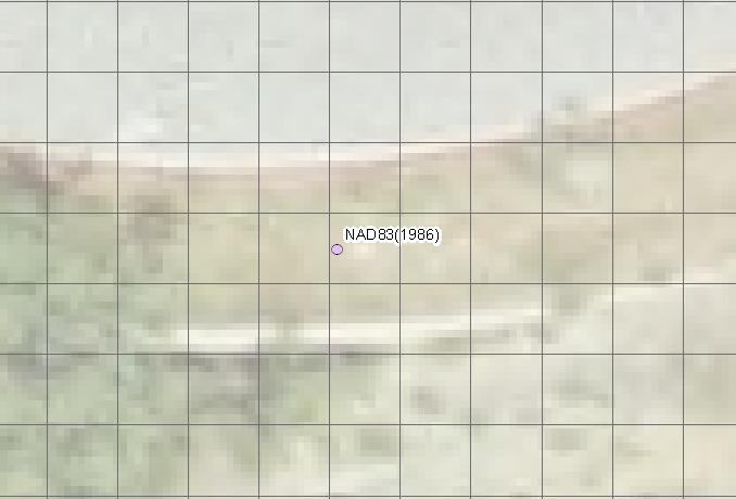
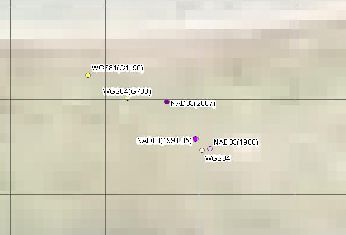
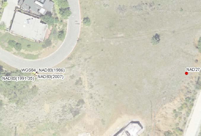
24 Positions of Monterey
25 Back to the Original Question Can I get Repeatability Can I get 1 foot repeatability over 10 years If I use OmniStar No If I use Deere StarFire No If I use NGS NSRS Maybe not If I use CORS Station Maybe not If I use City of SLO Network Possibly If I use my own Local Control Possibly


26 Not everyone agrees with me
27 The National Geodetic Survey 10 year plan Mission, Vision and Strategy Official NGS policy as of Jan 9, 2008 Modernized agency Attention to accuracy Attention to time-changes Improved products and services Integration with other fed missions Vetted through NSPS/AAGS 2018 Targets: NAD 83 and NAVD 88 re-defined Cm-accuracy access to all coordinates Customer-focused agency Global scientific leadership Borrowed from David Doyle s Fundamentals of the National Spatial Reference System
28 PREDICTED POSITIONAL FOR CHANGES DATUMS IN 2018 (Computed at R 15 (pid HV1789) HORIZONTAL = 1.06 m (3.5 ft) ELLIPSOID HEIGHT = m (- 4.3 ft) Predicted with HTDP ORTHOMETRIC HEIGHT = m (- 1.3 ft) Predicted with HTDP and USGG2003 Borrowed from David Doyle s Fundamentals of the National Spatial Reference System
29 Repeatability with NSRS Repeat a position I established in 1992 In 1992 used NAD83( ) Option 1 Tie into 2007 Control (Say Monterey) Use Horizontal Time Dependent Positioning Software (HTDP) Convert today s coordinate to 1992 Option 2 Use the control and coordinates that were originally used
30 Monterey What if I am using City Control to tie into NSRS Difference of 2.2ft 1.5ft
31 What do we do? Precise location requires defining Datum Adjustment Date State Law requires certain actions if indicating using NAD83 or NSRS data Tie into a minimum of two B order or better control Use the epoch as defined by NGS for those control points
32 Where are we going We don t know There are groups like UNAVCO NGS NGA That are actively monitoring Datum and earth movement Through CORS and other Stations There has been talk of getting rid of NAD83 In favor of ITRF or something else It seems to be likes meters
ELEMENTS OF THE NATIONAL SPATIAL REFERENCE SYSTEM
 Dave Doyle NGS Chief Geodetic Surveyor dave.doyle@noaa.gov 301-713-3178 ELEMENTS OF THE NATIONAL SPATIAL REFERENCE SYSTEM ESRI SURVEY SUMMIT San Diego, CA June 17, 2007 ftp://ftp.ngs.noaa.gov/dist/daved/esri
An NGS Illustrated Guide to Geodesy for GIS Professionals
 An NGS Illustrated Guide to Geodesy for GIS Professionals Michael Dennis, RLS, PE michael.dennis@noaa.gov Esri User Conference San Diego Convention Center July 14-18, 2014 San Diego, CA Why should we care
Overview of New Datums NOAA s National Geodetic Survey
 Overview of New Datums NOAA s National Geodetic Survey February 3, 2015 1 NGS s Mission and Role NGS Mission: To define, maintain, and provide access to the National Spatial Reference System to meet our
Datums and Tools to Connect Geospatial Data Accurately
 Datums and Tools to Connect Geospatial Data Accurately Pamela Fromhertz Colorado State Geodetic Advisor National Geodetic Survey National Oceanic and Atmospheric Administration GIS-T April 18, 2012 Loveland,
Introduction to Datums James R. Clynch February 2006
 Introduction to Datums James R. Clynch February 2006 I. What Are Datums in Geodesy and Mapping? A datum is the traditional answer to the practical problem of making an accurate map. If you do not have
GNSS & Coordinate Systems
 GNSS & Coordinate Systems Matthew McAdam, Marcelo Santos University of New Brunswick, Department of Geodesy and Geomatics Engineering, Fredericton, NB May 29, 2012 Santos, 2004 msantos@unb.ca 1 GNSS GNSS
Determining Accurate Elevations: Datums & Tools, Today & Tomorrow
 Determining Accurate Elevations: Datums & Tools, Today & Tomorrow Association of State Floodplain Managers Annual Meeting Grand Rapids, MI Christine Gallagher June 21, 2016 Overview NGS Mission Important
Overview of New Datums
 Overview of New Datums Scott Lokken NC Advisor NOAA s National Geodetic Survey 9/4/2015 1 New Datums are Coming in 2022! Both a new geometric and a new geopotential (vertical) datum will be released in
Utilizing A GNSS Network Solution for Utility Applications
 Utilizing A GNSS Network Solution for Utility Applications David Newcomer, PE, PLS GPServ, Inc. newcomer@ (407) 601-5816 AGENDA Types and accuracies of data collection o Autonomous o Meter + o Sub-meter
Lecture 14 NAD 83(NSRS), NAD 83(CORS 96), WGS84 and ITRF
, NAD 83(CORS 96), WGS84 and ITRF") Lecture 14 NAD 83(NSRS), NAD 83(CORS 96), WGS84 and ITRF Monday, March 1, 2010 2 March 2010 GISC3325 NAD 27 and NAD 83 NAD 27 and NAD 83 Versions of NAD 83 First implementation labeled NAD 83 (1986). Deficiencies
Lecture 14 NAD 83(NSRS), NAD 83(CORS 96), WGS84 and ITRF Monday, March 1, 2010 2 March 2010 GISC3325 NAD 27 and NAD 83 NAD 27 and NAD 83 Versions of NAD 83 First implementation labeled NAD 83 (1986). Deficiencies
Connecting a Cadastral Survey to PNG94 using GNSS
 43rd Association of Surveyors PNG Congress, Lae, 12th-15th August 2009 Connecting a Cadastral Survey to PNG94 using GNSS Richard Stanaway QUICKCLOSE Workshop overview Legal requirements to connect surveys
GNSS 101 Bringing It Down To Earth
 GNSS 101 Bringing It Down To Earth Steve Richter Frontier Precision, Inc. UTM County Coordinates NGVD 29 State Plane Datums Scale Factors Projections Session Agenda GNSS History & Basic Theory Coordinate
Connecting a Survey to PNG94 and MSL using GNSS
 45th Association of Surveyors PNG Congress, Madang, 19-22 July 2011 Connecting a Survey to PNG94 and MSL using GNSS Richard Stanaway QUICKCLOSE Workshop overview Legal requirements to connect surveys to
Determining Accurate Elevations: Datums & Tools, Today & Tomorrow
 Determining Accurate Elevations: Datums & Tools, Today & Tomorrow Maryland Association Floodplain and Stormwater Managers Linthicum Heights, MD Christine Gallagher Oct. 20, 2016 Overview NGS Mission Important
Datum Transformations: Nightmare on GIS Street. Agenda
 Datum Transformations: Nightmare on GIS Street Speaker: Eric Gakstatter Contributing Editor GPS World Editor - Geospatial Solutions Presented at: Minnesota Society of Professional Surveyors Bloomington,
Understanding the Evolution of WGS 84 and NAD 83
 Summary Both WGS 84, the datum used by GPS,, commonly used in North America, have been redefined several times since their beginning. Parallel to this, there have also been several realizations of the
GNSS Technology Update
 GNSS Technology Update Speaker: Eric Gakstatter Contributing Editor GPS World Editor - Geospatial Solutions Presented at: Association of Petroleum Surveying & Geomatics Houston, TX April 7, 2015 Agenda
High Precision GNSS for Mapping & GIS Professionals
 High Precision GNSS for Mapping & GIS Professionals Agenda Address your needs for GNSS knowledge. GNSS Basics Satellite Ranging Fundamentals (Code $ Carrier) Differential Corrections (Post Processed $
GEODESY LESSON PLAN Meet Geodesy
 Meet Lesson Plan GEODESY LESSON PLAN Meet Focus Introduction to geodesy Grade Level 9-12 Focus Question What is geodesy, and why is it important? Learning Objectives Students will be able to define geodesy.
Chapter 6 GPS Relative Positioning Determination Concepts
 Chapter 6 GPS Relative Positioning Determination Concepts 6-1. General Absolute positioning, as discussed earlier, will not provide the accuracies needed for most USACE control projects due to existing
Coordinates, Datums, and Map Projection
 Coordinates, Datums, and Map Projection Two views on the World Intersect at 90 o angles Latitude/ Longitude is a Spherical System Acceptable latitudes/longitudes i) W125 o 27 33 ii) N92 o 45 12 iii)
National Height Modernization: Cost comparison of conducting a vertical survey by leveling versus by GPS in western North Carolina
 Introduction: National Height Modernization: Cost comparison of conducting a vertical survey by leveling versus by GPS in western North Carolina The North Carolina Geodetic Survey (NCGS) conducted a National
NSRS Modernization Update
 geodesy.noaa.gov NSRS Modernization Update Scott Lokken National Geodetic Survey, NOAA Mid Atlantic Regional Geodetic Advisor Oct 05, 2017 Maryland Society of Surveyors Fall Conference NGS Regional Geodetic
Geodesy, Geographic Datums & Coordinate Systems
 Geodesy, Geographic Datums & Coordinate Systems What is the shape of the earth? Why is it relevant for GIS? 1/23/2018 2-1 From Conceptual to Pragmatic Dividing a sphere into a stack of pancakes (latitude)
Lecture # 7 Coordinate systems and georeferencing
 Lecture # 7 Coordinate systems and georeferencing Coordinate Systems Coordinate reference on a plane Coordinate reference on a sphere Coordinate reference on a plane Coordinates are a convenient way of
Using GPS to Establish the NAVD88 Elevation on Reilly The A-order HARN Station at NMSU
 Using GPS to Establish the NAVD88 Elevation on Reilly The A-order HARN Station at NMSU Earl F. Burkholder, PS, PE New Mexico State University Las Cruces, NM 88003 July 005 Introduction GPS has become an
DYNAMIC RT TECHNOLOGY
 DYNAMIC RT TECHNOLOGY GLOBAL NAVIGATION SATELLITE SYSTEMS (GNSS) POTENTIAL FUTURE DEVELOPMENTS(2005 2017?) GPS MODERNIZATION BLOCK IIF & III GLONASS ENHANCEMENTS (K & M) EUROPEAN UNION - GALILEO CHINA
Basic Geodetics. Bobby Saleh Guidon Energy April 13, 2017
 Experts in Geomatics, Surveying, Positioning, Geospatial Data, and Mapping Sciences Basic Geodetics Bobby Saleh Guidon Energy b.saleh@guidonenergy.com April 13, 2017 The Earth is NOT flat Q: So what does
FieldGenius Technical Notes GPS Terminology
 FieldGenius Technical Notes GPS Terminology Almanac A set of Keplerian orbital parameters which allow the satellite positions to be predicted into the future. Ambiguity An integer value of the number of
A Brief History of the California Spatial Reference Center. Current Status of the California Real-Time Network
 A Brief History of the California Spatial Reference Center October 3, 2014 Ontario, CA October 10, 2014 Oakland, CA Current Status of the California Real-Time Network Art Andrew Past CSRC Chairperson CSRC
Geodetic Reference Frame Theory
 Technical Seminar Reference Frame in Practice, Geodetic Reference Frame Theory and the practical benefits of data sharing Geoffrey Blewitt University of Nevada, Reno, USA http://geodesy.unr.edu Sponsors:
Overview of Recent Tidal Projects in the United States
 1 st Tides and Water Levels Working Group Meeting Overview of Recent Tidal Projects in the United States Stephen Gill National Oceanic and Atmospheric Administration, National Ocean Service Center for
Appendix A Lower Columbia River Chart Datum Modeling
 Appendix A Lower Columbia River Chart Datum Modeling David Evans and Associates, Inc. David Evans and Associates, Inc. 2801 SE Columbia Way, Ste. 130 Vancouver, WA 98661 (360) 314-3200 1.0 Vertical Datum
LAB PROCEDURES: TOPCON TOOLS FAMILIARIZATION
 LAB PROCEDURES: TOPCON TOOLS FAMILIARIZATION This lab will cover the basic setup and processing options of Topcon Tools (TT). We will learn how to start a project, upload data and control files, set up
U.S. Army Corps of Engineers: Review of Progress Toward Consistent Vertical Datums. by Jim Garster and Mark Huber
 U.S. Army Corps of Engineers: Review of Progress Toward Consistent Vertical Datums by Jim Garster and Mark Huber i ii Abstract A vertical datum is the most important part of any geospatial data, no matter
GPS Pathfinder Office Software or the GPS Analyst Extension for ESRI ArcGIS Software: Resolving the NAD 83 Datum Transformation Issue
 Mapping & GIS Support Note 5 May 2005 GPS Pathfinder Office Software or the GPS Analyst Extension for ESRI ArcGIS Software: Resolving the NAD 83 Datum Transformation Issue Summary The current realizations
GPS Pathfinder Office Software or GPS Analyst Extension for ESRI ArcGIS Software: Resolving the NAD 83 Datum Transformation Issue
 13 June 2011 GPS Pathfinder Office Software or GPS Analyst Extension for ESRI ArcGIS Software: Resolving the NAD 83 Datum Transformation Issue Summary The current realizations of the North American Datum
Future of Reference Frames from Static to Dynamic? Markku Poutanen and Pasi Häkli
 Future of Reference Frames from Static to Dynamic? Markku Poutanen and Pasi Häkli Finnish Geospatial Research Institute, FGI Future of Reference Frames from Static to Dynamic? kinematic Markku Poutanen
Lecture 16 NAD 83 (1986), NAD 83(1993) and NAD 83 (NSRS 2007) 10 March 2009 GISC3325
, NAD 83(1993) and NAD 83 (NSRS 2007) 10 March 2009 GISC3325") Lecture 16 NAD 83 (1986), NAD 83(1993) and NAD 83 (NSRS 2007) 10 March 2009 GISC3325 Significant dates 16-20 March 2009 is Spring Break 12 March 2009 is Exam Two Emphasis on chapter 5, 6 and 8 of text
Lecture 16 NAD 83 (1986), NAD 83(1993) and NAD 83 (NSRS 2007) 10 March 2009 GISC3325 Significant dates 16-20 March 2009 is Spring Break 12 March 2009 is Exam Two Emphasis on chapter 5, 6 and 8 of text
Precise Point Positioning (PPP) using
 using") Precise Point Positioning (PPP) using Product Technical Notes // May 2009 OnPOZ is a product line of Effigis. EZSurv is a registered trademark of Effigis. All other trademarks are registered or recognized
Precise Point Positioning (PPP) using Product Technical Notes // May 2009 OnPOZ is a product line of Effigis. EZSurv is a registered trademark of Effigis. All other trademarks are registered or recognized
A NEW GEOCENTRIC DATUM FOR NEW ZEALAND
 A NEW GEOCENTRIC DATUM FOR NEW ZEALAND Don Grant Graeme Blick Office of Surveyor-General Land Information New Zealand PO Box 5501 Wellington New Zealand Phone 04 4600100 Fax 04 4722244 dgrant@linz.govt.nz
Modernization of the National Spatial Reference System Keeping Pace with Changes in Positioning Technology and User Expectations in a Dynamic World
 Modernization of the National Spatial Reference System Keeping Pace with Changes in Positioning Technology and User Expectations in a Dynamic World Wisconsin Society of Land Surveyors Institute Wisconsin
Global Positioning Systems -GPS
 Global Positioning Systems -GPS GPS Why? What is it? How does it work? Differential GPS How can it help me? GPS Why?? Where am I? How do I get there? Where are you, and how do I get to You? WHO CARES???
Global Positioning Systems - GPS
 Global Positioning Systems - GPS GPS Why? What is it? How does it work? Differential GPS How can it help me? GPS Why?? Where am I? How do I get there? Where are you, and how do I get to You? WHO CARES???
Overview of Tides and Water Levels
 Overview of Tides and Water Levels www.tidesandcurrents.noaa.gov New Orleans, Baton Rouge, Lafayette, LA March 2009 Gerald Hovis, NOAA - National Ocean Service William Sweet, NOAA - National Ocean Service
BILL HENNING, Prof LS. ACRONYMS
 BILL HENNING, Prof LS. ACRONYMS US 1 WIKIPEDIA: Also known as geodetics, geodetic engineering or geodetics engineering a branch of applied mathematics [2] and earth sciences, is the scientific discipline
WISCONSIN COORDINATE SYSTEMS
 Pdf versions of the Handout and Powerpoint slides are on jerrymahun.com. Follow the USPLSS Forum link and use the password: WildT2 WISCONSIN COORDINATE SYSTEMS CONCEPTS & IMPLEMENTATION Jerry Mahun, PLS,
Standard for the Australian Survey Control Network
 Standard for the Australian Survey Control Network Special Publication 1 Intergovernmental Committee on Survey and Mapping (ICSM) Geodesy Technical Sub-Committee (GTSC) 30 March 2012 Table of contents
GPS for. Land Surveyors. Jan Van Sickle. Fourth Edition. CRC Press. Taylor & Francis Group. Taylor & Francis Croup, an Informa business
 GPS for Land Surveyors Fourth Edition Jan Van Sickle CRC Press Taylor & Francis Group Boca Raton London New York CRC Press is an imprint of the Taylor & Francis Croup, an Informa business Contents Preface
The Global Positioning System II Field Experiments. 10/10/2013 GEO327G/386G, UT Austin 5-1
 The Global Positioning System II Field Experiments 10/10/2013 GEO327G/386G, UT Austin 5-1 Mexico DGPS Field Campaign Cenotes in Tamaulipas, MX, near Aldama 10/10/2013 GEO327G/386G, UT Austin 5-2 Are Cenote
The Global Positioning System II Field Experiments
 The Global Positioning System II Field Experiments 5-1 Mexico DGPS Field Campaign Cenotes in Tamaulipas, MX, near Aldama 5-2 Are Cenote Water Levels Related? 5-3 DGPS Static Survey of Cenote Water Levels
The Global Positioning Sytem II 10/19/2017
 The Global Positioning System II Field Experiments 10/19/2017 5-1 Mexico DGPS Field Campaign Cenotes in Tamaulipas, MX, near Aldama 10/19/2017 5-2 Are Cenote Water Levels Related? 10/19/2017 5-3 M. Helper,
21st International Conference of The Coastal Society
 21st International Conference of The Coastal Society DEVELOPMENT OF A VERTICAL DATUM TRANSFORMATION TOOL AND A BATHYMETRIC/TOPOGRAPHIC DIGITAL ELEVATION MODEL FOR SOUTHERN CALIFORNIA Edward P. Myers, NOAA/NOS
GPS for GIS Data Collection - 101
 GPS for GIS Data Collection - 101 Speaker: Eric Gakstatter, Editor of GPS World s Survey Scene Newsletter & Geospatial Solutions Guest Commentator: Craig Greenwald, Technical Director, GeoMobile Innovations,
GROUND CONTROL SURVEY REPORT
 GROUND CONTROL SURVEY REPORT Services provided by: 3001, INC. a Northrop Grumman company 10300 Eaton Place Suite 340 Fairfax, VA 22030 Ground Control Survey in Support of Topographic LIDAR, RGB Imagery
Benefits and Impacts to Nautical Charting by Adopting a New Reference Frame. Dr. Neil Weston Office of Coast Survey, NOAA
 Benefits and Impacts to Nautical Charting by Adopting a New Reference Frame Dr. Neil Weston Office of Coast Survey, NOAA Motivation for this study NOAA s National Geodetic Survey New geometric reference
TECHNICAL REPORT NO. 45 TECHNICAL REVIEW AND REEVALUATION OF THE REGIONAL CONTROL SURVEY PROGRAM IN SOUTHEASTERN WISCONSIN
 TECHNICAL REPORT NO. 45 TECHNICAL REVIEW AND REEVALUATION OF THE REGIONAL CONTROL SURVEY PROGRAM IN SOUTHEASTERN WISCONSIN SOUTHEASTERN WISCONSIN REGIONAL PLANNING COMMISSION SOUTHEASTERN WISCONSIN REGIONAL
GPS Errors. Figure 1. Four satellites are required to determine a GPS position.
 Expl ai ni nggps:thegl obalposi t i oni ngsyst em since a minimum of four satellites is required to calculate a position (Fig 1). However, many newer GPS receivers are equipped to receive up to 12 satellite
9/26/2016. Accuracy with GNSS What are you getting? Presented By Tom Bryant PLS Kelly Harris PLS Seiler Instrument
 Accuracy with GNSS What are you getting? Presented By Tom Bryant PLS Kelly Harris PLS Seiler Instrument 1 What We Will Talk About Today What coordinate system should I use in my data collector Site Calibrations-what
Salient Feature of ITRF. Realization of Dubai Emirate Datum. Reference Frame 2000 (Ditr 2000)
") Salient Feature of ITRF on the Reference Frame 2000 (Ditr 2000) ITRF stands for International Terrestrial Reference Frame ITRF established by the International Earth Rotation Service (IERS), France. One
Salient Feature of ITRF on the Reference Frame 2000 (Ditr 2000) ITRF stands for International Terrestrial Reference Frame ITRF established by the International Earth Rotation Service (IERS), France. One
NGA s Support for Positioning and Navigation
 NGA s Support for Positioning and Navigation PNT Symposium 6 November 2007 Barbara Wiley NATIONAL GEOSPATIAL-INTELLIGENCE AGENCY What is NGA and What Do We Do? National Geospatial-Intelligence Agency (NGA)
What makes the positioning infrastructure work. Simon Kwok Chairman, Land Surveying Division Hong Kong Institute of Surveyors
 What makes the positioning infrastructure work The experience of the Hong Kong Satellite Positioning Reference Station Network Simon Kwok Chairman, Land Surveying Division Hong Kong Institute of Surveyors
Using RTK GNSS Wisely
 Using RTK GNSS Wisely February 017 Autonomous Positioning Differential Positioning Concept: Detect and cancel identical errors with simultaneous observation. F + E = G + E 1 Static & RTK Computations Static
CHAPTER 5 Vertical Control. CE 316 January 2012
 CHAPTER 5 Vertical Control CE 316 January 01 137 5.1 Introduction Vertical Datums Leveling Techniques and Corrections Bench Mark Design and Construction Bench Mark Data Trigonometric Barometric Leveling
TDS Ranger Survey Pro CE Version RTK Base on known Control Point. RTK Rover - Localization with Control Points.
 TDS Ranger Survey Pro CE Version 2.1.8 RTK Base on known Control Point. RTK Rover - Localization with Control Points. Pre-load control Coordinates and appropriate NGS Geoid 99/96 data files into the Ranger
Instruction with Hands-on Practice: Creating a Bathymetric Database & Datum Conversion
 Instruction with Hands-on Practice: Creating a Bathymetric Database & Datum Conversion Tanya Beck Coastal and Hydraulics Laboratory Engineer Research and Development Center May 17, 2010 US Army Corps of
The coordinate system and vertical datum shall be noted in the drawing in the metadata.
 Purpose This document is provided for informational purposes and to assure data compatibility and compliance for as-built drawings or vector data formats specifically for the 354th Civil Engineer Squadron
Traffic and Roadway Improvements - Rte 123 (Belmont Street) Brockton, MA Client: BETA Group, Inc.
 Brockton, MA Client: BETA Group, Inc.") HIGHWAY PROJECT EXPERIENCE Traffic and Roadway Improvements - Rte 123 (Belmont Street) Brockton, MA Client: BETA Group, Inc. Alpha provided survey services to prepare a base plan of an approximately 2900
HIGHWAY PROJECT EXPERIENCE Traffic and Roadway Improvements - Rte 123 (Belmont Street) Brockton, MA Client: BETA Group, Inc. Alpha provided survey services to prepare a base plan of an approximately 2900
CHAPTER 2 GEODESY AND DATUMS IN NAVIGATION
 CHAPTER 2 GEODESY AND DATUMS IN NAVIGATION GEODESY, THE BASIS OF CARTOGRAPHY 200. Definition Geodesy is the application of mathematics to model the size and shape of the physical earth, enabling us to
Geodetic Positioning Refresher
 Geodetic Positioning Refresher by Joan Yau PhD ABCLS AGM 2016, Kimberley BC Contents Horizontal / Vertical Datums and Epochs used in BC and Canada How do we reference our project coordinates to BC datums
GPS Geodetic Reference System WGS 84
 GPS Geodetic Reference System WGS 84 International Committee on GNSS Working Group D Saint Petersburg, Russia 16 September 2009 Barbara Wiley National Geospatial-Intelligence Agency United States of America
INTEGRATING BATHYMETRY, TOPOGRAPHY, AND SHORELINE, AND THE IMPORTANCE OF VERTICAL DATUMS
 INTEGRATING BATHYMETRY, TOPOGRAPHY, AND SHORELINE, AND THE IMPORTANCE OF VERTICAL DATUMS Bruce Parker, Dennis Milbert, Kurt Hess, and Stephen Gill National Ocean Service, NOAA 1315 East-West Highway Silver
Standard for New Zealand Vertical Datum 2016 LINZS25009
 Standard for New Zealand Vertical Datum 2016 LINZS25009 Effective Date: 27 June 2016 Table of Contents TERMS ND DEFINITIONS... 3 FOREWORD... 5 INTRODUCTION... 5 PURPOSE OF STNDRD... 5 BRIEF HISTORY OF
NJDEP GPS Data Collection Standards for GIS Data Development
 NJDEP GPS Data Collection Standards for GIS Data Development Bureau of Geographic Information Systems Office of Information Resource Management April 24 th, 2017 Table of Contents 1.0 Introduction... 3
AUSPOS GPS Processing Report
 AUSPOS GPS Processing Report February 13, 2012 This document is a report of the GPS data processing undertaken by the AUSPOS Online GPS Processing Service (version: AUSPOS 2.02). The AUSPOS Online GPS
WAAS/LPV Flight Inspection and the Importance of Database Integrity and Standardization
 WAAS/LPV Flight Inspection and the Importance of Database Integrity and Standardization Gary A. Flynn Engineering Manager Aviation System Standards Federal Aviation Administration Oklahoma City, Oklahoma,
Philippine Geodetic Infrastructure Status, Challenges and Future Direction
 Philippine Geodetic Infrastructure Status, Challenges and Future Direction Engr. Charisma Victoria D. Cayapan National Mapping and Resource Information Authority PHILIPPINES Outline Evolution of Geodetic
Beginners Guide to GPS Elevation Plus an Update on GPS Technology
 Beginners Guide to GPS Elevation Plus an Update on GPS Technology A TMS Presentation By: Jon Aschenbach Summerlake Enterprises 919 36 th Place Forest Grove, OR 97116 503-707-6236 Coeur d Alene, ID April,
Connecting a Survey to PNG94 and MSL using GNSS
 Connecting a Survey to PNG94 and MSL using GNSS Richard Stanaway, Quickclose, PO Box 1364, Carlton, VIC, 3053, AUSTRALIA email: richard.stanaway@quickclose.com.au This is an essential workshop for surveyors
Errors in GPS. Errors in GPS. Geodetic Co-ordinate system. R. Khosla Fall Semester
 Errors in GPS Errors in GPS GPS is currently the most accurate positioning system available globally. Although we are talking about extreme precision and measuring distances by speed of light, yet there
GPS STATIC-PPP POSITIONING ACCURACY VARIATION WITH OBSERVATION RECORDING INTERVAL FOR HYDROGRAPHIC APPLICATIONS (ASWAN, EGYPT)
") GPS STATIC-PPP POSITIONING ACCURACY VARIATION WITH OBSERVATION RECORDING INTERVAL FOR HYDROGRAPHIC APPLICATIONS (ASWAN, EGYPT) Ashraf Farah Associate Professor,College of Engineering, Aswan University,
GPS STATIC-PPP POSITIONING ACCURACY VARIATION WITH OBSERVATION RECORDING INTERVAL FOR HYDROGRAPHIC APPLICATIONS (ASWAN, EGYPT) Ashraf Farah Associate Professor,College of Engineering, Aswan University,
BILL HENNING, Prof LS.
 BILL HENNING, Prof LS. DEFINITIONS: GEODESY, DATUMS, NSRS ACCESSING THE DATUM REALIZATION: PASSIVE MARKS, ACTIVE STATIONS WORLD SCIENTIFIC DATUMS HORIZONTAL, GEOMETRIC, VERTICAL, GRAVIMETRIC DATUMS IN
GPS Technical Aspects
 GPS Technical Aspects Charles Ghilani (cghilani@psu.edu) Turn off all cell phones Or set them to vibrate Class Etiquette Ask questions at any point during the class. Simply speak up so that all can hear
Application of GPS/GNSS in Cybermapping. Cybermapping Lab University of Texas at Dallas 2009
 Application of GPS/GNSS in Cybermapping Cybermapping Lab University of Texas at Dallas 2009 GNSS Global Navigation Satellite System (GNSS) is the standard generic term for satellite navigation systems
Accuracy assessment of free web-based online GPS Processing services and relative GPS solution software
 82 Accuracy assessment of free web-based online GPS Processing services and relative GPS solution software Khaled Mahmoud Abdel Aziz Department of Surveying Engineering, Shoubra Faculty of Engineering,
Choosing the best path:
 GEODESY Choosing the best path: Global to national coordinate transformations The paper demonstrates that differences of up to a few centimetres in each coordinate component can occur depending on the
NR402 GIS Applications in Natural Resources
 NR402 GIS Applications in Natural Resources Lesson 5 GPS/GIS integration Global Positioning System (GPS)..a global navigation system that everyone can use What is GPS? How does it work? How accurate is
Applications, Products and Services of GPS Technology
 Applications, Products and Services of GPS Technology Enrico C. Paringit. Dr. Eng. University of the Philippines Training Center for Applied Geodesy and Photogrammetry 1 Outline of this Presentation GPS
ENGI 3703 Surveying and Geomatics
 Satellite Geometry: Satellites well spread out in the sky have a much stronger solution to the resection type problem (aka trilateration) then satellite that are grouped together. Since the position of
VERTICAL DATUM TRANSFORMATIONS FOR KINEMATIC GPS HYDROGRAPHIC SURVEYS. Kurt W. Hess, Dennis G. Milbert, Stephen K. Gill, and Daniel R.
 VERTICAL DATUM TRANSFORMATIONS FOR KINEMATIC GPS HYDROGRAPHIC SURVEYS Kurt W. Hess, Dennis G. Milbert, Stephen K. Gill, and Daniel R. Roman National Ocean Service, NOAA ABSTRACT Kinematic Global Positioning
NATIONAL VDATUM -- THE IMPLEMENTATION OF A NATIONAL VERTICAL DATUM TRANSFORMATION DATABASE
 NATIONAL VDATUM -- THE IMPLEMENTATION OF A NATIONAL VERTICAL DATUM TRANSFORMATION DATABASE Bruce Parker, Dennis Milbert, Kurt Hess, and Stephen Gill National Ocean Service, NOAA The National Ocean Service
Geodetic policy for Ireland and Northern Ireland
 Geodetic policy for Ireland and Northern Ireland Background Ordnance Survey Ireland (OSi) is the National Mapping Agency (NMA) of the Republic of Ireland. The Ordnance Survey of Northern Ireland (OSNI)
Who s heard of the GDA2020?
 Implications of a next generation datum in Australia on mining operations: A discussion. School of Civil & Environmental Engineering Craig Roberts Senior lecturer Surveying and Geospatial Engineering group
FORMED IN LESS THAN 20ö OF LESS OVER SILTY LOAM GLACIAL TILL. : (IGNEOUS/METAMORPHIC/SEDIMENTARY) : (1-10 cm/11-50 cm/ cm/over 200 cm)
 : (1-10 cm/11-50 cm/ cm/over 200 cm)") 0. Form Prepared by (full name) : ROBERT SCHULDT Date Prepared : 2010-10-22 Report Type : NEW If Update: Previous Site Log : (ssss_ccyymmdd.log) Modified/Added Sections : (n.n,n.n,...) 1. Site Identification
0. Form Prepared by (full name) : ROBERT SCHULDT Date Prepared : 2010-10-22 Report Type : NEW If Update: Previous Site Log : (ssss_ccyymmdd.log) Modified/Added Sections : (n.n,n.n,...) 1. Site Identification
BATHYMETRIC DATA AND NAUTICAL CHART DATUMS
 Distr. LIMITED ECA/NRD/CART.9/USA.2 October 1996 Original: ENGLISH Ninth United Nations Regional Cartographic Conference for Africa Addis Ababa, Ethiopia 11-15 November 1996 A GLOBAL APPROACH TO UPDATE
Baldwin and Mobile Counties, AL Orthoimagery Project Report. Submitted: March 23, 2016
 2015 Orthoimagery Project Report Submitted: Prepared by: Quantum Spatial, Inc 523 Wellington Way, Suite 375 Lexington, KY 40503 859-277-8700 Page i of iii Contents Project Report 1. Summary / Scope...
ELEVATION DETERMINATIONS ALONG A CANAL
 ELEVATION DETERMINATIONS ALONG A CANAL IN CENTRAL CALIFORNIA N. Barbella and M. Berber Department of Civil and Geomatics Engineering California State University, Fresno, California, U.S.A. 1. Introduction
PREFACE. National Geographic Department would like to express our sincere thanks for your comments.
 PREFACE According to the role of National Geographic Department on Prim Minister s Decree No 255 PM, dated August 16, 2005 regarding to Surveying, Aerial Photography and mapping activities in the territory
IMAGINE StereoSAR DEM TM
 IMAGINE StereoSAR DEM TM Accuracy Evaluation age 1 of 12 IMAGINE StereoSAR DEM Product Description StereoSAR DEM is part of the IMAGINE Radar Mapping Suite and is designed to auto-correlate stereo pairs
New Zealand Reference Frame Case Study
 New Zealand Reference Frame Case Study Graeme Blick Chief Geodesist Land Information New Zealand 1 Fundamental role of the reference frame Requirements of a National Reference System A coordinate framework