Instruction with Hands-on Practice: Creating a Bathymetric Database & Datum Conversion
|
|
|
- Corey Stanley
- 5 years ago
- Views:
Transcription


1 Instruction with Hands-on Practice: Creating a Bathymetric Database & Datum Conversion Tanya Beck Coastal and Hydraulics Laboratory Engineer Research and Development Center May 17, 2010 US Army Corps of Engineers BUILDING STRONG
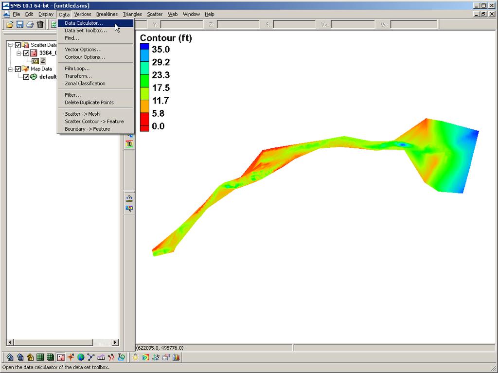
 Datum Conversion SMS conversion (Corpscon; Global Mapper)")
2 Introduction to Bathymetric Databases in SMS Introduction to working with bathymetric datasets Importing Datasets (xyz, points, shapefiles, other ascii) Datum Conversion SMS conversion (Corpscon; Global Mapper) 2
 Channel NJ State maintains")
 NAN-supported field data collection Included bathymetry of the backbay (Spring")
3 Multiple Bathymetric Datasets Limited bay bathymetry NOAA Offshore datasets LIDAR Shoreline and nearshore (important for structure resolution) Channel NJ State maintains north channel and north bay channel Federally maintained entrance and south channel (15 years) NAN-supported field data collection Included bathymetry of the backbay (Spring High Tide) 3


 Vertical")

 Need")
4 Common Spatial Reference Datum & Vertical Datum Horizontal Projection & Datum: Pick a system in metric units that is planar (UTM; State Plane) Vertical Projection & Datum: Must be in metric as well; Datum is not necessary (Local) Need to convert all bathymetric data 4
")

5 Tides and Currents (NOAA) _retrieve.shtml?type=datums 5
 NGVD 29 1.59 ft (0.485 m) NAN Surveys MLW MSL + 2.76 ft (0.841 m) 1.9 ft (0.579 m) MLW 0.18 ft (0.")
6 Vertical Datum Conversions NOAA (Long Branch) COE NAN Benchmark MSL 0.24 ft (0.073 m) NAVD ft (0.686 m) 1.1 ft (0.335 m) NGVD ft (0.485 m) NAN Surveys MLW MSL ft (0.841 m) 1.9 ft (0.579 m) MLW 0.18 ft (0.055 m) MLLW 6
7 Prep for the Coastal Modeling System Based off of a Cartesian grid Planar coordinate system Model computation is in metric and depths are positive from zero (elevations are flipped) Grid is generated based off of a single bathymetry file stored in SMS scatterset file format Vertical datum is not specified and is assumed local The boundary condition forcing (tidal) must be in the same datum as the bathymetry Typically modeling grids are brought to a mean datum such as mean sea level (msl) or mean tide level (mtl) This requires that all datasets are brought in to unified projection, datum, and units Shark River Inlet bathymetry will be converted to State Plane horizontal coordinates in meters with the vertical datum set to MSL in meters 7

8 Reprojecting Coordinates and Changing Datums Object Projection tells SMS the present projection. Checking Specify Project Projection is used to change the projection. It will physically change the coordinates of everything loaded in SMS. The projection settings are saved in the SMS project file (*.sms). 8
,")

9 Converting Elevations to Depths (CMS Requirement) Data Transform Can adjust scatterset data by scaling, translating (adding/subtracting), or rotating horizontal or veritcal Select Depths Elevations Flips negative elevations to positive depths. Necessary for CMS model calculation. 9

10 NAN Channel Surveys 15 Year Record of Bathymetry Date Survey Type Date Survey Type 1-Jan-1995 Condition 28-Mar-2007 Condition 6-Jan-1998 Condition 30-Aug-2007 Before Dredge 6-May-1999 Condition 4-Jan-2008 After Dredge 11-Apr-2000 Condition 25-Mar-2008 Condition 16-Apr-2002 Condition 9-Jun-2008 After Dredge 6-Dec-2002 Before Dredge 31-Oct-2008 After Dredge 18-Jan-2003 After Dredge 8-Dec-2008 Before Dredge 7-Jul-2003 Condition 6-Jan-2009 After Dredge 7-Aug-2003 After Dredge 15-Apr-2009 Before Dredge 28-Apr-2004 Condition 1-May-2009 After Dredge 10-Jun-2005 Condition 20-Aug-2009 Before Dredge 23-Dec-2005 After Dredge 10-Dec-2009 After Dredge 23-May-2006 Condition 6-Jan-2010 After Dredge 27-Nov-2006 Condition Horizontal Datum: State Plane NAD27 New Jersey 2900 (ft) Vertical Datum: MLW (ft) COE Datum (not local NOAA benchmark) 10
11 Conversions NOAA (Long Branch) COE NAN Benchmark MSL 0.24 ft (0.073 m) NAVD ft (0.686 m) 1.1 ft (0.335 m) NGVD ft (0.485 m) 1.9 ft (0.579 m) MLW 0.18 ft (0.055 m) MLLW 11
 Full Channel Survey Horizontal Datum: State Plane NAD27 New Jersey 2900 (ft) Vertical Datum: MLW (ft)")
12 NAN Channel Surveys Extended in to Bay NAN Surveys MLW MSL ft (0.841 m) Full Channel Survey Horizontal Datum: State Plane NAD27 New Jersey 2900 (ft) Vertical Datum: MLW (ft) COE Datum (not local NOAA benchmark) 12
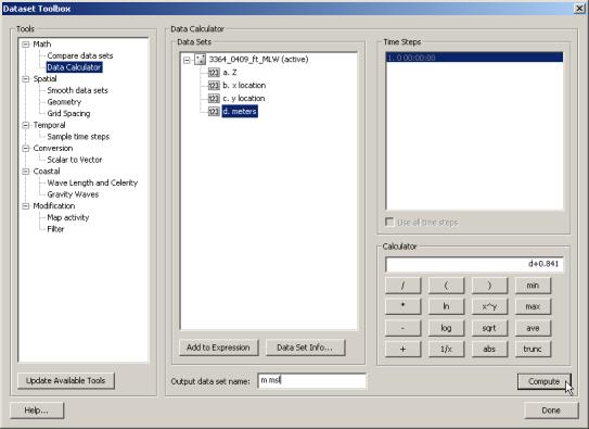
13 Dataset Calculator 13

 MLW MSL + 2.17 ft (0.")
14 NJ DEP Channel Surveys June 2009 Survey Provided conversion from local datum to NAVD88: XYZ pulled out of drawing and changed to ascii format MLW NAVD ft (0.735 m) MLW MSL ft (0.661 m) 14
 Vertical Datum: NAVD88 (m)")
15 Field Data Collection Multibeam Bay Bathymetry (August 2009) Horizontal Datum: State Plane NAD83 New Jersey 2900 (m) Vertical Datum: NAVD88 (m) 15
 Vertical Datum: NAVD88 (ft)")
16 LIDAR Files are ed in separate sections from the NOAA CSC Archive Typically several to 10s of files that are mb in size Compiling takes time Points have been sampled/filtered and cropped to area of interest Horizontal Datum: State Plane NAD83 New Jersey 2900 (ft) Vertical Datum: NAVD88 (ft) 16

")

")
17 Coastal Relief Model (DTM/DEM) Generate a 3 sec (pt/3 rd second) grid 17
 Not accurate for shallow bathymetry (used for")
18 Coastal Relief Model Horizontal Datum: Geographic NAD83 Vertical Datum: MSL (m) Not accurate for shallow bathymetry (used for offshore) 18
 Added extra bay contour (set to -0.")
19 Extra Bathymetry Convert shoreline shapefile in SMS Horizontal Datum: State Plane NAD83 New Jersey 2900 (ft) Added extra bay contour (set to m) 19
20 Convert a Shapefile to Map Drag and drop the shapefile (.shp) Highlight all Coastline Mapping Shapes Feature Objects Turn off GIS Data Arcs generated from GIS shapefile 20


 Modify as necessary")

21 Convert a Map to Scatter Highlight all Arcs Rt-Click Redistribute Vertices Specified Spacing (spacing in spatial coordinates) Feature Objects Map Scatter Include all feature points and vertices (vertices spacing was set to 10) Modify as necessary (i.e. remove entrance channel shoreline because it is old seawall and jetty configuration LIDAR used here) 21


22 Create a Contour Polyline in the Map Module Select Default Coverage under Map Data Type Generic Mapping/Observation/Shoals Draw arcs (polylines) feature with tool Select arcs and convert the z elevation to the desired contour elevation 22
 Feature Objects Map>Scatter Include Feature Pts and vertices and the Arc")
23 Create Scatterset Points from Map Data Select arcs to redistribute the spacing of vertices Feature Objects Redistribute Vertices Specify Spacing based on horizontal coordinate system units (metric in this case) Feature Objects Map>Scatter Include Feature Pts and vertices and the Arc Elevations 23


24 All Files Referenced to Same Horizontal and Vertical Datum Delete unnecessary data points (check alignment and elevations in overlapping datasets) 24


25 Merging Scattersets Merging all scattersets will integrate all points. Overlapping areas of scattersets should either be deleted, or use a separate method of merging (by prioritizing using triangles). Select the dataset 25
26 Surface-water Modeling System (SMS) Questions? Tanya Beck Or Mitch Brown
1. Working with Bathymetry
 1. Working with Bathymetry The CMS setup for Shark River Inlet provides a succinct example for illustrating a number of methods and SMS tools that can be applied to most engineering projects. The area
Appendix A Lower Columbia River Chart Datum Modeling
 Appendix A Lower Columbia River Chart Datum Modeling David Evans and Associates, Inc. David Evans and Associates, Inc. 2801 SE Columbia Way, Ste. 130 Vancouver, WA 98661 (360) 314-3200 1.0 Vertical Datum
Overview of Recent Tidal Projects in the United States
 1 st Tides and Water Levels Working Group Meeting Overview of Recent Tidal Projects in the United States Stephen Gill National Oceanic and Atmospheric Administration, National Ocean Service Center for
VDatum and SBET to Improve Accuracy of NOAA s High-Resolution Bathymetry
 VDatum and SBET to Improve Accuracy of NOAA s High-Resolution Bathymetry US HYDRO 2007 Extended Abstract Author: Crescent H. Moegling CoAuthor: Steve Brodet Moegling HYDRO 2007 1 Introduction NOAA s Hydrographic
VERTICAL DATUM TRANSFORMATIONS FOR KINEMATIC GPS HYDROGRAPHIC SURVEYS. Kurt W. Hess, Dennis G. Milbert, Stephen K. Gill, and Daniel R.
 VERTICAL DATUM TRANSFORMATIONS FOR KINEMATIC GPS HYDROGRAPHIC SURVEYS Kurt W. Hess, Dennis G. Milbert, Stephen K. Gill, and Daniel R. Roman National Ocean Service, NOAA ABSTRACT Kinematic Global Positioning
NATIONAL VDATUM -- THE IMPLEMENTATION OF A NATIONAL VERTICAL DATUM TRANSFORMATION DATABASE
 NATIONAL VDATUM -- THE IMPLEMENTATION OF A NATIONAL VERTICAL DATUM TRANSFORMATION DATABASE Bruce Parker, Dennis Milbert, Kurt Hess, and Stephen Gill National Ocean Service, NOAA The National Ocean Service
INTEGRATING BATHYMETRY, TOPOGRAPHY, AND SHORELINE, AND THE IMPORTANCE OF VERTICAL DATUMS
 INTEGRATING BATHYMETRY, TOPOGRAPHY, AND SHORELINE, AND THE IMPORTANCE OF VERTICAL DATUMS Bruce Parker, Dennis Milbert, Kurt Hess, and Stephen Gill National Ocean Service, NOAA 1315 East-West Highway Silver
Vertical Datum Conversions for Regional Coastal Management
 Vertical Datum Conversions for Regional Coastal Management Jennifer M. Wozencraft Joint Airborne Lidar Bathymetry Technical Center of Expertise US Army Engineer District Mobile 109 St. Joseph Street Mobile,
21st International Conference of The Coastal Society
 21st International Conference of The Coastal Society DEVELOPMENT OF A VERTICAL DATUM TRANSFORMATION TOOL AND A BATHYMETRIC/TOPOGRAPHIC DIGITAL ELEVATION MODEL FOR SOUTHERN CALIFORNIA Edward P. Myers, NOAA/NOS
Old House Channel Bathymetric and Side Scan Survey
 FIELD RESEARCH FACILITY DUCK, NC Old House Channel Bathymetric and Side Scan Survey COASTAL AND HYDRAULICS LABORATORY FIELD DATA COLLECTION AND ANALYSIS BRANCH Michael Forte December 2009 View looking
Determining Accurate Elevations: Datums & Tools, Today & Tomorrow
 Determining Accurate Elevations: Datums & Tools, Today & Tomorrow Association of State Floodplain Managers Annual Meeting Grand Rapids, MI Christine Gallagher June 21, 2016 Overview NGS Mission Important
Determining Accurate Elevations: Datums & Tools, Today & Tomorrow
 Determining Accurate Elevations: Datums & Tools, Today & Tomorrow Maryland Association Floodplain and Stormwater Managers Linthicum Heights, MD Christine Gallagher Oct. 20, 2016 Overview NGS Mission Important
Overview of Tides and Water Levels
 Overview of Tides and Water Levels www.tidesandcurrents.noaa.gov New Orleans, Baton Rouge, Lafayette, LA March 2009 Gerald Hovis, NOAA - National Ocean Service William Sweet, NOAA - National Ocean Service
Joining New Zealand Land and Sea Vertical Datums (JLAS) Graeme Blick Group Manager Positioning and Resilience
 Graeme Blick Group Manager Positioning and Resilience") Presented at the FIG Congress 2018, May 6-11, 2018 in Istanbul, Turkey Joining New Zealand Land and Sea Vertical Datums (JLAS) Graeme Blick Group Manager Positioning and Resilience Mapping NZ 2025 What
Presented at the FIG Congress 2018, May 6-11, 2018 in Istanbul, Turkey Joining New Zealand Land and Sea Vertical Datums (JLAS) Graeme Blick Group Manager Positioning and Resilience Mapping NZ 2025 What
Hydraulics and Floodplain Modeling Managing HEC-RAS Cross Sections
 WMS 10.1 Tutorial Hydraulics and Floodplain Modeling Managing HEC-RAS Cross Sections Modify cross sections in an HEC-RAS model to use surveyed cross section data v. 10.1 Objectives Build a basic HEC-RAS
Hydraulics and Floodplain Modeling Managing HEC-RAS Cross Sections
 v. 9.1 WMS 9.1 Tutorial Hydraulics and Floodplain Modeling Managing HEC-RAS Cross Sections Modify cross sections in an HEC-RAS model to use surveyed cross section data Objectives Build a basic HEC-RAS
The Chesapeake and Delaware Bays VDatum Development, and Progress Towards a National VDatum
 The Chesapeake and Delaware Bays VDatum Development, and Progress Towards a National VDatum Zhizhang Yang, NOAA s Coast Survey Development Laboratory, Silver Spring, MD Edward Myers, NOAA s Coast Survey
3. GENERAL TIDAL DATUM COMPUTATION PROCEDURES
 3. GENERAL TIDAL DATUM COMPUTATION PROCEDURES 3.1 Datum Computation Procedures Overview A vertical datum is termed a tidal datum when it is defined by a certain phase of the tide. Tidal datums are local
Cedar Bayou: Houston Ship Channel to U.S. Steel Dock
 Cedar Bayou: + + -.ft.ft + B A R B O U R S BC A + 2+ + 2+ + + 2 + 2 A + 2+ + + + + + + 'W 2 'N 'W 2 'N 2 2 2 2 2 2 2 2 2 2 2 + Cedar Bayou Channel Buoy 2 Light 2 + Cedar Bayou Channel Daybeacon 2+ Cedar
MLG to MLLW Vertical Datum Conversion. Mississippi River Venice, Louisiana to the Gulf of Mexico (Vicinity of Southwest Pass) Louisiana
 Louisiana") Engineering Documentation Report EDR-OD-01 MLG to MLLW Vertical Datum Conversion Mississippi River Venice, Louisiana to the Gulf of Mexico (Vicinity of Southwest Pass) Louisiana Prepared by: US Army Corps
Engineering Documentation Report EDR-OD-01 MLG to MLLW Vertical Datum Conversion Mississippi River Venice, Louisiana to the Gulf of Mexico (Vicinity of Southwest Pass) Louisiana Prepared by: US Army Corps
Course Instructions. 3 Easy Steps to Complete the Course: 1.) Read the Course PDF Below.
 Read the Course PDF Below.") Course Instructions NOTE: The following pages contain a preview of the final exam. This final exam is identical to the final exam that you will take online after you purchase the course. After you purchase
Course Instructions NOTE: The following pages contain a preview of the final exam. This final exam is identical to the final exam that you will take online after you purchase the course. After you purchase
U.S. Army Corps of Engineers: Review of Progress Toward Consistent Vertical Datums. by Jim Garster and Mark Huber
 U.S. Army Corps of Engineers: Review of Progress Toward Consistent Vertical Datums by Jim Garster and Mark Huber i ii Abstract A vertical datum is the most important part of any geospatial data, no matter
INGESTION OF JALBTCX ALB DATASET INTO NOAA'S CHART PRODUCTION
 INGESTION OF JALBTCX ALB DATASET INTO NOAA'S CHART PRODUCTION Shachak Pe eri (JHC/CCOM) and Gretchen Imahori (NOAA) OCS/MCD (NOAA): John Barber, Anthony Klemm, Julia Powell, Mike Brown and John Nyberg
United States - Canada Hydrographic Commission Halifax, Canada May 16, 2016
 United States - Canada Hydrographic Commission Halifax, Canada May 16, 2016 USCHC39 INF-E NOAA Pilot Study Applying Satellite-Derived Bathymetry to Longboat Pass, Florida Submitted by: The United States
Geodesy, Geographic Datums & Coordinate Systems
 Geodesy, Geographic Datums & Coordinate Systems What is the shape of the earth? Why is it relevant for GIS? 1/23/2018 2-1 From Conceptual to Pragmatic Dividing a sphere into a stack of pancakes (latitude)
Application of GPS heights to Bay of Fundy multibeam data
 GEOLOGICAL SURVEY OF CANADA OPEN FILE 6658 Application of GPS heights to Bay of Fundy multibeam data David W. Dodd 2010 GEOLOGICAL SURVEY OF CANADA OPEN FILE 6658 Application of GPS heights to Bay of Fundy
Final Report. Calculation of vertical tidal datums for the tidal Hudson River north of Yonkers, New York
 Final Report Calculation of vertical tidal datums for the tidal Hudson River north of Yonkers, New York Submitted to: Photo Science, Inc. and National Oceanic and Atmospheric Administration Coastal Services
MPA Baseline Program. Annual Progress Report
 MPA Baseline Program Annual Progress Report Principal Investigators please use this form to submit your MPA Baseline Program project annual report, including an update on activities completed over the
Houston Ship Channel: Lower End Morgans Point to Alexander Island
 + + + + + A + A ' ' + + + + + + BC + 5 + + A + + -.5ft.H O U S T O N + + 5 + + + 'N ' Cedar Bayou Channel Buoy Houston Ship Channel Light + + Reporting Point 5 ++ 'N Houston Ship Channel Light + ' > -
An NGS Illustrated Guide to Geodesy for GIS Professionals
 An NGS Illustrated Guide to Geodesy for GIS Professionals Michael Dennis, RLS, PE michael.dennis@noaa.gov Esri User Conference San Diego Convention Center July 14-18, 2014 San Diego, CA Why should we care
Tidal Datums & Coastal Profiles. DGGS Coastal Hazards Program - Fairbanks, AK Program Manager: Nicole Kinsman
 Tidal Datums & Coastal Profiles DGGS Coastal Hazards Program - Fairbanks, AK Program Manager: Nicole Kinsman nicole.kinsman@alaska.gov 907-451-5026 Overview AOOS-funded DGGS Projects: 1) Port Heiden Short-Term
Datums for a Dynamic Earth
 Datums for a Dynamic Earth Based on a paper given at the American Society of Agricultural and Biological Engineers (ASABE) Conference in Reno, Nevada June 2009 Rollin StrohmanPh.D. Tom Mastin L.S Background
Progress Towards Upgrading and. Integrating Vertical Datums in New
 Progress Towards Upgrading and Presented at the FIG Working Week 2017, Integrating Vertical Datums in New May 29 - June 2, 2017 in Helsinki, Finland Zealand Graeme Blick Chief Geodesist What we ll cover
Progress Towards the Seamless Combination of Bathymetric and Topographic Data in New Zealand
 Progress Towards the Seamless Combination of Bathymetric and Topographic Data in New Zealand Matt Amos Senior Technical Advisor National Geodetic Office Introduction Datasets usually defined in terms of
Assessing the Feasibility of Wind Power Production for the University of Rhode Island s Bay Campus
 University of Rhode Island DigitalCommons@URI Senior Honors Projects Honors Program at the University of Rhode Island 2009 Assessing the Feasibility of Wind Power Production for the University of Rhode
Minimum Drawing & Electronic Submittal Requirements For Record Drawings /As-Builts
 Minimum Drawing & Electronic Submittal Requirements For Record Drawings /As-Builts PUBLIC WORKS ENGINEERING DEPARTMENT Revised: February 1, 2017 MINIMUM DRAWING REQUIREMENTS A. GENERAL PLAN REQUIREMENTS:
Datums and Tools to Connect Geospatial Data Accurately
 Datums and Tools to Connect Geospatial Data Accurately Pamela Fromhertz Colorado State Geodetic Advisor National Geodetic Survey National Oceanic and Atmospheric Administration GIS-T April 18, 2012 Loveland,
COOK INLET NAVIGATION CHANNEL
 COOK INLET NAVIGATION CHANNEL 1-5 COOK INLET NAVIGATION CHANNEL, ALASKA (CWIS NO. 10324, 10534) Condition of Improvement 30 September 2011 AUTHORIZATION: (1) Water Resources Development Act of 1996 (Public
Helping Build Your Capacity in Nautical Charting & Hydrography
 Helping Build Your Capacity in Nautical Charting & Hydrography Helping Chart your World Rajesh Alla Riyadh, Kingdom of Saudi Arabia 04-06 March 2013 Company Background Marine Services Capacity Building
MAINTENANCE DREDGING, PORT OF ALASKA HYDROGRAPHIC SURVEY PRE_ _POA ANCHORAGE, ALASKA V-101 SHEET IDENTIFICATION.
 _FINAL.DWG /7/08 0:07 AM " = 00' 0-8 W9KB8C000 ANCEXP 7 May 08 /07/8 CONTRACT NO. W9KB-8-C-000 Engineers V-0 _FINAL.DWG /7/08 0:07 AM " = 00' 0-8 W9KB8C000 ANCEXP 7 May 08 /07/8 CONTRACT NO. W9KB-8-C-000
Development of Mosaic Datasets and Image Services for Bathymetric Data
 Development of Mosaic Datasets and Image Services for Bathymetric Data Jesse Varner Cooperative Institute for Research in Environmental Sciences (CIRES), University of Colorado John Cartwright NOAA National
Philadelphia District: Cape May County, New Jersey
 ERDC/RSM-DB6, June 2003 Regional Sediment Management (RSM) Demonstration Program Project Brief Philadelphia District: Cape May County, New Jersey ISSUE The Atlantic coast of New Jersey extends from Sandy
TABLE OF CONTENTS. Executive Summary 1 Acknowledgements 3 Introduction 3 Storm Recovery and Beach Project Effectiveness 3
 TABLE OF CONTENTS Executive Summary 1 Acknowledgements 3 Introduction 3 Storm Recovery and Beach Project Effectiveness 3 Monmouth County 4 Figures 1a-1d. Monmouth County Station Locations 5 Site Descriptions
The Normal Baseline. Dick Gent Law of the Sea Division UK Hydrographic Office
 The Normal Baseline Dick Gent Law of the Sea Division UK Hydrographic Office 2 The normal baseline for measuring the breadth of the territorial sea is the low water line along the coast as marked on large
- go over homework #2 on applications - Finish Applications Day #3 - more applications... tide problems, start project
 10/20/15 ALICATIONS DAY #3 HOMEWORK TC2 WARM U! Agenda Homework - go over homework #2 on applications - Finish Applications Day #3 - more applications... tide problems, start project UCOMING: OW #6 Quiz
CHAPTER 5 Vertical Control. CE 316 January 2012
 CHAPTER 5 Vertical Control CE 316 January 01 137 5.1 Introduction Vertical Datums Leveling Techniques and Corrections Bench Mark Design and Construction Bench Mark Data Trigonometric Barometric Leveling
v Introduction Images Import images in a variety of formats and register the images to a coordinate projection WMS Tutorials Time minutes
 v. 10.1 WMS 10.1 Tutorial Import images in a variety of formats and register the images to a coordinate projection Objectives Import various types of image files from different sources. Learn how to work
Monitoring of Mosul Reservoir Using Remote Sensing Techniques For the Period After ISIS Attack in 9 June Muthanna Mohammed Abdulhameed AL Bayati
 For the Period After ISIS Attack in 9 June 2014 Lecture: University of Technology Baghdad- Building and Construction Dept 1- Introduction The Mosul Dam is the fourth largest dam in the Middle East,(1)established
State of New Jersey Chris Christie, Governor. Dept. of Environmental Protection Bob Martin, Commissioner
 Cape May Beach 2016/2017 Renourishment Cape May Inlet to Lower Township & Lower Cape May Meadows Cape May Point Cape May County, New Jersey New Jersey Department of Environmental Protection Engineering
BATHYMETRIC DATA AND NAUTICAL CHART DATUMS
 Distr. LIMITED ECA/NRD/CART.9/USA.2 October 1996 Original: ENGLISH Ninth United Nations Regional Cartographic Conference for Africa Addis Ababa, Ethiopia 11-15 November 1996 A GLOBAL APPROACH TO UPDATE
CHAPTER 11 SURVEY CADD
 CHAPTER 11 SURVEY CADD Chapter Contents Sec. 11.01 Sec. 11.02 Sec. 11.03 Sec. 11.04 Sec. 11.05 Sec. 11.06 Sec. 11.07 Sec. 11.08 Sec. 11.09 Sec. 11.10 General Description of Survey File Contents of Survey
Figure 1. Overview of Critical and Emerging Critical Areas along Columbia River
 GPS Derived Water Levels for Large Scale Hydrographic Surveys: Implementation of a Separation Model of the Columbia River Datum, A Case Study Crescent H. Moegling 1, Jon L. Dasler 2, Jason C. Creech 3,
Lecture # 7 Coordinate systems and georeferencing
 Lecture # 7 Coordinate systems and georeferencing Coordinate Systems Coordinate reference on a plane Coordinate reference on a sphere Coordinate reference on a plane Coordinates are a convenient way of
Survey Requirements. Design Guidelines and Standards. June Office of the University Architect
 Design Guidelines and Standards Survey Requirements June 2004 Office of the University Architect Construction Management P.O. Box 210181 Cincinnati, Ohio 45221-0181 Table of Contents Survey Requirements
Southeast O ahu (SEO) Regional Sediment Management (RSM) Workshop #2 June 1, 2005 Ko olau Golf Course
 Regional Sediment Management (RSM) Workshop #2 June 1, 2005 Ko olau Golf Course") Southeast O ahu (SEO) Regional Sediment Management (RSM) Workshop #2 June 1, 2005 Ko olau Golf Course 1 June 2005 Southeast O ahu RSM Workshop #2 1 Agenda Welcome and Introductions Mr. Sam Lemmo Summary
Southeast O ahu (SEO) Regional Sediment Management (RSM) Workshop #2 June 1, 2005 Ko olau Golf Course 1 June 2005 Southeast O ahu RSM Workshop #2 1 Agenda Welcome and Introductions Mr. Sam Lemmo Summary
Beach monitoring with GPS William F Price Department of Civil Engineering, University of Brighton, BRIGHTON, BN1 4GJ, UK
 Beach monitoring with GPS William F Price Department of Civil Engineering, University of Brighton, BRIGHTON, BN1 4GJ, UK Abstract In common with many other countries that have an extended coastline, sea
Objectives Learn how to import and display shapefiles with and without ArcObjects. Learn how to convert the shapefiles to GMS feature objects.
 v. 10.1 GMS 10.1 Tutorial Importing, displaying, and converting shapefiles Objectives Learn how to import and display shapefiles with and without ArcObjects. Learn how to convert the shapefiles to GMS
Handling Interferometric Data: Streamlining the Processing Flow
 Handling Interferometric Data: Streamlining the Processing Flow Paper 5 at Hydro8, 4 th November 2008 Tom Hiller, Advanced Products Manager, GeoAcoustics Ltd. WORLD CLASS through people, technology and
ELEMENTS OF THE NATIONAL SPATIAL REFERENCE SYSTEM
 Dave Doyle NGS Chief Geodetic Surveyor dave.doyle@noaa.gov 301-713-3178 ELEMENTS OF THE NATIONAL SPATIAL REFERENCE SYSTEM ESRI SURVEY SUMMIT San Diego, CA June 17, 2007 ftp://ftp.ngs.noaa.gov/dist/daved/esri
NJDEP GPS Data Collection Standards for GIS Data Development
 NJDEP GPS Data Collection Standards for GIS Data Development Bureau of Geographic Information Systems Office of Information Resource Management April 24 th, 2017 Table of Contents 1.0 Introduction... 3
A UNIFORM TIDAL DATUM SYSTEM FOR THE UNITED STATES OF AM ERICA
 A UNIFORM TIDAL DATUM SYSTEM FOR THE UNITED STATES OF AM ERICA by R. Lawrence SWANSON Environmental Research Laboratories National Oceanic and Atm ospheric Adm inistration and Carroll I. TH U RLOW National
SURVEYING I CENG 383
 SURVEYING I CENG 383 9/21/2011 2 Introduction Definition An art of collecting data for mapping the relative positions of points above, below or on the surface of the earth. Surveying also includes the
2012 STATUS REPORT NJ BEACHES AND INLETS PHILADELPHIA DISTRICT, USACE
 2012 STATUS REPORT NJ BEACHES AND INLETS PHILADELPHIA DISTRICT, USACE Jeff Gebert, Coastal Planning, USACE Philadelphia Philadelphia District Established 1866 Delaware River Basin Parts of 5 states 9 million
Traffic and Roadway Improvements - Rte 123 (Belmont Street) Brockton, MA Client: BETA Group, Inc.
 Brockton, MA Client: BETA Group, Inc.") HIGHWAY PROJECT EXPERIENCE Traffic and Roadway Improvements - Rte 123 (Belmont Street) Brockton, MA Client: BETA Group, Inc. Alpha provided survey services to prepare a base plan of an approximately 2900
HIGHWAY PROJECT EXPERIENCE Traffic and Roadway Improvements - Rte 123 (Belmont Street) Brockton, MA Client: BETA Group, Inc. Alpha provided survey services to prepare a base plan of an approximately 2900
DetailedShoreChange at Chesapeake BayDune Systems. C.S.Hardaway,Jr. D.A.Milligan K.Farnsworth S. Dewing
 DetailedShoreChange at Chesapeake BayDune Systems C.S.Hardaway,Jr. D.A.Milligan K.Farnsworth S. Dewing November 2001 Detailed Shore Change at Chesapeake Bay Dune Systems by C. S. Hardaway, Jr. D. A. Milligan
NPS Inventory and Monitoring Program
 NPS Inventory and Monitoring Program Metrics and Protocols Monitoring Tidal Marsh Condition Tidal Marsh Resiliency Coordination Workshop U.S. Fish & Wildlife Service, Hadley, MA Dec 8-9, 2014 Northeast
Lecture 1 Introduction to Remote Sensing
 Lecture 1 Introduction to Remote Sensing Dr Ian Leiper School of Environmental and Life Sciences Bldg Purple 12.2.27 1 2 Lecture Outline Introductions Unit admin Learning outcomes Unit outline Practicals
Objectives Learn how to import and display shapefiles in GMS. Learn how to convert the shapefiles to GMS feature objects. Required Components
 v. 10.3 GMS 10.3 Tutorial Importing, displaying, and converting shapefiles Objectives Learn how to import and display shapefiles in GMS. Learn how to convert the shapefiles to GMS feature objects. Prerequisite
Overview of New Datums NOAA s National Geodetic Survey
 Overview of New Datums NOAA s National Geodetic Survey February 3, 2015 1 NGS s Mission and Role NGS Mission: To define, maintain, and provide access to the National Spatial Reference System to meet our
NOAA s National Ocean Service / Office of Coast Survey
 Coast Survey OCS 1807 2007 Maintains over 1000 nautical charts & 9 Coast Pilots Surveys over 3.4M SNM of oceans and lakes Conducts research and development in hydrography Thomas Jefferson Founder of The
MPA Baseline Program. Annual Progress Report
 MPA Baseline Program Annual Progress Report Principal Investigators - please use this form to submit your MPA Baseline Program project annual report, including an update on activities completed over the
v WMS 10.0 Tutorial Introduction Images Read images in a variety of formats and register the images to a coordinate projection
 v. 10.0 WMS 10.0 Tutorial Read images in a variety of formats and register the images to a coordinate projection Objectives Read various types of image files from different sources. Learn how to work with
GIS Module GMS 7.0 TUTORIALS. 1 Introduction. 1.1 Contents
 GMS 7.0 TUTORIALS 1 Introduction The GIS module can be used to display data from a GIS database directly in GMS without having to convert that data to GMS data types. Native GMS data such as grids and
GLMTF November 18, 2014 Presentation
 GLMTF November 18, 2014 Presentation Michigan Security Network Founded by major corporations, industry leaders and leading universities in 2008 as a non-profit organization (501c6). MiSN mission is to
Hydrographic processing considerations in the Big Data age: An overview of technology trends in ocean and coastal surveys
 IOP Conference Series: Earth and Environmental Science PAPER OPEN ACCESS Hydrographic processing considerations in the Big Data age: An overview of technology trends in ocean and coastal surveys To cite
v. 8.0 GMS 8.0 Tutorial GIS Module Shapefile import, display, and conversion Prerequisite Tutorials None Time minutes
 v. 8.0 GMS 8.0 Tutorial Shapefile import, display, and conversion Objectives Learn how to import and display shapefiles with and without ArcObjects. Convert the shapefiles to GMS feature objects. Prerequisite
Los Angeles County Coastal Hazard Modeling and Vulnerability Assessment
 Los Angeles County Coastal Hazard Modeling and Vulnerability Assessment Technical Methods Report Prepared for December 23, 2016 City of Santa Monica TABLE OF CONTENTS 1. Introduction 6 1.1 Purpose 6 1.2
BUILDING A SINGLE VERSION OF TRUTH
 BUILDING A SINGLE VERSION OF TRUTH Versioning in PPDM Tarun Chandrasekhar Director, Data Management Products Neuralog AGENDA Introductions Importance of Source Need for multiple sources Source Prioritization
1. Qualitative Assessment... II-101
 Table of Contents I. Introduction... I-1 A. Session Law 2009-479 / House Bill 709... I-2 B. Public Consultation... I-3 C. Selection of Study Sites... I-5 D. Limitations of Study... I-8 II. Physical Assessment...
Total Marks : 100 READ THE FOLLOWING DIRECTIONS CAREFULLY:
 Mathematics Writing Time : 2 Hours Total Marks : 100 READ THE FOLLOWING DIRECTIONS CAREFULLY: 1. Do not write in the first fifteen minutes. This time is to be spent on reading the questions. After having
SonarWiz Datum Align Reference
 SonarWiz Datum Align Reference Rev 8.0, 12/22/2015 Chesapeake Technology, Inc. email: support@chesapeaketech.com Main Web site: http://www.chesapeaketech.com Support Web site: http://www.chestech-support.com
Application of an Artificial Neural Network to Predict Tidal Currents in an Inlet
 Application of an Artificial Neural Network to Predict Tidal Currents in an Inlet by Wenrui Huang and Catherine Murray PURPOSE: The Coastal and Hydraulics Engineering Technical Note (CHETN) herein describes
Filter1D Time Series Analysis Tool
 Filter1D Time Series Analysis Tool Introduction Preprocessing and quality control of input time series for surface water flow and sediment transport numerical models are key steps in setting up the simulations
Vertical Control via GPS vs. Tide Gauges: A Pilot Study
 Vertical Control via GPS vs. Tide Gauges: A Pilot Study Rebecca Quintal, John Shannon Byrne, John Kiernan, Evan Robertson, Walter Simmons, Gary Davis, Paul Donaldson, Deborah Smith, Jason Infantino and
MARINE PRIVATE MOORAGE APPLICATION REQUIREMENTS; EXAMPLE PLANS
 MARINE PRIVATE MOORAGE APPLICATION REQUIREMENTS; EXAMPLE PLANS 1) SMALL SCALE GENERAL SITE PLAN A : The purpose of this map is to indicate the location of the application in relation to surveyed parcels
Orthoimagery Standards. Chatham County, Georgia. Jason Lee and Noel Perkins
 1 Orthoimagery Standards Chatham County, Georgia Jason Lee and Noel Perkins 2 Table of Contents Introduction... 1 Objective... 1.1 Data Description... 2 Spatial and Temporal Environments... 3 Spatial Extent
Geodetic Positioning Refresher
 Geodetic Positioning Refresher by Joan Yau PhD ABCLS AGM 2016, Kimberley BC Contents Horizontal / Vertical Datums and Epochs used in BC and Canada How do we reference our project coordinates to BC datums
The Passive Aquatic Listener (PAL): An Adaptive Sampling Passive Acoustic Recorder
: An Adaptive Sampling Passive Acoustic Recorder") The Passive Aquatic Listener (PAL): An Adaptive Sampling Passive Acoustic Recorder Jennifer L. Miksis Olds Applied Research Laboratory, The Pennsylvania State University Jeffrey A. Nystuen Applied Physics
The Passive Aquatic Listener (PAL): An Adaptive Sampling Passive Acoustic Recorder Jennifer L. Miksis Olds Applied Research Laboratory, The Pennsylvania State University Jeffrey A. Nystuen Applied Physics
New Jersey Regional Sediment Management
 New Jersey Regional Sediment Management RSM Demo: Cape May Inlet / Wildwood Sand Bypassing Project Ocean County N Atlantic Ocean Atlantic County Delaware Bay Cape May County 8 0 8 16 Miles Regional Sediment
Basic Geodetics. Bobby Saleh Guidon Energy April 13, 2017
 Experts in Geomatics, Surveying, Positioning, Geospatial Data, and Mapping Sciences Basic Geodetics Bobby Saleh Guidon Energy b.saleh@guidonenergy.com April 13, 2017 The Earth is NOT flat Q: So what does
GPS Pathfinder Office Software or the GPS Analyst Extension for ESRI ArcGIS Software: Resolving the NAD 83 Datum Transformation Issue
 Mapping & GIS Support Note 5 May 2005 GPS Pathfinder Office Software or the GPS Analyst Extension for ESRI ArcGIS Software: Resolving the NAD 83 Datum Transformation Issue Summary The current realizations
Charleston Harbor Ship Motion Data Collection and Squat Analysis
 Charleston Harbor Ship Motion Data Collection and Squat Analysis by Michael J. Briggs, Stephen T. Maynord, Charles R. Nickles, and Terry N. Waller PURPOSE: This Coastal and Hydraulics Engineering Technical
Using the ADMS Mapper
 Using the ADMS Mapper Mark Attree, CERC ADMS-Urban and ADMS-Roads User Group Meeting 14 th November 2013 Newcastle Contents Introduction Key applications Using the ADMS Mapper Viewing model input Checking
Aerial photography: Principles. Frame capture sensors: Analog film and digital cameras
 Aerial photography: Principles Frame capture sensors: Analog film and digital cameras Overview Introduction Frame vs scanning sensors Cameras (film and digital) Photogrammetry Orthophotos Air photos are
CanImage. (Landsat 7 Orthoimages at the 1: Scale) Standards and Specifications Edition 1.0
 Standards and Specifications Edition 1.0") CanImage (Landsat 7 Orthoimages at the 1:50 000 Scale) Standards and Specifications Edition 1.0 Centre for Topographic Information Customer Support Group 2144 King Street West, Suite 010 Sherbrooke, QC
CanImage (Landsat 7 Orthoimages at the 1:50 000 Scale) Standards and Specifications Edition 1.0 Centre for Topographic Information Customer Support Group 2144 King Street West, Suite 010 Sherbrooke, QC
Benefits and Impacts to Nautical Charting by Adopting a New Reference Frame. Dr. Neil Weston Office of Coast Survey, NOAA
 Benefits and Impacts to Nautical Charting by Adopting a New Reference Frame Dr. Neil Weston Office of Coast Survey, NOAA Motivation for this study NOAA s National Geodetic Survey New geometric reference
Development of Geoid Based Vertical Datums, A New Zealand Perspective
 Technical Seminar Reference Frame in Practice, Development of Geoid Based Vertical Datums, A New Zealand Perspective Matt Amos Manager Positioning and Innovation Land Information New Zealand Sponsors:
Converting a solid to a sheet metal part tutorial
 Converting a solid to a sheet metal part tutorial Introduction Sometimes it is easier to start with a solid and convert it to create a sheet metal part. This tutorial will guide you through the process
Physics 253 Fundamental Physics Mechanic, September 9, Lab #2 Plotting with Excel: The Air Slide
 1 NORTHERN ILLINOIS UNIVERSITY PHYSICS DEPARTMENT Physics 253 Fundamental Physics Mechanic, September 9, 2010 Lab #2 Plotting with Excel: The Air Slide Lab Write-up Due: Thurs., September 16, 2010 Place
Introduction to ANSYS DesignModeler
 Lecture 4 Planes and Sketches 14. 5 Release Introduction to ANSYS DesignModeler 2012 ANSYS, Inc. November 20, 2012 1 Release 14.5 Preprocessing Workflow Geometry Creation OR Geometry Import Geometry Operations