Old House Channel Bathymetric and Side Scan Survey
|
|
|
- Victor Perkins
- 5 years ago
- Views:
Transcription


1 FIELD RESEARCH FACILITY DUCK, NC Old House Channel Bathymetric and Side Scan Survey COASTAL AND HYDRAULICS LABORATORY FIELD DATA COLLECTION AND ANALYSIS BRANCH Michael Forte December 2009 View looking over the antennas of the motion and bathymetry sensor, south towards Old House Channel, Pamlico Sound, North Carolina.
2 Table of Contents Sections Page 1. Introduction 3 2. Methods.5 3. Data Processing.6 4. Results and Conclusions Appendix A..11 Figures and Tables Figure 1..4 Figure 2.6 Figure 3.7 Figure 4.8 Figure 5.9 Table
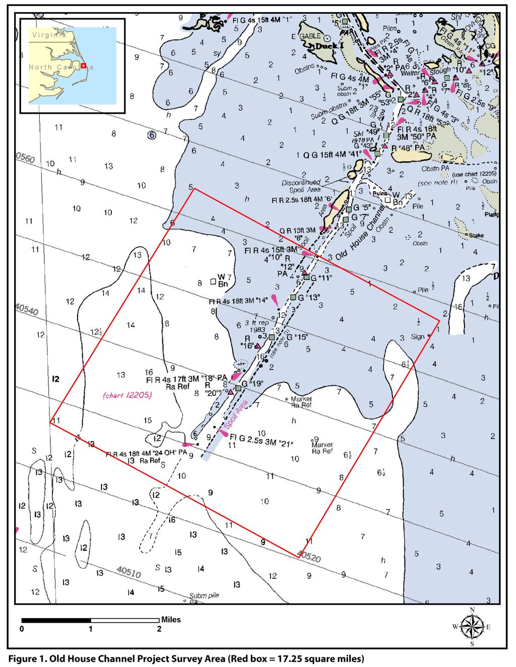
3 1. Introduction The U.S. Army Corps of Engineers Wilmington District and the State of North Carolina are partnering to develop a Beneficial Use of Dredged Material project. The project would address operational dredging needs for the Old House Channel portion of the Manteo, Shallowbag Bay project (Figure 1). This proposal would also address oyster reef restoration needs in North Carolina s Pamlico Sound, part of the Albemarle-Pamlico National Estuary. The Manteo Shallow Bag Bay Old House Channel Project would use sandy material dredged from Old House Channel to build submerged shoals to be topped with cultch for oyster reefs. Accurate bathymetry and mapping of the existing submerged aquatic vegetation (SAV) was required for assisting in the design of this project. 3
4 4
5 2. Methods The U.S. Army Corps of Engineers Field Research Facility (USACE FRF) used a 26-ft pontoon boat that is capable of surveying in water as shallow as ~0.5 ft. A Real-Time Kinematic Global Positioning Satellite (RTK-GPS) system was used to correct incoming satellite information at a known location (Base-Station) and then transmit the corrections in real time to the vessel via radio transmission (Figure 2). RTK-GPS error range is typically less than 3 inches in the x, y, and z planes. Depth soundings were directly referenced to the North American Vertical Datum of 1988 (NAVD88) and any variations in the water level surface during the survey had no impact. NAVD88 is approximately 0.66 ft above Mean Lower Low Water (MLLW) at the National Oceanic & Atmospheric Administration s Tidal Station ( ) Oregon Inlet Marina, Pamlico Sound, NC. A control monument was established and surveyed in at U.S. Coast Guard Facility Oregon Inlet. The station served as the reference (GPS Base Station) for the entire survey region. The control station provided a clear line of sight between the base station and the vessel. Accuracy checks were performed daily throughout the survey on surrounding NGS survey monuments to verify the position data. The accuracy checks did not exceed (+/- 2.5 inches) during the entire survey. The pontoon boat was outfitted with Geo-Acoustics GeoSwath Phase measuring bathymetry system which measures both bathymetry and seabed acoustic backscatter from a hull mounted transducer, providing co-registered depth soundings and side scan sonar information in water depths ranging from 1.5 to 300ft. An Applanix Position & Orientation for Marine Vessels (POSMV ) inertial measurement unit was used to record vessel motion and heading. An Ocean Sensors conductivity, temperature, density (CTD) sensor was used to measure the speed of sound through the water column (Figure 2) in order to adjust the Geoswath data for water temperature and density. Hypack survey software was used to navigate the boat along 132 preprogrammed survey lines and to log the position data. During the survey, which began on 18 June and was completed on 14 September 2009, approximately 480 miles of data were recorded. Although the survey spanned nearly 4 months only 16 field days were necessary to complete the field data collection. Windy conditions creating choppy seas, and summertime thunderstorms were the cause of many down days. Having a vessel that could operate in very shallow waters (~0.5ft) and be seaworthy posed a challenge for this field survey region. 5

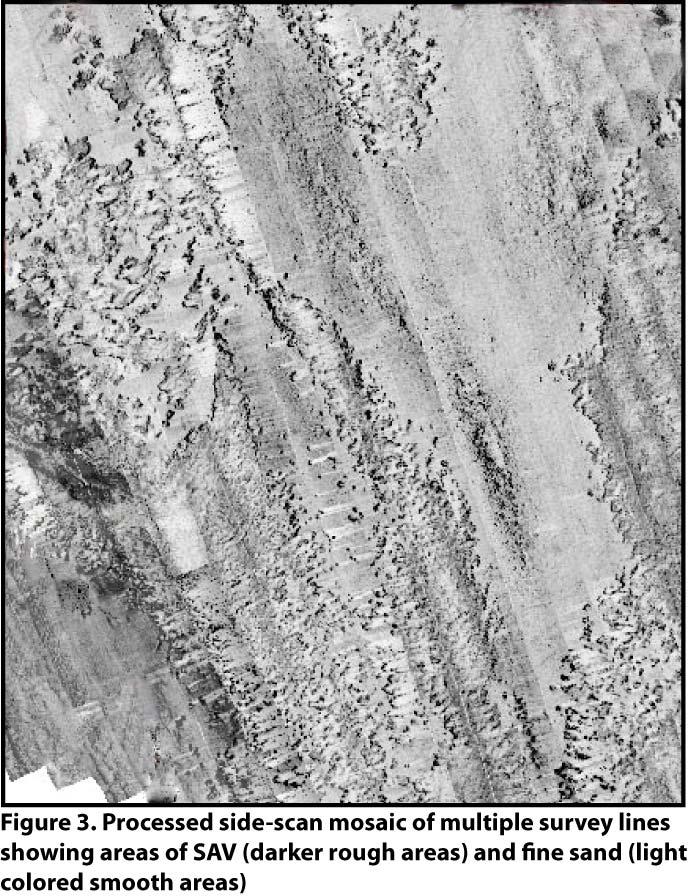
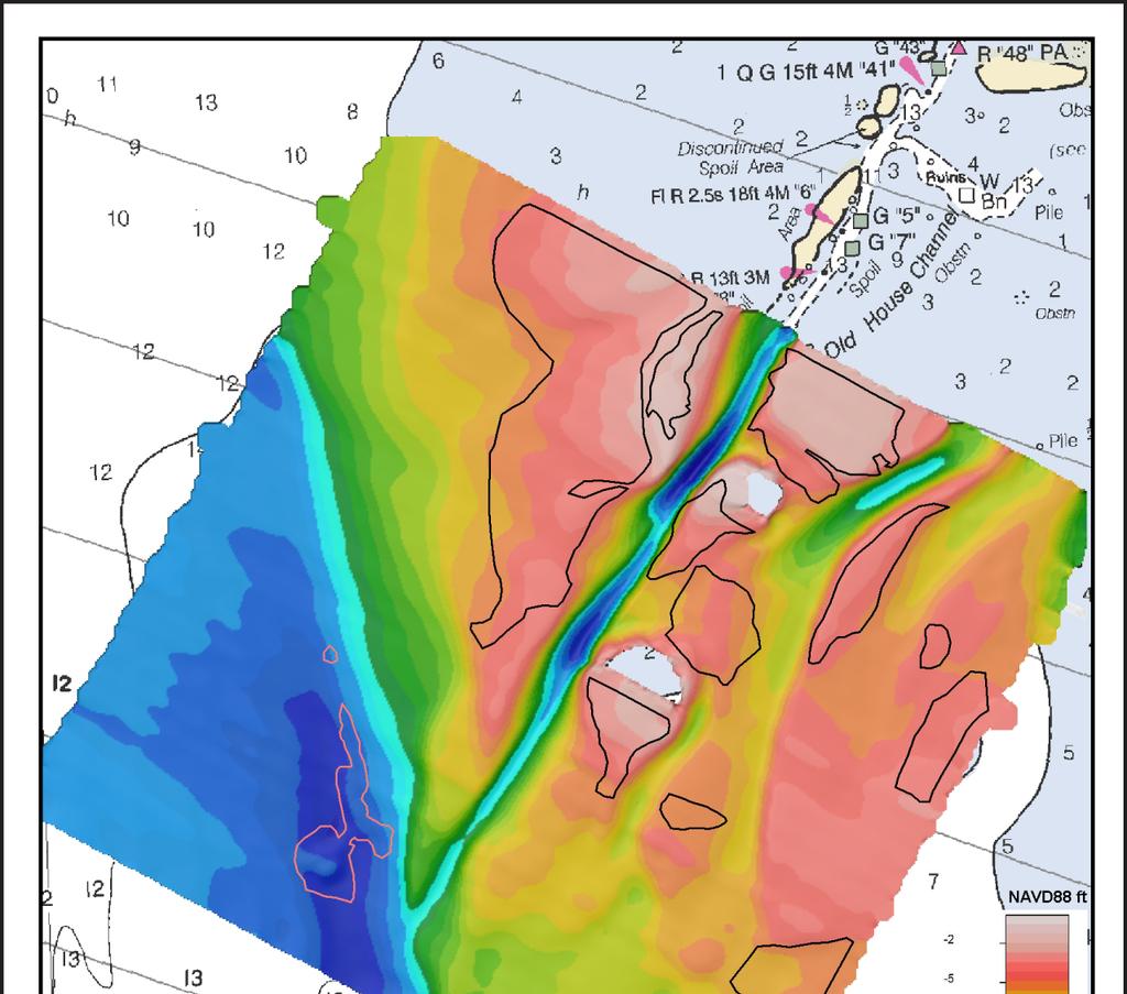
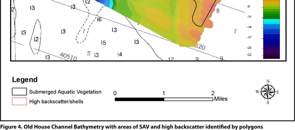
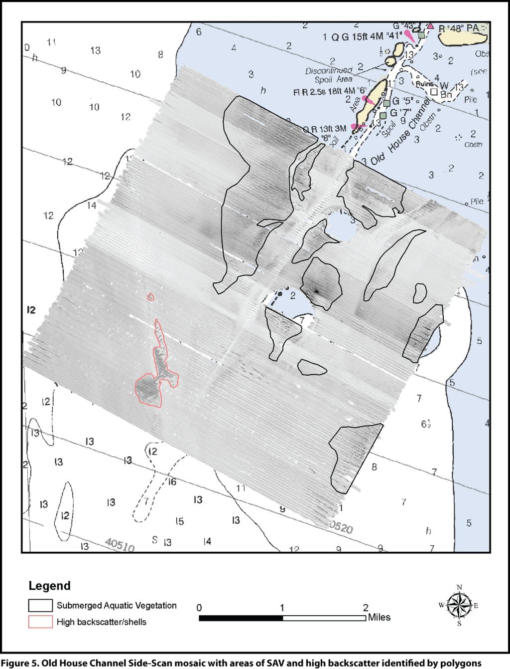
6 3. Data Processing The GeoSwath data were processed using Geo-Acoustics Geo-Swath Plus software that combines the GeoSwath, motion, and positioning data. The software corrects for errors associated with speed of sound and vessel motion, then incorporates these into the depth measurements. The resulting depths are relative to NAVD88, which can be related to MLLW level in Pamlico Sound. Processed swath sonar files were then gridded within Geo-Swath Plus using the weighted mean gridding algorithm, which computes depths in a regularly spaced ft rectilinear grid. These data were then imported into IVS 3-D Fledermaus using a natural neighbor weighted gridding algorithm which yielded the final position and depth data. The side-scan data were processed using Geo-Acoustics Geo-Texture software to remove the effects of things other than seabed material from the image, thus improving the interpretability of the texture information in the image. Swath files were imported into the software at a resolution of 2.5 ft and a series of process steps were applied. These processes included: seabed locate, filter bathymetry, trace normalization, and finally a slant range correction to remove the nadir and the water column effects. Figure 3 is a close-up detail of processed side-scan data. Swaths from individual days were merged to create a mosaic of the entire survey area. The mosaic was then exported out of the software as a geo-referenced jpeg for analysis in GIS. Figure 4 shows the bathymetry and Figure 5, the side-scan mosaic. 6
7 7
8 8
9 9
10 4. Results and Conclusions Table 1 shows bottom type and percent coverage found throughout the survey area. Approximately 2.25 square miles of SAV (13 percent) were identified and marked by color coded polygons in GIS (Figure 5, black polygons). The SAV produced a distinct signature on the sidescan record and was easily identified during analysis. In certain areas during the survey, the hydrographer could see the top of the grasses at the water surface, thus confirming that the sidescan return was detecting SAV. There appears to be a correlation between depth and SAV as displayed in Figure 4. SAV is generally found in depths less than 6 ft. SAV growth is often light limited and thus correlates with water depth. There was an estimated 0.19 square miles (1 percent) of high-backscatter area that likely contains oyster shells or coarse sediment material (Figure 5, pink polygons). These areas were found in deeper water (14 to 17ft). The majority (86 percent) of the survey area had a uniform bottom composed primarily of fine sands, which has a low backscatter due to signal absorbance. These areas are the more uniform light colored regions in Figure 5.. Table 1. Bottom Type And Coverage Percentage Material Type Area (sq mi) Coverage (%) SAV High backscatter/shells Fine Sand Project area
11 Appendix A (Deliverables) The survey data are referenced to the North American Datum of 1983 (NAD83) State Plane North Carolina Zone 3200 with units of survey feet. Depths are referenced to NAVD88 with units of survey feet. A Federal Geographic Data Committee approved metadata file has been created for the survey, which documents the geodetic parameters of the survey and provides a reference for the data. The report and data files have been uploaded to the following ftp site. ftp:// /saw/ohc_2009. A list of the final files on the ftp site is provided below. For more information regarding this project or to provide comments or recommendations, contact Mr. Michael Forte, Research Physical Scientist, at , ext. 228, or by Michael.f.forte@usace.army.mil. Final Files 1. OHC_2009_ss_mosaics.zip Old House Channel side scan mosaic geo-referenced jpegs at high (1200dpi) and low (300dpi) resolutions. 2. OHC_2009_NAD83sp_NAVD88_feet.shp.zip ESRI shape file of Old House Channel Bathymetry point data at the 15ft resolution 3. OHC_2009_shape_files ESRI shape file polygons of Old House Channel SAV and high backscatter areas. 4. OHC_2009_report.pdf Written survey report describing acquisition methodology, data processing techniques, and results. 5. OHC_2009_metadata.met Old House Channel metadata file 6. SAV_sidescan.jpg image of sidescan mosaic with areas of SAV and high backscatter identified by polygons 7. SAV_bathy.jpg image of bathymetry data with areas of SAV and high backscatter identified by polygons 11
Handling Interferometric Data: Streamlining the Processing Flow
 Handling Interferometric Data: Streamlining the Processing Flow Paper 5 at Hydro8, 4 th November 2008 Tom Hiller, Advanced Products Manager, GeoAcoustics Ltd. WORLD CLASS through people, technology and
VDatum and SBET to Improve Accuracy of NOAA s High-Resolution Bathymetry
 VDatum and SBET to Improve Accuracy of NOAA s High-Resolution Bathymetry US HYDRO 2007 Extended Abstract Author: Crescent H. Moegling CoAuthor: Steve Brodet Moegling HYDRO 2007 1 Introduction NOAA s Hydrographic
Seafloor Mapping Using Interferometric Sonars: Advances in Technology and Techniques
 Seafloor Mapping Using Interferometric Sonars: Advances in Technology and Techniques Tom Hiller, Advanced Products Manager, GeoAcoustics Ltd. WORLD CLASS through people, technology and dedication Brest,
Appendix A Lower Columbia River Chart Datum Modeling
 Appendix A Lower Columbia River Chart Datum Modeling David Evans and Associates, Inc. David Evans and Associates, Inc. 2801 SE Columbia Way, Ste. 130 Vancouver, WA 98661 (360) 314-3200 1.0 Vertical Datum
United States - Canada Hydrographic Commission Halifax, Canada May 16, 2016
 United States - Canada Hydrographic Commission Halifax, Canada May 16, 2016 USCHC39 INF-E NOAA Pilot Study Applying Satellite-Derived Bathymetry to Longboat Pass, Florida Submitted by: The United States
Instruction with Hands-on Practice: Creating a Bathymetric Database & Datum Conversion
 Instruction with Hands-on Practice: Creating a Bathymetric Database & Datum Conversion Tanya Beck Coastal and Hydraulics Laboratory Engineer Research and Development Center May 17, 2010 US Army Corps of
Lake Borgne, Louisiana Debris Mapping
 Lake Borgne, Louisiana Debris Mapping Abstract Gary R. Davis, Paul L. Donaldson, Walter Simmons, Rebecca Quintal Science Applications International Corporation 221 Third Street Newport, RI 02840 USA Under
MAINTENANCE DREDGING, PORT OF ALASKA HYDROGRAPHIC SURVEY PRE_ _POA ANCHORAGE, ALASKA V-101 SHEET IDENTIFICATION.
 _FINAL.DWG /7/08 0:07 AM " = 00' 0-8 W9KB8C000 ANCEXP 7 May 08 /07/8 CONTRACT NO. W9KB-8-C-000 Engineers V-0 _FINAL.DWG /7/08 0:07 AM " = 00' 0-8 W9KB8C000 ANCEXP 7 May 08 /07/8 CONTRACT NO. W9KB-8-C-000
Three-dimensional investigation of buried structures with multi-transducer parametric sub-bottom profiler as part of hydrographical applications
 Three-dimensional investigation of buried structures with multi-transducer parametric sub-bottom profiler as part Jens LOWAG, Germany, Dr. Jens WUNDERLICH, Germany, Peter HUEMBS, Germany Key words: parametric,
Overview of Recent Tidal Projects in the United States
 1 st Tides and Water Levels Working Group Meeting Overview of Recent Tidal Projects in the United States Stephen Gill National Oceanic and Atmospheric Administration, National Ocean Service Center for
Vertical Datum Conversions for Regional Coastal Management
 Vertical Datum Conversions for Regional Coastal Management Jennifer M. Wozencraft Joint Airborne Lidar Bathymetry Technical Center of Expertise US Army Engineer District Mobile 109 St. Joseph Street Mobile,
INGESTION OF JALBTCX ALB DATASET INTO NOAA'S CHART PRODUCTION
 INGESTION OF JALBTCX ALB DATASET INTO NOAA'S CHART PRODUCTION Shachak Pe eri (JHC/CCOM) and Gretchen Imahori (NOAA) OCS/MCD (NOAA): John Barber, Anthony Klemm, Julia Powell, Mike Brown and John Nyberg
Figure 1. Overview of Critical and Emerging Critical Areas along Columbia River
 GPS Derived Water Levels for Large Scale Hydrographic Surveys: Implementation of a Separation Model of the Columbia River Datum, A Case Study Crescent H. Moegling 1, Jon L. Dasler 2, Jason C. Creech 3,
Cedar Bayou: Houston Ship Channel to U.S. Steel Dock
 Cedar Bayou: + + -.ft.ft + B A R B O U R S BC A + 2+ + 2+ + + 2 + 2 A + 2+ + + + + + + 'W 2 'N 'W 2 'N 2 2 2 2 2 2 2 2 2 2 2 + Cedar Bayou Channel Buoy 2 Light 2 + Cedar Bayou Channel Daybeacon 2+ Cedar
NATIONAL VDATUM -- THE IMPLEMENTATION OF A NATIONAL VERTICAL DATUM TRANSFORMATION DATABASE
 NATIONAL VDATUM -- THE IMPLEMENTATION OF A NATIONAL VERTICAL DATUM TRANSFORMATION DATABASE Bruce Parker, Dennis Milbert, Kurt Hess, and Stephen Gill National Ocean Service, NOAA The National Ocean Service
1. Working with Bathymetry
 1. Working with Bathymetry The CMS setup for Shark River Inlet provides a succinct example for illustrating a number of methods and SMS tools that can be applied to most engineering projects. The area
Experiences with Hydrographic Data Budgets Using a Low-logistics AUV Platform. Thomas Hiller Teledyne Marine Systems
 Experiences with Hydrographic Data Budgets Using a Low-logistics AUV Platform Thomas Hiller Teledyne Marine Systems 1 Teledyne Marine Systems Strategic Business Units 2 What is the Gavia? The Gavia is
NOAA s National Ocean Service / Office of Coast Survey
 Coast Survey OCS 1807 2007 Maintains over 1000 nautical charts & 9 Coast Pilots Surveys over 3.4M SNM of oceans and lakes Conducts research and development in hydrography Thomas Jefferson Founder of The
INTEGRATING BATHYMETRY, TOPOGRAPHY, AND SHORELINE, AND THE IMPORTANCE OF VERTICAL DATUMS
 INTEGRATING BATHYMETRY, TOPOGRAPHY, AND SHORELINE, AND THE IMPORTANCE OF VERTICAL DATUMS Bruce Parker, Dennis Milbert, Kurt Hess, and Stephen Gill National Ocean Service, NOAA 1315 East-West Highway Silver
Corps Dredge Plan 2016 Emily Hughes Env Resources, USACE BUILDING STRONG
 Corps Dredge Plan 2016 Emily Hughes Env Resources, USACE Goodbye Jeff Richter!! Navigation/Operations USACE Goal/Mission: To maintain safe Navigation in Federal Channels using methods that are most (1)
SURVEY OF SEAGRASS BEDS AT PLACEMENT AREA 62, WEST BAY CONTRACT FOR GIWW, TEXAS CAUSEWAY U. S. ARMY CORPS OF ENGINEERS CONTRACT NO.
 SURVEY OF SEAGRASS BEDS AT PLACEMENT AREA 62, WEST BAY CONTRACT FOR GIWW, TEXAS CAUSEWAY U. S. ARMY CORPS OF ENGINEERS CONTRACT NO. W912HY-10-C-0036 Prepared for: RLB CONTRACTING, INC. P.O. Box 1739 Port
MLG to MLLW Vertical Datum Conversion. Mississippi River Venice, Louisiana to the Gulf of Mexico (Vicinity of Southwest Pass) Louisiana
 Louisiana") Engineering Documentation Report EDR-OD-01 MLG to MLLW Vertical Datum Conversion Mississippi River Venice, Louisiana to the Gulf of Mexico (Vicinity of Southwest Pass) Louisiana Prepared by: US Army Corps
Engineering Documentation Report EDR-OD-01 MLG to MLLW Vertical Datum Conversion Mississippi River Venice, Louisiana to the Gulf of Mexico (Vicinity of Southwest Pass) Louisiana Prepared by: US Army Corps
Houston Ship Channel: Lower End Morgans Point to Alexander Island
 + + + + + A + A ' ' + + + + + + BC + 5 + + A + + -.5ft.H O U S T O N + + 5 + + + 'N ' Cedar Bayou Channel Buoy Houston Ship Channel Light + + Reporting Point 5 ++ 'N Houston Ship Channel Light + ' > -
CALTRANS BATHYMETRIC SURVEY VICINITY OF YERBA BUENA ISLAND AND OAKLAND MOLE ALONG SFOBB SAN FRANCISCO BAY
 FUGRO PELAGOS, INC. CALTRANS BATHYMETRIC SURVEY VICINITY OF YERBA BUENA ISLAND AND OAKLAND MOLE ALONG SFOBB SAN FRANCISCO BAY CALTRANS CONTRACT 59A0053 Survey Period: February 25 th March 1 st, 2013 Report
Object Detection with Phase-Measuring Bathymetric Sidescan Sonar Depth Data
 Object Detection with Phase-Measuring Bathymetric Sidescan Sonar Depth Data Kevin Jerram and Val Schmidt Center for Coastal and Ocean Mapping Durham, New Hampshire A shipwreck and bedforms are visible
Research Vessel Technical Enhancement Committee (RVTEC) November 2009 Meeting ISS - Integrated Survey Systems
 November 2009 Meeting ISS - Integrated Survey Systems") Research Vessel Technical Enhancement Committee (RVTEC) November 2009 Meeting ISS - Integrated Survey Systems John Kiernan, P.E. SAIC - Marine Science and Technology Division ISS-2000 Integrated Survey
Research Vessel Technical Enhancement Committee (RVTEC) November 2009 Meeting ISS - Integrated Survey Systems John Kiernan, P.E. SAIC - Marine Science and Technology Division ISS-2000 Integrated Survey
GLOBAL POSITIONING SYSTEMS
 GLOBAL POSITIONING SYSTEMS GPS & GIS Fall 2017 Global Positioning Systems GPS is a general term for the navigation system consisting of 24-32 satellites orbiting the Earth, broadcasting data that allows
MINE SEARCH MISSION PLANNING FOR HIGH DEFINITION SONAR SYSTEM - SELECTION OF SPACE IMAGING EQUIPMENT FOR A SMALL AUV DOROTA ŁUKASZEWICZ, LECH ROWIŃSKI
 MINE SEARCH MISSION PLANNING FOR HIGH DEFINITION SONAR SYSTEM - SELECTION OF SPACE IMAGING EQUIPMENT FOR A SMALL AUV DOROTA ŁUKASZEWICZ, LECH ROWIŃSKI Gdansk University of Technology Faculty of Ocean Engineering
GeoSwath Plus Wide swath bathymetry and georeferenced side scan
 GeoSwath Plus Wide swath bathymetry and georeferenced side scan www.geoacoustics.com GeoSwath Plus Wide Swath Bathymetry and co-registered georeferenced side scan system We maximise marine performance
Baldwin and Mobile Counties, AL Orthoimagery Project Report. Submitted: March 23, 2016
 2015 Orthoimagery Project Report Submitted: Prepared by: Quantum Spatial, Inc 523 Wellington Way, Suite 375 Lexington, KY 40503 859-277-8700 Page i of iii Contents Project Report 1. Summary / Scope...
DetailedShoreChange at Chesapeake BayDune Systems. C.S.Hardaway,Jr. D.A.Milligan K.Farnsworth S. Dewing
 DetailedShoreChange at Chesapeake BayDune Systems C.S.Hardaway,Jr. D.A.Milligan K.Farnsworth S. Dewing November 2001 Detailed Shore Change at Chesapeake Bay Dune Systems by C. S. Hardaway, Jr. D. A. Milligan
TABLE OF CONTENTS. Executive Summary 1 Acknowledgements 3 Introduction 3 Storm Recovery and Beach Project Effectiveness 3
 TABLE OF CONTENTS Executive Summary 1 Acknowledgements 3 Introduction 3 Storm Recovery and Beach Project Effectiveness 3 Monmouth County 4 Figures 1a-1d. Monmouth County Station Locations 5 Site Descriptions
HYDROGRAPHIC SURVEY STANDARDS AND DELIVERABLES
 TABLE OF CONTENTS 1. HYDROGRAPHIC SURVEY METHODOLOGY... 3 2. HYDROGRAPHIC SURVEY REFERENCE STANDARDS... 3 3. HYDROGRAPHIC SURVEY CRITERIA... 3 3.1 HYDROGRAPHIC SURVEYS OVER NON GAZETTED NAVIGABLE WATERS*:...
GROUND CONTROL SURVEY REPORT
 GROUND CONTROL SURVEY REPORT Services provided by: 3001, INC. a Northrop Grumman company 10300 Eaton Place Suite 340 Fairfax, VA 22030 Ground Control Survey in Support of Topographic LIDAR, RGB Imagery
21st International Conference of The Coastal Society
 21st International Conference of The Coastal Society DEVELOPMENT OF A VERTICAL DATUM TRANSFORMATION TOOL AND A BATHYMETRIC/TOPOGRAPHIC DIGITAL ELEVATION MODEL FOR SOUTHERN CALIFORNIA Edward P. Myers, NOAA/NOS
POSITION & ORIENTATION SYSTEMS FOR MARINE VESSELS
 POSITION & ORIENTATION SYSTEMS FOR MARINE VESSELS Applanix POS MV is the marine-survey industry s most accurate, robust, and reliable position and orientation solution available today. Representing the
Chapter 6 GPS Relative Positioning Determination Concepts
 Chapter 6 GPS Relative Positioning Determination Concepts 6-1. General Absolute positioning, as discussed earlier, will not provide the accuracies needed for most USACE control projects due to existing
Vertical Control via GPS vs. Tide Gauges: A Pilot Study
 Vertical Control via GPS vs. Tide Gauges: A Pilot Study Rebecca Quintal, John Shannon Byrne, John Kiernan, Evan Robertson, Walter Simmons, Gary Davis, Paul Donaldson, Deborah Smith, Jason Infantino and
Adapting the advances in survey technology and visualization to provide new and better products
 Adapting the advances in survey technology and visualization to provide new and better products Duncan Mallace 1, John Dillon-Leetch 2, Lindsay Gee, Maurice Doucet 3, Rob Spillard, Alison Kentuck 4 and
APPLICATIONS OF KINEMATIC GPS AT SHOM
 International Hydrographic Review, Monaco, LXXVI(1), March 1999 APPLICATIONS OF KINEMATIC GPS AT SHOM by Michel EVEN 1 Abstract The GPS in kinematic mode has now been in use at SHOM for several years in
08/10/2013. Marine Positioning Systems Surface and Underwater Positioning. egm502 seafloor mapping
 egm502 seafloor mapping lecture 8 navigation and positioning Marine Positioning Systems Surface and Underwater Positioning All observations at sea need to be related to a geographical position. To precisely
A Final Report to. The New Hampshire Estuaries Project. Submitted by
 OYSTER (CRASSOSTREA VIRGINICA) REEF MAPPING IN THE GREAT BAY ESTUARY, NEW HAMPSHIRE - 2003 A Final Report to The New Hampshire Estuaries Project Submitted by Raymond E. Grizzle and Melissa Brodeur University
SEABED MAPPING IN THE NATIONAL MARINE SANCTUARIES. Bradley W. Barr, NOAA s National Marine Sanctuary Program. Abstract
 SEABED MAPPING IN THE NATIONAL MARINE SANCTUARIES Bradley W. Barr, NOAA s National Marine Sanctuary Program Abstract Seabed maps are an essential tool in the coastal and ocean resource manager s toolbox,
VERTICAL DATUM TRANSFORMATIONS FOR KINEMATIC GPS HYDROGRAPHIC SURVEYS. Kurt W. Hess, Dennis G. Milbert, Stephen K. Gill, and Daniel R.
 VERTICAL DATUM TRANSFORMATIONS FOR KINEMATIC GPS HYDROGRAPHIC SURVEYS Kurt W. Hess, Dennis G. Milbert, Stephen K. Gill, and Daniel R. Roman National Ocean Service, NOAA ABSTRACT Kinematic Global Positioning
Semi-buried seabed object detection: Sonar vs. Geophysical methods
 Semi-buried seabed object detection: Sonar vs. Geophysical methods Dino DRAGUN, Croatia, Lieselot NOPPE, Belgium, Pierre SERPE, Belgium, Emeline CARON, France, Astrid ROBERT, France Key words: Site Investigation,
Side-Scan Sonar Presentation STS
 Training Module Side-Scan Sonar Presentation STS SIDE-SCAN SONAR SAFETY Training Module Content: This module includes information on: Types of Side-Scan Benefits and Disadvantages System Configuration
Sonar advancements for coastal and maritime surveys
 ConférenceMéditerranéenneCôtièreetMaritime EDITION1,HAMMAMET,TUNISIE(2009) CoastalandMaritimeMediterraneanConference Disponibleenligne http://www.paralia.fr Availableonline Sonar advancements for coastal
SYSTEM 5900 SIDE SCAN SONAR
 SYSTEM 5900 SIDE SCAN SONAR HIGH-RESOLUTION, DYNAMICALLY FOCUSED, MULTI-BEAM SIDE SCAN SONAR Klein Marine System s 5900 sonar is the flagship in our exclusive family of multi-beam technology-based side
NJDEP GPS Data Collection Standards for GIS Data Development
 NJDEP GPS Data Collection Standards for GIS Data Development Bureau of Geographic Information Systems Office of Information Resource Management April 24 th, 2017 Table of Contents 1.0 Introduction... 3
The Normal Baseline. Dick Gent Law of the Sea Division UK Hydrographic Office
 The Normal Baseline Dick Gent Law of the Sea Division UK Hydrographic Office 2 The normal baseline for measuring the breadth of the territorial sea is the low water line along the coast as marked on large
Company Profile. Facilities
 Company Profile R2Sonic was founded in February 2006 by three veteran underwater acoustical engineers; Jens R. Steenstrup, Mark Chun and Kirk Hobart; with the mission to utilize their experience to bring
Paper for a communication at the U.S. Hydro 2003
 Paper for a communication at the U.S. Hydro 2003 A Student Initiated Hydrographic Survey in a Riverine Environment, The Pearl River 2002 Field Project Experience David Dodd, Stephan Howden, David Wells,
Benefits and Impacts to Nautical Charting by Adopting a New Reference Frame. Dr. Neil Weston Office of Coast Survey, NOAA
 Benefits and Impacts to Nautical Charting by Adopting a New Reference Frame Dr. Neil Weston Office of Coast Survey, NOAA Motivation for this study NOAA s National Geodetic Survey New geometric reference
KONGSBERG seafloor-mapping echosounders
 KONGSBERG seafloor-mapping echosounders Berit Horvei WORLD CLASS through people, technology and dedication AGENDA Historical overview EM series Multibeam echosounder and Subbottom profiler Topside software.
PRINCIPLE OF SEISMIC SURVEY
 PRINCIPLE OF SEISMIC SURVEY MARINE INSTITUTE Galway, Ireland 29th April 2016 Laurent MATTIO Contents 2 Principle of seismic survey Objective of seismic survey Acquisition chain Wave propagation Different
ELEMENTS OF THE NATIONAL SPATIAL REFERENCE SYSTEM
 Dave Doyle NGS Chief Geodetic Surveyor dave.doyle@noaa.gov 301-713-3178 ELEMENTS OF THE NATIONAL SPATIAL REFERENCE SYSTEM ESRI SURVEY SUMMIT San Diego, CA June 17, 2007 ftp://ftp.ngs.noaa.gov/dist/daved/esri
Mapping of Eelgrass and Other SAV Using Remote Sensing and GIS Chris Mueller NRS 509 November 30, 2004
 Mapping of Eelgrass and Other SAV Using Remote Sensing and GIS Chris Mueller NRS 509 November 30, 2004 Of the 58 species of seagrass that grow worldwide, Zostera marina, commonly called eelgrass, is by
Recent Developments in NOAA s Real- Time Coastal Observing Systems for Safe and Efficient Maritime Transportation
 Recent Developments in NOAA s Real- Time Coastal Observing Systems for Safe and Efficient Maritime Transportation Rich Edwing, Director NOAA Center for Operational Oceanographic Products and Services CMTS
Fugro commence new Airborne Lidar Bathymetry trials
 Fugro commence new Airborne Lidar Bathymetry trials Laurent Pronier 20 May 2011 Marrakech, Morocco, 18-22 May 2011 Contents Menu LADS Technology - History LADS Mk I (RAN LADS I) LADS Mk II RAN LADS II
Survey Operations Pipeline Inspection
 Survey Operations Pipeline Inspection HydroFest 16 th April 20 Kevin Donald Agenda Why Inspect? Definition of a Pipeline Types of Survey Positioning Data Processing The Future Conclusions Page 2 Why Inspect?
Southeast O ahu (SEO) Regional Sediment Management (RSM) Workshop #2 June 1, 2005 Ko olau Golf Course
 Regional Sediment Management (RSM) Workshop #2 June 1, 2005 Ko olau Golf Course") Southeast O ahu (SEO) Regional Sediment Management (RSM) Workshop #2 June 1, 2005 Ko olau Golf Course 1 June 2005 Southeast O ahu RSM Workshop #2 1 Agenda Welcome and Introductions Mr. Sam Lemmo Summary
Southeast O ahu (SEO) Regional Sediment Management (RSM) Workshop #2 June 1, 2005 Ko olau Golf Course 1 June 2005 Southeast O ahu RSM Workshop #2 1 Agenda Welcome and Introductions Mr. Sam Lemmo Summary
OFFSHORE ANALYSIS & RESEARCH SOLUTIONS HOUSTON PETROLEUM SURVEYORS GROUP PERSONNEL DATA PROCESSING PARTNERSHIPS
 OFFSHORE ANALYSIS & RESEARCH SOLUTIONS HOUSTON PETROLEUM SURVEYORS GROUP KEEPING YOUR PROJECTS IN MOTION OARS-HPSG combines the experience of two highly complementary organizations providing expanded capabilities,
The coordinate system and vertical datum shall be noted in the drawing in the metadata.
 Purpose This document is provided for informational purposes and to assure data compatibility and compliance for as-built drawings or vector data formats specifically for the 354th Civil Engineer Squadron
Determining Accurate Elevations: Datums & Tools, Today & Tomorrow
 Determining Accurate Elevations: Datums & Tools, Today & Tomorrow Association of State Floodplain Managers Annual Meeting Grand Rapids, MI Christine Gallagher June 21, 2016 Overview NGS Mission Important
Multibeam data quality assurance at Genavir. Karine Abel Michaux
 Multibeam data quality assurance at Genavir Hervé Bisquay hbisquay@genavir.fr Karine Abel Michaux kabelmic@genavir.fr Pascal Viollette pviollette@genavir.fr GENAVIR Genavir is the operator of the civilian
Object Detection for Underwater Port Security
 Object Detection for Underwater Port Security Dr. Lloyd Huff LCHUFF CONSULTANCY,LLC Mr. John Thomas TRITON IMAGING,INC Shallow Survey 2012 February 22, 2012 INTRODUCTION I am glad to be here today to make
COOK INLET NAVIGATION CHANNEL
 COOK INLET NAVIGATION CHANNEL 1-5 COOK INLET NAVIGATION CHANNEL, ALASKA (CWIS NO. 10324, 10534) Condition of Improvement 30 September 2011 AUTHORIZATION: (1) Water Resources Development Act of 1996 (Public
USACE Norfolk District S/V Adams II. Norbit WBMS Hull Mount
 USACE Norfolk District S/V Adams II Technical refresh White Glove Delivery Norbit WBMS Hull Mount Original Hull Mounted System, Reson 8101 The ADAMS II: launched in 1997 with a Reson 8101 hull mounted
Orthoimagery Standards. Chatham County, Georgia. Jason Lee and Noel Perkins
 1 Orthoimagery Standards Chatham County, Georgia Jason Lee and Noel Perkins 2 Table of Contents Introduction... 1 Objective... 1.1 Data Description... 2 Spatial and Temporal Environments... 3 Spatial Extent
Positioning Small AUVs for Deeper Water Surveys Using Inverted USBL
 Positioning Small AUVs for Deeper Water Surveys Using Inverted USBL Presented at Hydro12, Rotterdam, November 2012 Dr. T.M. Hiller, thiller@teledyne.com Overview Introduction to Gavia AUV Gavia Acoustic
Course Instructions. 3 Easy Steps to Complete the Course: 1.) Read the Course PDF Below.
 Read the Course PDF Below.") Course Instructions NOTE: The following pages contain a preview of the final exam. This final exam is identical to the final exam that you will take online after you purchase the course. After you purchase
Course Instructions NOTE: The following pages contain a preview of the final exam. This final exam is identical to the final exam that you will take online after you purchase the course. After you purchase
Annex I Content, format and structure of annual reports for exploration under contract for polymetallic nodules
 Annex I Content, format and structure of annual reports for exploration under contract for polymetallic nodules I, Executive summary 1. The Contractor is requested to provide a summary of major achievements
2012 STATUS REPORT NJ BEACHES AND INLETS PHILADELPHIA DISTRICT, USACE
 2012 STATUS REPORT NJ BEACHES AND INLETS PHILADELPHIA DISTRICT, USACE Jeff Gebert, Coastal Planning, USACE Philadelphia Philadelphia District Established 1866 Delaware River Basin Parts of 5 states 9 million
Guidelines for the Acquisition of Aerial Photography for Digital Photo-Interpretation of Submerged Aquatic Vegetation (SAV)
") Guidelines for the Acquisition of Aerial Photography for Digital Photo-Interpretation of Submerged Aquatic Vegetation (SAV) by Sam S. Jackson, Mark R. Graves, and Deborah J. Shafer PURPOSE: Monitoring
Guidelines for the Acquisition of Aerial Photography for Digital Photo-Interpretation of Submerged Aquatic Vegetation (SAV) by Sam S. Jackson, Mark R. Graves, and Deborah J. Shafer PURPOSE: Monitoring
MPA Baseline Program. Annual Progress Report
 MPA Baseline Program Annual Progress Report Principal Investigators - please use this form to submit your MPA Baseline Program project annual report, including an update on activities completed over the
SPECIAL PUBLIC NOTICE
 SPECIAL PUBLIC NOTICE Draft Map and Drawing Standards for the South Pacific Division Regulatory Program August 6, 2012 Corps contacts: Sacramento District: Michael Finan (916) 557-5324 (Michael.C.Finan@usace.army.mil)
Seagrass Scar Imaging Project Report: Cockroach Bay Seagrass Scar Tracking Project
 Seagrass Scar Imaging Project Report: Cockroach Bay Seagrass Scar Tracking Project Prepared For Hillsborough County Environmental Protection Commission By Florida Center for Community Design and Research
Overview of Tides and Water Levels
 Overview of Tides and Water Levels www.tidesandcurrents.noaa.gov New Orleans, Baton Rouge, Lafayette, LA March 2009 Gerald Hovis, NOAA - National Ocean Service William Sweet, NOAA - National Ocean Service
Acoustical images of the Gulf of Gdansk
 PROCEEDINGS of the 22 nd International Congress on Acoustics Underwater Acoustics: Paper ICA2016-427 Acoustical images of the Gulf of Gdansk Eugeniusz Kozaczka (a), Grazyna Grelowska (b) (a) Gdansk University
Multibeam Echosounder Metadata and Quality Statistics
 Multibeam Echosounder Metadata and Quality Statistics Dave Mann, Survey Support Manager, Gardline Geosurvey Gardline MBES Systems Sea Explorer EM1002 RV Triton EM1002(S) Ocean Seeker EM1002(S) Ocean Endeavour
Development of Mosaic Datasets and Image Services for Bathymetric Data
 Development of Mosaic Datasets and Image Services for Bathymetric Data Jesse Varner Cooperative Institute for Research in Environmental Sciences (CIRES), University of Colorado John Cartwright NOAA National
Using synthetic aperture sonar as an effective hydrographic survey tool
 Using synthetic aperture sonar as an effective hydrographic survey tool Andy Hoggarth 1 (presenter), Karl Kenny 2 1. CARIS 1, 115 Waggoners Lane, Fredericton, NB CANADA E3B 2L4, 506-458-8533 2. Kraken
EGYPTIAN HYDROGRAPHIC DEPARTMENT THE EGYPTIAN HYDROGRAPHIC FRAMEWORK
 gvt THE EGYPTIAN HYDROGRAPHIC FRAMEWORK The roles of a national Hydrographic Service can be summarized in collecting georeferenced data through systematic surveys at sea and along the coast related to:
Joining New Zealand Land and Sea Vertical Datums (JLAS) Graeme Blick Group Manager Positioning and Resilience
 Graeme Blick Group Manager Positioning and Resilience") Presented at the FIG Congress 2018, May 6-11, 2018 in Istanbul, Turkey Joining New Zealand Land and Sea Vertical Datums (JLAS) Graeme Blick Group Manager Positioning and Resilience Mapping NZ 2025 What
Presented at the FIG Congress 2018, May 6-11, 2018 in Istanbul, Turkey Joining New Zealand Land and Sea Vertical Datums (JLAS) Graeme Blick Group Manager Positioning and Resilience Mapping NZ 2025 What
seawater temperature charts and aquatic resources distribution charts. Moreover, by developing a GIS plotter that runs on a common Linux distribution,
 A development of GIS plotter for small fishing vessels running on common Linux Yukiya Saitoh Graduate School of Systems Information Science Future University Hakodate Hakodate, Japan g2109018@fun.ac.jp
LT Matthew Forney, NOAA Navigation Manager Alaska Region Bering Strait MaritimeSymposium. Office of Coast Survey
 NOAA LT Matthew Forney, NOAA Navigation Manager Alaska Region Bering Strait MaritimeSymposium Who is Coast Survey? First science agency of the U.S. Formed in 1807 Responsible for surveying 3.4 million
Prepared for: RLB CONTRACTING, INC. P.O. Box 1739 Port Lavaca, TX 77979
 FIRST DRAFT REPORT SURVEY OF SEAGRASS BEDS AT PLACEMENT AREAS 62 & 63, WEST BAY CONTRACT FOR GIWW, TEXAS CAUSEWAY U. S. ARMY CORPS OF ENGINEERS CONTRACT NO. W912HY-10-C-0036 Prepared for: RLB CONTRACTING,
Tidal Datum Determination and VDatum Evaluation with a GNSS Buoy
 Tidal Datum Determination and VDatum Evaluation with a GNSS Buoy Ben Hocker, David Evans and Associates, Inc. Nathan Wardwell, JOA Surveys, LLC BIOGRAPHY Ben Hocker is a Lead Hydrographer at David Evans
Datums and Tools to Connect Geospatial Data Accurately
 Datums and Tools to Connect Geospatial Data Accurately Pamela Fromhertz Colorado State Geodetic Advisor National Geodetic Survey National Oceanic and Atmospheric Administration GIS-T April 18, 2012 Loveland,
GPS Pathfinder Office Software or the GPS Analyst Extension for ESRI ArcGIS Software: Resolving the NAD 83 Datum Transformation Issue
 Mapping & GIS Support Note 5 May 2005 GPS Pathfinder Office Software or the GPS Analyst Extension for ESRI ArcGIS Software: Resolving the NAD 83 Datum Transformation Issue Summary The current realizations
Applanix Products and Solutions for Hydrographic Survey & Marine Applications Maximize Your Productivity!
 Applanix Products and Solutions for Hydrographic Survey & Marine Applications Maximize Your Productivity! Applanix technology and support gives you the advantage: lower costs of deployment, faster times
Active and Passive Microwave Remote Sensing
 Active and Passive Microwave Remote Sensing Passive remote sensing system record EMR that was reflected (e.g., blue, green, red, and near IR) or emitted (e.g., thermal IR) from the surface of the Earth.
STRIKER Series. Owner s Manual
 STRIKER Series Owner s Manual Table of Contents Introduction...1 Device Keys... 1 Contacting Garmin Product Support... 1 Selecting the Transducer Type... 1 Zooming on the STRIKER 4... 1 Panning on the
Construction Contracts Administration Oregon State University, 644 SW 13th Street, Corvallis, OR T F
 Construction Contracts Administration Oregon State University, 644 SW 13th Street, Corvallis, OR 97333 T 541-737-0922 F 541-737-5546 June 29, 2017 Oregon State University Construction Contracts Administration
OLC Turnbull. wsidata.com
 OLC Turnbull wsidata.com August 26, 2013 Base station set up over control TURN_03 Data collected for: Department of Geology and Mineral Industries 800 NE Oregon Street Suite 965 Portland, OR 97232 Prepared
Using RTK GNSS Wisely
 Using RTK GNSS Wisely February 017 Autonomous Positioning Differential Positioning Concept: Detect and cancel identical errors with simultaneous observation. F + E = G + E 1 Static & RTK Computations Static
Line and polygon features can be created via on-screen digitizing.
 This module explains how GPS works, sources of error, and error correction using real time or post processing differential correction. Cost and accuracy of different grades of GPS units are also part of
A UNIFORM TIDAL DATUM SYSTEM FOR THE UNITED STATES OF AM ERICA
 A UNIFORM TIDAL DATUM SYSTEM FOR THE UNITED STATES OF AM ERICA by R. Lawrence SWANSON Environmental Research Laboratories National Oceanic and Atm ospheric Adm inistration and Carroll I. TH U RLOW National
Application of GPS heights to Bay of Fundy multibeam data
 GEOLOGICAL SURVEY OF CANADA OPEN FILE 6658 Application of GPS heights to Bay of Fundy multibeam data David W. Dodd 2010 GEOLOGICAL SURVEY OF CANADA OPEN FILE 6658 Application of GPS heights to Bay of Fundy
Northeast Florida Coastal Wetland Restoration Program A Partnership Based Regional Approach for Estuary Habitat Restoration
 Northeast Florida Coastal Wetland Restoration Program A Partnership Based Regional Approach for Estuary Habitat Restoration Paul Haydt Restore America s Estuaries November 15, 2010 St Johns River Water