Lecture 16 NAD 83 (1986), NAD 83(1993) and NAD 83 (NSRS 2007) 10 March 2009 GISC3325
|
|
|
- Myrtle Lamb
- 6 years ago
- Views:
Transcription
1 Lecture 16 NAD 83 (1986), NAD 83(1993) and NAD 83 (NSRS 2007) 10 March 2009 GISC3325
2 Significant dates March 2009 is Spring Break 12 March 2009 is Exam Two Emphasis on chapter 5, 6 and 8 of text as well as all lectures and labs. 12 March 2009 is due date for Homework 1 (see class web page). Remember to start on the Reading Assignment!
3 Assigned outside reading See class web page for links to two articles covering material to appear on the exam. NADCON VERTCON
4 Horizontal networks North American Datum of 1927 (NAD 27) In use up to 1986 Based on the Clarke Spheroid of 1866 ellipsoid. North American Datum of 1983 (NAD 83) Modified a number of times. First version NAD 83 (1986) did NOT include GPS Based on Geodetic Reference System of 1980 (GRS 80) reference ellipsoid.
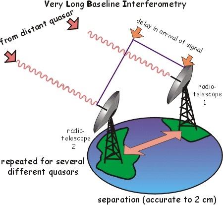
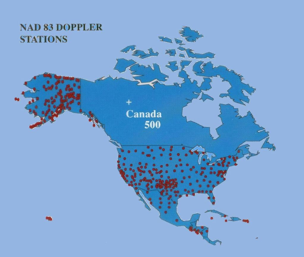
5 COMPARISON OF DATUM ELEMENTS NAD 27 ELLIPSOID DATUM POINT ADJUSTMENT BEST FITTING CLARKE 1866 GRS80 a = 6,378,206.4 m 1/f = Triangulation Station MEADES RANCH, KANSAS 25k STATIONS Several Hundred Base Lines Several Hundred Astro Azimuths North America NAD 83 a = 6,378,137. M 1/f = NONE EARTH MASS CENTER 250k STATIONS Appox. 30k EDMI Base Lines 5k Astro Azimuths Doppler Point Positions VLBI Vectors World-Wide

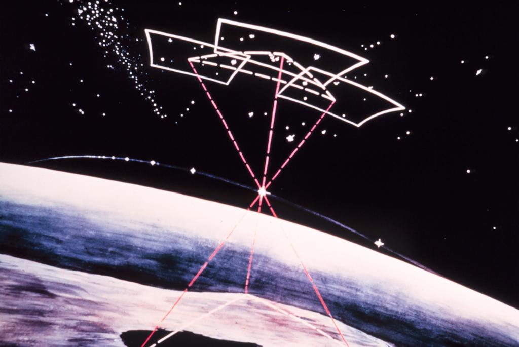
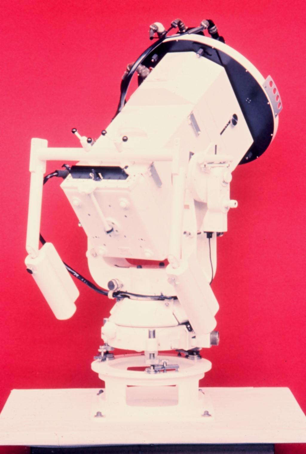
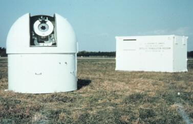
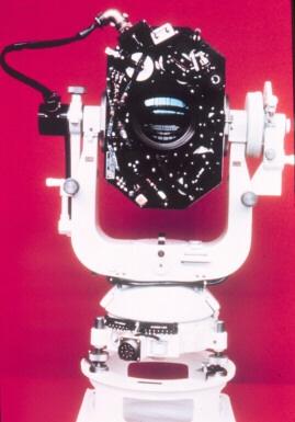
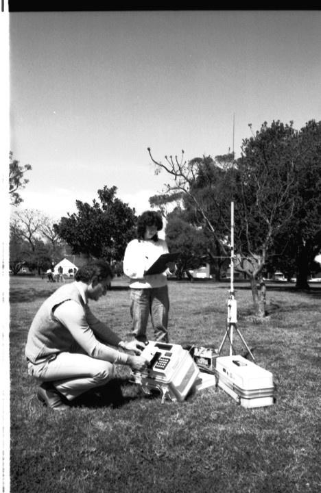
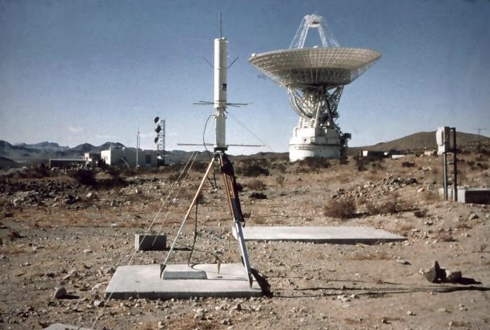
6 BC-4 Camera Program
7

8
9 BC-4 camera photograph stars in circular pattern satellite is a series of dots in straight line.
10
11 What is to be done?

12 NGS to the rescue!
13
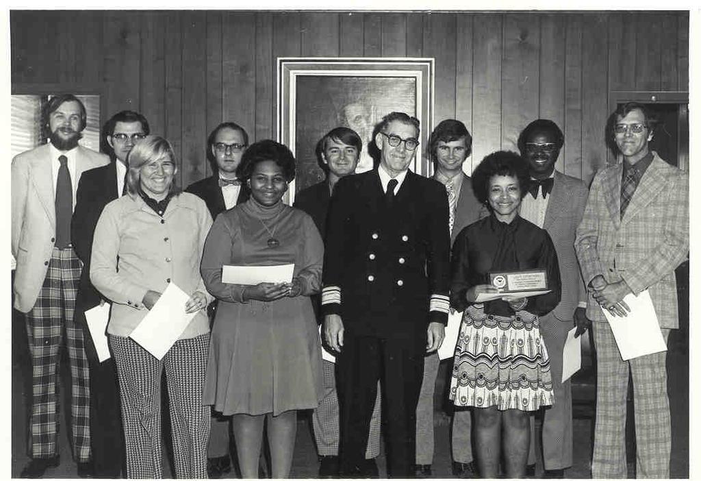
14 NAD 83 Project Digitized observations from 1800s-1980s 300 persons, at some time in 12 years, worked on NAD 83 $37M (in 1974 dollars) 1,000,000 simultaneous equations solved using Helmert Blocking! Doppler and VLBI, but mostly terrestrial observations NAD 83 released with datum origin moved to Center Of Mass (COM) of Earth
15
16
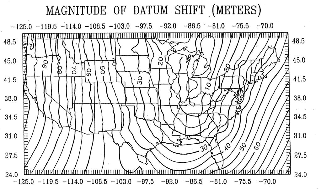
17 NAD 27 and NAD 83 NAD 27 and NAD 83
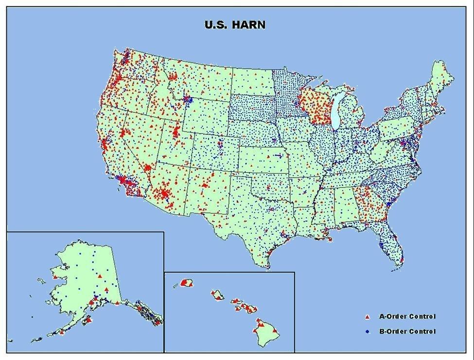
18 Problems with NAD 83 (1986) In 1980's GPS was adopted and as a result: Improved length determinations Observation of non-intervisible stations Ellipsoid heights now available from GPS Led to development of hybrid geoid models like GEOID To deal with these issues a state-by-state campaign of precise GPS observations was made.
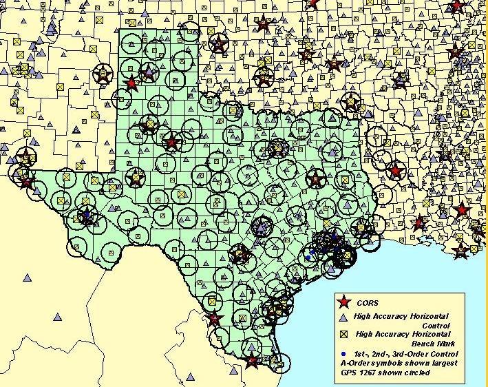
19 NETWORK STATUS HPGN/HARN SURVEYS 1991 GPS341 GPS197 reos 7/96 GPS1047 GPS404 GPS GPS GPS GPS805 GPS GPS GPS633 GPS GPS GP S291 reobs 9/ GPS1150 reos-6/95-gp S904 GPS GPS725 GPS GPS908 GPS P199 S 1 GPS GPS610 GPS GPS GPS GPS G GPS882 GPS1178 os 19 GPS730 GPS re 1994 reos 1/96 GPS936 S1 70 GPS383 GPS366 GPS GPS222 -G P GPS GPS667 GPS & CLASSICAL ADJUSTMENTS COMPLETED. GPS ADJUSTMENT COMPLETED GPS577 In Texas GPS-725 original HARN and subsequent campaign to improved ellipsoid height GPS-1267 in 1998.
20

21 Texas HARN GPS-725
22 HARN surveys Monument categories Federal Base Network Cooperative Base Network User Densification Network Survey accuracies GPS brought about new accuracy measures from AA, A, B, C (0.01ppm to 10 ppm respectively) State-by-state approach resulted in use of adjustment date tags e.g. NAD 83(1993) refers to the date of Texas HARN.

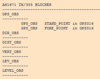
23 Intended policy regarding FBN in fact NOT realized.
24 Old FGCS Standards Order Base error (e) cm Line length dependent error (p) ppm Line length error as a ratio AA :100,000,000 A :10,000,000 B :1,000,000 C (1) :100,000 Accuracies shown are at 95% confidence level. Compute allowed error as sqrt(e2 + (0.1 * p * d)2 ) where d is the baseline distance in kilometers.

25 Observations At time of 1993 HARN, the requirement was for two eight-hour sessions at each site. Few GPS satellites most of the time Selective availability in effect. Primary interest in horizontal positions. In 1998 things changed...
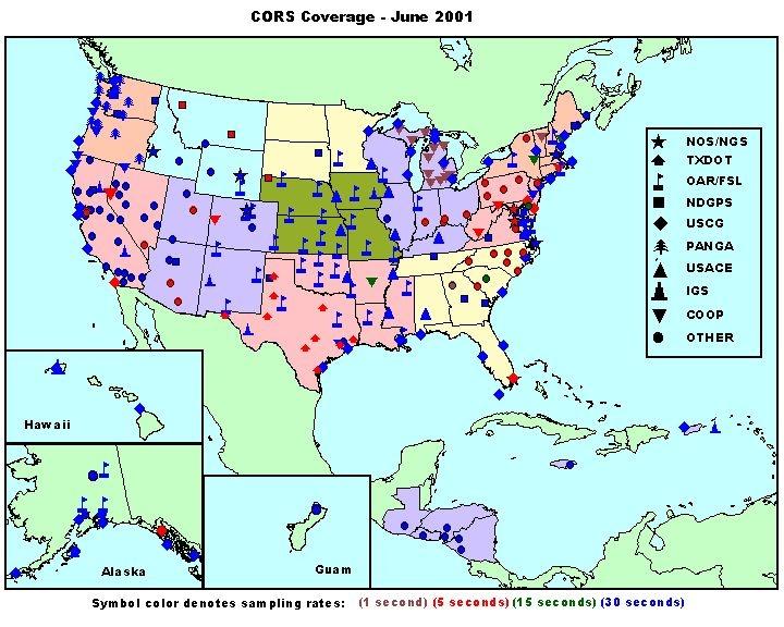
26 FBN Reobservation Campaign With advances in GPS and recognition of the usefulness of it for height determination (ellipsoid) another state-by-state campaign was initiated. Texas project was observed as GPS
27
28
29
30 Changes at Blucher Tag Lat deg min sec Lon deg min sec Difference with respect to n.a m m As seen on the preceding slide, the station was observed in only one campaign. The position changes result from the use of these observations in combination with other data and projects. Where is BLUCHER now?
31 Improving Positional Accuracy NETWORK TIME SPAN NETWORK ACCURACY LOCAL ACCURACY NAD METERS (1 part in 100,000) NAD83(86) METER HARN METER CORS meter (1 part in 100,000) B-order (1 part in 1 million) A-order (1 part in 10 million) 0.01 meter
32

33 NGS CORS Status March 2009
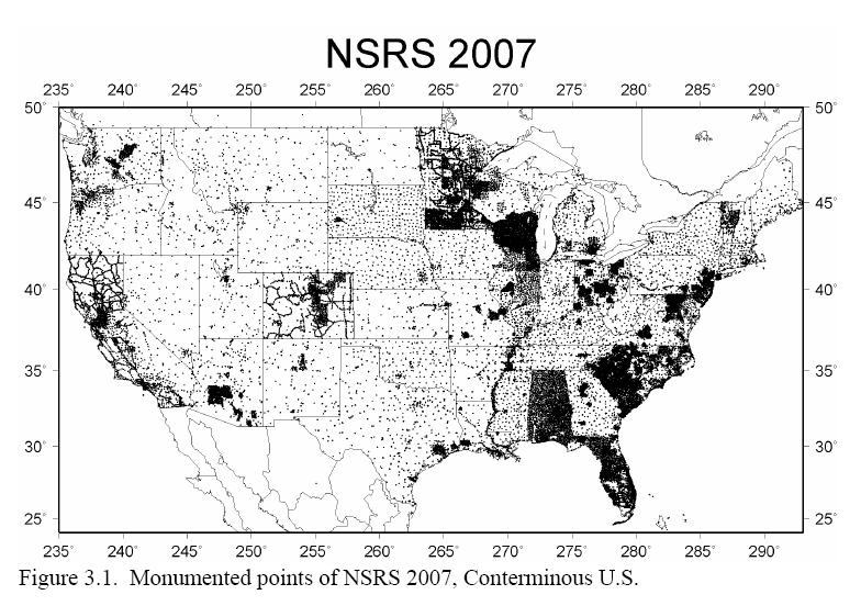
34 NAD 83 (NSRS 2007) Project Remove inconsistencies between states Make consistent with CORS Compute Network and Local accuracies for points. September 24, 2003 NGS Executive Steering Committee approved a plan for the readjustment of the horizontal positions and ellipsoid heights for GPS stations in the contiguous United States. Orthometric Height adjustment not attempted.
")
35 NGS Adjustment Team NGS Adjustment Team(1986) (2005)
36 Data used in NAD 83 (NSRS 2007) Adjustment ONLY GPS DATA WAS USED CONTINUOUSLY OPERATING REFERENCE STATIONS (CORS) FEDERAL BASE NETWORK COOPERATIVE BASE NETWORK USER DENSIFICATION NETWORK AIRPORT SURVEYS
37
38
39 Project Adjustment Analysis 3436 Projects Free Adjustment Residual Plot Outliers Rejected Connectivity to A/B Order Network Verified Summary sheet with Project Information Created stations
40 The basic stats of NSRS projects 67,693 points (203,079 unknowns) 283,691 vectors (851,073 observations) 673 CORS fixed ( m σ in 3-D) Variance of unit weight: 1.892
41
42
43 Network Accuracy Network accuracy of a control point A value that represents the uncertainty of its coordinates with respect to the geodetic datum at the 95-percent confidence level Datum is considered to be best expressed by the Continuous Operating Reference Stations (CORS) Local and Network accuracy values at CORS sites are considered to be infinitesimal (approach zero) These accuracies will be implemented with the National Readjustment
Lecture 14 NAD 83(NSRS), NAD 83(CORS 96), WGS84 and ITRF
, NAD 83(CORS 96), WGS84 and ITRF") Lecture 14 NAD 83(NSRS), NAD 83(CORS 96), WGS84 and ITRF Monday, March 1, 2010 2 March 2010 GISC3325 NAD 27 and NAD 83 NAD 27 and NAD 83 Versions of NAD 83 First implementation labeled NAD 83 (1986). Deficiencies
Lecture 14 NAD 83(NSRS), NAD 83(CORS 96), WGS84 and ITRF Monday, March 1, 2010 2 March 2010 GISC3325 NAD 27 and NAD 83 NAD 27 and NAD 83 Versions of NAD 83 First implementation labeled NAD 83 (1986). Deficiencies
LAB PROCEDURES: TOPCON TOOLS FAMILIARIZATION
 LAB PROCEDURES: TOPCON TOOLS FAMILIARIZATION This lab will cover the basic setup and processing options of Topcon Tools (TT). We will learn how to start a project, upload data and control files, set up
Lecture # 7 Coordinate systems and georeferencing
 Lecture # 7 Coordinate systems and georeferencing Coordinate Systems Coordinate reference on a plane Coordinate reference on a sphere Coordinate reference on a plane Coordinates are a convenient way of
ELEMENTS OF THE NATIONAL SPATIAL REFERENCE SYSTEM
 Dave Doyle NGS Chief Geodetic Surveyor dave.doyle@noaa.gov 301-713-3178 ELEMENTS OF THE NATIONAL SPATIAL REFERENCE SYSTEM ESRI SURVEY SUMMIT San Diego, CA June 17, 2007 ftp://ftp.ngs.noaa.gov/dist/daved/esri
Geodesy, Geographic Datums & Coordinate Systems
 Geodesy, Geographic Datums & Coordinate Systems What is the shape of the earth? Why is it relevant for GIS? 1/23/2018 2-1 From Conceptual to Pragmatic Dividing a sphere into a stack of pancakes (latitude)
Datums and Tools to Connect Geospatial Data Accurately
 Datums and Tools to Connect Geospatial Data Accurately Pamela Fromhertz Colorado State Geodetic Advisor National Geodetic Survey National Oceanic and Atmospheric Administration GIS-T April 18, 2012 Loveland,
Using GPS to Establish the NAVD88 Elevation on Reilly The A-order HARN Station at NMSU
 Using GPS to Establish the NAVD88 Elevation on Reilly The A-order HARN Station at NMSU Earl F. Burkholder, PS, PE New Mexico State University Las Cruces, NM 88003 July 005 Introduction GPS has become an
Chapter 6 GPS Relative Positioning Determination Concepts
 Chapter 6 GPS Relative Positioning Determination Concepts 6-1. General Absolute positioning, as discussed earlier, will not provide the accuracies needed for most USACE control projects due to existing
An NGS Illustrated Guide to Geodesy for GIS Professionals
 An NGS Illustrated Guide to Geodesy for GIS Professionals Michael Dennis, RLS, PE michael.dennis@noaa.gov Esri User Conference San Diego Convention Center July 14-18, 2014 San Diego, CA Why should we care
Basic Geodetics. Bobby Saleh Guidon Energy April 13, 2017
 Experts in Geomatics, Surveying, Positioning, Geospatial Data, and Mapping Sciences Basic Geodetics Bobby Saleh Guidon Energy b.saleh@guidonenergy.com April 13, 2017 The Earth is NOT flat Q: So what does
Determining Accurate Elevations: Datums & Tools, Today & Tomorrow
 Determining Accurate Elevations: Datums & Tools, Today & Tomorrow Association of State Floodplain Managers Annual Meeting Grand Rapids, MI Christine Gallagher June 21, 2016 Overview NGS Mission Important
Introduction to Datums James R. Clynch February 2006
 Introduction to Datums James R. Clynch February 2006 I. What Are Datums in Geodesy and Mapping? A datum is the traditional answer to the practical problem of making an accurate map. If you do not have
Overview of New Datums
 Overview of New Datums Scott Lokken NC Advisor NOAA s National Geodetic Survey 9/4/2015 1 New Datums are Coming in 2022! Both a new geometric and a new geopotential (vertical) datum will be released in
Determining Accurate Elevations: Datums & Tools, Today & Tomorrow
 Determining Accurate Elevations: Datums & Tools, Today & Tomorrow Maryland Association Floodplain and Stormwater Managers Linthicum Heights, MD Christine Gallagher Oct. 20, 2016 Overview NGS Mission Important
GROUND CONTROL SURVEY REPORT
 GROUND CONTROL SURVEY REPORT Services provided by: 3001, INC. a Northrop Grumman company 10300 Eaton Place Suite 340 Fairfax, VA 22030 Ground Control Survey in Support of Topographic LIDAR, RGB Imagery
BILL HENNING, Prof LS. ACRONYMS
 BILL HENNING, Prof LS. ACRONYMS US 1 WIKIPEDIA: Also known as geodetics, geodetic engineering or geodetics engineering a branch of applied mathematics [2] and earth sciences, is the scientific discipline
BILL HENNING, Prof LS.
 BILL HENNING, Prof LS. DEFINITIONS: GEODESY, DATUMS, NSRS ACCESSING THE DATUM REALIZATION: PASSIVE MARKS, ACTIVE STATIONS WORLD SCIENTIFIC DATUMS HORIZONTAL, GEOMETRIC, VERTICAL, GRAVIMETRIC DATUMS IN
WISCONSIN COORDINATE SYSTEMS
 Pdf versions of the Handout and Powerpoint slides are on jerrymahun.com. Follow the USPLSS Forum link and use the password: WildT2 WISCONSIN COORDINATE SYSTEMS CONCEPTS & IMPLEMENTATION Jerry Mahun, PLS,
Utilizing A GNSS Network Solution for Utility Applications
 Utilizing A GNSS Network Solution for Utility Applications David Newcomer, PE, PLS GPServ, Inc. newcomer@ (407) 601-5816 AGENDA Types and accuracies of data collection o Autonomous o Meter + o Sub-meter
National Height Modernization: Cost comparison of conducting a vertical survey by leveling versus by GPS in western North Carolina
 Introduction: National Height Modernization: Cost comparison of conducting a vertical survey by leveling versus by GPS in western North Carolina The North Carolina Geodetic Survey (NCGS) conducted a National
GNSS 101 Bringing It Down To Earth
 GNSS 101 Bringing It Down To Earth Steve Richter Frontier Precision, Inc. UTM County Coordinates NGVD 29 State Plane Datums Scale Factors Projections Session Agenda GNSS History & Basic Theory Coordinate
NSRS Modernization Update
 geodesy.noaa.gov NSRS Modernization Update Scott Lokken National Geodetic Survey, NOAA Mid Atlantic Regional Geodetic Advisor Oct 05, 2017 Maryland Society of Surveyors Fall Conference NGS Regional Geodetic
FieldGenius Technical Notes GPS Terminology
 FieldGenius Technical Notes GPS Terminology Almanac A set of Keplerian orbital parameters which allow the satellite positions to be predicted into the future. Ambiguity An integer value of the number of
The Tennessee Geodetic Reference Network (TGRN): An Update*
: An Update*") The Tennessee Geodetic Reference Network (TGRN): An Update* James H. Zeigler Tennessee Department of Transportation INTRODUCTION As the Tennessee Department of Transportation (T.D.O.T.) considered the
The Tennessee Geodetic Reference Network (TGRN): An Update* James H. Zeigler Tennessee Department of Transportation INTRODUCTION As the Tennessee Department of Transportation (T.D.O.T.) considered the
Datums for a Dynamic Earth
 Datums for a Dynamic Earth Based on a paper given at the American Society of Agricultural and Biological Engineers (ASABE) Conference in Reno, Nevada June 2009 Rollin StrohmanPh.D. Tom Mastin L.S Background
Overview of New Datums NOAA s National Geodetic Survey
 Overview of New Datums NOAA s National Geodetic Survey February 3, 2015 1 NGS s Mission and Role NGS Mission: To define, maintain, and provide access to the National Spatial Reference System to meet our
TDS Ranger Survey Pro CE Version RTK Base on known Control Point. RTK Rover - Localization with Control Points.
 TDS Ranger Survey Pro CE Version 2.1.8 RTK Base on known Control Point. RTK Rover - Localization with Control Points. Pre-load control Coordinates and appropriate NGS Geoid 99/96 data files into the Ranger
Coordinates, Datums, and Map Projection
 Coordinates, Datums, and Map Projection Two views on the World Intersect at 90 o angles Latitude/ Longitude is a Spherical System Acceptable latitudes/longitudes i) W125 o 27 33 ii) N92 o 45 12 iii)
GNSS & Coordinate Systems
 GNSS & Coordinate Systems Matthew McAdam, Marcelo Santos University of New Brunswick, Department of Geodesy and Geomatics Engineering, Fredericton, NB May 29, 2012 Santos, 2004 msantos@unb.ca 1 GNSS GNSS
High Precision GNSS for Mapping & GIS Professionals
 High Precision GNSS for Mapping & GIS Professionals Agenda Address your needs for GNSS knowledge. GNSS Basics Satellite Ranging Fundamentals (Code $ Carrier) Differential Corrections (Post Processed $
Understanding the Evolution of WGS 84 and NAD 83
 Summary Both WGS 84, the datum used by GPS,, commonly used in North America, have been redefined several times since their beginning. Parallel to this, there have also been several realizations of the
Suveying Lectures for CE 498
 Suveying Lectures for CE 498 SURVEYING CLASSIFICATIONS Surveying work can be classified as follows: 1- Preliminary Surveying In this surveying the detailed data are collected by determining its locations
Korean Geodetic Datum 2002(KGD2002): Nationwide GPS Network Densification
: Nationwide GPS Network Densification") Korean Geodetic Datum 2002(KGD2002): Nationwide GPS Network Densification Young-Jin LEE, Hung-Kyu LEE, Kwang-Ho JEONG, and Sang-Hun CHA, Republic of Korea Key words: KGD2002, GPS, Network Densification,
Korean Geodetic Datum 2002(KGD2002): Nationwide GPS Network Densification Young-Jin LEE, Hung-Kyu LEE, Kwang-Ho JEONG, and Sang-Hun CHA, Republic of Korea Key words: KGD2002, GPS, Network Densification,
Application of GPS/GNSS in Cybermapping. Cybermapping Lab University of Texas at Dallas 2009
 Application of GPS/GNSS in Cybermapping Cybermapping Lab University of Texas at Dallas 2009 GNSS Global Navigation Satellite System (GNSS) is the standard generic term for satellite navigation systems
CGG. Office of the Surveyor General of the Federation Federal Capital Territory, Abuja, Nigeria 2
 Prof. P. C. Nwilo 1, * Dr. J. D. Dodo 2, U. R. Edozie 1, and A. Adebomehin 1. 1 Office of the Surveyor General of the Federation Federal Capital Territory, Abuja, Nigeria 2 Centre for Geodesy and Geodynamics,
Specifications for Post-Earthquake Precise Levelling and GNSS Survey. Version 1.0 National Geodetic Office
 Specifications for Post-Earthquake Precise Levelling and GNSS Survey Version 1.0 National Geodetic Office 24 November 2010 Specification for Post-Earthquake Precise Levelling and GNSS Survey Page 1 of
Part VII: Control Surveying
 Part VII: Control Surveying Control Surveying consists of research, measurements, calculations and reports detailing the horizontal and vertical reference systems established for the survey. 7.1. Sources
TDS Survey Pro CE Version Setup RTK Base on known NAD83/WGS84 Point: Mapping Plane Geoid99 Modeling.
 TDS Survey Pro CE Version 2.1.8 Setup RTK Base on known NAD83/WGS84 Point: Mapping Plane Geoid99 Modeling. Pre-load known NAD83 State Plane Coordinates and appropriate NGS Geoid 99/96 data files into the
Salient Feature of ITRF. Realization of Dubai Emirate Datum. Reference Frame 2000 (Ditr 2000)
") Salient Feature of ITRF on the Reference Frame 2000 (Ditr 2000) ITRF stands for International Terrestrial Reference Frame ITRF established by the International Earth Rotation Service (IERS), France. One
Salient Feature of ITRF on the Reference Frame 2000 (Ditr 2000) ITRF stands for International Terrestrial Reference Frame ITRF established by the International Earth Rotation Service (IERS), France. One
Benefits and Impacts to Nautical Charting by Adopting a New Reference Frame. Dr. Neil Weston Office of Coast Survey, NOAA
 Benefits and Impacts to Nautical Charting by Adopting a New Reference Frame Dr. Neil Weston Office of Coast Survey, NOAA Motivation for this study NOAA s National Geodetic Survey New geometric reference
Guidelines for Laying Targets for Ground Control Points
 Guidelines for Laying Targets for Ground Control Points Overview of target requirements: Three to four unambiguous ground survey targets, recognizable in the satellite photo, are requested. The survey
GPS Pathfinder Office Software or the GPS Analyst Extension for ESRI ArcGIS Software: Resolving the NAD 83 Datum Transformation Issue
 Mapping & GIS Support Note 5 May 2005 GPS Pathfinder Office Software or the GPS Analyst Extension for ESRI ArcGIS Software: Resolving the NAD 83 Datum Transformation Issue Summary The current realizations
9/26/2016. Accuracy with GNSS What are you getting? Presented By Tom Bryant PLS Kelly Harris PLS Seiler Instrument
 Accuracy with GNSS What are you getting? Presented By Tom Bryant PLS Kelly Harris PLS Seiler Instrument 1 What We Will Talk About Today What coordinate system should I use in my data collector Site Calibrations-what
AUSPOS GPS Processing Report
 AUSPOS GPS Processing Report February 13, 2012 This document is a report of the GPS data processing undertaken by the AUSPOS Online GPS Processing Service (version: AUSPOS 2.02). The AUSPOS Online GPS
Definition and use of the New Zealand Vertical Datum Matt Amos Senior Advisor Geodesy
 Definition and use of the New Zealand Vertical Datum 2009 Matt Amos Senior Advisor Geodesy NZIS Continuing Professional Development Programme, November 2009 Overview Height Theory Heights in New Zealand
GPS for. Land Surveyors. Jan Van Sickle. Fourth Edition. CRC Press. Taylor & Francis Group. Taylor & Francis Croup, an Informa business
 GPS for Land Surveyors Fourth Edition Jan Van Sickle CRC Press Taylor & Francis Group Boca Raton London New York CRC Press is an imprint of the Taylor & Francis Croup, an Informa business Contents Preface
Using RTK GNSS Wisely
 Using RTK GNSS Wisely February 017 Autonomous Positioning Differential Positioning Concept: Detect and cancel identical errors with simultaneous observation. F + E = G + E 1 Static & RTK Computations Static
CHAPTER 2 GEODESY AND DATUMS IN NAVIGATION
 CHAPTER 2 GEODESY AND DATUMS IN NAVIGATION GEODESY, THE BASIS OF CARTOGRAPHY 200. Definition Geodesy is the science concerned with the exact positioning of points on the surface of the earth. It also involves
A NEW GEOCENTRIC DATUM FOR NEW ZEALAND
 A NEW GEOCENTRIC DATUM FOR NEW ZEALAND Don Grant Graeme Blick Office of Surveyor-General Land Information New Zealand PO Box 5501 Wellington New Zealand Phone 04 4600100 Fax 04 4722244 dgrant@linz.govt.nz
TECHNICAL REPORT NO. 45 TECHNICAL REVIEW AND REEVALUATION OF THE REGIONAL CONTROL SURVEY PROGRAM IN SOUTHEASTERN WISCONSIN
 TECHNICAL REPORT NO. 45 TECHNICAL REVIEW AND REEVALUATION OF THE REGIONAL CONTROL SURVEY PROGRAM IN SOUTHEASTERN WISCONSIN SOUTHEASTERN WISCONSIN REGIONAL PLANNING COMMISSION SOUTHEASTERN WISCONSIN REGIONAL
Datum Transformations: Nightmare on GIS Street. Agenda
 Datum Transformations: Nightmare on GIS Street Speaker: Eric Gakstatter Contributing Editor GPS World Editor - Geospatial Solutions Presented at: Minnesota Society of Professional Surveyors Bloomington,
DATUM TRANSFORMATION BETWEEN NATIONAL GEODETIC DATUM AND ITRF
 DATUM TRANSFORMATION BETWEEN NATIONAL GEODETIC DATUM AND ITRF M.Sc. Zlatko Bogdanovsk i FCE Skopje Chair for High Geodesy INTRODUCTION COORDINATE TRANSFORMATION Need of establishing dependence between
High Precision Positioning Unit 1: Accuracy, Precision, and Error Student Exercise
 High Precision Positioning Unit 1: Accuracy, Precision, and Error Student Exercise Ian Lauer and Ben Crosby (Idaho State University) This assignment follows the Unit 1 introductory presentation and lecture.
Session 1.2 Regional and National Reference Systems. Asia Pacific. Dr John Dawson Leader - National Geodesy Program Geoscience Australia
 Session 1.2 Regional and National Reference Systems Asia Pacific Dr John Dawson Leader - National Geodesy Program Geoscience Australia Presentation Overview Part 1 Australia s contributions to the ITRF
Standard for the Australian Survey Control Network
 Standard for the Australian Survey Control Network Special Publication 1 Intergovernmental Committee on Survey and Mapping (ICSM) Geodesy Technical Sub-Committee (GTSC) 30 March 2012 Table of contents
Table of Contents. Frequently Used Abbreviation... xvii
 GPS Satellite Surveying, 2 nd Edition Alfred Leick Department of Surveying Engineering, University of Maine John Wiley & Sons, Inc. 1995 (Navtech order #1028) Table of Contents Preface... xiii Frequently
PROCEDURE FOR GNSS EQUIPMENT VERIFICATION IN STATIC POSITIONING
 M. Tsakiri, V. Pagounis, V. Zacharis Procedure for GNSS equipment verification in static positioning PROCEDURE FOR GNSS EQUIPMENT VERIFICATION IN STATIC POSITIONING Maria TSAKIRI, School of Rural and Surveying
DYNAMIC RT TECHNOLOGY
 DYNAMIC RT TECHNOLOGY GLOBAL NAVIGATION SATELLITE SYSTEMS (GNSS) POTENTIAL FUTURE DEVELOPMENTS(2005 2017?) GPS MODERNIZATION BLOCK IIF & III GLONASS ENHANCEMENTS (K & M) EUROPEAN UNION - GALILEO CHINA
The Global Positioning System II Field Experiments
 The Global Positioning System II Field Experiments 5-1 Mexico DGPS Field Campaign Cenotes in Tamaulipas, MX, near Aldama 5-2 Are Cenote Water Levels Related? 5-3 DGPS Static Survey of Cenote Water Levels
Philippine Geodetic Infrastructure Status, Challenges and Future Direction
 Philippine Geodetic Infrastructure Status, Challenges and Future Direction Engr. Charisma Victoria D. Cayapan National Mapping and Resource Information Authority PHILIPPINES Outline Evolution of Geodetic
GPS Technical Aspects
 GPS Technical Aspects Charles Ghilani (cghilani@psu.edu) Turn off all cell phones Or set them to vibrate Class Etiquette Ask questions at any point during the class. Simply speak up so that all can hear
The Global Positioning Sytem II 10/19/2017
 The Global Positioning System II Field Experiments 10/19/2017 5-1 Mexico DGPS Field Campaign Cenotes in Tamaulipas, MX, near Aldama 10/19/2017 5-2 Are Cenote Water Levels Related? 10/19/2017 5-3 M. Helper,
Global Positioning Systems -GPS
 Global Positioning Systems -GPS GPS Why? What is it? How does it work? Differential GPS How can it help me? GPS Why?? Where am I? How do I get there? Where are you, and how do I get to You? WHO CARES???
Connecting a Survey to PNG94 and MSL using GNSS
 45th Association of Surveyors PNG Congress, Madang, 19-22 July 2011 Connecting a Survey to PNG94 and MSL using GNSS Richard Stanaway QUICKCLOSE Workshop overview Legal requirements to connect surveys to
Global Positioning Systems - GPS
 Global Positioning Systems - GPS GPS Why? What is it? How does it work? Differential GPS How can it help me? GPS Why?? Where am I? How do I get there? Where are you, and how do I get to You? WHO CARES???
CHAPTER 2 GEODESY AND DATUMS IN NAVIGATION
 CHAPTER 2 GEODESY AND DATUMS IN NAVIGATION GEODESY, THE BASIS OF CARTOGRAPHY 200. Definition Geodesy is the application of mathematics to model the size and shape of the physical earth, enabling us to
Connecting a Cadastral Survey to PNG94 using GNSS
 43rd Association of Surveyors PNG Congress, Lae, 12th-15th August 2009 Connecting a Cadastral Survey to PNG94 using GNSS Richard Stanaway QUICKCLOSE Workshop overview Legal requirements to connect surveys
NAVSTAR Global Positioning System Surveying
 1 August 1996 US Army Corps of Engineers ENGINEERING AND DESIGN NAVSTAR Global Positioning System Surveying ENGINEER MANUAL 1 DEPARTMENT OF THE ARMY EM 1110-1-1003 U.S. Army Corps of Engineers CECW-EP
Record 2013/01 GeoCat 75057
 Record 2013/01 GeoCat 75057 Determination of GDA94 coordinates for station CCMB at the Clermont Coal Mine of Rio Tinto Coal Australia (RTCA) in central Queensland using the October and November 2012 GPS
GUIDELINES FOR MANAGING
 GUIDELINES FOR MANAGING A GPS BASED CONTROL SYSTEM IN THE MARITIME PROVINCES Version 1.0 prepared for Maritime GPS Implementation Committee prepared by Geoplan Consultants Inc. in association with Gillis
Record 2013/06 GeoCat 75084
 Record 2013/06 GeoCat 75084 Determination of GDA94 coordinates for station CAVL at the Caval Ridge Mine of RPS Australia East Pty Ltd in Queensland using the November 2012 GPS data set G. Hu, J. Dawson
Record 2012/76 GeoCat 74975
 Record 2012/76 GeoCat 74975 Determination of GDA94 coordinates for station GRBA at the Goonyella Riverside Mine of the BHP Billiton Mitsubishi Alliance (BMA) in central Queensland using the September and
PREFACE. National Geographic Department would like to express our sincere thanks for your comments.
 PREFACE According to the role of National Geographic Department on Prim Minister s Decree No 255 PM, dated August 16, 2005 regarding to Surveying, Aerial Photography and mapping activities in the territory
Unification of height systems in the frame of GGOS
 Unification of height systems in the frame of GGOS Laura Sánchez Deutsches Geodätisches Forschungsinstitut der Technischen Universität München (DGFI-TUM) Centrum für Geodätische Erdsystemforschung (CGE)
Appendix A Lower Columbia River Chart Datum Modeling
 Appendix A Lower Columbia River Chart Datum Modeling David Evans and Associates, Inc. David Evans and Associates, Inc. 2801 SE Columbia Way, Ste. 130 Vancouver, WA 98661 (360) 314-3200 1.0 Vertical Datum
Progress Towards the Seamless Combination of Bathymetric and Topographic Data in New Zealand
 Progress Towards the Seamless Combination of Bathymetric and Topographic Data in New Zealand Matt Amos Senior Technical Advisor National Geodetic Office Introduction Datasets usually defined in terms of
The Global Positioning System II Field Experiments. 10/10/2013 GEO327G/386G, UT Austin 5-1
 The Global Positioning System II Field Experiments 10/10/2013 GEO327G/386G, UT Austin 5-1 Mexico DGPS Field Campaign Cenotes in Tamaulipas, MX, near Aldama 10/10/2013 GEO327G/386G, UT Austin 5-2 Are Cenote
National Report of Greece to EUREF 2009
 National Report of Greece to EUREF 2009 M. Gianniou KTIMATOLOGIO S.A. (Hellenic Cadastre) 1 Introduction In 2007, KTIMATOLOGIO S.A (Hellenic Cadastre) established HEPOS, the HEllenic POsitioning System,
IAG School on Reference Systems June 7 June 12, 2010 Aegean University, Department of Geography Mytilene, Lesvos Island, Greece SCHOOL PROGRAM
 IAG School on Reference Systems June 7 June 12, 2010 Aegean University, Department of Geography Mytilene, Lesvos Island, Greece SCHOOL PROGRAM Monday June 7 8:00-9:00 Registration 9:00-10:00 Opening Session
SURVEYORS BOARD OF QUEENSLAND. RTK GNSS for Cadastral Surveys. Guideline
 SURVEYORS BOARD OF QUEENSLAND RTK GNSS for Cadastral Surveys Guideline 30 November 2012 RTK GNSS for Cadastral Surveys General The Surveyors Board of Queensland has recently become aware of some issues
What makes the positioning infrastructure work. Simon Kwok Chairman, Land Surveying Division Hong Kong Institute of Surveyors
 What makes the positioning infrastructure work The experience of the Hong Kong Satellite Positioning Reference Station Network Simon Kwok Chairman, Land Surveying Division Hong Kong Institute of Surveyors
Principles of the Global Positioning System Lecture 19
 12.540 Principles of the Global Positioning System Lecture 19 Prof. Thomas Herring http://geoweb.mit.edu/~tah/12.540 GPS Models and processing Summary: Finish up modeling aspects Rank deficiencies Processing
NJDEP GPS Data Collection Standards for GIS Data Development
 NJDEP GPS Data Collection Standards for GIS Data Development Bureau of Geographic Information Systems Office of Information Resource Management April 24 th, 2017 Table of Contents 1.0 Introduction... 3
Record 2011/02. GeoCat # M. Jia, J. Dawson APPLYING GEOSCIENCE TO AUSTR ALIA S MOST IMPORTANT CHALLENGES
 G E O S C I E N C E A U S T R A L I A Correction to Determination of GDA94 coordinates for eleven Queensland Department of Environment and Resource Management CORS stations using the August 2010 GPS data
Global IGS/GPS Contribution to ITRF
 Global IGS/GPS Contribution to ITRF R. Ferland Natural ResourcesCanada, Geodetic Survey Divin 46-61 Booth Street, Ottawa, Ontario, Canada. Tel: 1-613-99-42; Fax: 1-613-99-321. e-mail: ferland@geod.nrcan.gc.ca;
Geodetic policy for Ireland and Northern Ireland
 Geodetic policy for Ireland and Northern Ireland Background Ordnance Survey Ireland (OSi) is the National Mapping Agency (NMA) of the Republic of Ireland. The Ordnance Survey of Northern Ireland (OSNI)
Satellite Navigation Integrity and integer ambiguity resolution
 Satellite Navigation Integrity and integer ambiguity resolution Picture: ESA AE4E08 Sandra Verhagen Course 2010 2011, lecture 12 1 Today s topics Integrity and RAIM Integer Ambiguity Resolution Study Section
Technical Aspects in the Upgrading and Implementation of PRS92
 Technical Aspects in the Upgrading and Implementation of PRS92 (Engr.) Sergio C. Abad II GeoAnalytika This is a modified paper presented at the FY 2003 Policy Forum and Mid-Year Assembly of the Geodetic
Determination of GDA94 coordinates for station PDM1 at BMA s Peak Downs Mine in central Queensland using the June 2013 GPS data set
 Record 2013/42 GeoCat 76764 Determination of GDA94 coordinates for station PDM1 at BMA s Peak Downs Mine in central Queensland using the G. Hu, J. Dawson APPLYING GEOSCIENCE TO AUSTRALIA S MOST IMPORTANT
COMPARISON OF GPS COMMERCIAL SOFTWARE PACKAGES TO PROCESSING STATIC BASELINES UP TO 30 KM
 COMPARISON OF GPS COMMERCIAL SOFTWARE PACKAGES TO PROCESSING STATIC BASELINES UP TO 30 KM Khaled Mohamed Abdel Mageed Civil Engineering, Cairo, Egypt E-Mail: khaled_mgd@yahoo.com ABSTRACT The objective
Published in: Water Science Magazine, No. 33, 2003, April. pp PROPOSED STANDARDS AND SPECIFICATIONS FOR GPS GEODETIC SURVEYS IN EGYPT
 Published in: Water Science Magazine, No. 33, 2003, April. pp. 33-39. PROPOSED STANDARDS AND SPECIFICATIONS FOR GPS GEODETIC SURVEYS IN EGYPT By Gomaa M. Dawod Researcher, Survey Research Institute ABSTRACT
Applications, Products and Services of GPS Technology
 Applications, Products and Services of GPS Technology Enrico C. Paringit. Dr. Eng. University of the Philippines Training Center for Applied Geodesy and Photogrammetry 1 Outline of this Presentation GPS
21st International Conference of The Coastal Society
 21st International Conference of The Coastal Society DEVELOPMENT OF A VERTICAL DATUM TRANSFORMATION TOOL AND A BATHYMETRIC/TOPOGRAPHIC DIGITAL ELEVATION MODEL FOR SOUTHERN CALIFORNIA Edward P. Myers, NOAA/NOS
Geodetic Positioning Refresher
 Geodetic Positioning Refresher by Joan Yau PhD ABCLS AGM 2016, Kimberley BC Contents Horizontal / Vertical Datums and Epochs used in BC and Canada How do we reference our project coordinates to BC datums
From Passive to Active Control Point Networks Evaluation of Accuracy in Static GPS Surveying
 From Passive to Active Control Point Networks Evaluation of Accuracy in Static GPS Surveying P. Häkli 1, U. Kallio 1 and J. Puupponen 2 1) Finnish Geodetic Institute 2) National Land Survey of Finland
GPS Pathfinder Office Software or GPS Analyst Extension for ESRI ArcGIS Software: Resolving the NAD 83 Datum Transformation Issue
 13 June 2011 GPS Pathfinder Office Software or GPS Analyst Extension for ESRI ArcGIS Software: Resolving the NAD 83 Datum Transformation Issue Summary The current realizations of the North American Datum
LAB 1 METHODS FOR LOCATING YOUR FIELD DATA IN GEOGRAPHIC SPACE. Geog 315 / ENSP 428
 LAB 1 METHODS FOR LOCATING YOUR FIELD DATA IN GEOGRAPHIC SPACE Geog 315 / ENSP 428 Lab 1 Schedule Introduction to bio-physical field data collection (8:00-8:20am) Locating your data on the earth: NAVSTAR
Indian Institute of Technology Kanpur Department of Civil Engineering
 Indian Institute of Technology Kanpur Department of Civil Engineering Inquiry No- CE/JNM/2013-14/R-10 30 December, 2013 Subject: Quotation for supply of Integrated System/Smart System Reflectorless Robotic
OPTIMUM GEODETIC DATUM TRANSFORMATION TECHNIQUES FOR GPS SURVEYS IN EGYPT
 Proceedings of Al-Azhar Engineering Sixth International Conference, Sept. 1-, 2000, Cairo, Egypt, Volume, pp. 09-1. OPTIMUM GEODETIC DATUM TRANSFORMATION TECHNIQUES FOR GPS SURVEYS IN EGYPT By Dr. Gomaa
LINCOLN COUNTY LAND INFORMATION & CONSERVATION DEPARTMENT Lincoln County Service Center 801 N Sales Street-Suite 105 Merrill, WI 54452
 LINCOLN COUNTY LAND INFORMATION & CONSERVATION DEPARTMENT Lincoln County Service Center 801 N Sales Street-Suite 105 Merrill, WI 54452 Phone (715) 539-1049 Fax (715) 539-8093 Date: September 27, 2011 To: