NSRS Modernization Update
|
|
|
- Clement Austin
- 6 years ago
- Views:
Transcription
1 geodesy.noaa.gov NSRS Modernization Update Scott Lokken National Geodetic Survey, NOAA Mid Atlantic Regional Geodetic Advisor Oct 05, 2017 Maryland Society of Surveyors Fall Conference


2 NGS Regional Geodetic Advisors 3916 Sunset Ridge Rd Raleigh, NC cell work 2
3 Session description and objectives In 2022, the National Geodetic Survey will be replacing the U.S. horizontal and vertical datums (NAD 83 and NAVD 88). We will discuss the history of these datums, their relationship to other reference frames, the reasons for the change, and how it affects surveyors and their access to these datums. Objective gain a fundamental understanding of: How and why our datums/reference frames have changed over time The need to further modernize the US reference frames How NGS will define new reference frames How users will access the new reference frames 3
4 New Datums are Coming in 2022! -Where are we now? -Where are we going? (2022 will be here sooner than we think!) 4
5 What is a Datum? "A set of constants specifying the coordinate system used for geodetic control, i.e., for calculating the coordinates of points on the Earth." "The datum, as defined above, together with the coordinate system and the set of all points and lines whose coordinates, lengths, and directions have been determined by measurement or calculation." 5
6 INTRODUCTION: THE NSRS 7

7 National Spatial Reference System (NSRS) NGS Mission: To define, maintain & provide access to the National Spatial Reference System (NSRS) to meet our Nation s economic, social & environmental needs Consistent National Coordinate System Latitude/Northing Longitude/Easting Height Scale Gravity Orientation and how these values change with time.
8 Overview The National Spatial Reference System (NSRS) is the official coordinate system for all geospatial work done by the civilian federal government. Current datums: NAD 83 (latitude, longitude, ellipsoid height) NAVD 88 (orthometric height) IGLD 85 (dynamic heights: predominantly on the Great Lakes) These datums are often adopted, even legislated, by states, counties and municipalities. 9


9 Why Modernize? Older Methodology Terrestrial, pre-space-geodesy, line-of-sight observations Easily destroyed, unmonitored passive control marks 10
10 Historical datums/realizations NAD27 based on old observations and old datum NAD83(86) based on old observations and new datum NAD83(91) based on new and old observations and same datum (original HARN) NAD83(????) based on better observations and same datum (FBN) NAD83(NSRS2007) based on new observations and same datum. Removed regional distortions and made consistent with CORS NAD83(2011) based on new observations and same datum. Consistent with new Multi Year CORS solution 11


11 Global Positioning System GPS Block I GPS Block II GPS Block III February 22, st NAVSTAR Satellite launched July 17, System Fully Operational May 1, Selective Availability turned off September 26, L2C band added May 28, First L5 Satellite added (12 L5 SVs launched to date) Mid 2017 First Block III scheduled for launch? 2020? cm real-time accuracy! Maybe Sooner! NO GROUND CONTROL


 GLONASS Russia")
")
12 Global Navigation Satellite System US - GPS Russia - GLONASS EU - Galileo China BeiDou Four positioning and navigation systems NAVSTAR/GPS US (Currently 33) GLONASS Russia (Currently 24) GALILEO EU (Currently 18, 30 by 2019) BEIDOU/COMPASS China (30+ by 2020?) 13


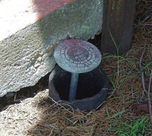
13 The NSRS has evolved 1 Million Monuments (Separate Horizontal and Vertical Systems) 70,000 Passive Marks (3-Dimensional) Passive Marks (Limited Knowledge of Stability) 2,000 GPS CORS (Time Dependent System Possible; 4-Dimensional) GPS CORS GNSS CORS
14 Historical Vertical Datums Sea Level Datum of 1929 NGVD29 National Geodetic Vertical Datum of 1929 NAVD88 North American Vertical Datum of 1988 PRVD02 Puerto Rico Vertical Datum ASVD02 American Samoa Vertical Datum NMVD03 Northern Marianas Vertical Datum VIVD09 Virgin Islands Vertical Datum 15


15 When was the passive mark last leveled? 16
16 Why Modernize? Evidence of systematic errors Decades of space geodetic observations All of the datums contain systematic errors (decimeters to meters) At scales larger than today s accuracy capabilities (centimeters) Origin (center of Earth) offset: 2+ meters Zero elevation surface: 0.5 to 2+ meters 17
17 What s Being Replaced? Horizontal Vertical NAD 83(2011) NAD 83(PA11) NAD 83(MA11) Latitude Longitude Ellipsoid Height State Plane Coordinates NAVD 88 PRVD 02 VIVD09 ASVD02 NMVD03 GUVD04 IGLD 85 Heights 18

18 The National Geodetic Survey 10 year plan Official NGS policy as of Jan 31, 2013 Updates 2008 plan Modernized and improve NSRS Attention to accuracy Attention to time-changes Improved products and services Fully vetted by NSPS/AAGS 2022 Targets: Replace NAD 83 and NAVD 88 Cm-accuracy access to all coordinates 19
19 NOMENCLATURE AND LEGISLATION 21
20 Nomenclature A chance to increase accuracy in naming! North American? Ignores Guam, Hawaii, American Samoa, Northern Mariana Islands Datum vs. Reference Frame? Plate-specific? Vertical vs. Geopotential? 6/8/2016: NGS and the Canadian Geodetic Survey (CGS) negotiated a naming proposal Approved by the NGS Executive Steering Committee Approved by the CGS leadership (with minor reservations) Early 2017 Approved by the Mexico s INEGI 22
21 (DRUM ROLL Please) 23
22 New Reference Frame Names NAD 83 becomes: North American Terrestrial Reference Frame (NATRF2022) Caribbean Terrestrial Reference Frame (CATRF2022) Mariana Terrestrial Reference Frame (MATRF2022) Pacific Terrestrial Reference Frame (PATRF2022) NAVD88 becomes: North American-Pacific Geopotential Datum of 2022 (NAPGD2022) (Realized by GEOID2022) 24
23 Legislation When NAD 83 replaced NAD 27, the Federal NSRS users were required to switch to NAD 83 Through the 1980s and 1990s NGS worked with the states to update their laws To encourage use of the new system beyond the feds 48 states now have laws that refer to NAD 83 by name A name which will be retired in
24 Legislation In 2016, NSPS, AAGS, and NGS formed a committee to address this issue The NSPS/AAGS/NGS Advisory Committee on National Spatial Reference System Legislation New Legislative Template completed June 2016 Generic terminology: NSRS or its successor, etc. NSPS will work with the states to adopt the new template between 2017 and
25 OBJECTIVE 1 OF 5: REPLACE NAD 83 27
26 Replace NAD 83 Simplified concept of NAD 83 vs Earth s Surface h NAD83 h 2022 φ NAD83 φ 2022 λ NAD83 λ 2022 h NAD83 h origin all vary smoothly by latitude and longitude NAD 83 origin 28

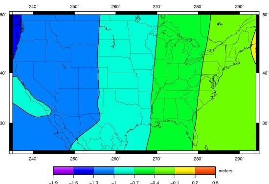
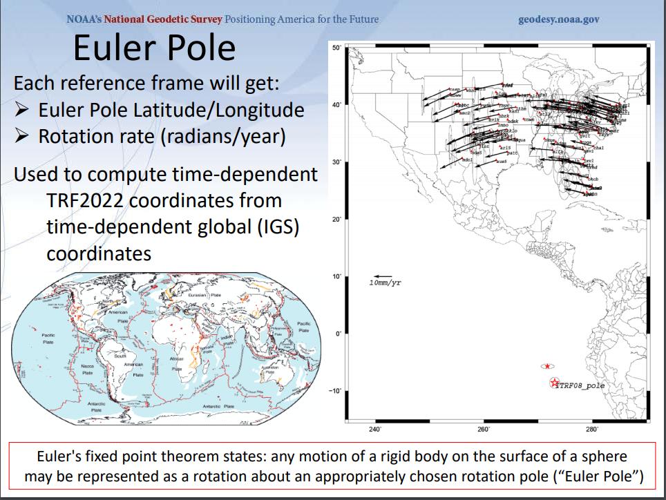
27 Horizontal Shifts Approximate IGS08(GRS-80) minus NAD 83(2011) Lat: Lon: 29

")
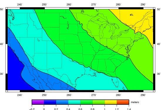
28 Ellipsoid Height Shifts Approximate IGS08(GRS-80) minus NAD 83(2011) 30


29 Replace NAD 83 Access and definition Primary: CORS Continuous monitoring IGS coordinates Transformable to any national reference frame chosen for 2022 OPUS Static Surveys RTK/RTN Validation service Secondary: Passive Time-tagged coordinates Will reflect each occupation of the mark Will generally not be accepted as fixed control in surveys turned in to NGS 31
30 More on: ITRF2008, IGS08 32
31 ITRF2008 For the geodesy, geophysics and surveying communities, the best International Terrestrial Reference Frame is the gold standard. The global community adopted an updated expression for the reference frame, the ITRF2008. (actually ITRF2014 published as of Jan2016) 33 33
32 International Earth Rotation and Reference System Service (IERS) ( The International Terrestrial Reference System (ITRS) constitutes a set of prescriptions and conventions together with the modeling required to define origin, scale, orientation and time evolution ITRS is realized by the International Terrestrial Reference Frame (ITRF) based upon estimated coordinates and velocities of a set of stations observed by: -Very Long Baseline Interferometry (VLBI), -Satellite Laser Ranging ( SLR), -Global Positioning System and GLONASS (GNSS), and -Doppler Orbitography and Radio- positioning Integrated by Satellite ( DORIS). ITRF89, ITRF90, ITRF91, ITRF92, ITRF93, ITRF94, ITRF95, ITRF96, ITRF97, ITRF2000, ITRF2005, ITRF2008, (ITRF2014) 34


")
")
")
33 International Terrestrial Reference Frame 4 Global Independent Positioning Technologies International Global Navigation Satellite Systems Service (IGS) International Laser Ranging Service (ILRS) International Very Long Baseline Service (IVS) International DORIS Service (IDS)
34 The IGS08 (ITRF- but GNSS only) The IGS has densified reference frame with much larger, global subset of GNSS tracking sites thereby creating a GNSS-only expression of the ITRF2008 called the IGS08. All IGS products have been recreated so as to be consistent with the IGS08 including GNSS ephemerides and antenna models. Information about the IGS08 can be found at the IGS web sites: igscb.jpl.nasa.gov. I would suggest starting with IGSMAIL 6354, 6355 and 6356, all dated
35 Enough International, Back to the New Datums 37
36 Definition of New Frames Plate fixed defined at an Epoch. Euler Pole Plate rotations will tie the new terrestrial reference frames of 2022 to the IGS frame Deformational velocities will be modeled separately 38
37 39
38 Time Dependencies Track CORS and always know where you are Surveying to CORS positions at survey epoch If we track CORS, we can do this easily Plate rotations Easily removed for a good east of the Rockies solution (Euler Pole Rotation for each plate s reference frame) Latitude/Longitude only Residual deformations Can be modeled many ways and provided for crossepoch checking between surveys (Inter-frame velocities models) 40

39 IGS Plate Velocities Horizontal Vertical IGS08 Velocities Baltimore County CORS BACO N = m/yr E = m/yr U = m/yr 41
40 OBJECTIVE 2 OF 5: REPLACE NAVD 88 42
41 Replace NAVD 88 Earth s Surface H (NAVD 88) H The Geoid Errors in NAVD 88: ~50 cm average, 100 cm CONUS tilt, 1-2 meters average in Alaska, NO tracking 43

42 Subsidence areas of the U.S. Source: U.S. Geological Survey 44

43 Replace NAVD 88 Changing from a leveling-based to a geoid/gnss-based vertical datum Biggest requirement: An updated, accurate, nationwide gravity survey Airborne GRAV-D! Gravity for the Redefinition of the American Vertical Datum 45
44 ELLIPSOID GEOID RELATIONSHIP H = Geopotential Orthometric Height (NAVD (NAPGD2022) 88) h = Ellipsoid Height (NAD 83 (2011)) N = Geoid Height (GEOID2022) (GEOID12B) H = h N H h N H h Geoid Average Mean Sea Level or NAVD 88 Surface N Geoid Model Ellipsoid GRS80 46
45 Transition to the Future GRAV-D Gravity for the Redefinition of the American Vertical Datum Official NGS policy as of Nov 14, 2007 $38.5M over 10 years Airborne Gravity Snapshot Absolute Gravity Tracking Re-define the Vertical Datum of the USA by

46 GRAV-D Coverage Alaska CONUS Guam/Northern Marianas Hawaii Puerto Rico/Virgin Islands American Samoa 48


47 GRAVITY AND GPS BASE STATIONS Parking spot ID Micro-G A10 Absolute Gravity measurement GPS Base Stations Vertical gravity gradient 49


48 GRAV-D AIRCRAFT INSTRUMENTATION Micro-g LaCoste TAGS Gravimeter NovAtel SPAN-SE w/ Honeywell µirs IMU Both instruments include GNSS receivers SPAN system allows for tightly coupled GPS/IMU solutions 50

49 SURVEY AND BLOCK PLANS Layout rectangular survey 400 x 500 km Extends beyond the shelf break Block size will reflect the endurance of the aircraft 51

50 SURVEY AND BLOCK PLANS Data lines spaced 10 km apart Cross lines spaced km apart Flight altitude 20,000 ft Nominal speed kts 52
 Launched 2009 53 Re-entered")
51 Space-Base Gravity Observations Gravity Recovery And Climate Experiment (GRACE) Launched Gravity field and steady state Ocean Circulation Explorer (GOCE) Launched Re-entered November, 2013


")
52 Building a model of the Earths Gravity Field Long Wavelengths: ( 400 km) GRACE & GOCE Satellites + Airborne Measurement Intermediate Wavelengths (500 km to 20 km) + Short Wavelengths (< 200 km) Surface Measurement 54

53 EXPERIMENTAL GEOIDS The gravity data from satellites, airborne, corrected surface data, and terrain predictions will be blended into a gravity field Methods for blending will be tested to prepare for 2022 Available on the Website 56

54 GRAV-D Status 50% mark hit in FY2016 FY2017 target: 62% Two planes at a time Occasionally three 100% by 2022 Mix of government and private industry collection 57

55 Orthometric Heights Approximate EXPECTED SHIFTS Approximate level of geoid mismatch known to exist in the NAVD 88 zero surface Does not include local subsidence issues 58

56 Time Dependencies Geoid changes cause height changes The zero elevation surface will change with time Heights will be time tagged to respect: Geoid change Subsidence 59
57 OBJECTIVE 3 OF 5: RE-INVENT BLUEBOOKING 60
 vertical (leveling) and gravity GPS surveys were force-fitted into the horizontal rules Reputation: Cumbersome To be fair: All industry standards are cumbersome it")
58 Bluebooking Refers to the blue cover of Input Formats and Specifications of the National Geodetic Survey Data Base The requirements for turning in a geodetic survey to NGS Very DOS/FORTRAN heavy Horizontal (angles, distances) vertical (leveling) and gravity GPS surveys were force-fitted into the horizontal rules Reputation: Cumbersome To be fair: All industry standards are cumbersome it prevents chaos 61

59 OPUS-Projects Or bluebooking for the 21 st century The 2013 Survey of the Washington Monument had GPS, leveling and traverse components. An integrated OPUS- Projects might allow for easier processing and especially cross-processing 62

60 OPUS-Projects Or bluebooking for the 21 st century 63
61 New Database Replacing the NGS IDB NGS IDB Integrated Database Current official repository of some (most?) NSRS data Integrated 2 old DBs: Horizontal / Vertical Built for Passive control No time dependencies Line of sight techniques Points NSRS DB Being built (target: 2020) Spatial database Time tags for everything Open design for any type of data Things that couldn t go into the IDB, but can go in the NSRS DB: Lines of airborne gravity LIDAR clouds CORS Superconducting Gravimeter data Etc. 64
62 OBJECTIVE 4 OF 5: IMPROVE THE TOOLKIT 65

63 NGS Toolkit A set of (mostly FORTRAN-based) geodetic tools Little integration Many with no online capability No web services 66

64 New Toolkit Datum transformations Convert to/from latitude and longitude State Plane Coordinates UTM US National Grid Upload file of points Web service Download and run offline 67
65 NADCON 5 Replacing NADCON 4.2 and GEOCON 2.0 Support for nearly all horizontal datums since 1897 Exceptions: Regional Alaska No state by state grids Fixing all existing bugs Web service Consistent Documented Rigorous location-dependent error estimates Ready to support
66 Toolkit Future The entire NGS Toolkit will be integrated eventually VERTCON 3.0 HTDP VDatum All other tools 72
67 OBJECTIVE 5 OF 5: BETTER SURVEYING 73

68 Better Surveying Overview A focus on updating technology and field procedures Field research 1997 New manuals
69 SUMMARY 76
70 Summary NSRS Modernization More than just replacing NAD 83 and NAVD 88 Affects most tools, products and services of NGS Dozens of interdependent, multi-year projects ongoing Expect rollouts and announcements throughout the next 6 years! 77

71 To Learn More Visit the New Datums web page geodesy.noaa.gov/datums/newdatums/index.shtml 78

72 To Learn More Geospatial Summit 79
73 Details: Blueprint documents Blueprint for 2022, Part 1: Geometric Coordinates A.K.A. NOAA Technical Report NOS NGS 62 (April 2017 release) Time-dependency Four terrestrial reference frames Intra-frame velocity models Blueprint for 2022, Part 2: Geopotential Coordinates A.K.A. NOAA Technical Report NOS NGS 64 (September 2017 release) Time-dependency One geopotential datum Interrelated global geopotential model, regional geoid grids, regional DoV grids, regional surface gravity grids 80
74 81
75 -Where are we now? -Where are we going? (2022 is already almost an hour closer!) QUESTIONS? 82
Overview of New Datums
 Overview of New Datums Scott Lokken NC Advisor NOAA s National Geodetic Survey 9/4/2015 1 New Datums are Coming in 2022! Both a new geometric and a new geopotential (vertical) datum will be released in
Overview of New Datums NOAA s National Geodetic Survey
 Overview of New Datums NOAA s National Geodetic Survey February 3, 2015 1 NGS s Mission and Role NGS Mission: To define, maintain, and provide access to the National Spatial Reference System to meet our
Determining Accurate Elevations: Datums & Tools, Today & Tomorrow
 Determining Accurate Elevations: Datums & Tools, Today & Tomorrow Maryland Association Floodplain and Stormwater Managers Linthicum Heights, MD Christine Gallagher Oct. 20, 2016 Overview NGS Mission Important
An NGS Illustrated Guide to Geodesy for GIS Professionals
 An NGS Illustrated Guide to Geodesy for GIS Professionals Michael Dennis, RLS, PE michael.dennis@noaa.gov Esri User Conference San Diego Convention Center July 14-18, 2014 San Diego, CA Why should we care
ELEMENTS OF THE NATIONAL SPATIAL REFERENCE SYSTEM
 Dave Doyle NGS Chief Geodetic Surveyor dave.doyle@noaa.gov 301-713-3178 ELEMENTS OF THE NATIONAL SPATIAL REFERENCE SYSTEM ESRI SURVEY SUMMIT San Diego, CA June 17, 2007 ftp://ftp.ngs.noaa.gov/dist/daved/esri
Determining Accurate Elevations: Datums & Tools, Today & Tomorrow
 Determining Accurate Elevations: Datums & Tools, Today & Tomorrow Association of State Floodplain Managers Annual Meeting Grand Rapids, MI Christine Gallagher June 21, 2016 Overview NGS Mission Important
Modernization of the National Spatial Reference System Keeping Pace with Changes in Positioning Technology and User Expectations in a Dynamic World
 Modernization of the National Spatial Reference System Keeping Pace with Changes in Positioning Technology and User Expectations in a Dynamic World Wisconsin Society of Land Surveyors Institute Wisconsin
Datums and Tools to Connect Geospatial Data Accurately
 Datums and Tools to Connect Geospatial Data Accurately Pamela Fromhertz Colorado State Geodetic Advisor National Geodetic Survey National Oceanic and Atmospheric Administration GIS-T April 18, 2012 Loveland,
BILL HENNING, Prof LS.
 BILL HENNING, Prof LS. DEFINITIONS: GEODESY, DATUMS, NSRS ACCESSING THE DATUM REALIZATION: PASSIVE MARKS, ACTIVE STATIONS WORLD SCIENTIFIC DATUMS HORIZONTAL, GEOMETRIC, VERTICAL, GRAVIMETRIC DATUMS IN
BILL HENNING, Prof LS. ACRONYMS
 BILL HENNING, Prof LS. ACRONYMS US 1 WIKIPEDIA: Also known as geodetics, geodetic engineering or geodetics engineering a branch of applied mathematics [2] and earth sciences, is the scientific discipline
Utilizing A GNSS Network Solution for Utility Applications
 Utilizing A GNSS Network Solution for Utility Applications David Newcomer, PE, PLS GPServ, Inc. newcomer@ (407) 601-5816 AGENDA Types and accuracies of data collection o Autonomous o Meter + o Sub-meter
High Precision GNSS for Mapping & GIS Professionals
 High Precision GNSS for Mapping & GIS Professionals Agenda Address your needs for GNSS knowledge. GNSS Basics Satellite Ranging Fundamentals (Code $ Carrier) Differential Corrections (Post Processed $
Datums for a Dynamic Earth
 Datums for a Dynamic Earth Based on a paper given at the American Society of Agricultural and Biological Engineers (ASABE) Conference in Reno, Nevada June 2009 Rollin StrohmanPh.D. Tom Mastin L.S Background
GNSS 101 Bringing It Down To Earth
 GNSS 101 Bringing It Down To Earth Steve Richter Frontier Precision, Inc. UTM County Coordinates NGVD 29 State Plane Datums Scale Factors Projections Session Agenda GNSS History & Basic Theory Coordinate
GPS Geodetic Reference System WGS 84
 GPS Geodetic Reference System WGS 84 International Committee on GNSS Working Group D Saint Petersburg, Russia 16 September 2009 Barbara Wiley National Geospatial-Intelligence Agency United States of America
Lecture 16 NAD 83 (1986), NAD 83(1993) and NAD 83 (NSRS 2007) 10 March 2009 GISC3325
, NAD 83(1993) and NAD 83 (NSRS 2007) 10 March 2009 GISC3325") Lecture 16 NAD 83 (1986), NAD 83(1993) and NAD 83 (NSRS 2007) 10 March 2009 GISC3325 Significant dates 16-20 March 2009 is Spring Break 12 March 2009 is Exam Two Emphasis on chapter 5, 6 and 8 of text
Lecture 16 NAD 83 (1986), NAD 83(1993) and NAD 83 (NSRS 2007) 10 March 2009 GISC3325 Significant dates 16-20 March 2009 is Spring Break 12 March 2009 is Exam Two Emphasis on chapter 5, 6 and 8 of text
Introduction to Datums James R. Clynch February 2006
 Introduction to Datums James R. Clynch February 2006 I. What Are Datums in Geodesy and Mapping? A datum is the traditional answer to the practical problem of making an accurate map. If you do not have
FieldGenius Technical Notes GPS Terminology
 FieldGenius Technical Notes GPS Terminology Almanac A set of Keplerian orbital parameters which allow the satellite positions to be predicted into the future. Ambiguity An integer value of the number of
Benefits and Impacts to Nautical Charting by Adopting a New Reference Frame. Dr. Neil Weston Office of Coast Survey, NOAA
 Benefits and Impacts to Nautical Charting by Adopting a New Reference Frame Dr. Neil Weston Office of Coast Survey, NOAA Motivation for this study NOAA s National Geodetic Survey New geometric reference
Lecture 14 NAD 83(NSRS), NAD 83(CORS 96), WGS84 and ITRF
, NAD 83(CORS 96), WGS84 and ITRF") Lecture 14 NAD 83(NSRS), NAD 83(CORS 96), WGS84 and ITRF Monday, March 1, 2010 2 March 2010 GISC3325 NAD 27 and NAD 83 NAD 27 and NAD 83 Versions of NAD 83 First implementation labeled NAD 83 (1986). Deficiencies
Lecture 14 NAD 83(NSRS), NAD 83(CORS 96), WGS84 and ITRF Monday, March 1, 2010 2 March 2010 GISC3325 NAD 27 and NAD 83 NAD 27 and NAD 83 Versions of NAD 83 First implementation labeled NAD 83 (1986). Deficiencies
The Global Positioning System II Field Experiments
 The Global Positioning System II Field Experiments 5-1 Mexico DGPS Field Campaign Cenotes in Tamaulipas, MX, near Aldama 5-2 Are Cenote Water Levels Related? 5-3 DGPS Static Survey of Cenote Water Levels
Understanding the Evolution of WGS 84 and NAD 83
 Summary Both WGS 84, the datum used by GPS,, commonly used in North America, have been redefined several times since their beginning. Parallel to this, there have also been several realizations of the
IAG School on Reference Systems June 7 June 12, 2010 Aegean University, Department of Geography Mytilene, Lesvos Island, Greece SCHOOL PROGRAM
 IAG School on Reference Systems June 7 June 12, 2010 Aegean University, Department of Geography Mytilene, Lesvos Island, Greece SCHOOL PROGRAM Monday June 7 8:00-9:00 Registration 9:00-10:00 Opening Session
The Global Positioning Sytem II 10/19/2017
 The Global Positioning System II Field Experiments 10/19/2017 5-1 Mexico DGPS Field Campaign Cenotes in Tamaulipas, MX, near Aldama 10/19/2017 5-2 Are Cenote Water Levels Related? 10/19/2017 5-3 M. Helper,
Geodesy, Geographic Datums & Coordinate Systems
 Geodesy, Geographic Datums & Coordinate Systems What is the shape of the earth? Why is it relevant for GIS? 1/23/2018 2-1 From Conceptual to Pragmatic Dividing a sphere into a stack of pancakes (latitude)
Lecture # 7 Coordinate systems and georeferencing
 Lecture # 7 Coordinate systems and georeferencing Coordinate Systems Coordinate reference on a plane Coordinate reference on a sphere Coordinate reference on a plane Coordinates are a convenient way of
WISCONSIN COORDINATE SYSTEMS
 Pdf versions of the Handout and Powerpoint slides are on jerrymahun.com. Follow the USPLSS Forum link and use the password: WildT2 WISCONSIN COORDINATE SYSTEMS CONCEPTS & IMPLEMENTATION Jerry Mahun, PLS,
Datum Transformations: Nightmare on GIS Street. Agenda
 Datum Transformations: Nightmare on GIS Street Speaker: Eric Gakstatter Contributing Editor GPS World Editor - Geospatial Solutions Presented at: Minnesota Society of Professional Surveyors Bloomington,
Appendix A Lower Columbia River Chart Datum Modeling
 Appendix A Lower Columbia River Chart Datum Modeling David Evans and Associates, Inc. David Evans and Associates, Inc. 2801 SE Columbia Way, Ste. 130 Vancouver, WA 98661 (360) 314-3200 1.0 Vertical Datum
GLOBAL POSITIONING SYSTEMS
 GLOBAL POSITIONING SYSTEMS GPS & GIS Fall 2017 Global Positioning Systems GPS is a general term for the navigation system consisting of 24-32 satellites orbiting the Earth, broadcasting data that allows
DYNAMIC RT TECHNOLOGY
 DYNAMIC RT TECHNOLOGY GLOBAL NAVIGATION SATELLITE SYSTEMS (GNSS) POTENTIAL FUTURE DEVELOPMENTS(2005 2017?) GPS MODERNIZATION BLOCK IIF & III GLONASS ENHANCEMENTS (K & M) EUROPEAN UNION - GALILEO CHINA
GPS for. Land Surveyors. Jan Van Sickle. Fourth Edition. CRC Press. Taylor & Francis Group. Taylor & Francis Croup, an Informa business
 GPS for Land Surveyors Fourth Edition Jan Van Sickle CRC Press Taylor & Francis Group Boca Raton London New York CRC Press is an imprint of the Taylor & Francis Croup, an Informa business Contents Preface
GNSS & Coordinate Systems
 GNSS & Coordinate Systems Matthew McAdam, Marcelo Santos University of New Brunswick, Department of Geodesy and Geomatics Engineering, Fredericton, NB May 29, 2012 Santos, 2004 msantos@unb.ca 1 GNSS GNSS
LAB PROCEDURES: TOPCON TOOLS FAMILIARIZATION
 LAB PROCEDURES: TOPCON TOOLS FAMILIARIZATION This lab will cover the basic setup and processing options of Topcon Tools (TT). We will learn how to start a project, upload data and control files, set up
Using GPS to Establish the NAVD88 Elevation on Reilly The A-order HARN Station at NMSU
 Using GPS to Establish the NAVD88 Elevation on Reilly The A-order HARN Station at NMSU Earl F. Burkholder, PS, PE New Mexico State University Las Cruces, NM 88003 July 005 Introduction GPS has become an
Development of Geoid Based Vertical Datums, A New Zealand Perspective
 Technical Seminar Reference Frame in Practice, Development of Geoid Based Vertical Datums, A New Zealand Perspective Matt Amos Manager Positioning and Innovation Land Information New Zealand Sponsors:
Coordinates, Datums, and Map Projection
 Coordinates, Datums, and Map Projection Two views on the World Intersect at 90 o angles Latitude/ Longitude is a Spherical System Acceptable latitudes/longitudes i) W125 o 27 33 ii) N92 o 45 12 iii)
Application of GPS/GNSS in Cybermapping. Cybermapping Lab University of Texas at Dallas 2009
 Application of GPS/GNSS in Cybermapping Cybermapping Lab University of Texas at Dallas 2009 GNSS Global Navigation Satellite System (GNSS) is the standard generic term for satellite navigation systems
GPS and GNSS from the International Geosciences Perspective
 GPS and GNSS from the International Geosciences Perspective G. Beutler Astronomical Institute, University of Bern Member of IAG Executive Committee and of IGS Governing Board National Space-Based Positioning,
National Height Modernization: Cost comparison of conducting a vertical survey by leveling versus by GPS in western North Carolina
 Introduction: National Height Modernization: Cost comparison of conducting a vertical survey by leveling versus by GPS in western North Carolina The North Carolina Geodetic Survey (NCGS) conducted a National
Applications, Products and Services of GPS Technology
 Applications, Products and Services of GPS Technology Enrico C. Paringit. Dr. Eng. University of the Philippines Training Center for Applied Geodesy and Photogrammetry 1 Outline of this Presentation GPS
Global Positioning Systems - GPS
 Global Positioning Systems - GPS GPS Why? What is it? How does it work? Differential GPS How can it help me? GPS Why?? Where am I? How do I get there? Where are you, and how do I get to You? WHO CARES???
What makes the positioning infrastructure work. Simon Kwok Chairman, Land Surveying Division Hong Kong Institute of Surveyors
 What makes the positioning infrastructure work The experience of the Hong Kong Satellite Positioning Reference Station Network Simon Kwok Chairman, Land Surveying Division Hong Kong Institute of Surveyors
Who s heard of the GDA2020?
 Implications of a next generation datum in Australia on mining operations: A discussion. School of Civil & Environmental Engineering Craig Roberts Senior lecturer Surveying and Geospatial Engineering group
Global Positioning Systems -GPS
 Global Positioning Systems -GPS GPS Why? What is it? How does it work? Differential GPS How can it help me? GPS Why?? Where am I? How do I get there? Where are you, and how do I get to You? WHO CARES???
Standard for the Australian Survey Control Network
 Standard for the Australian Survey Control Network Special Publication 1 Intergovernmental Committee on Survey and Mapping (ICSM) Geodesy Technical Sub-Committee (GTSC) 30 March 2012 Table of contents
The realization of a 3D Reference System
 The realization of a 3D Reference System Standard techniques: topographic surveying and GNSS Observe angles and distances either between points on the Earth surface or to satellites and stars. Do not observe
Standard for New Zealand Vertical Datum 2016 LINZS25009
 Standard for New Zealand Vertical Datum 2016 LINZS25009 Effective Date: 27 June 2016 Table of Contents TERMS ND DEFINITIONS... 3 FOREWORD... 5 INTRODUCTION... 5 PURPOSE OF STNDRD... 5 BRIEF HISTORY OF
21st International Conference of The Coastal Society
 21st International Conference of The Coastal Society DEVELOPMENT OF A VERTICAL DATUM TRANSFORMATION TOOL AND A BATHYMETRIC/TOPOGRAPHIC DIGITAL ELEVATION MODEL FOR SOUTHERN CALIFORNIA Edward P. Myers, NOAA/NOS
Other Space Geodetic Techniques. E. Calais Purdue University - EAS Department Civil 3273
 Other Space Geodetic Techniques E. Calais Purdue University - EAS Department Civil 3273 ecalais@purdue.edu Satellite Laser Ranging = SLR Measurement of distance (=range) between a ground station and a
Other Space Geodetic Techniques. E. Calais Purdue University - EAS Department Civil 3273
 Other Space Geodetic Techniques E. Calais Purdue University - EAS Department Civil 3273 ecalais@purdue.edu Satellite Laser Ranging Measurement of distance (=range) between a ground station and a satellite
The Global Positioning System II Field Experiments. 10/10/2013 GEO327G/386G, UT Austin 5-1
 The Global Positioning System II Field Experiments 10/10/2013 GEO327G/386G, UT Austin 5-1 Mexico DGPS Field Campaign Cenotes in Tamaulipas, MX, near Aldama 10/10/2013 GEO327G/386G, UT Austin 5-2 Are Cenote
A NEW GEOCENTRIC DATUM FOR NEW ZEALAND
 A NEW GEOCENTRIC DATUM FOR NEW ZEALAND Don Grant Graeme Blick Office of Surveyor-General Land Information New Zealand PO Box 5501 Wellington New Zealand Phone 04 4600100 Fax 04 4722244 dgrant@linz.govt.nz
Satellite Laser Retroreflectors for GNSS Satellites: ILRS Standard
 Satellite Laser Retroreflectors for GNSS Satellites: ILRS Standard Michael Pearlman Director Central Bureau International Laser Ranging Service Harvard-Smithsonian Center for Astrophysics Cambridge MA
GNSS Technology Update
 GNSS Technology Update Speaker: Eric Gakstatter Contributing Editor GPS World Editor - Geospatial Solutions Presented at: Association of Petroleum Surveying & Geomatics Houston, TX April 7, 2015 Agenda
LiDAR Remote Sensing Data Collection Department of Geology and Mineral Industries Mt. Shasta Study Area February 2, 2011
 LLiiD DA AR RR Reem moottee SSeennssiinngg D Daattaa C Coolllleeccttiioonn D Deeppaarrttm meenntt ooff G Geeoollooggyy aanndd M Miinneerraall IInndduussttrriieess M Mtt.. SShhaassttaa SSttuuddyy A Arreeaa
Chapter 6 GPS Relative Positioning Determination Concepts
 Chapter 6 GPS Relative Positioning Determination Concepts 6-1. General Absolute positioning, as discussed earlier, will not provide the accuracies needed for most USACE control projects due to existing
Beginners Guide to GPS Elevation Plus an Update on GPS Technology
 Beginners Guide to GPS Elevation Plus an Update on GPS Technology A TMS Presentation By: Jon Aschenbach Summerlake Enterprises 919 36 th Place Forest Grove, OR 97116 503-707-6236 Coeur d Alene, ID April,
VERTICAL DATUM TRANSFORMATIONS FOR KINEMATIC GPS HYDROGRAPHIC SURVEYS. Kurt W. Hess, Dennis G. Milbert, Stephen K. Gill, and Daniel R.
 VERTICAL DATUM TRANSFORMATIONS FOR KINEMATIC GPS HYDROGRAPHIC SURVEYS Kurt W. Hess, Dennis G. Milbert, Stephen K. Gill, and Daniel R. Roman National Ocean Service, NOAA ABSTRACT Kinematic Global Positioning
Geodetic Positioning Refresher
 Geodetic Positioning Refresher by Joan Yau PhD ABCLS AGM 2016, Kimberley BC Contents Horizontal / Vertical Datums and Epochs used in BC and Canada How do we reference our project coordinates to BC datums
GPS Technical Aspects
 GPS Technical Aspects Charles Ghilani (cghilani@psu.edu) Turn off all cell phones Or set them to vibrate Class Etiquette Ask questions at any point during the class. Simply speak up so that all can hear
Progress Towards the Seamless Combination of Bathymetric and Topographic Data in New Zealand
 Progress Towards the Seamless Combination of Bathymetric and Topographic Data in New Zealand Matt Amos Senior Technical Advisor National Geodetic Office Introduction Datasets usually defined in terms of
GROUND CONTROL SURVEY REPORT
 GROUND CONTROL SURVEY REPORT Services provided by: 3001, INC. a Northrop Grumman company 10300 Eaton Place Suite 340 Fairfax, VA 22030 Ground Control Survey in Support of Topographic LIDAR, RGB Imagery
Choosing the best path:
 GEODESY Choosing the best path: Global to national coordinate transformations The paper demonstrates that differences of up to a few centimetres in each coordinate component can occur depending on the
Geodetic policy for Ireland and Northern Ireland
 Geodetic policy for Ireland and Northern Ireland Background Ordnance Survey Ireland (OSi) is the National Mapping Agency (NMA) of the Republic of Ireland. The Ordnance Survey of Northern Ireland (OSNI)
Global IGS/GPS Contribution to ITRF
 Global IGS/GPS Contribution to ITRF R. Ferland Natural ResourcesCanada, Geodetic Survey Divin 46-61 Booth Street, Ottawa, Ontario, Canada. Tel: 1-613-99-42; Fax: 1-613-99-321. e-mail: ferland@geod.nrcan.gc.ca;
The Promise and Challenges of Accurate Low Latency GNSS for Environmental Monitoring and Response
 Technical Seminar Reference Frame in Practice, The Promise and Challenges of Accurate Low Latency GNSS for Environmental Monitoring and Response John LaBrecque Geohazards Focus Area Global Geodetic Observing
Definition and use of the New Zealand Vertical Datum Matt Amos Senior Advisor Geodesy
 Definition and use of the New Zealand Vertical Datum 2009 Matt Amos Senior Advisor Geodesy NZIS Continuing Professional Development Programme, November 2009 Overview Height Theory Heights in New Zealand
CHAPTER 2 GEODESY AND DATUMS IN NAVIGATION
 CHAPTER 2 GEODESY AND DATUMS IN NAVIGATION GEODESY, THE BASIS OF CARTOGRAPHY 200. Definition Geodesy is the application of mathematics to model the size and shape of the physical earth, enabling us to
9/26/2016. Accuracy with GNSS What are you getting? Presented By Tom Bryant PLS Kelly Harris PLS Seiler Instrument
 Accuracy with GNSS What are you getting? Presented By Tom Bryant PLS Kelly Harris PLS Seiler Instrument 1 What We Will Talk About Today What coordinate system should I use in my data collector Site Calibrations-what
AUSPOS GPS Processing Report
 AUSPOS GPS Processing Report February 13, 2012 This document is a report of the GPS data processing undertaken by the AUSPOS Online GPS Processing Service (version: AUSPOS 2.02). The AUSPOS Online GPS
U.S. Army Corps of Engineers: Review of Progress Toward Consistent Vertical Datums. by Jim Garster and Mark Huber
 U.S. Army Corps of Engineers: Review of Progress Toward Consistent Vertical Datums by Jim Garster and Mark Huber i ii Abstract A vertical datum is the most important part of any geospatial data, no matter
Trimble Business Center:
 Trimble Business Center: Modernized Approaches for GNSS Baseline Processing Trimble s industry-leading software includes a new dedicated processor for static baselines. The software features dynamic selection
OLC Turnbull. wsidata.com
 OLC Turnbull wsidata.com August 26, 2013 Base station set up over control TURN_03 Data collected for: Department of Geology and Mineral Industries 800 NE Oregon Street Suite 965 Portland, OR 97232 Prepared
DGFI reference frame solution as contribution to ITRF2008
 COST Action: ES0701, Vienna, Austria, November 16-17, 2010 WG2: Velocity determination / reference frame realization DGFI reference frame solution as contribution to ITRF2008 D. Angermann, M. Seitz, H.
Joining New Zealand Land and Sea Vertical Datums (JLAS) Graeme Blick Group Manager Positioning and Resilience
 Graeme Blick Group Manager Positioning and Resilience") Presented at the FIG Congress 2018, May 6-11, 2018 in Istanbul, Turkey Joining New Zealand Land and Sea Vertical Datums (JLAS) Graeme Blick Group Manager Positioning and Resilience Mapping NZ 2025 What
Presented at the FIG Congress 2018, May 6-11, 2018 in Istanbul, Turkey Joining New Zealand Land and Sea Vertical Datums (JLAS) Graeme Blick Group Manager Positioning and Resilience Mapping NZ 2025 What
Connecting a Survey to PNG94 and MSL using GNSS
 45th Association of Surveyors PNG Congress, Madang, 19-22 July 2011 Connecting a Survey to PNG94 and MSL using GNSS Richard Stanaway QUICKCLOSE Workshop overview Legal requirements to connect surveys to
Connecting a Cadastral Survey to PNG94 using GNSS
 43rd Association of Surveyors PNG Congress, Lae, 12th-15th August 2009 Connecting a Cadastral Survey to PNG94 using GNSS Richard Stanaway QUICKCLOSE Workshop overview Legal requirements to connect surveys
Record 2013/01 GeoCat 75057
 Record 2013/01 GeoCat 75057 Determination of GDA94 coordinates for station CCMB at the Clermont Coal Mine of Rio Tinto Coal Australia (RTCA) in central Queensland using the October and November 2012 GPS
Overview of Recent Tidal Projects in the United States
 1 st Tides and Water Levels Working Group Meeting Overview of Recent Tidal Projects in the United States Stephen Gill National Oceanic and Atmospheric Administration, National Ocean Service Center for
Record 2013/06 GeoCat 75084
 Record 2013/06 GeoCat 75084 Determination of GDA94 coordinates for station CAVL at the Caval Ridge Mine of RPS Australia East Pty Ltd in Queensland using the November 2012 GPS data set G. Hu, J. Dawson
NATIONAL VDATUM -- THE IMPLEMENTATION OF A NATIONAL VERTICAL DATUM TRANSFORMATION DATABASE
 NATIONAL VDATUM -- THE IMPLEMENTATION OF A NATIONAL VERTICAL DATUM TRANSFORMATION DATABASE Bruce Parker, Dennis Milbert, Kurt Hess, and Stephen Gill National Ocean Service, NOAA The National Ocean Service
Guidelines for Laying Targets for Ground Control Points
 Guidelines for Laying Targets for Ground Control Points Overview of target requirements: Three to four unambiguous ground survey targets, recognizable in the satellite photo, are requested. The survey
Update on the International Terrestrial Reference Frame (ITRF)
") Update on the International Terrestrial Reference Frame (ITRF) Zuheir Altamimi Head of the IERS ITRF Product Center Institut National de l Information Géographique et Forestière IGN, France E-mail: zuheir.altamimi@ign.fr
Update on the International Terrestrial Reference Frame (ITRF) Zuheir Altamimi Head of the IERS ITRF Product Center Institut National de l Information Géographique et Forestière IGN, France E-mail: zuheir.altamimi@ign.fr
CO-LOCATION: GUIDING PRINCIPLE OF THE DORIS DEPLOYMENT
 CO-LOCATION: GUIDING PRINCIPLE OF THE DORIS DEPLOYMENT IDS WORKSHOP 2016 Jérôme Saunier 1, Zuheir Altamimi 1, Xavier Collilieux 1, Bruno Garayt 1, Médéric Gravelle 2, Jean-Claude Poyard 1 1 IGN France
Principles of the Global Positioning System Lecture 19
 12.540 Principles of the Global Positioning System Lecture 19 Prof. Thomas Herring http://geoweb.mit.edu/~tah/12.540 GPS Models and processing Summary: Finish up modeling aspects Rank deficiencies Processing
Global Positioning Systems (GPS) Trails: the achilles heel of mapping from the air / satellites
 Trails: the achilles heel of mapping from the air / satellites") Global Positioning Systems (GPS) Trails: the achilles heel of mapping from the air / satellites Google maps updated regularly by local users using GPS Also: http://openstreetmaps.org GPS applications
Global Positioning Systems (GPS) Trails: the achilles heel of mapping from the air / satellites Google maps updated regularly by local users using GPS Also: http://openstreetmaps.org GPS applications
GLOBAL NAVIGATION SATELLITE SYSTEMS (GNSS) ECE 2526E Tuesday, 24 April 2018
 ECE 2526E Tuesday, 24 April 2018") GLOBAL NAVIGATION SATELLITE SYSTEMS (GNSS) ECE 2526E Tuesday, 24 April 2018 MAJOR GLOBAL NAVIGATION SATELLITE SYSTEMS (GNSS) Global Navigation Satellite System (GNSS) includes: 1. Global Position System
GLOBAL NAVIGATION SATELLITE SYSTEMS (GNSS) ECE 2526E Tuesday, 24 April 2018 MAJOR GLOBAL NAVIGATION SATELLITE SYSTEMS (GNSS) Global Navigation Satellite System (GNSS) includes: 1. Global Position System
GPS and Recent Alternatives for Localisation. Dr. Thierry Peynot Australian Centre for Field Robotics The University of Sydney
 GPS and Recent Alternatives for Localisation Dr. Thierry Peynot Australian Centre for Field Robotics The University of Sydney Global Positioning System (GPS) All-weather and continuous signal system designed
The International Scene: How Precise Positioning Will Underpin Critical GNSS Applications
 The International Scene: How Precise Positioning Will Underpin Critical GNSS Applications School of Civil & Environmental Engineering, UNSW, Sydney, Australia Chris Rizos Member of the IGS Governing Board
Where Next for GNSS?
 Where Next for GNSS? Professor Terry Moore Professor of Satellite Navigation Nottingham The University of Nottingham Where Next for GNSS Back to the Future? Professor Terry Moore Professor of Satellite
LSD PQSL Series Geodetic Survey. Prepared by Mr KWOK King-hung 22 May 2015
 LSD PQSL Series 2015 Geodetic Survey Prepared by Mr KWOK King-hung 22 May 2015 1 Geodesy Source from Wiki May 2015 also known as geodetics or geodetics engineering a branch of applied mathematics and earth
VLBI and DDOR activities at ESOC
 VLBI and DDOR activities at ESOC Claudia Flohrer 1, Mattia Mercolino 2, Erik Schönemann 1, Tim Springer 1, Joachim Feltens 1, René Zandbergen 1, Werner Enderle 1, Trevor Morley 3 1) Navigation Support
Introduction to Geographic Information Science. Last Lecture. Today s Outline. Geography 4103 / GNSS/GPS Technology
 Geography 4103 / 5103 Introduction to Geographic Information Science GNSS/GPS Technology Last Lecture Geoids Ellipsoid Datum Projection Basics Today s Outline GNSS technology How satellite based navigation
TECHNICAL REPORT NO. 45 TECHNICAL REVIEW AND REEVALUATION OF THE REGIONAL CONTROL SURVEY PROGRAM IN SOUTHEASTERN WISCONSIN
 TECHNICAL REPORT NO. 45 TECHNICAL REVIEW AND REEVALUATION OF THE REGIONAL CONTROL SURVEY PROGRAM IN SOUTHEASTERN WISCONSIN SOUTHEASTERN WISCONSIN REGIONAL PLANNING COMMISSION SOUTHEASTERN WISCONSIN REGIONAL
Philippine Geodetic Infrastructure Status, Challenges and Future Direction
 Philippine Geodetic Infrastructure Status, Challenges and Future Direction Engr. Charisma Victoria D. Cayapan National Mapping and Resource Information Authority PHILIPPINES Outline Evolution of Geodetic
GPS STATIC-PPP POSITIONING ACCURACY VARIATION WITH OBSERVATION RECORDING INTERVAL FOR HYDROGRAPHIC APPLICATIONS (ASWAN, EGYPT)
") GPS STATIC-PPP POSITIONING ACCURACY VARIATION WITH OBSERVATION RECORDING INTERVAL FOR HYDROGRAPHIC APPLICATIONS (ASWAN, EGYPT) Ashraf Farah Associate Professor,College of Engineering, Aswan University,
GPS STATIC-PPP POSITIONING ACCURACY VARIATION WITH OBSERVATION RECORDING INTERVAL FOR HYDROGRAPHIC APPLICATIONS (ASWAN, EGYPT) Ashraf Farah Associate Professor,College of Engineering, Aswan University,
Record 2012/76 GeoCat 74975
 Record 2012/76 GeoCat 74975 Determination of GDA94 coordinates for station GRBA at the Goonyella Riverside Mine of the BHP Billiton Mitsubishi Alliance (BMA) in central Queensland using the September and
- 1 - Conduct aerial gravity survey countrywide for height component of the geodetic network. Draft report. submitted to
 - 1 - Conduct aerial gravity survey countrywide for height component of the geodetic network Draft report submitted to Ministry of Lands Housing and Human Settlements Development Kivukoni Waterfront Dar
CGG. Office of the Surveyor General of the Federation Federal Capital Territory, Abuja, Nigeria 2
 Prof. P. C. Nwilo 1, * Dr. J. D. Dodo 2, U. R. Edozie 1, and A. Adebomehin 1. 1 Office of the Surveyor General of the Federation Federal Capital Territory, Abuja, Nigeria 2 Centre for Geodesy and Geodynamics,