The International Scene: How Precise Positioning Will Underpin Critical GNSS Applications
|
|
|
- Shon Parker
- 6 years ago
- Views:
Transcription
 President International Association of Geodesy")
1 The International Scene: How Precise Positioning Will Underpin Critical GNSS Applications School of Civil & Environmental Engineering, UNSW, Sydney, Australia Chris Rizos Member of the IGS Governing Board ( ) President International Association of Geodesy ( )
2 Diversity of Precise Positioning applications... 1cm 2cm < dm 1dm Scientific geodesy Datum Deformation surveys Machine automation Surveying Engineering & construction Sensor georeferencing Precision agriculture LEO POD Advanced ITS Mapping & Hydrography Offshore engineering Disaster response
3 Diversity of Precise Positioning applications... 1cm 2cm < dm 1dm Scientific geodesy Datum Deformation surveys Machine automation Sensor georeferencing Precision agriculture Although there is a wide range of Surveying user equipment, services & Engineering & operational construction procedures, most use the relative positioning method... Advanced ITS LEO POD Mapping & Hydrography Offshore engineering Disaster response
 DGNSS corrs or raw data")
4 Relative Positioning (Differential GPS)... GPS satellites Local base station(s) DGNSS corrs or raw data Real-time or postmission GPS user
5 Comments to Precise Positioning differential has been dominant PP mode since 1980s... mitigates impact or orbit, satellite clock & atmospheric errors... base or reference station(s) needed... increasingly evolving to CORS infrastructure... raw data or corrections increasingly from Service Providers... real-time or post-survey mode... short baselines commercial/typical implementation... long baselines scientific/datum applications
6 Global/Regional/National GNSS Networks
7 Global/Regional/National GNSS Networks
8 Commercial operations Short baselines, high productivity Base stn data Surveying, mapping, precise navigation, etc Science applications Long baselines/network precise positioning Base stn data, precise orbits Geodesy, geoscience, etc
9 Commercial operations Support... Precise Positioning users National or project datum Science applications Support... Geodesy, geoscience, etc International Services data & products Global or project datum


10 GLOBAL, LONG-TERM REFERENCE FRAME Commercial operations Short baselines, high productivity Precise Positioning users National or project datum In Science applications International Services data, products & infrastructure Long baselines/network, precise positioning Geodesy, geoscience, etc Global or project datum Connection to datum
11 International Services & Infrastructure underpin Precise Positioning... Global Geodetic Reference Frame: International Earth Rotation & Reference Systems Service (IERS) Integrated outputs of multiple space geodetic techniques Definition & maintenance of International Terrestrial Reference Frame (ITRF) ITRF recognised as the highest fidelity global datum Global GNSS data & products: International GNSS Service (IGS) Global GNSS tracking (base stn) network Raw base stn data & derived high quality orbit & clock products freely available to all users The gold standard GNSS services & expertise

12 ? 1.1 Without a geodetic framework...???
 is a Reference Frame defined at national or international level All modern")
: Crustal motion Origin, Scale & Orientation Local")
13 1.2 The ITRF: the modern GGRF... What links isolated GNSS (& other surveys) is a Reference Frame defined at national or international level All modern national datums directly (or indirectly) aligned with ITRF; recognised the best GGRF All points, objects, geodetic control marks, GNSS CORS on the surface of the Earth move (4-D coordinates): Crustal motion Origin, Scale & Orientation Local deformation Ground subsidence or inflation etc It is now easy to link to the ITRF using GNSS techniques

14 2.2 International GNSS Service... IGS is an IAG service established in 1994 IGS is a voluntary federation more than 200 worldwide agencies in more than 90 countries that pool resources and permanent GNSS station data to generate precise IGS products IGS operates on a best efforts basis though with considerable redundancy IGS products are combinations of independent results from several ACs Improvements in signals, receivers and computations have led to continuous improvements in product quality Geospatial applications & earth science missions rely upon IGS products IGS launched in 2011 a Multi-GNSS Experiment IGS launched in 2013 a Real-Time Service

15 2.1 The IGS tracking network... ~450 stations ~150 real-time ~100 multi-gnss
16 2.3 The IGS Products... Primary products global raw IGS receiver tracking data GPS and GLONASS orbits station coords, contribute to: definition & densification of ITRF Related products clock corrections for satellites and IGS stations earth rotation parameters global ionosphere maps IGS station troposphere parameters standards & formats (site guidelines, RINEX, SINEX, IONEX, RTCM...) GNSS system monitoring (constellation status, DCB, )
17 Precise Positioning... some crystal ball gazing... non-differential PP techniques emerge... adoption of ITRF-based datums... transition from GPS-only to multi-constellation GNSS... real-time operations the norm, including for science... PP applications set for rapid growth... commercial PPP services, & other PP services... open standards & data formats... wider variety of PP hardware options, including non-gnss solutions... an increased role for international services such as IERS & IGS

 GLONASS")
")
 (35)")
 IRNSS")


18 From GPS to multi-gnss + GNSS: GPS (30) (32) GLONASS (24) (30) Galileo (4) (30) BeiDou (14) (35) RNSS: QZSS (1) (5-7) IRNSS (2) (7) SBAS: WAAS MSAS EGNOS GAGAN SDCM Number of satellites: (Current) (Planned)


19 Some benefits of PP GNSS in Australia 2008 study found productivity gains with potential cumulative benefit $73B to $134B over period of 20 years in agriculture, construction and mining alone Additional cumulative economic benefit $32B to $58B from a coordinated rollout of NPI Also, significant environmental benefits, such as reduced carbon footprint through improved fuel efficiency Market uptake in A-C-M still comparatively low, with new apps looming Economic benefits of high resolution positioning services, Allens Consulting Group, for CRC-SI & Vic. DSE, Nov 2008, download:


20 Advanced ITS PP applications... Positioning in vehicles is going from Passive to Active... from simple navigation to information about traffic to warnings about hazards to actively avoiding hazards... current local GNSS solutions inadequate...
21 Precise Point Positioning (PPP) GNSS constellation(s) CORS network GNSS user Infrastructureless? Or less CORS infrastructure? What has happened to the datum? Precise GNSS satellite orbit & clock corrections Real-time or post-processed? Commercial or free services? PPP or PPP-RTK?
 CORS network Less infrastructure Local CORS network GNSS user Precise GNSS")
22 Augmented PPP: PPP-RTK? GNSS constellation(s) CORS network Less infrastructure Local CORS network GNSS user Precise GNSS satellite orbit & clock corrections What has happened to the datum? Measurement biases

23 Commercial PPP services...

24 Free PPP via RT-IGS...

25 RTS IGS01/IGC01 products

26 RTS IGS01/IGC01 products

27 RTS IGS01... PPP Results Frankfurt a.m. SIS-UERE at decimetre-level

28 RTS IGS03... PPP results Frankfurt a.m. SIS-UERE at decimetre-level

29 A sign of things to come... RT-PPP enabled by geodetic services & OEM components GPS OEM + Open Source RTKLIB + Internet + RT-IGS = Low-cost RT-PPP

30 A sign of things to come... mass market PPP enabled by smartphone-type receivers, taking advantage of geodetic services
31 IGS in the future... High quality GPS/GLONASS network and products High quality multi-gnss network and products MGEX Build-up and share multi-gnss know-how Build-up network and provide access to multi-gnss data Develop prototype multi-gnss products Develop recommendations and standards Engage with receiver manufacturers and system providers RTS GPS PP Transition Merge legacy and multi- GNSS networks Achieve interoperability of legacy and multi-gnss products and services RTS GPS+ GLONASS Multi-GNSS Pilot Service Incorporate BeiDou, Galileo, and QZSS into standard IGS processing Issue combined and quality controlled multi-gnss IGS orbit, clock and iono products Regular multi-gnss intersystem, interfrequency and intersignal bias estimation Link GNSS system times with IGS system time Embed new GNSSs into IGS/IAG reference frames RTS for multi-gnss
32 Final remarks... Trends in the international scene impacting on PP use of ITRF-based national datums... increasing number of GNSS satellites & signals... increasing use of PPP-based techniques, hence global datum... global & regional services to support PP, commercial & free... increasing range of IGS products to support PP... mass market PP applications... global standards & formats, user requirements & solutions... increasing recognition of importance of Precise Positioning
Real-Time and Multi-GNSS Key Projects of the International GNSS Service
 Real-Time and Multi-GNSS Key Projects of the International GNSS Service Urs Hugentobler, Chris Rizos, Mark Caissy, Georg Weber, Oliver Montenbruck, Ruth Neilan EUREF 2013 Symposium Budapest, Hungary, May
Precise Positioning... what does it mean? Precise GNSS Positioning Not just a niche technology. Chris Rizos 15/12/15
 Precise GNSS Positioning Not just a niche technology Chris Rizos Precise Positioning... what does it mean? 1 Precise Positioning... a spectrum of users... Few mm 1cm 2cm < dm 1dm sub-m Precision agriculture
Precise Positioning GNSS Applications
 Precise Point Positioning: Is the Era of Differential GNSS Positioning Drawing to an End? School of Surveying & Spatial Information Systems, UNSW, Sydney, Australia Chris Rizos 1, Volker Janssen 2, Craig
Multi-GNSS Environment. Chris Rizos UNSW, Australia President IAG
 Multi-GNSS Environment Chris Rizos UNSW, Australia President IAG Visit official GNSS web sites: GPS - www.navcen.uscg.gov & www.gps.gov GLONASS - glonass-ianc.rsa.ru/en/ Galileo - www.esa.int/our_activities/navigation
GNSS Technology Update
 GNSS Technology Update Speaker: Eric Gakstatter Contributing Editor GPS World Editor - Geospatial Solutions Presented at: Association of Petroleum Surveying & Geomatics Houston, TX April 7, 2015 Agenda
Geoscience & Positioning, Navigation and Timing Services for Canadians
 Geoscience & Positioning, Navigation and Timing Services for Canadians Calvin Klatt, Ph.D. Director and Chief Geodesist Natural Resources Canada / Directeur et géodésien principal Ressources naturelles
Compact multi-gnss PPP corrections messages for transmission through a 250 bps channel
 Compact multi-gnss PPP corrections messages for transmission through a 250 bps channel Ken Harima, School of Science, RMIT University Suelynn Choy, School of Science, RMIT University Chris Rizos, School
Quasi-Zenith Satellite System (QZSS)
") Transmission of Augmentation Corrections using the Japanese QZSS for Real-Time Precise Point Positioning in Australia Ken Harima 1, Suelynn Choy 1, Mazher Choudhury 2, Chris Rizos 2, Satoshi Kogure 3 1
Transmission of Augmentation Corrections using the Japanese QZSS for Real-Time Precise Point Positioning in Australia Ken Harima 1, Suelynn Choy 1, Mazher Choudhury 2, Chris Rizos 2, Satoshi Kogure 3 1
The Role of Positioning Infrastructure in the Technological Future of the Profession by Matt Higgins
 The Role of Positioning Infrastructure in the Technological Future of our Profession Matt Higgins Vice President Presentation Outline An explanation of Positioning Infrastructure; The Economic and Environmental
PRELIMINARY PROGRAMME
 ICG EXPERTS MEETING: GLOBAL NAVIGATION SATELLITE SYSTEMS SERVICES 14-18 December 2015 Vienna International Centre, Vienna, Austria Organized by International Committee on Global Navigation Satellite Systems
The Promise and Challenges of Accurate Low Latency GNSS for Environmental Monitoring and Response
 Technical Seminar Reference Frame in Practice, The Promise and Challenges of Accurate Low Latency GNSS for Environmental Monitoring and Response John LaBrecque Geohazards Focus Area Global Geodetic Observing
Preparing for the Future The IGS in a Multi-GNSS World
 Preparing for the Future The IGS in a Multi-GNSS World O. Montenbruck DLR/GSOC 1 The International GNSS Service is a federation of more than 200 institutions and organizations worldwide a Service of the
Future GNSS Precision Applications. Stuart Riley
 Future GNSS Precision Applications Stuart Riley Major Trimble Precision Markets Survey Mostly person portable equipment Construction Machine control and person carried equipment Includes Marine applications
One Source for Positioning Success
 novatel.com One Source for Positioning Success RTK, PPP, SBAS OR DGNSS. NOVATEL CORRECT OPTIMIZES ALL CORRECTION SOURCES, PUTTING MORE POWER, FLEXIBILITY AND CONTROL IN YOUR HANDS. NovAtel CORRECT is the
The International GNSS Service (IGS): Product and Services
: Product and Services") The International GNSS Service (IGS): Product and Services Ruth E. Neilan 1, Chris Rizos 2 1 Director, IGS Central Bureau, NASA/JPL, Pasadena, USA 2 VP IAG, IGS Governing Board, UNSW, Sydney, Australia
The International GNSS Service (IGS): Product and Services Ruth E. Neilan 1, Chris Rizos 2 1 Director, IGS Central Bureau, NASA/JPL, Pasadena, USA 2 VP IAG, IGS Governing Board, UNSW, Sydney, Australia
Global and Regional Real-Time Infrastructure for open access use
 Global and Regional Real-Time Infrastructure for open access use Axel Rülke Federal Agency for Cartography and Geodesy Branch Office Leipzig, Germany Tutorial on (Open) Real-Time Infrastructure and Applications
Comparative analysis of GNSS Real Time Kinematic methods for navigation
 IAV Hassan II Comparative analysis of GNSS Real Time Kinematic methods for navigation Mourad BOUZIANI School of Geomatic Sciences, IAV Hassan II, Rabat, Morocco. Coordinator of the Master - GNSS, IAV&
The IGS Real-time Pilot Project
 The IGS Real-time Pilot Project The Development of Real-time IGS Correction Products for Precise Point Positioning Mark Caissy, Georg Weber, Loukis Agrotis, Gerhard Wübbena, and Manuel Hernández-Pajares
Multi-GNSS / Multi-Signal code bias determination from raw GNSS observations
 Multi-GNSS / Multi-Signal code bias determination from raw GNSS observations F. Reckeweg, E. Schönemann, T. Springer, M. Becker, W. Enderle Geodätische Woche 2016 InterGEO 11.-13. October 2016 Hamburg,
GPS for. Land Surveyors. Jan Van Sickle. Fourth Edition. CRC Press. Taylor & Francis Group. Taylor & Francis Croup, an Informa business
 GPS for Land Surveyors Fourth Edition Jan Van Sickle CRC Press Taylor & Francis Group Boca Raton London New York CRC Press is an imprint of the Taylor & Francis Croup, an Informa business Contents Preface
GPS Geodetic Reference System WGS 84
 GPS Geodetic Reference System WGS 84 International Committee on GNSS Working Group D Saint Petersburg, Russia 16 September 2009 Barbara Wiley National Geospatial-Intelligence Agency United States of America
QZSS and LEX Signal. Performance of Real-Time Precise Point Positioning Using MADOCA-LEX Augmentation Messages. Outline
 Performance of Real-Time Precise Point Positioning Using MADOCA-LEX Augmentation Messages Suelynn Choy 1, Ken Harima 1, Mohammad Choudhury 2, Yong Li 2, Yaka Wakabayashi 3, Thomas Grinter 4, Satoshi Kogure
Applications, Products and Services of GPS Technology
 Applications, Products and Services of GPS Technology Enrico C. Paringit. Dr. Eng. University of the Philippines Training Center for Applied Geodesy and Photogrammetry 1 Outline of this Presentation GPS
Enhancing global PPP with Local Ionospheric Corrections
 Enhancing global PPP with Local Ionospheric Corrections Suelynn Choy 1, Ken Harima 1, Satoshi Kogure 2 1 School of Mathematical and Geospatial Sciences, RMIT University, Australia 2 Satellite Navigation
PageNET: In Support of the Surveying Community
 Philippine Active Geodetic Network : In Support of the Surveying Community ICG Experts Meeting: Global Navigation Satellite Systems Services Vienna International Center, Vienna, Austria December 14-18,
Understanding GPS/GNSS
 Understanding GPS/GNSS Principles and Applications Third Edition Contents Preface to the Third Edition Third Edition Acknowledgments xix xxi CHAPTER 1 Introduction 1 1.1 Introduction 1 1.2 GNSS Overview
The Future of Global Navigation Satellite Systems
 The Future of Global Navigation Satellite Systems Chris RIZOS School of Surveying & Spatial Information Systems University of New South Wales Sydney, NSW 2052, AUSTRALIA E-mail: c.rizos@unsw.edu.au Abstract
Challenges and Solutions for GPS Receiver Test
 Challenges and Solutions for GPS Receiver Test Presenter: Mirin Lew January 28, 2010 Agenda GPS technology concepts GPS and GNSS overview Assisted GPS (A-GPS) Basic tests required for GPS receiver verification
in the economy United Nations Eleventh Meeting of the International Committee on Global Navigation Satellite Systems (ICG-11) and the 17th Meeting of
 and the 17th Meeting of") Applications of highprecision GNSS solutions in the economy United Nations Eleventh Meeting of the International Committee on Global Navigation Satellite Systems (ICG-11) and the 17th Meeting of the Providers'
Applications of highprecision GNSS solutions in the economy United Nations Eleventh Meeting of the International Committee on Global Navigation Satellite Systems (ICG-11) and the 17th Meeting of the Providers'
SSR Technology for Scalable Real-Time GNSS Applications
 SSR Technology for Scalable Real-Time GNSS Applications Gerhard Wübbena, Jannes Wübbena, Temmo Wübbena, Martin Schmitz Geo++ GmbH 30827 Garbsen, Germany www.geopp.de Abstract SSR Technology for scalable
The Global Positioning System II Field Experiments
 The Global Positioning System II Field Experiments 5-1 Mexico DGPS Field Campaign Cenotes in Tamaulipas, MX, near Aldama 5-2 Are Cenote Water Levels Related? 5-3 DGPS Static Survey of Cenote Water Levels
Report on a Multi-GNSS Demonstration project in the Asia/Oceania region
 Report on a Multi-GNSS Demonstration project in the Asia/Oceania region - Asia Oceania is the Showcase of New GNSS Era - Japan Aerospace Exploration Agency ICG 5@Turin, Italy October 19, 2010 1 Back Ground
Developing a National Real-time CORS Network in New Zealand
 Dave COLLETT, New Zealand Key words: GNSS, Positioning, CORS, New Zealand, Infrastructure SUMMARY Land Information New Zealand administers PositioNZ - New Zealand's national CORS network. This network
Introduction to GNSS Base-Station
 Introduction to GNSS Base-Station Dinesh Manandhar Center for Spatial Information Science The University of Tokyo Contact Information: dinesh@iis.u-tokyo.ac.jp Slide : 1 Introduction GPS or GNSS observation
Trimble Business Center:
 Trimble Business Center: Modernized Approaches for GNSS Baseline Processing Trimble s industry-leading software includes a new dedicated processor for static baselines. The software features dynamic selection
GSA GNSS Technology Report Main highlights IPIN 2018
 GSA GNSS Technology Report Main highlights IPIN 2018 Justyna Redelkiewicz, European GNSS Agency 25 September 2018, Nantes The European GNSS Agency (GSA) is responsible for market development and operations
IGS workshop 2018 Multi-GNSS through Global Collaboration Datum: 29 October - 2 November 2018 Plats: Wuhan, China Deltagare: Tong Ning (I0101)
") 2018-11-19 RESERAPPORT IGS workshop 2018 Multi-GNSS through Global Collaboration Datum: 29 October - 2 November 2018 Plats: Wuhan, China Deltagare: Tong Ning (I0101) Syfte med mötet The workshop programme
2018-11-19 RESERAPPORT IGS workshop 2018 Multi-GNSS through Global Collaboration Datum: 29 October - 2 November 2018 Plats: Wuhan, China Deltagare: Tong Ning (I0101) Syfte med mötet The workshop programme
The International GNSS Service: In the Service of Geoscience and the Geospatial Industry
 International Global Navigation Satellite Systems Society IGNSS Symposium 2007 The University of New South Wales, Sydney, Australia 4 6 December, 2007 The International GNSS Service: In the Service of
GNSS CORS in the Pacific
 GNSS CORS in the Pacific FIG References Frame in Practice Seminar Operational Aspects of GNSS CORS Technical Workshop Holiday Inn, Suva - Fiji PGSC Partnership Desk, GEM Division, Pacific Community (SPC)
How will all the new GNSS signals help RTK surveyors?
 Proceedings of the SPATIAL SCIENCES & SURVEYING BIENNIAL CONFERENCE 2011 21-25 November 2011, Wellington, New Zealand How will all the new GNSS signals help RTK surveyors? ABSTRACT Craig Roberts School
The Global Positioning Sytem II 10/19/2017
 The Global Positioning System II Field Experiments 10/19/2017 5-1 Mexico DGPS Field Campaign Cenotes in Tamaulipas, MX, near Aldama 10/19/2017 5-2 Are Cenote Water Levels Related? 10/19/2017 5-3 M. Helper,
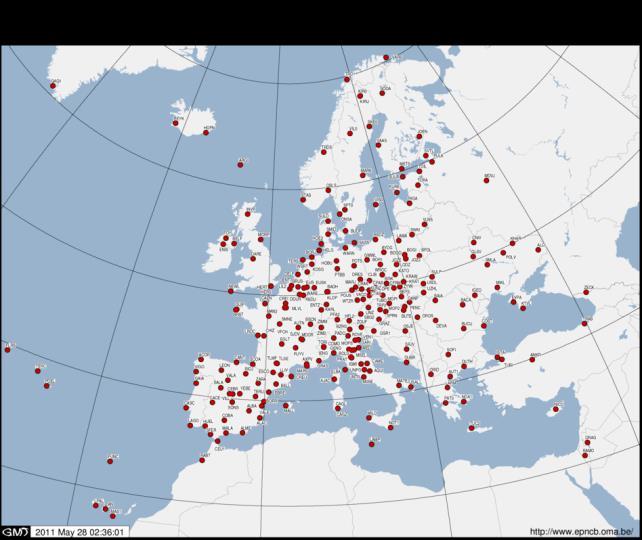
EUREF Permanent GNSS Network Carine Royal Observatory of Belgium
 ENEON first workshop Observing Europe: Networking the Earth Observation Networks in Europe EUREF Permanent GNSS Network Carine Bruyninx/C.Bruyninx@oma.be Royal Observatory of Belgium 1. About your network
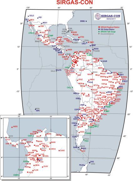
SIRGAS: the geodetic reference frame for Latin America and the Caribbean
 SIRGAS: the geodetic reference frame for Latin America and the Caribbean C. Brunini UNLP, Argentina L. Sánchez DGFI, Germany V. Mackern UNCuyo, UJAM, Argentina W. Martínez IGAC, Colombia R. Luz IBGE, Brazil
FieldGenius Technical Notes GPS Terminology
 FieldGenius Technical Notes GPS Terminology Almanac A set of Keplerian orbital parameters which allow the satellite positions to be predicted into the future. Ambiguity An integer value of the number of
GEONET -CORS Network of japan-
 GEONET -CORS Network of japan- Basara Miyahara Geospatial Information Authority of Japan Geospatial and GNSS CORS Infrastructure Forum Kuala Lumpur - Malaysia Geospatial Information Authority of Japan
MAGICGNSS RTCM-BASED SERVICE, A LEAP FORWARD TOWARDS MULTI- GNSS HIGH ACCURACY REAL-TIME PROCESSING
 ION GNSS 2015 MAGICGNSS RTCM-BASED SERVICE, A LEAP FORWARD TOWARDS MULTI- GNSS HIGH ACCURACY REAL-TIME PROCESSING SEPTEMBER 16 TH, 2015 - ION GNSS 2015, TAMPA, FLORIDA, USA SESSION E2A: NEXT GENERATION
Towards a EUREF Service Providing Real-time GNSS Clock and Orbit Corrections
 Towards a EUREF Service Providing Real-time GNSS Clock and Orbit Corrections G. Weber 1), W. Söhne 1), A. Stürze 1), L. Mervart 2) 1) Federal Agency for Cartography and Geodesy, Frankfurt am Main, Germany
ASSEMBLY 37TH SESSION
 International Civil Aviation Organization WORKING PAPER A37-WP/195 1 22/9/10 (Information paper) ASSEMBLY 37TH SESSION TECHNICAL COMMISSION Agenda Item 35: The Global Air Traffic Management (ATM) System
Supporting GNSS applications in Latin America through the SIRGAS reference frame
 United Nations/Argentina Workshop on the Applications of Global Navigation Satellite Systems Supporting GNSS applications in Latin America through the SIRGAS reference frame 1 Víctor Cioce, 2 William Martínez,
NTRIP Background History, Development & BKG. Networked Transport of RTCM via Internet Protocol
 Networked Transport of RTCM via Internet Protocol Networked Transport of RTCM via Internet Protocol Bundesamt für Kartographie und Geodäsie Motivation: Use Internet to transport GNSS corrections Communication
magicgnss: QUALITY DATA, ALGORITHMS AND PRODUCTS FOR THE GNSS USER COMMUNITY
 SEMANA GEOMATICA 2009 magicgnss: QUALITY DATA, ALGORITHMS AND PRODUCTS FOR THE GNSS USER COMMUNITY MARCH 3, 2009 BARCELONA, SPAIN SESSION: GNSS PRODUCTS A. Mozo P. Navarro R. Píriz D. Rodríguez March 3,
Multisystem Real Time Precise-Point-Positioning, today with GPS+GLONASS in the near future also with QZSS, Galileo, Compass, IRNSS
 2 International Symposium on /GNSS October 26-28, 2. Multisystem Real Time Precise-Point-Positioning, today with +GLONASS in the near future also with QZSS, Galileo, Compass, IRNSS Álvaro Mozo García,
Technical Specifications Document. for. Satellite-Based Augmentation System (SBAS) Testbed
 Testbed") Technical Specifications Document for Satellite-Based Augmentation System (SBAS) Testbed Revision 3 13 June 2017 Table of Contents Acronym Definitions... 3 1. Introduction... 4 2. SBAS Testbed Realisation...
Technical Specifications Document for Satellite-Based Augmentation System (SBAS) Testbed Revision 3 13 June 2017 Table of Contents Acronym Definitions... 3 1. Introduction... 4 2. SBAS Testbed Realisation...
Real-time challenges of an. Australian National Positioning Infrastructure
 Real-time challenges of an Australian National Positioning Infrastructure S. Melachroinos 1, T. Li 2,1, T. Papanikolaou 2,1, and J. Dawson 1 1 Geoscience Australia Geodesy Section GSM Group CSEM Division
WHU s developments for the MGEX precise products and the GNSS ultra-rapid products
 IGS Workshop 2016 WHU s developments for the MGEX precise products and the GNSS ultra-rapid products Chuang Shi; Qile Zhao; Min Li; Jing Guo; Jingnan Liu Presented by Jianghui Geng GNSS Research Center,
SSR & RTCM Current Status
 SSR & RTCM Current Status Gerhard Wübbena, Martin Schmitz, Jannes Wübbena Geo++ GmbH 30827 Garbsen, Germany www.geopp.de Outline RTCM SC104 WG s SSR Today SSR Formats SC104 RTCM-SSR Geo++ RTCM 4090 SSR
Who s heard of the GDA2020?
 Implications of a next generation datum in Australia on mining operations: A discussion. School of Civil & Environmental Engineering Craig Roberts Senior lecturer Surveying and Geospatial Engineering group
GNSS Low-Cost High-Accuracy Receiver (L-CHAR)
") GNSS Low-Cost High-Accuracy Receiver (L-CHAR) Dinesh Manandhar Center for Spatial Information Science The University of Tokyo Contact Information: dinesh@iis.u-tokyo.ac.jp Slide : 1 High Accuracy Receivers
GNSS Low-Cost High-Accuracy Receiver (L-CHAR) Dinesh Manandhar Center for Spatial Information Science The University of Tokyo Contact Information: dinesh@iis.u-tokyo.ac.jp Slide : 1 High Accuracy Receivers
Satellite-Based Augmentation System (SBAS) Integrity Services
 Integrity Services") Satellite-Based Augmentation System (SBAS) Integrity Services Presented To: Munich, Germany Date: March 8, 2010 By: Leo Eldredge, Manager GNSS Group, FAA FAA Satellite Navigation Program 2 Wide Area Augmentation
Satellite-Based Augmentation System (SBAS) Integrity Services Presented To: Munich, Germany Date: March 8, 2010 By: Leo Eldredge, Manager GNSS Group, FAA FAA Satellite Navigation Program 2 Wide Area Augmentation
MGA Webinar Series : 1 Very Cheap RTK Receivers: Changing the Landscape of Positioning Services
 MGA Webinar Series : 1 Very Cheap RTK Receivers: Changing the Landscape of Positioning Services Dinesh Manandhar Center for Spatial Information Science The University of Tokyo Contact Information: dinesh@iis.u-tokyo.ac.jp
Session 1.2 Regional and National Reference Systems. Asia Pacific. Dr John Dawson Leader - National Geodesy Program Geoscience Australia
 Session 1.2 Regional and National Reference Systems Asia Pacific Dr John Dawson Leader - National Geodesy Program Geoscience Australia Presentation Overview Part 1 Australia s contributions to the ITRF
Positioning Techniques. João F. Galera Monico - UNESP Tuesday 12 Sep
 Positioning Techniques João F. Galera Monico - UNESP Tuesday 12 Sep Positioning methods Absolute Positioning Static and kinematic SPP and PPP Relative Positioning Static Static rapid Semi kinematic Kinematic
European GNSS: Galileo and EGNOS for next generation Road Charging
 European GNSS: Galileo and EGNOS for next generation Road Charging 20 th October 2014 Gian Gherardo Calini European GNSS Agency (GSA) GNSS have made a huge impact in our society it is key in Road transportation
GPS and GNSS from the International Geosciences Perspective
 GPS and GNSS from the International Geosciences Perspective G. Beutler Astronomical Institute, University of Bern Member of IAG Executive Committee and of IGS Governing Board National Space-Based Positioning,
Status of the European EGNOS and Galileo Programmes. Frank Udnaes Galileo policy and Infrastructure group EC DG-TREN. June 2008
 Status of the European EGNOS and Galileo Programmes Frank Udnaes Galileo policy and Infrastructure group EC DG-TREN EUROPEAN COMMISSION z June 2008 Galileo An infrastructure 30 satellite Constellation
Update on the International Terrestrial Reference Frame (ITRF)
") Update on the International Terrestrial Reference Frame (ITRF) Zuheir Altamimi Head of the IERS ITRF Product Center Institut National de l Information Géographique et Forestière IGN, France E-mail: zuheir.altamimi@ign.fr
Update on the International Terrestrial Reference Frame (ITRF) Zuheir Altamimi Head of the IERS ITRF Product Center Institut National de l Information Géographique et Forestière IGN, France E-mail: zuheir.altamimi@ign.fr
Civil Applications of Galileo. Brussels, June 12, 2006 Ir. Peter A. Grognard Founder and CEO, Septentrio nv
 Civil Applications of Galileo Brussels, June 12, 2006 Ir. Peter A. Grognard Founder and CEO, Septentrio nv Company overview Founded January 21, 2000 in Leuven, Belgium Spin-off of Interuniversity MicroElectronics
Precise Positioning with NovAtel CORRECT Including Performance Analysis
 Precise Positioning with NovAtel CORRECT Including Performance Analysis NovAtel White Paper April 2015 Overview This article provides an overview of the challenges and techniques of precise GNSS positioning.
International Journal of Scientific & Engineering Research, Volume 6, Issue 8, August ISSN
 International Journal of Scientific & Engineering Research, Volume 6, Issue 8, August-2015 683 Assessment Accuracy of Static Relative Positioning Using Single Frequency GPS Receivers Mahmoud I. El-Mewafi
GNSS & Coordinate Systems
 GNSS & Coordinate Systems Matthew McAdam, Marcelo Santos University of New Brunswick, Department of Geodesy and Geomatics Engineering, Fredericton, NB May 29, 2012 Santos, 2004 msantos@unb.ca 1 GNSS GNSS
Experiences with Fugro's Real Time GPS/GLONASS Orbit/Clock Decimeter Level Precise Positioning System
 Return to Session Directory DYNAMIC POSITIONING CONFERENCE October 13-14, 2009 Sensors Experiences with Fugro's Real Time GPS/GLONASS Orbit/Clock Decimeter Level Precise Positioning System Ole Ørpen and
The last 25 years - GPS to multi-gnss: from a military tool to the most widely used civilian positioning solution
 1 The last 25 years - GPS to multi-gnss: from a military tool to the most widely used civilian positioning solution B. Hofmann-Wellenhof Institute of Geodesy / Navigation, Graz University of Technology
GPS STATIC-PPP POSITIONING ACCURACY VARIATION WITH OBSERVATION RECORDING INTERVAL FOR HYDROGRAPHIC APPLICATIONS (ASWAN, EGYPT)
") GPS STATIC-PPP POSITIONING ACCURACY VARIATION WITH OBSERVATION RECORDING INTERVAL FOR HYDROGRAPHIC APPLICATIONS (ASWAN, EGYPT) Ashraf Farah Associate Professor,College of Engineering, Aswan University,
GPS STATIC-PPP POSITIONING ACCURACY VARIATION WITH OBSERVATION RECORDING INTERVAL FOR HYDROGRAPHIC APPLICATIONS (ASWAN, EGYPT) Ashraf Farah Associate Professor,College of Engineering, Aswan University,
International Committee on Global Navigation Satellite Systems
 International Committee on Global Navigation Satellite Systems Training Course on Global Navigation Satellite Systems 14 18 January 2019, Asian Institute of Technology, Bangkok, Thailand Sharafat Gadimova
THE XXV FIG International Congress 2014
 THE XXV FIG International Congress 2014 1 ASIA OCEANIA MULTI-GNSS DEMONSTRATION CAMPAIGN Kazutoshi Sato, Hiroaki Tatashita, Wakabayashi Yaka, Hideshi Kakimoto, and Satoshi Kogure Multi-GNSS Asia Secretariat
Precise GNSS Positioning for Mass-market Applications
 Precise GNSS Positioning for Mass-market Applications Yang GAO, Canada Key words: GNSS, Precise GNSS Positioning, Precise Point Positioning (PPP), Correction Service, Low-Cost GNSS, Mass-Market Application
DYNAMIC RT TECHNOLOGY
 DYNAMIC RT TECHNOLOGY GLOBAL NAVIGATION SATELLITE SYSTEMS (GNSS) POTENTIAL FUTURE DEVELOPMENTS(2005 2017?) GPS MODERNIZATION BLOCK IIF & III GLONASS ENHANCEMENTS (K & M) EUROPEAN UNION - GALILEO CHINA
Radio Navigation Aids Flight Test Seminar
 Radio Navigation Aids Flight Test Seminar FLIGHT INSPECTION IN THE NEW MILLENNIUM Curt Keedy FAA Flight Inspection Policy and Standards Change, Challenge, and Opportunity CHANGES Global Positioning system
GNSS Accuracy Improvements through Multipath Mitigation with New Signals and services
 GNSS Accuracy Improvements through Multipath Mitigation with New Signals and services Andrey Veytsel, Ph.D Moscow Technical University 10 Meeting of the International Committee on Global Navigation Satellite
High Precision Applications with BeiDou
 High Precision Applications with BeiDou Lei HUANG Unicore Communications, Inc May 14, 2013 Contents 1 2 3 4 Background Overview of BeiDou high precision products Applications of BeiDou high precision products
MGEX Clock Determination at CODE
 source: http://boris.unibe.ch/74079/ downloaded: 13.3.2017 MGEX Clock Determination at CODE E. Orliac, L. Prange, R. Dach, S. Schaer and A. Jäggi Astronomical Institute of University of Bern (AIUB) Bern,
Geodetic policy for Ireland and Northern Ireland
 Geodetic policy for Ireland and Northern Ireland Background Ordnance Survey Ireland (OSi) is the National Mapping Agency (NMA) of the Republic of Ireland. The Ordnance Survey of Northern Ireland (OSNI)
NCS TITAN. The most powerful GNSS Simulator available. NCS TITAN Datasheet. Scalability. Extendability. In co-operation with
 NCS TITAN The most powerful GNSS Simulator available Scalability Fidelity Reliability Usability Extendability Flexibility Upgradability Features Signal Capabilities Support of all global (GNSS) and regional
Asian Journal of Science and Technology Vol. 08, Issue, 11, pp , November, 2017 RESEARCH ARTICLE
 Available Online at http://www.journalajst.com ASIAN JOURNAL OF SCIENCE AND TECHNOLOGY ISSN: 0976-3376 Asian Journal of Science and Technology Vol. 08, Issue, 11, pp.6697-6703, November, 2017 ARTICLE INFO
The topic we are going to see in this unit, the global positioning system, is not directly related with the computer networks we use everyday, but it
 The topic we are going to see in this unit, the global positioning system, is not directly related with the computer networks we use everyday, but it is indeed a kind of computer network, as the specialised
GNSS Training for ITS Developers. 1 - GNSS Principles
 GNSS Training for ITS Developers 1 - GNSS Principles Table of Content Introduction to Satellite Navigation Systems Basics on GNSS Receivers Galileo, the European GNSS EGNOS, the European Augmentation System
European GNSS Evolution
 Ref. Ares(204)902599 - /06/204 European GNSS Evolution Hermann Ebner Galileo and EGNOS Programme Management DG Enterprise and Industry Content Introduction 2 2 Major Challenges for EGNSS Evolution 3 EGNSS
GNSS 101 Bringing It Down To Earth
 GNSS 101 Bringing It Down To Earth Steve Richter Frontier Precision, Inc. UTM County Coordinates NGVD 29 State Plane Datums Scale Factors Projections Session Agenda GNSS History & Basic Theory Coordinate
GPS/WAAS Program Update
 GPS/WAAS Program Update UN/Argentina Workshop on the Applications of GNSS 19-23 March 2018 Cordoba, Argentina GNSS: A Global Navigation Satellite System of Systems Global Constellations GPS (24+3) GLONASS
Real-time Stream Conversion to RTCM-3 MSM and RINEX-3 in IGS/MGEX Context
 Real-time Stream Conversion to RTCM-3 MSM and RINEX-3 in IGS/MGEX Context Georg Weber (BKG), Ken MacLeod (NRCan), Leos Mervart (CTU), Oliver Montenbruck (DLR), James Perlt (BKG), Dirk Stöcker (Alberding),
INTEROPERABILITY OF THE GNSS'S FOR POSITIONING AND TIMING. A. Caporali, L. Nicolini University of Padova, Italy
 INTEROPERABILITY OF THE GNSS'S FOR POSITIONING AND TIMING A. Caporali, L. Nicolini University of Padova, Italy Outlook Monitor 31 European GNSS sites with 5 different receivers (Javad, Leica, Septentrio,
Precise Positioning with Smartphones running Android 7 or later
 Precise Positioning with Smartphones running Android 7 or later * René Warnant, * Cécile Deprez, + Quentin Warnant * University of Liege Geodesy and GNSS + Augmenteo, Plaine Image, Lille (France) Belgian
Satellite Laser Retroreflectors for GNSS Satellites: ILRS Standard
 Satellite Laser Retroreflectors for GNSS Satellites: ILRS Standard Michael Pearlman Director Central Bureau International Laser Ranging Service Harvard-Smithsonian Center for Astrophysics Cambridge MA
VARIATION OF STATIC-PPP POSITIONING ACCURACY USING GPS-SINGLE FREQUENCY OBSERVATIONS (ASWAN, EGYPT)
") ARTIFICIAL SATELLITES, Vol. 52, No. 2 2017 DOI: 10.1515/arsa-2017-0003 VARIATION OF STATIC-PPP POSITIONING ACCURACY USING GPS-SINGLE FREQUENCY OBSERVATIONS (ASWAN, EGYPT) Ashraf Farah Associate professor,
ARTIFICIAL SATELLITES, Vol. 52, No. 2 2017 DOI: 10.1515/arsa-2017-0003 VARIATION OF STATIC-PPP POSITIONING ACCURACY USING GPS-SINGLE FREQUENCY OBSERVATIONS (ASWAN, EGYPT) Ashraf Farah Associate professor,
Galileo Aktueller Stand der Entwicklung
 Galileo Aktueller Stand der Entwicklung Is there a positive perspective for Galileo? Dr. Philipp Berglez TeleConsult Austria GmbH GSV-Forum Galileo das europäische Satellitennavigationssystem eine neue
Performance Evaluation of Differential Global Navigation Satellite System with RTK Corrections
 IOSR Journal of Electronics and Communication Engineering (IOSR-JECE) e-issn: 2278-2834,p- ISSN: 2278-8735.Volume 9, Issue 2, Ver. VI (Mar - Apr. 2014), PP 43-47 Performance Evaluation of Differential
Lecture-1 CHAPTER 2 INTRODUCTION TO GPS
 Lecture-1 CHAPTER 2 INTRODUCTION TO GPS 2.1 History of GPS GPS is a global navigation satellite system (GNSS). It is the commonly used acronym of NAVSTAR (NAVigation System with Time And Ranging) GPS (Global
GAVIN DOCHERTY & CRAIG ROBERTS School of Surveying & Spatial Information Systems. University of NSW
 FIG2010, Sydney, Australia 15 April 2010 The impact of Solar Cycle 24 on Network RTK in Australia GAVIN DOCHERTY & CRAIG ROBERTS School of Surveying & Spatial Information Systems University of NSW School
GBAS FOR ATCO. June 2017
 GBAS FOR ATCO June 2017 Disclaimer This presentation is for information purposes only. It should not be relied on as the sole source of information, and should always be used in the context of other authoritative
Analysis of GNSS Receiver Biases and Noise using Zero Baseline Techniques
 1 Analysis of GNSS Receiver Biases and Noise using Zero Baseline Techniques Ken MacLeod, Simon Banville, Reza Ghoddousi-Fard and Paul Collins Canadian Geodetic Survey, Natural Resources Canada Plenary