ENGRG Introduction to GIS
|
|
|
- Geoffrey Bishop
- 5 years ago
- Views:
Transcription

1 ENGRG Introduction to GIS Michael Piasecki December 01, 2017 Lecture 12: GPS Systems


2 Lecture 7: Introduction To GPS November 27, 2017 ENGRG Intro to GIS 2


3 November 27, 2017 ENGRG Intro to GIS 3
4 Introduction to GPS 1. Basic of GPS GPS history and application Segments of GPS GPS Signals 2. How does GPS work? 3. GPS Errors GPS Error Sources Measurements of GPS error Error Correction November 27, 2017 ENGRG Intro to GIS 4
5 Global Positioning System (GPS) Satellite navigational system that provides accurate coordinates worldwide. Satellites and computers to locate positions Controlled by the Department of Defense, US Air Force Usable by anyone, anytime, for free systems: U.S. NAVSTAR (Navigation Satellite Timing And Ranging), the official DoD name for GPS Russia GLONASS (Global Navigation Satellite System) EU Galileo Global Navigation Satellite System (build by EU and ESA) Chinese Compass System November 27, 2017 ENGRG Intro to GIS 5

6 History: The UAVSTAR GPS : Proof of concept 1976: US Congress approved development 1978: First satellites launched Assets belongs to US Government Stewardship via US Dept of Defense First real operational test for GPS technology was the Gulf War in 1990 June 26, 1993, the 24th satellite into orbit Full constellation achieved in 1995 Selective Availability turned off by President Clinton in May 1 st, 2000 But also authorization of GPS III modernization, starting 2017 Currently 31 satellites in orbit of various ages and type Ultimately 62 are planned for November 27, 2017 ENGRG Intro to GIS 6
7 Non US Positioning Systems GLONASS Global Navigation Satellite System Russian Federation Ministry of Defense Has deteriorated over time; not complete Being restored to full availability in partership with India GALILEO EU + 6 non EU countries: China, India, Israel, Morocco, Saudi Arabia and Ukraine First 4 satellites in orbit by 09/12/2012 from Kazakhstan 30 satellite (27 + 3) Full operation expected in 2019 Pentagon: unnecessary; potential security threat during wartime November 27, 2017 ENGRG Intro to GIS 7
8 Non US Positioning systems Baidou: China s regional system that China proposed to expand into a global system named COMPASS. QZSS: Japanese proposed regional system, adding better coverage to the Japanese islands; Indian regional Satellite System (IRNSS): India s proposed regional system. November 27, 2017 ENGRG Intro to GIS 8
 Users Segment: users with receivers November 27, 2017 ENGRG 59910 Intro to GIS")
9 GPS Three Segments Space Segment:the constellation of satellites Control Segment: Monitors system performance and adjusts satellites (USAF) Users Segment: users with receivers November 27, 2017 ENGRG Intro to GIS 9

10 GPS Three Segments November 27, 2017 ENGRG Intro to GIS 10


11 Space Segment November 27, 2017 ENGRG Intro to GIS 11
12 Space Segment System consists of 24 satellites in the operational mode; As of 2014, 32 actively satellites; Altitude: 20,200 Km with periods of 12 hr. Current Satellites: Block IIF $25,000,000; 2000 KG Solar powered, backup batteries, rocket boosters Hydrogen Maser Atomic Clocks November 27, 2017 ENGRG Intro to GIS 12

13 Hydrogen Master Clock These clocks lose one second every 2,739,000 million years The GPS satellites are nothing more than a set of clocks in the sky November 27, 2017 ENGRG Intro to GIS 13

14 GPS Orbits November 27, 2017 ENGRG Intro to GIS 14


15 Control Segment Schriever November 27, 2017 ENGRG Intro to GIS 15
 November 27, 2017 ENGRG 59910 Intro to GIS 16")
16 Consolidated Space Operations Center: CSOC Master Control Station is located at the Consolidated Space Operations Center (CSOC) at Schriever Air Force Station near Colorado Springs Track the satellites for orbit and clock determination Time synchronization Upload the Navigation Message Manage DOA (dead on arrival) November 27, 2017 ENGRG Intro to GIS 16


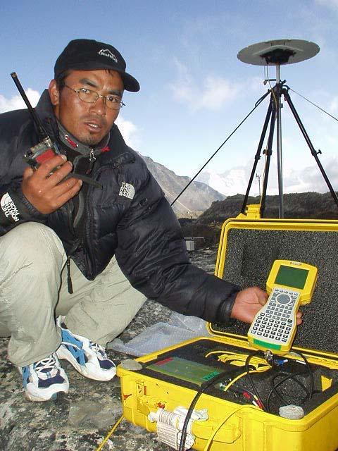
17 User Segment: Military and Civilian GPS on the Battlefield Conflicting Interests Military needs a secure system Civilians need unrestricted access In Rainforest, Brazil November 27, 2017 ENGRG Intro to GIS 17
18 Satellite Signals (2+3) 2 Microwave Carrier Codes Atomic clocks on satellites generate a pure sine wave Fundamental frequency, f o MHz L1 and L2 carrier waves f 1 = f o x 154 = MHz (19 cm) f 2 = f o x 120 = MHz (24 cm) Other Carrier Codes L3 ( MHZ) used by Nuclear Detonation Detection System L4 ( Mhz) Being studied for additional ionospheric correction. L5 ( Mhz): proposed for civilian safety of life (SoL) signal. November 27, 2017 ENGRG Intro to GIS 18
19 Satellite Signals (2+3) 3 Pseudorandom codes (Binary code) Navigation message must be modified, or modulated, to contain information C/A Code Coarse/Acquisition Code available for civilian use on L1 (3 to 300 meters) P Code Precise/Private Code on L1 and L2 used by the military (30 centimeters to 30 meters) November 27, 2017 ENGRG Intro to GIS 19
20 Satellite Signals Navigation Message Modulates on L1 and L2 50 Hz Entire message is 1500 bits; 30 sec Includes information such as: Predicted satellite ephemeris data. Predicted satellite clock correction model coefficients. GPS system status information The GPS system ionospheric model Almanac: used to identify where satellites will be and when (the bus schedule ) November 27, 2017 ENGRG Intro to GIS 20
21 Satellite Signals C/A (Course/Acquisition) Code Modulates on L1 carrier MHz Pseudo Random Noise (PRN) code Entire message 1023 bits transmitted at Mbit/s => hence it repeats every millisecond Wavelength of 300 m Hence total sequence is about 300km long Unique C/A from each satellite Highly orthogonal to each other => code division multiple access (CDMA) recognition of multiple satellites on same frequency November 27, 2017 ENGRG Intro to GIS 21
22 Satellite Signals P (Precise or Private) Code Much more complicated Modulates on L1 and L MHz PRN (pseudo random noise) code Wavelength of 30 m Anti Spoofing mode includes an encrypted W code to create the Y code Classified decryption November 27, 2017 ENGRG Intro to GIS 22

23 GPS Signals November 27, 2017 ENGRG Intro to GIS 23

24 GPS Signals: Navigation Message and also its health status orbital information November 27, 2017 ENGRG Intro to GIS 24
25 GPS: Satellite Ranging Simple: Distance = Speed * Time Measuring distance from satellite(s) by Knowing the location of the satellite(s), and Measuring travel time of radio signals between the target and the satellites). Pseudo range: range with error November 27, 2017 ENGRG Intro to GIS 25
26 GPS: How does it work? The GPS receiver and a satellite produce the same signal at a given time. Good clocks important Receiver measures the delay between generating a time signal and receiving the same time from the satellite. Simple! t Time Difference 1 t 0 Range distance = c * (t 1 -t 0 ) November 27, 2017 ENGRG Intro to GIS 26
27 GPS Receivers Standard Positioning Service Usually configured with quartz clocks (less accurate than atomic) Single frequency (L1) C/A code ranging Civilian uses, typical receivers Precise Positioning Service Dual frequency (L1 and L2) P code P code contains higher resolution info Two frequency channels enables atmospheric corrections Commonly used for national interests Signals from 4 Satellites are required November 27, 2017 ENGRG Intro to GIS 27


28 4 Satellites are required November 27, 2017 ENGRG Intro to GIS 28
29 Clock Offset The three spheres will not intersect 5 sec (wrong) 7 sec (wrong) 9 sec (wrong) November 27, 2017 ENGRG Intro to GIS 29
30 Why Four Satellites? Satellites carry highly accurate atomic (Cesium and Rubidium) clocks onboard. GPS receivers have much less accurate quartz clocks. With positional fixes from 3 satellites, a timing error of only 1/1,000,000 of a second between the satellite and the receiver equals a positional error of 300 meters or more on the ground! November 27, 2017 ENGRG Intro to GIS 30
31 GPS: How does it work? More Satellites equals Better Resolution November 27, 2017 ENGRG Intro to GIS 31
32 GPS Accuracy GPS measurements are not totally accurate Depending on your GPS receiver, you can achieve different levels of accuracy. More satellites used, more sophisticated processing = greater accuracy More accurate receivers are more expensive GPS Receiver Accuracy Price Range Recreational 5-30 m $100-$3000 Mapping 1-5 m $10000-$50000 Geodetic < 50 cm >$50000 November 27, 2017 ENGRG Intro to GIS 32


33 Basic Positioning: Today 6-10 m C/A Code on L1 Before May 2000: m November 27, 2017 ENGRG Intro to GIS 33
 US operates one via Coast Guard; ground based system correct satellite estimates.")
34 Basic Positioning: Tomorrow Better resistance to interference C/A Code on L1 L2C Code on L2 New Code on L5 1-5 m Eliminates need for costly DGPS in many non safety applications Differential Global Positioning System (up to 10cm accuracy) US operates one via Coast Guard; ground based system correct satellite estimates. November 27, 2017 ENGRG Intro to GIS 34
35 Systematic Sources of GPS Error Satellite clock error, ephemeris error Atmospheric Refraction Ionospheric Refraction Tropospheric Refraction Multipath Signal Obstruction Selective Availability Receiver clock error Human Error observatory.org/gps/gps_accuracy.html November 27, 2017 ENGRG Intro to GIS 35
36 GPS Errors Sources of User Equivalent Range Errors (UERE) Ionospheric effects ± 5 meter Ephemeris errors ± 2.5 meter Satellite clock errors ± 2 meter Multipath distortion ± 1 meter Tropospheric effects ± 0.5 meter Numerical errors ± 1 meter November 27, 2017 ENGRG Intro to GIS 36
37 Atmospheric Effects Signal speed varies: Refraction Signal bounced by ionosphere: Reflection Time of signal propagation affected: Error November 27, 2017 ENGRG Intro to GIS 37
38 Multi Path Error Occurs when GPS signals are reflected and the receiver detects two signal instead of one at different times. This causes confusion in some low end GPS units, but is generally easy to correct. High end receivers compensate for multipath Mapping and Survey units use a hardware solution: a special semidirectional antenna November 27, 2017 ENGRG Intro to GIS 38
39 Multipath November 27, 2017 ENGRG Intro to GIS 39
40 Signal Obstruction When something blocks the GPS signal Areas of Great Elevation Differences Canyons Mountain Obstruction Urban Environments Indoors November 27, 2017 ENGRG Intro to GIS 40
41 Obstruction November 27, 2017 ENGRG Intro to GIS 41

42 Using Off Set Positioning Used to compensate for obstruction Uses compass bearing and an offset distance to calculate the position of the obstructed target. Trimble Pathfinder Pro XR unit has this capability November 27, 2017 ENGRG Intro to GIS 42
43 Selective Availability (S/A) Government introduces artificial errors to reduce GPS position accuracy Discourages hostile forces from using GPS Largest source of error How does it work? Off setting satellite clocks. Introduction of ephemeris error by the Space Command control center Only the military has the correction information. November 27, 2017 ENGRG Intro to GIS 43
44 S/A Error Will it be turned on in case of War? 100 meters 100 meters 40 meters 20 meters November 27, 2017 ENGRG Intro to GIS 44
45 S/A Status In 1996 it was announced that S/A would be phased out and turned off within 4 years On May 1st 2000, S/A was turned off, but the military can still turn it on when necessary In 2006 S/A was turned off permanently In 2007 US gov announced the production of future generation GPS satellites, GPS III, without the S/A to be ever switched on again November 27, 2017 ENGRG Intro to GIS 45

46 Measuring GPS Error: DOP DOP = Dilution of Precision DOP is a measurement of error DOP Values usually range from 1 to 6 Low values are best November 27, 2017 ENGRG Intro to GIS 46
47 Dilution of Precision (DOP) It is best to have satellites spaced evenly around the receiver with one satellite overhead and one low on the horizon. High DOP values are found when satellites are clustered together. November 27, 2017 ENGRG Intro to GIS 47
48 Measurements of DOP PDOP (Position Dilution of Precision): the most commonly used, measures DOP in 3D. HDOP (Horizontal Dilution of Precision): measures DOP in 2D (horizontal only). VDOP (Vertical Dilution of Precision): measures DOP in the vertical only. TDOP (Time Dilution of Precision): measures DOP with respect to time. November 27, 2017 ENGRG Intro to GIS 48
49 Error Correction Differential correction Uses a base station Post processing Real time Wide Area Augmentation System, WAAS Uses reference stations to calculate corrections (<3m accurate) Even better than DGPS November 27, 2017 ENGRG Intro to GIS 49

50 Differential GPS (DGPS) Obtain GPS position at a site with known position (base station) Derive difference between actual and GPS positions Post processing vs. Real Time processing November 27, 2017 ENGRG Intro to GIS 50
51 DGPS November 27, 2017 ENGRG Intro to GIS 51
52 Differential GPS DGPS Apply appropriate correction to nearby rover positions Real time beacon receiver (USCG) with rover Real time with radio receiver with rover Post processing: With correction files, let the computer apply correction in the office Base station can be Yours (2nd GPS in field, dedicated station in office ) Government (USCG, etc.) Commercial November 27, 2017 ENGRG Intro to GIS 52

53 DGPS: USCG Radio Beacon The Coast Guard s maritime DGPS service provides 10 meter (2 drms) navigation accuracy, integrity alarms for GPS and DGPS out-oftolerance conditions within 10 seconds of detection, availability of 99.7% per month. Typically, the positional error of a DGPS position is 1 to 3 meters. November 27, 2017 ENGRG Intro to GIS 53
54 Wide Area Augmentation System, WAAS Developed by Federal Aviation Administration (FAA) for aircraft navigation Available to everyone in North America 25 ground stations across US monitor GPS errors (2 master stations in coast) Corrections sent to geosynchronous satellites, or satellite with a fixed position over the equator WAAS equipped GPS receiver uses corrections from satellites to improve accuracy 95% accuracy typically on order of 3 meters Not expensive (do not require additional receiver) November 27, 2017 ENGRG Intro to GIS 54

55 Wide Area Augmentation System Confirmed accuracy performance of 1 2 meters horizontal and 2 3 meters vertical throughout the majority of the continental U.S. and portions of Alaska. November 27, 2017 ENGRG Intro to GIS 55
56 Wide Area Augmentation System November 27, 2017 ENGRG Intro to GIS 56
57 Project Presentation Recall: Date: December 8 th Ignite Format; that is 21 slides at 20secs each = 7minutes Presentations on Friday 12 th : Lec 10 * (7 + 3 for change and Q&A) = 100mins (1hr 40mins) Lab 5 * (7 + 3 for change and Q&A) = 50mins That means if we start at 10:00 sharp we should be out by 12:30am => presenters be there by 9:40 so we can load PPTs Lastly: presentation order => November 27, 2017 ENGRG Intro to GIS 57
58 Project Presentation Order Random lottery! Friday 12/08 Lec Friday 12/08 Lab Sossa Awolou 1 Abu Ghazaleh Camelia Taveras Fausto 2 Oei Angela Loo Erica 3 Yu Wendy Bhuiyan Nazmul 4 Cham David Frias Jay 5 Pena Adrian Rappa Valentina 6 Hincapie Cesar Fey Jeremy 7 Ramsay Vivian Singh Harjinder 8 BREAK November 27, 2017 ENGRG Intro to GIS 58
Resection. We can measure direction in the real world! Lecture 10: Position Determination. Resection Example: Isola, Slovenia. Professor Keith Clarke
 Geography 12: Maps and Spatial Reasoning Lecture 10: Position Determination We can measure direction in the real world! Professor Keith Clarke Resection Resection Example: Isola, Slovenia Back azimuth
UNIT 1 - introduction to GPS
 UNIT 1 - introduction to GPS 1. GPS SIGNAL Each GPS satellite transmit two signal for positioning purposes: L1 signal (carrier frequency of 1,575.42 MHz). Modulated onto the L1 carrier are two pseudorandom
GLOBAL POSITIONING SYSTEMS. Knowing where and when
 GLOBAL POSITIONING SYSTEMS Knowing where and when Overview Continuous position fixes Worldwide coverage Latitude/Longitude/Height Centimeter accuracy Accurate time Feasibility studies begun in 1960 s.
NR402 GIS Applications in Natural Resources
 NR402 GIS Applications in Natural Resources Lesson 5 GPS/GIS integration Global Positioning System (GPS)..a global navigation system that everyone can use What is GPS? How does it work? How accurate is
The Global Positioning System
 The Global Positioning System 5-1 US GPS Facts of Note DoD navigation system First launch on 22 Feb 1978, fully operational in 1994 ~$15 billion (?) invested to date 24 (+/-) Earth-orbiting satellites
GPS Milestones, cont. GPS Milestones. The Global Positioning Sytem, Part 1 10/10/2017. M. Helper, GEO 327G/386G, UT Austin 1. US GPS Facts of Note
 The Global Positioning System US GPS Facts of Note DoD navigation system First launch on 22 Feb 1978, fully operational in 1994 ~$15 billion (?) invested to date 24 (+/-) Earth-orbiting satellites (SVs)
What is a GPS How does GPS work? GPS Segments GPS P osition Position Position Accuracy Accuracy Accuracy GPS A pplications Applications Applications
 What is GPS? What is a GPS How does GPS work? GPS Segments GPS Position Accuracy GPS Applications What is GPS? The Global Positioning System (GPS) is a precise worldwide radio-navigation system, and consists
FieldGenius Technical Notes GPS Terminology
 FieldGenius Technical Notes GPS Terminology Almanac A set of Keplerian orbital parameters which allow the satellite positions to be predicted into the future. Ambiguity An integer value of the number of
GLOBAL NAVIGATION SATELLITE SYSTEMS (GNSS) ECE 2526E Tuesday, 24 April 2018
 ECE 2526E Tuesday, 24 April 2018") GLOBAL NAVIGATION SATELLITE SYSTEMS (GNSS) ECE 2526E Tuesday, 24 April 2018 MAJOR GLOBAL NAVIGATION SATELLITE SYSTEMS (GNSS) Global Navigation Satellite System (GNSS) includes: 1. Global Position System
GLOBAL NAVIGATION SATELLITE SYSTEMS (GNSS) ECE 2526E Tuesday, 24 April 2018 MAJOR GLOBAL NAVIGATION SATELLITE SYSTEMS (GNSS) Global Navigation Satellite System (GNSS) includes: 1. Global Position System
GPS Global Positioning System
 GPS Global Positioning System 10.04.2012 1 Agenda What is GPS? Basic consept History GPS receivers How they work Comunication Message format Satellite frequencies Sources of GPS signal errors 10.04.2012
GPS and Recent Alternatives for Localisation. Dr. Thierry Peynot Australian Centre for Field Robotics The University of Sydney
 GPS and Recent Alternatives for Localisation Dr. Thierry Peynot Australian Centre for Field Robotics The University of Sydney Global Positioning System (GPS) All-weather and continuous signal system designed
Introduction to the Global Positioning System
 GPS for Fire Management - 2004 Introduction to the Global Positioning System Pre-Work Pre-Work Objectives Describe at least three sources of GPS signal error, and identify ways to mitigate or reduce those
The GLOBAL POSITIONING SYSTEM James R. Clynch February 2006
 The GLOBAL POSITIONING SYSTEM James R. Clynch February 2006 I. Introduction What is GPS The Global Positioning System, or GPS, is a satellite based navigation system developed by the United States Defense
What is it? History. Other systems. How does it work? Trilateration GEOG 201 4/28/2010. Instructor: Pesses 1. {06} The Global Positioning System
 What is it? {06} The Global Positioning System G.P.S. = Global Positioning System Different from G.I.S. (Geographic Information Systems) Map Interpretation & GPS Spring 2010 M. Pesses History Conceived
PRINCIPLES AND FUNCTIONING OF GPS/ DGPS /ETS ER A. K. ATABUDHI, ORSAC
 PRINCIPLES AND FUNCTIONING OF GPS/ DGPS /ETS ER A. K. ATABUDHI, ORSAC GPS GPS, which stands for Global Positioning System, is the only system today able to show you your exact position on the Earth anytime,
GPS: The Basics. Darrell R. Dean, Jr. Civil and Environmental Engineering West Virginia University. Expected Learning Outcomes for GPS
 GPS: The Basics Darrell R. Dean, Jr. Civil and Environmental Engineering West Virginia University Expected Learning Outcomes for GPS Explain the acronym GPS Name 3 important tdt dates in history of GPS
King AbdulAziz University. Faculty of Environmental Design. Geomatics Department. Mobile GIS GEOM 427. Lecture 3
 King AbdulAziz University Faculty of Environmental Design Geomatics Department Mobile GIS GEOM 427 Lecture 3 Ahmed Baik, Ph.D. Email: abaik@kau.edu.sa Eng. Fisal Basheeh Email: fbasaheeh@kau.edu.sa GNSS
Introduction to Geographic Information Science. Last Lecture. Today s Outline. Geography 4103 / GNSS/GPS Technology
 Geography 4103 / 5103 Introduction to Geographic Information Science GNSS/GPS Technology Last Lecture Geoids Ellipsoid Datum Projection Basics Today s Outline GNSS technology How satellite based navigation
Introduction to NAVSTAR GPS
 Introduction to NAVSTAR GPS Charlie Leonard, 1999 (revised 2001, 2002) The History of GPS Feasibility studies begun in 1960 s. Pentagon appropriates funding in 1973. First satellite launched in 1978. System
GPS Errors. Figure 1. Four satellites are required to determine a GPS position.
 Expl ai ni nggps:thegl obalposi t i oni ngsyst em since a minimum of four satellites is required to calculate a position (Fig 1). However, many newer GPS receivers are equipped to receive up to 12 satellite
Introduction to the Global Positioning System
 GPS for ICS - 2003 Introduction to the Global Positioning System Pre-Work Pre-Work Objectives Describe at least three sources of GPS signal error, and ways to mitigate or reduce those errors. Identify
Errors in GPS. Errors in GPS. Geodetic Co-ordinate system. R. Khosla Fall Semester
 Errors in GPS Errors in GPS GPS is currently the most accurate positioning system available globally. Although we are talking about extreme precision and measuring distances by speed of light, yet there
Introduction. Global Positioning System. GPS - Intro. Space Segment. GPS - Intro. Space Segment - Contd..
 Introduction Global Positioning System Prof. D. Nagesh Kumar Dept. of Civil Engg., IISc, Bangalore 560 012, India URL: http://www.civil.iisc.ernet.in/~nagesh GPS is funded and controlled by U. S. Department
Proceedings of Al-Azhar Engineering 7 th International Conference Cairo, April 7-10, 2003.
 Proceedings of Al-Azhar Engineering 7 th International Conference Cairo, April 7-10, 2003. MODERNIZATION PLAN OF GPS IN 21 st CENTURY AND ITS IMPACTS ON SURVEYING APPLICATIONS G. M. Dawod Survey Research
GLOBAL POSITIONING SYSTEMS
 GLOBAL POSITIONING SYSTEMS GPS & GIS Fall 2017 Global Positioning Systems GPS is a general term for the navigation system consisting of 24-32 satellites orbiting the Earth, broadcasting data that allows
Basics of Satellite Navigation an Elementary Introduction Prof. Dr. Bernhard Hofmann-Wellenhof Graz, University of Technology, Austria
 Basics of Satellite Navigation an Elementary Introduction Prof. Dr. Bernhard Hofmann-Wellenhof Graz, University of Technology, Austria CONCEPT OF GPS Prof. Dr. Bernhard Hofmann-Wellenhof Graz, University
Global Positioning Systems (GPS) Trails: the achilles heel of mapping from the air / satellites
 Trails: the achilles heel of mapping from the air / satellites") Global Positioning Systems (GPS) Trails: the achilles heel of mapping from the air / satellites Google maps updated regularly by local users using GPS Also: http://openstreetmaps.org GPS applications
Global Positioning Systems (GPS) Trails: the achilles heel of mapping from the air / satellites Google maps updated regularly by local users using GPS Also: http://openstreetmaps.org GPS applications
Lecture-1 CHAPTER 2 INTRODUCTION TO GPS
 Lecture-1 CHAPTER 2 INTRODUCTION TO GPS 2.1 History of GPS GPS is a global navigation satellite system (GNSS). It is the commonly used acronym of NAVSTAR (NAVigation System with Time And Ranging) GPS (Global
What is GPS? GPS Position Accuracy. GPS Applications. What is a GPS. How does GPS work? GPS Segments
 What is GPS? What is a GPS How does GPS work? GPS Segments GPS Position Accuracy GPS Applications 1 What is GPS? The Global Positioning System (GPS) is a precise worldwide radio-navigation system, and
Sources of Geographic Information
 Sources of Geographic Information Data properties: Spatial data, i.e. data that are associated with geographic locations Data format: digital (analog data for traditional paper maps) Data Inputs: sampled
Fundamentals of GPS Navigation
 Fundamentals of GPS Navigation Kiril Alexiev 1 /76 2 /76 At the traditional January media briefing in Paris (January 18, 2017), European Space Agency (ESA) General Director Jan Woerner explained the knowns
Global Positioning Systems - GPS
 Global Positioning Systems - GPS GPS Why? What is it? How does it work? Differential GPS How can it help me? GPS Why?? Where am I? How do I get there? Where are you, and how do I get to You? WHO CARES???
Principal Investigator Co-Principal Investigator Co-Principal Investigator Prof. Talat Ahmad Vice-Chancellor Jamia Millia Islamia Delhi
 Subject Paper No and Title Module No and Title Module Tag Geology Remote Sensing and GIS Concepts of Global Navigation Satellite RS & GIS XXXIII Principal Investigator Co-Principal Investigator Co-Principal
Global Positioning System: what it is and how we use it for measuring the earth s movement. May 5, 2009
 Global Positioning System: what it is and how we use it for measuring the earth s movement. May 5, 2009 References Lectures from K. Larson s Introduction to GNSS http://www.colorado.edu/engineering/asen/
Global Positioning Systems -GPS
 Global Positioning Systems -GPS GPS Why? What is it? How does it work? Differential GPS How can it help me? GPS Why?? Where am I? How do I get there? Where are you, and how do I get to You? WHO CARES???
Challenges and Solutions for GPS Receiver Test
 Challenges and Solutions for GPS Receiver Test Presenter: Mirin Lew January 28, 2010 Agenda GPS technology concepts GPS and GNSS overview Assisted GPS (A-GPS) Basic tests required for GPS receiver verification
ORBITAL NAVIGATION SYSTEMS PRESENT AND FUTURE TENDS
 ORBITAL NAVIGATION SYSTEMS PRESENT AND FUTURE TENDS CONTENT WHAT IS COVERED A BRIEF HISTORY OF SYSTEMS PRESENT SYSTEMS IN USE PROBLEMS WITH SATELLITE SYSTEMS PLANNED IMPROVEMENTS CONCLUSION CONTENT WHAT
ESTIMATION OF IONOSPHERIC DELAY FOR SINGLE AND DUAL FREQUENCY GPS RECEIVERS: A COMPARISON
 ESTMATON OF ONOSPHERC DELAY FOR SNGLE AND DUAL FREQUENCY GPS RECEVERS: A COMPARSON K. Durga Rao, Dr. V B S Srilatha ndira Dutt Dept. of ECE, GTAM UNVERSTY Abstract: Global Positioning System is the emerging
Problem Areas of DGPS
 DYNAMIC POSITIONING CONFERENCE October 13 14, 1998 SENSORS Problem Areas of DGPS R. H. Prothero & G. McKenzie Racal NCS Inc. (Houston) Table of Contents 1.0 ABSTRACT... 2 2.0 A TYPICAL DGPS CONFIGURATION...
DEFINING THE FUTURE OF SATELLITE SURVEYING WITH TRIMBLE R-TRACK TECHNOLOGY
 DEFINING THE FUTURE OF SATELLITE SURVEYING WITH TRIMBLE R-TRACK TECHNOLOGY EDMOND NORSE, GNSS PORTFOLIO MANAGER, TRIMBLE SURVEY DIVISION WESTMINSTER, CO USA ABSTRACT In September 2003 Trimble introduced
TEST YOUR SATELLITE NAVIGATION PERFORMANCE ON YOUR ANDROID DEVICE GLOSSARY
 TEST YOUR SATELLITE NAVIGATION PERFORMANCE ON YOUR ANDROID DEVICE GLOSSARY THE GLOSSARY This glossary aims to clarify and explain the acronyms used in GNSS and satellite navigation performance testing
GPS Glossary Written by Carl Carter SiRF Technology 2005
 GPS Glossary Written by Carl Carter SiRF Technology 2005 This glossary provides supplementary information for students of GPS Fundamentals. While many of the terms can have other definitions from those
GNSS 101 Bringing It Down To Earth
 GNSS 101 Bringing It Down To Earth Steve Richter Frontier Precision, Inc. UTM County Coordinates NGVD 29 State Plane Datums Scale Factors Projections Session Agenda GNSS History & Basic Theory Coordinate
GNSS Signal Structures
 GNSS Signal Structures Tom Stansell Stansell Consulting Tom@Stansell.com Bangkok, Thailand 23 January 2018 S t a n s e l l C o n s u l t i n g RL Introduction It s a pleasure to speak with you this morning.
Primer on GPS Operations
 MP Rugged Wireless Modem Primer on GPS Operations 2130313 Rev 1.0 Cover illustration by Emma Jantz-Lee (age 11). An Introduction to GPS This primer is intended to provide the foundation for understanding
Global Navigation Satellite Systems II
 Global Navigation Satellite Systems II AERO4701 Space Engineering 3 Week 4 Last Week Examined the problem of satellite coverage and constellation design Looked at the GPS satellite constellation Overview
CHAPTER 22 SATELLITE NAVIGATION
 CHAPTER 22 SATELLITE NAVIGATION INTRODUCTION 2200. Development The idea that led to development of the satellite navigation systems dates back to 1957 and the first launch of an artificial satellite into
Global Navigation Satellite Systems (GNSS)Part I EE 570: Location and Navigation
Part I EE 570: Location and Navigation") Lecture Global Navigation Satellite Systems (GNSS)Part I EE 570: Location and Navigation Lecture Notes Update on April 25, 2016 Aly El-Osery and Kevin Wedeward, Electrical Engineering Dept., New Mexico
Lecture Global Navigation Satellite Systems (GNSS)Part I EE 570: Location and Navigation Lecture Notes Update on April 25, 2016 Aly El-Osery and Kevin Wedeward, Electrical Engineering Dept., New Mexico
DYNAMIC POSITIONING CONFERENCE October 7-8, Sensors II. Redundancy in Dynamic Positioning Systems Based on Satellite Navigation
 Return to Session Directory DYNAMIC POSITIONING CONFERENCE October 7-8, 2008 Sensors II Redundancy in Dynamic Positioning Systems Based on Satellite Navigation Ole Ørpen, Tor Egil Melgård, Arne Norum Fugro
GLOBAL POSITIONING SYSTEMS
 GLOBAL POSITIONING SYSTEMS Maps & Geospatial Concepts Fall 2015 Before GPS Historical look at navigation Giant concrete arrows that point your way across America What are these giant arrows? Some kind
GPS Error and Biases
 Component-I(A) - Personal Details Role Name Affiliation Principal Investigator Prof.MasoodAhsanSiddiqui Department of Geography, JamiaMilliaIslamia, New Delhi Paper Coordinator, if any Dr. Mahaveer Punia
GE 113 REMOTE SENSING
 GE 113 REMOTE SENSING Topic 9. Introduction to Global Positioning Systems (GPS) and Other GNSS Technologies Lecturer: Engr. Jojene R. Santillan jrsantillan@carsu.edu.ph Division of Geodetic Engineering
GNSS Programme. Overview and Status in Europe
 GNSS Programme Overview and Status in Europe Inaugural Forum Satellite Positioning Research and Application Center 23 April 2007 Tokyo Presented by Thomas Naecke (European Commission) Prepared by Daniel
GNSS & Coordinate Systems
 GNSS & Coordinate Systems Matthew McAdam, Marcelo Santos University of New Brunswick, Department of Geodesy and Geomatics Engineering, Fredericton, NB May 29, 2012 Santos, 2004 msantos@unb.ca 1 GNSS GNSS
Line and polygon features can be created via on-screen digitizing.
 This module explains how GPS works, sources of error, and error correction using real time or post processing differential correction. Cost and accuracy of different grades of GPS units are also part of
Supplement to. Global navigation satellite systems (GNSS) L E C T U R E. Zuzana Bělinová. TELEMATIC SYSTEMS AND THEIR DESIGN part Systems Lecture 5
 L E C T U R E. Zuzana Bělinová. TELEMATIC SYSTEMS AND THEIR DESIGN part Systems Lecture 5") Zuzana Bělinová L E C T U R E 5 Supplement to Global navigation satellite systems (GNSS) Recapitulation Satellite navigation systems Zuzana Bělinová History of satellite navigation USA USA 1960 TRANSIT
Zuzana Bělinová L E C T U R E 5 Supplement to Global navigation satellite systems (GNSS) Recapitulation Satellite navigation systems Zuzana Bělinová History of satellite navigation USA USA 1960 TRANSIT
The last 25 years - GPS to multi-gnss: from a military tool to the most widely used civilian positioning solution
 1 The last 25 years - GPS to multi-gnss: from a military tool to the most widely used civilian positioning solution B. Hofmann-Wellenhof Institute of Geodesy / Navigation, Graz University of Technology
Global Navigation Satellite System (GNSS) GPS Serves Over 400 Million Users Today. GPS is used throughout our society
 GPS Serves Over 400 Million Users Today. GPS is used throughout our society") Global avigation Satellite System (GSS) For freshmen at CKU AA December 10th, 2009 by Shau-Shiun Jan ICA & IAA, CKU Global avigation Satellite System (GSS) GSS (Global Positioning System, GPS) Basics Today
Global avigation Satellite System (GSS) For freshmen at CKU AA December 10th, 2009 by Shau-Shiun Jan ICA & IAA, CKU Global avigation Satellite System (GSS) GSS (Global Positioning System, GPS) Basics Today
UNITED NATIONS UNIVERSITY Institute for Environment & Human Security (UNU-EHS) Bonn, Germany
 Bonn, Germany") UNITED NATIONS UNIVERSITY Institute for Environment & Human Security (UNU-EHS) Bonn, Germany Introduction to GPS technology Prof. Dr. Jörg Szarzynski Education Programme Director Head of Section EduSphere
UNITED NATIONS UNIVERSITY Institute for Environment & Human Security (UNU-EHS) Bonn, Germany Introduction to GPS technology Prof. Dr. Jörg Szarzynski Education Programme Director Head of Section EduSphere
Introduction to Total Station and GPS
 Introduction to Total Station and GPS Dr. P. NANJUNDASWAMY Professor of Civil Engineering J S S Science and Technology University S J College of Engineering Mysuru 570 006 Introduction History GPS Overview
The Future of Global Navigation Satellite Systems
 The Future of Global Navigation Satellite Systems Chris RIZOS School of Surveying & Spatial Information Systems University of New South Wales Sydney, NSW 2052, AUSTRALIA E-mail: c.rizos@unsw.edu.au Abstract
36. Global Positioning System
 36. Introduction to the Global Positioning System (GPS) Why do we need GPS? Position: a basic need safe sea travel, crowed skies, resource management, legal questions Positioning: a challenging job local
CARRIER PHASE VS. CODE PHASE
 DIFFERENTIAL CORRECTION Code phase processing- GPS measurements based on the pseudo random code (C/A or P) as opposed to the carrier of that code. (1-5 meter accuracy) Carrier phase processing- GPS measurements
Using GPS in Embedded Applications Pascal Stang Stanford University - EE281 November 28, 2000
 Using GPS in Embedded Applications Pascal Stang Stanford University - EE281 INTRODUCTION Brief history of GPS Transit System NavStar (what we now call GPS) Started development in 1973 First four satellites
Sources of Error in Satellite Navigation Positioning
 http://www.transnav.eu the International Journal on Marine Navigation and Safety of Sea Transportation Volume 11 Number 3 September 2017 DOI: 10.12716/1001.11.03.04 Sources of Error in Satellite Navigation
2. GPS and GLONASS Basic Facts
 2. GPS and GLONASS Basic Facts In 1973 the U.S. Department of Defense decided to establish, develop, test, acquire, and deploy a spaceborne Global Positioning System (GPS). The result of this decision
Understanding GPS: Principles and Applications Second Edition
 Understanding GPS: Principles and Applications Second Edition Elliott Kaplan and Christopher Hegarty ISBN 1-58053-894-0 Approx. 680 pages Navtech Part #1024 This thoroughly updated second edition of an
GPS (Introduction) References. Terms
 References. Terms") GPS (Introduction) WCOM2, GPS, 1 Terms NAVSTAR GPS ( Navigational Satellite Timing and Ranging - Global Positioning System) is a GNSS (Global Navigation Satellite System), developed by the US-DoD in 197x
GPS (Introduction) WCOM2, GPS, 1 Terms NAVSTAR GPS ( Navigational Satellite Timing and Ranging - Global Positioning System) is a GNSS (Global Navigation Satellite System), developed by the US-DoD in 197x
NovAtel Precise Thinking Makes it Possible
 NovAtel Precise Thinking Makes it Possible Advantages of Multi-Frequency Multi-Constellation GNSS Thomas Morley, Product Manager Outline Who am I? What is GNSS? Where are we today with respect to GNSS?
Modelling GPS Observables for Time Transfer
 Modelling GPS Observables for Time Transfer Marek Ziebart Department of Geomatic Engineering University College London Presentation structure Overview of GPS Time frames in GPS Introduction to GPS observables
Tracking New Signals from Space GPS Modernization and Trimble R-Track Technology
 Tracking New Signals from Space GPS Modernization and Trimble R-Track Technology Edmond T. Norse Trimble Integrated Surveying Group, Westminster, Colorado U.S. TRIMBLE 2 Tracking New Signals from Space
PDHonline Course L105 (12 PDH) GPS Surveying. Instructor: Jan Van Sickle, P.L.S. PDH Online PDH Center
 GPS Surveying. Instructor: Jan Van Sickle, P.L.S. PDH Online PDH Center") PDHonline Course L105 (12 PDH) GPS Surveying Instructor: Jan Van Sickle, P.L.S. 2012 PDH Online PDH Center 5272 Meadow Estates Drive Fairfax, VA 22030-6658 Phone & Fax: 703-988-0088 www.pdhonline.org www.pdhcenter.com
PDHonline Course L105 (12 PDH) GPS Surveying Instructor: Jan Van Sickle, P.L.S. 2012 PDH Online PDH Center 5272 Meadow Estates Drive Fairfax, VA 22030-6658 Phone & Fax: 703-988-0088 www.pdhonline.org www.pdhcenter.com
t =1 Transmitter #2 Figure 1-1 One Way Ranging Schematic
 1.0 Introduction OpenSource GPS is open source software that runs a GPS receiver based on the Zarlink GP2015 / GP2021 front end and digital processing chipset. It is a fully functional GPS receiver which
A TSB business Support Solution Delivered through the Technology Programme
 1 Where to now with GNSS? Peter Lancaster Technology Translator Location & Timing KTN What is the Location & Timing KTN? Knowledge Transfer Networks are funded by the UK government, through the Technology
GPS: What do I need to collect Application Appropriate location data?
 GPS: What do I need to collect Application Appropriate location data? Bob Goodwin, GISP GIS/Remote Sensing Analyst Remote Sensing & GIS Research and Outreach Services, MSU http://www.rsgis.msu.edu 2005
Appendix D Brief GPS Overview
 Appendix D Brief GPS Overview Global Positioning System (GPS) Theory What is GPS? The Global Positioning System (GPS) is a satellite-based navigation system, providing position information, accurate to
ENGI 3703 Surveying and Geomatics
 Satellite Geometry: Satellites well spread out in the sky have a much stronger solution to the resection type problem (aka trilateration) then satellite that are grouped together. Since the position of
Mobile Security Fall 2015
 Mobile Security Fall 2015 Patrick Tague #8: Location Services 1 Class #8 Location services for mobile phones Cellular localization WiFi localization GPS / GNSS 2 Mobile Location Mobile location has become
Introduction to GNSS Base-Station
 Introduction to GNSS Base-Station Dinesh Manandhar Center for Spatial Information Science The University of Tokyo Contact Information: dinesh@iis.u-tokyo.ac.jp Slide : 1 Introduction GPS or GNSS observation
LAB 1 METHODS FOR LOCATING YOUR FIELD DATA IN GEOGRAPHIC SPACE. Geog 315 / ENSP 428
 LAB 1 METHODS FOR LOCATING YOUR FIELD DATA IN GEOGRAPHIC SPACE Geog 315 / ENSP 428 Lab 1 Schedule Introduction to bio-physical field data collection (8:00-8:20am) Locating your data on the earth: NAVSTAR
An Introduction to GPS
 An Introduction to GPS You are here The GPS system: what is GPS Principles of GPS: how does it work Processing of GPS: getting precise results Yellowstone deformation: an example What is GPS? System to
GPS for. Land Surveyors. Jan Van Sickle. Fourth Edition. CRC Press. Taylor & Francis Group. Taylor & Francis Croup, an Informa business
 GPS for Land Surveyors Fourth Edition Jan Van Sickle CRC Press Taylor & Francis Group Boca Raton London New York CRC Press is an imprint of the Taylor & Francis Croup, an Informa business Contents Preface
Effect of Quasi Zenith Satellite (QZS) on GPS Positioning
 on GPS Positioning") Effect of Quasi Zenith Satellite (QZS) on GPS ing Tomoji Takasu 1, Takuji Ebinuma 2, and Akio Yasuda 3 Laboratory of Satellite Navigation, Tokyo University of Marine Science and Technology 1 (Tel: +81-5245-7365,
Effect of Quasi Zenith Satellite (QZS) on GPS ing Tomoji Takasu 1, Takuji Ebinuma 2, and Akio Yasuda 3 Laboratory of Satellite Navigation, Tokyo University of Marine Science and Technology 1 (Tel: +81-5245-7365,
Global Positioning System (GPS) Positioning Errors During Ionospheric Scintillation Event. Keywords: GPS; scintillation; positioning error
 Positioning Errors During Ionospheric Scintillation Event. Keywords: GPS; scintillation; positioning error") Jurnal Teknologi Full paper Global Positioning System (GPS) Positioning Errors During Ionospheric Scintillation Event Y. H. Ho a*, S. Abdullah b, M. H. Mokhtar b a Faculty of Electronic and Computer Engineering,
Jurnal Teknologi Full paper Global Positioning System (GPS) Positioning Errors During Ionospheric Scintillation Event Y. H. Ho a*, S. Abdullah b, M. H. Mokhtar b a Faculty of Electronic and Computer Engineering,
GBAS FOR ATCO. June 2017
 GBAS FOR ATCO June 2017 Disclaimer This presentation is for information purposes only. It should not be relied on as the sole source of information, and should always be used in the context of other authoritative
Trimble GNSS Infrastructure
 Trimble GNSS Infrastructure A History of Innovation Trimble, the first company to offer commercial GPS products company to integrate GPS with communications technology RTK system in the market in 1994
GNSS Technologies. Introduction to GNSS technologies, Dr. Laura Ruotsalainen
 GNSS Technologies Introduction to GNSS technologies, 11.1.2016 Dr. Laura Ruotsalainen Finnish Geospatial Research Institute, National Land Survey / Aalto University, School of Engineering, Department of
CONSIDERATIONS FOR GNSS MEASUREMENTS
 CONSIDERATIONS FOR GNSS MEASUREMENTS Cornel PĂUNESCU 1, Cristian VASILE 2, Cosmin CIUCULESCU 3 1 PhD University of Bucharest, e-mail: cornelpaun@gmail.com 2 Lecturer PhD University of Craiova, cristi_vasile_4you@yahoo.com
Lecture 04. Elements of Global Positioning Systems
 Lecture 04 Elements of Global Positioning Systems Elements of GPS: During the last lecture class we talked about Global Positioning Systems and its applications. With so many innumerable applications of
The Global Positioning System II Field Experiments
 The Global Positioning System II Field Experiments 5-1 Mexico DGPS Field Campaign Cenotes in Tamaulipas, MX, near Aldama 5-2 Are Cenote Water Levels Related? 5-3 DGPS Static Survey of Cenote Water Levels
EE 570: Location and Navigation
 EE 570: Location and Navigation Global Navigation Satellite Systems (GNSS) Part I Aly El-Osery Kevin Wedeward Electrical Engineering Department, New Mexico Tech Socorro, New Mexico, USA In Collaboration
GPS (Introduction) References. Terms
 References. Terms") GPS (Introduction) MSE, Rumc, GPS, 1 Terms NAVSTAR GPS ( Navigational Satellite Timing and Ranging - Global Positioning System) is a GNSS (Global Navigation Satellite System), developed by the US-DoD in
GPS (Introduction) MSE, Rumc, GPS, 1 Terms NAVSTAR GPS ( Navigational Satellite Timing and Ranging - Global Positioning System) is a GNSS (Global Navigation Satellite System), developed by the US-DoD in
METIS Second Master Training & Seminar. Augmentation Systems Available in Egypt
 METIS Second Master Training & Seminar Augmentation Systems Available in Egypt By Eng. Ramadan Salem M. Sc. Surveying and Geodesy Email: ramadan_salem@link.net Page 1 Augmentation Systems Available in
Introduction to Global Navigation Satellite System (GNSS) Signal Structure
 Signal Structure") Introduction to Global Navigation Satellite System (GNSS) Signal Structure Dinesh Manandhar Center for Spatial Information Science The University of Tokyo Contact Information: dinesh@iis.u-tokyo.ac.jp
Introduction to Global Navigation Satellite System (GNSS) Signal Structure Dinesh Manandhar Center for Spatial Information Science The University of Tokyo Contact Information: dinesh@iis.u-tokyo.ac.jp
The Global Positioning System II Field Experiments. 10/10/2013 GEO327G/386G, UT Austin 5-1
 The Global Positioning System II Field Experiments 10/10/2013 GEO327G/386G, UT Austin 5-1 Mexico DGPS Field Campaign Cenotes in Tamaulipas, MX, near Aldama 10/10/2013 GEO327G/386G, UT Austin 5-2 Are Cenote
Performance Evaluation of Differential Global Navigation Satellite System with RTK Corrections
 IOSR Journal of Electronics and Communication Engineering (IOSR-JECE) e-issn: 2278-2834,p- ISSN: 2278-8735.Volume 9, Issue 2, Ver. VI (Mar - Apr. 2014), PP 43-47 Performance Evaluation of Differential
GPS Case ESD.85. Angela Ho Alex Mozdzanowska Christine Ng. Illustration by Leo Cronin. October 31, ESD.85 GPS Case 1.
 GPS Case ESD.85 October 31, 2005 Angela Ho Alex Mozdzanowska Christine Ng Illustration by Leo Cronin October 31, 2005 ESD.85 GPS Case 1 What is GPS? Global Positioning System Used for timing, positioning,
Localization. of mobile devices. Seminar: Mobile Computing. IFW C42 Tuesday, 29th May 2001 Roger Zimmermann
 Localization of mobile devices Seminar: Mobile Computing IFW C42 Tuesday, 29th May 2001 Roger Zimmermann Overview Introduction Why Technologies Absolute Positioning Relative Positioning Selected Systems
GNSS Surveying & Processing (A Surveyors Peek Behind the Curtain) Presented by Jeff Clark, PLS
 Presented by Jeff Clark, PLS") GNSS Surveying & Processing (A Surveyors Peek Behind the Curtain) Presented by Jeff Clark, PLS Global Positioning System (GPS) (GNSS) GPS is considered a passive system Passive in the sense that only the
GNSS Surveying & Processing (A Surveyors Peek Behind the Curtain) Presented by Jeff Clark, PLS Global Positioning System (GPS) (GNSS) GPS is considered a passive system Passive in the sense that only the
Global Navigation Satellite Systems (GNSS): GPS, GLONASS, GALILEO
: GPS, GLONASS, GALILEO") Global Navigation Satellite Systems ():,, Dr Guergana Guerova Marie Curie Fellow Department of Meteorology and Geophysics Physics Faculty, Sofia University National Culture High School, 13 November 2012,
Global Navigation Satellite Systems ():,, Dr Guergana Guerova Marie Curie Fellow Department of Meteorology and Geophysics Physics Faculty, Sofia University National Culture High School, 13 November 2012,