GPS for Snowmobilers. By Wayne Fischer. November 14, 2006
|
|
|
- Winfred Hoover
- 6 years ago
- Views:
Transcription

1 GPS for Snowmobilers By Wayne Fischer November 14, 2006
2 Copy of White Paper & Presentation Both this presentation and the white paper are available on the website in pdf file format
3 What is a GPS? GPS stands for Global Positioning System - Where any receiver can determine its exact location on the surface of the earth Ideal proposed in 1960 Full implemented by to 29 satellites are used 10 to 50 feet positional accuracy
4 Why Snowmobilers should always carry and use a GPS In case of an emergency In case you get lost Document your tracks Find your way around for the day
5 GPS Concepts #1 All circles are divided into 360 degrees #2 Each degree has 60 minutes and each minute has 60 seconds
6 GPS Concepts (con t) #3 For earth navigation, equator is the starting point for north / south navigation - Latitude is 0 to 90 deg N or S #4 For east / west navigation, Greenwich, England is the starting point - Longitude goes from 0 to 180 deg W or E - This line is know as Prime Meridian

7 Latitude & Longitude Lines

8 World of Latitude & Longitude
9 GPS Concepts (con t) #5 Calif/Nev due N/S boarder is 120 deg - In Calif, Long deg is 120 deg or more - In Nev, Long deg is 119 deg or less #6 In the middle of Lake Tahoe, the Calif/Nev boarder turns at 39 deg N - If north of LT, Lat is 39 deg or more - If south of LT, Lat is 38 deg or less

10 Western US Lat & Long

11 Some Spooner Summit Coordinates
12 GPS Concepts (con t) #7: For the Lake Tahoe Region 1 deg of Latitude = 69.0 miles 1 min of Latitude = 6,070 ft or 1.15 mi 1 sec of Latitude = 100 ft 1 deg of Longitude = 53.8 miles 1 min of Longitude = 4,730 ft or 0.90 mi 1 sec of Longitude = 80 ft
13 GPS Concepts (con t) #8 For better positional accuracy, also display 10th of a second - each N/S 10 th of a sec is = 10 ft - each E/W 10 th of a sec is = 8 ft
14 GPS Concepts (con t) When standing still -The 10 th of a second will change up to 4 to 5-10 th of a second - Due to moving satellites, signal strength, accuracy and other factors
15 GPS Concepts (con t) #9 Direction of travel is called bearing - True North is = 0 deg - Due east is = 90 deg - Due west is = 270 deg

16 Bearing / Compass
17 GPS Concepts (con t) #10 Features you should know how to use - Waypoint -Track - Route - GOTO waypoint - Datum & Lat/Long display units - True North - Latitude - Longitude
18 GPS Concepts (con t) #11 Things a GPS can do: - Display your location & elevation - Measure distance travel - Calculate distance & bearing to a w.p. - Mark your present location - Record your tracks - Display a map of where you are - Show a satellite page - Interface to a computer + more
19 GPS Concepts (con t con t) #12: WAAS: Wide Area Augmentation System Gives GPS positional correction information Provides 5 times better accuracy - Within 10 feet, 95% of the time 2 Geo-synchronous satellites are used One above the Pacific ocean and one above the Atlantic ocean Used mainly to mark waypoints
20 GPS Tips #1 Carry a spare set of batteries #2 Turn ON your GPS at least once a month #3 Always MARK your starting location #4 Set datum to WGS84 #5 Set coordinate display to Deg Min Sec - ddd mm ss.s #6 Know how to set the GOTO waypoint
21 GPS Tips (con t) #7 Practice, practice, practice #8 At lunch time, read some of your GPS screen functions #9 Once in a while, compare your GPS readings to the local map #10 Mount your GPS on the instrument panel
22 GPS Tips (con t) #11 If you record your tracks, record every 0.02 miles, or every 100 feet #12 Read your GPS manual at the beginning of each snowmobile season #13 Be sure to carry a compass and a map of the area your are riding in
23 GPS Tips (con t) #14 Ni-MH rechargeable batteries work fine - Remember to recharge the night before - One set should last 3 to 4 years #15 Always carry a cell phone - Be sure it is fully charged -Turn OFF during your ride to save battery power

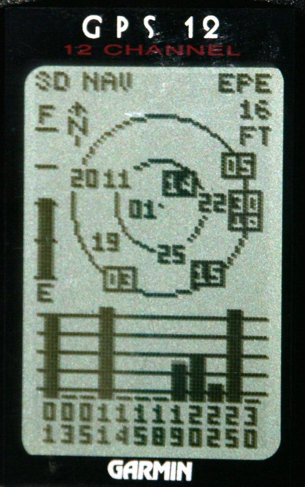
24 The GPS Satellite Page

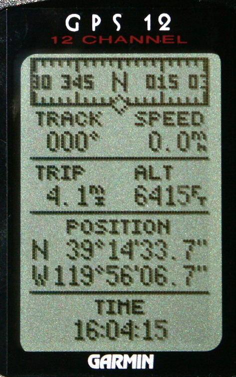
25 What is your location?
26 Recommend GPS Books The GPS Handbook - A Guide for the Outdoors GPS Made Easy - Using Global Positioning Systems in the Outdoors Outdoor Navigation with GPS
27 Website Links See the white paper for a list of website that can provide additional GPS information Also use Yahoo or Google search engines - For GPS books - For GPS receivers
28 GPS + FRS Radios There is a family of combined functions There are two key combined benefits #1 You have one less electronic device to carry #2 When you talk, your position is broadcast to all the other radios - With map display, can see each other s location

29 GPS on Instrument Panel

30 A GPS Mounting Bracket

31 Spooner Summit 10 Sec Grid

32 Spooner Summit 1 min Grid
33 Google Earth & Tracks Google has a great program called Earth Can zoom in or out on any area Can rotate close to the horizon Can rotate to any direction, N, S, E or W Can plot your snowmobile tracks Can mark specific way points

34 Tracks at Little Truckee Summit plotted on a Topo Map

35 Same tracks at LTS plotted on Google Earth
36 Thanks for Coming Hope you enjoyed the presentation Please remember: Safety for you and your snowmobile buddies should be #1 priority Come back home alive so you can enjoy another snowmobile ride in the future
HOW CAN A GPS HELP? WHY A GPS? HOW DOES A GPS WORK?
 HOW CAN A GPS HELP? WHY A GPS? HOW DOES A GPS WORK? WHO INVENTED GPS? About The GPS Satellites There are 24-32 different satellites in space 2005 They orbit the Earth every 12 hours in 6 different planes
GPS 101. An Introduction to Using a GPS Receiver
 GPS 101 An Introduction to Using a GPS Receiver The goal of this presentation if to provide a basic understanding of what is GPS, how it works, provide some basic terminology and to provide ideas on how
Dr. Heather Petcovic TECHNOLOGY FOR TEACHING: HANDHELD GPS AND EARTHCACHING
 TECHNOLOGY FOR TEACHING: HANDHELD GPS AND EARTHCACHING Dr. Heather Petcovic Department of Geosciences and the Mallinson Institute for Science Education TECHNOLOGY FOR TEACHING: HANDHELD GPS AND EARTHCACHING
Introduction to Aerial Photographs and Topographic maps (Chapter 7, 9 th edition) or (chapter 3, 8 th edition)
 or (chapter 3, 8 th edition)") GEOLOGY 306 Laboratory Instructor: TERRY J. BOROUGHS NAME: Introduction to Aerial Photographs and Topographic maps (Chapter 7, 9 th edition) or (chapter 3, 8 th edition) For this assignment you will require:
GEOLOGY 306 Laboratory Instructor: TERRY J. BOROUGHS NAME: Introduction to Aerial Photographs and Topographic maps (Chapter 7, 9 th edition) or (chapter 3, 8 th edition) For this assignment you will require:
The GPS Classroom. Jared Covili
 The GPS Classroom Jared Covili 1/17/06 2 The GPS Classroom Jared Covili jcovili@media.utah.edu (801) 585-5667 The GPS Classroom is a 2-day course that provides participants with the basic knowledge of
Introduction to Aerial Photographs and Topographic maps (Chapter 3)
") GEOLOGY 306 Laboratory Instructor: TERRY J. BOROUGHS NAME: Introduction to Aerial Photographs and Topographic maps (Chapter 3) For this assignment you will require: a calculator and metric ruler. Objectives:
GEOLOGY 306 Laboratory Instructor: TERRY J. BOROUGHS NAME: Introduction to Aerial Photographs and Topographic maps (Chapter 3) For this assignment you will require: a calculator and metric ruler. Objectives:
GPS Apps for Smart Phone and PC YHA Bushwalking Club Night Presentation. Lutz Lademann May 2016
 GPS Apps for Smart Phone and PC YHA Bushwalking Club Night Presentation Lutz Lademann walks@lademann.de May 2016 Content How Does GPS Work What are GPX Files Where to Find GPX Files/Tracks/Walks How to
3. GPS receiver instruction cards GPS receivers
 Subject: GPS (& how its applications with Agriculture) Date: June 10, 2010 Lesson Title: Where exactly are we? Grade Level: Upper Elementary/Middle School Time period: 60-90 minutes Lesson Objectives:
Modern Navigation. Thomas Herring
 12.215 Modern Navigation Thomas Herring Summary of Last class Satellite Orbits Treat the basic description and dynamics of satellite orbits Major perturbations on GPS satellite orbits Sources of orbit
Deep Sea Salvage Operations
 Deep Sea Salvage Operations Dr. Alok K. Verma & Ameya Erande Lean Institute - ODU 1 Deep Sea Salvage - Description of Module Shipwrecks are salvaged world wide for accident investigation, antique exploration
Essentials of Navigation
 Essentials of Navigation Latitudes & Longitudes, GPS, and more For Race Officers and Mark Boat Operators by Ed Bottrell eztrap Developer Glen Haven, Nova Scotia CANADA v13 email: info@bottrell.ca Website:
12.S56 GPS: Where Are You? Fall 2008
 MIT OpenCourseWare http://ocw.mit.edu 12.S56 GPS: Where Are You? Fall 2008 For information about citing these materials or our Terms of Use, visit: http://ocw.mit.edu/terms. 12S56 GPS Basics of Handheld
BGRI Stem Rust Survey Protocol. Overview of Field Survey Procedure
 Overview of Field Survey Procedure 1. Ensure survey team have all items on check-list before departure 2. Travel to 1 st survey location 3. At survey location switch on GPS 4. Wait until GPS receives satellite
What is it? History. Other systems. How does it work? Trilateration GEOG 201 4/28/2010. Instructor: Pesses 1. {06} The Global Positioning System
 What is it? {06} The Global Positioning System G.P.S. = Global Positioning System Different from G.I.S. (Geographic Information Systems) Map Interpretation & GPS Spring 2010 M. Pesses History Conceived
Lab #4 Topographic Maps and Aerial Photographs
 Lab #4 Topographic Maps and Aerial Photographs Purpose To familiarize you with using topographic maps. Visualizing the shape of landforms from topographic maps is an essential skill in geology. Proficiency
Lecture # 7 Coordinate systems and georeferencing
 Lecture # 7 Coordinate systems and georeferencing Coordinate Systems Coordinate reference on a plane Coordinate reference on a sphere Coordinate reference on a plane Coordinates are a convenient way of
Chapter 6 Navigation and Field Mapping
 Chapter 6 Navigation and Field Mapping In this chapter you will learn about: Orienting maps Measuring a bearing on a map Plotting points on a map using latitude/longitude Plotting points on a map using
GPS (GLOBAL POSITIONING SYSTEM)
") GPS (GLOBAL POSITIONING SYSTEM) What is GPS? GPS, standing for Global Positioning System, is becoming common nowadays. Following is a brief introduction. The American Defense Department developed GPS originally
GPS (GLOBAL POSITIONING SYSTEM) What is GPS? GPS, standing for Global Positioning System, is becoming common nowadays. Following is a brief introduction. The American Defense Department developed GPS originally
2.017 DESIGN OF ELECTROMECHANICAL ROBOTIC SYSTEMS Fall 2009 Lab 3: GPS and Data Logging. September 28, 2009 Dr. Harrison H. Chin
 2.017 DESIGN OF ELECTROMECHANICAL ROBOTIC SYSTEMS Fall 2009 Lab 3: GPS and Data Logging September 28, 2009 Dr. Harrison H. Chin Formal Labs 1. Microcontrollers Introduction to microcontrollers Arduino
Geodesy, Geographic Datums & Coordinate Systems
 Geodesy, Geographic Datums & Coordinate Systems What is the shape of the earth? Why is it relevant for GIS? 1/23/2018 2-1 From Conceptual to Pragmatic Dividing a sphere into a stack of pancakes (latitude)
GPS: The Basics. Darrell R. Dean, Jr. Civil and Environmental Engineering West Virginia University. Expected Learning Outcomes for GPS
 GPS: The Basics Darrell R. Dean, Jr. Civil and Environmental Engineering West Virginia University Expected Learning Outcomes for GPS Explain the acronym GPS Name 3 important tdt dates in history of GPS
GLOBAL POSITIONING SYSTEMS
 GLOBAL POSITIONING SYSTEMS GPS & GIS Fall 2017 Global Positioning Systems GPS is a general term for the navigation system consisting of 24-32 satellites orbiting the Earth, broadcasting data that allows
GPS Training
 GPS Setup for use at Home & Abroad When a new GPS leaves the factory the default setting is for central USA and the position format & map datums set to latitude & longitude. All of which is fine for factory
Latest Press Release. reading passages about survival with questions
 corp@stantec.com Latest Press Release reading passages about survival with questions S To aim your dish, you'll need to know your azimuth and elevation coordinates. Azimuth relates to the left-to-right
GPS & DGPS Made Easy
 NOTE GPS & DGPS Made Easy This booklet is intended to provide mariners with a basic understanding of the Global Positioning System (GPS) and the Differential Global Positioning System (DGPS), and to assist
UNITED NATIONS UNIVERSITY Institute for Environment & Human Security (UNU-EHS) Bonn, Germany
 Bonn, Germany") UNITED NATIONS UNIVERSITY Institute for Environment & Human Security (UNU-EHS) Bonn, Germany Introduction to GPS technology Prof. Dr. Jörg Szarzynski Education Programme Director Head of Section EduSphere
UNITED NATIONS UNIVERSITY Institute for Environment & Human Security (UNU-EHS) Bonn, Germany Introduction to GPS technology Prof. Dr. Jörg Szarzynski Education Programme Director Head of Section EduSphere
OPERATOR'S MANUAL. GPS Navigator GP-33. Model.
 GPS Navigator Model GP-33 OPERATOR'S MANUAL www.furuno.com (Elemental Chlorine Free) The paper used in this manual is elemental chlorine free. 9-52, Ashihara-cho, Nishinomiya, 662-8580, JAPAN FURUNO Authorized
2. CHARTS. 2.1 Chart projections Mercator projections. Maps which are used for marine or aeronautical navigation are called charts.
 Maps which are used for marine or aeronautical navigation are called charts. In Canadian waters, mariners are required to carry the latest editions of the paper charts, at the largest scale available (see
Global Positioning Systems (GPS) Trails: the achilles heel of mapping from the air / satellites
 Trails: the achilles heel of mapping from the air / satellites") Global Positioning Systems (GPS) Trails: the achilles heel of mapping from the air / satellites Google maps updated regularly by local users using GPS Also: http://openstreetmaps.org GPS applications
Global Positioning Systems (GPS) Trails: the achilles heel of mapping from the air / satellites Google maps updated regularly by local users using GPS Also: http://openstreetmaps.org GPS applications
Introduction Getting Started
 Introduction Getting Started 1. If you haven t done it already, download Google Earth TM 5.0 from earth.google.com and install it on your computer. 2. If you haven t done it already, download the Essentials_3E_Geotours.kmz
TDS Survey Pro CE Version Setup RTK Base on known NAD83/WGS84 Point: Mapping Plane Geoid99 Modeling.
 TDS Survey Pro CE Version 2.1.8 Setup RTK Base on known NAD83/WGS84 Point: Mapping Plane Geoid99 Modeling. Pre-load known NAD83 State Plane Coordinates and appropriate NGS Geoid 99/96 data files into the
GPS. La*tude Longitude. Global Posi*oning Systems
 GPS La*tude Longitude Global Posi*oning Systems Two topics today La*tude and Longitude Loca*ng things on the surface of the earth with coordinates GPS Global Posi*oning System Using satellites and receivers
GPS Position Sensor PS-2175
 In s tr u c ti o n M a n u a l 012-09919A GPS Position Sensor PS-2175! Table of Contents Contents Introduction........................................................... 3 Theory of Operation....................................................
Appendix B The Garmin GPS Map 76 Receiver: Features, Functions, Setup, and Quality of Position
 Appendix B The Garmin GPS Map 76 Receiver: Features, Functions, Setup, and Quality of Position Garmin GPS Map76 Features Specifications Weight: 7.5 ounces No. channels: 12 parallel Antenna type: Quad Helix
NR402 GIS Applications in Natural Resources
 NR402 GIS Applications in Natural Resources Lesson 5 GPS/GIS integration Global Positioning System (GPS)..a global navigation system that everyone can use What is GPS? How does it work? How accurate is
Understanding and using your GPS Receiver (Version date: 2 February 2007)
") Understanding and using your GPS Receiver (Version date: 2 February 2007) Authors: Helen Durham and Katherine Arrell School of Geography, University of Leeds, UK Contents 1. Aims...2 2. Learning Outcomes...2
Understanding and using your GPS Receiver (Version date: 2 February 2007) Authors: Helen Durham and Katherine Arrell School of Geography, University of Leeds, UK Contents 1. Aims...2 2. Learning Outcomes...2
Land Navigation / Map Reading
 Land Navigation / Map Reading What is the Field Manual for map reading and land navigation? FM 3-25.26 What are the basic colors of a map, and what does each color represent? Black - Indicates cultural
Location Tracking. Current Technologies 1/19/2011. Not one, single technology Convergence of several technologies. Systems for
 Don Mason Associate Director Copyright 2011 National Center for Justice and the Rule of Law All Rights Reserved Location Tracking Not one, single technology Convergence of several technologies Systems
GPS Geodetic Reference System WGS 84
 GPS Geodetic Reference System WGS 84 International Committee on GNSS Working Group D Saint Petersburg, Russia 16 September 2009 Barbara Wiley National Geospatial-Intelligence Agency United States of America
rino 600 series quick start manual
 rino 600 series quick start manual Getting Started Keys warning See the Important Safety and Product Information guide in the product box for product warnings and other important information. When using
Presented by: Mark Landress WB5ANN
 Presented by: Mark Landress WB5ANN Distribution of Licensed Amateur Radio Operators in the US 2016 Courtesy ARRL Ham Radio Mapping - WB5ANN 1 Outline Basics Latitude and Longitude Map Types and Projections
Digital Surveillance Devices?
 Technology Framework Tracking Technologies Don Mason Associate Director Digital Surveillance Devices? Digital Surveillance Devices? Secure Continuous Remote Alcohol Monitor SCRAM Page 1 Location Tracking
CHAPTER 2 GEODESY AND DATUMS IN NAVIGATION
 CHAPTER 2 GEODESY AND DATUMS IN NAVIGATION GEODESY, THE BASIS OF CARTOGRAPHY 200. Definition Geodesy is the application of mathematics to model the size and shape of the physical earth, enabling us to
NGA s Support for Positioning and Navigation
 NGA s Support for Positioning and Navigation PNT Symposium 6 November 2007 Barbara Wiley NATIONAL GEOSPATIAL-INTELLIGENCE AGENCY What is NGA and What Do We Do? National Geospatial-Intelligence Agency (NGA)
Appendix B: Descriptions of Virtual Instruments (vis) Implemented
 Implemented") Appendix B: Descriptions of Virtual Instruments (vis) Implemented Overview of vis Implemented This appendix contains a brief description of each vi implemented in this project. Labview implements functions
Appendix B: Descriptions of Virtual Instruments (vis) Implemented Overview of vis Implemented This appendix contains a brief description of each vi implemented in this project. Labview implements functions
Digital surveillance devices?
 Technology Framework Tracking Technologies Don Mason Associate Director Copyright 2011 National Center for Justice and the Rule of Law All Rights Reserved Digital surveillance devices? Digital surveillance
Using Handheld Global Positioning System Receivers for the Wheat Objective Yield Survey
 United States Department of Agriculture Using Handheld Global Positioning System Receivers for the Wheat Objective Yield Survey National Agricultural Statistics Service Michael W. Gerling Research and
KBOS RNAV VISUAL Rwy 33L
 Point Of Contact ATC Facility Name - POC's Name - Joe DeVito Telephone Number - 718-709-2264 FAX Number - 718-709-2280 Email Address - joseph.devito@jetblue.com TARGETS Distribution Package Page 1 of 6
GPS Technical Overview N5TWP NOV08. How Can GPS Mislead
 GPS Technical Overview How Can GPS Mislead 1 Objectives Components of GPS Satellite Acquisition Process Position Determination How can GPS Mislead 2 Components of GPS Control Segment Series of monitoring
TEST YOUR SATELLITE NAVIGATION PERFORMANCE ON YOUR ANDROID DEVICE GLOSSARY
 TEST YOUR SATELLITE NAVIGATION PERFORMANCE ON YOUR ANDROID DEVICE GLOSSARY THE GLOSSARY This glossary aims to clarify and explain the acronyms used in GNSS and satellite navigation performance testing
MOBILE COMPUTING 1/28/18. Location, Location, Location. Overview. CSE 40814/60814 Spring 2018
 MOBILE COMPUTING CSE 40814/60814 Spring 018 Location, Location, Location Location information adds context to activity: location of sensed events in the physical world location-aware services location
Sarah Steele, Curriculum Materials/Media Librarian, Campbell University Karen Waller, Media Specialist, Timber Drive Elementary School
 Sarah Steele, Curriculum Materials/Media Librarian, Campbell University Karen Waller, Media Specialist, Timber Drive Elementary School These are a group of 24 satellites started in 1978 by the US Navy
Installation and Operation Manual
 www.navman.com Tracker 5430/5430i Pilot 3380 C H A RA TU PT LO OP T I TL EO R T Installation and Operation Manual FCC Statement Note: This equipment has been tested and found to comply with the limits
A-CR-CCP-703/PF-001 CHAPTER 13 PO 322 PLOT LOCATION ON A TOPOGRAPHICAL MAP USING A GLOBAL POSITIONING SYSTEM RECEIVER
 CHAPTER 13 PO 322 PLOT LOCATION ON A TOPOGRAPHICAL MAP USING A GLOBAL POSITIONING SYSTEM RECEIVER ROYAL CANADIAN ARMY CADETS SILVER STAR INSTRUCTIONAL GUIDE SECTION 1 EO M322.01 REVIEW RED STAR NAVIGATION
Yield Monitoring Systems: Understanding how we Estimate Yield
 Monitoring Systems: Understanding how we Estimate Joe D. Luck, Precision Agriculture Engineer University of Nebraska-Lincoln Extension Department of Biological Systems Engineering Discussion Topics monitor
GPS Module AGP3363. Product Datasheet & Design Guide <V1.0>
 GPS Module AGP3363 Product Datasheet & Design Guide AMOD Technology Co.,LTD Subject to changes in technology, design and availability URL: http://www.amod.com.tw Add. 8F., No. 46, Lane 10, Jihu
Lab Exercise #3 Introduction to the Digital Globe Google Earth Geo210 Rockland Community College Professor Paluzzi Due Date:
 Lab Exercise #3 Introduction to the Digital Globe Google Earth Geo210 Rockland Community College Professor Paluzzi Due Date: The Digital Globe: Google Earth 30 Points Purpose: This lab will introduce the
BACHELOR'S THESIS. Indoor Positioning System. Robert Brännström BACHELOR OF SCIENCE PROGRAMME COMPUTER ENGINEERING.
 2001:40 HIP BACHELOR'S THESIS Indoor Positioning System Robert Brännström BACHELOR OF SCIENCE PROGRAMME COMPUTER ENGINEERING Skellefteå Campus 2001: 40 HIP ISSN: 1404-5494 ISRN:LTU - HIP - EX -- 01/40
GR16 GPS Receiver Accessory Manual _B
 GR16 GPS Receiver Accessory Manual 531478-1_B Thank You! Thank you for choosing Humminbird, America's #1 name in fishfinders. Humminbird has built its reputation by designing and manufacturing top-quality,
SITE SURVEY REPORT. Contract number: Customer: Site Name: Site Location: (City, Country) Sub-contractor: Requested by TSS/Project Manager Date:
 Sub-contractor: Requested by TSS/Project Manager Date:") Contract number: Customer: Site Name: Site Location: (City, Country) SITE SURVEY REPORT Sub-contractor: Requested by TSS/Project Manager Date: Survey Date: Surveyor: Survey: CONTRACT NUMBER: SITE Survey
Contract number: Customer: Site Name: Site Location: (City, Country) SITE SURVEY REPORT Sub-contractor: Requested by TSS/Project Manager Date: Survey Date: Surveyor: Survey: CONTRACT NUMBER: SITE Survey
Line and polygon features can be created via on-screen digitizing.
 This module explains how GPS works, sources of error, and error correction using real time or post processing differential correction. Cost and accuracy of different grades of GPS units are also part of
PRE-LAB for: Introduction to Aerial Photographs and Topographic maps (Ch. 3)
") GEOLOGY 306 Laboratory Instructor: TERRY J. BOROUGHS NAME: PRE-LAB for: Introduction to Aerial Photographs and Topographic maps (Ch. 3) For this assignment you will require: a calculator and metric ruler.
GEOLOGY 306 Laboratory Instructor: TERRY J. BOROUGHS NAME: PRE-LAB for: Introduction to Aerial Photographs and Topographic maps (Ch. 3) For this assignment you will require: a calculator and metric ruler.
CRITICAL FREQUENCY By Marcel H. De Canck, ON5AU
 CRITICAL FREQUENCY By Marcel H. De Canck, ON5AU Before reading onward, it would be good to refresh your knowledge about refraction rules in the section on Refraction of the earlier "Wave Propagation Direction
The topic we are going to see in this unit, the global positioning system, is not directly related with the computer networks we use everyday, but it
 The topic we are going to see in this unit, the global positioning system, is not directly related with the computer networks we use everyday, but it is indeed a kind of computer network, as the specialised
BACKGROUND INFORMATION
 Build an Island INTRODUCTION For this assignment, you will be creating a topographic map and three-dimensional model of a fictional island that you have designed. You will start by exploring some basic
Legal Description & Site Plan Requirements and Layouts
 Legal Description & Site Plan Requirements and Layouts Plot Plan * A plot plan shows the location of a house from an aerial view. * The site plan, also known as a plot or lot plan includes: 1. Site plan
Produced by Mr B Ward (Head of Geography PGHS)
") Getting to Know Google Earth The following diagram describes some of the features available in the main window of Google Earth. 9. Sun - Click this to display sunlight across the landscape. 1. Search panel
Getting to Know Google Earth The following diagram describes some of the features available in the main window of Google Earth. 9. Sun - Click this to display sunlight across the landscape. 1. Search panel
TDS Ranger Survey Pro CE Version RTK Base on known Control Point. RTK Rover - Localization with Control Points.
 TDS Ranger Survey Pro CE Version 2.1.8 RTK Base on known Control Point. RTK Rover - Localization with Control Points. Pre-load control Coordinates and appropriate NGS Geoid 99/96 data files into the Ranger
Coordinates, Datums, and Map Projection
 Coordinates, Datums, and Map Projection Two views on the World Intersect at 90 o angles Latitude/ Longitude is a Spherical System Acceptable latitudes/longitudes i) W125 o 27 33 ii) N92 o 45 12 iii)
GNSS & Coordinate Systems
 GNSS & Coordinate Systems Matthew McAdam, Marcelo Santos University of New Brunswick, Department of Geodesy and Geomatics Engineering, Fredericton, NB May 29, 2012 Santos, 2004 msantos@unb.ca 1 GNSS GNSS
Introduction to the Global Positioning System
 GPS for ICS - 2003 Introduction to the Global Positioning System Pre-Work Pre-Work Objectives Describe at least three sources of GPS signal error, and ways to mitigate or reduce those errors. Identify
A-CR-CCP-803/PF-001 CHAPTER 14 PO 337 DEMONSTRATE AIR NAVIGATION SKILLS
 CHAPTER 14 PO 337 DEMONSTRATE AIR NAVIGATION SKILLS ROYAL CANADIAN AIR CADETS PROFICIENCY LEVEL THREE INSTRUCTIONAL GUIDE SECTION 1 EO M337.01 MEASURE DISTANCE ALONG A ROUTE Total Time: 30 min PREPARATION
Introduction to NAVSTAR GPS
 Introduction to NAVSTAR GPS Charlie Leonard, 1999 (revised 2001, 2002) The History of GPS Feasibility studies begun in 1960 s. Pentagon appropriates funding in 1973. First satellite launched in 1978. System
36. Global Positioning System
 36. Introduction to the Global Positioning System (GPS) Why do we need GPS? Position: a basic need safe sea travel, crowed skies, resource management, legal questions Positioning: a challenging job local
GNSS 101 Bringing It Down To Earth
 GNSS 101 Bringing It Down To Earth Steve Richter Frontier Precision, Inc. UTM County Coordinates NGVD 29 State Plane Datums Scale Factors Projections Session Agenda GNSS History & Basic Theory Coordinate
2. (8pts) If θ is an acute angle, find the values of all the trigonometric functions of θ given
 If θ is an acute angle, find the values of all the trigonometric functions of θ given") Trigonometry Joysheet 1 MAT 145, Spring 2017 D. Ivanšić Name: Covers: 6.1, 6.2 Show all your work! 1. 8pts) If θ is an acute angle, find the values of all the trigonometric functions of θ given that sin
Trigonometry Joysheet 1 MAT 145, Spring 2017 D. Ivanšić Name: Covers: 6.1, 6.2 Show all your work! 1. 8pts) If θ is an acute angle, find the values of all the trigonometric functions of θ given that sin
Review Test 1. MULTIPLE CHOICE. Choose the one alternative that best completes the statement or answers the question.
 Review Test 1 MULTIPLE CHOICE. Choose the one alternative that best completes the statement or answers the question. Convert the angle to a decimal in degrees. Round the answer to two decimal places. 1)
Nikon D7000 Camera Kit
 Nikon D7000 Camera Kit -Checklist and Operations Manual- July 31, 2013 SRQ Composite Squadron, FLWG, Civil Air Patrol Page 1 of 30 1.0 Equipment Pre-Mission Check 1.1 Open the camera case and verify the
Navigation Systems - Enroute. Nolan, Chap 2
 Navigation Systems - Enroute Nolan, Chap 2 1 En-route Navigation Visual Flight Rules Instrument Flight Rules Pilotage/Dead-Reckoning Land-based Space-based Aircraft-based Aeronautic Charts Forecast Wind
S a t e l l i t e T i m e a n d L o c a t i o n. N o v e m b e r John Fischer VP Advanced R&D
 STL - S a t e l l i t e T i m e a n d L o c a t i o n N o v e m b e r 2 0 1 7 John Fischer VP Advanced R&D jfischer@orolia.com 11/28/201 1 7 WHY AUGMENT GNSS? Recent UK Study Economic Input to UK of a
Addressing Issues with GPS Data Accuracy and Position Update Rate for Field Traffic Studies
 Addressing Issues with GPS Data Accuracy and Position Update Rate for Field Traffic Studies THIS FEATURE VALIDATES INTRODUCTION Global positioning system (GPS) technologies have provided promising tools
High Precision GNSS for Mapping & GIS Professionals
 High Precision GNSS for Mapping & GIS Professionals Agenda Address your needs for GNSS knowledge. GNSS Basics Satellite Ranging Fundamentals (Code $ Carrier) Differential Corrections (Post Processed $
EM-401. GPS ENGINE BOARD with Active Antenna PRODUCT GUIDE. Globalsat Technology Corporation (Taiwan)
") EM-401 GPS ENGINE BOARD with Active Antenna PRODUCT GUIDE Globalsat Technology Corporation (Taiwan) www.globalsat.com.tw USGlobalSat, Inc. (USA) www.usglobalsat.com Page 1 of 1 EM-401 GPS BOARD with Active
EM-401 GPS ENGINE BOARD with Active Antenna PRODUCT GUIDE Globalsat Technology Corporation (Taiwan) www.globalsat.com.tw USGlobalSat, Inc. (USA) www.usglobalsat.com Page 1 of 1 EM-401 GPS BOARD with Active
Seamless Navigation Demonstration Using Japanese Quasi-Zenith Satellite System (QZSS) and IMES
 and IMES") Seamless Navigation Demonstration Using Japanese Quasi-Zenith Satellite System (QZSS) and IMES ICG WG-B Application SG Meeting Munich, Germany March 12, 2012 Satellite Positioning Research and Application
Seamless Navigation Demonstration Using Japanese Quasi-Zenith Satellite System (QZSS) and IMES ICG WG-B Application SG Meeting Munich, Germany March 12, 2012 Satellite Positioning Research and Application
Principal Investigator Co-Principal Investigator Co-Principal Investigator Prof. Talat Ahmad Vice-Chancellor Jamia Millia Islamia Delhi
 Subject Paper No and Title Module No and Title Module Tag Geology Remote Sensing and GIS Concepts of Global Navigation Satellite RS & GIS XXXIII Principal Investigator Co-Principal Investigator Co-Principal
Basic Geodetics. Bobby Saleh Guidon Energy April 13, 2017
 Experts in Geomatics, Surveying, Positioning, Geospatial Data, and Mapping Sciences Basic Geodetics Bobby Saleh Guidon Energy b.saleh@guidonenergy.com April 13, 2017 The Earth is NOT flat Q: So what does
CHAPTER 2 GEODESY AND DATUMS IN NAVIGATION
 CHAPTER 2 GEODESY AND DATUMS IN NAVIGATION GEODESY, THE BASIS OF CARTOGRAPHY 200. Definition Geodesy is the science concerned with the exact positioning of points on the surface of the earth. It also involves
Managing Hydropower Project Boundaries & Exhibit Drawings
 - Managing Hydropower Project Boundaries & Exhibit Drawings C. Kirk Cover, P.E. NW Hydroelectric Assn Conference March 1-3, 2005 Federal Power Act Sec 3(11) Project Definition Federal Power Act defines
Chapter 3 Solution to Problems
 Chapter 3 Solution to Problems 1. The telemetry system of a geostationary communications satellite samples 100 sensors on the spacecraft in sequence. Each sample is transmitted to earth as an eight-bit
APPENDIX C VISUAL AND NAVIGATIONAL AIDS
 VISUAL AND NAVIGATIONAL AIDS APPENDIX C VISUAL AND NAVIGATIONAL AIDS An integral part of the airport system is the visual and navigational aids provided to assist pilots in navigating both on the airfield
Global Positioning System
 Global Positioning System Physics 1010 Term Paper Adrianne Bernardo 2012 Global Positioning System (GPS) Have you ever found yourself out in the middle of a marsh, phragmites 10 feet tall all around you
LinkAlign-360FER Set-up and Operation Manual
 LinkAlign-360FER Set-up and Operation Manual Proprietary, Nextmove Technologies Page 1 Proprietary, Nextmove Technologies Page 2 Table of Contents General Notes:... 4 Description of items included with
Nebraska 4-H Robotics and GPS/GIS and SPIRIT Robotics Projects
 Name: Club or School: Robots Knowledge Survey (Pre) Multiple Choice: For each of the following questions, circle the letter of the answer that best answers the question. 1. A robot must be in order to
GPS Errors. Figure 1. Four satellites are required to determine a GPS position.
 Expl ai ni nggps:thegl obalposi t i oni ngsyst em since a minimum of four satellites is required to calculate a position (Fig 1). However, many newer GPS receivers are equipped to receive up to 12 satellite
Cooperation Agreements for SAR Service and COSPAS-SARSAT
 SAR/NAM/CAR/SAM IP/15 International Civil Aviation Organization 07/05/09 Search and Rescue (SAR) Meeting for the North American, Caribbean and South American Regions (SAR/NAM/CAR/SAM) (Puntarenas, Costa
How do you find a place on a globe? How do you look up a place based on latitude and longitude?
 Why are globes tilted? Most globes are made to tilt at an angle of 23.5º to match the actual tilt of the earth in relationship to our sun. Incidentally, it is this tilting of the earth relative to the
IEFIS GPS manual Applicable to iefis G3 including Lite versions Firmware or later
 IEFIS GPS manual Applicable to iefis G3 including Lite versions Firmware 1.0.3.5 or later Page 1 Table of Contents General...3 GPS sources...3 Internal GPS...3 NMEA GPS...3 ARINC GPS...3 CAN based GPS...3
Lab #8: Topographic Map Lab
 NAME: LAB TIME: TA NAME: Lab #8: Topographic Map Lab Topography is the shape of the land. Topographic maps are used to aid in the visualization of the shape of the land. Topographic maps include the accurate
NMEA2000- Par PGN. Mandatory Request, Command, or Acknowledge Group Function Receive/Transmit PGN's
 PGN Number Category Notes - Datum Local geodetic datum and datum offsets from a reference datum. T The Request / Command / Acknowledge Group type of 126208 - NMEA - Request function is defined by first
PRINCIPLES AND FUNCTIONING OF GPS/ DGPS /ETS ER A. K. ATABUDHI, ORSAC
 PRINCIPLES AND FUNCTIONING OF GPS/ DGPS /ETS ER A. K. ATABUDHI, ORSAC GPS GPS, which stands for Global Positioning System, is the only system today able to show you your exact position on the Earth anytime,