GPS Apps for Smart Phone and PC YHA Bushwalking Club Night Presentation. Lutz Lademann May 2016
|
|
|
- Georgiana Osborne
- 5 years ago
- Views:
Transcription

1 GPS Apps for Smart Phone and PC YHA Bushwalking Club Night Presentation Lutz Lademann May 2016
2 Content How Does GPS Work What are GPX Files Where to Find GPX Files/Tracks/Walks How to View/Modify/Create Tracks Online PC The Problem With the Elevation DEM GPS Smartphone Apps Turn-by-turn Navigation Compass Location Sharing Navigation
3 GPS How Does it Work?
4 GPS - Global Positioning System How does GPS work? What does assisted GPS work? How accurate is GSP? What s the difference to handheld dedicated navigation systems?


5 How Does GPS Work? 31 US GSP satellites in orbit over earth Each transmits signal containing ID Time/Date Position of satellite GPS receiver triangulates multiple satellite signals to determine position Since 2011, there are additional 24 Russian GLONASS satellites Modern GPS receivers support both systems

6 Assisted GSP Initial Time to First Fix (TTFF) can take 30s and more if only GPS data is used Assisted GSP uses location information from Cell Phone Base Stations or WiFi hotspots to roughly determine the position of the cell phone This allows quicker TTFF for the GPS receiver Works only in regions with cell phone coverage

7 Does GPS work without cell phone reception?
, smart phone typically do not support WAAS, the wide")
8 How Accurate is GPS? It depends: Best case is between 3m and 100m 3m if GPS receiver supports WAAS and WAAS is available (only North America), smart phone typically do not support WAAS, the wide area augmentation system (additional radio signal). 5-15m without WAAS, depending on number of satellites visible 100m with Selective Availability switched on

9 Accuracy, cont d GPS has weak signal Needs open sky does not work in closed rooms! Forest Canopy can have big impact Dense / wet clouds Reflection / Multipath problem
10 Coordinate Notations Degrees: DD.dddddd Degrees, Minutes: DD MM.mmm Degrees, Minutes, Seconds: DD MM SS.s Use +/- or N, S, E, W to indicate East/West and North/South Online Converter:


11 WGS84 / GDA94 GPS System uses WGS84 as global datum World Geodetic System from 1984 All smart phone navigation apps are using WGS84, too. Some offer conversions to local datums. Australia uses GDA94 as regional datum There is little actual difference between WGS84 and GDA94

12 The Earth A Perfect Sphere?

13 No, not really


14 GDA94 vs WGS84
15 Global/Regional Datums (Spatial Reference System / SRS) A datum is a system which allows the location of latitudes and longitudes (and heights) to be identified onto the surface of the Earth - ie onto the surface of a round object. Local or Regional Datums This diagram represents the Australian Geodetic Datum which was created in 1984 (AGD84 or AGD). Note how the Ellipsoid/Spheroid has been placed over Australia to best identify longitude and latitude. If you used this datum in the northern hemisphere longitude and latitude would be very poorly identified on the surface of the Earth.

16 Coordinate Notations - Example ,

17 Coordinate Notations, cont d Many Online Converter Sites, e.g. at
18 What Are GPX Files?
19 GPX Files GPX = GPS exchange Format Standard file format to exchange location data Can contain: Waypoints: Manually saved points of interest Track points: Automatically (periodically) recorded positions of where you walked
20 GPX Data Example <trkpt lat=" " lon=" "> <ele>72.29</ele><time> T04:33:02Z</time></trkpt> <trkpt lat=" " lon=" "><ele>72.33</ele><time> T04:33:08Z</time></trkpt> <trkpt lat=" " lon=" "><ele>72.43</ele><time> T04:33:14Z</time></trkpt>
21 GPX Data Example II A GPX file does not necessarily contain time and elevation data for track points. If the track points don t have elevation information, elevation gain / loss cannot be calculated from the GPX file itself If the track points do not have timestamps, then duration of the walk and speed (average, max, min) cannot be calculated From the difference between two trackpoints, distance and direction can be calculated

22 GPX Precision Depends on frequency: how often are track points recorded by application? How many seconds between recordings? How much distance between recordings? Error correction mechanisms: application can choose to ignore track points which are in all likelihood incorrect
23 Where to Find GPX Files / Walks?
24 Walk Directories Victoria Where2Walk Trailhiking Australia Open Spaces (Daywalks around Victoria, etc.) Other Search the Web but never trust the results, always try to verify reliability of data!

25 Where 2 Walk Bushwalking Vic

26 Trailhiking
27 How To View/Modify/Create GPX Files?
28 Online/Web Tools GPSies GPSVisualizer MapMyHike and many others search the web!

29 GPS Visualiser

30 Map My Hike
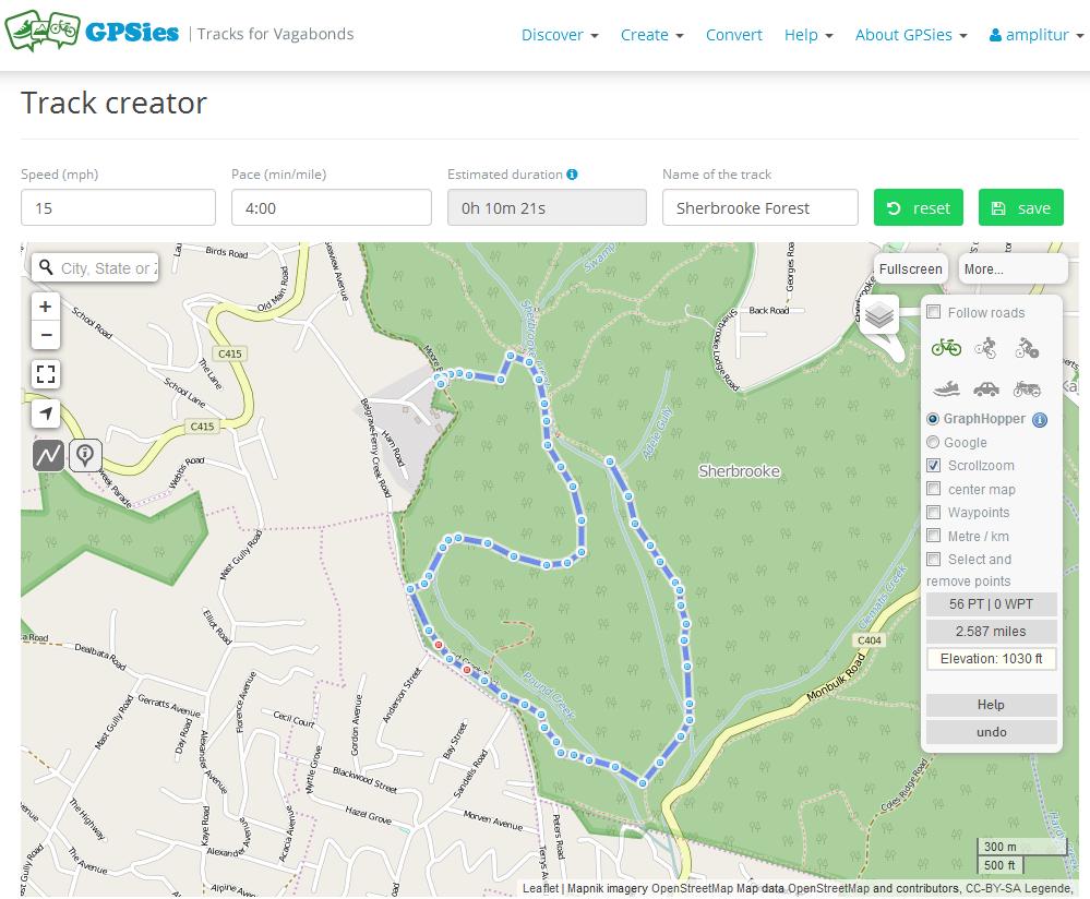
31 GPSies
32 PC (Windows/Mac/Linux) Tools GPS Tracks Editor Viking GPS and many others search the web!


33 PC: GPS Track Editor

34 PC/Mac/Linux: Viking GPS

35 So What's Your Problem with the Elevation?
36 Elevation & Digital Elevation Model GPS by design is highly inaccurate when it calculates elevation for a point Hence: You can never trust elevation data which is just gained from GPS signal Most online mapping tools are using DEM data to determine the elevation of track points and the overall elevation gain/loss for the track DEM stands for: Digital Elevation Model Some Smart Phone Apps use DEM data as well: they allow you to download DEM data for a specific area (e.g. the Android App Orux). Disadvantages: this uses a fair amount of storage space on your phone.
37 DEM: SRTM I SRTM is one of several possible DEM data sources for mapping applications. There many other sources for different regions of the world, but a lot of times they are not available to the general public, and in a lot of cases they only cover limited areas of the world or a country. SRTM is the most commonly used DEM data source for mapping applications today. The Shuttle Radar Topography Mission (SRTM) was an international research effort that obtained digital elevation models on a near-global scale from 56 S to 60 N The elevation models are arranged into tiles, each covering one degree of latitude and one degree of longitude, named according to their south western corners.

38 DEM: SRTM II Example for SRTM elevation tiles. DEM data is available for download at:
39 Elevation Gain/Loss Calculating elevation data for a GPX track from DEM sources like SRTM is more art than science. The result will never be fully precise Even when applied to the very same GPX track data, different applications will provide you with different results depending on the DEM source data they use and depending on how they calculate averages and how much smartness they apply to their algorithm. For the very same GPX track, Runkeeper gives 496m as total elevation gain, GPS Visualizer 525.6m and GPSies 435m.

40 Runkeeper: 496m

41 GPS Visualizer: 525.6m

42 GPSies: 435m


43 GPS Smartphone Apps
44 GPS Enabled Apps SatNav: Turn-by-turn navigation Compass Location Sharing Navigation
45 Turn-By-Turn Navigation (Driving) So that you get to the starting point of your walk these apps are available for Android and ios: Google Maps HERE Maps Recommended (Free of charge, can download maps per country for offline usage) TomTom Many others
46 Fitness/Tracking Applications Enable you to record activities / tracks Upload of tracks to social web site, view tracks Share with friends, set goals, etc. Examples: Runkeeper, MapMyRun, MapMyHike, Nike+, Runtastic, Strava Run, and many more Export GPX tracks later NOT suitable for navigation!

47 Example Fitness App: Runkeeper


48 Current Position and Direction iphone Compass App Android: GPS Status
49 Current Position Compass Apps will provide you with your current location Most of them allow you copy your location coordinates so that you can paste them into another application (text message, , etc.) Even if you rather use a printed map for navigation sometimes it can be extremely helpful to just identify your current position on your phone/gps device so that you then can identify your position on the map, using the geo coordinates grid system printed on all walking maps.


50 Location Sharing Glympse is an location sharing application for Android and ios. A big advantage: the one you are sharing you location with does not need a specific application or device to view your location any web browser will do. Apple ios 8 and higher offer the functionality to share your location with anyone you are having a text message conversation with. Many Chat applications like WhatsApp also allow to share your current location.
51 Navigation Apps Typical functionality of navigation apps: Determine your position Show your position on a map Download / import maps for offline usage Record the tracks you walk Keep record of all your activities Navigate to a destination (waypoint) Follow a recorded track Display a trip computer Share you position with others Share track with others

52 Should You Rely on Your Smart Phone for Outdoor Navigation?
53 Difference Between Navigation System and Smart Phone? Smart Phone is a multi-purpose computer, is neither shock-proof nor water-proof, has a very high power consumption, etc. A handheld Navigation System is specialised in outdoor navigation, the better models are shock and water proof, will work for several days before running out of power, have multiple antennas for better reception, special algorithms to handle the multipath problem, etc.
, printed maps Compass If walking far away from")
54 Can I Rely on a Outdoor Navigation System then? Always take laminated (protected), printed maps Compass If walking far away from civilization, take a PLB Personal Locator Beacon
55 Navigation Apps / Map Viewer Examples: Android: Orux Maps Free. Highly recommended! Avenza PDF Maps Free Gaia GPS Apple iphone GPS Motion X, about $2.50. Highly recommended! Avenza PDF Maps Gaia GPS
56 Map Data Online only: Google Maps Apple Maps Microsoft/Bing HERE Maps Open Street Map comes in different flavours, but all based on OSM map sources: OSM Street OSM Topo Mapnik Etc. Topology Maps: e.g. VicMaps Any print map scanned and calibrated

57 VicMap Topographic Maps

58 Scan & Geocode Maps Take any printed map to OfficeWorks and get it scanned in high resolution. OfficeWorks have large scanners, they can scan very large maps!


59 MAPC2MAP2 Use MAPC2MAPC to geo-calibrate scanned map file

60 Scan & Geocode Maps You can then export the geo-calibrated image file in different formats, suitable for different navigation apps Screenshot shows example of scanned Wilsons Prom app in Avenza PDF Maps
61 Thank You!
GPS for Snowmobilers. By Wayne Fischer. November 14, 2006
 GPS for Snowmobilers By Wayne Fischer November 14, 2006 Wayne@TahoeSnowmobiling.org Copy of White Paper & Presentation Both this presentation and the white paper are available on the www.tahoesnowmobiling.org
NR402 GIS Applications in Natural Resources
 NR402 GIS Applications in Natural Resources Lesson 5 GPS/GIS integration Global Positioning System (GPS)..a global navigation system that everyone can use What is GPS? How does it work? How accurate is
MODULE 7 LECTURE NOTES 3 SHUTTLE RADAR TOPOGRAPHIC MISSION DATA
 MODULE 7 LECTURE NOTES 3 SHUTTLE RADAR TOPOGRAPHIC MISSION DATA 1. Introduction Availability of a reasonably accurate elevation information for many parts of the world was once very much limited. Dense
Line and polygon features can be created via on-screen digitizing.
 This module explains how GPS works, sources of error, and error correction using real time or post processing differential correction. Cost and accuracy of different grades of GPS units are also part of
HOW CAN A GPS HELP? WHY A GPS? HOW DOES A GPS WORK?
 HOW CAN A GPS HELP? WHY A GPS? HOW DOES A GPS WORK? WHO INVENTED GPS? About The GPS Satellites There are 24-32 different satellites in space 2005 They orbit the Earth every 12 hours in 6 different planes
Global Positioning Systems (GPS) Trails: the achilles heel of mapping from the air / satellites
 Trails: the achilles heel of mapping from the air / satellites") Global Positioning Systems (GPS) Trails: the achilles heel of mapping from the air / satellites Google maps updated regularly by local users using GPS Also: http://openstreetmaps.org GPS applications
Global Positioning Systems (GPS) Trails: the achilles heel of mapping from the air / satellites Google maps updated regularly by local users using GPS Also: http://openstreetmaps.org GPS applications
GPS: The Basics. Darrell R. Dean, Jr. Civil and Environmental Engineering West Virginia University. Expected Learning Outcomes for GPS
 GPS: The Basics Darrell R. Dean, Jr. Civil and Environmental Engineering West Virginia University Expected Learning Outcomes for GPS Explain the acronym GPS Name 3 important tdt dates in history of GPS
GPS 101. An Introduction to Using a GPS Receiver
 GPS 101 An Introduction to Using a GPS Receiver The goal of this presentation if to provide a basic understanding of what is GPS, how it works, provide some basic terminology and to provide ideas on how
GLOBAL POSITIONING SYSTEMS
 GLOBAL POSITIONING SYSTEMS GPS & GIS Fall 2017 Global Positioning Systems GPS is a general term for the navigation system consisting of 24-32 satellites orbiting the Earth, broadcasting data that allows
Modern Navigation. Thomas Herring
 12.215 Modern Navigation Thomas Herring Summary of Last class Satellite Orbits Treat the basic description and dynamics of satellite orbits Major perturbations on GPS satellite orbits Sources of orbit
GEOGRAPHIC INFORMATION SYSTEMS Lecture 22: Field Mapping with GPS
 GEOGRAPHIC INFORMATION SYSTEMS Lecture 22: Field Mapping with GPS GPS Receivers - there are many GPS receivers on the market today - some receivers are relatively inexpensive (recreational grade receivers)
Radio Mobile. Software for Wireless Systems Planning
 Latin American Networking School (EsLaRed) Universidad de Los Andes Merida Venezuela Javier Triviño and E.Pietrosemoli Radio Mobile Software for Wireless Systems Planning About Radio Mobile It is a tool
Introduction to Geographic Information Science. Last Lecture. Today s Outline. Geography 4103 / GNSS/GPS Technology
 Geography 4103 / 5103 Introduction to Geographic Information Science GNSS/GPS Technology Last Lecture Geoids Ellipsoid Datum Projection Basics Today s Outline GNSS technology How satellite based navigation
Principles of Remote Sensing. Shuttle Radar Topography Mission S R T M. Michiel Damen. Dept. Earth Systems Analysis
 Principles of Remote Sensing Shuttle Radar Topography Mission S R T M Michiel Damen Dept. Earth Systems Analysis Contents Present problems with DEMs Advantage of SRTM Cell size Mission and system Radar
GPS (GLOBAL POSITIONING SYSTEM)
") GPS (GLOBAL POSITIONING SYSTEM) What is GPS? GPS, standing for Global Positioning System, is becoming common nowadays. Following is a brief introduction. The American Defense Department developed GPS originally
GPS (GLOBAL POSITIONING SYSTEM) What is GPS? GPS, standing for Global Positioning System, is becoming common nowadays. Following is a brief introduction. The American Defense Department developed GPS originally
Introduction to Mobile Sensing Technology
 Introduction to Mobile Sensing Technology Kleomenis Katevas k.katevas@qmul.ac.uk https://minoskt.github.io Image by CRCA / CNRS / University of Toulouse In this talk What is Mobile Sensing? Sensor data,
Global Positioning System (GPS)
") Global Positioning System (GPS) GPS enables users to easily record the location of natural and man-made features on the land. It allows users to identify where a photo or video is taken, revisit previously
Global Positioning System (GPS) GPS enables users to easily record the location of natural and man-made features on the land. It allows users to identify where a photo or video is taken, revisit previously
TEST YOUR SATELLITE NAVIGATION PERFORMANCE ON YOUR ANDROID DEVICE GLOSSARY
 TEST YOUR SATELLITE NAVIGATION PERFORMANCE ON YOUR ANDROID DEVICE GLOSSARY THE GLOSSARY This glossary aims to clarify and explain the acronyms used in GNSS and satellite navigation performance testing
The topic we are going to see in this unit, the global positioning system, is not directly related with the computer networks we use everyday, but it
 The topic we are going to see in this unit, the global positioning system, is not directly related with the computer networks we use everyday, but it is indeed a kind of computer network, as the specialised
IOT GEOLOCATION NEW TECHNICAL AND ECONOMICAL OPPORTUNITIES
 IOT GEOLOCATION NEW TECHNICAL AND ECONOMICAL OPPORTUNITIES Florian LECLERE f.leclere@kerlink.fr EOT Conference Herning 2017 November 1st, 2017 AGENDA 1 NEW IOT PLATFORM LoRa LPWAN Platform Geolocation
UNITED NATIONS UNIVERSITY Institute for Environment & Human Security (UNU-EHS) Bonn, Germany
 Bonn, Germany") UNITED NATIONS UNIVERSITY Institute for Environment & Human Security (UNU-EHS) Bonn, Germany Introduction to GPS technology Prof. Dr. Jörg Szarzynski Education Programme Director Head of Section EduSphere
UNITED NATIONS UNIVERSITY Institute for Environment & Human Security (UNU-EHS) Bonn, Germany Introduction to GPS technology Prof. Dr. Jörg Szarzynski Education Programme Director Head of Section EduSphere
What is it? History. Other systems. How does it work? Trilateration GEOG 201 4/28/2010. Instructor: Pesses 1. {06} The Global Positioning System
 What is it? {06} The Global Positioning System G.P.S. = Global Positioning System Different from G.I.S. (Geographic Information Systems) Map Interpretation & GPS Spring 2010 M. Pesses History Conceived
12.S56 GPS: Where Are You? Fall 2008
 MIT OpenCourseWare http://ocw.mit.edu 12.S56 GPS: Where Are You? Fall 2008 For information about citing these materials or our Terms of Use, visit: http://ocw.mit.edu/terms. 12S56 GPS Basics of Handheld
Radio Signal Prediction for Bang Goes the Theory
 Radio Signal Prediction for Bang Goes the Theory April 2012 Prepared by Professor Andrew Nix Department of Electrical and Electronic Engineering Bang Goes the Theory: Predicting Signal Levels to your Phone
GNSS & Coordinate Systems
 GNSS & Coordinate Systems Matthew McAdam, Marcelo Santos University of New Brunswick, Department of Geodesy and Geomatics Engineering, Fredericton, NB May 29, 2012 Santos, 2004 msantos@unb.ca 1 GNSS GNSS
BGRI Stem Rust Survey Protocol. Overview of Field Survey Procedure
 Overview of Field Survey Procedure 1. Ensure survey team have all items on check-list before departure 2. Travel to 1 st survey location 3. At survey location switch on GPS 4. Wait until GPS receives satellite
Utility of Sensor Fusion of GPS and Motion Sensor in Android Devices In GPS- Deprived Environment
 Utility of Sensor Fusion of GPS and Motion Sensor in Android Devices In GPS- Deprived Environment Amrit Karmacharya1 1 Land Management Training Center Bakhundol, Dhulikhel, Kavre, Nepal Tel:- +977-9841285489
GIS and Remote Sensing BIO8014. Data acquisition
 GIS and Remote Sensing BIO8014 Data acquisition Introduction Data can be manually created Data can be obtained from a wide range of providers both free and at cost Acquisition is key and must be accounted
36. Global Positioning System
 36. Introduction to the Global Positioning System (GPS) Why do we need GPS? Position: a basic need safe sea travel, crowed skies, resource management, legal questions Positioning: a challenging job local
GNSS 101 Bringing It Down To Earth
 GNSS 101 Bringing It Down To Earth Steve Richter Frontier Precision, Inc. UTM County Coordinates NGVD 29 State Plane Datums Scale Factors Projections Session Agenda GNSS History & Basic Theory Coordinate
Is neo-cadastral surveying on your smartphone feasible?
 Is neo-cadastral surveying on your smartphone feasible? School of Civil & Environmental Engineering Craig Roberts UNSW Paul Davis-Raiss, David Lofberg, Greg Goodman LandTeam Van der Vlugt, 2012 1 Cadastral
Location-Enhanced Computing
 Location-Enhanced Computing Today s Outline Applications! Lots of different apps out there! Stepping back, big picture Ways of Determining Location Location Privacy Location-Enhanced Applications Provide
BeFitter Apps Manual
 BeFitter Apps Manual Key features The apps BF Hiker, BF Cycle, BF XC Ski and BF Runner have 13 pages. You can toggle through these pages with the previous page and next page function. See the chapter User
Latest Press Release. reading passages about survival with questions
 corp@stantec.com Latest Press Release reading passages about survival with questions S To aim your dish, you'll need to know your azimuth and elevation coordinates. Azimuth relates to the left-to-right
MOBILE COMPUTING 1/28/18. Location, Location, Location. Overview. CSE 40814/60814 Spring 2018
 MOBILE COMPUTING CSE 40814/60814 Spring 018 Location, Location, Location Location information adds context to activity: location of sensed events in the physical world location-aware services location
NJDEP GPS Data Collection Standards for GIS Data Development
 NJDEP GPS Data Collection Standards for GIS Data Development Bureau of Geographic Information Systems Office of Information Resource Management April 24 th, 2017 Table of Contents 1.0 Introduction... 3
Galileo signal reflections used for monitoring waves and weather at sea
 Press Release Monday 26 th November 2007 Galileo signal reflections used for monitoring waves and weather at sea Surrey Satellite Technology Ltd (SSTL) and the University of Surrey have succeeded for the
SARscape s Coherent Changes Detection Tutorial
 SARscape s Coherent Changes Detection Tutorial Version 1.0 April 2018 1 Index Introduction... 3 Setting Preferences... 4 Data preparation... 5 Input data... 5 DEM Extraction... 5 Single Panels processing...
GEO 428: DEMs from GPS, Imagery, & Lidar Tuesday, September 11
 GEO 428: DEMs from GPS, Imagery, & Lidar Tuesday, September 11 Global Positioning Systems GPS is a technology that provides Location coordinates Elevation For any location with a decent view of the sky
Scalable geospatial 3D client applications in X3D - Interactive, online and in real-time
 Scalable geospatial 3D client applications in X3D - Interactive, online and in real-time Dipl.Inform.Univ Peter Schickel CEO Bitmanagement Software Vice President Web3D Consortium, Mountain View, USA OGC/Web3D
idocent: Indoor Digital Orientation Communication and Enabling Navigational Technology
 idocent: Indoor Digital Orientation Communication and Enabling Navigational Technology Final Proposal Team #2 Gordie Stein Matt Gottshall Jacob Donofrio Andrew Kling Facilitator: Michael Shanblatt Sponsor:
User Manual. This User Manual will guide you through the steps to set up your Spike and take measurements.
 User Manual (of Spike ios version 1.14.6 and Android version 1.7.2) This User Manual will guide you through the steps to set up your Spike and take measurements. 1 Mounting Your Spike 5 2 Installing the
Current status of Quasi-Zenith Satellite System. Japan Aerospace Exploration Agency QZSS Project Team
 Current status of Quasi-Zenith Satellite System Japan Aerospace Exploration Agency QZSS Project Team 1 Quasi-Zenith Satellite System The QZSS is a regional space-based PNT (Positioning, Navigation and
v Introduction Images Import images in a variety of formats and register the images to a coordinate projection WMS Tutorials Time minutes
 v. 10.1 WMS 10.1 Tutorial Import images in a variety of formats and register the images to a coordinate projection Objectives Import various types of image files from different sources. Learn how to work
GPS and Recent Alternatives for Localisation. Dr. Thierry Peynot Australian Centre for Field Robotics The University of Sydney
 GPS and Recent Alternatives for Localisation Dr. Thierry Peynot Australian Centre for Field Robotics The University of Sydney Global Positioning System (GPS) All-weather and continuous signal system designed
The GPS Classroom. Jared Covili
 The GPS Classroom Jared Covili 1/17/06 2 The GPS Classroom Jared Covili jcovili@media.utah.edu (801) 585-5667 The GPS Classroom is a 2-day course that provides participants with the basic knowledge of
366 Glossary. Popular method for scale drawings in a computer similar to GIS but without the necessity for spatial referencing CEP
 366 Glossary GISci Glossary ASCII ASTER American Standard Code for Information Interchange Advanced Spaceborne Thermal Emission and Reflection Radiometer Computer Aided Design Circular Error Probability
Lecture # 7 Coordinate systems and georeferencing
 Lecture # 7 Coordinate systems and georeferencing Coordinate Systems Coordinate reference on a plane Coordinate reference on a sphere Coordinate reference on a plane Coordinates are a convenient way of
Location-based technologies and navigation
 ES3 Lecture 8 Location-based technologies and navigation Location Awareness Technologies There are lots of location awareness technologies Give a location relative to a reference frame We will consider
How is GPS Used in Farming? Equipment Guidance Systems
 GPS Applications in Crop Production John Nowatzki, Extension Geospatial Specialist, Vern Hofman, Extension Ag Engineer Lowell Disrud, Assistant Professor, Kraig Nelson, Graduate Student Introduction The
Introduction to Datums James R. Clynch February 2006
 Introduction to Datums James R. Clynch February 2006 I. What Are Datums in Geodesy and Mapping? A datum is the traditional answer to the practical problem of making an accurate map. If you do not have
Choosing the best path:
 GEODESY Choosing the best path: Global to national coordinate transformations The paper demonstrates that differences of up to a few centimetres in each coordinate component can occur depending on the
MOBILE COMPUTING 1/29/18. Cellular Positioning: Cell ID. Cellular Positioning - Cell ID with TA. CSE 40814/60814 Spring 2018
 MOBILE COMPUTING CSE 40814/60814 Spring 2018 Cellular Positioning: Cell ID Open-source database of cell IDs: opencellid.org Cellular Positioning - Cell ID with TA TA: Timing Advance (time a signal takes
Real Time Indoor Tracking System using Smartphones and Wi-Fi Technology
 International Journal for Modern Trends in Science and Technology Volume: 03, Issue No: 08, August 2017 ISSN: 2455-3778 http://www.ijmtst.com Real Time Indoor Tracking System using Smartphones and Wi-Fi
di-gps Eco ProSumer digital images GPS receiver
 di-gps Eco ProSumer digital images GPS receiver Users Guide Ver 1.01 Please visit our website www.di-gps.com for the latest version of the user guide CONTENTS CONTENTS... 1 INTRODUCTION... 2 WARNING /
Location Based Technologies
 Location Based Technologies I have often wondered whether people really understand Location Based Services (LBS) technology and whether they would like a bit more insight into how exactly location based
Public or Private (2)
") // Public or Private () CCST90 Mar, 0 Dr. Hayden Kwok-Hay So Department of Electrical and Electronic Engineering The Making of Google Street View Google Street View Systematically capture photos of the
// Public or Private () CCST90 Mar, 0 Dr. Hayden Kwok-Hay So Department of Electrical and Electronic Engineering The Making of Google Street View Google Street View Systematically capture photos of the
Online Browser Streaming and Mobile-App Instructions
 Online Browser Streaming and Mobile-App Instructions for ios, ipad, and iphone March 06 ...Access Comics Plus: Library Edition Through Your Online Browser...Install App from App Store 4...Check Out and
Herecast: An Open Infrastructure for Location-Based Services using WiFi
 Herecast: An Open Infrastructure for Location-Based Services using WiFi Mark Paciga and Hanan Lutfiyya Presented by Emmanuel Agu CS 525M Introduction User s context includes location, time, date, temperature,
GPS Waypoint Application
 GPS Waypoint Application Kris Koiner, Haytham ElMiligi and Fayez Gebali Department of Electrical and Computer Engineering University of Victoria Victoria, BC, Canada Email: {kkoiner, haytham, fayez}@ece.uvic.ca
Image 1: old fashion leather albums. Image 2: slides and photo album
 The Terra Map How-To serie The geoalbum A bit of history A photographic album, or photo album, is a collection of photographs, generally in a book. Some book-form photo albums have compartments which the
The Global Positioning System
 The Global Positioning System 5-1 US GPS Facts of Note DoD navigation system First launch on 22 Feb 1978, fully operational in 1994 ~$15 billion (?) invested to date 24 (+/-) Earth-orbiting satellites
di-gps Eco ProSumer PS10-M digital images GPS receiver
 di-gps Eco ProSumer PS10-M digital images GPS receiver Users Guide Ver 1.03 Please visit our website www.di-gps.com for the latest version of the user guide CONTENTS CONTENTS... 1 INTRODUCTION... 2 WARNING
GNSS in the Arctic. by Arne Rinnan, Kongsberg Seatex AS. WORLD CLASS through people, technology and dedication
 GNSS in the Arctic by Arne Rinnan, Kongsberg Seatex AS WORLD CLASS through people, technology and dedication Outline Introduction Weather conditions Satellite coverage Aurora impact GNSS corrections Test
Appendix B The Garmin GPS Map 76 Receiver: Features, Functions, Setup, and Quality of Position
 Appendix B The Garmin GPS Map 76 Receiver: Features, Functions, Setup, and Quality of Position Garmin GPS Map76 Features Specifications Weight: 7.5 ounces No. channels: 12 parallel Antenna type: Quad Helix
GPS Milestones, cont. GPS Milestones. The Global Positioning Sytem, Part 1 10/10/2017. M. Helper, GEO 327G/386G, UT Austin 1. US GPS Facts of Note
 The Global Positioning System US GPS Facts of Note DoD navigation system First launch on 22 Feb 1978, fully operational in 1994 ~$15 billion (?) invested to date 24 (+/-) Earth-orbiting satellites (SVs)
Chapter 2 Outdoor Navigation
 Chapter 2 Outdoor Navigation 2.1 Introduction In this chapter, the technologies and techniques that are employed in outdoor navigation systems/services along with their features and users are discussed.
Understanding and using your GPS Receiver (Version date: 2 February 2007)
") Understanding and using your GPS Receiver (Version date: 2 February 2007) Authors: Helen Durham and Katherine Arrell School of Geography, University of Leeds, UK Contents 1. Aims...2 2. Learning Outcomes...2
Understanding and using your GPS Receiver (Version date: 2 February 2007) Authors: Helen Durham and Katherine Arrell School of Geography, University of Leeds, UK Contents 1. Aims...2 2. Learning Outcomes...2
A Quick Guide to ios 12 s New Measure App
 A Quick Guide to ios 12 s New Measure App Steve Sande For the past several years, Apple has been talking about AR augmented reality a lot. The company believes that augmented reality, which involves overlaying
Browser Streaming and Mobile-App Instructions for ios and Android tm
 Browser Streaming and Mobile-App Instructions for ios and Android tm February 07 Browser and Mobile-Device Instructions Browser Instructions... Access Comics Plus: Library Edition Through Your Browser
MEASURE Evaluation. Global Positioning System Toolkit
 Global Positioning System Toolkit Global Positioning System Toolkit This tool was made possible by support from the U.S. Agency for International Development (USAID) under terms of Cooperative Agreement
Addressing Issues with GPS Data Accuracy and Position Update Rate for Field Traffic Studies
 Addressing Issues with GPS Data Accuracy and Position Update Rate for Field Traffic Studies THIS FEATURE VALIDATES INTRODUCTION Global positioning system (GPS) technologies have provided promising tools
Introduction to the Global Positioning System
 GPS for Fire Management - 2004 Introduction to the Global Positioning System Pre-Work Pre-Work Objectives Describe at least three sources of GPS signal error, and identify ways to mitigate or reduce those
The Global Positioning Sytem II 10/19/2017
 The Global Positioning System II Field Experiments 10/19/2017 5-1 Mexico DGPS Field Campaign Cenotes in Tamaulipas, MX, near Aldama 10/19/2017 5-2 Are Cenote Water Levels Related? 10/19/2017 5-3 M. Helper,
ANALYSIS OF SRTM HEIGHT MODELS
 ANALYSIS OF SRTM HEIGHT MODELS Sefercik, U. *, Jacobsen, K.** * Karaelmas University, Zonguldak, Turkey, ugsefercik@hotmail.com **Institute of Photogrammetry and GeoInformation, University of Hannover,
Appendix D Brief GPS Overview
 Appendix D Brief GPS Overview Global Positioning System (GPS) Theory What is GPS? The Global Positioning System (GPS) is a satellite-based navigation system, providing position information, accurate to
Evaluating OTDOA Technology for VoLTE E911 Indoors
 Evaluating OTDOA Technology for VoLTE E911 Indoors Introduction As mobile device usage becomes more and more ubiquitous, there is an increasing need for location accuracy, especially in the event of an
Main topic of research: creation of tree line map. Scale: LANDSAT imagery (15-30 m spatial resolution)
") «Usage of geoportal information for mapping the northern forest line boundary» Mikhail Zimin NINA (Trondheim, Norway) Volkovo village, Zvenigorod (Moscow region), RUSSIA, 14-1717 April, 2009 Introduction
«Usage of geoportal information for mapping the northern forest line boundary» Mikhail Zimin NINA (Trondheim, Norway) Volkovo village, Zvenigorod (Moscow region), RUSSIA, 14-1717 April, 2009 Introduction
Location aware Apps Study
 Location aware Apps Study The purpose of this study is to survey the users' perceptions on location aware apps. This survey is composed of seven sections, the first six of which correspond to different
Quasi-Zenith Satellite System (QZSS)
") Transmission of Augmentation Corrections using the Japanese QZSS for Real-Time Precise Point Positioning in Australia Ken Harima 1, Suelynn Choy 1, Mazher Choudhury 2, Chris Rizos 2, Satoshi Kogure 3 1
Transmission of Augmentation Corrections using the Japanese QZSS for Real-Time Precise Point Positioning in Australia Ken Harima 1, Suelynn Choy 1, Mazher Choudhury 2, Chris Rizos 2, Satoshi Kogure 3 1
SURVEYORS BOARD OF QUEENSLAND. RTK GNSS for Cadastral Surveys. Guideline
 SURVEYORS BOARD OF QUEENSLAND RTK GNSS for Cadastral Surveys Guideline 30 November 2012 RTK GNSS for Cadastral Surveys General The Surveyors Board of Queensland has recently become aware of some issues
Introduction to Total Station and GPS
 Introduction to Total Station and GPS Dr. P. NANJUNDASWAMY Professor of Civil Engineering J S S Science and Technology University S J College of Engineering Mysuru 570 006 Introduction History GPS Overview
An introduction to RTKLIB open source GNSS processing software. Ryan Ruddick and Suelynn Choy
 An introduction to RTKLIB open source GNSS processing software Ryan Ruddick and Suelynn Choy 1 Resources RTKLIB homepage http://www.rtklib.com GIT repository https://github.com/tomojitakasu/rtklib/ Windows
Falsework & Formwork Visualisation Software
 User Guide Falsework & Formwork Visualisation Software The launch of cements our position as leaders in the use of visualisation technology to benefit our customers and clients. Our award winning, innovative
North America DE LORME. Terrain and Street Maps For DeLorme GPS and PCs. Product Description. The Most Complete Mapping Software for Recreation
 pormeo ToDE L DE LORME North America Terrain and Street Maps For DeLorme GPS and PCs Product Description Scout your destination as if you were there, anywhere in the U.S. and Canada, with up-to-date terrain
USER MANUAL FIELDBEE AND RTK BEE STATION FULL VERSION. WE PROVIDE ONLINE SUPPORT: VERSION 1.0.
 USER MANUAL FULL VERSION VERSION 1.0. FIELDBEE AND RTK BEE STATION WE PROVIDE ONLINE SUPPORT: support@efarmer.mobi info@efarmer.mobi CONTENTS TABLE OF CONTENTS INTRODUCTION... 3 3 WAYS OF USING FIELDBEE...
Using Handheld Global Positioning System Receivers for the Wheat Objective Yield Survey
 United States Department of Agriculture Using Handheld Global Positioning System Receivers for the Wheat Objective Yield Survey National Agricultural Statistics Service Michael W. Gerling Research and
DIFFERENTIAL GPS (DGPS) SITE OPERATIONAL ASSESSMENT
 SITE OPERATIONAL ASSESSMENT") DIFFERENTIAL GPS (DGPS) SITE OPERATIONAL ASSESSMENT NDGPS Site: Inspector(s): Date: Lincoln DGPS Site (764) LCDR Christian Hernaez, LT Mike Brashier 23JAN13 REFERENCES: (1) DGPS Concept of Operations,
DIFFERENTIAL GPS (DGPS) SITE OPERATIONAL ASSESSMENT NDGPS Site: Inspector(s): Date: Lincoln DGPS Site (764) LCDR Christian Hernaez, LT Mike Brashier 23JAN13 REFERENCES: (1) DGPS Concept of Operations,
LAB 1 METHODS FOR LOCATING YOUR FIELD DATA IN GEOGRAPHIC SPACE. Geog 315 / ENSP 428
 LAB 1 METHODS FOR LOCATING YOUR FIELD DATA IN GEOGRAPHIC SPACE Geog 315 / ENSP 428 Lab 1 Schedule Introduction to bio-physical field data collection (8:00-8:20am) Locating your data on the earth: NAVSTAR
Precise Positioning GNSS Applications
 Precise Point Positioning: Is the Era of Differential GNSS Positioning Drawing to an End? School of Surveying & Spatial Information Systems, UNSW, Sydney, Australia Chris Rizos 1, Volker Janssen 2, Craig
FAQ for City of Tacoma employees
 General: How do I update my contact information (address, phone number, email address)? How do I change my password? Forgot password Forgot username How do I favorite or bookmark the login page? Can I
9/12/2011. Training Course Remote Sensing Basic Theory & Image Processing Methods September 2011
 Training Course Remote Sensing Basic Theory & Image Processing Methods 19 23 September 2011 Introduction to Remote Sensing Michiel Damen (September 2011) damen@itc.nl 1 Overview Some definitions Remote
GPS Training
 GPS Setup for use at Home & Abroad When a new GPS leaves the factory the default setting is for central USA and the position format & map datums set to latitude & longitude. All of which is fine for factory
ION ITM Tokyo University of Marine Science and Technology H. Sridhara, N. Kubo, R.Kikuchi
 Single-Frequency Multi-GNSS RTK Positioning for Moving Platform ION ITM 215 215.1.27-29 Tokyo University of Marine Science and Technology H. Sridhara, N. Kubo, R.Kikuchi 1 Agenda Motivation and Background
Indoor Positioning 101 TECHNICAL)WHITEPAPER) SenionLab)AB) Teknikringen)7) 583)30)Linköping)Sweden)
WHITEPAPER) SenionLab)AB) Teknikringen)7) 583)30)Linköping)Sweden)") Indoor Positioning 101 TECHNICAL)WHITEPAPER) SenionLab)AB) Teknikringen)7) 583)30)Linköping)Sweden) TechnicalWhitepaper)) Satellite-based GPS positioning systems provide users with the position of their
Indoor Positioning 101 TECHNICAL)WHITEPAPER) SenionLab)AB) Teknikringen)7) 583)30)Linköping)Sweden) TechnicalWhitepaper)) Satellite-based GPS positioning systems provide users with the position of their
MEng Project Proposals: Info-Communications
 Proposed Research Project (1): Chau Lap Pui elpchau@ntu.edu.sg Rain Removal Algorithm for Video with Dynamic Scene Rain removal is a complex task. In rainy videos pixels exhibit small but frequent intensity
GPS Geodetic Reference System WGS 84
 GPS Geodetic Reference System WGS 84 International Committee on GNSS Working Group D Saint Petersburg, Russia 16 September 2009 Barbara Wiley National Geospatial-Intelligence Agency United States of America
Hack Your Ride With Beacon Technology!
 Hack Your Ride With Beacon Technology! #kontakt_io Trevor Longino Head of Marketing & PR @trevorlongino @kontakt_io We help build the world s best proximity solutions 10 thousand+ clients! Welcome to the
DEVICE CONFIGURATION INSTRUCTIONS. WinFrog Device Group:
 WinFrog Device Group: Device Name/Model: Device Manufacturer: Device Data String(s) Output to WinFrog: WinFrog Data String(s) Output to Device: WinFrog Data Item(s) and their RAW record: GPS NMEA GPS (Sercel)
FieldGenius Technical Notes GPS Terminology
 FieldGenius Technical Notes GPS Terminology Almanac A set of Keplerian orbital parameters which allow the satellite positions to be predicted into the future. Ambiguity An integer value of the number of