idocent: Indoor Digital Orientation Communication and Enabling Navigational Technology
|
|
|
- Branden Oliver
- 5 years ago
- Views:
Transcription
1 idocent: Indoor Digital Orientation Communication and Enabling Navigational Technology Final Proposal Team #2 Gordie Stein Matt Gottshall Jacob Donofrio Andrew Kling Facilitator: Michael Shanblatt Sponsor: Stephen Blosser MSU Resource Center for Persons with Disabilities Executive Summary idocent is an indoor navigational smartphone application for the blind which utilizes already existing Wi-Fi access points to locate an individual and route the user to a desired location. This method avoids relying on a true GPS signal which may not always be available inside buildings. The algorithm works by surveying the current location for available Wi-Fi access points within range, assigns a factor based on signal strength, and performs an averaging calculation based on the previously documented locations of the access points. Step-by-step instructions can then navigate the user through the building while audible feedback assists every move. 1
2 Table of Contents Table of Contents... 2 Introduction... 3 Background... 4 Objectives... 5 Ranking of Conceptual Designs Test Plan Evaluation Plan Risk Analysis Project Management Plan Budget Bibliography
3 Introduction The focus of the idocent, or Indoor Digital Orientation Communication and Enabling Navigational Technology, includes prototyping a feasibly priced solution that will locate an individual inside of a building. Positioning accuracy is to be within four feet, and the location will be uploaded to Michigan State University s mobile website to ultimately guide a user throughout a building. idocent operates as a smartphone application, wirelessly calculating a user s specific location within a building. Its operation is akin to a GPS system found in today s cars. idocent s focus end-user is the blind, allowing an individual to seamlessly locate himself by providing audible feedback and turn-by-turn instructions on how to reach a desired destination. Location results are given in real time and points of interests may be found on the move. The indoor guidance system is the collaborative effort between the Resource Center for Persons with Disabilities, the College of Engineering, Academic Technology Services, and the Libraries Computing Department. Currently available technology for indoor navigation is limited and underdeveloped. However, methods do include the use of signal strength triangulation, radio frequency, and ultrasonic noise applications. There are several problems encountered when incorporating the different technologies into a final solution. The feasibility of many approaches declines for large scale implementations due to maintenance challenges. In addition, many of the buildings where idocent will be deployed are constructed with steel, where GPS signal is weak or unavailable. The key functionality behind idocent is its ability to operate without the use of a GPS signal. Instead, a modified version of signal strength triangulation will be implemented to determine a user s location on a smartphone within four feet accuracy. 3
4 Background Research was initially performed on a variety of different methods for indoor navigation. Several of the early attempts included utilizing one of the following wireless technologies: Wi-Fi, Bluetooth, and RFID. Additionally, a group was discovered who determined location using a method called dead-reckoning, where no external wireless signals are used. All of the approaches were considered in the development of the idocent application. Bluetooth is an open standard wireless technology that is not defined by the Institute of Electrical and Electronics Engineers (IEEE), unlike other popular wireless standards such as Wi- Fi. Bluetooth is popular for the use of Personal Area Networks, or PANs where a master and slave relationship is created between two or more devices. The technology has been growing in popularity because of the power efficiency features and ease of use. Nearly all cell phones today contain Bluetooth functionality. Although the technology is widely available, manufacturers who use Bluetooth do not always stick the standard, because it is not regulated, and often modify functionality. Also, Bluetooth does not by default offer an easy method of signal strength calculation. When comparing to other existing wireless technologies, Bluetooth does not fit the criterion for indoor navigation applications. Wi-Fi, or Wireless Fidelity, is a standard used today for broadcasting network connectivity. It is defined by IEEE under x. Most commonly, Wi-Fi is used for IP based networking equipment such as personal computers. The advantage of choosing Wi-Fi for a location based service is its high compatibility and frequency of availability. The majority of today s smartphones also have Wi-Fi connectivity. Newer revisions of Wi-Fi broadcast at the 2.4 Ghz frequency, allowing for signals to more easily travel through obstructions like doors and walls. Unlike other wireless technologies such as Bluetooth, Wi-Fi incorporates signal strength functions into all the firmware drivers and Application Programming Interfaces (APIs) which are defined by the manufacturers and backed by IEEE. This feature will provide a large benefit when using Wi-Fi to determine a location based on signal strength triangulation. Dead-reckoning is a current method for determining location strictly based on three main factors: velocity, direction, and known initial location. Many of today s smartphones contain an accelerometer and digital compass hardware. Combining the sensor readings from both pieces of hardware, software can be used to track a user s movement throughout a building, without the need for wireless signals. The accelerometer can act as a pedometer, tracking steps taken, and the compass will determine the direction the user is walking. As long as the initial location is known, each new step taken can be recorded in the application. Error is evident in dead-reckoning due to compounding miscalculated steps and compass calibration 4
5 issues. Additional algorithms may be incorporated to compensate for error but may require an excessive amount of trial-and-error based debugging. While taking careful consideration into each technology, the most practical method for indoor navigation for idocent s requirements will be met through Wi-Fi signal strength triangulation. It offers easily accessible and reliable hardware and the ability to use an existing smartphone to perform all necessary calculations. A combination of dead-reckoning and Wi-Fi positioning may be implemented in the future, time permitting. Objectives While concluding that Wi-Fi positioning would provide the best functionality to the idocent proposal, a list of features was analyzed to see the project s complete potential. All buildings on Michigan State s campus are fully Wi-Fi capable so the need to purchase and install additional Wi-Fi access points (APs) is eliminated. An additional advantage is a unique identifier assigned to every access point called a MAC address. In this manner, individual information about each AP can be stored in a database. The database will be maintained alongside MSU s mobile website. In order to determine indoor positioning, an algorithm needs to be written and executed within a smartphone application. Two key factors in the calculation of positioning are the following: documented GPS location of all available access points and real time signal strength measurement. After the idocent application is launched, location is obtained by first scanning for available APs, assigning a signal strength factor to each AP, and uploading one entry per factor to the database. Each entry will contain the known GPS longitude and latitude coordinates of that particular AP. The stronger the signal strength, the more entries will be uploaded, thus increasing the weight of a particular AP who the user is closer to. By averaging every entry in the database, a known location can be determined. This method has been referred to as triangulation and is illustrated in Figure 1. 5
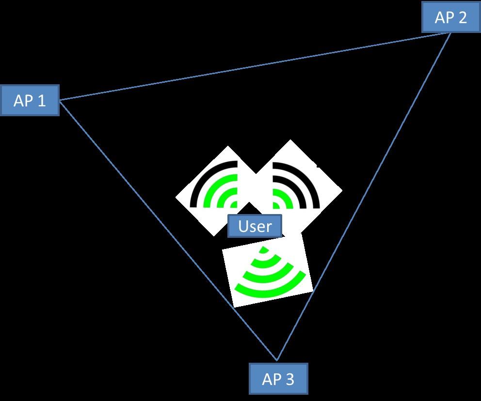
6 Figure 1: Triangulation 6
7 After location is determined, a navigation algorithm may be applied to route a user to a desired destination. This feature may be difficult to implement within the scope of the project but will see completion in the future. FAST Diagram 7
8 Conceptual Design 8
9 Figure 2: Conceptual Design for idocent Implementation 9
10 10
11 Ranking of Conceptual Designs Row Labels Bluetooth Design Wi-Fi Triangulation Dead-Reckoning Design Ultrasonic Receivers Available Tools Deployment Ease of Use Overall Cost Precision Previous Knowledge Grand Total Criteria Rank Legend 1 Best 2 Good 3 OK 4 Not Good 5 Worst 11
12 Proposed Design Solution It was decided that the most feasible solution for indoor navigation could be accomplished using the Android smartphone platform. The particular accessible smartphones available both featured Wi-Fi capabilities and the processing power to deliver accurate results. The smartphone will scan all access points that in range and determine the signal strength in dbm (or dbmw). The strength measurements are translated into a rating from one to twenty, and the access point s MAC address is compared against a database of known access point locations. All of the quantified location coordinates are uploaded to a separate database and averaging is applied to gain a location of the phone. The more available access points, the more accurate the location reading will be. The calculated position will be displayed on a downloaded map on the smartphone from the MSU mobile server. The map coupled with the calculated location will allow the application to give directions to a desired location. Test Plan The first step in testing this design will be to program an Android application to do all of the Wi-Fi scanning and location calculations. This will be done using the Eclipse IDE and the Android SDK libraries. The WifiManager class provides all the functionality to scan and rate WiFi signals. The next requirement will be to acquire at least four Wi-Fi broadcasting devices and to place them in defined locations around an accurately measured room. These locations will need to be added to the program to calculate the position of the phone. Once the hardware and software are in place the calculated location will be monitored to see the accuracy of this system. If more Wi-Fi devices are available, the accuracy of the system can be tested using more or less access points. Ultimately, this approach will be applied to a larger scale implementation, such as the Wi-Fi broadcasting devices already in place in the Engineering Building or MSU Union. This will require mapping the respective building and the wireless routers to GPS coordinates. Once this testing is refined to an acceptable tolerance of plus or minus three feet, the navigation aspect of the application can begin. Once the building and access point GPS coordinates are tolerable, the navigation in and directions to and from a specific location can be determined by making use of Dijkstra s Algorithm. This algorithm will find the shortest path to and from specific points of interest. This can be easily tested by comparing the given path to the path known previously. 12
13 Evaluation Plan The proposed design will be considered successful if it can be demonstrated that this technique can be used to estimate a person s location within several feet inside a room with well defined access point locations. The app should also be able to guide the user around this room to defined points of interest within several feet. 13
14 Risk Analysis The risks assessed are based on the critical path shown in the following project management plan. The plan highlights the fact that the tasks involving Wi-Fi software development, navigation mapping and algorithms, and overall testing all have substantial impacts upon schedule and completion. The analysis of risk was assessed to three key events that pose future challenges and concerns. Potential Pitfalls Task at Risk Description Number Color Cannot obtain the GPS locations of all access points in the designated building (i.e. Engineering Building, The Union) Serious, Likely 12 Yellow Wi-Fi algorithm cannot be refined to specified tolerance (±4 feet) Navigation algorithm and specified paths cannot be determined Major, Low Likelihood 5 Green Serious, Low Likelihood 8 Yellow Risk Analysis Li ke lih o o d Near Certainty Highly Likely Likely Low Likelihood Extremely Improbable Minim al Min or Maj or Serio us Catastrop hic Severity / Impact Risk Value Legend Low < 5 Green Medium > 5 && < 12 Yellow High > 12 Red Table 1: Risk Analysis 14
15 Project Management Plan

16 Figure 3: Gantt Chart with Task List
17 Budget idocent Costs Row Labels Sum of Quantity Sum of Cost Sum of Total Cost idocent Hardware 6 $24.99 $99.96 Smartphone for testing Wireless Routers for testing 4 $24.99 $99.96 idocent Software Smartphone app Website Domain Presentation 2 $34.79 $34.79 Mobile App Presentation Poster 1 $14.79 $14.79 Poster Supplies 1 $20 $20 Grand Total 10 $59.78 $ Financial Analysis Description Amount Available Funds $ Enterprise Costs -$ Extra for Error $ Table 2: Budget
18 Bibliography Carboni, Davide. "Indoor Mobile Pedestrian Navigation System." n.d. CRS4. January 2011 < id=indoornavigation&cache=cache&media=paper_mobile_hci_2010.pdf>. CRS4. Indoor Navigation System Prototype in a modern smartphone (No radio beacon, no GPS, no WiFi). 30 September January 2011 < Patil, Abhishek Pramod. "Performance of Bluetooth Technologies and Their Applications to Location Sensing." January 2011 < Wikipedia. Dead Reckoning. 3 January January 2011 < Work, Eric. "UW Campus Navigator: WiFi Navigation." July Electrical Engineering Department, University of Washington. January 2011 <
MICHIGAN STATE UNIVERSITY. inode for idocent. inode for idocent (indoor Digital Orientation Communication and Enabling Navigational Technology)
") MICHIGAN STATE UNIVERSITY inode for idocent inode for idocent (indoor Digital Orientation Communication and Enabling Navigational Technology) Design Proposal Team Number: 3 Facilitator: Fathi Salem Team
MICHIGAN STATE UNIVERSITY inode for idocent inode for idocent (indoor Digital Orientation Communication and Enabling Navigational Technology) Design Proposal Team Number: 3 Facilitator: Fathi Salem Team
UW Campus Navigator: WiFi Navigation
 UW Campus Navigator: WiFi Navigation Eric Work Electrical Engineering Department University of Washington Introduction When 802.11 wireless networking was first commercialized, the high prices for wireless
Senion IPS 101. An introduction to Indoor Positioning Systems
 Senion IPS 101 An introduction to Indoor Positioning Systems INTRODUCTION Indoor Positioning 101 What is Indoor Positioning Systems? 3 Where IPS is used 4 How does it work? 6 Diverse Radio Environments
Indoor Positioning 101 TECHNICAL)WHITEPAPER) SenionLab)AB) Teknikringen)7) 583)30)Linköping)Sweden)
WHITEPAPER) SenionLab)AB) Teknikringen)7) 583)30)Linköping)Sweden)") Indoor Positioning 101 TECHNICAL)WHITEPAPER) SenionLab)AB) Teknikringen)7) 583)30)Linköping)Sweden) TechnicalWhitepaper)) Satellite-based GPS positioning systems provide users with the position of their
Indoor Positioning 101 TECHNICAL)WHITEPAPER) SenionLab)AB) Teknikringen)7) 583)30)Linköping)Sweden) TechnicalWhitepaper)) Satellite-based GPS positioning systems provide users with the position of their
Context-Aware Planning and Verification
 7 CHAPTER This chapter describes a number of tools and configurations that can be used to enhance the location accuracy of elements (clients, tags, rogue clients, and rogue access points) within an indoor
IoT Wi-Fi- based Indoor Positioning System Using Smartphones
 IoT Wi-Fi- based Indoor Positioning System Using Smartphones Author: Suyash Gupta Abstract The demand for Indoor Location Based Services (LBS) is increasing over the past years as smartphone market expands.
SMART RFID FOR LOCATION TRACKING
 SMART RFID FOR LOCATION TRACKING By: Rashid Rashidzadeh Electrical and Computer Engineering University of Windsor 1 Radio Frequency Identification (RFID) RFID is evolving as a major technology enabler
Introduction to Mobile Sensing Technology
 Introduction to Mobile Sensing Technology Kleomenis Katevas k.katevas@qmul.ac.uk https://minoskt.github.io Image by CRCA / CNRS / University of Toulouse In this talk What is Mobile Sensing? Sensor data,
Real Time Indoor Tracking System using Smartphones and Wi-Fi Technology
 International Journal for Modern Trends in Science and Technology Volume: 03, Issue No: 08, August 2017 ISSN: 2455-3778 http://www.ijmtst.com Real Time Indoor Tracking System using Smartphones and Wi-Fi
Indoor Location System with Wi-Fi and Alternative Cellular Network Signal
 , pp. 59-70 http://dx.doi.org/10.14257/ijmue.2015.10.3.06 Indoor Location System with Wi-Fi and Alternative Cellular Network Signal Md Arafin Mahamud 1 and Mahfuzulhoq Chowdhury 1 1 Dept. of Computer Science
Hardware-free Indoor Navigation for Smartphones
 Hardware-free Indoor Navigation for Smartphones 1 Navigation product line 1996-2015 1996 1998 RTK OTF solution with accuracy 1 cm 8-channel software GPS receiver 2004 2007 Program prototype of Super-sensitive
EIE324 Communication & Telecommunication Lab. Date of the experiment Topics: Objectives : Introduction Equipment Operating Frequencies
 1 EIE324 Communication & Telecommunication Lab. Date of the experiment Topics: WiFi survey 2/61 Chanin wongngamkam Objectives : To study the methods of wireless services measurement To establish the guidelines
Location Planning and Verification
 7 CHAPTER This chapter describes addresses a number of tools and configurations that can be used to enhance location accuracy of elements (clients, tags, rogue clients, and rogue access points) within
MOBILE COMPUTING 1/29/18. Cellular Positioning: Cell ID. Cellular Positioning - Cell ID with TA. CSE 40814/60814 Spring 2018
 MOBILE COMPUTING CSE 40814/60814 Spring 2018 Cellular Positioning: Cell ID Open-source database of cell IDs: opencellid.org Cellular Positioning - Cell ID with TA TA: Timing Advance (time a signal takes
Comparison ibeacon VS Smart Antenna
 Comparison ibeacon VS Smart Antenna Introduction Comparisons between two objects must be exercised within context. For example, no one would compare a car to a couch there is very little in common. Yet,
Remote PED Assistant. Gabriel DeRuwe. Department of Electrical & Computer Engineering
 Remote PED Assistant Gabriel DeRuwe NIATT Department of Electrical & Computer Engineering Smart Signals Research Advanced Pedestrian Assistant What is it: A handheld device for activation of pedestrian
IDOCENT (Indoor Digital Orientation Communication and Enabling Navigation Technology) (Phase 2)
 (Phase 2)") IDOCENT (Indoor Digital Orientation Communication and Enabling Navigation Technology) (Phase 2) December 9 th 2011 Project Facilitator: Dr. John Deller Project Sponsor: Stephen Blosser Team Members Kirk
IDOCENT (Indoor Digital Orientation Communication and Enabling Navigation Technology) (Phase 2) December 9 th 2011 Project Facilitator: Dr. John Deller Project Sponsor: Stephen Blosser Team Members Kirk
Indoor Positioning with a WLAN Access Point List on a Mobile Device
 Indoor Positioning with a WLAN Access Point List on a Mobile Device Marion Hermersdorf, Nokia Research Center Helsinki, Finland Abstract This paper presents indoor positioning results based on the 802.11
The Seamless Localization System for Interworking in Indoor and Outdoor Environments
 W 12 The Seamless Localization System for Interworking in Indoor and Outdoor Environments Dong Myung Lee 1 1. Dept. of Computer Engineering, Tongmyong University; 428, Sinseon-ro, Namgu, Busan 48520, Republic
Herecast: An Open Infrastructure for Location-Based Services using WiFi
 Herecast: An Open Infrastructure for Location-Based Services using WiFi Mark Paciga and Hanan Lutfiyya Presented by Emmanuel Agu CS 525M Introduction User s context includes location, time, date, temperature,
Location Services with Riverbed Xirrus APPLICATION NOTE
 Location Services with Riverbed Xirrus APPLICATION NOTE Introduction Indoor location tracking systems using Wi-Fi, as well as other shorter range wireless technologies, have seen a significant increase
best practice guide Ruckus SPoT Best Practices SOLUTION OVERVIEW AND BEST PRACTICES FOR DEPLOYMENT
 best practice guide Ruckus SPoT Best Practices SOLUTION OVERVIEW AND BEST PRACTICES FOR DEPLOYMENT Overview Since the mobile device industry is alive and well, every corner of the ever-opportunistic tech
Sponsored by. Nisarg Kothari Carnegie Mellon University April 26, 2011
 Sponsored by Nisarg Kothari Carnegie Mellon University April 26, 2011 Motivation Why indoor localization? Navigating malls, airports, office buildings Museum tours, context aware apps Augmented reality
Fingerprinting Based Indoor Positioning System using RSSI Bluetooth
 IJSRD - International Journal for Scientific Research & Development Vol. 1, Issue 4, 2013 ISSN (online): 2321-0613 Fingerprinting Based Indoor Positioning System using RSSI Bluetooth Disha Adalja 1 Girish
IoT. Indoor Positioning with BLE Beacons. Author: Uday Agarwal
 IoT Indoor Positioning with BLE Beacons Author: Uday Agarwal Contents Introduction 1 Bluetooth Low Energy and RSSI 2 Factors Affecting RSSI 3 Distance Calculation 4 Approach to Indoor Positioning 5 Zone
ARUBA LOCATION SERVICES
 ARUBA LOCATION SERVICES Powered by Aruba Beacons The flagship product of the product line is Aruba Beacons. When Aruba Beacons are used in conjunction with the Meridian mobile app platform, they enable
Team Autono-Mo. Jacobia. Department of Computer Science and Engineering The University of Texas at Arlington
 Department of Computer Science and Engineering The University of Texas at Arlington Team Autono-Mo Jacobia Architecture Design Specification Team Members: Bill Butts Darius Salemizadeh Lance Storey Yunesh
Enhanced indoor localization using GPS information
 Enhanced indoor localization using GPS information Taegyung Oh, Yujin Kim, Seung Yeob Nam Dept. of information and Communication Engineering Yeongnam University Gyeong-san, Korea a49094909@ynu.ac.kr, swyj90486@nate.com,
Wi-Fi Fingerprinting through Active Learning using Smartphones
 Wi-Fi Fingerprinting through Active Learning using Smartphones Le T. Nguyen Carnegie Mellon University Moffet Field, CA, USA le.nguyen@sv.cmu.edu Joy Zhang Carnegie Mellon University Moffet Field, CA,
Hack Your Ride With Beacon Technology!
 Hack Your Ride With Beacon Technology! #kontakt_io Trevor Longino Head of Marketing & PR @trevorlongino @kontakt_io We help build the world s best proximity solutions 10 thousand+ clients! Welcome to the
BluEye. Thomas Kelly, EE, Krista Lohr, CSE, Stephen Fialli, EE, and Divya Reddy, CSE
 1 BluEye Thomas Kelly, EE, Krista Lohr, CSE, Stephen Fialli, EE, and Divya Reddy, CSE Abstract BLuEye is a navigation system that will guide the blind and visually impaired in unfamiliar indoor and outdoor
 Wireless Technology Wireless devices transmit information via Electromagnetic waves Early wireless devices Radios often called wireless in old WWII movies Broadcast TV TV remote controls Garage door openers
Exploring Pedestrian Bluetooth and WiFi Detection at Public Transportation Terminals
 Exploring Pedestrian Bluetooth and WiFi Detection at Public Transportation Terminals Neveen Shlayan 1, Abdullah Kurkcu 2, and Kaan Ozbay 3 November 1, 2016 1 Assistant Professor, Department of Electrical
Outdoor Navigation Systems to Promote Urban Mobility to Aid Visually Impaired People
 Journal of Information Systems Engineering & Management, 2018, 3(2), 14 ISSN: 2468-4376 Outdoor Navigation Systems to Promote Urban Mobility to Aid Visually Impaired People André Lima 1, Daniela Mendes
The Deeter Group. Wireless Site Survey Tool
 The Deeter Group Wireless Site Survey Tool Contents Page 1 Introduction... 3 2 Deeter Wireless Sensor System Devices... 4 3 Wireless Site Survey Tool Devices... 4 4 Network Parameters... 4 4.1 LQI... 4
EOS 80D (W) Wireless Function Instruction Manual ENGLISH INSTRUCTION MANUAL
 Wireless Function Instruction Manual ENGLISH INSTRUCTION MANUAL") EOS 80D (W) Wireless Function Instruction Manual ENGLISH INSTRUCTION MANUAL Introduction What You Can Do Using the Wireless Functions This camera s wireless functions let you perform a range of tasks wirelessly,
EOS 80D (W) Wireless Function Instruction Manual ENGLISH INSTRUCTION MANUAL Introduction What You Can Do Using the Wireless Functions This camera s wireless functions let you perform a range of tasks wirelessly,
Paper number ITS-EU-SP0127. Experimenting Bluetooth beacon infrastructure in urban transportation
 11 th ITS European Congress, Glasgow, Scotland, 6-9 June 2016 Paper number ITS-EU-SP0127 Jukka Ahola (jukka.ahola@vtt.fi) 1*, Samuli Heinonen (samuli.heinonen@vtt.fi) 1 1. VTT Technical Research Centre
Indoor Localization and Tracking using Wi-Fi Access Points
 Indoor Localization and Tracking using Wi-Fi Access Points Dubal Omkar #1,Prof. S. S. Koul *2. Department of Information Technology,Smt. Kashibai Navale college of Eng. Pune-41, India. Abstract Location
Cloud Based LightSwitch Edgar Lopez Garcia Professor Kastner CSE 145 Spring 2016
 Cloud Based LightSwitch Edgar Lopez Garcia Professor Kastner CSE 145 Spring 2016 Abstract This paper discusses the research, implementation, and contributions achieved from the Cloud Based LightSwitch
A MOBILE SOLUTION TO HELP VISUALLY IMPAIRED PEOPLE IN PUBLIC TRANSPORTS AND IN PEDESTRIAN WALKS
 D. Brito, et al., Int. J. Sus. Dev. Plann. Vol. 13, No. 2 (2018) 281 293 A MOBILE SOLUTION TO HELP VISUALLY IMPAIRED PEOPLE IN PUBLIC TRANSPORTS AND IN PEDESTRIAN WALKS D. BRITO, T. VIANA, D. SOUSA, A.
Indoor Positioning Using a Modern Smartphone
 Indoor Positioning Using a Modern Smartphone Project Members: Carick Wienke Project Advisor: Dr. Nicholas Kirsch Finish Date: May 2011 May 20, 2011 Contents 1 Problem Description 3 2 Overview of Possible
Together or Alone: Detecting Group Mobility with Wireless Fingerprints
 Together or Alone: Detecting Group Mobility with Wireless Fingerprints Gürkan SOLMAZ and Fang-Jing WU NEC Laboratories Europe, CSST group, Heidelberg, Germany 24 May 2017 This work has received funding
Ubiquitous Positioning: A Pipe Dream or Reality?
 Ubiquitous Positioning: A Pipe Dream or Reality? Professor Terry Moore The University of What is Ubiquitous Positioning? Multi-, low-cost and robust positioning Based on single or multiple users Different
A Study on Investigating Wi-Fi based Fingerprint indoor localization of Trivial Devices
 A Study on Investigating Wi-Fi based Fingerprint indoor localization of Trivial Devices Sangisetti Bhagya Rekha Assistant Professor, Dept. of IT, Vignana Bharathi Institute of Technology, E-mail: bhagyarekha2001@gmail.com
Indoor Positioning System using Magnetic Positioning and BLE beacons
 Indoor Positioning System using Magnetic Positioning and BLE beacons Prof.Manoj.V. Bramhe 1, Jeetendra Gan 2, Nayan Ghodpage 3, Ankit Nawale 4, Gurendra Bahe 5 1Associate Professor & HOD, Dept of Information
Chapter 2 Outdoor Navigation
 Chapter 2 Outdoor Navigation 2.1 Introduction In this chapter, the technologies and techniques that are employed in outdoor navigation systems/services along with their features and users are discussed.
SHOP&NAV: ibeacon based indoor assistance and Navigation System
 International Journal of Scientific and Research Publications, Volume 6, Issue 11, November 2016 71 SHOP&NAV: ibeacon based indoor assistance and Navigation System K.A.D.K.N Peiris,S.A Asmina, A.A.T.K.K
E 322 DESIGN 6 SMART PARKING SYSTEM. Section 1
 E 322 DESIGN 6 SMART PARKING SYSTEM Section 1 Summary of Assignments of Individual Group Members Joany Jores Project overview, GPS Limitations and Solutions Afiq Izzat Mohamad Fuzi SFPark, GPS System Mohd
Indoor Navigation for Visually Impaired / Blind People Using Smart Cane and Mobile Phone: Experimental Work
 Indoor Navigation for Visually Impaired / Blind People Using Smart Cane and Mobile Phone: Experimental Work Ayad Esho Korial * Mohammed Najm Abdullah Department of computer engineering, University of Technology,Baghdad,
Pervasive Indoor Localization and Tracking Based on Fingerprinting. Gary Chan Professor, CSE HKUST
 Pervasive Indoor Localization and Tracking Based on Fingerprinting Gary Chan Professor, CSE HKUST 2 Catchphrase: Location, Location, Location! 3 Outdoor Location-Based Services (LBS) Based on GPS (Global
Enhancing Shipboard Maintenance with Augmented Reality
 Enhancing Shipboard Maintenance with Augmented Reality CACI Oxnard, CA Dennis Giannoni dgiannoni@caci.com (805) 288-6630 INFORMATION DEPLOYED. SOLUTIONS ADVANCED. MISSIONS ACCOMPLISHED. Agenda Virtual
techtip How to Configure Miracast Wireless Display Implementations for Maximum Performance
 How to Configure Miracast Wireless Display Implementations for Maximum Performance Are wireless interference and excessive channel use causing frustration and down time for your wireless users? Do you
INDOOR LOCALIZATION Matias Marenchino
 INDOOR LOCALIZATION Matias Marenchino!! CMSC 818G!! February 27, 2014 BIBLIOGRAPHY RADAR: An In-Building RF-based User Location and Tracking System (Paramvir Bahl and Venkata N. Padmanabhan) WLAN Location
Performance Evaluation of Beacons for Indoor Localization in Smart Buildings
 Performance Evaluation of Beacons for Indoor Localization in Smart Buildings Andrew Mackey, mackeya@uoguelph.ca Petros Spachos, petros@uoguelph.ca University of Guelph, School of Engineering 1 Agenda The
The definitive guide for purchasing Bluetooth Low Energy (BLE) Beacons at scale
 Beacons at scale") The definitive guide for purchasing Bluetooth Low Energy (BLE) Beacons at scale If you re working on an enterprise Request For Quote (RFQ) or Request For Proposal (RFP) for BLE Beacons using any of the
The definitive guide for purchasing Bluetooth Low Energy (BLE) Beacons at scale If you re working on an enterprise Request For Quote (RFQ) or Request For Proposal (RFP) for BLE Beacons using any of the
State of the Location Industry. Presented by Mappedin
 State of the Location Industry Presented by Mappedin 2 State of the Location Industry Table of Contents Introduction 3 Current Market Landscape 4 Determining Best in Show 5 And The Winner is... 6 Appendix
High Precision Urban and Indoor Positioning for Public Safety
 High Precision Urban and Indoor Positioning for Public Safety NextNav LLC September 6, 2012 2012 NextNav LLC Mobile Wireless Location: A Brief Background Mass-market wireless geolocation for wireless devices
Indoor Positioning Systems WLAN Positioning
 Praktikum Mobile und Verteilte Systeme Indoor Positioning Systems WLAN Positioning Prof. Dr. Claudia Linnhoff-Popien Florian Dorfmeister, Chadly Marouane, Kevin Wiesner http://www.mobile.ifi.lmu.de Sommersemester
B L E N e t w o r k A p p l i c a t i o n s f o r S m a r t M o b i l i t y S o l u t i o n s
 B L E N e t w o r k A p p l i c a t i o n s f o r S m a r t M o b i l i t y S o l u t i o n s A t e c h n i c a l r e v i e w i n t h e f r a m e w o r k o f t h e E U s Te t r a m a x P r o g r a m m
On The Feasibility of Using Two Mobile Phones and WLAN Signal to Detect Co-Location of Two Users for Epidemic Prediction
 On The Feasibility of Using Two Mobile Phones and WLAN Signal to Detect Co-Location of Two Users for Epidemic Prediction Khuong An Nguyen, Zhiyuan Luo, Chris Watkins Department of Computer Science, Royal
Collaborative Robotic Navigation Using EZ-Robots
 , October 19-21, 2016, San Francisco, USA Collaborative Robotic Navigation Using EZ-Robots G. Huang, R. Childers, J. Hilton and Y. Sun Abstract - Robots and their applications are becoming more and more
Analysis of Compass Sensor Accuracy on Several Mobile Devices in an Industrial Environment
 Analysis of Compass Sensor Accuracy on Several Mobile Devices in an Industrial Environment Michael Hölzl, Roland Neumeier and Gerald Ostermayer University of Applied Sciences Hagenberg michael.hoelzl@fh-hagenberg.at,
A New Approach to Control a Robot using Android Phone and Colour Detection Technique
 A New Approach to Control a Robot using Android Phone and Colour Detection Technique Saurav Biswas 1 Umaima Rahman 2 Asoke Nath 3 1,2,3 Department of Computer Science, St. Xavier s College, Kolkata-700016,
Technology Challenges and Opportunities in Indoor Location. Doug Rowitch, Qualcomm, San Diego
 PAGE 1 qctconnect.com Technology Challenges and Opportunities in Indoor Location Doug Rowitch, Qualcomm, San Diego 2 nd Invitational Workshop on Opportunistic RF Localization for Future Directions, Technologies,
SCOUT Mobile User Guide 3.0
 SCOUT Mobile User Guide 3.0 Android Guide 3864 - SCOUT February 2017 SCOUT Mobile Table of Contents Supported Devices...1 Multiple Manufacturers...1 The Three Tabs of SCOUT TM Mobile 3.0...1 SCOUT...1
Featherweight GPS Tracker User s Manual June 16, 2017
 Featherweight GPS Tracker User s Manual June 16, 2017 Hardware Configuration and Installation The dimensions for the board are provided below, in inches. Note that with the antenna installed, the total
Applications. HBT02 Transceiver Node. Features. Note: This datasheet is intended for information related to the hardware only.
 Synchrony ighting Control With Wireless Technology HBT01 / HBT02 with HC038V / HCD038 Built-in Detachable Version Applications The freedom of wireless mesh networks configured by smartphone APP s considerably
Implementing Dijkstra s algorithm for vehicle tracking in adverse geographical condition.
 Implementing Dijkstra s algorithm for vehicle tracking in adverse geographical condition. Sayli Aniruddha Patil Juita Tushar Raut Manasi Nitant Vaity Asst. Professor(Dept. of I.T), Asst. Professor(Dept.
Accurate Real-time Indoor Navigation
 Accurate Real-time Indoor Navigation 1 Table of Content 1 Overview... 3 2 Market... 3 3 Indoor Localisation Technologies... 4 3.1 GPS/Assisted GPS... 4 3.2 Wi-Fi Trilateration Low Accuracy... 5 3.3 Hardware
Wireless Local Area Network based Indoor Positioning System: A Study on the Orientation of Wi-Fi Receiving Device towards the Effect on RSSI
 Wireless Local Area Network based Indoor Positioning System: A Study on the Orientation of Wi-Fi Receiving Device towards the Effect on RSSI *1 OOI CHIN SEANG and 2 KOAY FONG THAI *1 Engineering Department,
CSRmesh Beacon management and Asset Tracking Muhammad Ulislam Field Applications Engineer, Staff, Qualcomm Atheros, Inc.
 CSRmesh Beacon management and Asset Tracking Muhammad Ulislam Field Applications Engineer, Staff, Qualcomm Atheros, Inc. CSRmesh Recap Bluetooth Mesh Introduction What is CSRmesh? A protocol that runs
GPS-Based Navigation & Positioning Challenges in Communications- Enabled Driver Assistance Systems
 GPS-Based Navigation & Positioning Challenges in Communications- Enabled Driver Assistance Systems Chaminda Basnayake, Ph.D. Senior Research Engineer General Motors Research & Development and Planning
Using Small Affordable Robots for Hybrid Simulation of Wireless Data Access Systems
 Using Small Affordable Robots for Hybrid Simulation of Wireless Data Access Systems Gorka Guerrero, Roberto Yus, and Eduardo Mena IIS Department, University of Zaragoza María de Luna 1, 50018, Zaragoza,
Networking Devices over White Spaces
 Networking Devices over White Spaces Ranveer Chandra Collaborators: Thomas Moscibroda, Rohan Murty, Victor Bahl Goal: Deploy Wireless Network Base Station (BS) Good throughput for all nodes Avoid interfering
Re: ENSC 440 Project Proposal for an Ultrasonic Local Positioning System
 September 28 th, 2015 Dr. Andrew Rawicz School of Engineering Science Simon Fraser University Burnaby, BC, V5A 1S6 Re: ENSC 440 Project Proposal for an Ultrasonic Local Positioning System Dear Dr. Rawicz,
Ultrasonic Mass Positioning & Wireless Data Collection
 Ultrasonic Mass Positioning & Wireless Data Collection I o w a S t a t e U n i v e r s i t y H o n e y w e l l F M & T K C P A d v i s e r : A l e k s a n d a r D o g a n z i c T e a m M e m b e r s :
Location Based Technologies
 Location Based Technologies I have often wondered whether people really understand Location Based Services (LBS) technology and whether they would like a bit more insight into how exactly location based
ANDROID APPS DEVELOPMENT FOR MOBILE GAME
 ANDROID APPS DEVELOPMENT FOR MOBILE GAME Lecture 5: Sensor and Location Sensor Overview Most Android-powered devices have built-in sensors that measure motion, orientation, and various environmental conditions.
Concept of the application supporting blind and visually impaired people in public transport
 Academia Journal of Educational Research 5(12): 472-476, December 2017 DOI: 10.15413/ajer.2017.0714 ISSN 2315-7704 2017 Academia Publishing Research Paper Concept of the application supporting blind and
Smart Antenna Techniques and Their Application to Wireless Ad Hoc Networks. Plenary Talk at: Jack H. Winters. September 13, 2005
 Smart Antenna Techniques and Their Application to Wireless Ad Hoc Networks Plenary Talk at: Jack H. Winters September 13, 2005 jwinters@motia.com 12/05/03 Slide 1 1 Outline Service Limitations Smart Antennas
Pixie Location of Things Platform Introduction
 Pixie Location of Things Platform Introduction Location of Things LoT Location of Things (LoT) is an Internet of Things (IoT) platform that differentiates itself on the inclusion of accurate location awareness,
Indoor Navigation by WLAN Location Fingerprinting
 Indoor Navigation by WLAN Location Fingerprinting Reducing Trainings-Efforts with Interpolated Radio Maps Dutzler Roland & Ebner Martin Institute for Information Systems and Computer Media Graz University
NavShoe Pedestrian Inertial Navigation Technology Brief
 NavShoe Pedestrian Inertial Navigation Technology Brief Eric Foxlin Aug. 8, 2006 WPI Workshop on Precision Indoor Personnel Location and Tracking for Emergency Responders The Problem GPS doesn t work indoors
Networks of any size and topology. System infrastructure monitoring and control. Bridging for different radio networks
 INTEGRATED SOLUTION FOR MOTOTRBO TM Networks of any size and topology System infrastructure monitoring and control Bridging for different radio networks Integrated Solution for MOTOTRBO TM Networks of
Ultrasound-Based Indoor Robot Localization Using Ambient Temperature Compensation
 Acta Universitatis Sapientiae Electrical and Mechanical Engineering, 8 (2016) 19-28 DOI: 10.1515/auseme-2017-0002 Ultrasound-Based Indoor Robot Localization Using Ambient Temperature Compensation Csaba
Procedures for Testing and Troubleshooting Radianse RTLS
 Procedures for Testing and Troubleshooting Radianse RTLS Christine Vogel Brigham & Women s Hospital Clinical Engineering Intern University of Connecticut M.S. Biomedical Engineering Student Spring 2013
Enhanced wireless indoor tracking system in multi-floor buildings with location prediction
 Enhanced wireless indoor tracking system in multi-floor buildings with location prediction Rui Zhou University of Freiburg, Germany June 29, 2006 Conference, Tartu, Estonia Content Location based services
User navigation and location tracking system indoor localization for smartphones Using Wi-Fi
 User navigation and location tracking system indoor localization for smartphones Using Wi-Fi Prof. Ratnaraj Kumar 1, Sanap Swati B. 2, Raut Pradnya P. 3, Pathan Abbas Y. 4 1,2,3,4 Department Of Computer
Chanalyzer 4. Chanalyzer 4 by MetaGeek USER GUIDE page 1
 Chanalyzer 4 Chanalyzer 4 by MetaGeek USER GUIDE page 1 Chanalyzer 4 spectrum analysis software Table of Contents Introduction What is a Wi-Spy? What is Chanalyzer? Installation Choose a Wireless Network
BeFitter Apps Manual
 BeFitter Apps Manual Key features The apps BF Hiker, BF Cycle, BF XC Ski and BF Runner have 13 pages. You can toggle through these pages with the previous page and next page function. See the chapter User
Sandia National Laboratories Clinic Team
 Sandia National Laboratories Clinic Team Matt Strum (Zach Smart, Jake Scheid, Jacob Fawson, and Ali Aldarwish) Advisor Behrouz Farhang Final Project Proposal May 4, 2011 Contents Functional Description...
LOCALIZATION AND ROUTING AGAINST JAMMERS IN WIRELESS NETWORKS
 Available Online at www.ijcsmc.com International Journal of Computer Science and Mobile Computing A Monthly Journal of Computer Science and Information Technology IJCSMC, Vol. 4, Issue. 5, May 2015, pg.955
Passive Sensors Technical Guide
 Application Note Version 1.0 10/17/2016 This document is a technical user guide to the working principles and usage of Smartrac passive sensor products using RF Micron Magnus S2 and S3 ICs. 1. INTRODUCTION...
Virtual Guide Dog: the Next Generation Pedestrian Signal for the Visually Impaired
 Virtual Guide Dog: the Next Generation Pedestrian Signal for the Visually Impaired Joyoung Lee Assistant Professor Co-Authors: Zijia Zhong, Branislav Dimitrjevic, and Kitae Kim ITS Resource Center New
RF Management in SonicOS 4.0 Enhanced
 RF Management in SonicOS 4.0 Enhanced Document Scope This document describes how to plan, design, implement, and maintain the RF Management feature in SonicWALL SonicOS 4.0 Enhanced. This document contains
Master Thesis Presentation Future Electric Vehicle on Lego By Karan Savant. Guide: Dr. Kai Huang
 Master Thesis Presentation Future Electric Vehicle on Lego By Karan Savant Guide: Dr. Kai Huang Overview Objective Lego Car Wifi Interface to Lego Car Lego Car FPGA System Android Application Conclusion
Indoor Positioning and Navigation System Market Research Report- Forecast 2023
 Report Information More information from: https://www.marketresearchfuture.com/reports/1775 Indoor Positioning and Navigation System Market Research Report- Forecast 2023 Report / Search Code: MRFR/SEM/1243-CRR
Specification. Patent Pending. Description : AccuraUWB Flex Series 3~10GHz Ultra-Wide Band (UWB) Flex Antenna with 100mm 1.
 Flex Antenna with 100mm 1.") Specification Patent Pending Part No. : FXUWB10.07.0100C Description : AccuraUWB Flex Series 3~10GHz Ultra-Wide Band (UWB) Flex Antenna with 100mm 1.37mm IPEX MHFHT Features : Flexible UWB Antenna Mounting
Specification Patent Pending Part No. : FXUWB10.07.0100C Description : AccuraUWB Flex Series 3~10GHz Ultra-Wide Band (UWB) Flex Antenna with 100mm 1.37mm IPEX MHFHT Features : Flexible UWB Antenna Mounting
E90 Project Proposal. 6 December 2006 Paul Azunre Thomas Murray David Wright
 E90 Project Proposal 6 December 2006 Paul Azunre Thomas Murray David Wright Table of Contents Abstract 3 Introduction..4 Technical Discussion...4 Tracking Input..4 Haptic Feedack.6 Project Implementation....7
V2X-Locate Positioning System Whitepaper
 V2X-Locate Positioning System Whitepaper November 8, 2017 www.cohdawireless.com 1 Introduction The most important piece of information any autonomous system must know is its position in the world. This