Presented by: Mark Landress WB5ANN
|
|
|
- Randolph Taylor
- 5 years ago
- Views:
Transcription

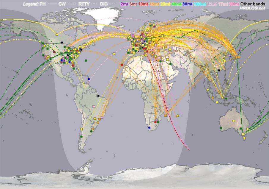
1 Presented by: Mark Landress WB5ANN Distribution of Licensed Amateur Radio Operators in the US 2016 Courtesy ARRL Ham Radio Mapping - WB5ANN 1
2 Outline Basics Latitude and Longitude Map Types and Projections Maidenhead Grid System Prefix Maps Contest Maps Propagation Maps Repeaters, IRLP, Viewshed, Modelling & Satellite and Coverage Conclusion Ham Radio Mapping - WB5ANN 2
3 Basics Ham mapping involves some basic principles for locating transmitted and received points. Knowing the map types, systems and grids, helps in obtaining a fix and computing distance to a point. Computerized mapping has dramatically improved the ability to locate stations. Manual mapping is still handy since it is quick and is always ready. Ham Radio Mapping - WB5ANN 3


4 History 3 rd Century BC Erathosnes (inventor of Geography, keeper of the library in Alexandria. First to determine the circumference of the earth. First to calculate tilt of earth axis, all around smart guy. First to devise longitude and latitude as a concept. 2 nd Century BC Hipparcus (inventor of spherical geometry and first to set places in a spherical projection. Discoverer of equinox precession, calculation of solar eclipses, first to determine heliocentric placement of solar system, calculate distances to sun and moon. Determined method that local time can be used to calculate position of longitude. Once the compass was discovered in the 11 th century, maps started to come into use. Latitude easy to determine since it relates to axis position. Longitude requires accurate time to determine position for navigation. Done originally by lunar and solar measurements. Better defined by Decartes (cartography) Finally solved when accurate clocks were devised. This was finally solved by John Harrison in Ham Radio Mapping - WB5ANN 4

5 Longitude and Latitude The Earth is divided into vertical lines of Longitude and horizontal lines of Latitude. Zero longitude is at the Prime Meridian in England. West longitude is negative, East longitude is positive. Zero latitude is at the equator. North latitude is positive. South latitude is negative. Each is measured in degrees, minutes and seconds or decimal degrees. 360 degrees for the whole. 60 minutes per degree. 60 seconds per minute. Each minute of longitude equals 1 nautical mile (6028 feet) Ham Radio Mapping - WB5ANN 5

6 Longitude and Latitude Ham Radio Mapping - WB5ANN 6

7 Mercator Projection The Mercator projection is still one of the most common types of map. On this type of map the direction remains true, making it particularly practical for navigation at sea. Most maps projected to flat surfaces are Mercator projection. The problem is it is hard to measure distance with a Mercator map. Ham Radio Mapping - WB5ANN 7

8 Distance Problem with Mercator Point to point measurement is distorted in a Mercator map. This is solved with projections that accurately portray the great circle. Ham Radio Mapping - WB5ANN 8


9 Other Grid Systems Universal Transverse Mercator - XY type metric grid widely used for mapping by USACOE MGRS Military grid system based on Lat/Lon with letter/number grid designation State Plane Coordinate System XY type English grid system specific for each state PLSS - Township & Range Mile square sections within a 36 square mile block. Ham Radio Mapping - WB5ANN 9
10 Maidenhead Grid Maidenhead grids or Grid Squares is the standard designation for map location in ham radio. Named for the city Maidenhead England it was developed in 1980 and divides the earth into grids based upon latitude and longitude. Zones are separated into 18 fields 10 by 20 degrees designated with 2 letters A through R Grids are designated by 1 by 2 degrees with 2 numbers 0-9 Subgrids are designated by 2 letters 2.5 x 5 minutes with letters A-X Ham Radio Mapping - WB5ANN 10

11 Maidenhead Grid System (1) Mercator Projection Maidenhead Grid Square Field Designation 10 degrees of latitude by 20 degrees of longitude Houston, TX = EL Ham Radio Mapping - WB5ANN 11

12 Maidenhead Grid System (1) Global Projection for North America W120 N40 W100 W80 W60 N30 N20 Ham Radio Mapping - WB5ANN 12

13 What grid is this? Ham Radio Mapping - WB5ANN 13

14 Maidenhead Grid System (2) EL Grid is 10 x 20 degrees. EL29 is 1 x 2 degrees N30 W100 First Digit 1200 statute miles W80 EL N20 20 Deg 1300 statute miles Ham Radio Mapping - WB5ANN 14

15 Maidenhead Grid Sub Square 5 minutes of longitude by 2.5 minutes of latitude First Letter Subsquare gu Second Letter Subsquare EL29 Ham Radio Mapping - WB5ANN 15

16 Ham Location Mapping by Grid Location mapping from QRZ.com EL29fv EL29gv EL29fu EL29gu EL29ft EL29gt Ham Radio Mapping - WB5ANN 16

17 Ham Location Mapping by Grid Ham Radio Mapping - WB5ANN 17
18 Prefix Maps Ham Radio Mapping - WB5ANN 18

19 US Call Sign Prefix Map Ham Radio Mapping - WB5ANN 19

20 World Prefix Map Mercator Projection Ham Radio Mapping - WB5ANN 20

21 Great Circle Prefix Map Great circle maps are equidistant from all points km 621 mi Diamater 28,000 km Ham Radio Mapping - WB5ANN 21
22 Contest Mapping Ham Radio Mapping - WB5ANN 22

23 ITU Zone Map ITU is the international body that mediates the radio spectrum ITU zones are used for contests and award hunting Ham Radio Mapping - WB5ANN 23

24 CQ Zone Map CQ Magazine Contest Zones CQ zones are used for contests and award hunting Ham Radio Mapping - WB5ANN 24

25 DX Century Club Map DXCC is the top award in Amateur Radio via ARRL 100 confirmed contacts to DXCC entities needed for award Ham Radio Mapping - WB5ANN 25


26 Contact Mapping DXmaps.com Ham Radio Mapping - WB5ANN 26

27 Automatic Spot Mapping Ham Radio Mapping - WB5ANN 27

28 Weak Signal Propagation WSPR Net Ham Radio Mapping - WB5ANN 28

29 Reverse Beacon Ham Radio Mapping - WB5ANN 29
30 Propagation Mapping Ham Radio Mapping - WB5ANN 30


31 Charged Particle Layers Charged particle layers, solar activity and cosmic effects control propagation. Maps of the effects of space weather, aurora and other features are made more or less real time and are useful for predicting band openings. Ham Radio Mapping - WB5ANN 31


32 Space Weather Maps Space weather prediction primarily involves watching solar flares, solar wind, sunspots and aurora activity. All affect the charged particle layers around the earth and affect both terrestrial communications and satellites. This also impacts the magnetic field. Ham Radio Mapping - WB5ANN 32

33 MUF Maps (HF) Maximum Useable Frequency Map is the frequency where long range signals will propagate. Real-time MUF is available online from space weather sites Real time MUF for May 27, MUF typically tracks the sun position which is affected by sunspots and charged particles. Ham Radio Mapping - WB5ANN 33

34 Total Electron Count These maps are also used to monitor ionospheric weather, and to nowcast ionospheric storms that often occur responding to activities in solar wind and Earth's magnetosphere as well as thermosphere. The electron count affects the MUF along with proton flux. Note TEC map tends to mirror MUF. Ham Radio Mapping - WB5ANN 34
 144 mhz")

35 Propagation Maps (VHF) 144 mhz Propagation from APRS Ham Radio Mapping - WB5ANN 35


36 Ham Radio Mapping - WB5ANN 36

37 Magnetic Field Map The magnetic field, generated in the core and measured at the surface, continues upward through the ionosphere, the electrically-conducting, ionized layer of the Earth's upper atmosphere. The ionosphere extends in height from about 90 km to about 600 km, and it is electrically conducting because ultraviolet radiation from the Sun is absorbed by the electrons of nitrogen and oxygen molecules in the atmosphere. This absorption causes electrons to be dislodged from their molecular orbits, thereby producing free negative charges (electrons) and free positive charges (ions). As the Earth rotates underneath the Sun, periodic differential heating of the atmosphere causes it to expand on the day-side and contract on the night-side. Superimposed upon this variation is an atmospheric tide, similar to the oceanic tide and driven most substantially by the rotation of the Earth under the gravitational field of the Moon. The combination of these periodic forces drive winds in the ionosphere, and with the resulting fluid motion across magneticfield lines, electric currents are induced. These currents support their own magnetic fields, and thus a diurnal perturbation in the magnetic field is generated. The diurnal-field variation can be measured at the Earth's surface, and with an array of magnetometers it is possible to map the electric currents in the ionosphere. Ionospheric Electric Currents. Schematic diagram of the electric-current pattern in the ionosphere driven by diurnal heating from the Sun. Note that the current is concentrated on the day side, consisting of two oppositely oriented circuits. Ham Radio Mapping - WB5ANN 37


38 Auroral Map (N Polar) Estimated shape and character of the northern polar auroral oval, as derived from measurements of energy deposition into the auroral oval by the NOAA/TIROS spacecraft The color bar at the right denotes the estimated power flux input into the auroral zone, in ergs*cm^-2*sec^-1. The yellow arrow points in the direction of the noon sector, where sunlight would prevent observations of auroral activity. Auroral propagation is typically important at high latitudes Ham Radio Mapping - WB5ANN 38

39 Ionogram Maps The height of the ionosphere plotted against frequency. Ham Radio Mapping - WB5ANN 39
40 Internet Radio Linking and Repeater Maps Signal Coverage Ham Radio Mapping - WB5ANN 40


41 IRLP Mapping IRLP maps show the locations of internet linked repeaters and their connections across the world. Mapping of real time IRLP nodes projected with great circle connections using Google Earth. Links. Pop-up link points to active, inactive and idle nodes. Ham Radio Mapping - WB5ANN 41

42 Repeater Maps Online repeater mapping from K5EHX with 30 mile range rings. There are a large amount of online maps now that give real time status and location of active repeaters in the US. Ham Radio Mapping - WB5ANN 42


43 APRS Mapping APRS or Automated Packet Reporting System works with a GPS, a small TNC and a radio running on mhz. The position is reported to the system with "raw packets" (left) which is translated to position, direction and speed. Other information including weather also is transmitted. Ham Radio Mapping - WB5ANN 43


44 Signal Coverage Maps HF model coverage for rhombic antenna. VHF model power distribution for a hand-held radio taking into account terrain. A digital topo map is used and line of sight prediction software calculates the range and power. Ham Radio Mapping - WB5ANN 44

45 Whats Hot Ham Radio Mapping - WB5ANN 45


46 Viewshed Analysis Viewshed shows the visible line of sight path from a location. Slightly different than signal coverage New feature in Google Earth. Ham Radio Mapping - WB5ANN 46

47 Viewshed Analysis Mobile operating on US59 East of Downtown before Convention Center Ham Radio Mapping - WB5ANN 47


48 Modeling Maps VHF EM Effect in Vehicle Simulated SAR Exposure Cell Phone Exposure Ham Radio Mapping - WB5ANN 48

49 Satellite Coverage and Prediction Ham Radio Mapping - WB5ANN 49

50 Summary A Map is a diagrammatic representation of features in 2 dimensions. Ham Radio Mapping - WB5ANN 50

51 Ham Radio Mapping - WB5ANN 51
Chapter 6 Propagation
 Chapter 6 Propagation Al Penney VO1NO Objectives To become familiar with: Classification of waves wrt propagation; Factors that affect radio wave propagation; and Propagation characteristics of Amateur
Space Weather and Propagation JANUARY 14, 2017
 Space Weather and Propagation MARTIN BUEHRING -KB4MG ELEC T R ICAL ENGINEER, A M AT EUR EXTRA CLASS LICENSE HOLDER JANUARY 14, 2017 Why know about Space Weather? Our SUN has an enormous affect not only
Chapter 7 HF Propagation. Ionosphere Solar Effects Scatter and NVIS
 Chapter 7 HF Propagation Ionosphere Solar Effects Scatter and NVIS Ionosphere and Layers Radio Waves Bent by the Ionosphere Daily variation of Ionosphere Layers Ionospheric Reflection Conduction by electrons
4/29/2012. General Class Element 3 Course Presentation. Radio Wave Propagation. Radio Wave Propagation. Radio Wave Propagation.
 General Class Element 3 Course Presentation ti ELEMENT 3 SUB ELEMENTS General Licensing Class Subelement G3 3 Exam Questions, 3 Groups G1 Commission s Rules G2 Operating Procedures G3 G4 Amateur Radio
Terry G. Glagowski W1TR / AFA1DI
 The Ionogram and Radio Propagation By Terry G. Glagowski / W1TR / AFA1DI - 9/29/2017 9:46 AM Excerpts from a presentation by Tom Carrigan / NE1R / AFA1ID by Terry G. Glagowski W1TR / AFA1DI Knowledge of
ESS 7 Lectures 15 and 16 November 3 and 5, The Atmosphere and Ionosphere
 ESS 7 Lectures 15 and 16 November 3 and 5, 2008 The Atmosphere and Ionosphere The Earth s Atmosphere The Earth s upper atmosphere is important for groundbased and satellite radio communication and navigation.
General Classs Chapter 7
 General Classs Chapter 7 Radio Wave Propagation Bob KA9BHD Eric K9VIC Learning Objectives Teach you enough to get all the propagation questions right during the VE Session Learn a few things from you about
Space Weather and the Ionosphere
 Dynamic Positioning Conference October 17-18, 2000 Sensors Space Weather and the Ionosphere Grant Marshall Trimble Navigation, Inc. Note: Use the Page Down key to view this presentation correctly Space
The Earth s Atmosphere
 ESS 7 Lectures 15 and 16 May 5 and 7, 2010 The Atmosphere and Ionosphere The Earth s Atmosphere The Earth s upper atmosphere is important for groundbased and satellite radio communication and navigation.
VHF/UHF Beyond FM Bob Witte KØNR Page 1
 VHF/UHF Beyond FM Technical Coordinator Colorado Section Page 1 Objective The objective of this presentation is to provide an introduction to operating on VHF/UHF, going beyond the usual FM / Repeater
Lesson 12: Signal Propagation
 Lesson 12: Signal Propagation Preparation for Amateur Radio Technician Class Exam Topics HF Propagation Ground-wave Sky-wave Ionospheric regions VHF/UHF Propagation Line-of-sight Tropospheric Bending and
Sw earth Dw Direct wave GRw Ground reflected wave Sw Surface wave
 WAVE PROPAGATION By Marcel H. De Canck, ON5AU Electromagnetic radio waves can propagate in three different ways between the transmitter and the receiver. 1- Ground waves 2- Troposphere waves 3- Sky waves
Propagation Tool.
 Propagation Propagation Tool http://www.hamqsl.com/solar.html The Ionosphere is made up of several layers at varying heights above the ground: The lowest level is the D Layer (37 to 56 miles), which
High Frequency Propagation (and a little about NVIS)
") High Frequency Propagation (and a little about NVIS) Tom McDermott, N5EG August 18, 2010 September 2, 2010 Updated: February 7, 2013 The problem Radio waves, like light waves, travel in ~straight lines.
High Frequency Propagation (and a little about NVIS) Tom McDermott, N5EG August 18, 2010 September 2, 2010 Updated: February 7, 2013 The problem Radio waves, like light waves, travel in ~straight lines.
OBJECTIVES: PROPAGATION INTRO RADIO WAVES POLARIZATION LINE OF SIGHT, GROUND WAVE, SKY WAVE IONOSPHERE REGIONS PROPAGATION, HOPS, SKIPS ZONES THE
 WAVE PROPAGATION OBJECTIVES: PROPAGATION INTRO RADIO WAVES POLARIZATION LINE OF SIGHT, GROUND WAVE, SKY WAVE IONOSPHERE REGIONS PROPAGATION, HOPS, SKIPS ZONES THE IONOSPHERIC LAYERS ABSORPTION AND FADING
1. Terrestrial propagation
 Rec. ITU-R P.844-1 1 RECOMMENDATION ITU-R P.844-1 * IONOSPHERIC FACTORS AFFECTING FREQUENCY SHARING IN THE VHF AND UHF BANDS (30 MHz-3 GHz) (Question ITU-R 218/3) (1992-1994) Rec. ITU-R PI.844-1 The ITU
NVIS PROPAGATION THEORY AND PRACTICE
 NVIS PROPAGATION THEORY AND PRACTICE Introduction Near-Vertical Incident Skywave (NVIS) propagation is a mode of HF operation that utilizes a high angle reflection off the ionosphere to fill in the gap
Ionospheric Propagation
 Ionospheric Nick Massey VA7NRM 1 Electromagnetic Spectrum Radio Waves are a form of Electromagnetic Radiation Visible Light is also a form of Electromagnetic Radiation Radio Waves behave a lot like light
Amateur Radio License. Propagation and Antennas
 Amateur Radio License Propagation and Antennas Todays Topics Propagation Antennas Propagation Modes Ground wave Low HF and below, ground acts as waveguide Line-of-Sight (LOS) VHF and above, radio waves
Topics in Propagation
 Topics in Propagation Extra Class Course Spring 2013 Andy Durbin k3wyc Propagation The magic that allows a signal to travel between the transmitting antenna and the receiving antenna. This course is limited
Storms in Earth s ionosphere
 Storms in Earth s ionosphere Archana Bhattacharyya Indian Institute of Geomagnetism IISF 2017, WSE Conclave; Anna University, Chennai Earth s Ionosphere Ionosphere is the region of the atmosphere in which
RF Propagation. By Tim Kuhlman, PE KD7RUS
 RF Propagation By Tim Kuhlman, PE KD7RUS Purpose of this Seminar In this seminar we will attempt to answer the following questions: What is RF propagation? What are the different types of propagation?
RF Propagation. By Tim Kuhlman, PE KD7RUS
 RF Propagation By Tim Kuhlman, PE KD7RUS Purpose of this Seminar In this seminar we will attempt to answer the following questions: What is RF propagation? What are the different types of propagation?
Maximum Usable Frequency
 Maximum Usable Frequency 15 Frequency (MHz) 10 5 0 Maximum Usable Frequency Usable Frequency Window Lowest Usable Frequency Solar Flare 6 12 18 24 Time (Hours) Radio Blackout Usable Frequency Window Ken
Study of small scale plasma irregularities. Đorđe Stevanović
 Study of small scale plasma irregularities in the ionosphere Đorđe Stevanović Overview 1. Global Navigation Satellite Systems 2. Space weather 3. Ionosphere and its effects 4. Case study a. Instruments
VHF Propagation Overview 5-Oct-2016
 VHF Propagation Overview 5-Oct-2016 G0RVM 1 VHF Propagation Where in the radio spectrum is VHF? 30MHz to 300MHz for radio amateurs its 50MHz, 70MHz & 144MHz or 6m, 4m & 2m Name some types of VHF propagation?
3 Methods of radiocommunication
 + + & & * * ) ) From the ITU Emergency Telecommunications handbook; prepared for the 54 th JOTA 2011. 3 Methods of radiocommunication 3.1 Frequencies Radio frequencies should be selected according to propagation
Global Maps with Contoured Ionosphere Properties Some F-Layer Anomalies Revealed By Marcel H. De Canck, ON5AU. E Layer Critical Frequencies Maps
 Global Maps with Contoured Ionosphere Properties Some F-Layer Anomalies Revealed By Marcel H. De Canck, ON5AU In this column, I shall handle some possibilities given by PROPLAB-PRO to have information
Polarization orientation of the electric field vector with respect to the earth s surface (ground).
.") Free space propagation of electromagnetic waves is often called radio-frequency (rf) propagation or simply radio propagation. The earth s atmosphere, as medium introduces losses and impairments to the
Free space propagation of electromagnetic waves is often called radio-frequency (rf) propagation or simply radio propagation. The earth s atmosphere, as medium introduces losses and impairments to the
Plasma in the ionosphere Ionization and Recombination
 Plasma in the ionosphere Ionization and Recombination Jamil Muhammad Supervisor: Professor kjell Rönnmark 1 Contents: 1. Introduction 3 1.1 History.3 1.2 What is the ionosphere?...4 2. Ionization and recombination.5
Monitoring the polar cap/ auroral ionosphere: Industrial applications. P. T. Jayachandran Physics Department University of New Brunswick Fredericton
 Monitoring the polar cap/ auroral ionosphere: Industrial applications P. T. Jayachandran Physics Department University of New Brunswick Fredericton Outline Ionosphere and its effects on modern and old
The Ionosphere and Thermosphere: a Geospace Perspective
 The Ionosphere and Thermosphere: a Geospace Perspective John Foster, MIT Haystack Observatory CEDAR Student Workshop June 24, 2018 North America Introduction My Geospace Background (Who is the Lecturer?
Reading 28 PROPAGATION THE IONOSPHERE
 Reading 28 Ron Bertrand VK2DQ http://www.radioelectronicschool.com PROPAGATION THE IONOSPHERE The ionosphere is a region of the upper atmosphere extending from a height of about 60 km to greater than 500
4/18/2012. Supplement T3. 3 Exam Questions, 3 Groups. Amateur Radio Technician Class
 Amateur Radio Technician Class Element 2 Course Presentation ti ELEMENT 2 SUB-ELEMENTS Technician Licensing Class Supplement T3 Radio Wave Characteristics 3 Exam Questions, 3 Groups T1 - FCC Rules, descriptions
The Effect of Geomagnetic Storm in the Ionosphere using N-h Profiles.
 The Effect of Geomagnetic Storm in the Ionosphere using N-h Profiles. J.C. Morka * ; D.N. Nwachuku; and D.A. Ogwu. Physics Department, College of Education, Agbor, Nigeria E-mail: johnmorka84@gmail.com
FCC Technician License Course
 FCC Technician License Course 2014-2018 FCC Element 2 Technician Class Question Pool Presented by: Tamiami Amateur Radio Club (TARC) WELCOME To the third of 4, 3-hour classes presented by TARC to prepare
Using the Radio Spectrum to Understand Space Weather
 Using the Radio Spectrum to Understand Space Weather Ray Greenwald Virginia Tech Topics to be Covered What is Space Weather? Origins and impacts Analogies with terrestrial weather Monitoring Space Weather
Antennas and Propagation Chapters T4, G7, G8 Antenna Fundamentals, More Antenna Types, Feed lines and Measurements, Propagation
 Antennas and Propagation Chapters T4, G7, G8 Antenna Fundamentals, More Antenna Types, Feed lines and Measurements, Propagation =============================================================== Antenna Fundamentals
Class Overview. Antenna Fundamentals Repeaters Duplex and Simplex Nets and Frequencies Cool Radio Functions Review
 Class Overview Antenna Fundamentals Repeaters Duplex and Simplex Nets and Frequencies Cool Radio Functions Review Antennas Antennas An antenna is a device used for converting electrical currents into electromagnetic
Scientific Studies of the High-Latitude Ionosphere with the Ionosphere Dynamics and ElectroDynamics - Data Assimilation (IDED-DA) Model
 Model") DISTRIBUTION STATEMENT A. Approved for public release; distribution is unlimited. Scientific Studies of the High-Latitude Ionosphere with the Ionosphere Dynamics and ElectroDynamics - Data Assimilation
DISTRIBUTION STATEMENT A. Approved for public release; distribution is unlimited. Scientific Studies of the High-Latitude Ionosphere with the Ionosphere Dynamics and ElectroDynamics - Data Assimilation
ROTI Maps: a new IGS s ionospheric product characterizing the ionospheric irregularities occurrence
 3-7 July 2017 ROTI Maps: a new IGS s ionospheric product characterizing the ionospheric irregularities occurrence Iurii Cherniak Andrzej Krankowski Irina Zakharenkova Space Radio-Diagnostic Research Center,
Dartmouth College SuperDARN Radars
 Dartmouth College SuperDARN Radars Under the guidance of Thayer School professor Simon Shepherd, a pair of backscatter radars were constructed in the desert of central Oregon over the Summer and Fall of
Introduction to HF Propagation. Rick Fletcher, W7YP FVARC November 20, 2018
 Introduction to HF Propagation Rick Fletcher, W7YP FVARC November 20, 2018 Topics The HF Bands How HF propagation works Overview by HF band Sources of solar and propagation information Working HF during
CHAPTER 6. Propagation
 CHAPTER 6 Propagation TOC: INTRO RADIO WAVES POLARIZATION LINE OF SIGHT, GROUND & SKY WAVES IONOSPHERE REGIONS IONOSPHERIC LAYERS PROPAGATION, HOPS, SKIPS ZONES ABSORPTION AND FADING SOLAR ACTIVITY AND
Propagation Software Review rev 1
 Propagation Software Review rev 1 Carl Luetzelschwab K9LA k9la@arrl.net :KDW:H UH*RLQJWR&RYHU The model of the ionosphere :KDW VFRPPRQDPRQJDOOWKHVRIWZDUH Getting started with propagation predictions :KDW
The Role of Ground-Based Observations in M-I I Coupling Research. John Foster MIT Haystack Observatory
 The Role of Ground-Based Observations in M-I I Coupling Research John Foster MIT Haystack Observatory CEDAR/GEM Student Workshop Outline Some Definitions: Magnetosphere, etc. Space Weather Ionospheric
Sub-Mesoscale Imaging of the Ionosphere with SMAP
 Sub-Mesoscale Imaging of the Ionosphere with SMAP Tony Freeman Xiaoqing Pi Xiaoyan Zhou CEOS Workshop, ASF, Fairbanks, Alaska, December 2009 1 Soil Moisture Active-Passive (SMAP) Overview Baseline Mission
Radiation and Particles from the. Sun
 2017 Radiation and Particles from the Photons Sun Photons (300000km/s ~ 8m 20s) radio waves, infra red, visible light, ultra violet, x-ray, x galactic waves, Solar Flux (30000km/s ~ 8m 20s) The 10.7 cm
Chapter 15: Radio-Wave Propagation
 Chapter 15: Radio-Wave Propagation MULTIPLE CHOICE 1. Radio waves were first predicted mathematically by: a. Armstrong c. Maxwell b. Hertz d. Marconi 2. Radio waves were first demonstrated experimentally
IONOSPHERE EFFECTS ON GPS/RF COMMUNICATION, ELECTRIC, METAL NETWORKS AND SPACECRAFTS OSMAN AKGÜN
 IONOSPHERE EFFECTS ON GPS/RF COMMUNICATION, ELECTRIC, METAL NETWORKS AND SPACECRAFTS 2119212 OSMAN AKGÜN IONOSPHERE IONOSPHERE EFFECTS POSSIBLE EFFECTS GPS errors Atomic oxygen attack Spacecraft charging
Ionospheric Propagation
 Ionospheric Propagation Page 1 Ionospheric Propagation The ionosphere exists between about 90 and 1000 km above the earth s surface. Radiation from the sun ionizes atoms and molecules here, liberating
Introduction To The Ionosphere
 Introduction To The Ionosphere John Bosco Habarulema Radar School 12 13 September 2015, SANSA, What is a radar? This being a radar school... RAdio Detection And Ranging To determine the range, R, R=Ct/2,
PoS(2nd MCCT -SKADS)003
003") The Earth's ionosphere: structure and composition. Dispersive effects, absorption and emission in EM wave propagation 1 Observatorio Astronómico Nacional Calle Alfonso XII, 3; E-28014 Madrid, Spain E-mail:
The Earth's ionosphere: structure and composition. Dispersive effects, absorption and emission in EM wave propagation 1 Observatorio Astronómico Nacional Calle Alfonso XII, 3; E-28014 Madrid, Spain E-mail:
CRITICAL FREQUENCY By Marcel H. De Canck, ON5AU
 CRITICAL FREQUENCY By Marcel H. De Canck, ON5AU Before reading onward, it would be good to refresh your knowledge about refraction rules in the section on Refraction of the earlier "Wave Propagation Direction
Propagation Modelling White Paper
 Propagation Modelling White Paper Propagation Modelling White Paper Abstract: One of the key determinants of a radio link s received signal strength, whether wanted or interfering, is how the radio waves
Technician Licensing Class
 Technician Licensing Class Talk to Outer Presented Space by Amateur Radio Technician Class Element 2 Course Presentation ELEMENT 2 SUB-ELEMENTS (Groupings) About Ham Radio Call Signs Control Mind the Rules
Technician License Course Chapter 4
 Technician License Course Chapter 4 Propagation, Basic Antennas, Feed lines & SWR K0NK 26 Jan 18 The Antenna System Antenna: Facilitates the sending of your signal to some distant station. Feed line: Connects
RADIO WAVE PROPAGATION
 CHAPTER 2 RADIO WAVE PROPAGATION Radio direction finding (RDF) deals with the direction of arrival of radio waves. Therefore, it is necessary to understand the basic principles involved in the propagation
CHAPTER 1 INTRODUCTION
 CHAPTER 1 INTRODUCTION The dependence of society to technology increased in recent years as the technology has enhanced. increased. Moreover, in addition to technology, the dependence of society to nature
Chapter 1: Telecommunication Fundamentals
 Chapter 1: Telecommunication Fundamentals Block Diagram of a communication system Noise n(t) m(t) Information (base-band signal) Signal Processing Carrier Circuits s(t) Transmission Medium r(t) Signal
RECOMMENDATION ITU-R P Guide to the application of the propagation methods of Radiocommunication Study Group 3
 Rec. ITU-R P.1144-2 1 RECOMMENDATION ITU-R P.1144-2 Guide to the application of the propagation methods of Radiocommunication Study Group 3 (1995-1999-2001) The ITU Radiocommunication Assembly, considering
The USU-GAIM Data Assimilation Models for Ionospheric Specifications and Forecasts
 The USU-GAIM Data Assimilation Models for Ionospheric Specifications and Forecasts L. Scherliess, R. W. Schunk, L. C. Gardner, L. Zhu, J.V. Eccles and J.J Sojka Center for Atmospheric and Space Sciences
Personal Space Weather Station
 Personal Space Weather Station Nathaniel A. Frissell, W2NAF 1 1 New Jersey Institute of Technology, K2MFF Introduction Space Weather is a common interest of hams, scientists, and engineers. By studying
DYNAMIC POSITIONING CONFERENCE October 17 18, 2000 SENSORS. Space Weather and the Ionosphere. Grant Marshall Trimble Navigation Inc.
 DYNAMIC POSIIONING CONFERENCE October 17 18, 2000 SENSORS Space Weather and the Ionosphere Grant Marshall rimble Navigation Inc. Images shown here are part of an animated presentation and may not appear
Propagation During Solar Cycle 24. Frank Donovan W3LPL
 Propagation During Solar Cycle 24 Frank Donovan W3LPL Introduction This presentation focuses on: The four major fall and winter DX contests: CQ WW SSB and CW ARRL DX SSB and CW The years of highest solar
RECOMMENDATION ITU-R P Prediction of sky-wave field strength at frequencies between about 150 and khz
 Rec. ITU-R P.1147-2 1 RECOMMENDATION ITU-R P.1147-2 Prediction of sky-wave field strength at frequencies between about 150 and 1 700 khz (Question ITU-R 225/3) (1995-1999-2003) The ITU Radiocommunication
GPS for Snowmobilers. By Wayne Fischer. November 14, 2006
 GPS for Snowmobilers By Wayne Fischer November 14, 2006 Wayne@TahoeSnowmobiling.org Copy of White Paper & Presentation Both this presentation and the white paper are available on the www.tahoesnowmobiling.org
UNIT V PROPAGATION The three basic types of propagation: Sky Wave Propagation: Space Wave Propagation: Ground Wave Propagation: Propagation of Waves
 UNIT V PROPAGATION The three basic types of propagation: Ground wave, space wave and sky wave propagation. Sky Wave Propagation: Structure of the ionosphere Effective dielectric constant of ionized region
Eclipse Radio Science at NASA Marshall Space Flight Center
 Eclipse Radio Science at NASA Marshall Space Flight Center Ghee Fry, WL7C Jesse McTernan, KN4EZR Linda Rawlins NASA Marshall Space Flight Center, Huntsville, AL NJIT, Newark NJ 1 The MSFC Eclipse Radio
RECOMMENDATION ITU-R P HF PROPAGATION PREDICTION METHOD* (Question ITU-R 223/3)
") Rec. ITU-R P.533-6 1 RECOMMENDATION ITU-R P.533-6 HF PROPAGATION PREDICTION METHOD* (Question ITU-R 223/3) Rec. ITU-R P.533-6 (1978-1982-1990-1992-1994-1995-1999) The ITU Radiocommunication Assembly, considering
Rec. ITU-R P.533-6 1 RECOMMENDATION ITU-R P.533-6 HF PROPAGATION PREDICTION METHOD* (Question ITU-R 223/3) Rec. ITU-R P.533-6 (1978-1982-1990-1992-1994-1995-1999) The ITU Radiocommunication Assembly, considering
Amateur Radio Satellites
 Amateur Radio Satellites An Introduction and Demo of AO-85 Eddie Pettis, N5JGK and Russ Tillman, K5NRK Presentation Outline History of Amateur Radio Satellites: Project OSCAR and AMSAT Amateur Radio Satellites
COVENANT UNIVERSITY NIGERIA TUTORIAL KIT OMEGA SEMESTER PROGRAMME: PHYSICS
 COVENANT UNIVERSITY NIGERIA TUTORIAL KIT OMEGA SEMESTER PROGRAMME: PHYSICS COURSE: PHY 423 DISCLAIMER The contents of this document are intended for practice and leaning purposes at the undergraduate level.
HF Skywave ITU-R P Gets a Re-Write. July Pierre Missud Avadh Nandra. RF Modeling with Precision
 HF Skywave ITU-R P.533-9 Gets a Re-Write July 2008 Pierre Missud Avadh Nandra RF Modeling with Precision 0 0 HF Skywave ITU-R P. 533-9 gets a re-write HF skywave propagation was introduced to this world
Land Navigation / Map Reading
 Land Navigation / Map Reading What is the Field Manual for map reading and land navigation? FM 3-25.26 What are the basic colors of a map, and what does each color represent? Black - Indicates cultural
GLOBAL POSITIONING SYSTEMS. Knowing where and when
 GLOBAL POSITIONING SYSTEMS Knowing where and when Overview Continuous position fixes Worldwide coverage Latitude/Longitude/Height Centimeter accuracy Accurate time Feasibility studies begun in 1960 s.
AN INTRODUCTION TO VHF/ UHF PROPAGATION. Paul Wilton, M1CNK
 AN INTRODUCTION TO VHF/ UHF PROPAGATION Paul Wilton, M1CNK OVERVIEW Introduction Propagation Basics Propagation Modes Getting Started in 2m DX INTRODUCTION QRV on 2m SSB since Aug 1998, on 6m since Jan
Yavapai Amateur Radio Club 4 September 2008
 Yavapai Amateur Radio Club http://www.w7yrc.org/ 4 September 2008 Having Fun with the Amateur Satellites by Patrick Stoddard http://www.wd9ewk.net/ Amateur satellite history, in brief OSCAR I launched
James M Anderson. in collaboration with Jan Noordam and Oleg Smirnov. MPIfR, Bonn, 2006 Dec 07
 Ionospheric Calibration for Long-Baseline, Low-Frequency Interferometry in collaboration with Jan Noordam and Oleg Smirnov Page 1/36 Outline The challenge for radioastronomy Introduction to the ionosphere
On the Importance of Radio Occultation data for Ionosphere Modeling
 On the Importance of Radio Occultation data for Ionosphere Modeling IROWG Workshop, Estes Park, March 30, 2012 ABSTRACT The availability of unprecedented amounts of Global Navigation Satellite Systems
Current Solar Cycle Poor propagation No propagation Checking HF propagation. Coping with poor HF propagation Q&A
 Topics Current Solar Cycle Poor propagation No propagation Checking HF propagation Predictive (HF propagation prediction software) Empirical (beacons, WSPR, PSKREPORTER and operator testing) Coping with
Plasma in the Ionosphere Ionization and Recombination
 Plasma in the Ionosphere Ionization and Recombination Agabi E Oshiorenoya July, 2004 Space Physics 5P Umeå Universitet Department of Physics Umeå, Sweden Contents 1 Introduction 6 2 Ionization and Recombination
right during the VE Session Have fun Bob, KA9BH Eric, K9VIC
 Radio Wave Propagation Teach you enough to get all right during the VE Session Learn a few things from you Have fun Finish everything on time (if the propagation questions about your experiences not a
Technical and operational characteristics of land mobile MF/HF systems
 Recommendation ITU-R M.1795 (03/2007) Technical and operational characteristics of land mobile MF/HF systems M Series Mobile, radiodetermination, amateur and related satellite services ii Rec. ITU-R M.1795
VI. Signal Propagation Effects. Image courtesy of
 VI. Signal Propagation Effects Image courtesy of www.tpub.com 56 VI. Signal Propagation Effects Name Date Class At Home Assignment Tune to the most remote AM station you can find. You should attempt to
Chapter 13: Wave Propagation. EET-223: RF Communication Circuits Walter Lara
 Chapter 13: Wave Propagation EET-223: RF Communication Circuits Walter Lara Electrical to Electromagnetic Conversion Since the atmosphere is not a conductor of electrons (instead a good insulator), electrical
Lecture # 7 Coordinate systems and georeferencing
 Lecture # 7 Coordinate systems and georeferencing Coordinate Systems Coordinate reference on a plane Coordinate reference on a sphere Coordinate reference on a plane Coordinates are a convenient way of
Chapter 3 Solution to Problems
 Chapter 3 Solution to Problems 1. The telemetry system of a geostationary communications satellite samples 100 sensors on the spacecraft in sequence. Each sample is transmitted to earth as an eight-bit
What is Space Weather? THE ACTIVE SUN
 Aardvark Roost AOC Space Weather in Southern Africa Hannes Coetzee 1 What is Space Weather? THE ACTIVE SUN 2 The Violant Sun 3 What is Space Weather? Solar eruptive events (solar flares, coronal Mass Space
The Ionosphere and its Impact on Communications and Navigation. Tim Fuller-Rowell NOAA Space Environment Center and CIRES, University of Colorado
 The Ionosphere and its Impact on Communications and Navigation Tim Fuller-Rowell NOAA Space Environment Center and CIRES, University of Colorado Customers for Ionospheric Information High Frequency (HF)
DX University: Antennas
 DX University: Antennas 29 August 31 Kai Siwiak, KE4PT Prepared for N4II s s DX-University series Sponsored by the South Florida DX Association No Antenna Theory, Just Results What does it take to work
A Bistatic HF Radar for Current Mapping and Robust Ship Tracking
 A Bistatic HF Radar for Current Mapping and Robust Ship Tracking Dennis Trizna Imaging Science Research, Inc. V. 703-801-1417 dennis @ isr-sensing.com www.isr-sensing.com Objective: Develop methods for
A Study of the Effects of Sunrise and Sunset on the Ionosphere as Observed by VLF Wave Behavior
 A Study of the Effects of Sunrise and Sunset on the Ionosphere as Observed by VLF Wave Behavior By Leandra Merola South Side High School Rockville Centre, New York Abstract The purpose of this study was
Measurement of VLF propagation perturbations during the January 4, 2011 Partial Solar Eclipse
 Measurement of VLF propagation perturbations during the January 4, 2011 Partial Solar Eclipse by Lionel Loudet 1 January 2011 Contents Abstract...1 Introduction...1 Background...2 VLF Signal Propagation...2
RECOMMENDATION ITU-R P HF propagation prediction method *
 Rec. ITU-R P.533-7 1 RECOMMENDATION ITU-R P.533-7 HF propagation prediction method * (Question ITU-R 3/3) (1978-198-1990-199-1994-1995-1999-001) The ITU Radiocommunication Assembly, considering a) that
t =1 Transmitter #2 Figure 1-1 One Way Ranging Schematic
 1.0 Introduction OpenSource GPS is open source software that runs a GPS receiver based on the Zarlink GP2015 / GP2021 front end and digital processing chipset. It is a fully functional GPS receiver which
Radio Astronomy for Amateurs. Presented by Keith Payea AG6CI
 Radio Astronomy for Amateurs Presented by Keith Payea AG6CI Outline Radio Astronomy Basics: What, How, Why How Amateurs can participate and contribute What is Radio Astronomy? The Study of the non-visible
Analysis of Ionospheric Anomalies due to Space Weather Conditions by using GPS-TEC Variations
 Presented at the FIG Congress 2018, May 6-11, 2018 in Istanbul, Turkey Analysis of Ionospheric Anomalies due to Space Weather Conditions by using GPS-TEC Variations Asst. Prof. Dr. Mustafa ULUKAVAK 1,
SPACE WEATHER SIGNATURES ON VLF RADIO WAVES RECORDED IN BELGRADE
 Publ. Astron. Obs. Belgrade No. 80 (2006), 191-195 Contributed paper SPACE WEATHER SIGNATURES ON VLF RADIO WAVES RECORDED IN BELGRADE DESANKA ŠULIĆ1, VLADIMIR ČADEŽ2, DAVORKA GRUBOR 3 and VIDA ŽIGMAN4
New Synergistic Opportunities for Magnetosphere-Ionosphere-Thermosphere Coupling Investigations Using Swarm and CASSIOPE e-pop
 New Synergistic Opportunities for Magnetosphere-Ionosphere-Thermosphere Coupling Investigations Using Swarm and CASSIOPE e-pop Andrew W. Yau 1, R. Floberghagen 2, Leroy L. Cogger 1, Eelco N. Doornbos 3,
[titlelscientific Studies of the High-Latitude Ionosphere with the Ionosphere Dynamics and Electrodynamics-Data Assimilation (IDED-DA) Model
 Model") [titlelscientific Studies of the High-Latitude Ionosphere with the Ionosphere Dynamics and Electrodynamics-Data Assimilation (IDED-DA) Model [awardnumberl]n00014-13-l-0267 [awardnumber2] [awardnumbermore]
[titlelscientific Studies of the High-Latitude Ionosphere with the Ionosphere Dynamics and Electrodynamics-Data Assimilation (IDED-DA) Model [awardnumberl]n00014-13-l-0267 [awardnumber2] [awardnumbermore]