Preliminary results of ionosphere measurement from GNOS on China FY-3C satellite
|
|
|
- Adrian Harris
- 5 years ago
- Views:
Transcription


1 Preliminary results of ionosphere measurement from GNOS on China FY-3C satellite Guanglin Yang 1, Tian Mao 1, Lingfeng Sun 2, Xinan Yue 3, Weihua Bai 4 and Yueqiang Sun 4 1 National Satellite Meteorological Center, China, yglyang@cma.gov.cn 2 Institute of Geology and Geophysics, Chinese Academy of Sciences, China 3 COSMIC Program Office, University Corporation for Atmospheric Research, USA 4 Center for Space Science and Applied Research, China
2 Outline Introduction to FY-3C & GNOS GNOS ionospheric measurement results Summary and outlook 2

3 Introduction to FY-3C FY (FengYun): Chinese meteorological satellite FY-3: second generation polar-orbiting satellite FY-3C: 3rd flight unit of the FY-3 series ; First satellite of the FY3 02 batches Operational satellite Orbit Sun-synchronous orbit Altitude 836 km ECT 10:15 desc Launch End of life 2018 Status Operational 3

4 Introduction to GNOS ON FY-3C GNSS occultation sounder GNOS Measures the phase delay due to refraction during occultation between GNSS satellites and FY-3C GNOS receives signals from GPS and BDS Parameter Constellation Channel number Sampling rate Designed Precision of F2 peak electron density Content GPS:L1 L2 BDS:B1 B2 Positioning: 8 Occultation: GPS 6 BDS 4 Ionosphere occultation: 1Hz 20% 4
5 Productions about ionosphere L1 Ionosphere excess phase (IE) nc format L2 Electron density profile (EDP) nc format 5
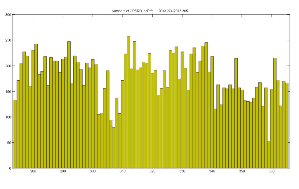
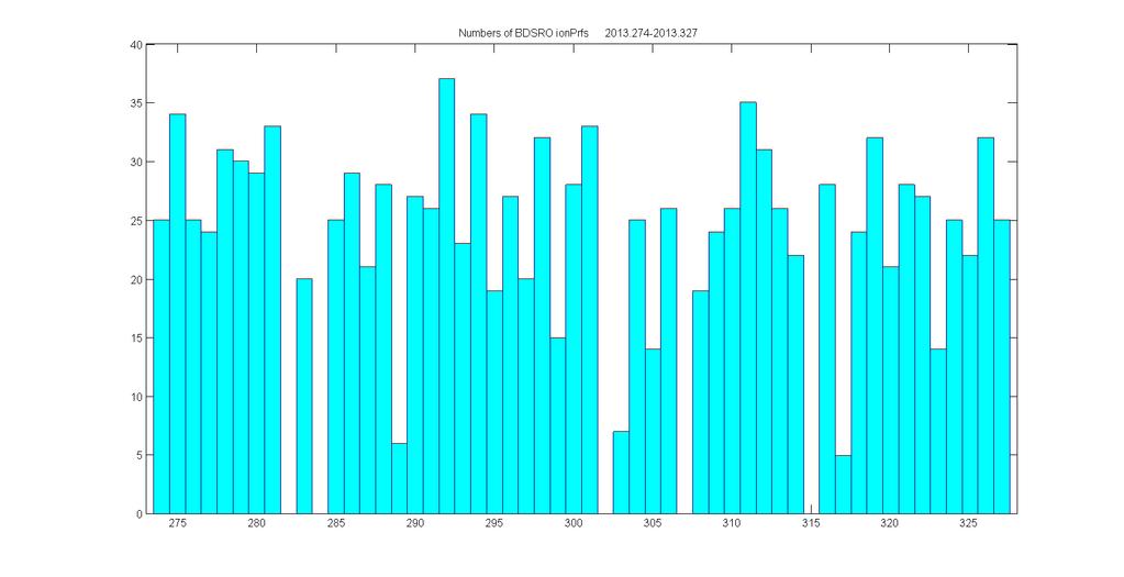
6 Present status 6
7 7
8 8
9 9
10 Evaluation1: comparison with ionosonde Data GNOS EDPs GPSRO: BDSRO: Ionosonde observation data Source: GIRO(Global Ionospheric Radio Observatory) 54 sites Compared Parameters NmF2 (fof2 NmF2) hmf2 10
11 Evaluation1 : comparison with ionosonde Data quality control GNOS EDPs quality control Incomplete profiles were wiped off Profiles that NmF2<0 were wiped off Ionosonde data quality control Record that have both hmf2 and NmF2 simultaneously w as kept; Space weather condition screening Kp < 4 Time-space matching Time interval < 0.5 hrs Spherical distance < 200 kms 11
12 Evaluation1: GPSRO NmF2 ensemble Good agreement between the GNOS GPSRO and the ionosonde measurement 12
13 Evaluation1: GPSRO NmF2 Re.std. : rising > setting 13
14 Evaluation1: GPSRO NmF2 Lt:~10am Lt:~10pm Re.std. : daytime < nighttime 14
15 Evaluation1: GPSRO NmF2-30<lat<30 30 lat lat -30 Lat 60 lat ,1,2(north) 6,7,8(south) 3-5,9-11 (north&south) 6,7,8(north) 12,1,2 (south) 15
16 Evaluation1: GPSRO hmf2 ensemble Also agreement 16
17 Evaluation1: GPSRO hmf2 Std. : rising < setting 17
18 Evaluation1: GPSRO hmf2 Std. : daytime < nighttime 18
19 Evaluation1: GPSRO hmf2 19
20 Evaluation1: BDSRO NmF2 ensemble NmF2 Re.Std.: BDSRO > GPSRO, but slightly 20
21 Evaluation1: BDSRO hmf2 ensemble hmf2 Std.: BDSRO < GPSRO, but slightly the precision of EDP production of BDSRO is equivalent to that of GPSRO 21
22 GPSRO-IONO NmF2 Dataset Corr.Coef. Re.bias Re.Std. Number ensemble % 16.80% 423 Rising % 18.74% 172 Setting % 15.32% 251 Daytime % 16.19% 254 nighttime % 17.60% 169 winter % 18.30% 108 Spring & autumn % 17.89% 209 Summer % 11.82% 106 Low latitude % 19.07% 60 Middle latitude % 15.83% 270 High latitude % 18.05% 93 GPSRO-IONO hmf2 Dataset Corr.Coef. Bias Std. Number ensemble km km 423 Rising km km 172 Setting km km 251 Daytime km km 254 nighttime km km 169 winter km km 108 Spring & autumn km km 209 Summer km km 106 Low latitude km km 60 Middle latitude km km 270 High latitude km km 93 22
23 Summary on evaluation 1 FY-3C GNOS comparison with ionosonde For GPS RO: Corr. Coef. For NmF2 >0.9 Corr. Coef. For hmf2 >0.7 NmF2 Re.Std. <20% hmf2 Std. <30km For BDS RO: NmF2 Corr. Coef.=0.96 hmf2 Corr. Coef.=0.8 NmF2 Re.Std. =20.58% hmf2 Std. =25 km The results show good agreement between the GNOS and the ionosonde measurement, and the precision of EDP production of BDSRO is equivalent to that of GPSRO 23
 and IRI model results (bottom panel) in the Northern Hemisphere. The black line describes the location of the magnetic equator.")
24 Evaluation2: comparison with IRI This figure gives the NmF2 maps as functions of geographic latitude and longitude from GNOS measurements (top panel) and IRI model results (bottom panel) in the Northern Hemisphere. The black line describes the location of the magnetic equator. 24

25 hmf2 maps of GNOS measurements and IRI results 25

26 Observed example: particle precipitation induced ionization enhancement 26
27 Summary In addition to GPS, GNOS is capable of tracking the B DS signals from the LEO for the first time. Preliminary comparisons show good agreement betw een the GNOS and the ionosonde measurement, and the precision of EDP production of BDSRO is equival ent to that of GPSRO. The comparison between the FY3C/GNOS data and t he IRI model is also reasonably good, but the IRI mod el tends to overestimate NmF2 at the crests of the eq uatorial anomalies. GNOS EDPs show ionization enhancement around E layer during nighttime due to the energetic particle pre cipitation over the Aurora and SAA regions. 27
28 Outlook More satellites to carry the GNOS onboard FY3D FY3E FY3F FY3G FY3H More RO channels to observe ionosphere RO eve nts GPS RO channels: 6 8 BDS RO channels : 4 8 More BDS satellites to track the signals About 40 BeiDou navigation satellites in total by 2020 Global coverage Promote the quantity and quality of GNOS RO data 28

29 GNOS data start from June 1 st,
30 THANK YOU 30
Application of Fengyun 3-C GNSS occulation sounder for assessing global ionospheric response to magnetic storm event
 Atmos. Meas. Tech. Discuss., doi:0./amt-0-, 0 Published: 0 October 0 c Author(s) 0. CC-BY.0 License. Application of Fengyun -C GNSS occulation sounder for assessing global ionospheric response to magnetic
THE story of radio occultation (RO) began at the dawn
 began at the dawn") IEEE TRANSACTIONS ON GEOSCIENCE AND REMOTE SENSING 1 First Ionospheric Radio-Occultation Measurements From GNSS Occultation Sounder on the Chinese Feng-Yun 3C Satellite Tian Mao, Lingfeng Sun, Guanglin
IEEE TRANSACTIONS ON GEOSCIENCE AND REMOTE SENSING 1 First Ionospheric Radio-Occultation Measurements From GNSS Occultation Sounder on the Chinese Feng-Yun 3C Satellite Tian Mao, Lingfeng Sun, Guanglin
Data assimilation of FORMOSAT-3/COSMIC using NCAR Thermosphere Ionosphere Electrodynamic General Circulation Model (TIE-GCM)
") Session 2B-03 5 th FORMOSAT-3 / COSMIC Data Users Workshop & ICGPSRO 2011 Data assimilation of FORMOSAT-3/COSMIC using NCAR Thermosphere Ionosphere Electrodynamic General Circulation Model (TIE-GCM) I
Session 2B-03 5 th FORMOSAT-3 / COSMIC Data Users Workshop & ICGPSRO 2011 Data assimilation of FORMOSAT-3/COSMIC using NCAR Thermosphere Ionosphere Electrodynamic General Circulation Model (TIE-GCM) I
Topside Ionospheric Model Based On the Electron Density Profile Data of Cosmic Mission
 Topside Ionospheric Model Based On the Electron Density Profile Data of Cosmic Mission PING Jingsong, SHI Xian, GUO Peng, YAN Haojian Shanghai Astronomical Observatory, Chinese Academy of Sciences, Nandan
CMA future prospects for radio occultation
 CMA future prospects for radio occultation Peng Zhang NSMC/CMA Presented to CGMS-[43] [Plenary & Working Group II] session, agenda item [5] GNOS--Global 1. FY3C/GNOS overview lobal Navigation Satellite
COSMIC / FormoSat 3 Overview, Status, First results, Data distribution
 COSMIC / FormoSat 3 Overview, Status, First results, Data distribution COSMIC Introduction / Status Early results from COSMIC Neutral Atmosphere profiles Refractivity Temperature, Water vapor Planetary
Outline. GPS RO Overview. COSMIC Overview. COSMIC-2 Overview. Summary 9/29/16
 Bill Schreiner and UCAR/COSMIC Team UCAR COSMIC Program Observation and Analysis Opportunities Collaborating with the ICON and GOLD Missions Sept 27, 216 GPS RO Overview Outline COSMIC Overview COSMIC-2
Space Weather and the Ionosphere
 Dynamic Positioning Conference October 17-18, 2000 Sensors Space Weather and the Ionosphere Grant Marshall Trimble Navigation, Inc. Note: Use the Page Down key to view this presentation correctly Space
OPAC-1 International Workshop Graz, Austria, September 16 20, Advancement of GNSS Radio Occultation Retrieval in the Upper Stratosphere
 OPAC-1 International Workshop Graz, Austria, September 16 0, 00 00 by IGAM/UG Email: andreas.gobiet@uni-graz.at Advancement of GNSS Radio Occultation Retrieval in the Upper Stratosphere A. Gobiet and G.
Ionospheric Monitoring in China. Zhen Weimin, Ou Ming
 ICG-5 WG-B, Turino Ionospheric Monitoring in China Zhen Weimin, Ou Ming October 20 th, 2010, Turino, Italy Outline 1.Introduction 2.Ionosphere monitoring in China 3.Summary 1. Introduction GNSS performance
Artificial plasma cave in the low latitude ionosphere results from the radio occultation inversion of the FORMOSAT 3/ COSMIC
 Click Here for Full Article JOURNAL OF GEOPHYSICAL RESEARCH, VOL. 115,, doi:10.1029/2009ja015079, 2010 Artificial plasma cave in the low latitude ionosphere results from the radio occultation inversion
Present and future IGS Ionospheric products
 Present and future IGS Ionospheric products Andrzej Krankowski, Manuel Hernández-Pajares, Joachim Feltens, Attila Komjathy, Stefan Schaer, Alberto García-Rigo, Pawel Wielgosz Outline Introduction IGS IONO
What is Space Weather? THE ACTIVE SUN
 Aardvark Roost AOC Space Weather in Southern Africa Hannes Coetzee 1 What is Space Weather? THE ACTIVE SUN 2 The Violant Sun 3 What is Space Weather? Solar eruptive events (solar flares, coronal Mass Space
SPIDR on the Web: Space Physics Interactive
 Radio Science, Volume 32, Number 5, Pages 2021-2026, September-October 1997 SPIDR on the Web: Space Physics Interactive Data Resource on-line analysis tool Karen Fay O'Loughlin Cooperative Institute for
Three-dimensional and numerical ray tracing on a phenomenological ionospheric model
 Three-dimensional and numerical ray tracing on a phenomenological ionospheric model Lung-Chih Tsai 1, 2, C. H. Liu 3, T. Y. Hsiao 4, and J. Y. Huang 1 (1) Center for Space and Remote Sensing research,
Ionospheric Radio Occultation Measurements Onboard CHAMP
 Ionospheric Radio Occultation Measurements Onboard CHAMP N. Jakowski 1, K. Tsybulya 1, S. M. Stankov 1, V. Wilken 1, S. Heise 2, A. Wehrenpfennig 3 1 DLR / Institut für Kommunikation und Navigation, Kalkhorstweg
Prepared by IROWG 18 September 2013 IROWG/DOC/2013/01
 CRITICAL IMPACT OF THE POTENTIAL DELAY OR DESCOPING OF THE COSMIC-2/FORMOSAT-7 PROGRAMME Assessment by the IROWG, September 2013 1. Introduction The 41 st session of the Coordination Group for Meteorological
Ionosphere Observability Using GNSS and LEO Platforms. Brian Breitsch Advisor: Dr. Jade Morton
 Ionosphere Observability Using GNSS and LEO Platforms Brian Breitsch Advisor: Dr. Jade Morton 1 Motivate ionosphere TEC observations Past work in ionosphere observability Observation volume Ground receivers
Observations of Ionosphere/Troposphere Coupling as Observed by COSMIC
 Observations of Ionosphere/Troposphere Coupling as Observed by COSMIC K. F. Dymond, C. Coker, D. E. Siskind, A. C. Nicholas, S. A. Budzien, S. E. McDonald, and C. E. Dymond * Space Science Division, Naval
Improvement and validation of retrieved FORMOSAT-3/COSMIC electron densities using Jicamarca DPS
 Improvement and validation of retrieved FORMOSAT-3/COSMIC electron densities using Jicamarca DPS, Y.-A. Liou, C.-C. Lee, M. Hernández-Pajares, J.M. Juan, J. Sanz, B.W. Reinisch Outline 1. RO: Classical
Activities of the JPL Ionosphere Group
 Activities of the JPL Ionosphere Group On-going GIM wor Submit rapid and final GIM TEC maps for IGS combined ionosphere products FAA WAAS & SBAS analysis Error bounds for Brazilian sector, increasing availability
Radio tomography based on satellite beacon experiment and FORMOSAT- 3/COSMIC radio occultation
 Radio tomography based on satellite beacon experiment and FORMOSAT- 3/COSMIC radio occultation Mamoru Yamamoto (1), Smitha V. Thampi (2), Charles Lin (3) (1) RISH, Kyoto University, Japan (2) Space Physics
Space geodetic techniques for remote sensing the ionosphere
 Space geodetic techniques for remote sensing the ionosphere Harald Schuh 1,2, Mahdi Alizadeh 1, Jens Wickert 2, Christina Arras 2 1. Institute of Geodesy and Geoinformation Science, Technische Universität
Study of small scale plasma irregularities. Đorđe Stevanović
 Study of small scale plasma irregularities in the ionosphere Đorđe Stevanović Overview 1. Global Navigation Satellite Systems 2. Space weather 3. Ionosphere and its effects 4. Case study a. Instruments
imaging of the ionosphere and its applications to radio propagation Fundamentals of tomographic Ionospheric Tomography I: Ionospheric Tomography I:
 Ionospheric Tomography I: Ionospheric Tomography I: Fundamentals of tomographic imaging of the ionosphere and its applications to radio propagation Summary Introduction to tomography Introduction to tomography
Developing systems for ionospheric data assimilation
 Developing systems for ionospheric data assimilation Making a quantitative comparison between observations and models A.C. Bushell, 5 th European Space Weather Week, Brussels, 20 th November 2008 Collaborators
Use of GNSS Radio Occultation data for Climate Applications Bill Schreiner Sergey Sokolovskiy, Doug Hunt, Ben Ho, Bill Kuo UCAR
 Use of GNSS Radio Occultation data for Climate Applications Bill Schreiner (schrein@ucar.edu), Sergey Sokolovskiy, Doug Hunt, Ben Ho, Bill Kuo UCAR COSMIC Program Office www.cosmic.ucar.edu 1 Questions
Comparing the Low-- and Mid Latitude Ionosphere and Electrodynamics of TIE-GCM and the Coupled GIP TIE-GCM
 Comparing the Low-- and Mid Latitude Ionosphere and Electrodynamics of TIE-GCM and the Coupled GIP TIE-GCM Clarah Lelei Bryn Mawr College Mentors: Dr. Astrid Maute, Dr. Art Richmond and Dr. George Millward
Monitoring the Ionosphere and Neutral Atmosphere with GPS
 Monitoring the Ionosphere and Neutral Atmosphere with GPS Richard B. Langley Geodetic Research Laboratory Department of Geodesy and Geomatics Engineering University of New Brunswick Fredericton, N.B. Division
ROTI Maps: a new IGS s ionospheric product characterizing the ionospheric irregularities occurrence
 3-7 July 2017 ROTI Maps: a new IGS s ionospheric product characterizing the ionospheric irregularities occurrence Iurii Cherniak Andrzej Krankowski Irina Zakharenkova Space Radio-Diagnostic Research Center,
The Effect of Geomagnetic Storm in the Ionosphere using N-h Profiles.
 The Effect of Geomagnetic Storm in the Ionosphere using N-h Profiles. J.C. Morka * ; D.N. Nwachuku; and D.A. Ogwu. Physics Department, College of Education, Agbor, Nigeria E-mail: johnmorka84@gmail.com
A study of the ionospheric effect on GBAS (Ground-Based Augmentation System) using the nation-wide GPS network data in Japan
 using the nation-wide GPS network data in Japan") A study of the ionospheric effect on GBAS (Ground-Based Augmentation System) using the nation-wide GPS network data in Japan Takayuki Yoshihara, Electronic Navigation Research Institute (ENRI) Naoki Fujii,
A study of the ionospheric effect on GBAS (Ground-Based Augmentation System) using the nation-wide GPS network data in Japan Takayuki Yoshihara, Electronic Navigation Research Institute (ENRI) Naoki Fujii,
Regional ionospheric disturbances during magnetic storms. John Foster
 Regional ionospheric disturbances during magnetic storms John Foster Regional Ionospheric Disturbances John Foster MIT Haystack Observatory Regional Disturbances Meso-Scale (1000s km) Storm Enhanced Density
An overview of the COSMIC follow-on mission (COSMIC-II) and its potential for GNSS-R
 and its potential for GNSS-R") An overview of the COSMIC follow-on mission (COSMIC-II) and its potential for GNSS-R Lidia Cucurull (1), Dave Ector (2), and Estel Cardellach (3) (1) NOAA/NWS/NCEP/EMC (2) NOAA/NESDIS/OSD (3) IEEC/ICE-CSIC
An overview of the COSMIC follow-on mission (COSMIC-II) and its potential for GNSS-R Lidia Cucurull (1), Dave Ector (2), and Estel Cardellach (3) (1) NOAA/NWS/NCEP/EMC (2) NOAA/NESDIS/OSD (3) IEEC/ICE-CSIC
First assimilations of COSMIC radio occultation data into the Electron Density Assimilative Model (EDAM)
") Ann. Geophys., 26, 353 359, 2008 European Geosciences Union 2008 Annales Geophysicae First assimilations of COSMIC radio occultation data into the Electron Density Assimilative Model (EDAM) M. J. Angling
Ann. Geophys., 26, 353 359, 2008 European Geosciences Union 2008 Annales Geophysicae First assimilations of COSMIC radio occultation data into the Electron Density Assimilative Model (EDAM) M. J. Angling
Radio Science. Real-time ionospheric N(h) profile updating over Europe using IRI-2000 model
 profile updating over Europe using IRI-2000 model") Advances in Radio Science (2004) 2: 299 303 Copernicus GmbH 2004 Advances in Radio Science Real-time ionospheric N(h) profile updating over Europe using IRI-2000 model D. Buresova 1, Lj. R. Cander 2, A.
Advances in Radio Science (2004) 2: 299 303 Copernicus GmbH 2004 Advances in Radio Science Real-time ionospheric N(h) profile updating over Europe using IRI-2000 model D. Buresova 1, Lj. R. Cander 2, A.
Satellite Navigation Science and Technology for Africa. 23 March - 9 April, The African Ionosphere
 2025-28 Satellite Navigation Science and Technology for Africa 23 March - 9 April, 2009 The African Ionosphere Radicella Sandro Maria Abdus Salam Intern. Centre For Theoretical Physics Aeronomy and Radiopropagation
The NeQuick ionosphere electron density model: GNSS applications
 Navigation solutions powered by Europe The NeQuick ionosphere electron density model: GNSS applications B. Nava (1), S.M. Radicella (1), R. Orus (2) (1) ICTP - Trieste, Italy (2) ESTEC/TEC-EEP; ESA - Noordwijk,
Ionospheric sounding at the RMI Geophysical Centre in Dourbes: digital ionosonde performance and ionospheric monitoring service applications
 Solar Terrestrial Centre of Excellence Ionospheric sounding at the RMI Geophysical Centre in Dourbes: digital ionosonde performance and ionospheric monitoring service applications S. Stankov, T. Verhulst,
Spatial and temporal extent of ionospheric anomalies during sudden stratospheric warmings in the daytime ionosphere
 Spatial and temporal extent of ionospheric anomalies during sudden stratospheric warmings in the daytime ionosphere Larisa Goncharenko, Shunrong Zhang, Anthea Coster, Leonid Benkevitch, Massachusetts Institute
DYNAMIC POSITIONING CONFERENCE October 17 18, 2000 SENSORS. Space Weather and the Ionosphere. Grant Marshall Trimble Navigation Inc.
 DYNAMIC POSIIONING CONFERENCE October 17 18, 2000 SENSORS Space Weather and the Ionosphere Grant Marshall rimble Navigation Inc. Images shown here are part of an animated presentation and may not appear
Examination of Three Empirical Atmospheric Models
 Examination of Three Empirical Atmospheric Models A Presentation Given to The Department of Physics Utah State University In Partial Fulfillment of the Requirements for the Degree Doctor of Philosophy
Polar Ionospheric Imaging at Storm Time
 Ms Ping Yin and Dr Cathryn Mitchell Department of Electronic and Electrical Engineering University of Bath BA2 7AY UNITED KINGDOM p.yin@bath.ac.uk / eescnm@bath.ac.uk Dr Gary Bust ARL University of Texas
On the Importance of Radio Occultation data for Ionosphere Modeling
 On the Importance of Radio Occultation data for Ionosphere Modeling IROWG Workshop, Estes Park, March 30, 2012 ABSTRACT The availability of unprecedented amounts of Global Navigation Satellite Systems
Global Maps with Contoured Ionosphere Properties Some F-Layer Anomalies Revealed By Marcel H. De Canck, ON5AU. E Layer Critical Frequencies Maps
 Global Maps with Contoured Ionosphere Properties Some F-Layer Anomalies Revealed By Marcel H. De Canck, ON5AU In this column, I shall handle some possibilities given by PROPLAB-PRO to have information
Imaging of the equatorial ionosphere
 ANNALS OF GEOPHYSICS, VOL. 48, N. 3, June 2005 Imaging of the equatorial ionosphere Massimo Materassi ( 1 ) and Cathryn N. Mitchell ( 2 ) ( 1 ) Istituto dei Sistemi Complessi, CNR, Sesto Fiorentino (FI),
Introduction To The Ionosphere
 Introduction To The Ionosphere John Bosco Habarulema Radar School 12 13 September 2015, SANSA, What is a radar? This being a radar school... RAdio Detection And Ranging To determine the range, R, R=Ct/2,
THE USE OF GPS/MET DATA FOR IONOSPHERIC STUDIES
 THE USE OF GPS/MET DATA FOR IONOSPHERIC STUDIES Christian Rocken GPS/MET Program Office University Corporation for Atmospheric Research Boulder, CO 80301 phone: (303) 497 8012, fax: (303) 449 7857, e-mail:
MWA Ionospheric Science Opportunities Space Weather Storms & Irregularities (location location location) John Foster MIT Haystack Observatory
 John Foster MIT Haystack Observatory") MWA Ionospheric Science Opportunities Space Weather Storms & Irregularities (location location location) John Foster MIT Haystack Observatory Storm Enhanced Density: Longitude-specific Ionospheric Redistribution
MWA Ionospheric Science Opportunities Space Weather Storms & Irregularities (location location location) John Foster MIT Haystack Observatory Storm Enhanced Density: Longitude-specific Ionospheric Redistribution
LEO GPS Measurements to Study the Topside Ionospheric Irregularities
 LEO GPS Measurements to Study the Topside Ionospheric Irregularities Irina Zakharenkova and Elvira Astafyeva 1 Institut de Physique du Globe de Paris, Paris Sorbonne Cité, Univ. Paris Diderot, UMR CNRS
GPS Sounding of the Ionosphere Onboard CHAMP
 N. Jakowski, C. Mayer, V. Wilken Deutsches Zentrum für Luft- und Raumfahrt (DLR) / Institut für Kommunikation und Navigation Kalkhorstweg 53 Neustrelitz GERMANY ABSTRACT Norbert.Jakowski@dlr.de / Christoph.Mayer@dlr.de
LITES and GROUP-C on the ISS
 LITES and GROUP-C on the ISS Collaboration Opportunities with ICON and GOLD See also poster by Budzien et al. Andrew Stephan, Scott Budzien (NRL) Susanna Finn, Tim Cook, Supriya Chakrabarti (UMass Lowell)
An Improvement of Retrieval Techniques for Ionospheric Radio Occultations
 An Improvement of Retrieval Techniques for Ionospheric Radio Occultations Miquel García-Fernández, Manuel Hernandez-Pajares, Jose Miguel Juan-Zornoza, and Jaume Sanz-Subirana Astronomy and Geomatics Research
Developing an Electron Density Profiler over Europe Based on Space Radio Occultation Measurements
 Developing an Electron Density Profiler over Europe Based on Space Radio Occultation Measurements Haris Haralambous, Harris Papadopoulos To cite this version: Haris Haralambous, Harris Papadopoulos. Developing
Assimilation Ionosphere Model
 Assimilation Ionosphere Model Robert W. Schunk Space Environment Corporation 399 North Main, Suite 325 Logan, UT 84321 phone: (435) 752-6567 fax: (435) 752-6687 email: schunk@spacenv.com Award #: N00014-98-C-0085
Scientific Studies of the High-Latitude Ionosphere with the Ionosphere Dynamics and ElectroDynamics - Data Assimilation (IDED-DA) Model
 Model") DISTRIBUTION STATEMENT A. Approved for public release; distribution is unlimited. Scientific Studies of the High-Latitude Ionosphere with the Ionosphere Dynamics and ElectroDynamics - Data Assimilation
DISTRIBUTION STATEMENT A. Approved for public release; distribution is unlimited. Scientific Studies of the High-Latitude Ionosphere with the Ionosphere Dynamics and ElectroDynamics - Data Assimilation
JOURNAL OF GEOPHYSICAL RESEARCH, VOL.???, XXXX, DOI: /,
 JOURNAL OF GEOPHYSICAL RESEARCH, VOL.???, XXXX, DOI:10.1029/, Longitudinal variations in the F-region ionosphere and the topside ionosphere/plasmasphere: observations and model simulations N. M. Pedatella,
First Results From the GPS Compact Total Electron Content Sensor (CTECS) on the PSSCT-2 Nanosat
 on the PSSCT-2 Nanosat") First Results From the GPS Compact Total Electron Content Sensor (CTECS) on the PSSCT-2 Nanosat Rebecca Bishop 1, David Hinkley 1, Daniel Stoffel 1, David Ping 1, Paul Straus 1, Timothy Burbaker 2 1 The
First Results From the GPS Compact Total Electron Content Sensor (CTECS) on the PSSCT-2 Nanosat Rebecca Bishop 1, David Hinkley 1, Daniel Stoffel 1, David Ping 1, Paul Straus 1, Timothy Burbaker 2 1 The
Using Radio Occultation Data for Ionospheric Studies
 LONG-TERM GOAL Using Radio Occultation Data for Ionospheric Studies Principal Investigator: Christian Rocken Co-Principal Investigators: William S. Schreiner, Sergey V. Sokolovskiy GPS Science and Technology
GLOBAL POSITIONING SYSTEMS. Knowing where and when
 GLOBAL POSITIONING SYSTEMS Knowing where and when Overview Continuous position fixes Worldwide coverage Latitude/Longitude/Height Centimeter accuracy Accurate time Feasibility studies begun in 1960 s.
Ionospheric earthquake precursors monitored by using equatorial ionization anomaly of GPS TEC in Taiwan during
 istep integrated Search for Taiwan Precursor Ionospheric earthquake precursors monitored by using equatorial ionization anomaly of GPS TEC in Taiwan during 2001-2007 Tiger J.Y. Liu, C.H. Chen, Y.I. Chen,
Effects of magnetic storms on GPS signals
 Effects of magnetic storms on GPS signals Andreja Sušnik Supervisor: doc.dr. Biagio Forte Outline 1. Background - GPS system - Ionosphere 2. Ionospheric Scintillations 3. Experimental data 4. Conclusions
Day-to-day Variations in the Solar Quiet (Sq) Current System
 Current System") 14th International Symposium on Equatorial Aeronomy (ISEA) Bahir Dar, Ethiopia, 19 October 2015 Day-to-day Variations in the Solar Quiet (Sq) Current System Yosuke Yamazaki (YY) Department of Physics,
14th International Symposium on Equatorial Aeronomy (ISEA) Bahir Dar, Ethiopia, 19 October 2015 Day-to-day Variations in the Solar Quiet (Sq) Current System Yosuke Yamazaki (YY) Department of Physics,
Climate Monitoring with GNSS Radio Occultation
 Climate Monitoring with GNSS Radio Occultation Stephen Leroy Harvard University Fourth FORMOSAT-3/COSMIC Data Users Workshop University Corporation for Atmospheric Research Boulder, Colorado 27-29 October
Introduction to International Space Weather Initiative (ISWI) and China's Participation (Meridian Project)
 and China's Participation (Meridian Project)") Introduction to International Space Weather Initiative (ISWI) and China's Participation (Meridian Project) Chi Wang National Space Science Center, CAS Nov. 7, 2012 Outline What is Space Weather? International
Introduction to International Space Weather Initiative (ISWI) and China's Participation (Meridian Project) Chi Wang National Space Science Center, CAS Nov. 7, 2012 Outline What is Space Weather? International
Ionospheric Impacts on UHF Space Surveillance. James C. Jones Darvy Ceron-Gomez Dr. Gregory P. Richards Northrop Grumman
 Ionospheric Impacts on UHF Space Surveillance James C. Jones Darvy Ceron-Gomez Dr. Gregory P. Richards Northrop Grumman CONFERENCE PAPER Earth s atmosphere contains regions of ionized plasma caused by
(CSES) Introduction for China Seismo- Electromagnetic Satellite
 Introduction for China Seismo- Electromagnetic Satellite") Introduction for China Seismo- Electromagnetic Satellite (CSES) Wang Lanwei Working Group of China Earthquake-related related Satellites Mission China Earthquake Administration Outline Project Objectives
Introduction for China Seismo- Electromagnetic Satellite (CSES) Wang Lanwei Working Group of China Earthquake-related related Satellites Mission China Earthquake Administration Outline Project Objectives
Ionospheric Imprint to LOFAR
 Ionospheric Imprint to LOFAR Norbert Jakowski Institute of Communications und Navigation German Aerospace Center Kalkhorstweg 53, D-17235 Neustrelitz, Germany LOFAR Workshop, 8/9 November 2010, Potsdam,
1 Introduction. 2 Scientific Objectives and Mission Contents. SHEN Xuhui
 0254-6124/2014/34(5)-558 05 Chin. J. Space Sci. Ξ ΛΠΠ Shen Xuhui. The experimental satellite on electromagnetism monitoring. Chin. J. Space Sci., 2014, 34(5): 558-562, doi:10.11728/ cjss2014.05.558 The
Principal Investigator Co-Principal Investigator Co-Principal Investigator Prof. Talat Ahmad Vice-Chancellor Jamia Millia Islamia Delhi
 Subject Paper No and Title Module No and Title Module Tag Geology Remote Sensing and GIS Concepts of Global Navigation Satellite RS & GIS XXXIII Principal Investigator Co-Principal Investigator Co-Principal
The Radio Occultation and Heavy Precipitation experiment aboard PAZ (ROHP-PAZ): after launch activities
: after launch activities") The Radio Occultation and Heavy Precipitation experiment aboard PAZ (ROHP-PAZ): after launch activities http://www.ice.csic.es/paz E. Cardellach¹ ², M. de la Torre-Juárez³, S. Tomás¹ ², S. Oliveras¹ ²,
The Radio Occultation and Heavy Precipitation experiment aboard PAZ (ROHP-PAZ): after launch activities http://www.ice.csic.es/paz E. Cardellach¹ ², M. de la Torre-Juárez³, S. Tomás¹ ², S. Oliveras¹ ²,
Daily and seasonal variations of TID parameters over the Antarctic Peninsula
 Daily and seasonal variations of TID parameters over the Antarctic Peninsula A. Zalizovski 1, Y. Yampolski 1, V. Paznukhov 2, E. Mishin 3, A. Sopin 1 1. Institute of Radio Astronomy, National Academy of
GNSS in the Arctic. by Arne Rinnan, Kongsberg Seatex AS. WORLD CLASS through people, technology and dedication
 GNSS in the Arctic by Arne Rinnan, Kongsberg Seatex AS WORLD CLASS through people, technology and dedication Outline Introduction Weather conditions Satellite coverage Aurora impact GNSS corrections Test
Influence of Major Geomagnetic Storms Occurred in the Year 2011 On TEC Over Bangalore Station In India
 International Journal of Electronics and Communication Engineering. ISSN 0974-2166 Volume 6, Number 1 (2013), pp. 105-110 International Research Publication House http://www.irphouse.com Influence of Major
Chapter 2 Analysis of Polar Ionospheric Scintillation Characteristics Based on GPS Data
 Chapter 2 Analysis of Polar Ionospheric Scintillation Characteristics Based on GPS Data Lijing Pan and Ping Yin Abstract Ionospheric scintillation is one of the important factors that affect the performance
How GNSS and Beacon receivers can be used to monitor auroral ionosphere and space weather?
 How GNSS and Beacon receivers can be used to monitor auroral ionosphere and space weather? Kirsti Kauristie, Finnish Meteorological Institute Special Thanks: J. Norberg (FMI), A. Aikio and T. Nygren (University
Monitoring the polar cap/ auroral ionosphere: Industrial applications. P. T. Jayachandran Physics Department University of New Brunswick Fredericton
 Monitoring the polar cap/ auroral ionosphere: Industrial applications P. T. Jayachandran Physics Department University of New Brunswick Fredericton Outline Ionosphere and its effects on modern and old
Study of Ionospheric Perturbations during Strong Seismic Activity by Correlation Technique using NmF2 Data
 Research Journal of Recent Sciences Res.J.Recent Sci. Study of Ionospheric Perturbations during Strong Seismic Activity by Correlation Technique using NmF2 Data Abstract Gwal A.K., Jain Santosh, Panda
ESTIMATION OF IONOSPHERIC DELAY FOR SINGLE AND DUAL FREQUENCY GPS RECEIVERS: A COMPARISON
 ESTMATON OF ONOSPHERC DELAY FOR SNGLE AND DUAL FREQUENCY GPS RECEVERS: A COMPARSON K. Durga Rao, Dr. V B S Srilatha ndira Dutt Dept. of ECE, GTAM UNVERSTY Abstract: Global Positioning System is the emerging
Sounding the Atmosphere Ground Support for GNSS Radio-Occultation Processing
 Sounding the Atmosphere Ground Support for GNSS Radio-Occultation Processing Atmospheric Sounding René Zandbergen & John M. Dow Navigation Support Office, Ground Systems Engineering Department, Directorate
Ionospheric bending correction for GNSS radio occultation signals
 RADIO SCIENCE, VOL. 46,, doi:10.109/010rs004583, 011 Ionospheric bending correction for GNSS radio occultation signals M. M. Hoque 1 and N. Jakowski 1 Received 30 November 010; revised 1 April 011; accepted
GPS Ray Tracing to Show the Effect of Ionospheric Horizontal Gradeint to L 1 and L 2 at Ionospheric Pierce Point
 Proceeding of the 2009 International Conference on Space Science and Communication 26-27 October 2009, Port Dickson, Negeri Sembilan, Malaysia GPS Ray Tracing to Show the Effect of Ionospheric Horizontal
Assessment of the predic0ve capability of IT models at the Community Coordinated Modeling Center
 Assessment of the predic0ve capability of IT models at the Community Coordinated Modeling Center Ja Soon Shim 1*, Lutz RastäeHer 2, Maria M. Kuznetsova 2, Emine C Kalafatoglu 3, Yihua Zheng 2 1 CUA/NASA
Plasma effects on transionospheric propagation of radio waves II
 Plasma effects on transionospheric propagation of radio waves II R. Leitinger General remarks Reminder on (transionospheric) wave propagation Reminder of propagation effects GPS as a data source Some electron
Department of Geomatics Engineering. Detection of High-Latitude Ionospheric Irregularities from GPS Radio Occultation
 UCGE REPORTS Number 20310 Department of Geomatics Engineering Detection of High-Latitude Ionospheric Irregularities from GPS Radio Occultation (URL: http://www.geomatics.ucalgary.ca/graduatetheses) by
ELECTROMAGNETIC PROPAGATION (ALT, TEC)
") ELECTROMAGNETIC PROPAGATION (ALT, TEC) N. Picot CNES, 18 Av Ed Belin, 31401 Toulouse, France Email : Nicolas.Picot@cnes.fr ABSTRACT For electromagnetic propagation, the ionosphere plays a key role. This
ELECTROMAGNETIC PROPAGATION (ALT, TEC) N. Picot CNES, 18 Av Ed Belin, 31401 Toulouse, France Email : Nicolas.Picot@cnes.fr ABSTRACT For electromagnetic propagation, the ionosphere plays a key role. This
Ionospheric Tomography with GPS Data from CHAMP and SAC-C
 Ionospheric Tomography with GPS Data from CHAMP and SAC-C Miquel García-Fernández 1, Angela Aragón 1, Manuel Hernandez-Pajares 1, Jose Miguel Juan 1, Jaume Sanz 1, and Victor Rios 2 1 gage/upc, Mod C3
GNSS Radio Occulta/on Constella/ons for Meteorology, Ionosphere and Climate: Status of the COSMIC and Planned COSMIC- 2 Missions
 GNSS Radio Occulta/on Constella/ons for Meteorology, Ionosphere and Climate: Status of the COSMIC and Planned COSMIC- 2 Missions Bill Schreiner, C. Rocken, X. Yue, B. Kuo COSMIC Program Office, UCAR, Boulder
Ionogram inversion F1-layer treatment effect in raytracing
 ANNALS OF GEOPHYSICS, VOL. 48, N. 3, June 2005 Ionogram inversion F1-layer treatment effect in raytracing Gloria Miró Amarante ( 1 ), Man-Lian Zhang ( 2 ) and Sandro M. Radicella ( 1 ) ( 1 ) The Abdus
Estimating Zenith Total Delay Fields by using Ground-Based GPS network
 Estimating Zenith Total Delay Fields by using Ground-Based GPS network R. Pacione, B. Pace, C. Sciarretta e-geos S.p.A. CGS - Matera, Italy F. Vespe Agenzia Spaziale Italiana, CGS - Matera, Italy Outlook
GINESTRA MIMOSA - MEDSTEC COMPETENCE SURVEYS WITHIN THE ESA ALCANTARA INITIATIVES
 GINESTRA MIMOSA - MEDSTEC COMPETENCE SURVEYS WITHIN THE ESA ALCANTARA INITIATIVES Lucilla Alfonsi, Gabriella Povero, Julian Rose TENTH EUROPEAN SPACE WEATHER WEEK. Antwerp, 19 th November 2013 WHAT? MImOSA
Report of Regional Warning Centre INDIA, Annual Report
 Report of Regional Warning Centre INDIA, 2013-2014 Annual Report A.K Upadhayaya Radio and Atmospheric Sciences Division, National Physical Laboratory, New Delhi-110012, India Email: upadhayayaak@nplindia.org
Using the Radio Spectrum to Understand Space Weather
 Using the Radio Spectrum to Understand Space Weather Ray Greenwald Virginia Tech Topics to be Covered What is Space Weather? Origins and impacts Analogies with terrestrial weather Monitoring Space Weather
IRI-Plas Optimization Based Ionospheric Tomography
 IRI-Plas Optimization Based Ionospheric Tomography Onur Cilibas onurcilibas@gmail.com.tr Umut Sezen usezen@hacettepe.edu.tr Feza Arikan arikan@hacettepe.edu.tr Tamara Gulyaeva IZMIRAN 142190 Troitsk Moscow
Current and Future Meteorological Satellite Program of China
 Current and Future Meteorological Satellite Program of China ZHANG Wenjian, DONG Chaohua XU Jianmin, YANG Jun China Meteorological Administration May 30, 2005 Beijing, CHINA Outline of the Presentation
Challenges and Solutions for GPS Receiver Test
 Challenges and Solutions for GPS Receiver Test Presenter: Mirin Lew January 28, 2010 Agenda GPS technology concepts GPS and GNSS overview Assisted GPS (A-GPS) Basic tests required for GPS receiver verification
Continuous Global Birkeland Currents from the Active Magnetosphere and Planetary Electrodynamics Response Experiment
 Continuous Global Birkeland Currents from the Active Magnetosphere and Planetary Electrodynamics Response Experiment Brian J Anderson, The Johns Hopkins University Applied Physics Laboratory COSPAR 2008,
An Assessment of Mapping Functions for VTEC Estimation using Measurements of Low Latitude Dual Frequency GPS Receiver
 An Assessment of Mapping Functions for VTEC Estimation using Measurements of Low Latitude Dual Frequency GPS Receiver Mrs. K. Durga Rao 1 Asst. Prof. Dr. L.B.College of Engg. for Women, Visakhapatnam,
Multi-Instrument Data Analysis System (MIDAS) Imaging of the Ionosphere
 Imaging of the Ionosphere") Multi-Instrument Data Analysis System (MIDAS) Imaging of the Ionosphere Report for the United States Air Force European Office of Aerospace Research and Development February 2002 Scientific investigators:
Multi-Instrument Data Analysis System (MIDAS) Imaging of the Ionosphere Report for the United States Air Force European Office of Aerospace Research and Development February 2002 Scientific investigators:
Ionospheric dynamics and drivers obtained from a physics-based data assimilation model
 RADIO SCIENCE, VOL. 44,, doi:10.1029/2008rs004068, 2009 Ionospheric dynamics and drivers obtained from a physics-based data assimilation model Ludger Scherliess, 1 Donald C. Thompson, 1 and Robert W. Schunk