GINESTRA MIMOSA - MEDSTEC COMPETENCE SURVEYS WITHIN THE ESA ALCANTARA INITIATIVES
|
|
|
- Clifton Wilkinson
- 6 years ago
- Views:
Transcription
1 GINESTRA MIMOSA - MEDSTEC COMPETENCE SURVEYS WITHIN THE ESA ALCANTARA INITIATIVES Lucilla Alfonsi, Gabriella Povero, Julian Rose TENTH EUROPEAN SPACE WEATHER WEEK. Antwerp, 19 th November 2013

2 WHAT? MImOSA Monitoring Ionosphere Over South America GINESTRA Ground-based Ionosphere monitoring NEtworks in SouthesTeRn Asia: a survey MEDSTEC Towards Mapping of Electron Density, Scintillation and Total Electron Content are competence surveys funded by ESA in the frame of ESA Alcantara General Studies Programme and addressed to the assessment of the current capabilities on ionospheric monitoring in South America, South-Eastern Asia and Africa. The projects started between October and November 2012 and ended between June and July The final meeting has been held in ESTEC on November the 4 th.

3 WHY? The surveys have been committed in order to understand how the existing facilities can be integrated with new installations, to effectively support and/or improve space weather activities oriented to assist GNSS operations. Space weather issues are of particular importance in the sectors considered in the surveys because those regions are characterized by the presence of the Equatorial Ionospheric Anomaly (EIA) which results into two crests of enhanced electron density located at ±15 off the magnetic equator.


4 WHO? Istituto Superiore Mario Boella Experience in project coordination with SEA institutions on GNSS; long-lasting scientific cooperation on GNSS topics in the region. Istituto Nazionale di Geofisica e Vulcanologia Scientific background: monitoring and analysis of ionospheric events, scintillation monitoring University of Bath Scientific background: monitoring and analysis of ionospheric events, scintillation monitoring; data combination Politecnico di Torino Technological background: development of algorithms for GNSS receivers and GNSS signal processing techniques for remote sensing applications University of Nottingham Expertise on the study and mitigation of ionospheric irregularities effects on radio signal propagation. ESA Interest on global ionospheric monitoring for missions and projects in Satellite Navigation, Satellite Communications, Earth Observation and Space Situational Awareness


 Universidad")

5 Local and other supporting institutions Hanoi University of Science and Technology - NAVIS Centre Universidade Estadual Paulista Julio de Mesquita Filho (UNESP) Instituto Nacional de Pesquisas Espaciais (INPE) Universidad Nacional de Tucuman (UNT) South African National Space Agency Boston College University of Lagos Fugro
6 HOW? Review the open literature in the field of ionospheric monitoring, study and forecasting produced from data acquired in the considered areas; Report peculiarities of the regional ionosphere of interest for the GNSS operations; Identify geographical sectors not yet (or only partially) monitored; Identify existing GNSS networks which can provide ionospheric data or other ionospheric observing systems; Interact with the local experts in the field; Suggest future development to advance the current state of the art.
7 Literature Review The review was done collecting recent (since 2000 up to mid 2013) papers found through the use of keywords and selected on the basis of the scientific expertise of the Consortia. The selected papers describe investigations based on observations performed by: GPS receivers, Optical measurements (scanning photometers and all sky imagers), Magnetometers, Ionosondes, Radars GPS Radio Occultation. The collections count: 74 papers authored by South American scientists; 142 papers authored by Asian (with focus on south-eastern countries) scientists; 40 papers authored by African scientists.
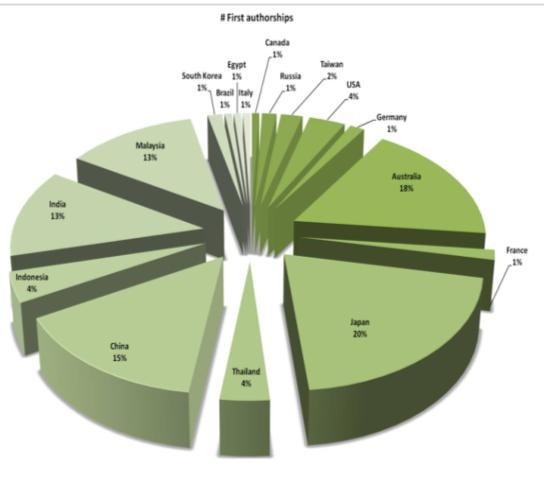

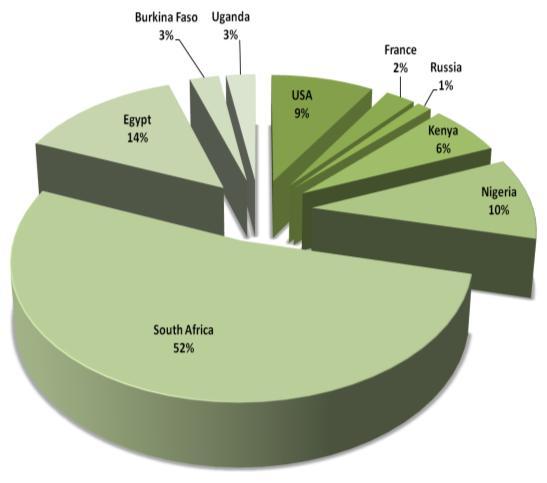
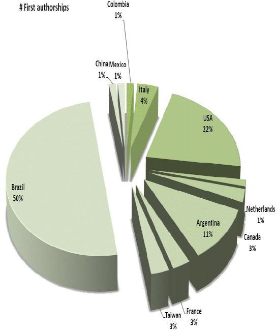
8 Literature Review First authorships distribution MImOSA GINESTRA MEDSTEC

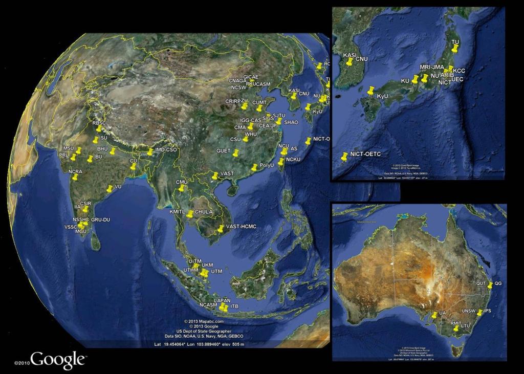
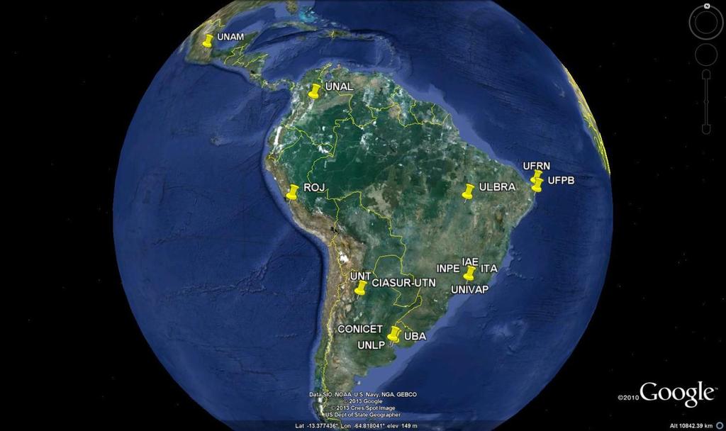
9 Literature Review Identification of Institutions and relevant scientists

10 Literature Review Identification of instruments Standard GNSS receiver GNSS Scintillation Monitor Left: GISTM; right GISM Ionosonde Radar system Left: MST radar Right: Equatorial Atmospheric Radar Sky Imager Magnetometer Video 10


 Hermanus")
11 Contact with local experts The project teams interacted with the local experts by contacts, organizing workshops in the regions of interest and circulating a questionnaire. Hanoi (Vietnam) São José dos Campos (Brazil) Hermanus (South Africa)
12 Key findings In many countries not all the observatories are properly equipped consequently, lack of data sets (researchers working on old data) Set up of networks for data sharing and services welcomed, but some limitations from national regulations Small active scientific community not a popular field among young people Europe is perceived as a reference for training Actions to facilitate visits and study periods in EU Outreach particularly important, raising Government awareness, future funding Personal connections are key Some countries are collecting data, but do not make it publically available Lack of cooperation, need of strategic thinking Data connectivity is a serious problem in the remote areas Remote areas are human resources demanding to maintain the stations and the data flow.

13 Proposed Pilot Projects GINESTRA Background South-eastern Asia ionosphere: EIA + strong amplitude magnetic signature of EEJ over Vietnam. Enhancement of EEJ signature around 100 E confirmed by CHAMP sat unknown origin, but verified relation between EEJ and EIA from TEC measurements along Indian longitudes Proposed topic To perform regional measurements of TEC and geomagnetic field, so as to track EIA evolution and help positioning electron density high gradients within the region. Noon EEJ magnetic signature in August and September 2001 derived by CHAMP satellite measurements. From Doumouya and Cohen, 2004

14 Proposed Pilot Projects MImOSA Background South America: EIA + South Atlantic Magnetic Anomaly (SAMA), a zone where, being the magnetic field strength almost half of what it is when compared to other regions, a large amount of high energy particles penetrate into the upper atmosphere and ionosphere. Topic A federation of European and South American networks and individual instruments, including those already in place and new installations to monitor the southern and northern crests of the EIA and the SAMA. Abdu et al., 2005

15 Proposed Pilot Projects MEDSTEC Background MIDAS (Multi-Instrument Data Analysis System) produces 4D space weather maps from the signals pass through ionosphere and received on Earth by network of scientific receivers. The signals are delayed by different amounts of electron density, this tells us the make-up of the ionosphere. Topic Extend the receivers coverage to give improved ionospheric results particularly in - Algeria, Egypt, D. R. Congo and Niger Left: IRI simulations Middle: MIDAS reconstructions based on all the available data Right: MIDAS reconstructions based on just IGS data Acknowledgement: Alex Chartier, Bath
16 Thanks for your attention!
ESA s activities on ionospheric research and Alcantara initiative Competence Surveys
 ESA s activities on ionospheric research and Alcantara initiative Competence Surveys R. Prieto-Cerdeira, R.Orus-Perez European Space Agency 26/02/2013 Outline ESA activities on ionospheric research at
We are IntechOpen, the world s leading publisher of Open Access books Built by scientists, for scientists. International authors and editors
 We are IntechOpen, the world s leading publisher of Open Access books Built by scientists, for scientists 3,900 116,000 120M Open access books available International authors and editors Downloads Our
An international initiative for atmospheric research at the poles
 An international initiative for atmospheric research at the poles L. Alfonsi 1, Nicolas Bergeot 2, Emilia Correia 3, Domenico Di Mauro 1, Pierre Cilliers 4, Mark Lester 5, Maria Federica Marcucci 6, Cathryn
What is Space Weather? THE ACTIVE SUN
 Aardvark Roost AOC Space Weather in Southern Africa Hannes Coetzee 1 What is Space Weather? THE ACTIVE SUN 2 The Violant Sun 3 What is Space Weather? Solar eruptive events (solar flares, coronal Mass Space
Satellite Navigation Science and Technology for Africa. 23 March - 9 April, The African Ionosphere
 2025-28 Satellite Navigation Science and Technology for Africa 23 March - 9 April, 2009 The African Ionosphere Radicella Sandro Maria Abdus Salam Intern. Centre For Theoretical Physics Aeronomy and Radiopropagation
Hermanus Magnetic Observatory (HMO)
") Hermanus Magnetic Observatory (HMO) As a Space Physics facility in Africa Presented by Danie Gouws & Elda Saunderson The HMO in a nutshell... The Hermanus Magnetic Observatory (HMO) is a national facility
Hermanus Magnetic Observatory (HMO) As a Space Physics facility in Africa Presented by Danie Gouws & Elda Saunderson The HMO in a nutshell... The Hermanus Magnetic Observatory (HMO) is a national facility
Introduction to International Space Weather Initiative (ISWI) and China's Participation (Meridian Project)
 and China's Participation (Meridian Project)") Introduction to International Space Weather Initiative (ISWI) and China's Participation (Meridian Project) Chi Wang National Space Science Center, CAS Nov. 7, 2012 Outline What is Space Weather? International
Introduction to International Space Weather Initiative (ISWI) and China's Participation (Meridian Project) Chi Wang National Space Science Center, CAS Nov. 7, 2012 Outline What is Space Weather? International
The Significance of GNSS for Radio Science
 Space Weather Effects on the Wide Area Augmentation System (WAAS) The Significance of GNSS for Radio Science Patricia H. Doherty Vice Chair, Commission G International Union of Radio Science www.ursi.org
MWA Ionospheric Science Opportunities Space Weather Storms & Irregularities (location location location) John Foster MIT Haystack Observatory
 John Foster MIT Haystack Observatory") MWA Ionospheric Science Opportunities Space Weather Storms & Irregularities (location location location) John Foster MIT Haystack Observatory Storm Enhanced Density: Longitude-specific Ionospheric Redistribution
MWA Ionospheric Science Opportunities Space Weather Storms & Irregularities (location location location) John Foster MIT Haystack Observatory Storm Enhanced Density: Longitude-specific Ionospheric Redistribution
EFFECTS OF SCINTILLATIONS IN GNSS OPERATION
 - - EFFECTS OF SCINTILLATIONS IN GNSS OPERATION Y. Béniguel, J-P Adam IEEA, Courbevoie, France - 2 -. Introduction At altitudes above about 8 km, molecular and atomic constituents of the Earth s atmosphere
International Committee on Global Navigation Satellite Systems (ICG)
") International Committee on Global Navigation Satellite Systems (ICG) A forum to discuss global navigation satellite systems to benefit people around the world Sharafat Gadimova United Nations Office for
International Committee on Global Navigation Satellite Systems (ICG) A forum to discuss global navigation satellite systems to benefit people around the world Sharafat Gadimova United Nations Office for
RELATIONS BETWEEN THE EQUATORIAL VERTICAL DRIFTS, ELECTROJET, GPS-TEC AND SCINTILLATION DURING THE SOLAR MINIMUM
 RELATIONS BETWEEN THE EQUATORIAL VERTICAL DRIFTS, ELECTROJET, GPS-TEC AND SCINTILLATION DURING THE 2008-09 SOLAR MINIMUM Sovit Khadka 1, 2, Cesar Valladares 2, Rezy Pradipta 2, Edgardo Pacheco 3, and Percy
IONOSPHERIC SHORT TERM EMPIRICAL FORECASTING MODEL
 IONOSPHERIC SHORT TERM EMPIRICAL FORECASTING MODEL Giorgiana De Franceschi,, Lucilla Alfonsi, Luca Spogli, Claudio Cesaroni, Vincenzo Romano, Marcin Grzesiak, Andrej Wernik giorgiana.defranceschi@ingv.it
International Committee on Global Navigation Satellite Systems (ICG): Building a System of Systems
: Building a System of Systems") International Committee on Global Navigation Satellite Systems (ICG): Building a System of Systems Outline of Presentation Executive Secretariat of the ICG United Nations Office for Outer Space Affairs
International Committee on Global Navigation Satellite Systems (ICG): Building a System of Systems Outline of Presentation Executive Secretariat of the ICG United Nations Office for Outer Space Affairs
Radio tomography based on satellite beacon experiment and FORMOSAT- 3/COSMIC radio occultation
 Radio tomography based on satellite beacon experiment and FORMOSAT- 3/COSMIC radio occultation Mamoru Yamamoto (1), Smitha V. Thampi (2), Charles Lin (3) (1) RISH, Kyoto University, Japan (2) Space Physics
2 nd ICAO/UNOOSA Symposium, March 2016, Abu Dhabi, UAE. Space Weather. Sharafat Gadimova Office for Outer Space Affairs
 2 nd ICAO/UNOOSA Symposium, 15 17 March 2016, Abu Dhabi, UAE Space Weather Sharafat Gadimova Office for Outer Space Affairs Science, Capacity Building and Outreach 2004: Session of the Committee on the
Space Weather and the Ionosphere
 Dynamic Positioning Conference October 17-18, 2000 Sensors Space Weather and the Ionosphere Grant Marshall Trimble Navigation, Inc. Note: Use the Page Down key to view this presentation correctly Space
The Role of Ground-Based Observations in M-I I Coupling Research. John Foster MIT Haystack Observatory
 The Role of Ground-Based Observations in M-I I Coupling Research John Foster MIT Haystack Observatory CEDAR/GEM Student Workshop Outline Some Definitions: Magnetosphere, etc. Space Weather Ionospheric
ROTI Maps: a new IGS s ionospheric product characterizing the ionospheric irregularities occurrence
 3-7 July 2017 ROTI Maps: a new IGS s ionospheric product characterizing the ionospheric irregularities occurrence Iurii Cherniak Andrzej Krankowski Irina Zakharenkova Space Radio-Diagnostic Research Center,
The Atmosphere and its Effect on GNSS Systems 14 to 16 April 2008 Santiago, Chile
 Description of a Real-Time Algorithm for Detecting Ionospheric Depletions for SBAS and the Statistics of Depletions in South America During the Peak of the Current Solar Cycle The Atmosphere and its Effect
Galileo Information Center for Latin America / Application of the ISMR Query Tool in the analysis of Ionospheric Scintillation from Galileo Satellites
 Galileo Information Center for Latin America / Application of the ISMR Query Tool in the analysis of Ionospheric Scintillation from Galileo Satellites Bruno César Vani Programa de Pós-graduação em Ciências
Space Weather as a Global Challenge
 Space Weather as a Global Challenge IMPC DLR Neustrelitz and Expert Service Centre Ionospheric Weather (I-ESC) Dr. Juergen Drescher DLR Washington Office German Aerospace Center jd@dlr.org German Aerospace
Assimilation Ionosphere Model
 Assimilation Ionosphere Model Robert W. Schunk Space Environment Corporation 399 North Main, Suite 325 Logan, UT 84321 phone: (435) 752-6567 fax: (435) 752-6687 email: schunk@spacenv.com Award #: N00014-98-C-0085
Study of small scale plasma irregularities. Đorđe Stevanović
 Study of small scale plasma irregularities in the ionosphere Đorđe Stevanović Overview 1. Global Navigation Satellite Systems 2. Space weather 3. Ionosphere and its effects 4. Case study a. Instruments
LEO GPS Measurements to Study the Topside Ionospheric Irregularities
 LEO GPS Measurements to Study the Topside Ionospheric Irregularities Irina Zakharenkova and Elvira Astafyeva 1 Institut de Physique du Globe de Paris, Paris Sorbonne Cité, Univ. Paris Diderot, UMR CNRS
Second Workshop on Satellite Navigation Science and Technology for Africa April 2010
 2135-6 Second Workshop on Satellite Navigation Science and Technology for Africa 6-23 April 2010 Update on SCINDA Activities in Africa and Around the Globe R. Caton AFRL Hansom USA An Update on SCINDA
Present Status and Future Plan of Ionospheric Observation and Research in LAPAN
 Present Status and Future Plan of Ionospheric Observation and Research in LAPAN Buldan Muslim 1), Jiyo 1), Asnawi 1) and Dyah R.M. 1) 1) Space Science Center National Institute of Aeronautics and Space
Storms in Earth s ionosphere
 Storms in Earth s ionosphere Archana Bhattacharyya Indian Institute of Geomagnetism IISF 2017, WSE Conclave; Anna University, Chennai Earth s Ionosphere Ionosphere is the region of the atmosphere in which
Observations of Ionosphere/Troposphere Coupling as Observed by COSMIC
 Observations of Ionosphere/Troposphere Coupling as Observed by COSMIC K. F. Dymond, C. Coker, D. E. Siskind, A. C. Nicholas, S. A. Budzien, S. E. McDonald, and C. E. Dymond * Space Science Division, Naval
Ionospheric Monitoring in China. Zhen Weimin, Ou Ming
 ICG-5 WG-B, Turino Ionospheric Monitoring in China Zhen Weimin, Ou Ming October 20 th, 2010, Turino, Italy Outline 1.Introduction 2.Ionosphere monitoring in China 3.Summary 1. Introduction GNSS performance
Activities of the JPL Ionosphere Group
 Activities of the JPL Ionosphere Group On-going GIM wor Submit rapid and final GIM TEC maps for IGS combined ionosphere products FAA WAAS & SBAS analysis Error bounds for Brazilian sector, increasing availability
On the Importance of Radio Occultation data for Ionosphere Modeling
 On the Importance of Radio Occultation data for Ionosphere Modeling IROWG Workshop, Estes Park, March 30, 2012 ABSTRACT The availability of unprecedented amounts of Global Navigation Satellite Systems
NAVIGATION SYSTEMS PANEL (NSP) NSP Working Group meetings. Impact of ionospheric effects on SBAS L1 operations. Montreal, Canada, October, 2006
 NSP Working Group meetings. Impact of ionospheric effects on SBAS L1 operations. Montreal, Canada, October, 2006") NAVIGATION SYSTEMS PANEL (NSP) NSP Working Group meetings Agenda Item 2b: Impact of ionospheric effects on SBAS L1 operations Montreal, Canada, October, 26 WORKING PAPER CHARACTERISATION OF IONOSPHERE
NAVIGATION SYSTEMS PANEL (NSP) NSP Working Group meetings Agenda Item 2b: Impact of ionospheric effects on SBAS L1 operations Montreal, Canada, October, 26 WORKING PAPER CHARACTERISATION OF IONOSPHERE
[EN-107] Impact of the low latitude ionosphere disturbances on GNSS studied with a three-dimensional ionosphere model
![[EN-107] Impact of the low latitude ionosphere disturbances on GNSS studied with a three-dimensional ionosphere model](/thumbs/86/93972301.jpg "[EN-107] Impact of the low latitude ionosphere disturbances on GNSS studied with a three-dimensional ionosphere model") ENRI Int. Workshop on ATM/CNS. Tokyo, Japan (EIWAC21) [EN-17] Impact of the low latitude ionosphere disturbances on GNSS studied with a three-dimensional ionosphere model + S. Saito N. FUjii Communication
ENRI Int. Workshop on ATM/CNS. Tokyo, Japan (EIWAC21) [EN-17] Impact of the low latitude ionosphere disturbances on GNSS studied with a three-dimensional ionosphere model + S. Saito N. FUjii Communication
ICTP- TREGA project Sharing experience with Euromed neighbouring countries
 07/05/2015 Euromed GNSSII/MEDUSA project, Tunis 1 ICTP- TREGA project Sharing experience with Euromed neighbouring countries H.R. Ngaya,C. Paparini, O.E. Abe, X. Otero Villamide, S. M. Radicella, B. Nava
Investigations of Global Space Weather with GPS
 Investigations of Global Space Weather with GPS A. J. Coster, J. Foster, F. Lind, P. Erickson MIT Haystack Observatory J. Semeter Boston University E. Yizengaw Boston College Overview Space weather can
Ionospheric Effects on Aviation
 Ionospheric Effects on Aviation Recent experience in the observation and research of ionospheric irregularities, gradient anomalies, depletion walls, etc. in USA and Europe Stan Stankov, René Warnant,
Imaging of the equatorial ionosphere
 ANNALS OF GEOPHYSICS, VOL. 48, N. 3, June 2005 Imaging of the equatorial ionosphere Massimo Materassi ( 1 ) and Cathryn N. Mitchell ( 2 ) ( 1 ) Istituto dei Sistemi Complessi, CNR, Sesto Fiorentino (FI),
Study of the Ionosphere Irregularities Caused by Space Weather Activity on the Base of GNSS Measurements
 Study of the Ionosphere Irregularities Caused by Space Weather Activity on the Base of GNSS Measurements Iu. Cherniak 1, I. Zakharenkova 1,2, A. Krankowski 1 1 Space Radio Research Center,, University
Quickmaps and history of the effects of ionospheric scintillations on GPS/GLONASS signals. Summary. Applications. Introduction
 Quickmaps and history of the effects of ionospheric scintillations on GPS/GLONASS signals A proposal to ESA Pilot Project for Space Weather Applications J.J. Valette, B. Nhun Fat, P. Yaya 1 In partnership
A study of the ionospheric effect on GBAS (Ground-Based Augmentation System) using the nation-wide GPS network data in Japan
 using the nation-wide GPS network data in Japan") A study of the ionospheric effect on GBAS (Ground-Based Augmentation System) using the nation-wide GPS network data in Japan Takayuki Yoshihara, Electronic Navigation Research Institute (ENRI) Naoki Fujii,
A study of the ionospheric effect on GBAS (Ground-Based Augmentation System) using the nation-wide GPS network data in Japan Takayuki Yoshihara, Electronic Navigation Research Institute (ENRI) Naoki Fujii,
Chapter 2 Analysis of Polar Ionospheric Scintillation Characteristics Based on GPS Data
 Chapter 2 Analysis of Polar Ionospheric Scintillation Characteristics Based on GPS Data Lijing Pan and Ping Yin Abstract Ionospheric scintillation is one of the important factors that affect the performance
16502/14 GT/nj 1 DG G 3 C
 Council of the European Union Brussels, 8 December 2014 (OR. en) 16502/14 OUTCOME OF PROCEEDINGS From: To: Council Delegations ESPACE 92 COMPET 661 RECH 470 IND 372 TRANS 576 CSDP/PSDC 714 PESC 1279 EMPL
The Ionosphere and its Impact on Communications and Navigation. Tim Fuller-Rowell NOAA Space Environment Center and CIRES, University of Colorado
 The Ionosphere and its Impact on Communications and Navigation Tim Fuller-Rowell NOAA Space Environment Center and CIRES, University of Colorado Customers for Ionospheric Information High Frequency (HF)
Ionospheric dynamics over South America observed by TEC mapping
 ANGWIN Workshop 2018, INPE São José dos Campos, SP, Brazil Ionospheric dynamics over South America observed by TEC mapping H. Takahashi, C. M. Wrasse, C. A. O. B. Figueiredo, D. Barros, M. A. Abdu (INPE,
Experiences with Fugro's Real Time GPS/GLONASS Orbit/Clock Decimeter Level Precise Positioning System
 Return to Session Directory DYNAMIC POSITIONING CONFERENCE October 13-14, 2009 Sensors Experiences with Fugro's Real Time GPS/GLONASS Orbit/Clock Decimeter Level Precise Positioning System Ole Ørpen and
Ionospheric Radio Occultation Measurements Onboard CHAMP
 Ionospheric Radio Occultation Measurements Onboard CHAMP N. Jakowski 1, K. Tsybulya 1, S. M. Stankov 1, V. Wilken 1, S. Heise 2, A. Wehrenpfennig 3 1 DLR / Institut für Kommunikation und Navigation, Kalkhorstweg
Attenuation of GPS scintillation in Brazil due to magnetic storms
 SPACE WEATHER, VOL. 6,, doi:10.1029/2006sw000285, 2008 Attenuation of GPS scintillation in Brazil due to magnetic storms E. Bonelli 1 Received 21 September 2006; revised 15 June 2008; accepted 16 June
Regional ionospheric disturbances during magnetic storms. John Foster
 Regional ionospheric disturbances during magnetic storms John Foster Regional Ionospheric Disturbances John Foster MIT Haystack Observatory Regional Disturbances Meso-Scale (1000s km) Storm Enhanced Density
Report on the United Nations/Croatia Workshop on the Applications of Global Navigation Satellite Systems
 United Nations General Assembly Distr.: General 3 September 2013 Original: English Committee on the Peaceful Uses of Outer Space Report on the United Nations/Croatia Workshop on the Applications of Global
Monitoring of the Geo-Plasma Environment
 Monitoring of the Geo-Plasma Environment MOPLE N. Jakowski and S. S. M. Stankov MOPLE MOPLE submitted as as EoI EoIfor for FP6 FP6 by: by: Deutsches Zentrum für für Luft- Luft-und und Raumfahrt e.v. e.v.
Outline. GPS RO Overview. COSMIC Overview. COSMIC-2 Overview. Summary 9/29/16
 Bill Schreiner and UCAR/COSMIC Team UCAR COSMIC Program Observation and Analysis Opportunities Collaborating with the ICON and GOLD Missions Sept 27, 216 GPS RO Overview Outline COSMIC Overview COSMIC-2
Polar Ionospheric Imaging at Storm Time
 Ms Ping Yin and Dr Cathryn Mitchell Department of Electronic and Electrical Engineering University of Bath BA2 7AY UNITED KINGDOM p.yin@bath.ac.uk / eescnm@bath.ac.uk Dr Gary Bust ARL University of Texas
Analysis of equatorial ionospheric irregularities based on a two high rate GNSS station setup
 Analysis of equatorial ionospheric irregularities based on a two high rate GNSS station setup Jens Berdermann 1,Norbert Jakowski 1, Martin Kriegel 1, Hiroatsu Sato 1, Volker Wilken 1, Stefan Gewies 1,
INVESTIGATION OF LOW LATITUDE SCINTILLATIONS IN BRAZIL WITHIN THE CIGALA PROJECT
 INVESTIGATION OF LOW LATITUDE SCINTILLATIONS IN BRAZIL WITHIN THE CIGALA PROJECT Vincenzo Romano (1), Bruno Bougard (2), Marcio Aquino (3), Joao F. Galera Monico (4), Tom Willems (2), Marc Solé (5) (1)
Present and future IGS Ionospheric products
 Present and future IGS Ionospheric products Andrzej Krankowski, Manuel Hernández-Pajares, Joachim Feltens, Attila Komjathy, Stefan Schaer, Alberto García-Rigo, Pawel Wielgosz Outline Introduction IGS IONO
GNSS remote sensing (GNSS-RS)
") GPS Galileo GLONASS Beidou GNSS remote sensing (GNSS-RS) Shuanggen Jin ( 金双根 ) Shanghai Astronomical Observatory, CAS, Shanghai 200030, China Email: sgjin@shao.ac.cn Website: http://www.shao.ac.cn/geodesy
GPS Galileo GLONASS Beidou GNSS remote sensing (GNSS-RS) Shuanggen Jin ( 金双根 ) Shanghai Astronomical Observatory, CAS, Shanghai 200030, China Email: sgjin@shao.ac.cn Website: http://www.shao.ac.cn/geodesy
Operational Products of the Space Weather Application Center Ionosphere (SWACI) and capabilities of their use
 and capabilities of their use") Operational Products of the Space Weather Application Center Ionosphere (SWACI) and capabilities of their use N. Jakowski, C. Borries, V. Wilken, K.D. Missling, H. Barkmann, M. M. Hoque, M. Tegler, C.
Operational Products of the Space Weather Application Center Ionosphere (SWACI) and capabilities of their use N. Jakowski, C. Borries, V. Wilken, K.D. Missling, H. Barkmann, M. M. Hoque, M. Tegler, C.
Report of Regional Warning Centre INDIA, Annual Report
 Report of Regional Warning Centre INDIA, 2013-2014 Annual Report A.K Upadhayaya Radio and Atmospheric Sciences Division, National Physical Laboratory, New Delhi-110012, India Email: upadhayayaak@nplindia.org
RESEARCH ACTIVITIES AT INPE USING GPS RECEIVERS. Eurico R. de Paula, Ivan J. Kantor and Luiz Felipe C. de Rezende INPE- São José dos Campos São Paulo
 RESEARCH ACTIVITIES AT INPE USING GPS RECEIVERS Eurico R. de Paula, Ivan J. Kantor and Luiz Felipe C. de Rezende INPE- São José dos Campos São Paulo OUTLINE -GPS RECEIVERS LOCATION OVER BRAZIL -IONOSPHERIC
Day-to-day Variations in the Solar Quiet (Sq) Current System
 Current System") 14th International Symposium on Equatorial Aeronomy (ISEA) Bahir Dar, Ethiopia, 19 October 2015 Day-to-day Variations in the Solar Quiet (Sq) Current System Yosuke Yamazaki (YY) Department of Physics,
14th International Symposium on Equatorial Aeronomy (ISEA) Bahir Dar, Ethiopia, 19 October 2015 Day-to-day Variations in the Solar Quiet (Sq) Current System Yosuke Yamazaki (YY) Department of Physics,
The Ionosphere and Thermosphere: a Geospace Perspective
 The Ionosphere and Thermosphere: a Geospace Perspective John Foster, MIT Haystack Observatory CEDAR Student Workshop June 24, 2018 North America Introduction My Geospace Background (Who is the Lecturer?
Using the Radio Spectrum to Understand Space Weather
 Using the Radio Spectrum to Understand Space Weather Ray Greenwald Virginia Tech Topics to be Covered What is Space Weather? Origins and impacts Analogies with terrestrial weather Monitoring Space Weather
GPS TEC Measurements Utilized for Monitoring Recent Space Weather Events and Effects in Europe
 GPS TEC Measurements Utilized for Monitoring Recent Space Weather Events and Effects in Europe S. M. Stankov (1), N. Jakowski (2), B. Huck (3) (1) German Aerospace Center (DLR) Institute of Communications
ESA Space Weather Study, Final Presentation: Implementation Plan
 ESA Space Weather Study, Final Presentation: Implementation Plan Mike Hapgood CLRC Rutherford Appleton Laboratory 6 December 2001, ESTEC specify elements Data ORGANISATIONAL PLAN NETWORK FOR GROUND-BASED
Preliminary results of ionosphere measurement from GNOS on China FY-3C satellite
 Preliminary results of ionosphere measurement from GNOS on China FY-3C satellite Guanglin Yang 1, Tian Mao 1, Lingfeng Sun 2, Xinan Yue 3, Weihua Bai 4 and Yueqiang Sun 4 1 National Satellite Meteorological
The ICG, Multifunction GNSS Signals and How To Protect Them. Space Weather Studies Using GNSS and Space Science Outreach activities at Sangli
 4 th EUROPEAN SPACE SOLUTIONS The ICG, Multifunction GNSS Signals and How To Protect Them Space Weather Studies Using GNSS and Space Science Outreach activities at Sangli D. J. SHETTI DEPARTMENT OF PHYSICS,
Effects of magnetic storms on GPS signals
 Effects of magnetic storms on GPS signals Andreja Sušnik Supervisor: doc.dr. Biagio Forte Outline 1. Background - GPS system - Ionosphere 2. Ionospheric Scintillations 3. Experimental data 4. Conclusions
GPS=GLONASS-based TEC measurements as a contributor for space weather forecast
 Journal of Atmospheric and Solar-Terrestrial Physics 64 (2002) 729 735 www.elsevier.com/locate/jastp GPS=GLONASS-based TEC measurements as a contributor for space weather forecast N. Jakowski, S. Heise,
Overview of the global GNSS market and status of Galileo
 2012 GNSS.asia workshop Overview of the global GNSS market and status of Galileo 6 November, 2012 Taipei Justyna Redelkiewicz, European GNSS Agency European GNNS Agency supports European Commission in
Spatial and temporal extent of ionospheric anomalies during sudden stratospheric warmings in the daytime ionosphere
 Spatial and temporal extent of ionospheric anomalies during sudden stratospheric warmings in the daytime ionosphere Larisa Goncharenko, Shunrong Zhang, Anthea Coster, Leonid Benkevitch, Massachusetts Institute
Understanding the unique equatorial electrodynamics in the African Sector
 Understanding the unique equatorial electrodynamics in the African Sector Endawoke Yizengaw, Keith Groves, Tim Fuller-Rowell, Anthea Coster Science Background Satellite observations (see Figure 1) show
ELECTROMAGNETIC PROPAGATION (ALT, TEC)
") ELECTROMAGNETIC PROPAGATION (ALT, TEC) N. Picot CNES, 18 Av Ed Belin, 31401 Toulouse, France Email : Nicolas.Picot@cnes.fr ABSTRACT For electromagnetic propagation, the ionosphere plays a key role. This
ELECTROMAGNETIC PROPAGATION (ALT, TEC) N. Picot CNES, 18 Av Ed Belin, 31401 Toulouse, France Email : Nicolas.Picot@cnes.fr ABSTRACT For electromagnetic propagation, the ionosphere plays a key role. This
Satellite Simulator for Verification of Mission Operational Concepts in Pre-Phase A Studies
 Instituto Nacional de Pesquisas Espaciais 1/ 23 Instituto Nacional de Pesquisas Espaciais Space Technology and Engineering Space Systems Division São José dos Campos, São Paulo, Brazil Satellite Simulator
International Committee on GNSS: The Way Forward to Provide Positioning, Navigation and Timing Globally
 High Level Forum: Space as a Driver for Socio-Economic Sustainable Development, 20 24 November 2016, Dubai, UAE International Committee on GNSS: The Way Forward to Provide Positioning, Navigation and Timing
JOURNAL OF GEOPHYSICAL RESEARCH, VOL. 115, A03301, doi: /2009ja014788, 2010
 Click Here for Full Article JOURNAL OF GEOPHYSICAL RESEARCH, VOL. 115,, doi:10.1029/2009ja014788, 2010 Scintillation producing Fresnel scale irregularities associated with the regions of steepest TEC gradients
MEETING OF THE METEOROLOGY PANEL (METP) METEOROLOGICAL INFORMATION AND SERVICE DEVELOPMENT WORKING GROUP (WG-MISD)
 METEOROLOGICAL INFORMATION AND SERVICE DEVELOPMENT WORKING GROUP (WG-MISD)") METP-WG/MISD/1-IP/09 12/11/15 MEETING OF THE METEOROLOGY PANEL (METP) METEOROLOGICAL INFORMATION AND SERVICE DEVELOPMENT WORKING GROUP (WG-MISD) FIRST MEETING Washington DC, United States, 16 to 19 November
METP-WG/MISD/1-IP/09 12/11/15 MEETING OF THE METEOROLOGY PANEL (METP) METEOROLOGICAL INFORMATION AND SERVICE DEVELOPMENT WORKING GROUP (WG-MISD) FIRST MEETING Washington DC, United States, 16 to 19 November
Jøran Moen University of Oslo Also at The University Centre in Svalbard
 The ICI series of Space Weather Rockets Jøran Moen University of Oslo Also at The University Centre in Svalbard GPS ERROR SOURCES Courtesy of Alfonsi IONOSPHERIC EFFECTS ON GPS SIGNALS L-band scintillations
Special Thanks: M. Magoun, M. Moldwin, E. Zesta, C. Valladares, and AMBER, SCINDA, & C/NOFS teams
 Longitudinal Variability of Equatorial Electrodynamics E. Yizengaw 1, J. Retterer 1, B. Carter 1, K. Groves 1, and R. Caton 2 1 Institute for Scientific Research, Boston College 2 AFRL, Kirtland AFB, NM,
Geomagnetic Indices Forecasting and Ionospheric Nowcasting Tools Work Package 200 INT (Ionosphere Nowcasting Tool) Preliminary considerations.
 Preliminary considerations.") Geomagnetic Indices Forecasting and Ionospheric Nowcasting Tools Work Package 2 INT (Ionosphere Nowcasting Tool) B. Zolesi *, Lj. Cander ** and A. Belehaki *** * Istituto Nazionale di Geofisica e Vulcanologia,
Geomagnetic Indices Forecasting and Ionospheric Nowcasting Tools Work Package 2 INT (Ionosphere Nowcasting Tool) B. Zolesi *, Lj. Cander ** and A. Belehaki *** * Istituto Nazionale di Geofisica e Vulcanologia,
GPS Ray Tracing to Show the Effect of Ionospheric Horizontal Gradeint to L 1 and L 2 at Ionospheric Pierce Point
 Proceeding of the 2009 International Conference on Space Science and Communication 26-27 October 2009, Port Dickson, Negeri Sembilan, Malaysia GPS Ray Tracing to Show the Effect of Ionospheric Horizontal
Space weather Application Center Ionosphere A Near-Real-Time Service Based on NTRIP Technology
 Space weather Application Center Ionosphere A Near-Real-Time Service Based on NTRIP Technology N. Jakowski, S. M. Stankov, D. Klaehn, C. Becker German Aerospace Center (DLR), Institute of Communications
THIRD TRANSMIT SUMMER SCHOOL
 THIRD TRANSMIT SUMMER SCHOOL 1-5 July (Monday-Friday) 2013 Istituto Nazionale di Geofisica e Vulcanologia Via Di Vigna Murata 605 00143 Rome Italy Ionospheric threats to Europe: impact of increased solar
European GNSS Evolution
 Ref. Ares(204)902599 - /06/204 European GNSS Evolution Hermann Ebner Galileo and EGNOS Programme Management DG Enterprise and Industry Content Introduction 2 2 Major Challenges for EGNSS Evolution 3 EGNSS
IRI-Plas Optimization Based Ionospheric Tomography
 IRI-Plas Optimization Based Ionospheric Tomography Onur Cilibas onurcilibas@gmail.com.tr Umut Sezen usezen@hacettepe.edu.tr Feza Arikan arikan@hacettepe.edu.tr Tamara Gulyaeva IZMIRAN 142190 Troitsk Moscow
Scientific Studies of the High-Latitude Ionosphere with the Ionosphere Dynamics and ElectroDynamics - Data Assimilation (IDED-DA) Model
 Model") DISTRIBUTION STATEMENT A. Approved for public release; distribution is unlimited. Scientific Studies of the High-Latitude Ionosphere with the Ionosphere Dynamics and ElectroDynamics - Data Assimilation
DISTRIBUTION STATEMENT A. Approved for public release; distribution is unlimited. Scientific Studies of the High-Latitude Ionosphere with the Ionosphere Dynamics and ElectroDynamics - Data Assimilation
USE OF EGNOS AND GALILEO FOR SCIENTIFIC APPLICATIONS & INNOVATIVE APPLICATIONS IN NEW DOMAINS
 USE OF EGNOS AND GALILEO FOR SCIENTIFIC APPLICATIONS & INNOVATIVE APPLICATIONS IN NEW DOMAINS Carmen Aguilera Market Development Project Officer European GNSS Supervisory Authority 1 1 GALILEO TECHNICAL
A first study into the propagation of 5 MHz (60 m) signals using the South African ionosonde network
 signals using the South African ionosonde network") A first study into the propagation of 5 MHz (60 m) signals using the South African ionosonde network Hannes Coetzee, B. Eng. (Electronics), M. Sc. (Physics), ZS6BZP The SARL has purchased two 5 MHz test
A first study into the propagation of 5 MHz (60 m) signals using the South African ionosonde network Hannes Coetzee, B. Eng. (Electronics), M. Sc. (Physics), ZS6BZP The SARL has purchased two 5 MHz test
EVALUATION OF THE EXTENSION AND DEGRADATION OF MANGROVE AREAS IN SERGIPE STATE WITH REMOTE SENSING DATA
 EVALUATION OF THE EXTENSION AND DEGRADATION OF MANGROVE ABSTRACT AREAS IN SERGIPE STATE WITH REMOTE SENSING DATA Myrian M. Abdon Ernesto G.M.Vieira Carmem R.S. Espindola Alberto W. Setzer Instituto de
Three-dimensional and numerical ray tracing on a phenomenological ionospheric model
 Three-dimensional and numerical ray tracing on a phenomenological ionospheric model Lung-Chih Tsai 1, 2, C. H. Liu 3, T. Y. Hsiao 4, and J. Y. Huang 1 (1) Center for Space and Remote Sensing research,
PoS(2nd MCCT -SKADS)003
003") The Earth's ionosphere: structure and composition. Dispersive effects, absorption and emission in EM wave propagation 1 Observatorio Astronómico Nacional Calle Alfonso XII, 3; E-28014 Madrid, Spain E-mail:
The Earth's ionosphere: structure and composition. Dispersive effects, absorption and emission in EM wave propagation 1 Observatorio Astronómico Nacional Calle Alfonso XII, 3; E-28014 Madrid, Spain E-mail:
Assimilation Ionosphere Model
 Assimilation Ionosphere Model Robert W. Schunk Space Environment Corporation 221 North Spring Creek Parkway, Suite A Providence, UT 84332 phone: (435) 752-6567 fax: (435) 752-6687 email: schunk@spacenv.com
Operational Space Environment Network Display (OpSEND)
") RADIO SCIENCE, VOL. 39,, doi:10.1029/2002rs002836, 2004 Operational Space Environment Network Display (OpSEND) Gregory Bishop, 1 Terence Bullett, 1 Keith Groves, 1 Stephen Quigley, 1 Patricia Doherty,
RADIO SCIENCE, VOL. 39,, doi:10.1029/2002rs002836, 2004 Operational Space Environment Network Display (OpSEND) Gregory Bishop, 1 Terence Bullett, 1 Keith Groves, 1 Stephen Quigley, 1 Patricia Doherty,
TrigNet: The South African Network of Continuously Operating GNSS Base Stations
 TrigNet: The South African Network of Continuously Operating GNSS Base Stations R Wonnacott ESESA User Need Workshop Thread 2: Status of Current GNSS Applications in South Africa Somerset West 2 March
Ionospheric Imprint to LOFAR
 Ionospheric Imprint to LOFAR Norbert Jakowski Institute of Communications und Navigation German Aerospace Center Kalkhorstweg 53, D-17235 Neustrelitz, Germany LOFAR Workshop, 8/9 November 2010, Potsdam,
1. Terrestrial propagation
 Rec. ITU-R P.844-1 1 RECOMMENDATION ITU-R P.844-1 * IONOSPHERIC FACTORS AFFECTING FREQUENCY SHARING IN THE VHF AND UHF BANDS (30 MHz-3 GHz) (Question ITU-R 218/3) (1992-1994) Rec. ITU-R PI.844-1 The ITU
GNSS Ionospheric Activities in JRC-ISPRA
 GNSS Ionospheric Activities in JRC-ISPRA M. Zürn, J. Curran, M. Bavaro, J. Fortuny EC Joint Research Centre Institute for the Protection and Security of the Citizen Ispra (Italy) WMO SWx WG Meeting, Ispra,
Introduction to ILWS. George Withbroe. Office of Space Science Sun Earth Connection Division NASA Headquarters
 Introduction to ILWS George Withbroe Office of Space Science Sun Earth Connection Division NASA Headquarters GOAL: Stimulate and strengthen research in solar-terrestrial physics to improve understanding
Space Weather influence on satellite based navigation and precise positioning
 Space Weather influence on satellite based navigation and precise positioning R. Warnant, S. Lejeune, M. Bavier Royal Observatory of Belgium Avenue Circulaire, 3 B-1180 Brussels (Belgium) What this talk
Influence of Major Geomagnetic Storms Occurred in the Year 2011 On TEC Over Bangalore Station In India
 International Journal of Electronics and Communication Engineering. ISSN 0974-2166 Volume 6, Number 1 (2013), pp. 105-110 International Research Publication House http://www.irphouse.com Influence of Major