ROTI Maps: a new IGS s ionospheric product characterizing the ionospheric irregularities occurrence
|
|
|
- Mildred Oliver
- 6 years ago
- Views:
Transcription

1 3-7 July 2017 ROTI Maps: a new IGS s ionospheric product characterizing the ionospheric irregularities occurrence Iurii Cherniak Andrzej Krankowski Irina Zakharenkova Space Radio-Diagnostic Research Center, University of Warmia and Mazury, Olsztyn, Poland
")

2 Introduction. Ionosphere Ionosphere is the part of the Earth s atmosphere, consisting of several ionized layers and extending from about 50 km up to 1,000 km. Plasma density distribution in the ionosphere varies with: altitude day/night seasons latitude/longitude solar activity geomagnetic conditions Global ionospheric maps of total electron content (TEC) IGS GIMs Image credit: UWM Equatorial Region: strongest effects; highest; strongest TEC gradients; Irregularities not correlated with magnetic activity Mid-Latitude Region: normally quiescent but with strong gradients during extreme levels of geomagnetic activity Auroral Region: aurora and structures. Phase scintillations. Ionosphere-plasmasphere system (courtesy of the Windows to the Universe) Electron density distribution with altitude


3 Introduction. GNSS signals propagation The ionosphere medium where GNSS signals pass a long distance. The ionosphere delay is the significant error source for satellite navigation systems, but it can be directly measured and mitigated with using dual frequency GNSS receivers. Dual frequency GPS measurements can effectively provide integral information on the electron density along the ray path by computing differential phases of code and carrier phase measurements. The integral of the electron density along the ray path (TEC) between the transmitting GNSS satellite and the receiver.

4 Motivation Ionospheric irregularities and trans-ionospheric radiowaves propagation Global distribution of ionospheric scintillation during high and low solar activity (Basu. et al., J. Atmos. Terr. Phys, 2002)
5 The open questions: When and where high-latitude ionospheric plasma irregularities are developed? Our task: Monitoring of the ionospheric irregularities over the Northern Hemisphere. Our approach: The TEC rapid changes analysis on the base of GPS signal measurements
6 Methodology Basic approach: 1. The Rate of TEC (dtec/dt) calculation ROT = i TECk TEC ( t t ) 1 k k i k 1 t = t k t k 1 = 1 min. 2. The Rate of TEC Index (ROTI) estimation ROTI = ROT 2 ROT 2 Standard deviation of ROT (on 5 min intervals)
7 Methodology
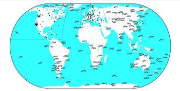
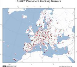
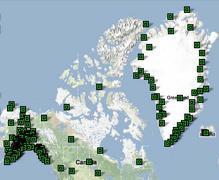
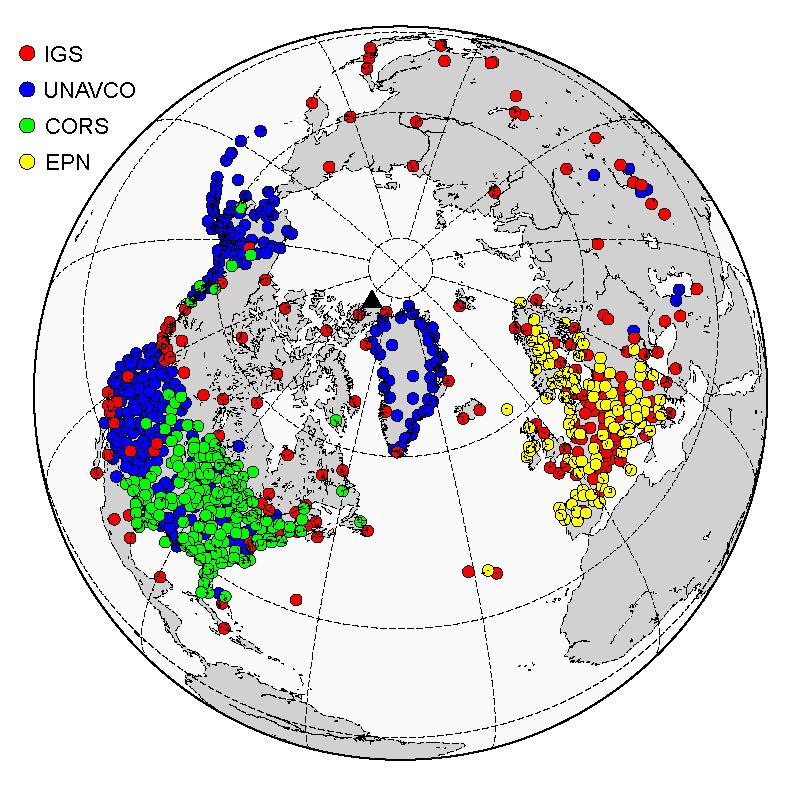
8 Methodology Data sources: > 700 stations IGS UNAVCO

")
9 Methodology Basic approach: 3. The Rate of TEC Index mapping Ionospheric plasma variability drivers: - Solar radiation - Geomagnetic field The coordinates system: Magnetic local time (MLT) and corrected magnetic latitude (MLAT)


10 ROTI Maps Product Steps of ROTI Maps product generation at UWM:
11 ROTI Maps Product Steps of ROTI Maps product generation at UWM: The ROTI Maps latency Input data Latency Availability N Processing phase Processing time GPS observations ftp://data-out.unavco. org/pub/rinex/obs/ ftp://epncb.oma.be/ pub/obs/ GPS orbit data ftp://cddis.gsfc.nasa. gov/pub/gps/products/ 6h 12h 20h 12h 24h 30% 50% 75% Non avaliable Avaliable Data collection Quality check Data processing Final product generation Total 2h 1h 2,5h 5 min 5h 40 min The product latency is determined on the input data availability and it takes more 48 h.

12 ROTI Maps Product ROTI Maps format The output maps provided in the ASCII formats. This data prepared in the IONEX-like format on grid 2 x 2 degree - geomagnetic latitude from 51 o to 89 o with step 2 o and corresponded to magnetic local time (00-24 MLT) polar coordinates from 0 to 359. The sample of the ROTI Maps output: ASCII format.

13 ROTI Maps Product ROTI Maps visualization
14 ROTI Maps Product ROTI Maps visualization

15 ROTI Maps Product ROTI Maps visualization
16 ROTI Maps Product The ROTI Maps product generation at UWM: The UWM ROTI Maps processor operates routinely since January, 1, It was processed and collected data and resulted product from 2010up to now since the test service established. There is no gaps in the ROTI Maps product dataset for test period. The ROTI maps product validation activity on dataset. ROTI Maps product for available since March 2017 on CDDIS. Cherniak et al., GPS Solution, 2017 Detailed description of the ROTI Maps Product will be available in paper Cherniak et al., GPS Solution, 2017 (under review).
. Beniguel et al.")
17 ROTI Maps Product The ROTI maps product have been validated within framework of Monitor-2 European Space Agency Project ( dataset). Beniguel et al., 2016, AnnGeo.

18 ROTI Maps Product. Scientific Applications St. Patrick s Day Storm Largest storm for last 10 years Intense particle precipitation Aurora was registered at mid-latitudes (Cherniak et al,, AGU SW, 2015


19 B. Wanner, WAAS Technical Report: Iono activity affected WAAS performance in Canada, Alaska, and CONUS on March 17 and March 18
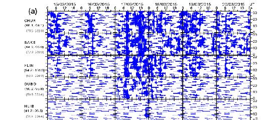

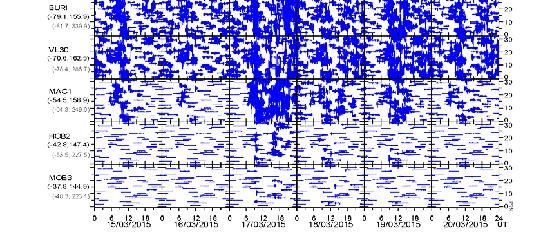
20 ROT variability America Europe
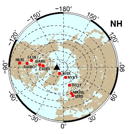
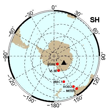
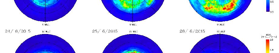
21 Diurnal ROTI maps Northern Hemisphere Southern Hemisphere Cherniak et al., SW, 2015


22 Diurnal ROTI maps vs patterns of auroral particle energy flux TIROS/NOAA Auroral Observations Image credit: SRI International

23 Dynamics of ionospheric irregularities: Hourly ROTI maps Quiet Day

24 Dynamics of ionospheric irregularities: Storm day
25 SED/TOI
26 ROTI Maps Product. Scientific Applications. Expending to LEO Advantages of multi-satellite observations: Swarm A, Swarm C, Swarm B, GRACE, TerraSAR-X Cherniak and Zakharenkova, EPS, 2016

27 Duirnal ROTI maps: Ground GPS vs LEO GPS Application of ROTI mapping technique to LEO GPS measurements.
28 ROTI Maps Product. Scientific Applications. GPS ROTI and Swarm plasma density probe Swarm LP data confirm electron density enhancement in SED/TOI and ionospheric irregularities structure.
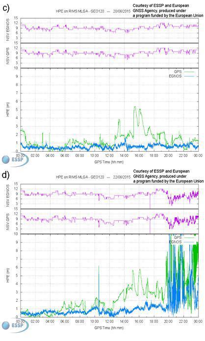
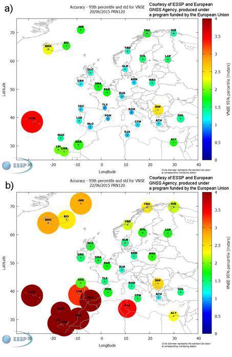
 Rate of TEC (ionospheric total electron content) index (ROTI) (colored lines) and in situ (thick black line) observations.")
29 SuperDARN polar potential maps for the Southern Hemisphere at a 18.4 UT and b 18.8 UT, and the Northern Hemisphere at c 18.0 UT with superimposed low earth orbit (LEO) Rate of TEC (ionospheric total electron content) index (ROTI) (colored lines) and in situ (thick black line) observations. Black dot indicates the position of the magnetic pole. The right-hand panel shows Swarm electron density (Ne) and LEO TEC variations for corresponding tracks on the maps. UT and geographic latitude and longitude are noted at the bottom axes. Data tracks are line of sight between two points, e.g., SWA-GPS 19 denotes the data between SWA and GPS PRN 19. TEC data are the relative slant TEC measurements. ROTI is shown in units of TECU/min. Minutes are indicated in decimal format
30 June 2015 Storm Bz (nt) Vsw (km/s) Psw (npa) AE (nt) SYM-H (nt) June 2015


31 Diurnal ROTI maps

32 Dynamics of ionospheric irregularities: Quiet day

33 Dynamics of ionospheric irregularities: Storm day
34
 Two-dimensional maps of vertical TEC with superimposed Swarm A and Swarm B passes (magenta lines) for 23 UT and 01 UT, respectively; in situ electron density")
35 Two-dimensional ROTI maps of ionospheric irregularities in geographic coordinates over Europe with 1 h interval during 18 UT 05 UT on June Cherniak and Zakharenkova, GRL, 2016 (b) Two-dimensional maps of vertical TEC with superimposed Swarm A and Swarm B passes (magenta lines) for 23 UT and 01 UT, respectively; in situ electron density and topside vertical TEC along these passes are shown at small panels on the right. Numerous plasma depletions are embedded into high TEC plasma within N.

36 The (left) global view with Swarm A satellite passes and spaceborne GPS ROTI; (right) variation of in situ electron density Ne as a function of geographical latitude along these passes. Black lines on latitudinal profiles present Ne values for June; thin blue lines are quiet-time conditions of June Universal time (UT) and geographic longitude for each satellite pass are given at the top of graphs. The yellow shaded area indicates deep plasma depletions in Europe and its close vicinity. (b) The same as Figure 1a but for Swarm B satellite. (c) The passes of DMSP F15, F17, and F18 satellites (left) and in situ ion density variations along these passes (right). On each geographic map, grid with 30 is shown by thin dashed line; geomagnetic equator is shown by black solid line.
37 Conclusions - The indices and maps, based on GPS ROT/ROTI variations, can be effective and very perspective indicator of the presence of phase fluctuations in the high and mid-latitude ionosphere. - ROTI maps allow to estimate the overall fluctuation activity and auroral oval evolutions, the values of ROTI index corresponded to probability of GPS signals phase fluctuations - The applied approach for ROTI map construction does not use any interpolation technique for ROTI mapping, result is real observations, averaged in each cell of 2 x 2 deg. This will allow to avoid errors related with unrealistic interpolation values over areas with data gaps. - The results demonstrate that it is possible to use current network of GNSS permanent stations to reveal the ionospheric irregularities intensity, and position of the irregularities oval. - The ROTI maps product have been validated against different types of ground and sattelite based measurements. -The ROTI Maps product available since March 2017 on CDDIS. - Detailed description of the ROTI Maps Product will be available in paper ROTI Maps: a new IGS s ionospheric product characterizing the ionospheric irregularities occurrence by Iu. Cherniak, A. Krankowski, I. Zakharenkova:, GPS Solution, 2017 (under review).
38 Acknowledgments We acknowledge use of the raw GPS data provided by IGS (ftp://cddis.gsfc.nasa.gov), UNAVCO (ftp://data-out.unavco.org), EUREF (ftp://rgpdata.ign.fr). The authors are grateful for the CODE for the Rapid IGS product with GPS orbit data. The authors thank the NASA/GSFC's Space Physics Data Facility's OMNIWeb service, for providing OMNI data (ftp://spdf.gsfc.nasa.gov/pub/data/omni) and program code for CGM coordinates calculation. The AE and Kp indices are provided by the World Data Center for Geomagnetism, Kyoto University (wdc.kugi.kyoto-u.ac.jp).
Study of the Ionosphere Irregularities Caused by Space Weather Activity on the Base of GNSS Measurements
 Study of the Ionosphere Irregularities Caused by Space Weather Activity on the Base of GNSS Measurements Iu. Cherniak 1, I. Zakharenkova 1,2, A. Krankowski 1 1 Space Radio Research Center,, University
LEO GPS Measurements to Study the Topside Ionospheric Irregularities
 LEO GPS Measurements to Study the Topside Ionospheric Irregularities Irina Zakharenkova and Elvira Astafyeva 1 Institut de Physique du Globe de Paris, Paris Sorbonne Cité, Univ. Paris Diderot, UMR CNRS
Present and future IGS Ionospheric products
 Present and future IGS Ionospheric products Andrzej Krankowski, Manuel Hernández-Pajares, Joachim Feltens, Attila Komjathy, Stefan Schaer, Alberto García-Rigo, Pawel Wielgosz Outline Introduction IGS IONO
High latitude TEC fluctuations and irregularity oval during geomagnetic storms
 Earth Planets Space, 64, 521 529, 2012 High latitude TEC fluctuations and irregularity oval during geomagnetic storms I. I. Shagimuratov 1, A. Krankowski 2, I. Ephishov 1, Yu. Cherniak 1, P. Wielgosz 2,
Ionospheric Variations Associated with August 2, 2007 Nevelsk Earthquake
 Ionospheric Variations Associated with August 2, 07 Nevelsk Earthquake Iurii Cherniak, Irina Zakharenkova, Irk Shagimuratov, Nadezhda Tepenitsyna West Department of IZMIRAN, 1 Av. Pobeda, Kaliningrad,
Satellite Navigation Science and Technology for Africa. 23 March - 9 April, The African Ionosphere
 2025-28 Satellite Navigation Science and Technology for Africa 23 March - 9 April, 2009 The African Ionosphere Radicella Sandro Maria Abdus Salam Intern. Centre For Theoretical Physics Aeronomy and Radiopropagation
Study of small scale plasma irregularities. Đorđe Stevanović
 Study of small scale plasma irregularities in the ionosphere Đorđe Stevanović Overview 1. Global Navigation Satellite Systems 2. Space weather 3. Ionosphere and its effects 4. Case study a. Instruments
Regional ionospheric disturbances during magnetic storms. John Foster
 Regional ionospheric disturbances during magnetic storms John Foster Regional Ionospheric Disturbances John Foster MIT Haystack Observatory Regional Disturbances Meso-Scale (1000s km) Storm Enhanced Density
Effects of magnetic storms on GPS signals
 Effects of magnetic storms on GPS signals Andreja Sušnik Supervisor: doc.dr. Biagio Forte Outline 1. Background - GPS system - Ionosphere 2. Ionospheric Scintillations 3. Experimental data 4. Conclusions
Scientific Studies of the High-Latitude Ionosphere with the Ionosphere Dynamics and ElectroDynamics - Data Assimilation (IDED-DA) Model
 Model") DISTRIBUTION STATEMENT A. Approved for public release; distribution is unlimited. Scientific Studies of the High-Latitude Ionosphere with the Ionosphere Dynamics and ElectroDynamics - Data Assimilation
DISTRIBUTION STATEMENT A. Approved for public release; distribution is unlimited. Scientific Studies of the High-Latitude Ionosphere with the Ionosphere Dynamics and ElectroDynamics - Data Assimilation
analysis of GPS total electron content Empirical orthogonal function (EOF) storm response 2016 NEROC Symposium M. Ruohoniemi (3)
 storm response 2016 NEROC Symposium M. Ruohoniemi (3)") Empirical orthogonal function (EOF) analysis of GPS total electron content storm response E. G. Thomas (1), A. J. Coster (2), S.-R. Zhang (2), R. M. McGranaghan (1), S. G. Shepherd (1), J. B. H. Baker
Empirical orthogonal function (EOF) analysis of GPS total electron content storm response E. G. Thomas (1), A. J. Coster (2), S.-R. Zhang (2), R. M. McGranaghan (1), S. G. Shepherd (1), J. B. H. Baker
Recent Geoeffective Space Weather Events and Technological System Impacts
 Recent Geoeffective Space Weather Events and Technological System Impacts R. J. Redmon W. F. Denig, T. M. Loto aniu, H. J. Singer, D. C. Wilkinson, D. J. Knipp, L. Kilcommons NOAA / NCEI / CCOG / Solar
Monitoring the Auroral Oval with GPS and Applications to WAAS
 Monitoring the Auroral Oval with GPS and Applications to WAAS Peter J. Stewart and Richard B. Langley Geodetic Research Laboratory Department of Geodesy and Geomatics Engineering University of New Brunswick
Space Weather and the Ionosphere
 Dynamic Positioning Conference October 17-18, 2000 Sensors Space Weather and the Ionosphere Grant Marshall Trimble Navigation, Inc. Note: Use the Page Down key to view this presentation correctly Space
Plasma effects on transionospheric propagation of radio waves II
 Plasma effects on transionospheric propagation of radio waves II R. Leitinger General remarks Reminder on (transionospheric) wave propagation Reminder of propagation effects GPS as a data source Some electron
Ionospheric Modeling for WADGPS at Northern Latitudes
 Ionospheric Modeling for WADGPS at Northern Latitudes Peter J. Stewart and Richard B. Langley Geodetic Research Laboratory, Department of Geodesy and Geomatics Engineering, University of New Brunswick,
Ionospheric Effects on Aviation
 Ionospheric Effects on Aviation Recent experience in the observation and research of ionospheric irregularities, gradient anomalies, depletion walls, etc. in USA and Europe Stan Stankov, René Warnant,
The USU-GAIM Data Assimilation Models for Ionospheric Specifications and Forecasts
 The USU-GAIM Data Assimilation Models for Ionospheric Specifications and Forecasts L. Scherliess, R. W. Schunk, L. C. Gardner, L. Zhu, J.V. Eccles and J.J Sojka Center for Atmospheric and Space Sciences
EFFECTS OF SCINTILLATIONS IN GNSS OPERATION
 - - EFFECTS OF SCINTILLATIONS IN GNSS OPERATION Y. Béniguel, J-P Adam IEEA, Courbevoie, France - 2 -. Introduction At altitudes above about 8 km, molecular and atomic constituents of the Earth s atmosphere
Ionospheric Imprint to LOFAR
 Ionospheric Imprint to LOFAR Norbert Jakowski Institute of Communications und Navigation German Aerospace Center Kalkhorstweg 53, D-17235 Neustrelitz, Germany LOFAR Workshop, 8/9 November 2010, Potsdam,
Space weather Application Center Ionosphere A Near-Real-Time Service Based on NTRIP Technology
 Space weather Application Center Ionosphere A Near-Real-Time Service Based on NTRIP Technology N. Jakowski, S. M. Stankov, D. Klaehn, C. Becker German Aerospace Center (DLR), Institute of Communications
NAVIGATION SYSTEMS PANEL (NSP) NSP Working Group meetings. Impact of ionospheric effects on SBAS L1 operations. Montreal, Canada, October, 2006
 NSP Working Group meetings. Impact of ionospheric effects on SBAS L1 operations. Montreal, Canada, October, 2006") NAVIGATION SYSTEMS PANEL (NSP) NSP Working Group meetings Agenda Item 2b: Impact of ionospheric effects on SBAS L1 operations Montreal, Canada, October, 26 WORKING PAPER CHARACTERISATION OF IONOSPHERE
NAVIGATION SYSTEMS PANEL (NSP) NSP Working Group meetings Agenda Item 2b: Impact of ionospheric effects on SBAS L1 operations Montreal, Canada, October, 26 WORKING PAPER CHARACTERISATION OF IONOSPHERE
The Ionosphere and Thermosphere: a Geospace Perspective
 The Ionosphere and Thermosphere: a Geospace Perspective John Foster, MIT Haystack Observatory CEDAR Student Workshop June 24, 2018 North America Introduction My Geospace Background (Who is the Lecturer?
Using GNSS Tracking Networks to Map Global Ionospheric Irregularities and Scintillation
 Using GNSS Tracking Networks to Map Global Ionospheric Irregularities and Scintillation Xiaoqing Pi Anthony J. Mannucci Larry Romans Yaoz Bar-Sever Jet Propulsion Laboratory, California Institute of Technology
International GNSS Service Workshop 2017
 International GNSS Service Workshop 2017 The Recent Activities of CAS Ionosphere Analysis Center on GNSS Ionospheric Modeling within IGS CAS: Chinese Academy of Sciences Yunbin Yuan*, Zishen Li, Ningbo
Estimation Method of Ionospheric TEC Distribution using Single Frequency Measurements of GPS Signals
 Estimation Method of Ionospheric TEC Distribution using Single Frequency Measurements of GPS Signals Win Zaw Hein #, Yoshitaka Goto #, Yoshiya Kasahara # # Division of Electrical Engineering and Computer
A study of the ionospheric effect on GBAS (Ground-Based Augmentation System) using the nation-wide GPS network data in Japan
 using the nation-wide GPS network data in Japan") A study of the ionospheric effect on GBAS (Ground-Based Augmentation System) using the nation-wide GPS network data in Japan Takayuki Yoshihara, Electronic Navigation Research Institute (ENRI) Naoki Fujii,
A study of the ionospheric effect on GBAS (Ground-Based Augmentation System) using the nation-wide GPS network data in Japan Takayuki Yoshihara, Electronic Navigation Research Institute (ENRI) Naoki Fujii,
Detection of Abnormal Ionospheric Activity from the EPN and Impact on Kinematic GPS positioning
 Detection of Abnormal Ionospheric Activity from the EPN and Impact on Kinematic GPS positioning N. Bergeot, C. Bruyninx, E. Pottiaux, S. Pireaux, P. Defraigne, J. Legrand Royal Observatory of Belgium Introduction
Latitudinal variations of TEC over Europe obtained from GPS observations
 Annales Geophysicae (24) 22: 45 415 European Geosciences Union 24 Annales Geophysicae Latitudinal variations of TEC over Europe obtained from GPS observations P. Wielgosz 1,3, L. W. Baran 1, I. I. Shagimuratov
Chapter 2 Analysis of Polar Ionospheric Scintillation Characteristics Based on GPS Data
 Chapter 2 Analysis of Polar Ionospheric Scintillation Characteristics Based on GPS Data Lijing Pan and Ping Yin Abstract Ionospheric scintillation is one of the important factors that affect the performance
MWA Ionospheric Science Opportunities Space Weather Storms & Irregularities (location location location) John Foster MIT Haystack Observatory
 John Foster MIT Haystack Observatory") MWA Ionospheric Science Opportunities Space Weather Storms & Irregularities (location location location) John Foster MIT Haystack Observatory Storm Enhanced Density: Longitude-specific Ionospheric Redistribution
MWA Ionospheric Science Opportunities Space Weather Storms & Irregularities (location location location) John Foster MIT Haystack Observatory Storm Enhanced Density: Longitude-specific Ionospheric Redistribution
1. Terrestrial propagation
 Rec. ITU-R P.844-1 1 RECOMMENDATION ITU-R P.844-1 * IONOSPHERIC FACTORS AFFECTING FREQUENCY SHARING IN THE VHF AND UHF BANDS (30 MHz-3 GHz) (Question ITU-R 218/3) (1992-1994) Rec. ITU-R PI.844-1 The ITU
MEETING OF THE METEOROLOGY PANEL (METP) METEOROLOGICAL INFORMATION AND SERVICE DEVELOPMENT WORKING GROUP (WG-MISD)
 METEOROLOGICAL INFORMATION AND SERVICE DEVELOPMENT WORKING GROUP (WG-MISD)") METP-WG/MISD/1-IP/09 12/11/15 MEETING OF THE METEOROLOGY PANEL (METP) METEOROLOGICAL INFORMATION AND SERVICE DEVELOPMENT WORKING GROUP (WG-MISD) FIRST MEETING Washington DC, United States, 16 to 19 November
METP-WG/MISD/1-IP/09 12/11/15 MEETING OF THE METEOROLOGY PANEL (METP) METEOROLOGICAL INFORMATION AND SERVICE DEVELOPMENT WORKING GROUP (WG-MISD) FIRST MEETING Washington DC, United States, 16 to 19 November
Activities of the JPL Ionosphere Group
 Activities of the JPL Ionosphere Group On-going GIM wor Submit rapid and final GIM TEC maps for IGS combined ionosphere products FAA WAAS & SBAS analysis Error bounds for Brazilian sector, increasing availability
[titlelscientific Studies of the High-Latitude Ionosphere with the Ionosphere Dynamics and Electrodynamics-Data Assimilation (IDED-DA) Model
 Model") [titlelscientific Studies of the High-Latitude Ionosphere with the Ionosphere Dynamics and Electrodynamics-Data Assimilation (IDED-DA) Model [awardnumberl]n00014-13-l-0267 [awardnumber2] [awardnumbermore]
[titlelscientific Studies of the High-Latitude Ionosphere with the Ionosphere Dynamics and Electrodynamics-Data Assimilation (IDED-DA) Model [awardnumberl]n00014-13-l-0267 [awardnumber2] [awardnumbermore]
Operational Products of the Space Weather Application Center Ionosphere (SWACI) and capabilities of their use
 and capabilities of their use") Operational Products of the Space Weather Application Center Ionosphere (SWACI) and capabilities of their use N. Jakowski, C. Borries, V. Wilken, K.D. Missling, H. Barkmann, M. M. Hoque, M. Tegler, C.
Operational Products of the Space Weather Application Center Ionosphere (SWACI) and capabilities of their use N. Jakowski, C. Borries, V. Wilken, K.D. Missling, H. Barkmann, M. M. Hoque, M. Tegler, C.
An Investigation of Local-Scale Spatial Gradient of Ionospheric Delay Using the Nation-Wide GPS Network Data in Japan
 An Investigation of Local-Scale Spatial Gradient of Ionospheric Delay Using the Nation-Wide GPS Network Data in Japan Takayuki Yoshihara, Takeyasu Sakai and Naoki Fujii, Electronic Navigation Research
Ionospheric Corrections for GNSS
 Ionospheric Corrections for GNSS The Atmosphere and its Effect on GNSS Systems 14 to 16 April 2008 Santiago, Chile Ing. Roland Lejeune Overview Ionospheric delay corrections Core constellations GPS GALILEO
Ionospheric Storm Effects in GPS Total Electron Content
 Ionospheric Storm Effects in GPS Total Electron Content Evan G. Thomas 1, Joseph B. H. Baker 1, J. Michael Ruohoniemi 1, Anthea J. Coster 2 (1) Space@VT, Virginia Tech, Blacksburg, VA, USA (2) MIT Haystack
The Role of Ground-Based Observations in M-I I Coupling Research. John Foster MIT Haystack Observatory
 The Role of Ground-Based Observations in M-I I Coupling Research John Foster MIT Haystack Observatory CEDAR/GEM Student Workshop Outline Some Definitions: Magnetosphere, etc. Space Weather Ionospheric
Ionospheric Radio Occultation Measurements Onboard CHAMP
 Ionospheric Radio Occultation Measurements Onboard CHAMP N. Jakowski 1, K. Tsybulya 1, S. M. Stankov 1, V. Wilken 1, S. Heise 2, A. Wehrenpfennig 3 1 DLR / Institut für Kommunikation und Navigation, Kalkhorstweg
Storms in Earth s ionosphere
 Storms in Earth s ionosphere Archana Bhattacharyya Indian Institute of Geomagnetism IISF 2017, WSE Conclave; Anna University, Chennai Earth s Ionosphere Ionosphere is the region of the atmosphere in which
GPS=GLONASS-based TEC measurements as a contributor for space weather forecast
 Journal of Atmospheric and Solar-Terrestrial Physics 64 (2002) 729 735 www.elsevier.com/locate/jastp GPS=GLONASS-based TEC measurements as a contributor for space weather forecast N. Jakowski, S. Heise,
CHAPTER 1 INTRODUCTION
 CHAPTER 1 INTRODUCTION The dependence of society to technology increased in recent years as the technology has enhanced. increased. Moreover, in addition to technology, the dependence of society to nature
Data Assimilation Models for Space Weather
 Data Assimilation Models for Space Weather R.W. Schunk, L. Scherliess, D.C. Thompson, J. J. Sojka, & L. Zhu Center for Atmospheric & Space Sciences Utah State University Logan, Utah Presented at: SVECSE
Investigation of Scintillation Characteristics for High Latitude Phenomena
 Investigation of Scintillation Characteristics for High Latitude Phenomena S. Skone, F. Man, F. Ghafoori and R. Tiwari Department of Geomatics Engineering, Schulich School of Engineering, University of
What is Space Weather? THE ACTIVE SUN
 Aardvark Roost AOC Space Weather in Southern Africa Hannes Coetzee 1 What is Space Weather? THE ACTIVE SUN 2 The Violant Sun 3 What is Space Weather? Solar eruptive events (solar flares, coronal Mass Space
The Atmosphere and its Effect on GNSS Systems 14 to 16 April 2008 Santiago, Chile
 Description of a Real-Time Algorithm for Detecting Ionospheric Depletions for SBAS and the Statistics of Depletions in South America During the Peak of the Current Solar Cycle The Atmosphere and its Effect
[EN-107] Impact of the low latitude ionosphere disturbances on GNSS studied with a three-dimensional ionosphere model
![[EN-107] Impact of the low latitude ionosphere disturbances on GNSS studied with a three-dimensional ionosphere model](/thumbs/86/93972301.jpg "[EN-107] Impact of the low latitude ionosphere disturbances on GNSS studied with a three-dimensional ionosphere model") ENRI Int. Workshop on ATM/CNS. Tokyo, Japan (EIWAC21) [EN-17] Impact of the low latitude ionosphere disturbances on GNSS studied with a three-dimensional ionosphere model + S. Saito N. FUjii Communication
ENRI Int. Workshop on ATM/CNS. Tokyo, Japan (EIWAC21) [EN-17] Impact of the low latitude ionosphere disturbances on GNSS studied with a three-dimensional ionosphere model + S. Saito N. FUjii Communication
Assimilation Ionosphere Model
 Assimilation Ionosphere Model Robert W. Schunk Space Environment Corporation 221 North Spring Creek Parkway, Suite A Providence, UT 84332 phone: (435) 752-6567 fax: (435) 752-6687 email: schunk@spacenv.com
On the Importance of Radio Occultation data for Ionosphere Modeling
 On the Importance of Radio Occultation data for Ionosphere Modeling IROWG Workshop, Estes Park, March 30, 2012 ABSTRACT The availability of unprecedented amounts of Global Navigation Satellite Systems
GPS Based Ionosphere Mapping Using PPP Method
 Salih ALCAY, Cemal Ozer YIGIT, Cevat INAL, Turkey Key words: GIMs, IGS, Ionosphere mapping, PPP SUMMARY Mapping of the ionosphere is a very interesting subject within the scientific community due to its
Outline. GPS RO Overview. COSMIC Overview. COSMIC-2 Overview. Summary 9/29/16
 Bill Schreiner and UCAR/COSMIC Team UCAR COSMIC Program Observation and Analysis Opportunities Collaborating with the ICON and GOLD Missions Sept 27, 216 GPS RO Overview Outline COSMIC Overview COSMIC-2
The Significance of GNSS for Radio Science
 Space Weather Effects on the Wide Area Augmentation System (WAAS) The Significance of GNSS for Radio Science Patricia H. Doherty Vice Chair, Commission G International Union of Radio Science www.ursi.org
Space Weather influence on satellite based navigation and precise positioning
 Space Weather influence on satellite based navigation and precise positioning R. Warnant, S. Lejeune, M. Bavier Royal Observatory of Belgium Avenue Circulaire, 3 B-1180 Brussels (Belgium) What this talk
The Earth s Atmosphere
 ESS 7 Lectures 15 and 16 May 5 and 7, 2010 The Atmosphere and Ionosphere The Earth s Atmosphere The Earth s upper atmosphere is important for groundbased and satellite radio communication and navigation.
Assimilation Ionosphere Model
 Assimilation Ionosphere Model Robert W. Schunk Space Environment Corporation 399 North Main, Suite 325 Logan, UT 84321 phone: (435) 752-6567 fax: (435) 752-6687 email: schunk@spacenv.com Award #: N00014-98-C-0085
ESS 7 Lectures 15 and 16 November 3 and 5, The Atmosphere and Ionosphere
 ESS 7 Lectures 15 and 16 November 3 and 5, 2008 The Atmosphere and Ionosphere The Earth s Atmosphere The Earth s upper atmosphere is important for groundbased and satellite radio communication and navigation.
Polar Ionospheric Imaging at Storm Time
 Ms Ping Yin and Dr Cathryn Mitchell Department of Electronic and Electrical Engineering University of Bath BA2 7AY UNITED KINGDOM p.yin@bath.ac.uk / eescnm@bath.ac.uk Dr Gary Bust ARL University of Texas
Assessment of the predic0ve capability of IT models at the Community Coordinated Modeling Center
 Assessment of the predic0ve capability of IT models at the Community Coordinated Modeling Center Ja Soon Shim 1*, Lutz RastäeHer 2, Maria M. Kuznetsova 2, Emine C Kalafatoglu 3, Yihua Zheng 2 1 CUA/NASA
EFFECTS OF IONOSPHERIC SMALL-SCALE STRUCTURES ON GNSS
 EFFECTS OF IONOSPHERIC SMALL-SCALE STRUCTURES ON GNSS G. Wautelet, S. Lejeune, R. Warnant Royal Meteorological Institute of Belgium, Avenue Circulaire 3 B-8 Brussels (Belgium) e-mail: gilles.wautelet@oma.be
GAIM: Ionospheric Modeling
 GAIM: Ionospheric Modeling J.J.Sojka, R.W. Schunk, L. Scherliess, D.C. Thompson, & L. Zhu Center for Atmospheric & Space Sciences Utah State University Logan, Utah Presented at: SDO EVE 2008 Workshop Virginia
Impact of the low latitude ionosphere disturbances on GNSS studied with a three-dimensional ionosphere model
 Impact of the low latitude ionosphere disturbances on GNSS studied with a three-dimensional ionosphere model Susumu Saito and Naoki Fujii Communication, Navigation, and Surveillance Department, Electronic
The Ionosphere and its Impact on Communications and Navigation. Tim Fuller-Rowell NOAA Space Environment Center and CIRES, University of Colorado
 The Ionosphere and its Impact on Communications and Navigation Tim Fuller-Rowell NOAA Space Environment Center and CIRES, University of Colorado Customers for Ionospheric Information High Frequency (HF)
Swarm L2 TEC Product Description
 Swarm Expert Support Laboratories Swarm L2 TEC Product Description British Geological Survey (BGS) National Space Institute DTU Space (DTU) Delft Institute of Earth Observation and Space Systems (DUT)
IRI-Plas Optimization Based Ionospheric Tomography
 IRI-Plas Optimization Based Ionospheric Tomography Onur Cilibas onurcilibas@gmail.com.tr Umut Sezen usezen@hacettepe.edu.tr Feza Arikan arikan@hacettepe.edu.tr Tamara Gulyaeva IZMIRAN 142190 Troitsk Moscow
Spatial and Temporal Variations of GPS-Derived TEC over Malaysia from 2003 to 2009
 Spatial and Temporal Variations of GPS-Derived TEC over Malaysia from 2003 to 2009 Leong, S. K., Musa, T. A. & Abdullah, K. A. UTM-GNSS & Geodynamics Research Group, Infocomm Research Alliance, Faculty
Monitoring the polar cap/ auroral ionosphere: Industrial applications. P. T. Jayachandran Physics Department University of New Brunswick Fredericton
 Monitoring the polar cap/ auroral ionosphere: Industrial applications P. T. Jayachandran Physics Department University of New Brunswick Fredericton Outline Ionosphere and its effects on modern and old
SPACE WEATHER EFFECTS IN THE IONOSPHERE AND THEIR IMPACT ON POSITIONING
 SPACE WEATHER EFFECTS IN THE IONOSPHERE AND THEIR IMPACT ON POSITIONING N. Jakowski, A. Wehrenpfennig, S. Heise, S. Schlüter, and T. Noack Deutsches Zentrum für Luft- und Raumfahrt (DLR), Institut für
The ionosphere weather service SWACI and its capability for estimating propagation effects of transionospheric radio signals
 The ionosphere weather service SWACI and its capability or estimating propagation eects o transionospheric radio signals Norbert Jakowski Institute o Communications und Navigation German Aerospace Center
Spatial and temporal extent of ionospheric anomalies during sudden stratospheric warmings in the daytime ionosphere
 Spatial and temporal extent of ionospheric anomalies during sudden stratospheric warmings in the daytime ionosphere Larisa Goncharenko, Shunrong Zhang, Anthea Coster, Leonid Benkevitch, Massachusetts Institute
Dartmouth College SuperDARN Radars
 Dartmouth College SuperDARN Radars Under the guidance of Thayer School professor Simon Shepherd, a pair of backscatter radars were constructed in the desert of central Oregon over the Summer and Fall of
Broadcast Ionospheric Model Accuracy and the Effect of Neglecting Ionospheric Effects on C/A Code Measurements on a 500 km Baseline
 Broadcast Ionospheric Model Accuracy and the Effect of Neglecting Ionospheric Effects on C/A Code Measurements on a 500 km Baseline Intro By David MacDonald Waypoint Consulting May 2002 The ionosphere
The Statistics of Scintillation Occurrence at GPS Frequencies
 The Statistics of Scintillation Occurrence at GPS Frequencies Peter Stewart and Richard B. Langley Geodetic Research Laboratory University of New Brunswick P.O. Box 44 Fredericton, NB CANADA E3B 5A3 Abstract
imaging of the ionosphere and its applications to radio propagation Fundamentals of tomographic Ionospheric Tomography I: Ionospheric Tomography I:
 Ionospheric Tomography I: Ionospheric Tomography I: Fundamentals of tomographic imaging of the ionosphere and its applications to radio propagation Summary Introduction to tomography Introduction to tomography
Space geodetic techniques for remote sensing the ionosphere
 Space geodetic techniques for remote sensing the ionosphere Harald Schuh 1,2, Mahdi Alizadeh 1, Jens Wickert 2, Christina Arras 2 1. Institute of Geodesy and Geoinformation Science, Technische Universität
GNSS IONOSPHERIC SCINTILLATION STUDIES IN SINGAPORE DHIMAS SENTANU MURTI SCHOOL OF ELECTRICAL AND ELECTRONIC ENGINEERING
 GNSS IONOSPHERIC SCINTILLATION STUDIES IN SINGAPORE DHIMAS SENTANU MURTI SCHOOL OF ELECTRICAL AND ELECTRONIC ENGINEERING 2015 GNSS IONOSPHERIC SCINTILLATION STUDIES IN SINGAPORE DHIMAS SENTANU MURTI SCHOOL
Understanding the unique equatorial electrodynamics in the African Sector
 Understanding the unique equatorial electrodynamics in the African Sector Endawoke Yizengaw, Keith Groves, Tim Fuller-Rowell, Anthea Coster Science Background Satellite observations (see Figure 1) show
Vertical E B drift velocity variations and associated low-latitude ionospheric irregularities investigated with the TOPEX and GPS satellite data
 Annales Geophysicae (2003) 21: 1017 1030 c European Geosciences Union 2003 Annales Geophysicae Vertical E B drift velocity variations and associated low-latitude ionospheric irregularities investigated
Modelling ionospheric effects for L band GNSS receivers at high latitudes.
 Modelling ionospheric effects for L band GNSS receivers at high latitudes. D. Boscher, F. Carvalho, V. Fabbro, J. Lemorton, R. Fleury To cite this version: D. Boscher, F. Carvalho, V. Fabbro, J. Lemorton,
Understanding the unique equatorial density irregularities
 AFRL-AFOSR-UK-TR-215-23 Understanding the unique equatorial density irregularities Baylie Damtie Bahir Dar University Peda Straight, Region 3 Bahir Dar, 79 ETHIOPIA EOARD GRANT #FA8655-13-1-352 Report
CDAAC Ionospheric Products
 CDAAC Ionospheric Products Stig Syndergaard COSMIC Project Office COSMIC retreat, Oct 13 14, 5 COSMIC Ionospheric Measurements GPS receiver: { Total Electron Content (TEC) to all GPS satellites in view
DYNAMIC POSITIONING CONFERENCE October 17 18, 2000 SENSORS. Space Weather and the Ionosphere. Grant Marshall Trimble Navigation Inc.
 DYNAMIC POSIIONING CONFERENCE October 17 18, 2000 SENSORS Space Weather and the Ionosphere Grant Marshall rimble Navigation Inc. Images shown here are part of an animated presentation and may not appear
Ionospheric Range Error Correction Models
 www.dlr.de Folie 1 >Ionospheric Range Error Correction Models> N. Jakowski and M.M. Hoque 27/06/2012 Ionospheric Range Error Correction Models N. Jakowski and M.M. Hoque Institute of Communications and
Multi-Technique Studies of Ionospheric Plasma Structuring
 Multi-Technique Studies of Ionospheric Plasma Structuring Sunanda Basu Center for Space Physics Boston University 725 Commonwealth Avenue Boston, MA 02215 phone: (202) 404-1290 fax: (202) 767-9388 email:
INFLUENCE OF IONOSPHERE IN ARCTIC AND ANTARTIC REGIONS ON GPS POSITIONING PRECISION
 INFLUENCE OF IONOSPHERE IN ARCTIC AND ANTARTIC REGIONS ON GPS POSITIONING PRECISION A. Krankowski 1, L. W. Baran 1, I. I. Shagimuratov 2, J. Cisak 3 1 Institute of Geodesy, University of Warmia and Mazury
Analysis of equatorial ionospheric irregularities based on a two high rate GNSS station setup
 Analysis of equatorial ionospheric irregularities based on a two high rate GNSS station setup Jens Berdermann 1,Norbert Jakowski 1, Martin Kriegel 1, Hiroatsu Sato 1, Volker Wilken 1, Stefan Gewies 1,
New Synergistic Opportunities for Magnetosphere-Ionosphere-Thermosphere Coupling Investigations Using Swarm and CASSIOPE e-pop
 New Synergistic Opportunities for Magnetosphere-Ionosphere-Thermosphere Coupling Investigations Using Swarm and CASSIOPE e-pop Andrew W. Yau 1, R. Floberghagen 2, Leroy L. Cogger 1, Eelco N. Doornbos 3,
James M Anderson. in collaboration with Jan Noordam and Oleg Smirnov. MPIfR, Bonn, 2006 Dec 07
 Ionospheric Calibration for Long-Baseline, Low-Frequency Interferometry in collaboration with Jan Noordam and Oleg Smirnov Page 1/36 Outline The challenge for radioastronomy Introduction to the ionosphere
Local ionospheric activity - nowcast and forecast services
 Solar Terrestrial Centre of Excellence Ionospheric research and development activities at the Royal of Belgium Local ionospheric activity - nowcast and forecast services S. Stankov, R. Warnant, K. Stegen,
Observed effects of a geomagnetic storm on an RTK positioning network at high latitudes
 J. Space Weather Space Clim. 2 (212) A13 DOI: 1.11/swsc/21213 Ó Owned by the authors, Published by EDP Sciences 212 Observed effects of a geomagnetic storm on an RTK positioning network at high latitudes
Comparing the Low-- and Mid Latitude Ionosphere and Electrodynamics of TIE-GCM and the Coupled GIP TIE-GCM
 Comparing the Low-- and Mid Latitude Ionosphere and Electrodynamics of TIE-GCM and the Coupled GIP TIE-GCM Clarah Lelei Bryn Mawr College Mentors: Dr. Astrid Maute, Dr. Art Richmond and Dr. George Millward
Using the Radio Spectrum to Understand Space Weather
 Using the Radio Spectrum to Understand Space Weather Ray Greenwald Virginia Tech Topics to be Covered What is Space Weather? Origins and impacts Analogies with terrestrial weather Monitoring Space Weather
Sub-Mesoscale Imaging of the Ionosphere with SMAP
 Sub-Mesoscale Imaging of the Ionosphere with SMAP Tony Freeman Xiaoqing Pi Xiaoyan Zhou CEOS Workshop, ASF, Fairbanks, Alaska, December 2009 1 Soil Moisture Active-Passive (SMAP) Overview Baseline Mission
ELECTROMAGNETIC PROPAGATION (ALT, TEC)
") ELECTROMAGNETIC PROPAGATION (ALT, TEC) N. Picot CNES, 18 Av Ed Belin, 31401 Toulouse, France Email : Nicolas.Picot@cnes.fr ABSTRACT For electromagnetic propagation, the ionosphere plays a key role. This
ELECTROMAGNETIC PROPAGATION (ALT, TEC) N. Picot CNES, 18 Av Ed Belin, 31401 Toulouse, France Email : Nicolas.Picot@cnes.fr ABSTRACT For electromagnetic propagation, the ionosphere plays a key role. This
An Investigation into the Relationship between Ionospheric Scintillation and Loss of Lock in GNSS Receivers
 Ionospheric Scintillation and Loss of Lock in GNSS Receivers Robert W. Meggs, Cathryn N. Mitchell and Andrew M. Smith Department of Electronic and Electrical Engineering University of Bath Claverton Down
Two-phase storm profile of global electron content in the ionosphere and plasmasphere of the Earth
 JOURNAL OF GEOPHYSICAL RESEARCH, VOL. 117,, doi:1.129/212ja1817, 212 Two-phase storm profile of global electron content in the ionosphere and plasmasphere of the Earth T. L. Gulyaeva 1,2 and I. S. Veselovsky
Examination of Three Empirical Atmospheric Models
 Examination of Three Empirical Atmospheric Models A Presentation Given to The Department of Physics Utah State University In Partial Fulfillment of the Requirements for the Degree Doctor of Philosophy
ESTIMATION OF IONOSPHERIC DELAY FOR SINGLE AND DUAL FREQUENCY GPS RECEIVERS: A COMPARISON
 ESTMATON OF ONOSPHERC DELAY FOR SNGLE AND DUAL FREQUENCY GPS RECEVERS: A COMPARSON K. Durga Rao, Dr. V B S Srilatha ndira Dutt Dept. of ECE, GTAM UNVERSTY Abstract: Global Positioning System is the emerging
Detecting Ionospheric TEC Perturbations Generated by Natural Hazards Using a Real-Time Network of GPS Receivers
 Detecting Ionospheric TEC Perturbations Generated by Natural Hazards Using a Real-Time Network of GPS Receivers Attila Komjathy, Yu-Ming Yang, and Anthony J. Mannucci Jet Propulsion Laboratory California