Satellite Navigation Science and Technology for Africa. 23 March - 9 April, The African Ionosphere
|
|
|
- Elisabeth Page
- 6 years ago
- Views:
Transcription
1 Satellite Navigation Science and Technology for Africa 23 March - 9 April, 2009 The African Ionosphere Radicella Sandro Maria Abdus Salam Intern. Centre For Theoretical Physics Aeronomy and Radiopropagation Laboratory Via Beirut 7 Trieste ITALY
2 The African Ionosphere Sandro M. Radicella Aeronomy and Radiopropagation Laboratory The Abdus Salam ICTP Satellite Navigation Science and Technology 23 March 9 April, 2009
3 A climate description of the African Ionosphere
4 Defining an important parameter: fof2
5 Electron density profile in the ionosphere

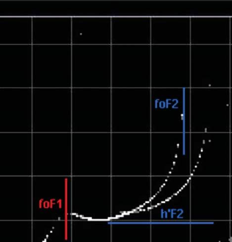
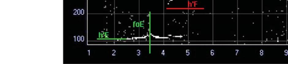
6 The ionogram
7 fof2 The frequency at which a wave just penetrates the ionospheric F2 layer is known as the critical frequency of that layer. The critical frequency is related to the electron density by the simple relation:
8 How to define a climate description of the ionosphere Two basic parameters of the Ionosphere are the NmF2 and the hmf2. ITU R (formerly CCIR) coefficients are used to compute fof2 and M(3000)F2 over the entire globe. They have been derived from monthly medians of fof2 and M(3000)F2 obtained by the worldwide network of ionosondes (about 150 stations) during the years 1954 to 1958 This technique was first developed by Jones and Gallet using only a dependence on latitude and longitude, but soon a dependence on modip was introduced. These coefficients are given for low (R12=0) and high (R12=100) solar activity conditions. For other solar activities conditions simple interpolation is used.
9 Introducing modip A geomagnetic coordinate introduced by Rawer [1963] to be applied in ionospheric studies particularly related to low latitudes: Where I is magnetic inclination or dip at 300 km and is the latitude of the considered location. Modip is near magnetic dip at low latitudes and gets closer to geodetic latitudes at higher latitudes.
10 Modip over Africa
.")
11 The process that dominates the African Ionosphere The physical process that dominates the behavior of the Ionosphere over Africa is the Equatorial Anomaly. Meridional cross-section of the electron density profile at a given time. From Nava et al. (2001). Arrows indicate the limits of continental Africa.

12 A meridional cross section of continental Africa
13 The dominant process as seen by the ionospheric climate Meridional cross-sections (25º E) of NmF2 at four different hours (LT). October 2000 (blue) and 2004 (magenta). Arrows indicate the limits of continental Africa.
14 The dominant process as seen by the ionospheric climate (cont.) Meridional crosssections (25º E) of NmF2 at and (LT). January, July and October for years 2000 (blue) and 2004 (magenta)
15 The dominant process as seen by the ionospheric climate (cont.) Meridional cross-sections (25º E) of hmf2 at four different hours (LT). October 2000 (blue) and 2004 (magenta)
16 Introducing TEC and its variability over Africa: A measure of ionospheric weather

17 Another ionospheric parameter: TEC The total electron content (TEC) is the number of electrons in a column of one metre squared cross section along a trans ionospheric path.
18 Day to day variation of the equatorial anomaly development over Africa
19 Vertical TEC over Africa and its variability Four consecutive days meridional cross sections (25º E) of vertical TEC from global maps at LT.
20 Vertical TEC over Africa and its variability (cont) MMSN = 99 MMSN = 48 GPS derived vertical TEC at 5 min interval for Libreville (Lat. 0.4º N, Long. 9.7º E, modip 24.6º), October 2000 and October Daily values black points, median values red points and quartile values blue points.
21 Quiet and disturbed conditions slant and vertical TEC variations over Africa


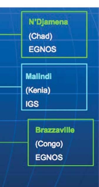
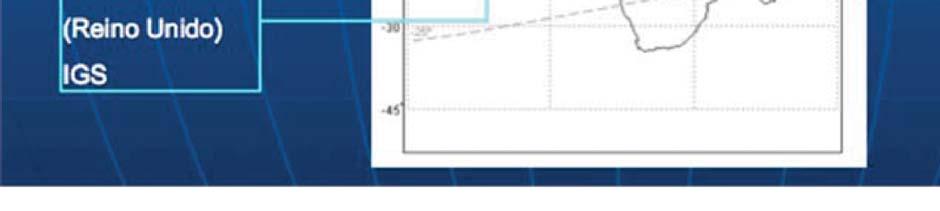
22 Slant and Vertical TEC over Africa and its variability STATIONS USED
23 Introducing geomagnetic activity index DST

24 Dst Index The hourly Dst index is obtained from four magnetic observatories, Hermanus, Kakioka, Honolulu, and San Juan. These observatories were chosen on the basis of the quality of observation and for the reason that their locations are sufficiently distant from the auroral and equatorial electrojets and that they are distributed in longitude as evenly as possible. At such latitudes the H (northward) component of the magnetic perturbation is dominated by the intensity of the magnetospheric ring current. The Dst variation provides a quantitative measure of geomagnetic disturbance that can be correlated with other solar and geophysical parameters. This variation clearly indicates the occurrences of magnetic storms and their severity when they occur.


25 Dst Index and Sunspot number for the periods analyzed: HSA


26 Dst Index and Sunspot number for the periods analyzed (LSA and minimum SA) International Sunspot numbers 2008
27 Middle latitudes conditions


28 Slant and Vertical TEC over Africa and its variability (cont) Six days of slant and vertical GPS derived TEC over Pretoria during quiet geomagnetic conditions and high solar activity (5-10 October 2001)
 Six days of slant and vertical")

29 Slant and Vertical TEC over Africa and its variability (cont) Six days of slant and vertical GPS derived TEC over Pretoria during quiet geomagnetic conditions and low solar activity (20-25 September 2008)


30 Slant and Vertical TEC over Africa and its variability (cont) Six days of slant and vertical GPS derived TEC over Pretoria including disturbed geomagnetic conditions and high solar activity (25-30 October 2001)
31 Conditions under the African southern crest of the equatorial anomaly


32 Slant and Vertical TEC over Africa and its variability (cont) Six days of slant and vertical GPS derived TEC over Mbarara during quiet geomagnetic conditions and high solar activity (5-10 October 2001)


33 Slant and Vertical TEC over Africa and its variability (cont) Six days of slant and vertical GPS derived TEC over Malindi (modip 24.9) during quiet geomagnetic conditions and high solar activity (5-10 October 2001)


34 Slant and Vertical TEC over Africa and its variability (cont) Six days of slant and vertical GPS derived TEC over Mbarara including disturbed d geomagnetic conditions and high h solar activity (25-30 October 2001)
35 Geomagnetic disturbed conditions at middle low latitudes north and south in the African sector
 Six days")


36 Slant and Vertical TEC over Africa and its variability (cont) Six days of slant and vertical GPS derived TEC over Lampedusa (modip 43.9) including disturbed geomagnetic conditions and low solar activity (31 March - 5 April 2004)
37 Slant and Vertical TEC over Africa and its variability (cont) Six days of slant and vertical GPS derived TEC over Richardsbay (modip -48.9) including disturbed geomagnetic conditions and low solar activity (31 March- 5 April 2004)
38 Introducing slant TEC rate of change
39 TEC gradients and TEC rate of change TEC spatial and temporal gradients are features of the ionosphere that lead to errors in navigation and positioning augmented GNSS (SBAS) systems. In most of the conditions found at middle latitudes the effect of gradients is very small under ionospherically quiet conditions. Under disturbed conditions like those that occur during geomagnetic storms, gradients at middle latitudes can reach values that degrade the performance of the systems. At low latitudes both spatial and temporal gradients of TEC are larger and can complicate the operation of SBAS also under nominal conditions due to the dynamics of the development of the equatorial anomaly. Rapid TEC fluctuations associated with the irregularities that develop during the build up of the equatorial anomaly and produce scintillations of the transionospheric propagating signals can also impact on the use of GNSS operations at low latitudes.
40 TEC gradients and TEC rate of change (cont.) When using GPS derived TEC data, the only quantitatively measurable parameter related to the presence of time and spatial (horizontal) gradients is the slant TEC rate of change. At present it does not appears possible to separate the contribution of geometry and gradients from the calculated slant TEC rate of change. The rate of change is measured in TECu/min.
41 TEC gradients and their impact on GNSS operations Global Navigation Satellite Systems operations can be seriously affected in their range accuracy in regions or conditions where large gradients of TEC are found. Space Based Augmentation Systems (SBAS) broadcast equivalent Grid Ionospheric Vertical Delays (GIVD) to correct ionospheric delays. Ionospheric Grid Points (IGP) are given every 5ºx5º. From GIVDs, users interpolate to obtain the equivalent vertical delay at each IPP using interpolation algorithms that work appropriately at middle latitude during nominal quiet conditions where spatial gradients of TEC are small. When gradients are much larger it may be expected that the range delay correction method used by SBAS would not provide adequate ionospheric corrections.
42 TEC gradients and their impact on GNSS operations (cont.) In addition, SBAS operations are based on real time broadcasts of ionospheric corrections that are updated periodically at given time intervals (5 min). Time dependent changes in the ionosphere may degrade or even make obsolete the old broadcast correction before a new one is available to the user. Limits on temporal gradients or rate of change must be determined to protect users from potentially hazardous rates of change that may occur at the users ray path lines of sight.
43 TEC rate of change at a middle latitude location in Africa


")
44 TEC rate of change over Africa Six days of slant TEC rate of change over Pretoria during a geomagnetic quiet period in high solar activity (5-10 October 2001)
 Six days of slant TEC rate of change")

45 TEC rate of change over Africa (cont.) Six days of slant TEC rate of change over Pretoria during a geomagnetic quiet period in high solar activity (20-25 September 2008)
46 TEC rate of change at a location in Africa under the southern crest of the equatorial anomaly


")
47 TEC rate of change over Africa (cont.) Six days of slant TEC rate of change over Mbarara during a geomagnetic quiet period in high solar activity (5-10 October 2001)
 Six days of slant TEC rate of change")

48 TEC rate of change over Africa (cont.) Six days of slant TEC rate of change over Mbarara during a geomagnetic disturbed period in high solar activity (25-30 October 2001)


")
49 TEC rate of change over Africa (cont.) Six days of slant TEC rate of change over Mbarara during a geomagnetic quiet period in minimum solar activity (20-25 September 2008)
50 Electron density depletions or bubbles
51 What they are Electron density depletions or bubbles : regions of the ionosphere where n(x,y,z)/n 0 (x,y,z) < 1 Size: tenth to hundreds of km perpendicular to the geomagnetic field Shape: close to cylindrical with axes along the geomagnetic field ( banana shape ) Dynamics: rise to heights up to1000 km eastward drift ( m/s, lower at higher altitude) branching of do to internal electric field Physical process: F region plasma density irregularities and upward plasma drifts in the equatorial ionosphere that evolve nonlinearly by means of the Rayleigh Taylor instability. Seen in GPS derived TEC data Are related to scintillation occurrence

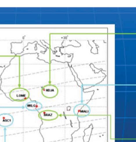
52 African Stations used
53 The method of bubbles detection
54 Examples of bubbles over Africa

55 Bubble occurrence over African stations in 2004
56 Bubble occurrence over African stations in 2004


57 What kind of research can be started with what is already available (past and present data), waiting for more instruments to be installed in the region? The IGS Tracking Network
58 Possible lines of research: objectives To characterize the vertical TEC as a function of modip over Africa, in terms of: Solar activity Seasonal variation Diurnal variation Day to day variability Short term variations (inter hour variability) Differences between station values and values extracted from global maps of vertical TEC for the same location. Effects of geomagnetic activity vs. quiet conditions variability
59 Possible lines of research: objectives (cont.) To characterize bubbles as observed in slant TEC data in terms of: Occurrence Depth Duration Location of the bubble (assuming the bubble at a pierce point) Multiple occurrence from more than one station.
60 Possible lines of research: objectives (cont.) To investigate slant TEC rate of change in terms of: Location (modip) Solar activity Seasonal variation Diurnal variation Day to day variability
61 Acknowledgements Part of this lecture is based on the work carried out by the ICTP ARPL under a contract with the European GNSS Supervisory Authority. The chapter on electron density bubbles was based on a work carried out in collaboration with the Universidad Complutense of Madrid The TEC and TEC rate of change data used in this lecture have been processed by L. Ciraolo.
62 THANK YOU FOR YOUR ATTENTION
Study of the Ionosphere Irregularities Caused by Space Weather Activity on the Base of GNSS Measurements
 Study of the Ionosphere Irregularities Caused by Space Weather Activity on the Base of GNSS Measurements Iu. Cherniak 1, I. Zakharenkova 1,2, A. Krankowski 1 1 Space Radio Research Center,, University
The NeQuick model genesis, uses and evolution
 Vol52,3,2009 20-09-2009 19:06 Pagina 417 ANNALS OF GEOPHYSICS, VOL. 52, N. 3/4, June/August 2009 The NeQuick model genesis, uses and evolution Sandro M. Radicella ARPL, The Abdus Salam ICTP, Trieste, Italy
Plasma effects on transionospheric propagation of radio waves II
 Plasma effects on transionospheric propagation of radio waves II R. Leitinger General remarks Reminder on (transionospheric) wave propagation Reminder of propagation effects GPS as a data source Some electron
Storms in Earth s ionosphere
 Storms in Earth s ionosphere Archana Bhattacharyya Indian Institute of Geomagnetism IISF 2017, WSE Conclave; Anna University, Chennai Earth s Ionosphere Ionosphere is the region of the atmosphere in which
What is Space Weather? THE ACTIVE SUN
 Aardvark Roost AOC Space Weather in Southern Africa Hannes Coetzee 1 What is Space Weather? THE ACTIVE SUN 2 The Violant Sun 3 What is Space Weather? Solar eruptive events (solar flares, coronal Mass Space
ROTI Maps: a new IGS s ionospheric product characterizing the ionospheric irregularities occurrence
 3-7 July 2017 ROTI Maps: a new IGS s ionospheric product characterizing the ionospheric irregularities occurrence Iurii Cherniak Andrzej Krankowski Irina Zakharenkova Space Radio-Diagnostic Research Center,
Impact of the low latitude ionosphere disturbances on GNSS studied with a three-dimensional ionosphere model
 Impact of the low latitude ionosphere disturbances on GNSS studied with a three-dimensional ionosphere model Susumu Saito and Naoki Fujii Communication, Navigation, and Surveillance Department, Electronic
Signature of the 29 March 2006 eclipse on the ionosphere over an equatorial station
 JOURNAL OF GEOPHYSICAL RESEARCH, VOL. 112,, doi:10.1029/2006ja012197, 2007 Signature of the 29 March 2006 eclipse on the ionosphere over an equatorial station J. O. Adeniyi, 1,2 S. M. Radicella, 1 I. A.
Ionospheric Range Error Correction Models
 www.dlr.de Folie 1 >Ionospheric Range Error Correction Models> N. Jakowski and M.M. Hoque 27/06/2012 Ionospheric Range Error Correction Models N. Jakowski and M.M. Hoque Institute of Communications and
EFFECTS OF SCINTILLATIONS IN GNSS OPERATION
 - - EFFECTS OF SCINTILLATIONS IN GNSS OPERATION Y. Béniguel, J-P Adam IEEA, Courbevoie, France - 2 -. Introduction At altitudes above about 8 km, molecular and atomic constituents of the Earth s atmosphere
Activities of the JPL Ionosphere Group
 Activities of the JPL Ionosphere Group On-going GIM wor Submit rapid and final GIM TEC maps for IGS combined ionosphere products FAA WAAS & SBAS analysis Error bounds for Brazilian sector, increasing availability
LEO GPS Measurements to Study the Topside Ionospheric Irregularities
 LEO GPS Measurements to Study the Topside Ionospheric Irregularities Irina Zakharenkova and Elvira Astafyeva 1 Institut de Physique du Globe de Paris, Paris Sorbonne Cité, Univ. Paris Diderot, UMR CNRS
Ionospheric Corrections for GNSS
 Ionospheric Corrections for GNSS The Atmosphere and its Effect on GNSS Systems 14 to 16 April 2008 Santiago, Chile Ing. Roland Lejeune Overview Ionospheric delay corrections Core constellations GPS GALILEO
Analysis of equatorial ionospheric irregularities based on a two high rate GNSS station setup
 Analysis of equatorial ionospheric irregularities based on a two high rate GNSS station setup Jens Berdermann 1,Norbert Jakowski 1, Martin Kriegel 1, Hiroatsu Sato 1, Volker Wilken 1, Stefan Gewies 1,
Assessment of EGNOS performance in worst ionosphere conditions (October and November 2003 storm)
") European Navigation Conference 2005 Munich Assessment of EGNOS performance in worst ionosphere conditions (October and November 2003 storm) Authors: Cristoforo Montefusco 1, Javier Ventura-Traveset 1,
European Navigation Conference 2005 Munich Assessment of EGNOS performance in worst ionosphere conditions (October and November 2003 storm) Authors: Cristoforo Montefusco 1, Javier Ventura-Traveset 1,
Ionospheric Effects on Aviation
 Ionospheric Effects on Aviation Recent experience in the observation and research of ionospheric irregularities, gradient anomalies, depletion walls, etc. in USA and Europe Stan Stankov, René Warnant,
Influence of Major Geomagnetic Storms Occurred in the Year 2011 On TEC Over Bangalore Station In India
 International Journal of Electronics and Communication Engineering. ISSN 0974-2166 Volume 6, Number 1 (2013), pp. 105-110 International Research Publication House http://www.irphouse.com Influence of Major
4 Space plasma effects on Earth-space and satellite-to-satellite communications: Working Group 4 overview
 ANNALS OF GEOPHYSICS, SUPPLEMENT TO VOL. 47, N. 2/3, 2004 4 Space plasma effects on Earth-space and satellite-to-satellite communications: Working Group 4 overview SANDRO M. RADICELLA ( 1 ) and ERSIN TULUNAY
NAVIGATION SYSTEMS PANEL (NSP) NSP Working Group meetings. Impact of ionospheric effects on SBAS L1 operations. Montreal, Canada, October, 2006
 NSP Working Group meetings. Impact of ionospheric effects on SBAS L1 operations. Montreal, Canada, October, 2006") NAVIGATION SYSTEMS PANEL (NSP) NSP Working Group meetings Agenda Item 2b: Impact of ionospheric effects on SBAS L1 operations Montreal, Canada, October, 26 WORKING PAPER CHARACTERISATION OF IONOSPHERE
NAVIGATION SYSTEMS PANEL (NSP) NSP Working Group meetings Agenda Item 2b: Impact of ionospheric effects on SBAS L1 operations Montreal, Canada, October, 26 WORKING PAPER CHARACTERISATION OF IONOSPHERE
The Atmosphere and its Effect on GNSS Systems 14 to 16 April 2008 Santiago, Chile
 Description of a Real-Time Algorithm for Detecting Ionospheric Depletions for SBAS and the Statistics of Depletions in South America During the Peak of the Current Solar Cycle The Atmosphere and its Effect
1. Terrestrial propagation
 Rec. ITU-R P.844-1 1 RECOMMENDATION ITU-R P.844-1 * IONOSPHERIC FACTORS AFFECTING FREQUENCY SHARING IN THE VHF AND UHF BANDS (30 MHz-3 GHz) (Question ITU-R 218/3) (1992-1994) Rec. ITU-R PI.844-1 The ITU
A study of the ionospheric effect on GBAS (Ground-Based Augmentation System) using the nation-wide GPS network data in Japan
 using the nation-wide GPS network data in Japan") A study of the ionospheric effect on GBAS (Ground-Based Augmentation System) using the nation-wide GPS network data in Japan Takayuki Yoshihara, Electronic Navigation Research Institute (ENRI) Naoki Fujii,
A study of the ionospheric effect on GBAS (Ground-Based Augmentation System) using the nation-wide GPS network data in Japan Takayuki Yoshihara, Electronic Navigation Research Institute (ENRI) Naoki Fujii,
Study of small scale plasma irregularities. Đorđe Stevanović
 Study of small scale plasma irregularities in the ionosphere Đorđe Stevanović Overview 1. Global Navigation Satellite Systems 2. Space weather 3. Ionosphere and its effects 4. Case study a. Instruments
Present and future IGS Ionospheric products
 Present and future IGS Ionospheric products Andrzej Krankowski, Manuel Hernández-Pajares, Joachim Feltens, Attila Komjathy, Stefan Schaer, Alberto García-Rigo, Pawel Wielgosz Outline Introduction IGS IONO
Local ionospheric activity - nowcast and forecast services
 Solar Terrestrial Centre of Excellence Ionospheric research and development activities at the Royal of Belgium Local ionospheric activity - nowcast and forecast services S. Stankov, R. Warnant, K. Stegen,
Using GNSS Tracking Networks to Map Global Ionospheric Irregularities and Scintillation
 Using GNSS Tracking Networks to Map Global Ionospheric Irregularities and Scintillation Xiaoqing Pi Anthony J. Mannucci Larry Romans Yaoz Bar-Sever Jet Propulsion Laboratory, California Institute of Technology
Ionogram inversion F1-layer treatment effect in raytracing
 ANNALS OF GEOPHYSICS, VOL. 48, N. 3, June 2005 Ionogram inversion F1-layer treatment effect in raytracing Gloria Miró Amarante ( 1 ), Man-Lian Zhang ( 2 ) and Sandro M. Radicella ( 1 ) ( 1 ) The Abdus
The NeQuick ionosphere electron density model: GNSS applications
 Navigation solutions powered by Europe The NeQuick ionosphere electron density model: GNSS applications B. Nava (1), S.M. Radicella (1), R. Orus (2) (1) ICTP - Trieste, Italy (2) ESTEC/TEC-EEP; ESA - Noordwijk,
Report of Regional Warning Centre INDIA, Annual Report
 Report of Regional Warning Centre INDIA, 2013-2014 Annual Report A.K Upadhayaya Radio and Atmospheric Sciences Division, National Physical Laboratory, New Delhi-110012, India Email: upadhayayaak@nplindia.org
Ionospheric Monitoring in China. Zhen Weimin, Ou Ming
 ICG-5 WG-B, Turino Ionospheric Monitoring in China Zhen Weimin, Ou Ming October 20 th, 2010, Turino, Italy Outline 1.Introduction 2.Ionosphere monitoring in China 3.Summary 1. Introduction GNSS performance
Vertical E B drift velocity variations and associated low-latitude ionospheric irregularities investigated with the TOPEX and GPS satellite data
 Annales Geophysicae (2003) 21: 1017 1030 c European Geosciences Union 2003 Annales Geophysicae Vertical E B drift velocity variations and associated low-latitude ionospheric irregularities investigated
The low latitude ionospheric effects of the April 2000 magnetic storm near the longitude 120 E
 Earth Planets Space, 56, 67 612, 24 The low latitude ionospheric effects of the April 2 magnetic storm near the longitude 12 E Libo Liu 1, Weixing Wan 1,C.C.Lee 2, Baiqi Ning 1, and J. Y. Liu 2 1 Institute
The Effect of Geomagnetic Storm in the Ionosphere using N-h Profiles.
 The Effect of Geomagnetic Storm in the Ionosphere using N-h Profiles. J.C. Morka * ; D.N. Nwachuku; and D.A. Ogwu. Physics Department, College of Education, Agbor, Nigeria E-mail: johnmorka84@gmail.com
Ionospheric sounding at the RMI Geophysical Centre in Dourbes: digital ionosonde performance and ionospheric monitoring service applications
 Solar Terrestrial Centre of Excellence Ionospheric sounding at the RMI Geophysical Centre in Dourbes: digital ionosonde performance and ionospheric monitoring service applications S. Stankov, T. Verhulst,
Special Thanks: M. Magoun, M. Moldwin, E. Zesta, C. Valladares, and AMBER, SCINDA, & C/NOFS teams
 Longitudinal Variability of Equatorial Electrodynamics E. Yizengaw 1, J. Retterer 1, B. Carter 1, K. Groves 1, and R. Caton 2 1 Institute for Scientific Research, Boston College 2 AFRL, Kirtland AFB, NM,
The Significance of GNSS for Radio Science
 Space Weather Effects on the Wide Area Augmentation System (WAAS) The Significance of GNSS for Radio Science Patricia H. Doherty Vice Chair, Commission G International Union of Radio Science www.ursi.org
EFFECTS OF IONOSPHERIC SMALL-SCALE STRUCTURES ON GNSS
 EFFECTS OF IONOSPHERIC SMALL-SCALE STRUCTURES ON GNSS G. Wautelet, S. Lejeune, R. Warnant Royal Meteorological Institute of Belgium, Avenue Circulaire 3 B-8 Brussels (Belgium) e-mail: gilles.wautelet@oma.be
Ionospheric Modeling for WADGPS at Northern Latitudes
 Ionospheric Modeling for WADGPS at Northern Latitudes Peter J. Stewart and Richard B. Langley Geodetic Research Laboratory, Department of Geodesy and Geomatics Engineering, University of New Brunswick,
analysis of GPS total electron content Empirical orthogonal function (EOF) storm response 2016 NEROC Symposium M. Ruohoniemi (3)
 storm response 2016 NEROC Symposium M. Ruohoniemi (3)") Empirical orthogonal function (EOF) analysis of GPS total electron content storm response E. G. Thomas (1), A. J. Coster (2), S.-R. Zhang (2), R. M. McGranaghan (1), S. G. Shepherd (1), J. B. H. Baker
Empirical orthogonal function (EOF) analysis of GPS total electron content storm response E. G. Thomas (1), A. J. Coster (2), S.-R. Zhang (2), R. M. McGranaghan (1), S. G. Shepherd (1), J. B. H. Baker
GNSS IONOSPHERIC SCINTILLATION STUDIES IN SINGAPORE DHIMAS SENTANU MURTI SCHOOL OF ELECTRICAL AND ELECTRONIC ENGINEERING
 GNSS IONOSPHERIC SCINTILLATION STUDIES IN SINGAPORE DHIMAS SENTANU MURTI SCHOOL OF ELECTRICAL AND ELECTRONIC ENGINEERING 2015 GNSS IONOSPHERIC SCINTILLATION STUDIES IN SINGAPORE DHIMAS SENTANU MURTI SCHOOL
RELATIONS BETWEEN THE EQUATORIAL VERTICAL DRIFTS, ELECTROJET, GPS-TEC AND SCINTILLATION DURING THE SOLAR MINIMUM
 RELATIONS BETWEEN THE EQUATORIAL VERTICAL DRIFTS, ELECTROJET, GPS-TEC AND SCINTILLATION DURING THE 2008-09 SOLAR MINIMUM Sovit Khadka 1, 2, Cesar Valladares 2, Rezy Pradipta 2, Edgardo Pacheco 3, and Percy
[EN-107] Impact of the low latitude ionosphere disturbances on GNSS studied with a three-dimensional ionosphere model
![[EN-107] Impact of the low latitude ionosphere disturbances on GNSS studied with a three-dimensional ionosphere model](/thumbs/86/93972301.jpg "[EN-107] Impact of the low latitude ionosphere disturbances on GNSS studied with a three-dimensional ionosphere model") ENRI Int. Workshop on ATM/CNS. Tokyo, Japan (EIWAC21) [EN-17] Impact of the low latitude ionosphere disturbances on GNSS studied with a three-dimensional ionosphere model + S. Saito N. FUjii Communication
ENRI Int. Workshop on ATM/CNS. Tokyo, Japan (EIWAC21) [EN-17] Impact of the low latitude ionosphere disturbances on GNSS studied with a three-dimensional ionosphere model + S. Saito N. FUjii Communication
Scientific Studies of the High-Latitude Ionosphere with the Ionosphere Dynamics and ElectroDynamics - Data Assimilation (IDED-DA) Model
 Model") DISTRIBUTION STATEMENT A. Approved for public release; distribution is unlimited. Scientific Studies of the High-Latitude Ionosphere with the Ionosphere Dynamics and ElectroDynamics - Data Assimilation
DISTRIBUTION STATEMENT A. Approved for public release; distribution is unlimited. Scientific Studies of the High-Latitude Ionosphere with the Ionosphere Dynamics and ElectroDynamics - Data Assimilation
Using NeQuick to reconstruct the 3D Electron Density of the Ionosphere
 Using NeQuick to reconstruct the 3D Electron Density of the Ionosphere Benefits and capabilities in single frequency positioning applications Bruno Nava, Sandro Maria Radicella Telecommunications/ICT for
3-2-9 A Storm-Time Super Bubble as Observed with Dense GPS Receiver Network at East Asian Longitudes
 3-2-9 A Storm-Time Super Bubble as Observed with Dense GPS Receiver Network at East Asian Longitudes A post sunset plasma bubble manifested by TEC depletion was observed at midlatitudes (~30 34 N, ~130
Real-time ionosphere monitoring by three-dimensional tomography over Japan
 Real-time ionosphere monitoring by three-dimensional tomography over Japan 1* Susumu Saito, 2, Shota Suzuki, 2 Mamoru Yamamoto, 3 Chia-Hun Chen, and 4 Akinori Saito 1 Electronic Navigation Research Institute,
On the response of the equatorial and low latitude ionospheric regions in the Indian sector to the large magnetic disturbance of 29 October 2003
 Ann. Geophys., 27, 2539 2544, 2009 Author(s) 2009. This work is distributed under the Creative Commons Attribution 3.0 License. Annales Geophysicae On the response of the equatorial and low latitude ionospheric
Outline. GPS RO Overview. COSMIC Overview. COSMIC-2 Overview. Summary 9/29/16
 Bill Schreiner and UCAR/COSMIC Team UCAR COSMIC Program Observation and Analysis Opportunities Collaborating with the ICON and GOLD Missions Sept 27, 216 GPS RO Overview Outline COSMIC Overview COSMIC-2
MEETING OF THE METEOROLOGY PANEL (METP) METEOROLOGICAL INFORMATION AND SERVICE DEVELOPMENT WORKING GROUP (WG-MISD)
 METEOROLOGICAL INFORMATION AND SERVICE DEVELOPMENT WORKING GROUP (WG-MISD)") METP-WG/MISD/1-IP/09 12/11/15 MEETING OF THE METEOROLOGY PANEL (METP) METEOROLOGICAL INFORMATION AND SERVICE DEVELOPMENT WORKING GROUP (WG-MISD) FIRST MEETING Washington DC, United States, 16 to 19 November
METP-WG/MISD/1-IP/09 12/11/15 MEETING OF THE METEOROLOGY PANEL (METP) METEOROLOGICAL INFORMATION AND SERVICE DEVELOPMENT WORKING GROUP (WG-MISD) FIRST MEETING Washington DC, United States, 16 to 19 November
An Investigation of Local-Scale Spatial Gradient of Ionospheric Delay Using the Nation-Wide GPS Network Data in Japan
 An Investigation of Local-Scale Spatial Gradient of Ionospheric Delay Using the Nation-Wide GPS Network Data in Japan Takayuki Yoshihara, Takeyasu Sakai and Naoki Fujii, Electronic Navigation Research
Global Maps with Contoured Ionosphere Properties Some F-Layer Anomalies Revealed By Marcel H. De Canck, ON5AU. E Layer Critical Frequencies Maps
 Global Maps with Contoured Ionosphere Properties Some F-Layer Anomalies Revealed By Marcel H. De Canck, ON5AU In this column, I shall handle some possibilities given by PROPLAB-PRO to have information
An improved bottomside for the ionospheric electron density model NeQuick
 ANNALS OF GEOPHYSICS, VOL. 48, N. 3, June 2005 An improved bottomside for the ionospheric electron density model NeQuick Reinhart Leitinger ( 1 ), Man-Lian Zhang ( 2 ) and Sandro M. Radicella ( 3 ) ( 1
The Ionosphere and Thermosphere: a Geospace Perspective
 The Ionosphere and Thermosphere: a Geospace Perspective John Foster, MIT Haystack Observatory CEDAR Student Workshop June 24, 2018 North America Introduction My Geospace Background (Who is the Lecturer?
GPS=GLONASS-based TEC measurements as a contributor for space weather forecast
 Journal of Atmospheric and Solar-Terrestrial Physics 64 (2002) 729 735 www.elsevier.com/locate/jastp GPS=GLONASS-based TEC measurements as a contributor for space weather forecast N. Jakowski, S. Heise,
Space Weather influence on satellite based navigation and precise positioning
 Space Weather influence on satellite based navigation and precise positioning R. Warnant, S. Lejeune, M. Bavier Royal Observatory of Belgium Avenue Circulaire, 3 B-1180 Brussels (Belgium) What this talk
The Ionosphere and its Impact on Communications and Navigation. Tim Fuller-Rowell NOAA Space Environment Center and CIRES, University of Colorado
 The Ionosphere and its Impact on Communications and Navigation Tim Fuller-Rowell NOAA Space Environment Center and CIRES, University of Colorado Customers for Ionospheric Information High Frequency (HF)
Detection of Abnormal Ionospheric Activity from the EPN and Impact on Kinematic GPS positioning
 Detection of Abnormal Ionospheric Activity from the EPN and Impact on Kinematic GPS positioning N. Bergeot, C. Bruyninx, E. Pottiaux, S. Pireaux, P. Defraigne, J. Legrand Royal Observatory of Belgium Introduction
Anna Belehaki, Ioanna Tsagouri (NOA, Greece) Ivan Kutiev, Pencho Marinov (BAS, Bulgaria)
 Ivan Kutiev, Pencho Marinov (BAS, Bulgaria)") Characteristics of Large Scale Travelling Ionospheric Disturbances Exploiting Ground-Based Ionograms, GPS-TEC and 3D Electron Density Distribution Maps Anna Belehaki, Ioanna Tsagouri (NOA, Greece) Ivan
Characteristics of Large Scale Travelling Ionospheric Disturbances Exploiting Ground-Based Ionograms, GPS-TEC and 3D Electron Density Distribution Maps Anna Belehaki, Ioanna Tsagouri (NOA, Greece) Ivan
NeQuick model Overview. Y. Migoya Orue, S. M. Radicella, B. Nava, K. Alazo Cuartas and A. Kashcheyev (T/ICT4D) ICTP
 ICTP") NeQuick model Overview Y. Migoya Orue, S. M. Radicella, B. Nava, K. Alazo Cuartas and A. Kashcheyev (T/ICT4D) ICTP United Nations/Argentina Workshop on the Applications of Global Navigation Satellite Systems,
NeQuick model Overview Y. Migoya Orue, S. M. Radicella, B. Nava, K. Alazo Cuartas and A. Kashcheyev (T/ICT4D) ICTP United Nations/Argentina Workshop on the Applications of Global Navigation Satellite Systems,
MWA Ionospheric Science Opportunities Space Weather Storms & Irregularities (location location location) John Foster MIT Haystack Observatory
 John Foster MIT Haystack Observatory") MWA Ionospheric Science Opportunities Space Weather Storms & Irregularities (location location location) John Foster MIT Haystack Observatory Storm Enhanced Density: Longitude-specific Ionospheric Redistribution
MWA Ionospheric Science Opportunities Space Weather Storms & Irregularities (location location location) John Foster MIT Haystack Observatory Storm Enhanced Density: Longitude-specific Ionospheric Redistribution
8 Total electron content A key parameter in propagation: measurement and use in ionospheric imaging
 ANNALS OF GEOPHYSICS, SUPPLEMENT TO VOL. 47, N. 2/3, 2004 8 Total electron content A key parameter in propagation: measurement and use in ionospheric imaging LEONARD KERSLEY ( 1 ), DANIEL MALAN ( 1 ),
Developing systems for ionospheric data assimilation
 Developing systems for ionospheric data assimilation Making a quantitative comparison between observations and models A.C. Bushell, 5 th European Space Weather Week, Brussels, 20 th November 2008 Collaborators
TEC Estimation Using GNSS. Luigi Ciraolo, ICTP. Kigali, July 9th 2014
 TEC Estimation Using GNSS Luigi Ciraolo, ICTP Workshop: African School on Space Science: Related Applications and Awareness for Sustainable Development of the Region Kigali, July 9th 2014 GNSS observables
Study of the ionosphere of Mars: application and limitations of the Chapman-layer model
 Highlights of Spanish Astrophysics VI, Proceedings of the IX Scientific Meeting of the Spanish Astronomical Society held on September 13-17, 2010, in Madrid, Spain. M. R. Zapatero Osorio et al. (eds.)
Hermanus Magnetic Observatory (HMO)
") Hermanus Magnetic Observatory (HMO) As a Space Physics facility in Africa Presented by Danie Gouws & Elda Saunderson The HMO in a nutshell... The Hermanus Magnetic Observatory (HMO) is a national facility
Hermanus Magnetic Observatory (HMO) As a Space Physics facility in Africa Presented by Danie Gouws & Elda Saunderson The HMO in a nutshell... The Hermanus Magnetic Observatory (HMO) is a national facility
DATA AND PRODUCT EXCHANGE IN THE CONTEXT OF WIS. ITU discussions on ionospheric products and formats. (Submitted by the WMO Secretariat)
") WORLD METEOROLOGICAL ORGANIZATION COMMISSION FOR BASIC SYSTEMS COMMISSION FOR AERONAUTICAL METEOROLOGY INTER-PROGRAMME COORDINATION TEAM ON SPACE WEATHER ICTSW-5/Doc. 6.2 (28.X.2014) ITEM: 6.2 FIFTH SESSION
WORLD METEOROLOGICAL ORGANIZATION COMMISSION FOR BASIC SYSTEMS COMMISSION FOR AERONAUTICAL METEOROLOGY INTER-PROGRAMME COORDINATION TEAM ON SPACE WEATHER ICTSW-5/Doc. 6.2 (28.X.2014) ITEM: 6.2 FIFTH SESSION
Ionospheric Radio Occultation Measurements Onboard CHAMP
 Ionospheric Radio Occultation Measurements Onboard CHAMP N. Jakowski 1, K. Tsybulya 1, S. M. Stankov 1, V. Wilken 1, S. Heise 2, A. Wehrenpfennig 3 1 DLR / Institut für Kommunikation und Navigation, Kalkhorstweg
Geomagnetic Indices Forecasting and Ionospheric Nowcasting Tools Work Package 200 INT (Ionosphere Nowcasting Tool) Preliminary considerations.
 Preliminary considerations.") Geomagnetic Indices Forecasting and Ionospheric Nowcasting Tools Work Package 2 INT (Ionosphere Nowcasting Tool) B. Zolesi *, Lj. Cander ** and A. Belehaki *** * Istituto Nazionale di Geofisica e Vulcanologia,
Geomagnetic Indices Forecasting and Ionospheric Nowcasting Tools Work Package 2 INT (Ionosphere Nowcasting Tool) B. Zolesi *, Lj. Cander ** and A. Belehaki *** * Istituto Nazionale di Geofisica e Vulcanologia,
Monitoring the polar cap/ auroral ionosphere: Industrial applications. P. T. Jayachandran Physics Department University of New Brunswick Fredericton
 Monitoring the polar cap/ auroral ionosphere: Industrial applications P. T. Jayachandran Physics Department University of New Brunswick Fredericton Outline Ionosphere and its effects on modern and old
Inversion of Geomagnetic Fields to derive ionospheric currents that drive Geomagnetically Induced Currents.
 Inversion of Geomagnetic Fields to derive ionospheric currents that drive Geomagnetically Induced Currents. J S de Villiers and PJ Cilliers Space Science Directorate South African National Space Agency
Assimilation Ionosphere Model
 Assimilation Ionosphere Model Robert W. Schunk Space Environment Corporation 221 North Spring Creek Parkway, Suite A Providence, UT 84332 phone: (435) 752-6567 fax: (435) 752-6687 email: schunk@spacenv.com
Longitudinal Influence of NmF2 Variability on the Equatorial Ionosphere During High Solar Activity
 Physics Journal Vol. 1, No. 3, 2015, pp. 388-392 http://www.aiscience.org/journal/pj Longitudinal Influence of NmF2 Variability on the Onori E. O. *, Somoye E. O., Ogungbe A. S., Ogwala A. Department of
Data ingestion into NeQuick 2
 RADIO SCIENCE, VOL. 46,, doi:10.1029/2010rs004635, 2011 Data ingestion into NeQuick 2 B. Nava, 1 S. M. Radicella, 1 and F. Azpilicueta 2,3 Received 31 December 2010; revised 2 June 2011; accepted 9 June
GINESTRA MIMOSA - MEDSTEC COMPETENCE SURVEYS WITHIN THE ESA ALCANTARA INITIATIVES
 GINESTRA MIMOSA - MEDSTEC COMPETENCE SURVEYS WITHIN THE ESA ALCANTARA INITIATIVES Lucilla Alfonsi, Gabriella Povero, Julian Rose TENTH EUROPEAN SPACE WEATHER WEEK. Antwerp, 19 th November 2013 WHAT? MImOSA
Spatial and Temporal Variations of GPS-Derived TEC over Malaysia from 2003 to 2009
 Spatial and Temporal Variations of GPS-Derived TEC over Malaysia from 2003 to 2009 Leong, S. K., Musa, T. A. & Abdullah, K. A. UTM-GNSS & Geodynamics Research Group, Infocomm Research Alliance, Faculty
imaging of the ionosphere and its applications to radio propagation Fundamentals of tomographic Ionospheric Tomography I: Ionospheric Tomography I:
 Ionospheric Tomography I: Ionospheric Tomography I: Fundamentals of tomographic imaging of the ionosphere and its applications to radio propagation Summary Introduction to tomography Introduction to tomography
The USU-GAIM Data Assimilation Models for Ionospheric Specifications and Forecasts
 The USU-GAIM Data Assimilation Models for Ionospheric Specifications and Forecasts L. Scherliess, R. W. Schunk, L. C. Gardner, L. Zhu, J.V. Eccles and J.J Sojka Center for Atmospheric and Space Sciences
3D electron density estimation in the ionosphere by using IRI-Plas model and GPS-TEC measurements
 3D electron density estimation in the ionosphere by using IRI-Plas model and GPS-TEC measurements HAKAN TUNA, ORHAN ARIKAN, FEZA ARIKAN Bilkent University, Ankara, Turkey htuna@bilkent.edu.tr, oarikan@ee.bilkent.edu.tr
Daily and seasonal variations of TID parameters over the Antarctic Peninsula
 Daily and seasonal variations of TID parameters over the Antarctic Peninsula A. Zalizovski 1, Y. Yampolski 1, V. Paznukhov 2, E. Mishin 3, A. Sopin 1 1. Institute of Radio Astronomy, National Academy of
Satellite Navigation Science and Technology for Africa. 23 March - 9 April, Scintillation Impacts on GPS
 2025-29 Satellite Navigation Science and Technology for Africa 23 March - 9 April, 2009 Scintillation Impacts on GPS Groves Keith Air Force Research Lab. Hanscom MA 01731 U.S.A. Scintillation Impacts on
Responses of ionospheric fof2 to geomagnetic activities in Hainan
 Advances in Space Research xxx (2007) xxx xxx www.elsevier.com/locate/asr Responses of ionospheric fof2 to geomagnetic activities in Hainan X. Wang a, *, J.K. Shi a, G.J. Wang a, G.A. Zherebtsov b, O.M.
New applications of the portable heater. Gennady Milikh, UMD-SPP group
 New applications of the portable heater Gennady Milikh, UMD-SPP group 1 Stabilization of equatorial spread F (ESF) by ion injection 2 ESF characterizes spreading in the height of F-region backscatter return
Effects of magnetic storms on GPS signals
 Effects of magnetic storms on GPS signals Andreja Sušnik Supervisor: doc.dr. Biagio Forte Outline 1. Background - GPS system - Ionosphere 2. Ionospheric Scintillations 3. Experimental data 4. Conclusions
Imaging of the equatorial ionosphere
 ANNALS OF GEOPHYSICS, VOL. 48, N. 3, June 2005 Imaging of the equatorial ionosphere Massimo Materassi ( 1 ) and Cathryn N. Mitchell ( 2 ) ( 1 ) Istituto dei Sistemi Complessi, CNR, Sesto Fiorentino (FI),
Chapter 2 Analysis of Polar Ionospheric Scintillation Characteristics Based on GPS Data
 Chapter 2 Analysis of Polar Ionospheric Scintillation Characteristics Based on GPS Data Lijing Pan and Ping Yin Abstract Ionospheric scintillation is one of the important factors that affect the performance
Variations of f o F 2 and GPS total electron content over the Antarctic sector
 Earth Planets Space, 63, 327 333, 2011 Variations of f o F 2 and GPS total electron content over the Antarctic sector M. Mosert 1, L. A. McKinnell 2,3, M. Gende 4, C. Brunini 4, J. Araujo 5, R. G. Ezquer
Variability of ionospheric scintillation near the equatorial anomaly crest of the Indian zone
 EGU Journal Logos (RGB) doi:10.5194/angeo-31-697-2013 Author(s) 2013. CC Attribution 3.0 License. Advances in Geosciences Annales Geophysicae N Natural Hazards and Earth System Sciences Atmospheric Chemistry
Validation of new ionospheric parameter modeling
 Validation of new ionospheric parameter modeling MALTSEVA OLGA, ZHBANKOV GENNAGIJ Institute for Physics Southern Federal University Stachki, 194, Roston-on-Don RUSSIA mai@ip.rsu.ru Abstract: - The growing
Assimilation Ionosphere Model
 Assimilation Ionosphere Model Robert W. Schunk Space Environment Corporation 399 North Main, Suite 325 Logan, UT 84321 phone: (435) 752-6567 fax: (435) 752-6687 email: schunk@spacenv.com Award #: N00014-98-C-0085
Three-dimensional and numerical ray tracing on a phenomenological ionospheric model
 Three-dimensional and numerical ray tracing on a phenomenological ionospheric model Lung-Chih Tsai 1, 2, C. H. Liu 3, T. Y. Hsiao 4, and J. Y. Huang 1 (1) Center for Space and Remote Sensing research,
Measuring Total Electron Content. Investigation of Two Different Techniques
 Measuring Total Electron Content with GNSS: Investigation of Two Different Techniques Benoît Bidaine 1 F.R.S. FNRS B.Bidaine@ulg.ac.be Prof. René Warnant 1,2 R.Warnant@oma.be 1 University of Liège (Unit
Data Assimilation into Ionospheric Models
 Data Assimilation into Ionospheric Models Bruno Nava Karl Franzens University Graz, Graz, Austria ICTP, Trieste, Italy Supervisor: Prof. H. Biernat Karl Franzens University Graz, Graz, Austria Advisor:
Recent progress of NICT ionospheric observations in Japan
 Recent progress of NICT ionospheric observations in Japan T. Tsugawa, M. Nishioka, H. Kato, H. Jin, and M. Ishii National Institute of Information and Communications Technology (NICT), Japan NICT ionospheric
Weathering the Storm GNSS and the Solar Maximum Next Generation GNSS Ionospheric Scintillation and TEC Monitoring
 Weathering the Storm GNSS and the Solar Maximum Next Generation GNSS Ionospheric Scintillation and TEC Monitoring NovAtel White Paper March 2012 Overview This paper addresses the concerns caused by the
Radio tomography based on satellite beacon experiment and FORMOSAT- 3/COSMIC radio occultation
 Radio tomography based on satellite beacon experiment and FORMOSAT- 3/COSMIC radio occultation Mamoru Yamamoto (1), Smitha V. Thampi (2), Charles Lin (3) (1) RISH, Kyoto University, Japan (2) Space Physics
Low latitude ionospheric effects of major geomagnetic storms observed using TOPEX TEC data
 Ann. Geophys., 27, 3133 3139, 2009 Author(s) 2009. This work is distributed under the Creative Commons Attribution 3.0 License. Annales Geophysicae Low latitude ionospheric effects of major geomagnetic
JOURNAL OF GEOPHYSICAL RESEARCH, VOL. 115, A03301, doi: /2009ja014788, 2010
 Click Here for Full Article JOURNAL OF GEOPHYSICAL RESEARCH, VOL. 115,, doi:10.1029/2009ja014788, 2010 Scintillation producing Fresnel scale irregularities associated with the regions of steepest TEC gradients
Using the GRAIT Detrender to Study Ionospheric Bubbles / Irregularities over South America and the Caribbean
 Using the GRAIT Detrender to Study Ionospheric Bubbles / Irregularities over South America and the Caribbean (and the prospect for Southeast Asia-Pacific) Rezy Pradipta Boston College Institute for Scientific
Second Workshop on Satellite Navigation Science and Technology for Africa April 2010
 2135-6 Second Workshop on Satellite Navigation Science and Technology for Africa 6-23 April 2010 Update on SCINDA Activities in Africa and Around the Globe R. Caton AFRL Hansom USA An Update on SCINDA
The ICG, Multifunction GNSS Signals and How To Protect Them. Space Weather Studies Using GNSS and Space Science Outreach activities at Sangli
 4 th EUROPEAN SPACE SOLUTIONS The ICG, Multifunction GNSS Signals and How To Protect Them Space Weather Studies Using GNSS and Space Science Outreach activities at Sangli D. J. SHETTI DEPARTMENT OF PHYSICS,