Effects of magnetic storms on GPS signals
|
|
|
- Juliet Hunt
- 6 years ago
- Views:
Transcription
1 Effects of magnetic storms on GPS signals Andreja Sušnik Supervisor: doc.dr. Biagio Forte
2 Outline 1. Background - GPS system - Ionosphere 2. Ionospheric Scintillations 3. Experimental data 4. Conclusions
3 The GPS system? stands for Global Positioning System, is a U.S. space-based radio-navigation system that provides reliable positioning, navigation, and timing services to civil users on a continuous worldwide basis. The GPS system consist of three segments: - Space segment - Control segment - User segment

4 The GPS system Space segment - 24 to 36 satellites - in six orbital planes - at altitude 20,183 km

5 The GPS system Control segment


6 The GPS system User segment Applications: - navigation - geodesy - timing - surveying - surveillance - aviation - agriculture - cadastre

7 The GPS system - each GPS satellite transmits continuously using two radio frequencies in the L-band: L1 : GHz L2 : GHz Signal structure: - Carrier - Ranging code (pseudorandom codes, PRN) - Navigation data
")
8 The GPS system Signal Structure: Carrier Ranging code (pseudo-random codes, PRN) Navigation data

9 How does it work?

10 Error Sources Troposphere 1 orbit error = ± 2.5 meters 2 clock error = ± 2 meters 3 Ionospheric Delay = ± 5 meters 4 Tropospheric Delay = ± 0.5 meters 5 Multipath = ± 1 meters 6 Receiver noise = ± 1 meters
11 Ionospheric Delay - Group Delay - Phase Advance - Doppler Shift - Faraday Rotation - Ray-path bending - Random fluctuations, in both intensity and phase Total electron content = TEC Ionospheric scintillations TEC units 1 TECU = electrons/m 2
12 Ionosphere - it is the upper part of the Earth s atmosphere that is ionized by solar radiation - it extends from about 75 to 1000 km and completely encircles the Earth Vertical structure of the Earth atmosphere Public domain image from WikiMedia Commons
13 Ionosphere The ionosphere is composed of three main layers: the D, E, and F regions: - F-region: km contains a range of ions from NO + and O + at the bottom to H + and He + ions at the top. Electron density reaches an absolute maximum in this region, - E-region: km, contains mostly O 2 + and NO 2 + ions, with metallic long lived ions to a minor extent, - D-region: 75-95km up, relatively weak ionization due to its position at the bottom. Ionospheric layers and the corresponding electron densities
14 1. Background - GPS system - Ionosphere 1. Ionospheric Scintillations 2. Experimental data 3. Conclusions
15 Ionospheric Scintillations - GPS signal traversing Earth s atmosphere suffers distortion of phase and amplitude. - When it traverses small-scale ionospheric plasma-density irregularities, fading, phase fluctuations, and angle of arrival variations are experienced at the receivers IONOSPHERIC SCINTILLATION - varies widely with transmission frequency, magnetic and solar activity, season, and latitude
, during low and moderate solar activity (Aarons and")
16 Ionospheric Scintillations (1) high latitude region the equatorial region middle latitudes middle latitudes high latitude region Global depth of scintillation fading (proportional to density of crosshatching), during low and moderate solar activity (Aarons and Basu, 85)

17 Ionospheric Scintillations (2) Pattern of ionospheric scintillation during solar maximum and solar minimum (Basu et al., 1988).
18 Ionospheric Scintillations (2) - scintillation of the GPS signals is a consequence of the existence of spatial electron-density fluctuations within the ionosphere z = 0 (0,0,z) L z L = irregularity slab receiver
19 Ionospheric Scintillations (3) - as the wave propagates through the irregularity slab, only the phase is affected by the random fluctuations in refractive index = is the free-space wavenumber, in the layer with irregularities. = is the variation of the optical path length within the layer with irregularities.
20 Ionospheric Scintillations (4) - as the wave propagates toward the receiver, further phase mixing occurs, changing the modulation of the wave L z (0,0,z) receiver
21 Ionospheric Scintillations (5) Assumption: - the temporal variations of the irregularities are much slower than the wave period - the characteristic size of irregularities is much greater than the wavelength PHASE SCREEN in which the irregular layer is replaced by a screen, changing only the wave s phase.
22 Ionospheric Scintillations (6) Scintillation activity - typically is measured by means of several indices: S 4 index the phase scintillation index = indicates ensemble averages = received intensity
23 Ionospheric Scintillations (7) SI index I 0 t
24 1. Background - GPS system - Ionosphere 2. Ionospheric Scintillations 3. Experimental data 4. Conclusions
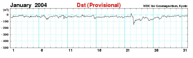
 - three magnetic storm events are considered, including quiet days prior the storm, main storm phases and recovery phases: from 6.12.2004 to 8.12.2004 from 23.1.2004 to 30.1.2004 from 8.1.2005 to 9.")
25 Experimental data (1) - GPS scintillation monitor at the Dirigibile Italia Station (Ny Alesund, Svalbard) - the monitor is dual frequency GPS receiver able to record 50 Hz raw data (intensity and phase) - three magnetic storm events are considered, including quiet days prior the storm, main storm phases and recovery phases: from to from to from to
26

27 Kp index for the day

28 Kp index for the day
29 Experimental data (2) - raw signal intensity and phase are detrended with a 6 th order Butterworth high-pass filter, in order to remove undesired effects from the signals dynamics. - three different values of the filter low frequency cutoff have been used: 0.1 Hz blue 0.3 Hz green 0.5 Hz red
30 Results UT on the day , PRN 28
31 Results UT on the day , PRN 28
32 Results UT on the day ,PRN 28
33 Results UT on the day , PRN 28
34 Results UT on the day ,PRN 3
35 Results UT on the day ,PRN 3
36 Results UT on the day ,PRN 3
37 Results UT on the day ,PRN 3
38 Conclusions - an erroneous data detrending can be responsible for misleading data interpretation - the new indices so far suggested show a better description of the events analyzed in terms of the measured scintillation activity - more analyses will be done in the future on datasets from the African and Brazilian low latitudes sectors - more experimental data at middle latitudes during solar maximum will be recorded at the UNG atmospheric observatory (Otlica) - more experimental information at middle latitudes will be carried out by a TEC polarimeter to be implemented at the Otlica observatory later this year.
39 Thank you!
Study of small scale plasma irregularities. Đorđe Stevanović
 Study of small scale plasma irregularities in the ionosphere Đorđe Stevanović Overview 1. Global Navigation Satellite Systems 2. Space weather 3. Ionosphere and its effects 4. Case study a. Instruments
Space Weather and the Ionosphere
 Dynamic Positioning Conference October 17-18, 2000 Sensors Space Weather and the Ionosphere Grant Marshall Trimble Navigation, Inc. Note: Use the Page Down key to view this presentation correctly Space
ESTIMATION OF IONOSPHERIC DELAY FOR SINGLE AND DUAL FREQUENCY GPS RECEIVERS: A COMPARISON
 ESTMATON OF ONOSPHERC DELAY FOR SNGLE AND DUAL FREQUENCY GPS RECEVERS: A COMPARSON K. Durga Rao, Dr. V B S Srilatha ndira Dutt Dept. of ECE, GTAM UNVERSTY Abstract: Global Positioning System is the emerging
ROTI Maps: a new IGS s ionospheric product characterizing the ionospheric irregularities occurrence
 3-7 July 2017 ROTI Maps: a new IGS s ionospheric product characterizing the ionospheric irregularities occurrence Iurii Cherniak Andrzej Krankowski Irina Zakharenkova Space Radio-Diagnostic Research Center,
NAVIGATION SYSTEMS PANEL (NSP) NSP Working Group meetings. Impact of ionospheric effects on SBAS L1 operations. Montreal, Canada, October, 2006
 NSP Working Group meetings. Impact of ionospheric effects on SBAS L1 operations. Montreal, Canada, October, 2006") NAVIGATION SYSTEMS PANEL (NSP) NSP Working Group meetings Agenda Item 2b: Impact of ionospheric effects on SBAS L1 operations Montreal, Canada, October, 26 WORKING PAPER CHARACTERISATION OF IONOSPHERE
NAVIGATION SYSTEMS PANEL (NSP) NSP Working Group meetings Agenda Item 2b: Impact of ionospheric effects on SBAS L1 operations Montreal, Canada, October, 26 WORKING PAPER CHARACTERISATION OF IONOSPHERE
Chapter 2 Analysis of Polar Ionospheric Scintillation Characteristics Based on GPS Data
 Chapter 2 Analysis of Polar Ionospheric Scintillation Characteristics Based on GPS Data Lijing Pan and Ping Yin Abstract Ionospheric scintillation is one of the important factors that affect the performance
Propagation for Space Applications
 Propagation for Space Applications by Bertram Arbesser-Rastburg Chairman ITU-R SG3 Invited talk at LAPC 2014, Loughborough, UK bertram@arbesser.org Abstract:The presentation covers the key propagation
A study of the ionospheric effect on GBAS (Ground-Based Augmentation System) using the nation-wide GPS network data in Japan
 using the nation-wide GPS network data in Japan") A study of the ionospheric effect on GBAS (Ground-Based Augmentation System) using the nation-wide GPS network data in Japan Takayuki Yoshihara, Electronic Navigation Research Institute (ENRI) Naoki Fujii,
A study of the ionospheric effect on GBAS (Ground-Based Augmentation System) using the nation-wide GPS network data in Japan Takayuki Yoshihara, Electronic Navigation Research Institute (ENRI) Naoki Fujii,
Operational Products of the Space Weather Application Center Ionosphere (SWACI) and capabilities of their use
 and capabilities of their use") Operational Products of the Space Weather Application Center Ionosphere (SWACI) and capabilities of their use N. Jakowski, C. Borries, V. Wilken, K.D. Missling, H. Barkmann, M. M. Hoque, M. Tegler, C.
Operational Products of the Space Weather Application Center Ionosphere (SWACI) and capabilities of their use N. Jakowski, C. Borries, V. Wilken, K.D. Missling, H. Barkmann, M. M. Hoque, M. Tegler, C.
1. Terrestrial propagation
 Rec. ITU-R P.844-1 1 RECOMMENDATION ITU-R P.844-1 * IONOSPHERIC FACTORS AFFECTING FREQUENCY SHARING IN THE VHF AND UHF BANDS (30 MHz-3 GHz) (Question ITU-R 218/3) (1992-1994) Rec. ITU-R PI.844-1 The ITU
The Significance of GNSS for Radio Science
 Space Weather Effects on the Wide Area Augmentation System (WAAS) The Significance of GNSS for Radio Science Patricia H. Doherty Vice Chair, Commission G International Union of Radio Science www.ursi.org
The Role of Ground-Based Observations in M-I I Coupling Research. John Foster MIT Haystack Observatory
 The Role of Ground-Based Observations in M-I I Coupling Research John Foster MIT Haystack Observatory CEDAR/GEM Student Workshop Outline Some Definitions: Magnetosphere, etc. Space Weather Ionospheric
Storms in Earth s ionosphere
 Storms in Earth s ionosphere Archana Bhattacharyya Indian Institute of Geomagnetism IISF 2017, WSE Conclave; Anna University, Chennai Earth s Ionosphere Ionosphere is the region of the atmosphere in which
Antennas and Propagation
 CMPE 477 Wireless and Mobile Networks Lecture 3: Antennas and Propagation Antennas Propagation Modes Line of Sight Transmission Fading in the Mobile Environment Introduction An antenna is an electrical
Study of GPS Scintillation during Solar Maximum at Malaysia
 1 st International Conference of Recent Trends in Information and Communication Technologies Study of GPS Scintillation during Solar Maximum at Malaysia Emad Fathi Aon 1,2*, Redhwan Qasem Shaddad 3,4,Abdul
Radio Astronomy and the Ionosphere
 Radio Astronomy and the Ionosphere John A Kennewell, Mike Terkildsen CAASTRO EoR Global Signal Workshop November 2012 THE IONOSPHERE UPPER ATMOSPHERIC PLASMA - The ionosphere is a weak (1%) variable plasma
CDAAC Ionospheric Products
 CDAAC Ionospheric Products Stig Syndergaard COSMIC Project Office COSMIC retreat, Oct 13 14, 5 COSMIC Ionospheric Measurements GPS receiver: { Total Electron Content (TEC) to all GPS satellites in view
Monitoring the polar cap/ auroral ionosphere: Industrial applications. P. T. Jayachandran Physics Department University of New Brunswick Fredericton
 Monitoring the polar cap/ auroral ionosphere: Industrial applications P. T. Jayachandran Physics Department University of New Brunswick Fredericton Outline Ionosphere and its effects on modern and old
It is common knowledge in the
 Do modern multi-frequency civil receivers eliminate the ionospheric effect? GNSS Solutions is a regular column featuring questions and answers about technical aspects of GNSS. Readers are invited to send
Study of the Ionosphere Irregularities Caused by Space Weather Activity on the Base of GNSS Measurements
 Study of the Ionosphere Irregularities Caused by Space Weather Activity on the Base of GNSS Measurements Iu. Cherniak 1, I. Zakharenkova 1,2, A. Krankowski 1 1 Space Radio Research Center,, University
EFFECTS OF SCINTILLATIONS IN GNSS OPERATION
 - - EFFECTS OF SCINTILLATIONS IN GNSS OPERATION Y. Béniguel, J-P Adam IEEA, Courbevoie, France - 2 -. Introduction At altitudes above about 8 km, molecular and atomic constituents of the Earth s atmosphere
Simulation Results of Alternative Methods for Formation Separation Control
 Simulation Results of Alternative Methods for Formation Separation Control Thomas Heine, Charles Bussy-Virat, Mark Moldwin, Aaron Ridley Department of Climate and Space Sciences and Engineering University
Regional ionospheric disturbances during magnetic storms. John Foster
 Regional ionospheric disturbances during magnetic storms John Foster Regional Ionospheric Disturbances John Foster MIT Haystack Observatory Regional Disturbances Meso-Scale (1000s km) Storm Enhanced Density
Use of GNSS Radio Occultation data for Climate Applications Bill Schreiner Sergey Sokolovskiy, Doug Hunt, Ben Ho, Bill Kuo UCAR
 Use of GNSS Radio Occultation data for Climate Applications Bill Schreiner (schrein@ucar.edu), Sergey Sokolovskiy, Doug Hunt, Ben Ho, Bill Kuo UCAR COSMIC Program Office www.cosmic.ucar.edu 1 Questions
Total Electron Content (TEC) and Model Validation at an Equatorial Region
 and Model Validation at an Equatorial Region") Total Electron Content (TEC) and Model Validation at an Equatorial Region NORSUZILA YA ACOB 1, MARDINA ABDULLAH 2,* MAHAMOD ISMAIL 2,* AND AZAMI ZAHARIM 3,** 1 Faculty of Electrical Engineering, Universiti
Total Electron Content (TEC) and Model Validation at an Equatorial Region NORSUZILA YA ACOB 1, MARDINA ABDULLAH 2,* MAHAMOD ISMAIL 2,* AND AZAMI ZAHARIM 3,** 1 Faculty of Electrical Engineering, Universiti
DYNAMIC POSITIONING CONFERENCE October 17 18, 2000 SENSORS. Space Weather and the Ionosphere. Grant Marshall Trimble Navigation Inc.
 DYNAMIC POSIIONING CONFERENCE October 17 18, 2000 SENSORS Space Weather and the Ionosphere Grant Marshall rimble Navigation Inc. Images shown here are part of an animated presentation and may not appear
Space Weather influence on satellite based navigation and precise positioning
 Space Weather influence on satellite based navigation and precise positioning R. Warnant, S. Lejeune, M. Bavier Royal Observatory of Belgium Avenue Circulaire, 3 B-1180 Brussels (Belgium) What this talk
Monitoring the Ionosphere and Neutral Atmosphere with GPS
 Monitoring the Ionosphere and Neutral Atmosphere with GPS Richard B. Langley Geodetic Research Laboratory Department of Geodesy and Geomatics Engineering University of New Brunswick Fredericton, N.B. Division
Global Positioning System: what it is and how we use it for measuring the earth s movement. May 5, 2009
 Global Positioning System: what it is and how we use it for measuring the earth s movement. May 5, 2009 References Lectures from K. Larson s Introduction to GNSS http://www.colorado.edu/engineering/asen/
Antennas and Propagation
 Antennas and Propagation Chapter 5 Introduction An antenna is an electrical conductor or system of conductors Transmission - radiates electromagnetic energy into space Reception - collects electromagnetic
Ionospheric Range Error Correction Models
 www.dlr.de Folie 1 >Ionospheric Range Error Correction Models> N. Jakowski and M.M. Hoque 27/06/2012 Ionospheric Range Error Correction Models N. Jakowski and M.M. Hoque Institute of Communications and
Chapter 15: Radio-Wave Propagation
 Chapter 15: Radio-Wave Propagation MULTIPLE CHOICE 1. Radio waves were first predicted mathematically by: a. Armstrong c. Maxwell b. Hertz d. Marconi 2. Radio waves were first demonstrated experimentally
Impact of the low latitude ionosphere disturbances on GNSS studied with a three-dimensional ionosphere model
 Impact of the low latitude ionosphere disturbances on GNSS studied with a three-dimensional ionosphere model Susumu Saito and Naoki Fujii Communication, Navigation, and Surveillance Department, Electronic
The impact of geomagnetic substorms on GPS receiver performance
 LETTER Earth Planets Space, 52, 1067 1071, 2000 The impact of geomagnetic substorms on GPS receiver performance S. Skone and M. de Jong Department of Geomatics Engineering, University of Calgary, 2500
Rec. ITU-R P RECOMMENDATION ITU-R P *
 Rec. ITU-R P.682-1 1 RECOMMENDATION ITU-R P.682-1 * PROPAGATION DATA REQUIRED FOR THE DESIGN OF EARTH-SPACE AERONAUTICAL MOBILE TELECOMMUNICATION SYSTEMS (Question ITU-R 207/3) Rec. 682-1 (1990-1992) The
GNSS IONOSPHERIC SCINTILLATION STUDIES IN SINGAPORE DHIMAS SENTANU MURTI SCHOOL OF ELECTRICAL AND ELECTRONIC ENGINEERING
 GNSS IONOSPHERIC SCINTILLATION STUDIES IN SINGAPORE DHIMAS SENTANU MURTI SCHOOL OF ELECTRICAL AND ELECTRONIC ENGINEERING 2015 GNSS IONOSPHERIC SCINTILLATION STUDIES IN SINGAPORE DHIMAS SENTANU MURTI SCHOOL
Modelling GPS Observables for Time Transfer
 Modelling GPS Observables for Time Transfer Marek Ziebart Department of Geomatic Engineering University College London Presentation structure Overview of GPS Time frames in GPS Introduction to GPS observables
Broadcast Ionospheric Model Accuracy and the Effect of Neglecting Ionospheric Effects on C/A Code Measurements on a 500 km Baseline
 Broadcast Ionospheric Model Accuracy and the Effect of Neglecting Ionospheric Effects on C/A Code Measurements on a 500 km Baseline Intro By David MacDonald Waypoint Consulting May 2002 The ionosphere
Ionospheric Propagation
 Ionospheric Nick Massey VA7NRM 1 Electromagnetic Spectrum Radio Waves are a form of Electromagnetic Radiation Visible Light is also a form of Electromagnetic Radiation Radio Waves behave a lot like light
Comparative analysis of the effect of ionospheric delay on user position accuracy using single and dual frequency GPS receivers over Indian region
 Indian Journal of Radio & Space Physics Vol. 38, February 2009, pp. 57-61 Comparative analysis of the effect of ionospheric delay on user position accuracy using single and dual frequency GPS receivers
Estimation Method of Ionospheric TEC Distribution using Single Frequency Measurements of GPS Signals
 Estimation Method of Ionospheric TEC Distribution using Single Frequency Measurements of GPS Signals Win Zaw Hein #, Yoshitaka Goto #, Yoshiya Kasahara # # Division of Electrical Engineering and Computer
Assessment of GNSS Ionospheric Scintillation and TEC Monitoring Using the Multi-constellation GPStation-6 Receiver
 Assessment of GNSS Ionospheric Scintillation and TEC Monitoring Using the Multi-constellation GPStation-6 Receiver Rod MacLeod Regional Manager Asia/Pacific NovAtel Australia Pty Ltd Outline Ionospheric
Ionospheric Modeling for WADGPS at Northern Latitudes
 Ionospheric Modeling for WADGPS at Northern Latitudes Peter J. Stewart and Richard B. Langley Geodetic Research Laboratory, Department of Geodesy and Geomatics Engineering, University of New Brunswick,
The Ionosphere and Thermosphere: a Geospace Perspective
 The Ionosphere and Thermosphere: a Geospace Perspective John Foster, MIT Haystack Observatory CEDAR Student Workshop June 24, 2018 North America Introduction My Geospace Background (Who is the Lecturer?
Influence of Major Geomagnetic Storms Occurred in the Year 2011 On TEC Over Bangalore Station In India
 International Journal of Electronics and Communication Engineering. ISSN 0974-2166 Volume 6, Number 1 (2013), pp. 105-110 International Research Publication House http://www.irphouse.com Influence of Major
Antennas and Propagation. Chapter 5
 Antennas and Propagation Chapter 5 Introduction An antenna is an electrical conductor or system of conductors Transmission - radiates electromagnetic energy into space Reception - collects electromagnetic
UNIT 1 - introduction to GPS
 UNIT 1 - introduction to GPS 1. GPS SIGNAL Each GPS satellite transmit two signal for positioning purposes: L1 signal (carrier frequency of 1,575.42 MHz). Modulated onto the L1 carrier are two pseudorandom
Investigation of Scintillation Characteristics for High Latitude Phenomena
 Investigation of Scintillation Characteristics for High Latitude Phenomena S. Skone, F. Man, F. Ghafoori and R. Tiwari Department of Geomatics Engineering, Schulich School of Engineering, University of
Detection of Abnormal Ionospheric Activity from the EPN and Impact on Kinematic GPS positioning
 Detection of Abnormal Ionospheric Activity from the EPN and Impact on Kinematic GPS positioning N. Bergeot, C. Bruyninx, E. Pottiaux, S. Pireaux, P. Defraigne, J. Legrand Royal Observatory of Belgium Introduction
EFFECTS OF IONOSPHERIC SMALL-SCALE STRUCTURES ON GNSS
 EFFECTS OF IONOSPHERIC SMALL-SCALE STRUCTURES ON GNSS G. Wautelet, S. Lejeune, R. Warnant Royal Meteorological Institute of Belgium, Avenue Circulaire 3 B-8 Brussels (Belgium) e-mail: gilles.wautelet@oma.be
Ionospheric propagation data and prediction methods required for the design of satellite services and systems. Recommendation ITU-R P.
 Recommendation ITU-R P.31-13 (09/016) Ionospheric propagation data and prediction methods required for the design of satellite services and systems P Series Radiowave propagation ii Rec. ITU-R P.31-13
Antennas and Propagation. Chapter 5
 Antennas and Propagation Chapter 5 Introduction An antenna is an electrical conductor or system of conductors Transmission - radiates electromagnetic energy into space Reception - collects electromagnetic
Reading 28 PROPAGATION THE IONOSPHERE
 Reading 28 Ron Bertrand VK2DQ http://www.radioelectronicschool.com PROPAGATION THE IONOSPHERE The ionosphere is a region of the upper atmosphere extending from a height of about 60 km to greater than 500
IONOSPHERE EFFECTS ON GPS/RF COMMUNICATION, ELECTRIC, METAL NETWORKS AND SPACECRAFTS OSMAN AKGÜN
 IONOSPHERE EFFECTS ON GPS/RF COMMUNICATION, ELECTRIC, METAL NETWORKS AND SPACECRAFTS 2119212 OSMAN AKGÜN IONOSPHERE IONOSPHERE EFFECTS POSSIBLE EFFECTS GPS errors Atomic oxygen attack Spacecraft charging
James M Anderson. in collaboration with Jan Noordam and Oleg Smirnov. MPIfR, Bonn, 2006 Dec 07
 Ionospheric Calibration for Long-Baseline, Low-Frequency Interferometry in collaboration with Jan Noordam and Oleg Smirnov Page 1/36 Outline The challenge for radioastronomy Introduction to the ionosphere
Plasma effects on transionospheric propagation of radio waves II
 Plasma effects on transionospheric propagation of radio waves II R. Leitinger General remarks Reminder on (transionospheric) wave propagation Reminder of propagation effects GPS as a data source Some electron
Project = An Adventure : Wireless Networks. Lecture 4: More Physical Layer. What is an Antenna? Outline. Page 1
 Project = An Adventure 18-759: Wireless Networks Checkpoint 2 Checkpoint 1 Lecture 4: More Physical Layer You are here Done! Peter Steenkiste Departments of Computer Science and Electrical and Computer
LEO GPS Measurements to Study the Topside Ionospheric Irregularities
 LEO GPS Measurements to Study the Topside Ionospheric Irregularities Irina Zakharenkova and Elvira Astafyeva 1 Institut de Physique du Globe de Paris, Paris Sorbonne Cité, Univ. Paris Diderot, UMR CNRS
Ionospheric Impacts on UHF Space Surveillance. James C. Jones Darvy Ceron-Gomez Dr. Gregory P. Richards Northrop Grumman
 Ionospheric Impacts on UHF Space Surveillance James C. Jones Darvy Ceron-Gomez Dr. Gregory P. Richards Northrop Grumman CONFERENCE PAPER Earth s atmosphere contains regions of ionized plasma caused by
Monitoring the Auroral Oval with GPS and Applications to WAAS
 Monitoring the Auroral Oval with GPS and Applications to WAAS Peter J. Stewart and Richard B. Langley Geodetic Research Laboratory Department of Geodesy and Geomatics Engineering University of New Brunswick
Satellite Navigation Science and Technology for Africa. 23 March - 9 April, Scintillation Impacts on GPS
 2025-29 Satellite Navigation Science and Technology for Africa 23 March - 9 April, 2009 Scintillation Impacts on GPS Groves Keith Air Force Research Lab. Hanscom MA 01731 U.S.A. Scintillation Impacts on
Observation of Scintillation Events from GPS and NavIC (IRNSS) Measurements at Bangalore Region
 Measurements at Bangalore Region") Observation of Scintillation Events from GPS and NavIC (IRNSS) Measurements at Bangalore Region Manjula T R 1, Raju Garudachar 2 Department of Electronics and communication SET, Jain University, Bangalore
Observation of Scintillation Events from GPS and NavIC (IRNSS) Measurements at Bangalore Region Manjula T R 1, Raju Garudachar 2 Department of Electronics and communication SET, Jain University, Bangalore
Ionospheric Propagation Effects on W de Bandwidth Sig Si nals Dennis L. Knepp NorthWest Research NorthW Associates est Research Monterey California
 Ionospheric Propagation Effects on Wide Bandwidth Signals Dennis L. Knepp NorthWest Research Associates 2008 URSI General Assembly Chicago, August 2008 Ionospheric Effects on Propagating Signals Mean effects:
Global Positioning System (GPS) Positioning Errors During Ionospheric Scintillation Event. Keywords: GPS; scintillation; positioning error
 Positioning Errors During Ionospheric Scintillation Event. Keywords: GPS; scintillation; positioning error") Jurnal Teknologi Full paper Global Positioning System (GPS) Positioning Errors During Ionospheric Scintillation Event Y. H. Ho a*, S. Abdullah b, M. H. Mokhtar b a Faculty of Electronic and Computer Engineering,
Jurnal Teknologi Full paper Global Positioning System (GPS) Positioning Errors During Ionospheric Scintillation Event Y. H. Ho a*, S. Abdullah b, M. H. Mokhtar b a Faculty of Electronic and Computer Engineering,
imaging of the ionosphere and its applications to radio propagation Fundamentals of tomographic Ionospheric Tomography I: Ionospheric Tomography I:
 Ionospheric Tomography I: Ionospheric Tomography I: Fundamentals of tomographic imaging of the ionosphere and its applications to radio propagation Summary Introduction to tomography Introduction to tomography
Introduction To The Ionosphere
 Introduction To The Ionosphere John Bosco Habarulema Radar School 12 13 September 2015, SANSA, What is a radar? This being a radar school... RAdio Detection And Ranging To determine the range, R, R=Ct/2,
GAVIN DOCHERTY & CRAIG ROBERTS School of Surveying & Spatial Information Systems. University of NSW
 FIG2010, Sydney, Australia 15 April 2010 The impact of Solar Cycle 24 on Network RTK in Australia GAVIN DOCHERTY & CRAIG ROBERTS School of Surveying & Spatial Information Systems University of NSW School
Resection. We can measure direction in the real world! Lecture 10: Position Determination. Resection Example: Isola, Slovenia. Professor Keith Clarke
 Geography 12: Maps and Spatial Reasoning Lecture 10: Position Determination We can measure direction in the real world! Professor Keith Clarke Resection Resection Example: Isola, Slovenia Back azimuth
ATMOSPHERIC NUCLEAR EFFECTS
 EC3630 Radiowave Propagation ATMOSPHERIC NUCLEAR EFFECTS by Professor David Jenn (version 1.1) 1 Atmospheric Nuclear Effects (1) The effect of a nuclear blast on the atmosphere is a complicated function
Ground based measurements of ionospheric turbulence manifestations induced by the VLF transmitter ABSTRACT
 Ground based measurements of ionospheric turbulence manifestations induced by the VLF transmitter Dmitry S. Kotik, 1 Fedor I. Vybornov, 1 Alexander V. Ryabov, 1 Alexander V. Pershin 1 and Vladimir A. Yashnov
The Statistics of Scintillation Occurrence at GPS Frequencies
 The Statistics of Scintillation Occurrence at GPS Frequencies Peter Stewart and Richard B. Langley Geodetic Research Laboratory University of New Brunswick P.O. Box 44 Fredericton, NB CANADA E3B 5A3 Abstract
GPS Global Positioning System
 GPS Global Positioning System 10.04.2012 1 Agenda What is GPS? Basic consept History GPS receivers How they work Comunication Message format Satellite frequencies Sources of GPS signal errors 10.04.2012
Scientific Studies of the High-Latitude Ionosphere with the Ionosphere Dynamics and ElectroDynamics - Data Assimilation (IDED-DA) Model
 Model") DISTRIBUTION STATEMENT A. Approved for public release; distribution is unlimited. Scientific Studies of the High-Latitude Ionosphere with the Ionosphere Dynamics and ElectroDynamics - Data Assimilation
DISTRIBUTION STATEMENT A. Approved for public release; distribution is unlimited. Scientific Studies of the High-Latitude Ionosphere with the Ionosphere Dynamics and ElectroDynamics - Data Assimilation
An Assessment of Mapping Functions for VTEC Estimation using Measurements of Low Latitude Dual Frequency GPS Receiver
 An Assessment of Mapping Functions for VTEC Estimation using Measurements of Low Latitude Dual Frequency GPS Receiver Mrs. K. Durga Rao 1 Asst. Prof. Dr. L.B.College of Engg. for Women, Visakhapatnam,
2 nd ICAO/UNOOSA Symposium, March 2016, Abu Dhabi, UAE. Space Weather. Sharafat Gadimova Office for Outer Space Affairs
 2 nd ICAO/UNOOSA Symposium, 15 17 March 2016, Abu Dhabi, UAE Space Weather Sharafat Gadimova Office for Outer Space Affairs Science, Capacity Building and Outreach 2004: Session of the Committee on the
Ionospheric Imprint to LOFAR
 Ionospheric Imprint to LOFAR Norbert Jakowski Institute of Communications und Navigation German Aerospace Center Kalkhorstweg 53, D-17235 Neustrelitz, Germany LOFAR Workshop, 8/9 November 2010, Potsdam,
Satellite Navigation Science and Technology for Africa. 23 March - 9 April, The African Ionosphere
 2025-28 Satellite Navigation Science and Technology for Africa 23 March - 9 April, 2009 The African Ionosphere Radicella Sandro Maria Abdus Salam Intern. Centre For Theoretical Physics Aeronomy and Radiopropagation
MEETING OF THE METEOROLOGY PANEL (METP) METEOROLOGICAL INFORMATION AND SERVICE DEVELOPMENT WORKING GROUP (WG-MISD)
 METEOROLOGICAL INFORMATION AND SERVICE DEVELOPMENT WORKING GROUP (WG-MISD)") METP-WG/MISD/1-IP/09 12/11/15 MEETING OF THE METEOROLOGY PANEL (METP) METEOROLOGICAL INFORMATION AND SERVICE DEVELOPMENT WORKING GROUP (WG-MISD) FIRST MEETING Washington DC, United States, 16 to 19 November
METP-WG/MISD/1-IP/09 12/11/15 MEETING OF THE METEOROLOGY PANEL (METP) METEOROLOGICAL INFORMATION AND SERVICE DEVELOPMENT WORKING GROUP (WG-MISD) FIRST MEETING Washington DC, United States, 16 to 19 November
4/18/2012. Supplement T3. 3 Exam Questions, 3 Groups. Amateur Radio Technician Class
 Amateur Radio Technician Class Element 2 Course Presentation ti ELEMENT 2 SUB-ELEMENTS Technician Licensing Class Supplement T3 Radio Wave Characteristics 3 Exam Questions, 3 Groups T1 - FCC Rules, descriptions
On the Importance of Radio Occultation data for Ionosphere Modeling
 On the Importance of Radio Occultation data for Ionosphere Modeling IROWG Workshop, Estes Park, March 30, 2012 ABSTRACT The availability of unprecedented amounts of Global Navigation Satellite Systems
Chapter 1: Telecommunication Fundamentals
 Chapter 1: Telecommunication Fundamentals Block Diagram of a communication system Noise n(t) m(t) Information (base-band signal) Signal Processing Carrier Circuits s(t) Transmission Medium r(t) Signal
Time & Frequency Transfer
 Cold Atoms and Molecules & Applications in Metrology 16-21 March 2015, Carthage, Tunisia Time & Frequency Transfer Noël Dimarcq SYRTE Systèmes de Référence Temps-Espace, Paris Thanks to Anne Amy-Klein
Introduction. Global Positioning System. GPS - Intro. Space Segment. GPS - Intro. Space Segment - Contd..
 Introduction Global Positioning System Prof. D. Nagesh Kumar Dept. of Civil Engg., IISc, Bangalore 560 012, India URL: http://www.civil.iisc.ernet.in/~nagesh GPS is funded and controlled by U. S. Department
Comparison of Ionosphere at Middle Latitude Zone during Solar Maximum and Solar Minimum
 Comparison of Ionosphere at Middle Latitude Zone during Solar Maximum and Solar Minimum Tharapong Sukcharoen, Jingnong Weng, Teetat Charoenkalunyuta, and Falin Wu Abstract The impact of the satellite-based
Spatial and Temporal Variations of GPS-Derived TEC over Malaysia from 2003 to 2009
 Spatial and Temporal Variations of GPS-Derived TEC over Malaysia from 2003 to 2009 Leong, S. K., Musa, T. A. & Abdullah, K. A. UTM-GNSS & Geodynamics Research Group, Infocomm Research Alliance, Faculty
Integrity of Satellite Navigation in the Arctic
 Integrity of Satellite Navigation in the Arctic TODD WALTER & TYLER REID STANFORD UNIVERSITY APRIL 2018 Satellite Based Augmentation Systems (SBAS) in 2018 2 SBAS Networks in 2021? 3 What is Meant by Integrity?
Using GNSS Tracking Networks to Map Global Ionospheric Irregularities and Scintillation
 Using GNSS Tracking Networks to Map Global Ionospheric Irregularities and Scintillation Xiaoqing Pi Anthony J. Mannucci Larry Romans Yaoz Bar-Sever Jet Propulsion Laboratory, California Institute of Technology
An Investigation of Local-Scale Spatial Gradient of Ionospheric Delay Using the Nation-Wide GPS Network Data in Japan
 An Investigation of Local-Scale Spatial Gradient of Ionospheric Delay Using the Nation-Wide GPS Network Data in Japan Takayuki Yoshihara, Takeyasu Sakai and Naoki Fujii, Electronic Navigation Research
Development of a GAST-D ground subsystem prototype and its performance evaluation with a long term-data set
 Development of a GAST-D ground subsystem prototype and its performance evaluation with a long term-data set T. Yoshihara, S. Saito, A. Kezuka, K. Hoshinoo, S. Fukushima, and S. Saitoh Electronic Navigation
Ionospheric Effects on Aviation
 Ionospheric Effects on Aviation Recent experience in the observation and research of ionospheric irregularities, gradient anomalies, depletion walls, etc. in USA and Europe Stan Stankov, René Warnant,
AGF-216. The Earth s Ionosphere & Radars on Svalbard
 AGF-216 The Earth s Ionosphere & Radars on Svalbard Katie Herlingshaw 07/02/2018 1 Overview Radar basics what, how, where, why? How do we use radars on Svalbard? What is EISCAT and what does it measure?
[EN-107] Impact of the low latitude ionosphere disturbances on GNSS studied with a three-dimensional ionosphere model
![[EN-107] Impact of the low latitude ionosphere disturbances on GNSS studied with a three-dimensional ionosphere model](/thumbs/86/93972301.jpg "[EN-107] Impact of the low latitude ionosphere disturbances on GNSS studied with a three-dimensional ionosphere model") ENRI Int. Workshop on ATM/CNS. Tokyo, Japan (EIWAC21) [EN-17] Impact of the low latitude ionosphere disturbances on GNSS studied with a three-dimensional ionosphere model + S. Saito N. FUjii Communication
ENRI Int. Workshop on ATM/CNS. Tokyo, Japan (EIWAC21) [EN-17] Impact of the low latitude ionosphere disturbances on GNSS studied with a three-dimensional ionosphere model + S. Saito N. FUjii Communication
Session2 Antennas and Propagation
 Wireless Communication Presented by Dr. Mahmoud Daneshvar Session2 Antennas and Propagation 1. Introduction Types of Anttenas Free space Propagation 2. Propagation modes 3. Transmission Problems 4. Fading
Near real-time input to an HF propagation model for nowcasting of HF communications with aircraft on polar routes
 Near real-time input to an HF propagation model for nowcasting of HF communications with aircraft on polar routes E.M. Warrington, A.J. Stocker, D.R. Siddle, J. Hallam N.Y. Zaalov F. Honary, N. Rogers
Ionospheric Corrections for GNSS
 Ionospheric Corrections for GNSS The Atmosphere and its Effect on GNSS Systems 14 to 16 April 2008 Santiago, Chile Ing. Roland Lejeune Overview Ionospheric delay corrections Core constellations GPS GALILEO
Terrestrial Ionospheres
 Terrestrial Ionospheres I" Stan Solomon" High Altitude Observatory National Center for Atmospheric Research Boulder, Colorado stans@ucar.edu Heliophysics Summer School National Center for Atmospheric Research
Analysis of equatorial ionospheric irregularities based on a two high rate GNSS station setup
 Analysis of equatorial ionospheric irregularities based on a two high rate GNSS station setup Jens Berdermann 1,Norbert Jakowski 1, Martin Kriegel 1, Hiroatsu Sato 1, Volker Wilken 1, Stefan Gewies 1,
A Review of Ionospheric Effects in Low-Frequency SAR Data
 A Review of Ionospheric Effects in Low-Frequency SAR Data Signals, Correction Methods, and Performance Requirements F.J Meyer 1) 2), P. Rosen, A. Freeman, K. Papathanassiou, J. Nicoll, B. Watkins, M. Eineder,
Antennas and Propagation
 Mobile Networks Module D-1 Antennas and Propagation 1. Introduction 2. Propagation modes 3. Line-of-sight transmission 4. Fading Slides adapted from Stallings, Wireless Communications & Networks, Second
Antennas & Propagation. CSG 250 Fall 2007 Rajmohan Rajaraman
 Antennas & Propagation CSG 250 Fall 2007 Rajmohan Rajaraman Introduction An antenna is an electrical conductor or system of conductors o Transmission - radiates electromagnetic energy into space o Reception