MSPS 54 th Annual Meeting October 15, 2011 Tom Bryant, PLS
|
|
|
- Julianna Jackson
- 5 years ago
- Views:
Transcription

1 MSPS 54 th Annual Meeting October 15, 2011 Tom Bryant, PLS
2 Tom Bryant PLS Seiler Instrument Company St. Louis MO Technical Support and Training Manager Tom Seiler Seiler Instrument Company Vice President Survey and Microscope Divisions
3 History of GPS GPS General Concepts Who uses it Classical Real Time Kinematic (RTK) Equipment Best Practices Best Performance
4 Real Time Networks Equipment Best Practices Best Performance MoDOT VRS Quality Control and Assurance Redundancy, Redundancy and more Redundancy
5 A system capable of providing position information anywhere on earth Global Positioning System A constellation of orbiting satellites Various orbits around the earth NAVSTAR GPS User receivers acquire signal and determines its position AHT/EVC 10/19/2011 5


6 Global Positioning System Developed by DOD Cost $10 billion Trilateration-based AHT/EVC 10/19/2011 6
7 BLOCK IIF SATELLITE CHARACTERISTICS Weight (in orbit): 3758 pounds Orbit altitude: 10,988 nautical miles Power source: solar panels generating up to 2900 watts Dimensions: 8 ft x 6.47 ft (stowed) ft (deployed 4 panel solar arrays) x 12 ft Design life: 15 years AHT/EVC 10/19/2011 7


8 Mathematically perfect orbit Orbits twice per day Large viewable area AHT/EVC 10/19/2011 8
9 Everyone! Merchant, Navy, Coast Guard vessels Forget about the sextant, Loran, etc. Commercial Airliners, Civil Pilots Surveyors Has completely revolutionized surveying Commercial Truckers Hikers, Mountain Climbers, Backpackers Cars! Cell phones!! Communications and Imaging Satellites Space-to-Space Navigation Any system requiring accurate timing
 All weather operation Always available (24/7 operation) Anywhere available Economical Increased Productivity")
10 AAA (who can resist it!) All weather operation Always available (24/7 operation) Anywhere available Economical Increased Productivity Improved Customer service Accuracy (3-D data, Velocity and timing) AHT/EVC 10/19/
11 AHT/EVC 10/19/

12

13 AHT/EVC 10/19/

14 AHT/EVC 10/19/

15 AHT/EVC 10/19/

16

17 AHT/EVC 10/19/

18
19
20

21
22

23

24

25
26
27

28

29
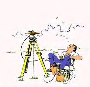
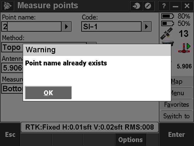
30 SV s 11,000 miles up Signals you can t see Go into a receiver that you can t see inside of Comes out of receiver and goes into a data collector using another wireless invisible method (Bluetooth) Spits out positions you are supposed to believe?

31
32 Faith? I *know* it is going to work Because the salesman told me it would..and I paid big $ s for it!
33 Hope? I would rather be lucky than good anyday How s that working for you?
34 Proof? Test against known values Redundancy
35 Accuracy and precision may be improved: If we follow directions If we stay within the operating limits of the equipment If we use the equipment properly If we use the right equipment for the job If we use care and preplanning If we build redundancies into the measurement If we can trust the people who are using the equipment! So nothing is new here! Hi-tech or not, we still need to use caution. 10/19/

36
37
38
39 1 - dual frequency GPS + GLONASS GNSS base receiver 1- dual frequency GPS + GLONASS GNSS high quality antenna 1- GNSS antenna cable 1- fixed height tripod, weights for the legs on long occupations 1- lead-acid battery with power lead to receiver. (Note: typical power input level on GNSS receivers is in the range of 10.5 volts 28 volts. Users frequently use a 12 volt lawn tractor battery)

40
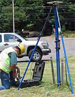
41

42
43 25 watt- 35 watt base radio (FCC) licensed (required with severe noncompliance penalties) 2-4 channels (10 or more recommended) Lead acid battery power cable, antenna mast, antenna tripod or mount for base tripod, data cable
44 Range is typically 5 km - 8 km (3 miles -5 miles) A full-size whip antenna option will enhance communications. Regardless of the type of external battery used, it should supply at least 12 volts and should be fully charged. An underpowered battery can severely limit communication range.

45 The base broadcast radio antenna should be raised to the maximum height possible. Studies have shown that an increase in antenna height from 5 to 20 will increase the broadcast range from 5 miles to 11 miles. The study shows a doubling in antenna height will increase the range by 40%. However, any height over 25 should use a low-loss cable.
46

47
48 1-dual frequency GPS + GLONASS GNSS integrated receiver/antenna, internal batteries 1- carbon fiber rover pole (two sections fixed height), circular level vial Or Adjustable rover pole The condition of the rover pole should be straight and not warped or bent in any manner.
49 1 rover pole bipod or tripod with quick release legs 1- data collector, internal battery and pole mount bracket 1- datalink between Receiver and Data Collector Cable Bluetooth wireless connection
50 Adjust the base and rover circular level vial before every campaign As a good practice or if the circular level vial is not adjusted, it is still possible to eliminate the possible plumbing error by taking two locations on a point with the rover pole rotated 180 between each location
51 A rover pole with an adjusted standard 40 minute vial located about midpoint of the length should introduce a maximum leveling error of no more than 2.5 mm (less than 0.01 feet). It should be noted that 10 minute vials are available.

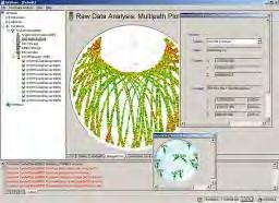
52 Even with RTK at the rover Especially for control points
53 The greatest contributor to error in GPS measurement is human error. Misreading antenna height measurements Transposing numbers entered electronically and/or on the GPS observation log Rushing observations Poor centering and leveling over points Observing the wrong survey point for example, observing a reference mark instead of the actual mark itself Incorrect equipment configuration settings
54 A measure of the geometry of the visible satellite constellation. Ideal orientation of four or more satellites Spaced equally around the receiver Including one above and one below Not physically possible due to us being on the earth s surface A low numeric Dilution of Precision value represents a good satellite configuration, whereas a higher value represents a poor satellite configuration.

55
56

57 Precision Dilution of Precision Most common Shows dilution in three dimensions Values A DOP value of less than 2 is considered excellent About as good as it gets, does not happen often, requires a clear view of sky to the horizon DOP values of 2 to 3 are considered very good DOP values of 4 to 5 are acceptable for most other than very precise work DOP values greater than 6 stop working.
58 It is helpful to partially mitigate the worst effects of atmospheric delay and refraction by setting an elevation mask (cut off angle) of to block the lower satellites signals which have the longest run through the atmosphere. A 10 mask is recommended.

59
60 Urban canyons Tall buildings block the sky Glass and metal covered reflect GNSS signals very well The receiver s multi-path rejection capability may actually be overloaded. Overhead power lines The higher the power, the worse for GNSS Look at easement width on power lines Electromagnetic radiation surrounding power lines Can interfere Hard or impossible to model this error
61 Forest canopy? Dense canopy cover can obscure the sky and interfere with the incoming satellite signal. The problem is even worse if the vegetation is wet since the liquid water itself can also interfere with the signal. User s experience using GNSS under canopy? Western Oklahoma version of clear sky

62
63 The control of a classical RT positioning survey is always in the hands of the rover. Need to have an awareness of all the important conditions and variables in order to get good RT results. In RT positioning, It Depends is the answer to most questions.
64 Proven control monumentation with a high degree of integrity Data precision is monitored as the work proceeds Points with known values are checked Before During After Redundant locations are taken on each important point.

65 THIS NOT THIS
66 It is possible to perform an accurate RT session from an autonomous-positioned base station point if the correct position can be introduced to the project in the data collector or in the office software later. In fact, it is much better to establish a new, completely open sky view site for the base than it is to try to occupy an existing reliable, well known monument with a somewhat obscured sky view.
67 Areas with probable multipath conditions should not be used for RT positioned control sites -especially not for a base station position
68 These sites include locations under or very near tree canopy structures within 30 m that are over the height of the antenna nearby vehicles and nearby metal objects abutting large water bodies nearby signs.
69 Set the base at a wide open site Set rover elevation mask between 10 & 15 The more satellites the better The lower the PDOP the better The more redundancy the better Beware multipath Beware long initialization times
70 Beware antenna height blunders Survey with fixed solutions only Always check known points before, during and after new location sessions Keep equipment adjusted for highest accuracy Communication should be continuous while locating a point Precision displayed in the data collector is usually at the 68 percent level (or 1σ), which is only about half the error spread to get 95 percent confidence Have back up batteries & cables RT does not like tree canopy or tall buildings
71 RTK give coordinates on positions Other information is needed for records datum/adjustment/epoch of the base station Field conditions Temperature, wind, precipitation, storms Equipment used, especially the antennas Firmware in Receivers and Collectors Redundancy used Calibration or localization information Date, time and field technicians names
72 RT positioning of important data points can not be done reliably without some form of redundancy Redundancy is critical for important point positions using RT The external battery should supply at least 12 volts and should be fully charged. An underpowered battery can severely limit communication range
73 The base broadcast radio antenna should be raised to the maximum height possible. Make sure that the base and rover circular level vials are in adjustment. Set the base in as open a position as possible Data link should be continuous during measurements

74

75 Limited range from single reference station Potential gross error in establishing reference station No integrity monitoring Dependency on single reference station Productivity loss Security Communications Power supply
76 Error (m) % 67% 95% 95% Distance (km)

77 Continuously Operating Reference Station


78 Located at a precisely known position Records GPS data for later use Post Processing Generates GPS corrections for immediate use Real - time, broadcast or dial - in Results degrade with distance from Reference Station Useable range can be from 10 km to 500 km (RTK vs DGPS)


79 Components of a CORS site Monumentation Hardware Software Communications
80 Network of Single RTK Stations Accuracy, Reliability, Availability Good Bad
81 RTK Reference Stations Network Accuracy, Reliability, Availability Good Bad

82 Reference Station data streams back to server through LAN or Internet

83 Roving receiver sends an NMEA string back to server using cellular modem - VRS position is established VRS NMEA - GGA
84 Server uses VRS position to create corrected observables and broadcasts to rover VRS
85 Eliminate the need for local base stations Only GPS rover receivers are needed Less initial GPS expense because it doubles the number of GPS systems you have now No surveyor required to watch the base station Consistent known datum and coordinate system
86 Cell phone. Bluetooth or old school cable Internal modem in receiver Internal modem in data collector Other modem like Airlink Ravens Intiucom RTK Bridge WiFi Hotspots MiFI devices Phones Other WiFi s Without the communication link VRS is not possible
87 Pick whoever has the best coverage in your area Data coverage not just voice In newer systems, such as 3G and EDGE, voice no longer takes precedence over data Only way to really know which carrier has best coverage is to test it yourself Maps are VERY generalized
 = 18.6KB 1 hour: (18.6KB x 60) = 1.11MB 8 hrs: (1.11MB x 8) = 8.")
88 Here is approximately would you could expect using CMR+ with 14 SVs for 8hrs straight: 1 sec: 310bytes 1 min: (310bytes x 60) = 18.6KB 1 hour: (18.6KB x 60) = 1.11MB 8 hrs: (1.11MB x 8) = 8.93MB 5GB (typical plan amount): 24/7 for 30 days

89


90

91
92
93 Total number: 424 (these are August 2011 counts) Agriculture: 64 Surveyor: 306 Construction: 27 Other (GIS) : 26 (which includes: city & county organizations; public water, universities, etc.) Of that Total Number above: around 120 are Out of State signups around 70 are MoDOT employees
94 Check Equipment, Data Collector Parameters & Site information Measure the actual height of the antenna reference point (ARP) on the rover pole Ensure that all necessary and correct projection parameters are in the data collector Ensure that all project data are in the data collector Adjust the rover pole bubble before every campaign
95 Check Equipment continued Test wireless data communications (cell/cdma/sim card/etc.) for Internet connectivity at the project site. Make sure the GNSS unit and the communication device batteries are fully charged and that there are backups. For orthometric heights, be sure to preload the current geoid model supplied by the NGS
96 Conditions Use mission planning Check Space Weather Always be aware of multipath conditions. Be aware of possible electrical interference from sources such as high tension transmission lines or broadcast antennas
97 Coordinates Know what datum, adjustment and epoch is needed for the coordinate data produced Know what datum, adjustment and epoch coordinates are supplied by the RTN Grid or Ground?
98 Communication Robust communication is the key to an effective RTN Wireless internet from a variety of sources lets you roam anywhere within an RTN Many options The GNSS solution at a point of interest should become fixed in a normal amount of time and should remain fixed for the duration of the actual data collection
99 Communication Save all communication configuration information for hardware, firmware, user names, passwords, serial numbers, and Bluetooth connections When no cellular coverage Break out your base and radio Use OPUS or OPUS RS Benefit of having your RTN tied to NSRS
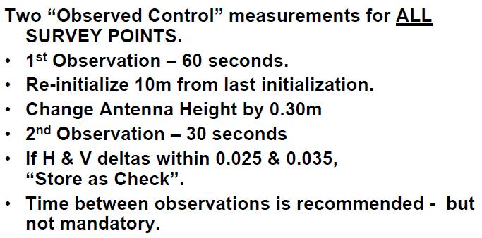
100 Constraining to passive monuments (a.k.a. Calibrations or Localizations) Orthometric Elevations Use four Benchmarks surrounding site PLUS the geoid model Use one Benchmark, use geoid model, check to another Benchmark Just use what comes out of the RTN Probably should check at least one Benchmark if possible Why are my elevations off by 100 feet?
101 Constraining to passive monuments (a.k.a. Calibrations or Localizations) Horizontal accuracy of RTN is essentially the same as survey grade RTK Calibrate for Checking coordinate consistancy Tying to project coordinates Sanity check when you are given coordinates and no metadata For best vertical results, calibrate to local, known, trusted, high quality Benchmarks
102 Collection Check a known coordinate point before, during and at the end of data collection Provides check on Antenna height blunders Incorrect projection parameters Faulty calibrations Initialization Set an elevation cut-off or mask of between 10 and 15.
103 Confidence Redundancy is the king of RT GNSS positioning Redundancy gives confidence and refines the precision of the data Robust wireless Internet connectivity Coordinate accuracy will suffer if Latencies rise above 2 seconds Communication is intermittent during data capture Checks on known points Before, During, After Obvious Multipath avoid it
104 Summary Four basic elements to achieve reliability Communication, Checks, Redundancy, Multipath Good GNSS gear, good field conditions and good field procedures will yield good Real Time positions
105 What is an RTK shot? How can you add redundancy to your work?
106 Need to measure it more than once to know for sure that it is right How do we achieve redundancy using RTK? Measure it more than once Measurements separated by time Change in the satellite constellation
107 Classical RTK Move the base, observe points again Store data at each base location Submit to OPUS If setting two points for control Measuring between them with a total station is an excellent check You can store more than one observation, and post process and adjust in office software.
108 Classically.four hours How big is your budget on the job? Studies in Great Britain have shown For precise work where the height component is important, observe for three minutes and then another three minutes. A separation of 20 minutes gives a 10-20% improvement in coordinate accuracy 45 minute separation gives a 15-30% improvement over a single epoch solution.
109 Measure your point Dump the antenna Let it reintialize Measure again Store as same number and look at differences Store as a different number and inverse More of a warm and fuzzy check than anything But better than nothing
110 For practical reasons, most users cannot wait four hours between RTK observations due to cost and logistics. A better alternative for a check shot than moving the base Record your first point measurement Force receiver to lose initialization Raise elevation mask to 90 degrees Change antenna height by 0.3 meters (0.98 feet) Longer than one wavelength of the GPS signal
111 Change antenna mask back to 10 degrees Do a Known Point initialization on the point you stored If it succeeds, might put more faith in that than moving the base If it does not succeed, the first shot probably wasn t any good.
112
113


114 MEASURED THE 2 ND TIME Selected Average Computed average shown
115 YOU CAN AVERAGE AS MANY TIMES AS YOU WANT

116 REVIEWING DETAILS ALL THE SHOTS


117 FINAL AVERAGE FINAL AVERAGE


118
119


120

121
122 Takes longer to get to most points than it does to shoot them Longer observation is better Redundancy is better than longer observation I would rather see two 60 second shots than one 180 second shot NO single shots on important points Just too many variables
123
9/26/2016. Accuracy with GNSS What are you getting? Presented By Tom Bryant PLS Kelly Harris PLS Seiler Instrument
 Accuracy with GNSS What are you getting? Presented By Tom Bryant PLS Kelly Harris PLS Seiler Instrument 1 What We Will Talk About Today What coordinate system should I use in my data collector Site Calibrations-what
Utilizing A GNSS Network Solution for Utility Applications
 Utilizing A GNSS Network Solution for Utility Applications David Newcomer, PE, PLS GPServ, Inc. newcomer@ (407) 601-5816 AGENDA Types and accuracies of data collection o Autonomous o Meter + o Sub-meter
DYNAMIC RT TECHNOLOGY
 DYNAMIC RT TECHNOLOGY GLOBAL NAVIGATION SATELLITE SYSTEMS (GNSS) POTENTIAL FUTURE DEVELOPMENTS(2005 2017?) GPS MODERNIZATION BLOCK IIF & III GLONASS ENHANCEMENTS (K & M) EUROPEAN UNION - GALILEO CHINA
Chapter 6 GPS Relative Positioning Determination Concepts
 Chapter 6 GPS Relative Positioning Determination Concepts 6-1. General Absolute positioning, as discussed earlier, will not provide the accuracies needed for most USACE control projects due to existing
GNSS 101 Bringing It Down To Earth
 GNSS 101 Bringing It Down To Earth Steve Richter Frontier Precision, Inc. UTM County Coordinates NGVD 29 State Plane Datums Scale Factors Projections Session Agenda GNSS History & Basic Theory Coordinate
Guidelines for RTK/RTN GNSS Surveying in Canada
 Guidelines for RTK/RTN GNSS Surveying in Canada July 2015 Version 1.2 Ministry of Transportation Ministère des Transports EARTH SCIENCES SECTOR GENERAL INFORMATION PRODUCT 100-E Main Authors: Brian Donahue,
Appendix D Brief GPS Overview
 Appendix D Brief GPS Overview Global Positioning System (GPS) Theory What is GPS? The Global Positioning System (GPS) is a satellite-based navigation system, providing position information, accurate to
The Role of F.I.G. in Leading the Development of International Real-Time Positioning Guidelines
 The Role of F.I.G. in Leading the Development of International Real-Time Positioning Guidelines, USA Key Words: RTN, real-time, GNSS, Guidelines SUMMARY The rapid growth of real-time reference station
The Reasons to Succeed or to Fail a GNSS Network RTK Project
 The Reasons to Succeed or to Fail a GNSS Network RTK Project Joël van Cranenbroeck, Managing Director CGEOS Creative Geosensing sprl-s, Belgium Andy Yin, International Sales Director ComNav Technology
GNSS & Coordinate Systems
 GNSS & Coordinate Systems Matthew McAdam, Marcelo Santos University of New Brunswick, Department of Geodesy and Geomatics Engineering, Fredericton, NB May 29, 2012 Santos, 2004 msantos@unb.ca 1 GNSS GNSS
FieldGenius Technical Notes GPS Differential Corrections
 FieldGenius Technical tes GPS Differential Corrections Introduction The accuracy requirement of survey grade or mapping grade GPS applications for real time positioning requires the use of differential
High Precision GNSS for Mapping & GIS Professionals
 High Precision GNSS for Mapping & GIS Professionals Agenda Address your needs for GNSS knowledge. GNSS Basics Satellite Ranging Fundamentals (Code $ Carrier) Differential Corrections (Post Processed $
FieldGenius Technical Notes GPS Terminology
 FieldGenius Technical Notes GPS Terminology Almanac A set of Keplerian orbital parameters which allow the satellite positions to be predicted into the future. Ambiguity An integer value of the number of
Real Time Kinematic VALUE GUIDE (US, Canada, Australia & New Zealand) CLICK THE ARROW TO GET STARTED
 CLICK THE ARROW TO GET STARTED") Real Time Kinematic VALUE GUIDE (US, Canada, Australia & New Zealand) Copyright 2014 Deere & Company This material is the property of Deere & Company. All use, disclosure, and/or reproduction not specifically
Real Time Kinematic VALUE GUIDE (US, Canada, Australia & New Zealand) Copyright 2014 Deere & Company This material is the property of Deere & Company. All use, disclosure, and/or reproduction not specifically
Guidelines for RTK/RTN GNSS Surveying in Canada
 Guidelines for RTK/RTN GNSS Surveying in Canada Brian Donahue GSD/NRCan Jan Wentzel SGB/NRCan Ron Berg MTO December 2012 Version 1.0.7 Ministry of Transportation Table of Contents Table of Acronyms...
ENGI 3703 Surveying and Geomatics
 Satellite Geometry: Satellites well spread out in the sky have a much stronger solution to the resection type problem (aka trilateration) then satellite that are grouped together. Since the position of
Errors in GPS. Errors in GPS. Geodetic Co-ordinate system. R. Khosla Fall Semester
 Errors in GPS Errors in GPS GPS is currently the most accurate positioning system available globally. Although we are talking about extreme precision and measuring distances by speed of light, yet there
PRINCIPLES AND FUNCTIONING OF GPS/ DGPS /ETS ER A. K. ATABUDHI, ORSAC
 PRINCIPLES AND FUNCTIONING OF GPS/ DGPS /ETS ER A. K. ATABUDHI, ORSAC GPS GPS, which stands for Global Positioning System, is the only system today able to show you your exact position on the Earth anytime,
Using RTK GNSS Wisely
 Using RTK GNSS Wisely February 017 Autonomous Positioning Differential Positioning Concept: Detect and cancel identical errors with simultaneous observation. F + E = G + E 1 Static & RTK Computations Static
GPS Errors. Figure 1. Four satellites are required to determine a GPS position.
 Expl ai ni nggps:thegl obalposi t i oni ngsyst em since a minimum of four satellites is required to calculate a position (Fig 1). However, many newer GPS receivers are equipped to receive up to 12 satellite
Trimble GNSS Infrastructure
 Trimble GNSS Infrastructure A History of Innovation Trimble, the first company to offer commercial GPS products company to integrate GPS with communications technology RTK system in the market in 1994
Using Dual Frequency GPS Under Tree Canopy
 Using Dual Frequency GPS Under Tree Canopy Presented by: Jon Aschenbach Resource Supply, LLC PO Box 663 West Linn, OR 97068 503-521-0888 Field Technology Conference 11-2015 Four Scenarios Will Be Reviewed
GLOBAL POSITIONING SYSTEMS. Knowing where and when
 GLOBAL POSITIONING SYSTEMS Knowing where and when Overview Continuous position fixes Worldwide coverage Latitude/Longitude/Height Centimeter accuracy Accurate time Feasibility studies begun in 1960 s.
USER MANUAL FIELDBEE AND RTK BEE STATION FULL VERSION. WE PROVIDE ONLINE SUPPORT: VERSION 1.0.
 USER MANUAL FULL VERSION VERSION 1.0. FIELDBEE AND RTK BEE STATION WE PROVIDE ONLINE SUPPORT: support@efarmer.mobi info@efarmer.mobi CONTENTS TABLE OF CONTENTS INTRODUCTION... 3 3 WAYS OF USING FIELDBEE...
What is a GPS How does GPS work? GPS Segments GPS P osition Position Position Accuracy Accuracy Accuracy GPS A pplications Applications Applications
 What is GPS? What is a GPS How does GPS work? GPS Segments GPS Position Accuracy GPS Applications What is GPS? The Global Positioning System (GPS) is a precise worldwide radio-navigation system, and consists
Problem Areas of DGPS
 DYNAMIC POSITIONING CONFERENCE October 13 14, 1998 SENSORS Problem Areas of DGPS R. H. Prothero & G. McKenzie Racal NCS Inc. (Houston) Table of Contents 1.0 ABSTRACT... 2 2.0 A TYPICAL DGPS CONFIGURATION...
Connecting a Cadastral Survey to PNG94 using GNSS
 43rd Association of Surveyors PNG Congress, Lae, 12th-15th August 2009 Connecting a Cadastral Survey to PNG94 using GNSS Richard Stanaway QUICKCLOSE Workshop overview Legal requirements to connect surveys
NJDEP GPS Data Collection Standards for GIS Data Development
 NJDEP GPS Data Collection Standards for GIS Data Development Bureau of Geographic Information Systems Office of Information Resource Management April 24 th, 2017 Table of Contents 1.0 Introduction... 3
SPAN Technology System Characteristics and Performance
 SPAN Technology System Characteristics and Performance NovAtel Inc. ABSTRACT The addition of inertial technology to a GPS system provides multiple benefits, including the availability of attitude output
Precise Surveying with L1 RTK
 International Global Navigation Satellite Systems Society IGNSS Symposium 2007 The University of New South Wales, Sydney, Australia 4 6 December, 2007 Precise Surveying with L1 RTK Ian Iredale Mapsoft
GUIDANCE NOTES FOR GNSS NETWORK RTK SURVEYING IN GREAT BRITAIN
 GUIDANCE NOTES FOR GNSS NETWORK RTK SURVEYING IN GREAT BRITAIN ISSUE 4 MAY 2015 TSA Collaboration between: This leaflet has been produced to provide surveyors, engineers and their clients with guidelines
What is it? History. Other systems. How does it work? Trilateration GEOG 201 4/28/2010. Instructor: Pesses 1. {06} The Global Positioning System
 What is it? {06} The Global Positioning System G.P.S. = Global Positioning System Different from G.I.S. (Geographic Information Systems) Map Interpretation & GPS Spring 2010 M. Pesses History Conceived
GNSS CONSTRUCTION INSPECTION EQUIPMENT
 Project: Jamaica-Winhall STP 2904(1) Advertised Date: 5/30/2018 GNSS CONSTRUCTION INSPECTION EQUIPMENT DESCRIPTION. This work shall consist of furnishing, configuring, installing, maintaining, and removing
GPS: The Basics. Darrell R. Dean, Jr. Civil and Environmental Engineering West Virginia University. Expected Learning Outcomes for GPS
 GPS: The Basics Darrell R. Dean, Jr. Civil and Environmental Engineering West Virginia University Expected Learning Outcomes for GPS Explain the acronym GPS Name 3 important tdt dates in history of GPS
The Global Positioning System II Field Experiments
 The Global Positioning System II Field Experiments 5-1 Mexico DGPS Field Campaign Cenotes in Tamaulipas, MX, near Aldama 5-2 Are Cenote Water Levels Related? 5-3 DGPS Static Survey of Cenote Water Levels
Indian Institute of Technology Kanpur Department of Civil Engineering
 Indian Institute of Technology Kanpur Department of Civil Engineering Inquiry No- CE/JNM/2013-14/R-10 30 December, 2013 Subject: Quotation for supply of Integrated System/Smart System Reflectorless Robotic
Bulletin. Loss Control. Land Surveyors. Towards Achieving Measurement Redundancy* Professional Liability Insurance. Background
 Bulletin No. 13 February 2008 Revised November 2014 ENCON Group Inc. Telephone 613-786-2000 Facsimile 613-786-2001 Toll Free 800-267-6684 www.encon.ca Loss Control Bulletin Land Surveyors Professional
Mark s MobileMapper 120, ProMark 120, ProMark 220 Notes
 1 Mark s MobileMapper 120, ProMark 120, ProMark 220 Notes By: Mark Silver, ms@igage.com, +1 801-412-0011 Updated: 19 November 2012 All of the MobileMapper and ProMark products, software and accessories
Asian Journal of Science and Technology Vol. 08, Issue, 11, pp , November, 2017 RESEARCH ARTICLE
 Available Online at http://www.journalajst.com ASIAN JOURNAL OF SCIENCE AND TECHNOLOGY ISSN: 0976-3376 Asian Journal of Science and Technology Vol. 08, Issue, 11, pp.6697-6703, November, 2017 ARTICLE INFO
670 10/26/17 SSD: 07/14/16, 09/16/17 Page 1 of 6
 SSD: 07/14/16, 09/16/17 Page 1 of 6 S P E C I A L P R O V I S I O N Section MISCELLANEOUS INCIDENTALS Item.822 - GNSS Construction Inspection Equipment Description SAMPLE PROJECT 12345 10/30/17 1.1 Work
Connecting a Survey to PNG94 and MSL using GNSS
 45th Association of Surveyors PNG Congress, Madang, 19-22 July 2011 Connecting a Survey to PNG94 and MSL using GNSS Richard Stanaway QUICKCLOSE Workshop overview Legal requirements to connect surveys to
The Global Positioning Sytem II 10/19/2017
 The Global Positioning System II Field Experiments 10/19/2017 5-1 Mexico DGPS Field Campaign Cenotes in Tamaulipas, MX, near Aldama 10/19/2017 5-2 Are Cenote Water Levels Related? 10/19/2017 5-3 M. Helper,
GPS for. Land Surveyors. Jan Van Sickle. Fourth Edition. CRC Press. Taylor & Francis Group. Taylor & Francis Croup, an Informa business
 GPS for Land Surveyors Fourth Edition Jan Van Sickle CRC Press Taylor & Francis Group Boca Raton London New York CRC Press is an imprint of the Taylor & Francis Croup, an Informa business Contents Preface
Hitchhiker s s Guide Global Position System. Global Position System
 Hitchhiker s s Guide Global Position System Myles Sutherland Craig Greenwald Mike Shaw John Rogers Hitchhiker s s Guide Global Position System (GPS) Myles Sutherland - ESRI Craig Greenwald ESRI John Rogers
TDS Ranger Survey Pro CE Version RTK Base on known Control Point. RTK Rover - Localization with Control Points.
 TDS Ranger Survey Pro CE Version 2.1.8 RTK Base on known Control Point. RTK Rover - Localization with Control Points. Pre-load control Coordinates and appropriate NGS Geoid 99/96 data files into the Ranger
TSC1 - Asset Surveyor Operation
 TSC1 - Asset Surveyor Operation Menu Icons (current choice is highlighted) Data collection File manager Main menu Navigation GPS Position Battery Status PC Card (if used) Real-Time Status Number of Satellites
GPS Accuracy Comparison. Tom Biernacki Florida Department of Environmental Protection
 GPS Accuracy Comparison Tom Biernacki Florida Department of Environmental Protection What Effects the accuracy of GPS? Atmospheric delay Multipath bounce Weak receiver algorithms Atmospheric Delay Signal
LAB 1 METHODS FOR LOCATING YOUR FIELD DATA IN GEOGRAPHIC SPACE. Geog 315 / ENSP 428
 LAB 1 METHODS FOR LOCATING YOUR FIELD DATA IN GEOGRAPHIC SPACE Geog 315 / ENSP 428 Lab 1 Schedule Introduction to bio-physical field data collection (8:00-8:20am) Locating your data on the earth: NAVSTAR
Introduction to Geographic Information Science. Last Lecture. Today s Outline. Geography 4103 / GNSS/GPS Technology
 Geography 4103 / 5103 Introduction to Geographic Information Science GNSS/GPS Technology Last Lecture Geoids Ellipsoid Datum Projection Basics Today s Outline GNSS technology How satellite based navigation
Specifications. Trimble BX982 Modular GNSS Heading Receiver
 Name Configuration Option Base and Rover interchangeability Rover position update rate Rover maximum range from base radio Rover operation within a VRS network Heading and Moving Base operation Factory
Global Positioning Systems - GPS
 Global Positioning Systems - GPS GPS Why? What is it? How does it work? Differential GPS How can it help me? GPS Why?? Where am I? How do I get there? Where are you, and how do I get to You? WHO CARES???
Resection. We can measure direction in the real world! Lecture 10: Position Determination. Resection Example: Isola, Slovenia. Professor Keith Clarke
 Geography 12: Maps and Spatial Reasoning Lecture 10: Position Determination We can measure direction in the real world! Professor Keith Clarke Resection Resection Example: Isola, Slovenia Back azimuth
GNSS Receivers, Sensors, Desktop Solutions
 GNSS Receivers, Sensors, Desktop Solutions keep it simple high performance: the best GNSS tracking in field ready, reliable packages coupled with the best field and desktop software tools support and service
Global Positioning Systems -GPS
 Global Positioning Systems -GPS GPS Why? What is it? How does it work? Differential GPS How can it help me? GPS Why?? Where am I? How do I get there? Where are you, and how do I get to You? WHO CARES???
Sources of Geographic Information
 Sources of Geographic Information Data properties: Spatial data, i.e. data that are associated with geographic locations Data format: digital (analog data for traditional paper maps) Data Inputs: sampled
GE 113 REMOTE SENSING
 GE 113 REMOTE SENSING Topic 9. Introduction to Global Positioning Systems (GPS) and Other GNSS Technologies Lecturer: Engr. Jojene R. Santillan jrsantillan@carsu.edu.ph Division of Geodetic Engineering
SURVEYORS BOARD OF QUEENSLAND. RTK GNSS for Cadastral Surveys. Guideline
 SURVEYORS BOARD OF QUEENSLAND RTK GNSS for Cadastral Surveys Guideline 30 November 2012 RTK GNSS for Cadastral Surveys General The Surveyors Board of Queensland has recently become aware of some issues
Lecture 04. Elements of Global Positioning Systems
 Lecture 04 Elements of Global Positioning Systems Elements of GPS: During the last lecture class we talked about Global Positioning Systems and its applications. With so many innumerable applications of
S320 and SurvCE RTK Base Unknown Location
 S320 and SurvCE RTK Base Unknown Location Part Number 874-0303-000 Released April 17, 2012 Overview This document describes how to configure the S320 RTK base using SurvCE at an unknown location, perform
GPS Accuracies in the Field
 GPS Accuracies in the Field A short and informative talk by A. Richard Vannozzi, PLS Assistant Professor of Civil Technology/Surveying and Mapping Thompson School of Applied Science University of New Hampshire
Surveying in the Year 2020
 Surveying in the Year 2020 Johannes Schwarz Leica Geosystems My first toys 2 1 3 Questions Why is a company like Leica Geosystems constantly developing new surveying products and instruments? What surveying
COMPARISON OF RELATIVE AND ABSOLUTE PRECISION OF OHIO S WIDE AREA GPS NETWORK INCLUDING THE COMPARISON WITH ALTERNATIVE METHODS.
 COMPARISON OF RELATIVE AND ABSOLUTE PRECISION OF OHIO S WIDE AREA GPS NETWORK INCLUDING THE COMPARISON WITH ALTERNATIVE METHODS A Thesis Presented in Partial Fulfillment of the Requirements for the Degree
Technology Talk Bulletin
 Technology Talk Bulletin This Technology Talk Bulletin compares John Deere dealer s current Real Time Kinematic (RTK) base station approach to the different RTK technologies available. What is RTK? RTK
Procedures for Quality Control of GNSS Surveying Results Based on Network RTK Corrections.
 Procedures for Quality Control of GNSS Surveying Results Based on Network RTK Corrections. Limin WU, China Feng xia LI, China Joël VAN CRANENBROECK, Switzerland Key words : GNSS Rover RTK operations, GNSS
Datums and Tools to Connect Geospatial Data Accurately
 Datums and Tools to Connect Geospatial Data Accurately Pamela Fromhertz Colorado State Geodetic Advisor National Geodetic Survey National Oceanic and Atmospheric Administration GIS-T April 18, 2012 Loveland,
Beginners Guide to GPS Elevation Plus an Update on GPS Technology
 Beginners Guide to GPS Elevation Plus an Update on GPS Technology A TMS Presentation By: Jon Aschenbach Summerlake Enterprises 919 36 th Place Forest Grove, OR 97116 503-707-6236 Coeur d Alene, ID April,
GPS Pathfinder ProXH and ProXT Customer FAQs
 7 December 2009 GPS Pathfinder ProXH and ProXT Customer FAQs What is the GPS Pathfinder ProXH receiver? The GPS Pathfinder ProXH receiver is a fully integrated receiver, antenna and battery unit with Trimble
TDS Survey Pro CE Version Setup RTK Base on known NAD83/WGS84 Point: Mapping Plane Geoid99 Modeling.
 TDS Survey Pro CE Version 2.1.8 Setup RTK Base on known NAD83/WGS84 Point: Mapping Plane Geoid99 Modeling. Pre-load known NAD83 State Plane Coordinates and appropriate NGS Geoid 99/96 data files into the
The Global Positioning System
 The Global Positioning System 5-1 US GPS Facts of Note DoD navigation system First launch on 22 Feb 1978, fully operational in 1994 ~$15 billion (?) invested to date 24 (+/-) Earth-orbiting satellites
All you wanted to know about High Accuracy Data Collection Eric Muncy Precision Products Mapping-GIS Division
 All you wanted to know about High Accuracy Data Collection Eric Muncy Precision Products Mapping-GIS Division Tell me your name What School / Organization Any experience with GPS equipment What would you
GeoExplorer 6000 series: Customer FAQs
 16 July 2012 GeoExplorer 6000 series: Customer FAQs This document includes information about the Trimble GeoExplorer 6000 series GeoXH and GeoXT handhelds. For information about the Trimble GeoXR Network
SERVIR: The Portuguese Army CORS Network for RTK
 SERVIR: The Portuguese Army CORS Network for RTK António Jaime Gago AFONSO, Rui Francisco da Silva TEODORO and Virgílio Brito MENDES, Portugal Key words: GNSS, RTK, VRS, Network ABSTRACT Traditionally
ELEMENTS OF THE NATIONAL SPATIAL REFERENCE SYSTEM
 Dave Doyle NGS Chief Geodetic Surveyor dave.doyle@noaa.gov 301-713-3178 ELEMENTS OF THE NATIONAL SPATIAL REFERENCE SYSTEM ESRI SURVEY SUMMIT San Diego, CA June 17, 2007 ftp://ftp.ngs.noaa.gov/dist/daved/esri
NR402 GIS Applications in Natural Resources
 NR402 GIS Applications in Natural Resources Lesson 5 GPS/GIS integration Global Positioning System (GPS)..a global navigation system that everyone can use What is GPS? How does it work? How accurate is
GPS Milestones, cont. GPS Milestones. The Global Positioning Sytem, Part 1 10/10/2017. M. Helper, GEO 327G/386G, UT Austin 1. US GPS Facts of Note
 The Global Positioning System US GPS Facts of Note DoD navigation system First launch on 22 Feb 1978, fully operational in 1994 ~$15 billion (?) invested to date 24 (+/-) Earth-orbiting satellites (SVs)
One Source for Positioning Success
 novatel.com One Source for Positioning Success RTK, PPP, SBAS OR DGNSS. NOVATEL CORRECT OPTIMIZES ALL CORRECTION SOURCES, PUTTING MORE POWER, FLEXIBILITY AND CONTROL IN YOUR HANDS. NovAtel CORRECT is the
ACCURACIES OF VARIOUS GPS ANTENNAS UNDER FORESTED CONDITIONS
 ACCURACIES OF VARIOUS GPS ANTENNAS UNDER FORESTED CONDITIONS Brian H. Holley and Michael D. Yawn LandMark Systems, 122 Byrd Way Warner Robins, GA 31088 ABSTRACT GPS accuracy is much more variable in forested
Leica Spider Infrastructure HW Solutions Introducing: Leica GR30 & GR50
 Leica Spider Infrastructure HW Solutions Introducing: Leica GR30 & GR50 Reliable solutions for today and tomorrow Leica Spider Integrated Solutions Introducing: Leica GR30 & GR50 Outline Introducing Leica
36. Global Positioning System
 36. Introduction to the Global Positioning System (GPS) Why do we need GPS? Position: a basic need safe sea travel, crowed skies, resource management, legal questions Positioning: a challenging job local
Best field practices for GIS Data collection: Presented by, Jacob Wittenberg Frontier Precision, Inc.
 Best field practices for GIS Data collection: Presented by, Jacob Wittenberg Frontier Precision, Inc. Agenda What is GNSS Code and Carrier Data H-Star Processing Best Practices Code and Carrier Solutions
The Global Positioning System II Field Experiments. 10/10/2013 GEO327G/386G, UT Austin 5-1
 The Global Positioning System II Field Experiments 10/10/2013 GEO327G/386G, UT Austin 5-1 Mexico DGPS Field Campaign Cenotes in Tamaulipas, MX, near Aldama 10/10/2013 GEO327G/386G, UT Austin 5-2 Are Cenote
National Report of Greece to EUREF 2009
 National Report of Greece to EUREF 2009 M. Gianniou KTIMATOLOGIO S.A. (Hellenic Cadastre) 1 Introduction In 2007, KTIMATOLOGIO S.A (Hellenic Cadastre) established HEPOS, the HEllenic POsitioning System,
CARRIER PHASE VS. CODE PHASE
 DIFFERENTIAL CORRECTION Code phase processing- GPS measurements based on the pseudo random code (C/A or P) as opposed to the carrier of that code. (1-5 meter accuracy) Carrier phase processing- GPS measurements
ArcGIS Apps and GPS GNSS Connections. By: Colin Lawrence and Kiersten Hudson
 ArcGIS Apps and GPS GNSS Connections By: Colin Lawrence and Kiersten Hudson Agenda ArcGIS Apps and high accuracy data The importance of high accuracy data Making connections to external receivers Bringing
GPS for GIS Data Collection - 101
 GPS for GIS Data Collection - 101 Speaker: Eric Gakstatter, Editor of GPS World s Survey Scene Newsletter & Geospatial Solutions Guest Commentator: Craig Greenwald, Technical Director, GeoMobile Innovations,
MGA Webinar Series : 1 Very Cheap RTK Receivers: Changing the Landscape of Positioning Services
 MGA Webinar Series : 1 Very Cheap RTK Receivers: Changing the Landscape of Positioning Services Dinesh Manandhar Center for Spatial Information Science The University of Tokyo Contact Information: dinesh@iis.u-tokyo.ac.jp
al T TD ) ime D Faamily Products The RTD Family of products offers a full suite of highprecision GPS sensor positioning and navigation solutions for:
 ime D Faamily Products The RTD Family of products offers a full suite of highprecision GPS sensor positioning and navigation solutions for:") Reeal ynnamics al T amics (R TD ) ime D RTD) Time Dy Faamily mily ooff P roducts Products The RTD Family of products offers a full suite of highprecision GPS sensor positioning and navigation solutions
Reeal ynnamics al T amics (R TD ) ime D RTD) Time Dy Faamily mily ooff P roducts Products The RTD Family of products offers a full suite of highprecision GPS sensor positioning and navigation solutions
KRONOS C3 Receiver User Guide
 KRONOS C3 Receiver User Guide Copyright Copyright 2015-2016 HORIZON Survey Instruments Services Pte Ltd. All rights reserved. The KRONOS are trademark of Survey Instruments Services Pte Ltd. All other
Raveon M7 GX Frequently Asked Questions
 Technical Brief AN134Rev A3 Raveon M7 GX Frequently Asked Questions By John Sonnenberg Raveon Technologies Corp How far will a 5-watt UHF radio communicate? An excellent question, but very difficult to
Experiences with Fugro's Real Time GPS/GLONASS Orbit/Clock Decimeter Level Precise Positioning System
 Return to Session Directory DYNAMIC POSITIONING CONFERENCE October 13-14, 2009 Sensors Experiences with Fugro's Real Time GPS/GLONASS Orbit/Clock Decimeter Level Precise Positioning System Ole Ørpen and
EXPERIMENTAL RESULTS OF LEX CORRECTIONS USING FARMING MACHINE
 Sixth Meeting of the International Committee on Global Navigation Satellite Systems (ICG) EXPERIMENTAL RESULTS OF LEX CORRECTIONS USING FARMING MACHINE Masayuki Kanzaki Hitachi Zosen Corporation Prof.
Global Positioning Systems (GPS) Trails: the achilles heel of mapping from the air / satellites
 Trails: the achilles heel of mapping from the air / satellites") Global Positioning Systems (GPS) Trails: the achilles heel of mapping from the air / satellites Google maps updated regularly by local users using GPS Also: http://openstreetmaps.org GPS applications
Global Positioning Systems (GPS) Trails: the achilles heel of mapping from the air / satellites Google maps updated regularly by local users using GPS Also: http://openstreetmaps.org GPS applications
S a t e l l i t e T i m e a n d L o c a t i o n. N o v e m b e r John Fischer VP Advanced R&D
 STL - S a t e l l i t e T i m e a n d L o c a t i o n N o v e m b e r 2 0 1 7 John Fischer VP Advanced R&D jfischer@orolia.com 11/28/201 1 7 WHY AUGMENT GNSS? Recent UK Study Economic Input to UK of a
Precise Positioning with NovAtel CORRECT Including Performance Analysis
 Precise Positioning with NovAtel CORRECT Including Performance Analysis NovAtel White Paper April 2015 Overview This article provides an overview of the challenges and techniques of precise GNSS positioning.
Trimble NetR9 Reference Receiver Series: Frequently Asked Questions
 July 2010 Trimble NetR9 Reference Receiver Series: Frequently Asked Questions What is the Trimble NetR9 GNSS reference receiver? The Trimble NetR9 GNSS (Global Navigation Satellite System) reference receiver
Principal Investigator Co-Principal Investigator Co-Principal Investigator Prof. Talat Ahmad Vice-Chancellor Jamia Millia Islamia Delhi
 Subject Paper No and Title Module No and Title Module Tag Geology Remote Sensing and GIS Concepts of Global Navigation Satellite RS & GIS XXXIII Principal Investigator Co-Principal Investigator Co-Principal
Computer Aided Earthmoving System
 Computer Aided Earthmoving System CAES for Landfills Landfill Compactors Track-Type Tractors Wheel Tractor Scrapers Motor Graders System Components Communications Radio GPS Antenna GPS Receiver In-Cab
Engr 1202 ECE. Clean Room Project
 Engr 1202 ECE Clean Room Project Dilbert the engineer gets special recognition September 2005 2014 Version does not even have my name! AC vs. DC Circuits DC and AC devices in everyday life DC Devices
Next Generation Positioning Infrastructure
 Next Generation Positioning Infrastructure The GNSS Network in the 21 st Century Joel VAN CRANENBROECK & Partners Beyond East & West GeoSensing Community 1 INFRASTRUCTURE "The installations that form the
METIS Second Master Training & Seminar. Augmentation Systems Available in Egypt
 METIS Second Master Training & Seminar Augmentation Systems Available in Egypt By Eng. Ramadan Salem M. Sc. Surveying and Geodesy Email: ramadan_salem@link.net Page 1 Augmentation Systems Available in