European Space Agency (ESA) Landsat MSS/TM/ETM+/OLI Archive: 42 years of our history
|
|
|
- Kristin Copeland
- 5 years ago
- Views:
Transcription
1 This image cannot currently be displayed. European Space Agency (ESA) Landsat MSS/TM/ETM+/OLI Archive: 42 years of our history Landsat MSS Dataset Improvements and Multi Temporal Analysis Sébastien Saunier, Amy Northrop, Samantha Lavender, Luca Galli, Riccardo Ferrara, Stefano Mica, Roberto Biasutti, Philippe Goryl, Ferran Gascon, Marco Meloni, Bas Altena MultiTemp 2017, Bruges, June 2017

.")
2 Contents From 1975, ESA has used its multi-mission ground systems to acquire, process and archive data from the Third Party Missions (TPM). Landsat data continuity missions are part of ESA s TPM. 2

3 3

4 Landsat 1 - MSS Landsat 2 - MSS Landsat 3 - MSS Landsat 4 - MSS Landsat 5 - MSS Landsat 5 - TM Landsat 6 - ETM Landsat 7 - ETM+ Landat 8 - OLI/TIRS ESA Operation in operational life Operational life 4
5 Landsat Sensor Spectral Bands (µm) RBV (LS-1-3) 1) VNIR 2) VNIR 3) VNIR P) VNIR (available on LS-3) MSS (LS-1-5) 4) VNIR 5) VNIR 6) VNIR 7) VNIR 8) TIR (available on LS-3) TM (LS-4-5) 1) VNIR 2) VNIR 3) VNIR 4) VNIR 5) VNIR 6) TIR 7) SWIR ETM+ (LS-7) 1) VNIR 2) VNIR 3) VNIR 4) VNIR 5) VNIR 6) TIR 7) SWIR P) VNIR Swath Width 185 km 185 km 185 km 185 km Spatial resolution (Across Track / Along Track) 40 m (PAN) 80 m (VNIR) 59x79 m VNIR 240 m TIR 30 m VNIR/SWIR 120 m TIR 15 m PAN 30 m VNIR/SWIR 60 m TIR Radiometric resolution Analogic 6 bit 8 bit 9 bit ( 8 bit transmitted) Band to band registration 0.2 pixel (90 %) 0.2 pixel (90 %) Geodectic Accuracy 500 m (90 %) 400 m (90 %) (without Ground Control Point) Data Rate 15 Mbits/s 85 Mbits/s 2*75 Mbits/s Average Power 50 W 332 W 590 W Telescope Aperture 23 cm 40.6 cm 40.6 cm 5
6 Context The ESA collection of Landsat Historical data observed in Continental Europe, African Region and Arctic has become massive. Major efforts have been undertaken, to improve processing s/w and then produce the most up to date Level 1 products for the community. (As part of the International Ground Station (IGS), ESA is continuously maintaining efforts to acquire, process and distribute new real time Landsat 8 data 6

7 This archive was a black box 7


8 8
9 Status prior improvements / Solutions Item Status Solution Reference Format CEOS Format -Aligned to USGS: GeoTIFF and ancillary files within a zip archive GEO Accuracy Orbit and attitude data are mostly inaccurate preventing operational use of data. Image Geometry is distorted and Panoramic Effect observed -Re evaluate / Reestimate Orbit data -Improve GCP set, DEM, GCP Filtering -Improve Geometric Model (attitude model) -Use Multi Scene Refinement concept LS-DFCB ACS ATBD 9
10 Status prior improvements / Solutions 2/2 Item Status Solution Reference RADIO Accuracy Large variations in pre flight calibration Image Saturation Ground Model Lifetime Calibration Update of calibration Helder, Saunier Image Quality Image Anomalies Detect and Flag with BQA ESA s LANDSAT Product Definition Product generation A lot of products has never been generated Systematic generation and quality control TPM website pmds.eo.esa.int/coll ections/ Helder Absolute Radiometric Calibration of Landsat Using a Pseudo Invariant Calibration Site, IEEE Transactions on Geoscience and Remote Sensing Volume 51, Issue 3 (March 2013). Saunier, Landsat MSS, radiometric calibration processing improvement in Proceeding of ESA Living planet Symposium
11 Difference with USGS products Geometry : Instead of systematically applying scene based ortho-rectification it is in some cases more appropriate to calibrate the geo-referencing model by using data from the whole satellite pass. The distortions for the whole pass are modelled using a weighted, constrained, least squares fit with iterative outlier removal. Also, an accurate ortho rectification is applied for scenes partially occluded with cloud, and for scenes with large portion of water. Radiometric calibration: The analysis of Level 0 data, has revealed that MSS calibration was not optimal, in a way that for bright area target RED / NIR1 bands included a lot of saturation. For these regions, the calibration coefficients have been revised and most data are now almost free from saturations. BQA: Quality information attached to Level 1 MSS pixel has been developed for a better filtering of input pixels. Image Reparation: Pixels flag as corrupted for a certain class of anomaly (sticky bit) are repaired Development / Validation is on going 11

12 Geometric Processing (1/2) Objective is simple maximize number of Terrain Corrected products (L1T). 12
 and v3.")
13 Geometric Processing (2/2) Quicklooks for same pass v3.04 (top) and v3.06 (bottom) Note the scenes with large distortions for v
14 Geometric Processing Accuracy Methodology has been validate for TM and Improved for MSS. 14
15 Radiometric Processing 1/2 Intensive work of the SDU / usgs to harmonized MSS calibration. Calibration methodology implemented at ESA. Calibration Stability of MSS data after alignment to TM Data (Helder, 2013) 15

16 Radiometric Calibration 2/2 Objective is simple maximize number of Saturation Free products. Selected Landsat WRS scenes for calibration updates 16

17 17

18 18
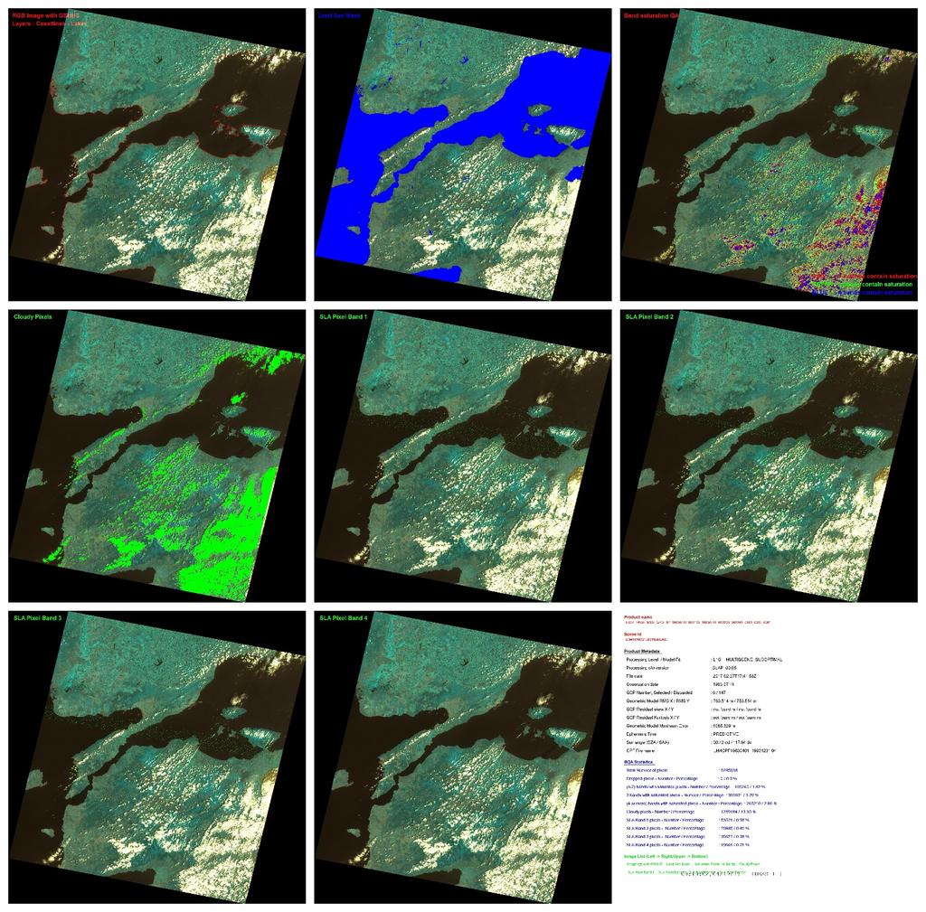
19 BQA Pixel based information Scan Line Artefacts (SLA) hot spot, sticky bit Dropped lines Saturation Cloud cover Land / Water mask (ESA CCI product) Bit Value USGS Landsat Collection 1 Description ESA MSS Description 0 1 Designated Fill Designated Fill 1 2 Dropped Pixel Dropped Pixel 2 4 Radiometric 3 8 Saturation Radiometric Saturation 4 16 Cloud Cloud 5 32 Cloud Confidence Cloud Confidence Cloud Shadow Confidence Snow / Ice Confidence Cloud Shadow Confidence Snow / Ice Confidence Scan Line Anomaly (SLA) striping / saturation / hotspot / sticky bit Land / Water mask 19
20

21
22 Insight on the archive Analyze temporal coverage of MSS data for specific countries and considering winter and summer period. EU countries covered since the beginning and almost uniformly. Improvements of the coverage of Eastern Countries (Russian, Kazakstan), Northern Countries (Greenland) and Southern Countries (Western part of Africa ) and Islands. 22


23 23
24 24
25 Proof of concept Outline : Several multi temporal applications for which the use of MSS is valuable have been selected in order to demonstrate that data are fit for application purposes. Thematic Area : Phenology Monitoring, Snow / Ice Monitoring, and urban mapping 25
, grass land (Case 2).")
 Case 2 Study site: The")
26 Phenology : Monitoring of Forest (Case 1) / Grass land (Case 2) Approach : Collect a large MSS, TM, LS08 dataset over forest (Case 1), grass land (Case 2). Apply preprocessing, compute NDVI, perform analysis. Case 1 Study site: Bouconne, Buzet Forest around Toulouse (France) Case 2 Study site: The northern coast of East Anglia, (Eastern North Sea coastline of the United Kingdom) 26
27 Phenology Case 1 Results 1/2 27
28 Phenology Case 1 Results 2/2 Agreements between measurements from two different dataset, involving different measurements. Good shape of the average NDVI with more uncertainties at growing season Outliers removed because of In some cases, very small NDI values on MSS1 / MSS2 1985/1987 Long and in late freezed period One LS08 NDVI (Summer 2016) very high compared to previous ones (0.76) 28
29 Phenology Case 2 Results Landsat 5 data, MSS ( )/ TM ( ) Strong Discrepancies between TM and MSS MSS NDVI appears lower than TM and its temporal variability is important. Variability of MSS calibration is an issue, strong changes are mostly due to weather conditions and year to year seasonal shift. 29
30 Snow/Ice : Equilibrium Line Approach : Collect a MSS, Sentinel 2 data acquired (if possible) in Autumn, Segment Equilibrium line, and assess if MSS data radiometry allows to perform this task. 30


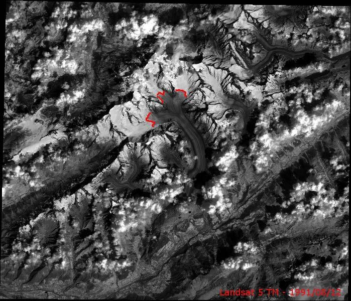

31 Snow/Ice : Equilibrium Line 31
32 Snow/Ice : Equilibrium Line Results : MSS2/3/4/5 data allows to search this line at large scale Problem is more the period of data, two observation per year and sometimes cloudy. Dataset, MSS 5, can be densified with TM data. Landsat and S2 Results are in agreement. 32
33 Urban Mapping Approach : Collect a large MSS, TM, LS08 dataset over Toulouse City, more than 100 products, create a movie and assess visually urban dynamic Evaluate if details seen with MSS are sufficiently well defined to characterized changes. Results : No geometric correction applied, except for one product The registration of images are with 1.5 pixels if one consider all the series. See next slides. 33
34 Conclusions The ESA MSS data reprocessing project has been presented. The work brings new knowledge regarding our data stored at ESA. We hope it will benefit to a larger user audience. The same approach has been successfully applied for TM / ETM+ data. However, MSS required very careful / specific treatment in term of product development, product processing and quality control. The reprocessing of MSS data will take place by the end of Summer. 34
35 LS08 Processing and QC at ESA LS08 data Near Real time service proposed by ESA IDEAS+ QC activities performed on a monthly basis: Absolute Geolocation Accuracy Assessment; Multi temporal Geolocation Accuracy Assessment ; Short term geolocation stability data from the same path, observed on the same date are analysed Cross track variability different regions in the image located at several locations in the field view are compared Band to band Geometric Registration Accuracy Assessment; Radiometric Calibration stability over PICS; Statistical comparison between results of the two different ROIs is systematically performed Influence of terrain content is better assessed. BQA band inspection, Image Artefact Analysis and Thermal band inspection. Monthly Performance Report is issued every month and 35
 Bulk processing Repatriation (consolidated L0 & processed L1) Data consolidation L0 QC")
 Tool verification L1 QC Expert support Project")
36 Team Introductions expert Product Reprocessing Scalable Service Project management Data collection (L0 & AUX) Bulk processing Repatriation (consolidated L0 & processed L1) Data consolidation L0 QC Processor integration Instrument Data quality Evaluation and Analysis Service Processor development Systematic QC tool development (AMALFI) Tool verification L1 QC Expert support Project management
37 Data Access ESA s TPM online dissemination service: ESA Landsat 8 Web Portal: ESA Landsat 8 RealTime Viewer 37


38 This image cannot currently be displayed. Thank you for your attention
39 MSS v3.05 IPF Enhancements Calibration Coefficients Estimate LS05 MSS Calibration parameters over Libya 4 PICS applying cross calibration methodology; Validation on a small dataset observed over Libya 4 and in Iceland; Validation on a large dataset observed in all available PICS test sites; Define most affected WRS scenes in the archive broken down into Desert / Ice-snow regions; For these scenes apply new calibration parameters depending for L1 product generation depending on the season (Summer / Winter) 39
40 ECMWF Water vapor Ozone MSS Spectral Band Definition MSS Observation date and geometrie SIMULATED Top of Atmosphere Measurement Radiative Transfer Code (6s) Oversampled LANDSAT 8 Surface Reflectance Measurements MSS Top of Atmosphere Measurement Data Collected for all ROIs Statistical Comparison Calibration Parameters 40

41 MSS v3.05 IPF Enhancements Calibration Coefficients Libya 4 dataset, RED band Author: SEBASTIEN 41


42 MSS v3.05 IPF Enhancements Calibration Coefficients Libya 4 dataset, NIR1 band CPF patch with changes on Min / Max Radiance Latest CPF patch with changes on Min / Max Radiance and 42 Radiometric Calibration Gain
43 Timeline of Events IDEAS+ activity X-PReSS activity TM/ETM+ L1 ACTIVITIES QUALITY CONTROL TM MPS TM MTI Processing TM BSK Processing MTI Delta ETM+ KSE & MPS ETM+ MTI Regeneration of TM GCP AUX Mid-orbit gap analysis MSS L1 ACTIVITIES v3.04 development & verification MSS stress test (v3.03) Processing QC of full MSS archive v3.05 specification definition & design CPF definition & preliminary verification QC tool update AUX SV generation IPF, QC Tool & CPF verification 43
44 MSS v3.05 IPF Enhancements Calibration Coefficients Iceland Results (snow ice) Percentage of saturated pixels for 3 L1 scenes: Green and Red bands Little reduction of saturation Percentage of saturated pixels for 3 L1 scenes: NIR1 and NIR2 bands Significant improvement for NIR1 44
45 MSS v3.05 IPF Enhancements Calibration Coefficients LS05 MSS CPF files have been updated (applicable for a restricted number of WRS scenes): LM5CPF _ LM5CPF _ Revised Band 2 and Band 3 scaling parameters improve product quality Minimum Radiance and Maximum Radiance have been changed for the RED and NIR1 bands The NIR1 calibration gain of the first CPF has been changed Validation on a extended PICS dataset is now on going Regarding methodology, improvements have been tested by considering varying AOTs value depending on the location in the scene, it increases the accuracy of the results 45
46 BQA Additional logging To ensure full traceability between L0 and L1 (log files not available to users) Full resolution jpeg QuickLook In addition to existing medium res. png Quality Assurance Band (BQA) 16 bit GeoTIFF file for all MSS L1 products Sticky bit correction (TBC) Updated L1 product quality classification Updated calibration coefficient To reduce L1-introduced saturation Geometry To provide more details on GCPs To give greater confidence on accuracy Bit Value USGS Landsat Collection 1 Description ESA MSS Description 0 1 Designated Fill Designated Fill 1 2 Dropped Pixel Dropped Pixel 2 4 Radiometric 3 8 Saturation Radiometric Saturation 4 16 Cloud Cloud 5 32 Cloud Confidence Cloud Confidence Cloud Shadow Confidence Snow / Ice Confidence Cloud Shadow Confidence Snow / Ice Confidence Scan Line Anomaly (SLA) striping / saturation / hotspot / sticky bit Land / Water mask
47 MSS v3.05 IPF Enhancements Geometry The nominal geometrical correction procedure of the ESA Landsat processor is to: Automatically locate GCPs from a GCP database within a scene by normalized absolute image correlation in orthorectified map geometry. Model the distortion with an affine transform using a weighted, constrained, least squares fit with iterative outlier removal. Apply the correction using DEM to produce L1T product We call this single scene refinement 47
48 MSS v3.05 IPF Enhancements Geometry The overall accuracy of the single scene fit is estimated considering: The number of found GCPs Their correlation SNR Their distribution over the scene The chi squared goodness of fit The number of outliers 48
49 MSS v3.05 IPF Enhancements Geometry If the estimated accuracy obtained by single scene fit is not considered sufficient to produce an optimal quality L1T, several back up possibilities are available: Label the L1T as suboptimal Use multiscene refinement to produce L1T Produce a L1G+ correcting geometry without DEM (not used for ETM) Produce a L1Gt using DEM and nominal geometry (used only for ETM) Produce a L1G with no geometric correction or DEM 49
50 MSS v3.05 IPF Enhancements Geometry In multiscene refinement: The affine transform distortions estimated by single scene fitting are used to estimate 2 distortions at 2 points along track per scene in a common SOM projection geometry. The distortions for the whole pass are modelled using a weighted, constrained, least squares fit with iterative outlier removal. A generic fourier series is now used to model the variation of distortions along track. 50
51 MSS v3.05 IPF Enhancements Geometry The main enhancements w.r.t. v3.04 (delta MSS processor) are: Stronger distortion constraints are used for single scene fitting (this can avoid the production of very distorted scenes and help outlier removal in difficult situations) Use general Fourier series instead of b-splines for multiscene fitting (this works much better in particular when distortions have to be extrapolated for several scenes at start and end of pass) Add accuracy estimates which also consider distribution of used GCPs or multiscene refinement in MTL annotations, for L1G+ products also. Add other statistics to MTL annotations regarding GCP distribution Use another orbit propagator (works better for longer propagations) 51

52 MSS v3.05 IPF Enhancements Geometry Example of multiscene fit with estimated errors (L0 pass with several scenes covered by clouds) Note that for MSS the attitude information are missing 52
53 MSS v3.05 IPF Enhancements Geometry The multiscene refinement accuracy for each scene is estimated considering: The number of used single scene distortion estimates Their input single scene estimated accuracies Their distribution over the scene The chi squared goodness of fit The number of outliers The position of the scene within the pass 53
54 MSS v3.05 IPF Enhancements Geometry New MTL fields per product level Level L1G/L1GT L1G+/L1T L1G+/L1T Fit type None Multi Single MODEL_FIT_TYPE x x x GEOMETRIC_MAX_ERR x x GROUND_CONTROL_POINT_DISCARDED x x NUMBER_EMPTY_GROUND_CONTROL_POINT_WINDOWS x GROUND_CONTROL_POINT_WINDOW<n> x GROUND_CONTROL_POINT_RESIDUALS_SKEW_X x GROUND_CONTROL_POINT_RESIDUALS_SKEW_Y x GROUND_CONTROL_POINT_RESIDUALS_KURTOSIS_X x GROUND_CONTROL_POINT_RESIDUALS_KURTOSIS_Y x 54
Bulk-processing of ESA s Unique Landsat Archive
 Bulk-processing of ESA s Unique Landsat Archive Landsat MSS, TM and ETM+ archive (1974 2011) Biasutti, Roberto - Gascon, Ferran - Fischer, Peggy - Hoersch, Bianca (1) Pinori, Sabrina - Paciucci, Alessandra
Landsat 8, Level 1 Product Performance Cyclic Report July 2016
 Landsat 8, Level 1 Product Performance Cyclic Report July 2016 Author(s) : Sébastien Saunier (IDEAS+, Telespazio VEGA) Amy Northrop (IDEAS+, Telespazio VEGA) IDEAS+-VEG-OQC-REP-2647 Issue July 2016 1 September
LANDSAT 8 Level 1 Product Performance
 Réf: IDEAS-TN-10-CyclicReport LANDSAT 8 Level 1 Product Performance Cyclic Report Month/Year: May 2015 Date: 25/05/2015 Issue/Rev:1/0 1. Scope of this document On May 30, 2013, data from the Landsat 8
Landsat Products, Algorithms and Processing (MSS, TM & ETM+)
") Landsat Products, Algorithms and Processing Author(s) : Sébastien Saunier (Magellium) Amy Northrop, Sam Lavender (Telespazio VEGA UK) IDEAS+-MAG-SRV-REP-2266 7 May 2015 Page 2 of 13 AMENDMENT RECORD SHEET
Landsat Products, Algorithms and Processing Author(s) : Sébastien Saunier (Magellium) Amy Northrop, Sam Lavender (Telespazio VEGA UK) IDEAS+-MAG-SRV-REP-2266 7 May 2015 Page 2 of 13 AMENDMENT RECORD SHEET
Landsat 8, Level 1 Product Performance Cyclic Report January 2017
 Landsat 8, Level 1 Product Performance Cyclic Report January 2017 Author(s) : Sébastien Saunier (IDEAS+, Telespazio VEGA) Amy Northrop (IDEAS+, Telespazio VEGA) IDEAS+-VEG-OQC-REP-2647 Issue January 2017
Landsat 8, Level 1 Product Performance Cyclic Report November 2016
 Landsat 8, Level 1 Product Performance Cyclic Report November 2016 Author(s) : Sébastien Saunier (IDEAS+, Telespazio VEGA) Amy Northrop (IDEAS+, Telespazio VEGA) IDEAS+-VEG-OQC-REP-2647 Issue November
Landsat 8, Level 1 Product Performance Cyclic Report February 2017
 Landsat 8, Level 1 Product Performance Cyclic Report February 2017 Author(s) : Sébastien Saunier (IDEAS+, Telespazio VEGA) Amy Northrop (IDEAS+, Telespazio VEGA) IDEAS+-VEG-OQC-REP-2647 Issue February
Landsat 8, Level 1 Product Performance Cyclic Report August 2017
 Landsat 8, Level 1 Product Performance Cyclic Report August 2017 Author(s) : Sébastien Saunier (IDEAS+, Telespazio VEGA) Amy Beaton (IDEAS+, Telespazio VEGA) IDEAS+-VEG-OQC-REP-2647 Issue August 2017 21
SDCG-5 Session 2. Landsat 7/8 status and 2013 Implementation Plan (Element 1)
") Session 2 Landsat 7/8 status and 2013 Implementation Plan (Element 1) Gene Fosnight Mission Landsat Launch and commissioning Landsat 7 Operational: since 15 April 1999 Expected life time:; anticipate decommissioning
Session 2 Landsat 7/8 status and 2013 Implementation Plan (Element 1) Gene Fosnight Mission Landsat Launch and commissioning Landsat 7 Operational: since 15 April 1999 Expected life time:; anticipate decommissioning
USGS Welcome. 38 th CEOS Working Group on Calibration and Validation Plenary (WGCV-38)
") Landsat 5 USGS Welcome Prepared for 38 th CEOS Working Group on Calibration and Validation Plenary (WGCV-38) Presenter Tom Cecere International Liaison USGS Land Remote Sensing Program Elephant Butte Reservoir
Landsat 5 USGS Welcome Prepared for 38 th CEOS Working Group on Calibration and Validation Plenary (WGCV-38) Presenter Tom Cecere International Liaison USGS Land Remote Sensing Program Elephant Butte Reservoir
Sentinel-2 Products and Algorithms
 Sentinel-2 Products and Algorithms Ferran Gascon (Sentinel-2 Data Quality Manager) Workshop Preparations for Sentinel 2 in Europe, Oslo 26 November 2014 Sentinel-2 Mission Mission Overview Products and
WGISS-42 USGS Agency Report
 WGISS-42 USGS Agency Report U.S. Department of the Interior U.S. Geological Survey Kristi Kline USGS EROS Center Major Activities Landsat Archive/Distribution Changes Land Change Monitoring, Assessment,
TPM Meeting #2. 10 th November 2016 ESRIN, Frascati
 TPM Meeting #2 10 th November 2016 ESRIN, Frascati Ruby Mannan Massimo Cardaci Sébastien Saunier Amy Northrop Sam Lavender Task 1, Mission Science Ops Co-ordinator (Telespazio VEGA) Task 2, IPF & Tools
Lesson 3: Working with Landsat Data
 Lesson 3: Working with Landsat Data Lesson Description The Landsat Program is the longest-running and most extensive collection of satellite imagery for Earth. These datasets are global in scale, continuously
TEMPORAL ANALYSIS OF MULTI EPOCH LANDSAT GEOCOVER IMAGES IN ZONGULDAK TESTFIELD
 TEMPORAL ANALYSIS OF MULTI EPOCH LANDSAT GEOCOVER IMAGES IN ZONGULDAK TESTFIELD Şahin, H. a*, Oruç, M. a, Büyüksalih, G. a a Zonguldak Karaelmas University, Zonguldak, Turkey - (sahin@karaelmas.edu.tr,
The availability of cloud free Landsat TM and ETM+ land observations and implications for global Landsat data production
 14475 The availability of cloud free Landsat TM and ETM+ land observations and implications for global Landsat data production *V. Kovalskyy, D. Roy (South Dakota State University) SUMMARY The NASA funded
Comprehensive Vicarious Calibration and Characterization of a Small Satellite Constellation Using the Specular Array Calibration (SPARC) Method
 Method") This document does not contain technology or Technical Data controlled under either the U.S. International Traffic in Arms Regulations or the U.S. Export Administration Regulations. Comprehensive Vicarious
This document does not contain technology or Technical Data controlled under either the U.S. International Traffic in Arms Regulations or the U.S. Export Administration Regulations. Comprehensive Vicarious
Moderate Resolution Sensor Interoperability Framework
 Moderate Resolution Sensor Interoperability Framework Version 1.0 August 2017 Moderate Resolution Sensor Interoperability Framework Initiative Version 1.0; 30 August 2017 MRI Team: Gene Fosnight (USGS),
Satellite data processing and analysis: Examples and practical considerations
 Satellite data processing and analysis: Examples and practical considerations Dániel Kristóf Ottó Petrik, Róbert Pataki, András Kolesár International LCLUC Regional Science Meeting in Central Europe Sopron,
PLANET SURFACE REFLECTANCE PRODUCT
 PLANET SURFACE REFLECTANCE PRODUCT FEBRUARY 2018 SUPPORT@PLANET.COM PLANET.COM VERSION 1.0 TABLE OF CONTENTS 3 Product Description 3 Atmospheric Correction Methodology 5 Product Limitations 6 Product Assessment
MRLC 2001 IMAGE PREPROCESSING PROCEDURE
 MRLC 2001 IMAGE PREPROCESSING PROCEDURE The core dataset of the MRLC 2001 database consists of Landsat 7 ETM+ images. Image selection is based on vegetation greenness profiles defined by a multi-year normalized
RADIOMETRIC CALIBRATION
 1 RADIOMETRIC CALIBRATION Lecture 10 Digital Image Data 2 Digital data are matrices of digital numbers (DNs) There is one layer (or matrix) for each satellite band Each DN corresponds to one pixel 3 Digital
MUSCATE : Operational Production Atmospheric
 MUSCATE : Operational Production Atmospheric Corrections and Monthly Composites Sentinel-2 Marc Leroy 1, Olivier Hagolle 2, Mireille Huc 2, Mohamed Kadiri 2, Gérard Dedieu 2, Joëlle Donadieu 1, Philippe
VALIDATION OF THE CLOUD AND CLOUD SHADOW ASSESSMENT SYSTEM FOR LANDSAT IMAGERY (CASA-L VERSION 1.3)
") GDA Corp. VALIDATION OF THE CLOUD AND CLOUD SHADOW ASSESSMENT SYSTEM FOR LANDSAT IMAGERY (-L VERSION 1.3) GDA Corp. has developed an innovative system for Cloud And cloud Shadow Assessment () in Landsat
GDA Corp. VALIDATION OF THE CLOUD AND CLOUD SHADOW ASSESSMENT SYSTEM FOR LANDSAT IMAGERY (-L VERSION 1.3) GDA Corp. has developed an innovative system for Cloud And cloud Shadow Assessment () in Landsat
NORMALIZING ASTER DATA USING MODIS PRODUCTS FOR LAND COVER CLASSIFICATION
 NORMALIZING ASTER DATA USING MODIS PRODUCTS FOR LAND COVER CLASSIFICATION F. Gao a, b, *, J. G. Masek a a Biospheric Sciences Branch, NASA Goddard Space Flight Center, Greenbelt, MD 20771, USA b Earth
NON-PHOTOGRAPHIC SYSTEMS: Multispectral Scanners Medium and coarse resolution sensor comparisons: Landsat, SPOT, AVHRR and MODIS
 NON-PHOTOGRAPHIC SYSTEMS: Multispectral Scanners Medium and coarse resolution sensor comparisons: Landsat, SPOT, AVHRR and MODIS CLASSIFICATION OF NONPHOTOGRAPHIC REMOTE SENSORS PASSIVE ACTIVE DIGITAL
Remote sensing image correction
 Remote sensing image correction Introductory readings remote sensing http://www.microimages.com/documentation/tutorials/introrse.pdf 1 Preprocessing Digital Image Processing of satellite images can be
PLANET IMAGERY PRODUCT SPECIFICATION: PLANETSCOPE & RAPIDEYE
 PLANET IMAGERY PRODUCT SPECIFICATION: PLANETSCOPE & RAPIDEYE LAST UPDATED OCTOBER 2016 SALES@PLANET.COM PLANET.COM Table of Contents LIST OF FIGURES 3 LIST OF TABLES 3 GLOSSARY 5 1. OVERVIEW OF DOCUMENT
Landsat 8. Snabba leveranser av bilder till användarna. Lars-Åke Edgardh. tisdag 9 april 13
 Landsat 8 Snabba leveranser av bilder till användarna Lars-Åke Edgardh Keystone A single system for: Many sensors Many types of clients Hides the complexity of sensors. Specialised on: Services High volume
ENMAP RADIOMETRIC INFLIGHT CALIBRATION, POST-LAUNCH PRODUCT VALIDATION, AND INSTRUMENT CHARACTERIZATION ACTIVITIES
 ENMAP RADIOMETRIC INFLIGHT CALIBRATION, POST-LAUNCH PRODUCT VALIDATION, AND INSTRUMENT CHARACTERIZATION ACTIVITIES A. Hollstein1, C. Rogass1, K. Segl1, L. Guanter1, M. Bachmann2, T. Storch2, R. Müller2,
remote sensing? What are the remote sensing principles behind these Definition
 Introduction to remote sensing: Content (1/2) Definition: photogrammetry and remote sensing (PRS) Radiation sources: solar radiation (passive optical RS) earth emission (passive microwave or thermal infrared
PLANET IMAGERY PRODUCT SPECIFICATION: PLANETSCOPE & RAPIDEYE
 PLANET IMAGERY PRODUCT SPECIFICATION: PLANETSCOPE & RAPIDEYE LAST UPDATED FEBRUARY 2017 SALES@PLANET.COM PLANET.COM Table of Contents LIST OF FIGURES 3 LIST OF TABLES 3 GLOSSARY 5 1. OVERVIEW OF DOCUMENT
Evaluation of FLAASH atmospheric correction. Note. Note no SAMBA/10/12. Authors. Øystein Rudjord and Øivind Due Trier
 Evaluation of FLAASH atmospheric correction Note Note no Authors SAMBA/10/12 Øystein Rudjord and Øivind Due Trier Date 16 February 2012 Norsk Regnesentral Norsk Regnesentral (Norwegian Computing Center,
An Introduction to Remote Sensing & GIS. Introduction
 An Introduction to Remote Sensing & GIS Introduction Remote sensing is the measurement of object properties on Earth s surface using data acquired from aircraft and satellites. It attempts to measure something
STM Product Evolution for Processing Baseline 2.24
 PREPARATION AND OPERATIONS OF THE MISSION PERFORMANCE CENTRE (MPC) FOR THE COPERNICUS SENTINEL-3 MISSION Contract: 4000111836/14/I-LG Customer: ESA Document Contract No.: 4000111836/14/I-LG Project: PREPARATION
Global Land Survey 2005
 Global Land Survey 2005 Jeff Masek, Shannon Franks, Terry Arvidson NASA GSFC Rachel Headley, Steve Covington USGS EROS April, 2008 1 Global Land Survey (GLS 2005) Follow-on to the GeoCover orthorectified
GEOMETRIC RECTIFICATION OF EUROPEAN HISTORICAL ARCHIVES OF LANDSAT 1-3 MSS IMAGERY
 GEOMETRIC RECTIFICATION OF EUROPEAN HISTORICAL ARCHIVES OF LANDSAT -3 MSS IMAGERY Torbjörn Westin Satellus AB P.O.Box 427, SE-74 Solna, Sweden tw@ssc.se KEYWORDS: Landsat, MSS, rectification, orbital model
Update on Landsat Program and Landsat Data Continuity Mission
 Update on Landsat Program and Landsat Data Continuity Mission Dr. Jeffrey Masek LDCM Deputy Project Scientist NASA GSFC, Code 923 November 21, 2002 Draft LDCM Implementation Phase RFP Overview Page 1 Celebrate!
ASSESSMENT BY ESA OF GCOS CLIMATE MONITORING PRINCIPLES FOR GMES
 Prepared by ESA Agenda Item: III.5 Discussed in WG3 ASSESSMENT BY ESA OF GCOS CLIMATE MONITORING PRINCIPLES FOR GMES The ESA Sentinel missions are being designed for the GMES services, with special emphasis
ASTER GDEM Readme File ASTER GDEM Version 1
 I. Introduction ASTER GDEM Readme File ASTER GDEM Version 1 The Advanced Spaceborne Thermal Emission and Reflection Radiometer (ASTER) Global Digital Elevation Model (GDEM) was developed jointly by the
Sources of Geographic Information
 Sources of Geographic Information Data properties: Spatial data, i.e. data that are associated with geographic locations Data format: digital (analog data for traditional paper maps) Data Inputs: sampled
29 th Annual Louisiana RS/GIS Workshop April 23, 2013 Cajundome Convention Center Lafayette, Louisiana
 Landsat Data Continuity Mission 29 th Annual Louisiana RS/GIS Workshop April 23, 2013 Cajundome Convention Center Lafayette, Louisiana http://landsat.usgs.gov/index.php# Landsat 5 Sets Guinness World Record
DESIS Applications & Processing Extracted from Teledyne & DLR Presentations to JACIE April 14, Ray Perkins, Teledyne Brown Engineering
 DESIS Applications & Processing Extracted from Teledyne & DLR Presentations to JACIE April 14, 2016 Ray Perkins, Teledyne Brown Engineering 1 Presentation Agenda Imaging Spectroscopy Applications of DESIS
Remote sensing in archaeology from optical to lidar. Krištof Oštir ModeLTER Scientific Research Centre of the Slovenian Academy of Sciences and Arts
 Remote sensing in archaeology from optical to lidar Krištof Oštir ModeLTER Scientific Research Centre of the Slovenian Academy of Sciences and Arts Introduction Optical remote sensing Systems Search for
National Aeronautics and Space Administration. Landsat Update. Jeff Masek, NASA GSFC Jim Irons, NASA GSFC. April 3, 2012 LCLUC Meeting.
 National Aeronautics and Space Administration Landsat Update Jeff Masek, NASA GSFC Jim Irons, NASA GSFC April 3, 2012 LCLUC Meeting www.nasa.gov Agenda Landsat-5/7 Update LDCM / Landsat-8 Mission Status
Lecture 6: Multispectral Earth Resource Satellites. The University at Albany Fall 2018 Geography and Planning
 Lecture 6: Multispectral Earth Resource Satellites The University at Albany Fall 2018 Geography and Planning Outline SPOT program and other moderate resolution systems High resolution satellite systems
SENTINEL-2 LEVEL 1 PRODUCTS AND IMAGE PROCESSING PERFORMANCES
 SENTINEL-2 LEVEL 1 PRODUCTS AND IMAGE PROCESSING PERFORMANCES S. J Baillarin a, *, A. Meygret a, C. Dechoz a, B. Petrucci a, S. Lacherade a, T. Tremas a, C. Isola b, P. Martimort b, F. Spoto b a CNES,
Inter comparison of Terra and Aqua MODIS Reflective Solar Bands Using Suomi NPP VIIRS
 Inter comparison of Terra and Aqua Reflective Solar Bands Using Suomi NPP VIIRS Slawomir Blonski, * Changyong Cao, Sirish Uprety, ** and Xi Shao * NOAA NESDIS Center for Satellite Applications and Research
REMOTE SENSING. Topic 10 Fundamentals of Digital Multispectral Remote Sensing MULTISPECTRAL SCANNERS MULTISPECTRAL SCANNERS
 REMOTE SENSING Topic 10 Fundamentals of Digital Multispectral Remote Sensing Chapter 5: Lillesand and Keifer Chapter 6: Avery and Berlin MULTISPECTRAL SCANNERS Record EMR in a number of discrete portions
University of Texas at San Antonio EES 5053 Term Project CORRELATION BETWEEN NDVI AND SURFACE TEMPERATURES USING LANDSAT ETM + IMAGERY NEWFEL MAZARI
 University of Texas at San Antonio EES 5053 Term Project CORRELATION BETWEEN NDVI AND SURFACE TEMPERATURES USING LANDSAT ETM + IMAGERY NEWFEL MAZARI Introduction and Objectives The present study is a correlation
9/12/2011. Training Course Remote Sensing Basic Theory & Image Processing Methods September 2011
 Training Course Remote Sensing Basic Theory & Image Processing Methods 19 23 September 2011 Popular Remote Sensing Sensors & their Selection Michiel Damen (September 2011) damen@itc.nl 1 Overview Low resolution
S2 MPC Data Quality Report Ref. S2-PDGS-MPC-DQR
 S2 MPC Data Quality Report Ref. S2-PDGS-MPC-DQR 2/36 Authors Table Name Company Responsibility Date Signature Written by S. Clerc & MPC Team ARGANS Technical Manager 08/02/2018 Verified by O. Devignot
Aral Sea profile Selection of area 24 February April May 1998
 250 km Aral Sea profile 1960 1960 1985 1986 1987 1988 1989 1990 1991 1992 1993 1994 1995 1996 1997 1998 2010? Selection of area Area of interest Kzyl-Orda Dried seabed 185 km Syrdarya river Aral Sea Salt
Planet Labs Inc 2017 Page 2
 SKYSAT IMAGERY PRODUCT SPECIFICATION: ORTHO SCENE LAST UPDATED JUNE 2017 SALES@PLANET.COM PLANET.COM Disclaimer This document is designed as a general guideline for customers interested in acquiring Planet
Spectral Signatures. Vegetation. 40 Soil. Water WAVELENGTH (microns)
") Spectral Signatures % REFLECTANCE VISIBLE NEAR INFRARED Vegetation Soil Water.5. WAVELENGTH (microns). Spectral Reflectance of Urban Materials 5 Parking Lot 5 (5=5%) Reflectance 5 5 5 5 5 Wavelength (nm)
Spectral Signatures % REFLECTANCE VISIBLE NEAR INFRARED Vegetation Soil Water.5. WAVELENGTH (microns). Spectral Reflectance of Urban Materials 5 Parking Lot 5 (5=5%) Reflectance 5 5 5 5 5 Wavelength (nm)
Landsat 8 and Sentinel 2 higher order products: input to S2DUP. Chris Justice (UMD) Curtis Woodcock (BU), Martin Claverie (UMD/GSFC)
 Curtis Woodcock (BU), Martin Claverie (UMD/GSFC)") Landsat 8 and Sentinel 2 higher order products: input to S2DUP Chris Justice (UMD) Curtis Woodcock (BU), Martin Claverie (UMD/GSFC) MODIS Land Products Energy Balance Product Suite Surface Reflectance
Landsat 8 and Sentinel 2 higher order products: input to S2DUP Chris Justice (UMD) Curtis Woodcock (BU), Martin Claverie (UMD/GSFC) MODIS Land Products Energy Balance Product Suite Surface Reflectance
A SYNERGETIC USE OF REMOTE-SENSED DATA TO ASSESS THE EVOLUTION OF BURNT AREA BY WILDFIRES IN PORTUGAL
 A SYNERGETIC USE OF REMOTE-SENSED DATA TO ASSESS THE EVOLUTION OF BURNT AREA BY WILDFIRES IN PORTUGAL Teresa J. Calado and Carlos C. DaCamara CGUL, Faculty of Sciences, University of Lisbon, Campo Grande,
Digital database creation of historical Remote Sensing Satellite data from Film Archives A case study
 Digital database creation of historical Remote Sensing Satellite data from Film Archives A case study N.Ganesh Kumar +, E.Venkateswarlu # Product Quality Control, Data Processing Area, NRSA, Hyderabad.
S2 MPC L1C Data Quality Report Ref. S2-PDGS-MPC-DQR
 S2 MPC L1C Data Quality Report Ref. S2-PDGS-MPC-DQR 2/43 Authors Table Name Company Responsibility Date Signature Written by S. Clerc & MPC Team ARGANS Technical Manager 07/11/2018 Verified by O. Devignot
S3 Product Notice SLSTR
 S3 Product Notice SLSTR Mission Sensor Product S3-A SLSTR Level 2 Land Surface Temperature Product Notice ID S3A.PN-SLSTR-L2L.02 Issue/Rev Date 05/07/2017 Version 1.0 Preparation Approval This Product
Introduction to Remote Sensing Fundamentals of Satellite Remote Sensing. Mads Olander Rasmussen
 Introduction to Remote Sensing Fundamentals of Satellite Remote Sensing Mads Olander Rasmussen (mora@dhi-gras.com) 01. Introduction to Remote Sensing DHI What is remote sensing? the art, science, and technology
Geometric Quality Assessment of CBERS-2. Julio d Alge Ricardo Cartaxo Guaraci Erthal
 Geometric Quality Assessment of CBERS-2 Julio d Alge Ricardo Cartaxo Guaraci Erthal Contents Monitoring CBERS-2 scene centers Satellite orbit control Band-to-band registration accuracy Detection and control
Introduction of Satellite Remote Sensing
 Introduction of Satellite Remote Sensing Spatial Resolution (Pixel size) Spectral Resolution (Bands) Resolutions of Remote Sensing 1. Spatial (what area and how detailed) 2. Spectral (what colors bands)
EnMAP Environmental Mapping and Analysis Program
 EnMAP Environmental Mapping and Analysis Program www.enmap.org Mathias Schneider Mission Objectives Regular provision of high-quality calibrated hyperspectral data Precise measurement of ecosystem parameters
Copernicus Introduction Lisbon, Portugal 13 th & 14 th February 2014
 Copernicus Introduction Lisbon, Portugal 13 th & 14 th February 2014 Contents Introduction GMES Copernicus Six thematic areas Infrastructure Space data An introduction to Remote Sensing In-situ data Applications
Geometric Validation of Hyperion Data at Coleambally Irrigation Area
 Geometric Validation of Hyperion Data at Coleambally Irrigation Area Tim McVicar, Tom Van Niel, David Jupp CSIRO, Australia Jay Pearlman, and Pamela Barry TRW, USA Background RICE SOYBEANS The Coleambally
Suomi NPP VIIRS Calibration/ Validation Progress Update
 Suomi NPP VIIRS Calibration/ Validation Progress Update C. Cao 1, Q. Liu 2, S. Blonski 2, X. Shao 2, and S. Uprety 3 1 NOAA/NESDIS Center for Satellite Applications and Research 2 ESSIC, University of
Satellite Remote Sensing: Earth System Observations
 Satellite Remote Sensing: Earth System Observations Land surface Water Atmosphere Climate Ecosystems 1 EOS (Earth Observing System) Develop an understanding of the total Earth system, and the effects of
Application of GIS to Fast Track Planning and Monitoring of Development Agenda
 Application of GIS to Fast Track Planning and Monitoring of Development Agenda Radiometric, Atmospheric & Geometric Preprocessing of Optical Remote Sensing 13 17 June 2018 Outline 1. Why pre-process remotely
Compact High Resolution Imaging Spectrometer (CHRIS) siraelectro-optics
 siraelectro-optics") Compact High Resolution Imaging Spectrometer (CHRIS) Mike Cutter (Mike_Cutter@siraeo.co.uk) Summary CHRIS Instrument Design Instrument Specification & Performance Operating Modes Calibration Plan Data
Compact High Resolution Imaging Spectrometer (CHRIS) Mike Cutter (Mike_Cutter@siraeo.co.uk) Summary CHRIS Instrument Design Instrument Specification & Performance Operating Modes Calibration Plan Data
The studies began when the Tiros satellites (1960) provided man s first synoptic view of the Earth s weather systems.
 provided man s first synoptic view of the Earth s weather systems.") Remote sensing of the Earth from orbital altitudes was recognized in the mid-1960 s as a potential technique for obtaining information important for the effective use and conservation of natural resources.
Remote sensing of the Earth from orbital altitudes was recognized in the mid-1960 s as a potential technique for obtaining information important for the effective use and conservation of natural resources.
Using IRS Products to Recover 7ETM + Defective Images
 American Journal of Applied Sciences 5 (6): 618-625, 2008 ISSN 1546-9239 2008 Science Publications Using IRS Products to Recover 7ETM + Defective Images 1 Mobasheri Mohammad Reza and 2 Sadeghi Naeini Ali
Remote Sensing Exam 2 Study Guide
 Remote Sensing Exam 2 Study Guide Resolution Analog to digital Instantaneous field of view (IFOV) f ( cone angle of optical system ) Everything in that area contributes to spectral response mixels Sampling
Sensor resolutions from space: the tension between temporal, spectral, spatial and swath. David Bruce UniSA and ISU
 Sensor resolutions from space: the tension between temporal, spectral, spatial and swath David Bruce UniSA and ISU 1 Presentation aims 1. Briefly summarize the different types of satellite image resolutions
SEN3APP Stakeholder Workshop, Helsinki Yrjö Rauste/VTT Kaj Andersson/VTT Eija Parmes/VTT
 Optical Products from Sentinel-2 and Suomi- NPP/VIIRS SEN3APP Stakeholder Workshop, Helsinki 19.11.2015 Yrjö Rauste/VTT Kaj Andersson/VTT Eija Parmes/VTT Structure of Presentation High-resolution data
MONITORING OF FOREST DAMAGE CAUSED BY GYPSY MOTH IN HUNGARY USING ENVISAT MERIS DATA ( )
") MONITORING OF FOREST DAMAGE CAUSED BY GYPSY MOTH IN HUNGARY USING ENVISAT DATA (2005-2006) G. Nádor, I. László, Zs. Suba, G. Csornai Remote Sensing Centre, Institute of Geodesy Cartography and Remote Sensing
MONITORING OF FOREST DAMAGE CAUSED BY GYPSY MOTH IN HUNGARY USING ENVISAT DATA (2005-2006) G. Nádor, I. László, Zs. Suba, G. Csornai Remote Sensing Centre, Institute of Geodesy Cartography and Remote Sensing
Lecture 13: Remotely Sensed Geospatial Data
 Lecture 13: Remotely Sensed Geospatial Data A. The Electromagnetic Spectrum: The electromagnetic spectrum (Figure 1) indicates the different forms of radiation (or simply stated light) emitted by nature.
First inflight results of Pleiades-1A innovative methods for optical calibration
 ICSO 2012 / Imagers and Radiometers First inflight results of Pleiades-1A innovative methods for optical calibration Philippe KUBIK Octobre 9 th, 2012 philippe.kubik@cnes.fr Titre du document + date Arial
CanImage. (Landsat 7 Orthoimages at the 1: Scale) Standards and Specifications Edition 1.0
 Standards and Specifications Edition 1.0") CanImage (Landsat 7 Orthoimages at the 1:50 000 Scale) Standards and Specifications Edition 1.0 Centre for Topographic Information Customer Support Group 2144 King Street West, Suite 010 Sherbrooke, QC
CanImage (Landsat 7 Orthoimages at the 1:50 000 Scale) Standards and Specifications Edition 1.0 Centre for Topographic Information Customer Support Group 2144 King Street West, Suite 010 Sherbrooke, QC
PROGRESS IN ADDRESSING SCIENCE GOALS FOR GLACIER OBSERVATIONS BY MEANS OF SAR. Frank Paul & Thomas Nagler
 PROGRESS IN ADDRESSING SCIENCE GOALS FOR GLACIER OBSERVATIONS BY MEANS OF SAR Frank Paul & Thomas Nagler SAR Coordination Working Group Meeting, 13/11/2016 Observed glacier products and sensors Product
Landsat 8 Operational Land Imager On-Orbit Geometric Calibration and Performance
 Remote Sens. 2014, 6, 11127-11152; doi:10.3390/rs61111127 Article OPEN ACCESS remote sensing ISSN 2072-4292 www.mdpi.com/journal/remotesensing Landsat 8 Operational Land Imager On-Orbit Geometric Calibration
PLANET IMAGERY PRODUCT SPECIFICATIONS PLANET.COM
 PLANET IMAGERY PRODUCT SPECIFICATIONS SUPPORT@PLANET.COM PLANET.COM LAST UPDATED JANUARY 2018 TABLE OF CONTENTS LIST OF FIGURES 3 LIST OF TABLES 4 GLOSSARY 5 1. OVERVIEW OF DOCUMENT 7 1.1 Company Overview
RADIOMETRIC CHARACTERIZATION AND PERFORMANCE ASSESSMENT OF THE ALI USING BULK TRENDED DATA
 RADIOMETRIC CHARACTERIZATION AND PERFORMANCE ASSESSMENT OF THE ALI USING BULK TRENDED DATA Tim Ruggles*, Imaging Engineer Dennis Helder*, Director Image Processing Laboratory, Department of Electrical
Using Ground Targets for Sensor On orbit Calibration Support
 EOS Using Ground Targets for Sensor On orbit Calibration Support X. Xiong, A. Angal, A. Wu, and T. Choi MODIS Characterization Support Team (MCST), NASA/GSFC G. Chander SGT/USGS EROS CEOS Libya 4 Workshop,
Preparing for the exploitation of Sentinel-2 data for agriculture monitoring. JACQUES Damien, DEFOURNY Pierre UCL-Geomatics Lab 2 octobre 2013
 Preparing for the exploitation of Sentinel-2 data for agriculture monitoring JACQUES Damien, DEFOURNY Pierre UCL-Geomatics Lab 2 octobre 2013 Agriculture monitoring, why? - Growing speculation on food
PROGRESS IN ADDRESSING SCIENCE GOALS FOR GLACIER OBSERVATIONS BY MEANS OF SAR
 PROGRESS IN ADDRESSING SCIENCE GOALS FOR GLACIER OBSERVATIONS BY MEANS OF SAR Frank Paul, Thomas Nagler, Dana Floricioiu, et al. PSTG, 13/9/2016 Panmah, Karakoram Observed glacier products and sensors
Landsat Data Continuity Mission: Overview and Status
 National Aeronautics and Space Administration Landsat Data Continuity Mission: Overview and Status Brian Markham, LDCM Cal/Val Manager March 29, 2011 JACIE www.nasa.gov www.usgs.gov Mission Objectives
San Diego State University Department of Geography, San Diego, CA. USA b. University of California, Department of Geography, Santa Barbara, CA.
 1 Plurimondi, VII, No 14: 1-9 Land Cover/Land Use Change analysis using multispatial resolution data and object-based image analysis Sory Toure a Douglas Stow a Lloyd Coulter a Avery Sandborn c David Lopez-Carr
Image transformations
 Image transformations Digital Numbers may be composed of three elements: Atmospheric interference (e.g. haze) ATCOR Illumination (angle of reflection) - transforms Albedo (surface cover) Image transformations
Recent developments in Deep Blue satellite aerosol data products from NASA GSFC
 Recent developments in Deep Blue satellite aerosol data products from NASA GSFC Andrew M. Sayer, N. Christina Hsu (PI), Corey Bettenhausen, Myeong-Jae Jeong Climate & Radiation Laboratory, NASA Goddard
Using Freely Available. Remote Sensing to Create a More Powerful GIS
 Using Freely Available Government Data and Remote Sensing to Create a More Powerful GIS All rights reserved. ENVI, E3De, IAS, and IDL are trademarks of Exelis, Inc. All other marks are the property of
The Landsat Legacy: Monitoring a Changing Earth. U.S. Department of the Interior U.S. Geological Survey
 The Landsat Legacy: Monitoring a Changing Earth U.S. Department of the Interior U.S. Geological Survey Tom Loveland March 17, 2001 Landsat Science Mission Change is occurring at rates unprecedented in
QWG4 RADIOMETRIC CALIBRATION: STATUS. Sindy Sterckx, Stefan Adriaensen, Wouter Dierckx
 QWG4 RADIOMETRIC CALIBRATION: STATUS Sindy Sterckx, Stefan Adriaensen, Wouter Dierckx Outline VNIR strips Stability Interband and absolute verification SWIR strips Stability Updates Dark current, bad pixels
Introduction to Remote Sensing
 Introduction to Remote Sensing Spatial, spectral, temporal resolutions Image display alternatives Vegetation Indices Image classifications Image change detections Accuracy assessment Satellites & Air-Photos
Introduction to image processing for remote sensing: Practical examples
 Università degli studi di Roma Tor Vergata Corso di Telerilevamento e Diagnostica Elettromagnetica Anno accademico 2010/2011 Introduction to image processing for remote sensing: Practical examples Dr.
NASA Missions and Products: Update. Garik Gutman, LCLUC Program Manager NASA Headquarters Washington, DC
 NASA Missions and Products: Update Garik Gutman, LCLUC Program Manager NASA Headquarters Washington, DC 1 JPSS-2 (NOAA) SLI-TBD Formulation in 2015 RBI OMPS-Limb [[TSIS-2]] [[TCTE]] Land Monitoring at
Activity Data (AD) Monitoring in the frame of REDD+ MRV
 Monitoring in the frame of REDD+ MRV") Activity Data (AD) Monitoring in the frame of REDD+ MRV Preliminary comments REDD+ is sustainable low emissions, high carbon rural development Monitoring efforts should support this effort Challenges Diversity
Activity Data (AD) Monitoring in the frame of REDD+ MRV Preliminary comments REDD+ is sustainable low emissions, high carbon rural development Monitoring efforts should support this effort Challenges Diversity
(Presented by Jeppesen) Summary
 Summary") International Civil Aviation Organization SAM/IG/6-IP/06 South American Regional Office 24/09/10 Sixth Workshop/Meeting of the SAM Implementation Group (SAM/IG/6) - Regional Project RLA/06/901 Lima, Peru,
International Civil Aviation Organization SAM/IG/6-IP/06 South American Regional Office 24/09/10 Sixth Workshop/Meeting of the SAM Implementation Group (SAM/IG/6) - Regional Project RLA/06/901 Lima, Peru,
Microwave Sensors Subgroup (MSSG) Report
 Report") Microwave Sensors Subgroup (MSSG) Report Feb 17-20, 2014, ESA ESRIN, Frascati, Italy DONG, Xiaolong, MSSG Chair National Space Science Center Chinese Academy of Sciences (MiRS,NSSC,CAS) Email: dongxiaolong@mirslab.cn
Microwave Sensors Subgroup (MSSG) Report Feb 17-20, 2014, ESA ESRIN, Frascati, Italy DONG, Xiaolong, MSSG Chair National Space Science Center Chinese Academy of Sciences (MiRS,NSSC,CAS) Email: dongxiaolong@mirslab.cn
Feedback on Level-1 data from CCI projects
 Feedback on Level-1 data from CCI projects R. Hollmann, Cloud_cci Background Following this years CMUG meeting & Science Leader discussion on Level 1 CCI projects ingest a lot of level 1 satellite data