2010 Census TIGER/Line Shapefiles
|
|
|
- Myles McCarthy
- 6 years ago
- Views:
Transcription
1 R 2010 Census TIGER/Line Shapefiles Technical Documentation 2010 U.S. Department of Commerce Geography Division U.S. Census Bureau
2 Acknowledgments 2010 Census TIGER/Line Shapefiles Technical Documentation was produced by the Geography Division under the guidance of Timothy Trainor, Division Chief and Michael Ratcliffe, Assistant Division Chief for Geocartographic Products and Criteria. The 2010 Census TIGER/Line Shapefiles Technical Documentation and specifications for the 2010 TIGER/Line Shapefiles were compiled by staff in the Geographic Products Branch under the guidance of Jennifer Holland, the Geographic Areas Branch under the guidance of Jamie Rosenson, and Andrea Johnson the Assistant Division Chief for Geographic Operations, with special thanks to staff in the Geographic Standards and Criteria Branch, Linear Features Branch, National/State Geographic Partnership Branch, and Spatial Products Software Branch for their input. Programming for this version of the TIGER/Line Shapefiles was done by the Spatial Products Software Branch under the guidance of Ricardo Ruiz, Branch Chief. Programming related to the website was done by staff in the Spatial Products Software Branch, the Workflow Control Branch, and the Website Services and Coordination Staff of the Systems Support Division. Special thanks to the Core Update Software Branch and Geographic Process and Quality Management Branch of the Geography Division for their role in the quality control. This version of the technical documentation was released on March 21, 2011.
3 R 2010 Census TIGER/Line Shapefiles Technical Documentation 2010 Issued March, 2011 U.S DEPARTMENT OF C O MMERCE BUREA U OF THE S U CENS U.S. Department of Commerce Gary Locke, Secretary Economics and Statistics Administration Rebecca M. Blank, Under Secretary for Economic Affairs U.S. Census Bureau Robert M. Groves, Director
![SUGGESTED CITATION FILES: 2010 Census TIGER/Line Shapefiles [machine-readable data files]/ prepared by the U.S. Census Bureau, 2011 TECHNICAL DOCUMENTATION: 2010 Census TIGER/Line Shapefiles Technical Documentation/prepared by the U.](/docs-images/72/66899063/images/4-0.jpg "S. Census Bureau, 2011 U.S. CENSUS BUREAU Robert M. Groves Director Thomas L. Mesenbourg, Deputy Director and Chief Operating Officer Arnold A.")

4 SUGGESTED CITATION FILES: 2010 Census TIGER/Line Shapefiles [machine-readable data files]/ prepared by the U.S. Census Bureau, 2011 TECHNICAL DOCUMENTATION: 2010 Census TIGER/Line Shapefiles Technical Documentation/prepared by the U.S. Census Bureau, 2011 U.S. CENSUS BUREAU Robert M. Groves Director Thomas L. Mesenbourg, Deputy Director and Chief Operating Officer Arnold A. Jackson, Associate Director for Decennial Census Daniel H. Weinberg, Assistant Director for ACS and Decennial Census GEOGRAPHY DIVISION Timothy F. Trainor, Division Chief Deirdre Dalpiaz Bishop Assistant Division Chief/ Geographic Operations Advisor Andrea G. Johnson Assistant Division Chief for Geographic Operations Gerard Boudriault Assistant Division Chief for Production and Control Atri Kalluri Assistant Division Chief for Spatial Data Systems and Database Management Vacant Assistant Division Chief for Address Software Michael R. Ratcliffe Assistant Division Chief for Geocartographic Products and Criteria Leslie Godwin Assistant Division Chief for Geographic Program Management
5 Table of Contents 1 Introduction What are TIGER/Line Shapefiles? History of TIGER/Line Files and Shapefiles TIGER/Line Shapefile Legal Disclaimers About the 2010 Census TIGER/Line Shapefiles What are the 2010 Census TIGER/Line Shapefiles? Geographic Features and Boundaries Available in the 2010 Census TIGER/Line Shapefiles New Features in the 2010 Census TIGER/Line Shapefiles Boundary Changes Spatial Accuracy of Linear Features Initial Sources MAF/TIGER Accuracy Improvement Project Coordinates Codes for Geographic Entities Structure and Format Shapefile Vintages Census Geography Census 2000 Geography Table 1: 2010 Census Shapefile and Relationship File Availability by Vintage Organization of the Files Table 2: 2010 Census Shapefile Layers Availability by Parent Geography File Naming Conventions Datum (GCS NAD 83) Metadata Shapefile Attribute Terms Glossary i
6 4.1 Edge Face Feature Feature Identifier Feature Indicators Geographic Corridors GCSEFLG MAF/TIGER Feature Class Code (MTFCC) Node OFFSET OFFSETL OFFSETR Relationship file Shapefile TFID TFIDL TFIDN TLID TNID TNIDF TNIDT Geographic Shapefile Concepts Overview American Indian Areas Alaska Native Regional Corporations Alaska Native Regional Corporation (ANRC) Shapefile Record Layout (2010 Census) Alaska Native Regional Corporation (ANRC) Shapefile Record Layout (Census 2000) American Indian, Alaska Native, and Native Hawaiian (AIANNH) Areas American Indian/Alaska Native/Native Hawaiian (AIANNH) Area Nation-based Shapefile Record Layout (2010 Census) American Indian/Alaska Native/Native Hawaiian Area (AIANNH) Nation-based Shapefile Record Layout (Census 2000) American Indian/Alaska Native/Native Hawaiian Area (AIANNH) State-based Shapefile (2010 Census) American Indian/Alaska Native/Native Hawaiian Area (AIANNH) State-based Shapefile (Census 2000) American Indian Tribal Subdivisions American Indian Tribal Subdivision (AITS) American Indian area-based Shapefile Record Layout (2010 Census) American Indian Tribal Subdivision (AITS) American Indian area-based Shapefile Record Layout (Census 2000) ii
7 American Indian Tribal Subdivision (AITS) Nation-based Shapefile Record Layout (2010 Census) American Indian Tribal Subdivision (AITS) Nation-based Shapefile Record Layout (Census 2000) American Indian Tribal Subdivision (AITS) State-based Shapefile Record Layout (2010 Census) American Indian Tribal Subdivision (AITS) State-based Shapefile Record Layout (Census 2000) Tribal Block Group Tribal Block Group American Indian area-based Shapefile (2010 Census) Tribal Block Group American Indian area-based Shapefile (Census 2000) Tribal Block Group Nation-based Shapefile (2010 Census) Tribal Block Group Nation-based Shapefile (Census 2000) Tribal Census Tract Tribal Census Tract American Indian area-based Shapefile (2010 Census) Tribal Census Tract American Indian area-based Shapefile (Census 2000) Tribal Census Tract Nation-based Shapefile (2010 Census) Tribal Census Tract Nation-based Shapefile (Census 2000) Blocks (Census Block) Block State-based Shapefile Record Layout (2010 Census) Block State-based Shapefile Record Layout (Census 2000) Block County-based Shapefile Record Layout (2010 Census) Block County-based Shapefile Record Layout (Census 2000) Block Groups Block Group State-based Shapefile Record Layout (2010 Census) Block Group State-based Shapefile Record Layout (Census 2000) Block Group County-based Shapefile Record Layout (2010 Census) Block Group County-based Shapefile Record Layout (Census 2000) Census Tracts Census Tract State-based Shapefile Record Layout (2010 Census) Census Tract State-based Shapefile Record Layout (Census 2000) Census Tract County-based Shapefile Record Layout (2010 Census) Census Tract County-based Shapefile Record Layout (Census 2000) Congressional Districts th Congressional District Nation-based Shapefile Record Layout th Congressional District Nation-based Shapefile Record Layout th Congressional District State-based Shapefile Record Layout th Congressional District State-based Shapefile Record Layout Consolidated Cities Consolidated City Shapefile Record Layout (2010 Census) iii
8 5.6.2 Consolidated City Shapefile Record Layout (Census 2000) Counties and Equivalent Entities County and Equivalent Entity Nation-based Shapefile Record Layout (2010 Census) County and Equivalent Entity Nation-based Shapefile Record Layout (Census 2000) County and Equivalent Entity State-based Shapefile Record Layout (2010 Census) County and Equivalent Entity State-based Shapefile Record Layout (Census 2000) County Subdivisions County Subdivision State-based Shapefile Record Layout (2010 Census) County Subdivision State-based Shapefile Record Layout (Census 2000) County Subdivision County-based Shapefile Record Layout (2010 Census) County Subdivision County-based Shapefile Record Layout (Census 2000) Hydrography Area Hydrography County-based Shapefile Record Layout Linear Hydrography County-based Shapefile Record Layout Landmarks (Area and Point) Area Landmark County-based Shapefile Record Layout Point Landmark County-based Shapefile Record Layout Linear Features All Lines All Lines County-based Shapefile Record Layout Roads Primary Roads Nation-based Shapefile Record Layout Primary and Secondary Roads State-based Shapefile Record Layout All Roads County-based Shapefile Record Layout Railroads Railroads Nation-based Shapefile Record Layout Metropolitan and Micropolitan Statistical Areas and Related Statistical Areas Combined New England City and Town Area (CNECTA) Nation-based Shapefile Record Layout (2010 Census) Combined New England City and Town Area (CNECTA) State-based Shapefile (2010 Census) Combined Statistical Area (CSA) Nation-based Shapefile Record Layout (2010 Census) Combined Statistical Area (CSA) State-based Shapefile Record Layout (2010 Census) Metropolitan Division Nation-based Shapefile Record Layout (2010 Census) Metropolitan Division State-based Shapefile Record Layout (2010 Census) Metropolitan Statistical Area/Micropolitan Statistical Area (CBSA) Nation-based Shapefile Record Layout (2010 Census) Metropolitan/Micropolitan Statistical Area (CBSA) State-based Shapefile Record Layout (2010 Census) iv
9 New England City and Town Area (NECTA) Shapefile National Record Layout (2010 Census) New England City and Town Area (NECTA) State-based Shapefile Record Layout (2010 Census) New England City and Town Area (NECTA) Division Shapefile National Record Layout (2010 Census) New England City and Town Area (NECTA) Division State-based Shapefile Record Layout (2010 Census) Military Installations Military Installation Nation-based Shapefile Record Layout Military Installation State-based Shapefile Record Layout Places Place State-based Shapefile Record Layout (2010 Census) Place State-based Shapefile Record Layout (Census 2000) School Districts (Elementary, Secondary, and Unified) Elementary School District Shapefile Record Layout (2010 Census) Elementary School District Shapefile Record Layout (Census 2000) Secondary School District Shapefile Record Layout (2010 Census) Secondary School District Shapefile Record Layout (Census 2000) Unified School District Shapefile Record Layout (2010 Census) Unified School District Shapefile Record Layout (Census 2000) States and Equivalent Entities State and Equivalent Entity Nation-based Shapefile Record Layout (2010 Census) State and Equivalent Entity Nation-based Shapefile Record Layout (Census 2000) State and Equivalent Entity State-based Shapefile Record Layout (2010 Census) State and Equivalent Entity State-based Shapefile Record Layout (Census 2000) State Legislative Districts (Upper and Lower Chambers) State Legislative District Lower Chamber (SLDL) Shapefile Record Layout (2010 Census) State Legislative District Lower Chamber (SLDL) Shapefile Record Layout (Census 2000) State Legislative District Upper Chamber (SLDU) Shapefile Record Layout (2010 Census) State Legislative District Upper Chamber (SLDU) Shapefile Record Layout (Census 2000) Subminor Civil Divisions Subminor Civil Division Shapefile Record Layout (2010 Census) Subbarrio Shapefile Record Layout (Census 2000) Topological Faces (Polygons with All Geocodes) Topological Faces (Polygons with All Geocodes) Shapefile Record Layout Urban Growth Areas Urban Growth Area (UGA) Shapefile Record Layout (2010 Census) v
10 Urban Growth Area (UGA) Shapefile Record Layout (Census 2000) Voting Districts Voting District (VTD) Shapefile Record Layout (2010 Census) Voting District (VTD) Shapefile Record Layout (Census 2000) ZIP Code Tabulation Areas (5-digit) Digit ZIP Code Tabulation Area (ZCTA5) Nation-based Shapefile Record Layout (2010 Census) Digit ZIP Code Tabulation Area (ZCTA5) Nation-based Shapefile Record Layout (Census 2000) Relationship File Concept Overview Address Ranges Address Ranges Relationship File Record Layout Address Range-Feature Name Relationships Address Range-Feature Name County-based Relationship File Record Layout Feature Names Feature Names Relationship File Record Layout Other Identifiers Other Identifiers Relationship File Record Layout Topological Faces-Area Landmark Relationships Topological Faces-Area Landmark Relationship File Record Layout Topological Faces-Area Hydrography Relationships Topological Faces-Area Hydrography Relationship File Record Layout Topological Faces-Military Installation Relationships Topological Faces Military Installation Nation-based Relationship File A. Complete Record Layout B. Pseudo-School Districts C. Feature Name Directionals D. Feature Name Qualifiers E. Feature Name Types F. MAF/TIGER Feature Class Code (MTFCC) Definitions vi
11 1 Introduction 1.1 What are TIGER/Line Shapefiles? The TIGER/Line Shapefiles are extracts of selected geographic and cartographic information from the U.S. Census Bureau's Master Address File/Topologically Integrated Geographic Encoding and Referencing (MAF/TIGER) database. The shapefiles include information for the fifty states, the District of Columbia, and Puerto Rico. They do not contain any sensitive data, areas used for administering censuses and surveys, or attributes used only in internal processing. The TIGER/Line Shapefiles are designed for use with geographic information system (GIS) software. The MAF/TIGER database contains geographic linear, areal, and point features such as streets, railroads, rivers, lakes, and landmarks (airports, schools, etc.). Geographic entity boundaries from the MAF/TIGER database are represented in the files, as well as the polygons that make up the legal and statistical geographic areas for which the Census Bureau tabulates data. The MAF/TIGER database also contains attribute information about these features, such as names, the type of feature, address ranges for most streets, the geographic relationship to other features, and other related information. Relationship of the TIGER/Line Shapefiles to Census Statistical Data What makes the TIGER/Line Shapefiles particularly valuable in the GIS environment, and to the data user community, is the ability to directly link the geographic areas to data from the 2010 Census, the American Community Survey, the Economic Census, and other survey and population estimates data. The TIGER/Line Shapefiles include Federal Information Processing Series (FIPS) codes and the American National Standards Institute (ANSI) codes, where available. Census Bureau codes, or locally produced codes to uniquely identify geographic areas for the nation s legal and statistical entities also are included for selected geographic areas. TIGER/Line Shapefiles do not include demographic data from surveys and censuses, but the two can be joined by using the geographic entity codes found in both the shapefiles and the demographic data. The inclusion of a set of unique key codes allows for geographic entities to be easily matched and linked with data from censuses and surveys. Data from many of the Census Bureau s surveys and censuses, including the geographic codes needed to join to the TIGER/Line Shapefiles, can be obtained from American FactFinder ( 1.2 History of TIGER/Line Files and Shapefiles The TIGER/Line files were initially released in 1989 and provided the first nationwide street centerline coverage of the United States, Puerto Rico, and the Island Areas in a series of ASCII format fixed tables or record types. These ASCII TIGER/Line files could be converted to a GIS compatible format with the use of a translator. Periodic versions were released throughout the 1990s in ASCII format. For Census 2000, several versions of TIGER/Line files were released from 2000 to 2006 in the ASCII TIGER/Line file format to support the Census 2000 data tabulations. Beginning with the 2007 version, the format of the TIGER/Line files changed from the ASCII TIGER/Line file format to shapefile. Where to locate the TIGER/Line Files and Shapefiles TIGER/Line Shapefiles (2007 and beyond) All versions of the shapefiles are available from the Census Bureau s website at Census 2000 TIGER/Line files The Census 2000 versions, the 108th Congressional District version, and the 2006 second edition of the TIGER/Line files in ASCII format are available on the TIGER website at 1-1
12 Pre-2000 TIGER/Line files A limited supply of the 1992 TIGER/Line files are available from the U.S. Census Bureau by calling (301) 763-INFO. The 1992 version provides a link between 1980 and 1990 Census geography. Currently no other versions of the pre-2000 TIGER/Line files are available. For copies of additional versions of TIGER/Line files that are no longer available from the Census Bureau, users should contact their local state data centers or university libraries. 1.3 TIGER/Line Shapefile Legal Disclaimers No warranty, expressed or implied, is made with regard to the accuracy of the data in the TIGER/Line Shapefiles, and no liability is assumed by the United States Government in general, or the Census Bureau specifically, as to the positional or attribute accuracy of the data. The boundary information in the TIGER/Line Shapefiles is for statistical data collection and tabulation purposes only. Their depiction and designation for statistical purposes does not constitute a determination of jurisdictional authority or rights of ownership or entitlement and they are not legal land descriptions. TIGER and TIGER/Line are registered trademarks of the Census Bureau and ZCTA is a trademark of the Census Bureau. As such, these names cannot be used as or within the proprietary product names of any commercial product including or otherwise relevant to Census Bureau data, and may only be used to refer to the nature of such product. The Census Bureau requests that any repackaging of the TIGER/Line Shapefile data, documentation, and other files accompanying it for distribution include a conspicuously placed statement to this effect on the product's cover, the first page of the website, or elsewhere of comparable visibility. Further, Census Bureau trademarks, when used in reference to the nature of the product, should be accompanied by the (registered) symbol or symbol, where convenient. Questions and Contact Information Questions about TIGER/Line Shapefiles obtained from the Census Bureau can be directed to the Geographic Products Branch, Geography Division, U.S. Census Bureau. The TIGER/Line Shapefiles are offered to the public free of charge through the Census Bureau s website. If you obtain the TIGER/Line Shapefiles from a third party, we recommend you contact that vendor for assistance as it is possible that they made changes to the files that we are unaware of or unable to support. Geographic Products Branch Geography Division, U.S. Census Bureau 4600 Silver Hill Road Washington, DC Office: (301) geo.tiger@census.gov 1-2
13 2 About the 2010 Census TIGER/Line Shapefiles 2.1 What are the 2010 Census TIGER/Line Shapefiles? The shapefiles represent geographic linear features such as roads, railroads, rivers, and non-visible legal boundaries; selected point features such as hospitals; and areal features such as parks as of January 1, The files also contain attribute information about these features, such as names, the type of feature, address ranges for most streets, the geographic relationship to other features, and other related information. The 2010 Redistricting Shapefiles include data for all 50 states, the District of Columbia and the Commonwealth of Puerto Rico. The 2010 Census TIGER/Line Shapefiles contain 2010 Census geography and Census 2000 geography. 2.2 Geographic Features and Boundaries Available in the 2010 Census TIGER/Line Shapefiles The 2010 Census TIGER/Line Shapefiles contain the geographic extent and boundaries of both legal and statistical entities. A legal entity is a geographic entity whose boundaries, name, origin, and area description result from charters, laws, treaties, or other administrative or governmental action. A statistical entity is any geographic entity or combination of entities identified and defined solely for the tabulation and presentation of data. Statistical entity boundaries are not legally defined and the entities have no governmental standing. The legal entities included in these shapefiles are: American Indian off-reservation trust lands American Indian reservations (both federally and state-recognized) American Indian tribal subdivisions (within legal American Indian areas) Congressional districts Counties and equivalent entities (except census areas in Alaska) Hawaiian home lands Incorporated places Minor civil divisions (MCDs, legal county subdivisions) School districts (elementary, secondary, and unified) States and equivalent entities State legislative districts (upper and lower chambers) Subminor civil divisions (sub-mcds, in Puerto Rico only) Urban growth areas (in Oregon and Washington) Voting districts The statistical entities included in these shapefiles are: American Indian/Alaska Native statistical areas Alaska Native village statistical areas Tribal designated statistical areas Oklahoma tribal statistical areas State designated tribal statistical areas American Indian Tribal Subdivisions (within Oklahoma tribal statistical areas) Block groups Census areas (statistical county equivalents in Alaska) Census blocks Census county divisions (CCDs), census subareas (in Alaska), and unorganized territories (statistical county subdivisions) Census designated places Census tracts Metropolitan and Micropolitan Statistical Areas and Related Statistical Areas 5-digit ZIP Code Tabulation Areas (ZCTAs)* * will be released in summer 2011 supplemental release 2-3
14 2.3 New Features in the 2010 Census TIGER/Line Shapefiles The 2010 Census TIGER/Line shapefiles include numerous feature updates and data corrections which were obtained during the 2010 Census field operations. Most notably, there have been extensive updates to the address ranges in the 50 States and the District of Columbia. The Census Bureau used the addresses and their locations collected during 2010 Census operations to update and build new potential address ranges. The results of these updates should improve address geocoding rates and quality. 2.4 Boundary Changes The 2010 Census TIGER/Line Shapefile boundaries for some legal areas represent those that were collected as part of the Census Bureau's 2010 Boundary and Annexation Survey (BAS). The boundaries of all federally recognized American Indian Reservations and off-reservation trust lands, tribal subdivisions, states and equivalent entities, all counties and equivalent entities, all minor civil divisions (MCDs), all consolidated cities, and all incorporated places generally are those that were legally in effect as of January 1, Included in this vintage are legal changes to boundaries, such as annexations or deannexations of territory Census TIGER/Line Shapefile boundaries for elementary, secondary, and unified school districts are collected through a survey of state school authorities under the auspices of the U.S. Department of Education s National Center for Education Statistics and are current as of the school year. Since the release of the Census 2000 versions of the TIGER/Line files, the Census Bureau has shifted and reshaped most linear features, including those that form legal or statistical area boundaries. The shape and area of the Census 2000 geographic entities portrayed in the 2010 Census TIGER/Line Shapefile may differ from their portrayal in the Census 2000 versions of the TIGER/Line files, but the inventory of Census 2000 tabulation entities remains the same. For more information about the Boundary Annexation Survey (BAS), please visit: Spatial Accuracy of Linear Features In order to maintain a current geographic database from which to extract the TIGER/Line Shapefiles, the Census Bureau uses various internal and external processes to update the MAF/TIGER database. While it has made a reasonable and systematic attempt to gather the most recent information available about the features this file portrays, the Census Bureau cautions users that the files are no more complete than the source documents used in their compilation, the vintage of those source documents, and the translation of the information on those source documents. 2.6 Initial Sources The initial sources used to create the Census TIGER database, predecessor to the MAF/TIGER database, were the U.S. Geological Survey (USGS) 1:100,000-scale Digital Line Graph (DLG), USGS 1:24,000-scale quadrangles, the Census Bureau s 1980 geographic base files (GBF/DIME-Files), and a variety of miscellaneous maps for selected areas outside the contiguous 48 states. The DLG coverage is extensive, albeit of variable currency, and comprises most of the rural, small city, and suburban area of the TIGER/Line Shapefiles. GBF/DIME-File coverage areas were updated through 1987 with the manual translation of features from the most recent aerial photography available to the Census Bureau. The Census Bureau added the enumerator updates compiled during the 1990 and Census 2000 census operations to the TIGER database. The updates came from map annotations made by enumerators as they attempted to locate living quarters by traversing every street feature in their assignment area. The Census Bureau digitized the enumerator updates directly into the TIGER database without geodetic controls or the use of aerial photography to confirm the features locational accuracy. The Census Bureau also made other corrections and updates to the Census TIGER database that was supplied by local participants in various Census Bureau programs. Local updates originated from map reviews by local government officials or their liaisons and local participants in Census Bureau programs. Maps were sent to participants for use in various census programs, and some maps were returned with 2-4
15 update annotations and corrections. The Census Bureau generally added the updates to the Census TIGER database without extensive checks. Changes made by local officials did not have geodetic control. 2.7 MAF/TIGER Accuracy Improvement Project The Census Bureau began a multi-year project called the MAF/TIGER Accuracy Improvement Project (MTAIP) in 2002 to realign and update street features in our geographic database. The project realigned and updated the street features by county (or equivalent entity). The MTAIP was completed in State, tribal, county, and local governments submitted over 2,000 files, which the Census Bureau used as sources to perform the realignment and feature update work. In other counties, contractors performed the work using recently obtained imagery and/or driving the counties with Global Positioning System (GPS) enhanced mapping equipment. Though all counties have been through the process, additional realignment and corrections will continue to take place for some counties. As part of this project, the Census Bureau used GPS coordinates at street centerline intersections to test and report the Circular Error 95 (CE95) horizontal spatial accuracy of source files obtained to: 1) realign street features in the MAF/TIGER database, and 2) test and report the horizontal spatial accuracy of the street features in the TIGER/Line Shapefiles. The test compared a survey-grade GPS coordinate to its associated street centerline intersection in the update source. The test was based upon an independent collection of GPS coordinates for a random sample of right-angle street intersections from a centerline file that meet certain criteria. The points were referred to as the sample points and were gathered through a private contractor. Since the collection method used survey-quality GPS-based field techniques, the resulting control points were considered "ground truth" against which the intersection coordinates were compared. The test verified that the spatial accuracy of the street network met the Census Bureau's horizontal spatial accuracy standard of CE95 at 7.6 meters (about twenty-five feet) or better. This accuracy standard requires that 95 percent of the time, the distance between the sample control points coordinates and their corresponding street centerline file intersection points not exceed 7.6 meters, i.e., a file point will fall within a radius of 7.6 meters of its corresponding control point. The CE95 can be calculated from the mean and standard deviation by using the formula: mean of differences plus (2.65 times the standard deviation). The CE95 results reported for each file tested were determined using a spreadsheet with an embedded statistical formula. The use and applicability of the spreadsheet and its embedded formula were verified by Census Bureau statisticians. The basis of the calculation used the root mean square error (RMSE). This is the method as stated in the U.S. Government's Federal Geographic Data Committee Standard FGDC-STD , Geospatial Positioning Accuracy Standards, Part 3: National Standard for Spatial Data Accuracy. The results of using this measure of accuracy are in compliance with Federal Spatial Data Accuracy requirements. Address Canvassing In preparation for the 2010 Census, Census employees walked virtually every street in the United States and Puerto Rico with the primary purpose of verifying and updating Census address lists. A second priority was to provide updates to the Census road network. For the first time census workers used handheld computers that captured GPS information and used this technology to improve both the address lists and the census road network. Census field workers had the opportunity to use GPS to add new roads, identify roads for deletion, and rename existing roads. These modifications should be reflected in the 2010 Census TIGER/Line Shapefiles. 2.8 Coordinates Coordinates in the TIGER/Line Shapefiles have six decimal places, but the positional accuracy of these coordinates may not be as great as the six decimal places suggest. The spatial accuracy varies with the source materials used. In areas where the Census Bureau has not realigned street features as part of MTAIP it meets, at best, the established National Map Accuracy standards (approximately + / 50 meters or 167 feet) where 1:100,000-scale maps from the USGS were the source. The Census Bureau cannot specify the spatial accuracy of feature changes added by its field staff or local updates or of features derived from the GBF/DIME-Files or other map or digital sources. Thus, the level of spatial accuracy in the TIGER/Line Shapefiles may not be suitable for high-precision measurement applications such as engineering problems, property transfers, or other uses that might require highly accurate measurements of the earth s surface. No warranty, expressed or implied, is made with regard to the accuracy of these data, and no liability is assumed by the U.S. Government in general or the Census Bureau specifically, as to the spatial or attributes accuracy of the data. 2-5
16 2.9 Codes for Geographic Entities The Census Bureau is currently transitioning from the Federal Information Processing Standards (FIPS) codes issued by the National Institute of Standards and Technology (NIST) to codes issued by the American National Standards Institute (ANSI). In 2005, the NIST publications that define FIPS codes for entities were withdrawn. Many of the former FIPS codes are being reissued, virtually unchanged, by the ANSI. The Census Bureau, citing thirty years of common use, will continue to refer to many of the codes it publishes as FIPS codes with FIPS referring to Federal Information Processing Series. These codes appear in the TIGER/Line Shapefiles in fields such as STATEFP, where FP indicates that the field contains a FIPS code. FIPS codes will continue to serve as the key matching and joining codes, where appropriate, for Census Bureau products. The United States Geological Survey s Geographic Names Information System (GNIS) feature identifier has also been issued as a code standard by the American National Standards Institute. This is a permanent numeric identifier of up to eight digits. The TIGER/Line Shapefiles refers to these eight-character numeric codes as National Standard ANSI codes, and they appear in the files in fields such as STATENS, where NS (for National Standard) indicates that the field contains this type of code. The TIGER/Line documentation also refers to these codes as the ANSI code. The Census Bureau stores the ANSI code as a fixed-width string; the official code is a numeric value without leading zeroes. The ANSI code is only available for 2010 vintage entities. For more information about the FIPS to ANSI transition, please see 2-6
17 3 Structure and Format The 2010 Census TIGER/Line Shapefiles and associated relationship files are offered in a compressed format. One zipped file is available for each layer, with a file extension of.zip. Each zipped shapefile consists of the following five files:.shp the feature geometry.shx the index of the feature geometry.dbf the tabular attribute information.prj the coordinate system information.shp.xml the metadata Each zipped relationship file consists of the following two files:.dbf the tabular attribute information.dbf.xml the metadata 3.1 Shapefile Vintages The 2010 Census TIGER/Line Shapefiles are available in 2010 Census and Census 2000 vintages to enable data users to link geography of the appropriate vintage with the data of the same vintage. For example, if the user wanted to create a map of Census 2000 information, then the user would use the Census 2000 vintage shapefiles. The following is an explanation of the vintages available in the TIGER/Line Shapefiles. Table 1 shows the vintages available for each shapefile or relationship file Census Geography 2010 Census geography is defined as the latest version of the geographic extent of legally defined geographic areas as reported, generally reflecting the boundaries of governmental units in effect as of January 1, 2010, and statistical area boundaries that have been delineated for the 2010 Census. This vintage enables users to see 2010 boundaries of governmental units and statistical areas and they will match the data from the surveys that use 2010 geography, such as the 2010 Census and the 2010 American Community Survey Census 2000 Geography Census 2000 geography is the geographic extent of legally defined geographic areas or statistical areas in effect on January 1, This vintage enables users to work with Census 2000 data using boundaries as they existed in Since 2000, the Census Bureau initiated significant operations to improve the coordinate accuracy of our geographic database-the MAF/TIGER Accuracy Improvement Project or MTAIP. The MTAIP modified the base coordinates of virtually all the features in the database, thus the representation of Census 2000 geography will not match the representation depicted in the Census 2000 TIGER/Line files. The inventory and attributes of the 2000 census geography is, however, unchanged. 3-7
18 Table 1: 2010 Census Shapefile and Relationship File Availability by Vintage File Type Version Census Census Shapefiles Alaska Native Regional Corporation (state-based) American Indian Tribal Subdivision (American Indian area-based) American Indian Tribal Subdivision (nation-based) American Indian Tribal Subdivision (state-based) American Indian/Alaska Native/Native Hawaiian Areas (nation-based) American Indian/Alaska Native/Native Hawaiian Areas (state-based) Block (county-based) Block (state-based) Block Group (county-based) Block Group (state-based) Census Tract (county-based) Census Tract (state-based) Combined New England City and Town Area (nation-based) Combined New England City and Town Area (state-based) Combined Statistical Area (nation-based) Combined Statistical Area (state-based) 108 th Congressional Districts (nation-based) * 108 th Congressional Districts (state-based) * 111 th Congressional Districts (nation-based) * 111 th Congressional Districts (state-based) * Consolidated City (state-based) County and Equivalent (nation-based) County and Equivalent (state-based) County Subdivision (county-based) County Subdivision (state-based) Elementary School District (state-based) Metropolitan Division (nation-based) Metropolitan Division (state-based) Metropolitan/Micropolitan Statistical Area (nation-based) Metropolitan/Micropolitan Statistical Area (state-based) New England City and Town Area (nationbased) New England City and Town Area (statebased) New England City and Town Division (nationbased) 3-8
19 File Type Version Census Census Shapefiles New England City and Town Division (statebased) Place (state-based) Secondary School District (state-based) State and Equivalent (nation-based) State and Equivalent (state-based) State Legislative District-Lower Chamber (state-based) State Legislative District-Upper Chamber (state-based) Subbarrio (county-based) Subminor Civil Division (state-based) Tribal Block Group (American Indian areabased) Tribal Block Group (nation-based) Tribal Census Tract (American Indian areabased) Tribal Census Tract (nation-based) Unified School District (state-based) Urban Growth Area (state-based) *** Voting District (county-based) 5-digit ZIP Code Tabulation Areas (nationbased) **** **** 5-digit ZIP Code Tabulation Areas (statebased) **** **** All Lines (county-based) * All Roads (county-based) ** Area Hydrography (county-based) * Area Landmark (county-based) * Linear Hydrography (county-based) Military Installation (nation-based) Military Installation (state-based) ** Point Landmark (county-based) * Primary Roads (nation-based) ** Primary and Secondary Roads (state-based) Rails (nation-based) Topological Faces (Polygons With All Geocodes) (county-based) ** ** * File Type Version Census Census Relationship Files Address Range-Feature Name (county-based) * Address Ranges (county-based) * Feature Names (county-based) * 3-9
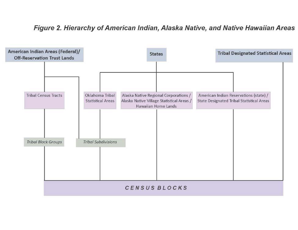
20 File Type Version Census Census Relationship Files Other Identifiers (county-based) * Topological Faces-Area Landmark (county-based) Topological Faces-Area Hydrography (county-based) Topological Faces-Military Installation (nationbased) *not indicated as 2010 Census in title of file; no assigned vintage **not indicated as 2010 Census in title of file; no assigned vintage / new for this version of the TIGER/Line shapefiles *** new for this version of the TIGER/Line shapefiles **** will be released summer 2011 in supplemental update * * * 3.2 Organization of the Files Geographic entities included in the Census Bureau s tabulations are generally hierarchical. The organizational structure of the 2010 Census TIGER/Line Shapefiles is based on this hierarchical framework. Figures 1 and 2 show the progression of geographic areas from the nation to the block level, as well as the American Indian, Alaska Native, and Native Hawaiian areas. Shapefiles are released in one of two types of hierarchical coverage state-based or county-based. Some shapefiles are released in multiple coverages to enable flexibility in downloading files. Descriptions of each coverage type are listed below. Table 2 provides an overview of which file types are available by each hierarchical coverage. American Indian Area-based files each file includes data for one specific American Indian area. Nation-based files each file includes data for the 50 states, the District of Columbia, and Puerto Rico. State-based files each file includes data for one specific state or equivalent. County-based files each file includes data for one specific county or equivalent. 3-10
21 3-11
22 3-12
23 Table 2: 2010 Census Shapefile Layers Availability by Parent Geography Layer Shapefiles Alaska Native Regional Corporation American Indian Area- Based Files Nation- Based Files State- Based Files American Indian Tribal Subdivision American Indian/Alaska Native/Native Hawaiian Areas Block Block Group Census Tract Combined New England City and Town Area Combined Statistical Area 108 th Congressional Districts 111 th Congressional Districts Consolidated City County and Equivalent County Subdivision Elementary School District Metropolitan Division Metropolitan/Micropolitan Statistical Area New England City and Town Area New England City and Town Division Place Secondary School District State and Equivalent State Legislative District-Lower Chamber State Legislative District-Upper Chamber Subbarrio Subminor Civil Division Tribal Block Group Tribal Census Tract Unified School District Urban Growth Area Voting District 5-digit ZIP Code Tabulation Area * * All Lines All Roads Area Hydrography Area Landmark Linear Hydrography Military Installation Point Landmark County- Based Files 3-13
24 Layer Primary Roads Primary and Secondary Roads Rails Topological Faces (Polygons With All Geocodes) Relationship Files Address Range-Feature Name Address Ranges Feature Names Other Identifiers Topological Faces-Area Landmark Topological Faces-Area Hydrography Topological Faces-Military Installations American Indian Area- Based Files Nation- Based Files State- Based Files County- Based Files * will be released in summer 2011 supplemental release 3.3 File Naming Conventions The name of each file is: File Name: tl_2010_<extent>_<layer>.<ext> Where: tl = TIGER/Line 2010 = the version of the files <extent> = parent geography entity ID code (variable length of two to five characters) The entity ID code identifies the geographic extent by specific entity for which the file contains data. It is of variable length depending on the type of file: State-based: 2-digit numeric state FIPS code County-based: 5-digit numeric county FIPS code <layer> = layer tag of variable length The layer tag specifies the type of geography or feature the file contains. If 00 appears at the end of the layer tag, the file contains Census 2000 geography. If 10 appears, the file contains 2010 Census geography. <ext> = the file extension Examples: American Indian Area-based shapefile: Tribal Block Group shapefile for Acoma Pueblo and Off- Reservation Trust Land File Name: tl_2010_0010_tbg10.shp Nation-based shapefile: County and Equivalent shapefile File Name: tl_2010_us_county10.shp State-based shapefile: State and Equivalent shapefile for Maryland File Name: tl_2010_24_state10.shp County-based shapefile: All Lines shapefile for Cayuga County, New York File Name: tl_2010_36011_edges.shp Relationship file: Other Identifiers relationship file for Baltimore County, Maryland File Name: tl_2010_24005_otherid.dbf 3-14
25 3.4 Datum (GCS NAD 83) Each shapefile contains a.prj file that contains the GIS industry standard well-known text (WKT) format to describe the coordinate system/projection/datum information for each shapefile. This enables users to easily import the shapefiles into their local coordinate system. All Census Bureau generated shapefiles are in Global Coordinate System North American Datum of 1983 (GCS NAD83). Each.prj file contains the following: GEOGCS["GCS_North_American_1983",DATUM["D_North_American_1983",SPHEROID["GRS_1980", , ]],PRIMEM["Greenwich",0],UNIT["Degree", ]] 3.5 Metadata Metadata are an organized data file used to capture the basic descriptive characteristics about data. For example, metadata will describe the quality, purpose, spatial extent, and history of a particular dataset. A metadata file in XML (Extensible Markup Language) format is provided along with each shapefile and relationship file. Metadata files associated with shapefiles have the extension.shp.xml, and those associated with relationship files have the extension.dbf.xml. The metadata files comply with Federal Geographic Data Committee (FGDC) standards and can be read in any text editor. Please note that in order to see all the metadata element values, the 'FGDC Classic ' stylesheet must be specified when using ESRI's ArcCatalog. The TIGER/Line Shapefiles metadata contain an entity and attribute information section. The entity and attribute information provide a detailed description of the TIGER/Line Shapefiles and relationship files that include publication date, contact information, and all of the possible valid values for an attribute and each value s meaning. There will be one entity section for each shapefile and relationship file. Users should refer to the metadata files for extensive documentation about the contents of the shapefiles and relationship files. In addition, the All Lines Shapefile also contains a Spatial Metadata Identifier (SMID), which identifies the source of the coordinates for each edge and provides the link between the TIGER/Line Shapefiles and the source and horizontal spatial accuracy information. Refer to the metadata for each county or equivalent entity for information on the source for each edge and the horizontal spatial accuracy, where known. Please note that the horizontal spatial accuracy, where reported, refers only to those edges identified as matched to the source with that accuracy. It is not the spatial accuracy of the TIGER/Line Shapefile as a whole. For more information regarding the All Lines Shapefile please refer to Section 2.5, Spatial Accuracy of Linear Features or Section 5.11, Linear Features. TIGER/Line Shapefiles are a product of the U.S. Census Bureau and as such contain metadata that comply with two standards: the Census Bureau Geospatial Product Metadata Standard (GPMS), and the Federal Geographic Data Committee (FGDC) Content Standard for Digital Geospatial Metadata (CSDGM). The Census Bureau created the Geospatial Product Metadata Standard (GPMS) which includes metadata elements from the FGDC CSDGM and the International Organization for Standardization (ISO) metadata standard: ISO
26 4 Shapefile Attribute Terms Glossary 4.1 Edge A linear object (topological primitive) that extends from a designated start node (From node) and continues to an end node (To node). An edge s geometry can be described by the coordinates of its two nodes, plus possible additional coordinates that are ordered and serve as vertices (or "shape" points) between these nodes. The order of the nodes determines the From-To orientation and left/right sides of the edge. Each edge is uniquely identified by a TLID. 4.2 Face An areal object (topological primitive), bounded by one or more edges. As a topological primitive. a face is not internally subdivided by edges into smaller polygons but may completely surround other faces (island faces). Each face is uniquely identified by a TFID. 4.3 Feature A feature is a unique combination of geometry, feature name, classification and descriptive codes that describe real world objects such as roads, lakes, or buildings. Each edge and face topological primitive may belong to many different features. 4.4 Feature Identifier The linear feature identifier (LINEARID) is a unique ID number for linear features and is used to associate the name and attributes of linear features to their spatial primitives (edges) and address ranges as appropriate. The point landmark identifier (POINTID) is a unique ID number for point landmarks. The area landmark identifier (AREAID) is a unique ID number for area landmarks and is used to associate the name and attributes of area landmarks to their spatial primitives (faces). 4.5 Feature Indicators The All Lines shapefile includes the feature indicators ROADFLG, RAILFLG, HYDROFLG and OLFFLG, which indicate if a given edge belongs to a Road feature, Rail feature, Hydrography feature or other linear feature, respectively. An edge can belong to more than one feature type. 4.6 Geographic Corridors A geographic corridor is a narrow strip of land used to connect parts of legal entities to form a contiguous area. Geographic corridors generally follow the edges of a right-of-way around a linear feature such a road but exclude houses and business addressed to that road. These excluded houses and business belong to the legal entities outside of the geographic corridor. The boundaries of geographic corridors form census block boundaries. Geographic offsets are similar to geographic corridors but appear on only one side of a feature (either the left or right). 4.7 GCSEFLG Short lines flag for geographic corridors and offsets. This field indicates if a feature edge perpendicular to a geographic corridor (or offset) traverses the corridor or helps to define the corridor s end. If so, address ranges must not be linked to either side of the edge. See Section 5.14 (Places) for more information on geographic corridors and offsets. 4.8 MAF/TIGER Feature Class Code (MTFCC) The MTFCC is a 5-digit code intended to classify and describe geographic objects or features. The MTFCC replaced the Census Feature Class Code (CFCC) used before 2007 and was expanded to include features that previously did not have codes. To simplify feature classification, some CFCCs were collapsed into a single MTFCC; the characteristics that differentiated these CFCCs were retained as separate feature 4-16
27 attributes. MTFCC definitions are available in the metadata files that accompany each shapefile and relationship file and in Appendix F of this document. A crosswalk between CFCC and MTFCC codes can be found on the TIGER/Line website ( 4.9 Node A point object (topological primitive) defined by a single coordinate pair. An isolated node represents a point feature (point landmark) and is not connected to any edge. A connecting node may or may not represent a point feature, but is connected to one or more edges. Each connecting node is uniquely identified by a permanent node identifier (TNID) OFFSET Geographic Corridor/Offset Flag. This field indicates if a face is located inside a geographic corridor or offset OFFSETL Geographic Corridor/Offset Flag for the face on the left side of a given edge OFFSETR Geographic Corridor/Offset Flag for the face on the right side of a given edge Relationship file The TIGER/Line relationship files are extracts of selected geographic information from the MAF/TIGER database. Each TIGER/Line relationship file can stand alone as an independent dataset but is designed to be used jointly with the shapefiles to join additional attributes and data to the spatial features Shapefile A shapefile is a digital vector storage format for storing geometric location and associated attribute information. Each shapefile consists of several files, which are listed in section 3 of this document (Structure and Format) TFID Permanent face identifier. A face s TFID never changes. If the face is split or merge, its TFID is retired TFIDL TFID for the face on the left side of a given edge TFIDN TFID for the face on the right side of the given edge TLID Permanent edge identifier. An edge TLID s never changes. If the edge is split, merged or deleted its TLID is retired TNID Permanent node identifier. An edge s TNID never changes. If the node is deleted, its TNID is retired TNIDF TNID for the Start node (From node) of a given edge. 4-17
28 TNIDT TNID for the End node (To node) of a given edge. 4-18
29 5 Geographic Shapefile Concepts Overview The following sections describe the geographic entity type displayed in each shapefile or relationship file, as well as the record layout for each file. Each entity type is listed in alphabetical order. The description of the entity type is preceded by a listing of all available shapefiles, including vintage and geographic level (i.e state or county). 5.1 American Indian Areas Alaska Native Regional Corporations Alaska Native Regional Corporations are available by state for Alaska in the following shapefiles: Alaska Native Regional Corporation (ANRC) Shapefile (2010 Census) Alaska Native Regional Corporation (ANRC) Shapefile (Census 2000) Alaska Native Regional Corporations (ANRCs) are legally defined corporate entities organized to conduct both business and nonprofit affairs for Alaska Natives pursuant to the Alaska Native Claims Settlement Act of 1972 (Public Law ). Twelve ANRCs exist as geographic entities that cover most of the State of Alaska (the Annette Islands Reserve, an American Indian reservation, is excluded from any ANRC). A thirteenth ANRC represents Alaska Natives who do not live in Alaska and do not identify with any of the twelve corporations. The Census Bureau does not provide data for this ANRC because it has no geographic extent and it does not appear in the TIGER/Line Shapefiles. The Census Bureau offers representatives of the twelve nonprofit ANRCs the opportunity to review and update the ANRC boundaries. ANRCs are represented by a 5-character numeric FIPS code and a National Standard ANSI code Alaska Native Regional Corporation (ANRC) Shapefile Record Layout (2010 Census) File Name: tl_2010_02_anrc10.shp STATEFP10 2 String 2010 Census state FIPS code ANRCFP10 5 String 2010 Census Alaska Native Regional Corporation FIPS code ANRCNS10 8 String 2010 Census Alaska Native Regional Corporation ANSI code GEOID10 7 String Alaska Native Regional Corporation identifier; a concatenation of 2010 Census state FIPS code and Alaska Native Regional Corporation code NAME String 2010 Census Alaska Native Regional Corporation name NAMELSAD String 2010 Census name and the translated legal/statistical area description for Alaska Native Regional Corporation LSAD10 2 String 2010 Census legal/statistical area description code for Alaska Native Regional Corporation CLASSFP10 2 String 2010 Census FIPS class code MTFCC10 5 String MAF/TIGER feature class code (G2200) FUNCSTAT10 1 String 2010 Census functional status ALAND10 14 Number 2010 Census land area AWATER10 14 Number 2010 Census water area INTPTLAT10 11 String 2010 Census latitude of the internal point INTPTLON10 12 String 2010 Census longitude of the internal point 5-19
30 Alaska Native Regional Corporation (ANRC) Shapefile Record Layout (Census 2000) File Name: tl_2010_02_anrc00.shp STATEFP00 2 String Census 2000 state FIPS code ANRCFP00 5 String Census 2000 Alaska Native Regional Corporation FIPS 55 code NAME String Census 2000 Alaska Native Regional Corporation name NAMELSAD String Census 2000 name and the translated legal/statistical LSAD00 2 String area description for Alaska Native Regional Corporation Census 2000 legal/statistical area description code for Alaska Native Regional Corporation CLASSFP00 2 String Census 2000 FIPS 55 class code MTFCC00 5 String MAF/TIGER feature class code (G2200) FUNCSTAT00 1 String Census 2000 functional status ALAND00 14 Number Census 2000 land area AWATER00 14 Number Census 2000 water area INTPTLAT00 11 String Census 2000 latitude of the internal point INTPTLON00 12 String Census 2000 longitude of the internal point American Indian, Alaska Native, and Native Hawaiian (AIANNH) Areas American Indian, Alaska Native, and Native Hawaiian Area geography and attributes are available in the following shapefiles: American Indian/Alaska Native/Native Hawaiian (AIANNH) Area Nation-based Shapefile (2010 Census) American Indian/Alaska Native/Native Hawaiian (AIANNH) Area Nation-based Shapefile (Census 2000) American Indian/Alaska Native/Native Hawaiian (AIANNH) Area State-based Shapefile (2010 Census) American Indian/Alaska Native/Native Hawaiian (AIANNH) Area State-based Shapefile (Census 2000) These shapefiles contain both legal and statistical American Indian, Alaska Native, and Native Hawaiian entities for which the Census Bureau publishes data. The legal entities consist of federally recognized American Indian reservations and off-reservation trust land areas, state-recognized American Indian reservations, and Hawaiian home lands (HHLs). American Indian tribal subdivisions and Alaska Native Regional Corporations (ANRCs) are additional types of legal entities, but are displayed in separate shapefiles discussed in this chapter. The statistical entities displayed in these shapefiles are Alaska Native village statistical areas (ANVSAs), Oklahoma tribal statistical areas (OTSAs), tribal designated statistical areas (TDSAs), and state designated tribal statistical areas (SDTSAs). In all cases, American Indian, Alaska Native, and Native Hawaiian areas cannot overlap another tribal entity. An exception is made for tribal subdivisions, which subdivide some American Indian entities, and Alaska Native village statistical areas (ANVSAs), which exist within Alaska Native Regional Corporations (ANRCs). In cases where more than one tribe claims jurisdiction over an area, the Census Bureau creates a joint-use area as a separate entity to define this area of dual claims. The American Indian/Alaska Native/Native Hawaiian (AIANNH) Area shapefiles contain a unique polygon record for each American Indian reservation, trust land or off-reservation trust land associated with a reservation, Hawaiian home land, Alaska Native Village statistical area and American Indian statistical entity. For example, the Fort Peck Indian Reservation will have two records: one for the reservation portion and another for the off-reservation trust land area. Entities with only a single component will contain a single record. There is always a single record for a Hawaiian home land, Alaska Native Village statistical area, American Indian statistical entity, those reservations without any associated off-reservation trust land, and entities that consist only of trust land. 5-20
31 Legal Entities American Indian Reservations Federal (federal AIRs) are areas that have been set aside by the United States for the use of federally recognized tribes. The exterior boundaries of federal AIRs are more particularly defined in tribal treaties, agreements, executive orders, federal statutes, secretarial orders, or judicial determinations. The Census Bureau recognizes federal reservations as territory over which American Indian tribes have primary governmental authority. These entities are known as colonies, communities, Indian colonies, Indian communities, Indian Rancherias, Indian Reservations, Indian villages, pueblos, rancherias, ranches, reservations, reserves, settlements, villages, and other descriptions. The Bureau of Indian Affairs maintains a list of federally recognized tribal governments. The Census Bureau contacts representatives of American Indian tribal governments to identify the boundaries for federal reservations. Federal reservations may cross state, county, county subdivision, and place boundaries. Each federal AIR and reservation equivalent joint-use area is assigned a four-digit census code ranging from 0001 through These census codes are assigned in alphabetical order of AIR names nationwide, except that joint-use areas appear at the end of the code range (4800 to 4999). Each federal AIR and reservation equivalent joint-use area also is assigned a five-digit Federal Information Processing Series (FIPS) code; because FIPS codes are assigned in alphabetical sequence within each state, the FIPS code is different in each state for reservations that include territory in more than one state. Federal AIRs and reservation equivalent joint-use areas are also assigned a National Standard (ANSI) code. American Indian Reservations State reservations (state AIRs) are established by some state governments for tribes recognized by the state. A governor-appointed state liaison provides the names and boundaries for state-recognized American Indian reservations to the Census Bureau. State reservations may cross county, county subdivision, and place boundaries. Each state American Indian reservation is assigned a four-digit census code ranging from 9000 through Each state AIR also is assigned a five-digit Federal Information Processing Series (FIPS) code and a National Standard feature identifier. American Indian Trust Lands are areas for which the United States holds title in trust for the benefit of a tribe (tribal trust land) or for an individual American Indian (individual trust land). Trust lands can be alienated or encumbered only by the owner with the approval of the Secretary of the Interior or his/her authorized representative. Trust lands may be located on or off a reservation. The Census Bureau recognizes and tabulates data for reservations and off-reservation trust lands because American Indian tribes have primary governmental authority over these lands. Primary tribal governmental authority generally is not attached to tribal lands located off the reservation until the lands are placed in trust. In Census Bureau data tabulations, off-reservation trust lands always are associated with a specific federally recognized reservation and/or tribal government. A tribal government appointed liaison provides the name and boundaries of their trust lands. The Census Bureau does not identify fee land (or land in fee simple status) or restricted fee lands as specific geographic categories and they are not identified in the TIGER/Line Shapefiles. Hawaiian Home Lands (HHLs) are areas held in trust for Native Hawaiians by the state of Hawaii, pursuant to the Hawaiian Homes Commission Act of 1920, as amended. Based on a compact between the federal government and the new state of Hawaii in 1959, the Hawaii Admission Act vested land title and responsibility for the program with the state. An HHL is not a governmental unit; rather, a home land is a tract of land with a legally defined boundary that is owned by the state, which, as authorized by the Act, may lease to one or more Native Hawaiians for residential, agricultural, commercial, industrial, pastoral, and any other activities authorized by state law. The Census Bureau obtains the names and boundaries for Hawaiian home lands from state officials. The names of the home lands are based on the traditional ahupua'a names of the Crown and government lands of the Kingdom of Hawaii from which the lands were designated, or from the local name for an area. Being lands held in trust, Hawaiian home lands are treated as equivalent to off-reservation trust land areas with an AIANNH area trust land indicator coded as H. Each Hawaiian home land area is assigned a national four-digit census code ranging from 5000 through 5499 based on the alphabetical sequence of each HHL name. Each Hawaiian home land is also assigned a five-digit Federal Information Processing Series (FIPS) code in alphabetical order within the state of Hawaii and a National Standard (ANSI) code. 5-21
32 Joint-Use Areas, as applied to any American Indian or Alaska Native area by the Census Bureau, means an area that is administered jointly and/or claimed by two or more American Indian tribes. The Census Bureau designates both legal and statistical joint-use areas as unique geographic entities for the purpose of presenting statistical data. Joint-use areas now only apply to overlapping federally recognized American Indian areas and overlapping Oklahoma tribal statistical areas. No other AIANNH types have joint-use areas. Each is assigned a national four-digit census code ranging from 4800 through 4999, a five-digit Federal Information Processing Series (FIPS) code, and a National Standard (ANSI) code. Statistical Entities Alaska Native Village Statistical Areas (ANVSAs) represent the densely settled portion of Alaska Native villages (ANVs). The ANVs constitute associations, bands, clans, communities, groups, tribes, or villages recognized pursuant to the Alaska Native Claims Settlement Act of 1972 (Public Law ). Because ANVs do not have boundaries that are easily locatable, the Census Bureau does not delimit ANVs for the purpose of presenting statistical data. Instead, the Census Bureau presents statistical data for ANVSAs which represent the settled portion of ANVs. ANVSAs are delineated or reviewed by officials of the ANV or, if no ANV official chose to participate in the delineation process, officials of the Alaska Native Regional Corporation (ANRC) in which the ANV is located. In some cases, if neither the ANV nor ANRC official chose to participate in the delineation process, the Census Bureau reviewed and delineated the ANVSA. An ANVSA may not overlap the boundary of another ANVSA, an American Indian reservation, or a tribal designated statistical area (TDSA). Each ANVSA is assigned a national four-digit census code ranging from 6000 to 7999 based on the alphabetical sequence of each ANVSA s name. Each ANVSA also is assigned a five-digit Federal Information Processing Series (FIPS) code in alphabetical order and a National Standard (ANSI) code. Joint-Use Areas, as applied to any American Indian or Alaska Native area by the Census Bureau, means an area is administered jointly and/or claimed by two or more American Indian tribes. The Census Bureau designates both legal and statistical joint-use areas as unique geographic entities for the purpose of presenting statistical data. Statistical joint-use areas only apply to overlapping Oklahoma tribal statistical areas. Oklahoma Tribal Statistical Areas (OTSAs) are statistical entities identified and delineated by the Census Bureau in consultation with federally recognized American Indian tribes that formerly had a reservation in Oklahoma. The boundary of an OTSA will be that of the former reservation in Oklahoma, except where modified by agreements with neighboring tribes for statistical data presentation purposes. Tribal subdivisions can exist within the statistical Oklahoma tribal statistical areas. Each OTSA is assigned a national four-digit census code ranging from 5500 through 5999 based on the alphabetical sequence of each OTSA s name, except that the joint-use areas appear at the end of the code range. Each OTSA also is assigned a five-digit Federal Information Processing Series (FIPS) code in alphabetical order within Oklahoma and a National Standard (ANSI) code. State Designated Tribal Statistical Areas (SDTSAs) are statistical entities for state-recognized American Indian tribes that do not have a state-recognized land base (reservation). SDTSAs are identified and delineated for the Census Bureau by a state liaison identified by the governor's office in each state. SDTSAs generally encompass a compact and contiguous area that contains a concentration of people who identify with a state-recognized American Indian tribe and in which there is structured or organized tribal activity. An SDTSA may not be located in more than one state unless the tribe is recognized by both states, and it may not include area within an American Indian reservation, off-reservation trust land, Alaska Native village statistical area (ANVSA), tribal designated statistical area (TDSA), or Oklahoma tribal statistical area (OTSA). Note that in 2000 these areas were termed State Designated American Indian Statistical Areas; the term was changed to bring consistency to tribal statistical area terms. Each SDTSA is assigned a four-digit census code ranging from 9500 through 9998 in alphabetical sequence of SDTSA names nationwide. Each SDTSA also is assigned a five-digit Federal Information Processing Series (FIPS) code in alphabetical order within state and a National Standard (ANSI) code. Tribal Designated Statistical Areas (TDSAs) are statistical entities identified and delineated for the Census Bureau by federally recognized American Indian tribes that do not currently have a federally recognized land base (reservation or off-reservation trust land). A TDSA generally encompasses a compact and contiguous area that contains a concentration of individuals who identify with a federally recognized 5-22
33 American Indian tribe and in which there is structured or organized tribal activity. A TDSA may be located in more than one state, but it may not include area within an American Indian reservation, off-reservation trust land, Alaska Native village statistical area (ANVSA), or Oklahoma tribal statistical area (OTSA). Each TDSA is assigned a four-digit census code ranging from 8000 through 8999 in alphabetical sequence of TDSA names nationwide. Each TDSA also is assigned a five-digit Federal Information Processing Series (FIPS) code in alphabetical order within state; because FIPS codes are assigned within each state, the FIPS codes is different in each state for TDSAs that extend into more than one state. Each TDSA is also assigned a National Standard (ANSI) code. AIANNH Area Codes The American Indian, Alaska Native, and Native Hawaiian areas (AIANNH areas) are represented in the TIGER/Line Shapefiles by a four-character numeric census code field, and a single alphabetic character American Indian/Alaska Native/Native Hawaiian area reservation/statistical area or off-reservation trust land indicator field, shown as COMPTYP (component type). The census codes are assigned in alphabetical order in assigned ranges by AIANNH area type nationwide, except that joint-use areas appear at the end of the code range. Trust lands are assigned the same code as the reservation with which they are associated. Trust lands associated with tribes that do not have a reservation are assigned codes based on tribal name. There is one TIGER/Line Shapefile record created for each unique combination of AIANNH code and component type. Each AIANNH area also is assigned a National Standard (ANSI) code. The type of AIANNH area can be identified either by the census code, MAF/TIGER feature class code (MTFCC), or by the FIPS class code. The range of census codes allocated to each AIANNH area and the valid FIPS class code(s) associated with each are as follows: Type Census code Range Valid FIPS Class Codes MTFCC Federal AIA 0001 to 4999 D1, D2, D3 G2100*, G2101, G2102 Hawaiian home land 5000 to 5499 F1 G2120 OTSA 5500 to 5999 D6 G2140 ANVSA 6000 to 7999 E1, E2, E6 G2130 TDSA 8000 to 8999 D6 G2160 State AIR 9000 to 9499 D4 G2100* SDTSA 9500 to 9998 D9 G2150 *Note: G2100 can represent both federally and state-recognized areas; the recognition level can be determined using the federal/state recognition flag field. Joint-use areas are identified uniquely by MTFCC G2170. An A in the functional status field identifies federal AIA joint-use areas, while an S in the field represents joint-use OTSAs. Type American Indian Trust Land Reservation or Statistical Entity Hawaiian Home Land American Indian Reservation (including Off Reservation Trust Land) Component Type (COMPTYP) T R H M 5-23
34 American Indian/Alaska Native/Native Hawaiian (AIANNH) Area Nation-based Shapefile Record Layout (2010 Census) File Name: tl_2010_us_aiannh10.shp AIANNHCE10 4 String 2010 Census American Indian/Alaska Native/Native Hawaiian area census code AIANNHNS10 8 String 2010 Census American Indian/Alaska Native/Native Hawaiian area ANSI code GEOID10 5 String American Indian/Alaska Native/Native Hawaiian area identifier; a concatenation of 2010 Census American Indian/Alaska Native/Native Hawaiian area census code and reservation/statistical area or off-reservation trust land Hawaiian home land indicator NAME String 2010 Census American Indian/Alaska Native/Native Hawaiian area name NAMELSAD String 2010 Census name and the translated legal/statistical area description for American Indian/Alaska Native/Native Hawaiian area LSAD10 2 String 2010 Census legal/statistical area description code for American Indian/Alaska Native/Native Hawaiian area CLASSFP10 2 String 2010 Census FIPS class code COMPTYP10 1 String 2010 Census American Indian/Alaska Native/Native Hawaiian area reservation/statistical area or offreservation trust land Hawaiian home land indicator AIANNHR10 1 String 2010 Census American Indian/Alaska Native/Native Hawaiian area federal/state recognition flag MTFCC10 5 String MAF/TIGER feature class code FUNCSTAT10 1 String 2010 Census functional status ALAND10 14 Number 2010 Census land area AWATER10 14 Number 2010 Census water area INTPTLAT10 11 String 2010 Census latitude of the internal point INTPTLON10 12 String 2010 Census longitude of the internal point 5-24
35 American Indian/Alaska Native/Native Hawaiian Area (AIANNH) Nation-based Shapefile Record Layout (Census 2000) File Name: tl_2010_us_aiannh00.shp AIANNHCE00 4 String Census 2000 American Indian/Alaska Native/Native Hawaiian area census code AIANNHID00 5 String Census 2000 American Indian/Alaska Native/Native Hawaiian area reservation/statistical area or trust land identifier; a concatenation of Census 2000 American Indian/Alaska Native/Native Hawaiian area census code and reservation/statistical area or off-reservation trust land indicator NAME String Census 2000 American Indian/Alaska Native/Native Hawaiian area name NAMELSAD String Census 2000 name and the translated legal/statistical area description for American Indian/Alaska Native/Native Hawaiian area LSAD00 2 String Census 2000 legal/statistical area description code for American Indian/Alaska Native/Native Hawaiian area CLASSFP00 2 String Census 2000 FIPS 55 class code COMPTYP00 1 String Census 2000 American Indian/Alaska Native/Native Hawaiian area reservation/statistical area or offreservation trust land indicator AIANNHR00 1 String Census 2000 American Indian/Alaska Native/Native Hawaiian area federal/state recognition flag MTFCC00 5 String MAF/TIGER feature class code FUNCSTAT00 1 String Census 2000 functional status ALAND00 14 Number Census 2000 land area AWATER00 14 Number Census 2000 water area INTPTLAT00 11 String Census 2000 latitude of the internal point INTPTLON00 12 String Census 2000 longitude of the internal point 5-25
36 American Indian/Alaska Native/Native Hawaiian Area (AIANNH) State-based Shapefile (2010 Census) File Name: tl_2010_<state FIPS>_aiannh10.shp AIANNHCE10 4 String 2010 Census American Indian/Alaska Native/Native Hawaiian area census code AIANNHNS10 8 String 2010 Census American Indian/Alaska Native/Native Hawaiian area ANSI code GEOID10 7 String American Indian/Alaska Native/Native Hawaiian area identifier; a concatenation of 2010 Census state FIPS code, 2010 Census American Indian/Alaska Native/Native Hawaiian area census code and reservation/statistical area or off-reservation trust land Hawaiian home land indicator NAME String 2010 Census American Indian/Alaska Native/Native Hawaiian area name NAMELSAD String 2010 Census name and the translated legal/statistical area description for American Indian/Alaska Native/Native Hawaiian area LSAD10 2 String 2010 Census legal/statistical area description code for American Indian/Alaska Native/Native Hawaiian area CLASSFP10 2 String 2010 Census FIPS class code COMPTYP10 1 String 2010 Census American Indian/Alaska Native/Native Hawaiian area reservation/statistical area or offreservation trust land Hawaiian home land indicator AIANNHR10 1 String 2010 Census American Indian/Alaska Native/Native Hawaiian area federal/state recognition flag MTFCC10 5 String MAF/TIGER feature class code (see below) FUNCSTAT10 1 String 2010 Census functional status ALAND10 14 Number 2010 Census land area AWATER10 14 Number 2010 Census water area INTPTLAT10 11 String 2010 Census latitude of the internal point INTPTLON10 12 String 2010 Census longitude of the internal point STATEFP10 2 String 2010 Census state FIPS code AIANNHFP10 5 Number 2010 Census American Indian/Alaska Native/Native Hawaiian area FIPS code PARTFLG10 1 String Part Flag identifying if all or part of the 2010 Census entity is within the file 5-26
37 American Indian/Alaska Native/Native Hawaiian Area (AIANNH) State-based Shapefile (Census 2000) File Name: tl_2010_<state FIPS>_aiannh00.shp AIANNHCE00 4 String Census 2000 American Indian/Alaska Native/Native Hawaiian area census code AIANNHID00 5 String Census 2000 American Indian/Alaska Native/Native Hawaiian area identifier; a concatenation of Census 2000 American Indian/Alaska Native/Native Hawaiian area census code and reservation/statistical area or offreservation trust land Hawaiian home land indicator NAME String Census 2000 American Indian/Alaska Native/Native Hawaiian area name NAMELSAD String Census 2000 name and the translated legal/statistical area description for American Indian/Alaska Native/Native Hawaiian area LSAD00 2 String Census 2000 legal/statistical area description code for American Indian/Alaska Native/Native Hawaiian area CLASSFP00 2 String Census 2000 FIPS 55 class code COMPTYP00 1 String Census 2000 American Indian/Alaska Native/Native Hawaiian area reservation/statistical area or offreservation trust land Hawaiian home land indicator AIANNHR00 1 String Census 2000 American Indian/Alaska Native/Native Hawaiian area federal/state recognition flag MTFCC00 5 String MAF/TIGER feature class code (see below) FUNCSTAT00 1 String Census 2000 functional status ALAND00 14 Number Census 2000 land area AWATER00 14 Number Census 2000 water area INTPTLAT00 11 String Census 2000 latitude of the internal point INTPTLON00 12 String Census 2000 longitude of the internal point STATEFP00 2 String Census 2000 state FIPS code AIANNHFP00 5 String Census 2000 American Indian/Alaska Native/Native Hawaiian area FIPS code PARTFLG00 1 String Part Flag identifying if all or part of the Census 2000 entity is within the file American Indian Tribal Subdivisions American Indian Tribal Subdivision geography and attributes are available in the following shapefiles: American Indian Tribal Subdivision (AITS) American Indian Area-based Shapefile (2010 Census) American Indian Tribal Subdivision (AITS) American Indian Area-based Shapefile (Census 2000) American Indian Tribal Subdivision (AITS) Nation-based Shapefile (2010 Census) American Indian Tribal Subdivision (AITS) Nation-based Shapefile (Census 2000) American Indian Tribal Subdivision (AITS) State-based Shapefile (2010 Census) American Indian Tribal Subdivision (AITS) State-based Shapefile (Census 2000) American Indian Tribal Subdivisions (AITS) are legally defined administrative subdivisions of federally recognized American Indian reservations and/or off-reservation trust land, or statistical areas defined within Oklahoma tribal statistical areas (OTSAs). Tribal subdivisions are known as additions, administrative areas, areas, chapters, county districts, districts or segments. These entities are internal units of self-government or administration that serve social, cultural, and/or economic purposes for the American Indians on the reservations, off-reservation trust lands, or OTSAs. The Census Bureau obtains the boundary and name information for tribal subdivisions from tribal governments. American Indian Tribal Subdivision Codes AITS are represented in the TIGER/Line Shapefiles by a 3- character numeric census code. The Census Bureau assigns the 3-character American Indian tribal 5-27
38 subdivision code alphabetically in order and uniquely within each American Indian reservation and/or associated off-reservation trust land, and Oklahoma tribal statistical area (OTSA). Each AITS is also assigned a National Standard (ANSI) code American Indian Tribal Subdivision (AITS) American Indian area-based Shapefile Record Layout (2010 Census) File Name: tl_2010_<aia code>_aitsaia10.shp AIANNHCE10 4 String 2010 Census American Indian/Alaska Native/Native Hawaiian area census code TRSUBCE10 3 String 2010 Census American Indian tribal subdivision code TRSUBNS10 8 String 2010 Census American Indian tribal subdivision ANSI code GEOID10 7 String American Indian tribal subdivision identifier: a concatenation of 2010 Census American Indian/Alaska Native/Native Hawaiian area census code and American Indian tribal subdivision census code NAME String 2010 Census American Indian tribal subdivision name NAMELSAD String 2010 Census name and the translated legal/statistical area description for American Indian tribal subdivision LSAD10 2 String 2010 Census legal/statistical area description code for American Indian tribal subdivision CLASSFP10 2 String 2010 Census FIPS class code MTFCC10 5 String MAF/TIGER feature class code (G2300) FUNCSTAT10 1 String 2010 Census functional status ALAND10 14 Number 2010 Census land area AWATER10 14 Number 2010 Census water area INTPTLAT10 11 String 2010 Census latitude of the internal point INTPTLON10 12 String 2010 Census longitude of the internal point American Indian Tribal Subdivision (AITS) American Indian area-based Shapefile Record Layout (Census 2000) File Name: tl_2010_<aia code>_aitsaia00.shp AIANNHCE00 4 String Census 2000 American Indian/Alaska Native/Native Hawaiian area census code TRSUBCE00 3 String Census 2000 tribal subdivision code Census 2000 tribal subdivision identifier; a concatenation of Census 2000 American Indian/Alaska TRSUBID00 7 String Native/Native Hawaiian area code and tribal subdivision code NAME String Census 2000 American Indian tribal subdivision name NAMELSAD String Census 2000 name and the translated legal/statistical area description for American Indian tribal subdivision LSAD00 2 String Census 2000 legal/statistical area description code for American Indian tribal subdivision CLASSFP00 2 String Census 2000 FIPS 55 class code MTFCC00 5 String MAF/TIGER feature class code (G2300) FUNCSTAT00 1 String Census 2000 functional status ALAND00 14 Number Census 2000 land area AWATER00 14 Number Census 2000 water area INTPTLAT00 11 String Census 2000 latitude of the internal point INTPTLON00 12 String Census 2000 longitude of the internal point 5-28
39 American Indian Tribal Subdivision (AITS) Nation-based Shapefile Record Layout (2010 Census) File Name: tl_2010_us_aitsn10.shp AIANNHCE10 4 String 2010 Census American Indian/Alaska Native/Native Hawaiian area census code TRSUBCE10 3 String 2010 Census American Indian tribal subdivision census code TRSUBNS10 8 String 2010 Census American Indian tribal subdivision ANSI code GEOID10 7 String American Indian tribal subdivision identifier; a concatenation of 2010 Census American Indian/Alaska Native/Native Hawaiian area census code and American Indian tribal subdivision census code NAME String 2010 Census American Indian tribal subdivision name NAMELSAD String 2010 Census name and the translated legal/statistical area description for American Indian tribal subdivision LSAD10 2 String 2010 Census legal/statistical area description code for American Indian tribal subdivision CLASSFP10 2 String 2010 Census FIPS class code MTFCC10 5 String MAF/TIGER feature class code (G2300) FUNCSTAT10 1 String 2010 Census functional status ALAND10 14 Number 2010 Census land area AWATER10 14 Number 2010 Census water area INTPTLAT10 11 String 2010 Census latitude of the internal point INTPTLON10 12 String 2010 Census longitude of the internal point American Indian Tribal Subdivision (AITS) Nation-based Shapefile Record Layout (Census 2000) File Name: tl_2010_us_aitsn00.shp AIANNHCE00 4 String Census 2000 American Indian/Alaska Native/Native Hawaiian area census code TRSUBCE00 3 String Census 2000 tribal subdivision census code TRSUBID00 7 String Census 2000 tribal subdivision identifier; a concatenation of Census 2000 American Indian/Alaska Native/Native Hawaiian area census code and tribal subdivision census code NAME String Census 2000 American Indian tribal subdivision name NAMELSAD String Census 2000 name and the translated legal/statistical area description for American Indian tribal subdivision LSAD00 2 String Census 2000 legal/statistical area description code for American Indian tribal subdivision CLASSFP00 2 String Census 2000 FIPS 55 class code MTFCC00 5 String MAF/TIGER feature class code (G2300) FUNCSTAT00 1 String Census 2000 functional status ALAND00 14 Number Census 2000 land area AWATER00 14 Number Census 2000 water area INTPTLAT00 11 String Census 2000 latitude of the internal point INTPTLON00 12 String Census 2000 longitude of the internal point 5-29
40 American Indian Tribal Subdivision (AITS) State-based Shapefile Record Layout (2010 Census) File Name: tl_2010_<state FIPS>_aits10.shp AIANNHCE10 4 String 2010 Census American Indian/Alaska Native/Native Hawaiian area census code TRSUBCE10 3 String 2010 Census American Indian tribal subdivision code TRSUBNS10 8 String 2010 Census American Indian tribal subdivision ANSI code GEOID10 7 String American Indian tribal subdivision identifier: a concatenation of 2010 Census state FIPS code, 2010 Census American Indian/Alaska Native/Native Hawaiian area census code and American Indian tribal subdivision census code NAME String 2010 Census American Indian tribal subdivision name NAMELSAD String 2010 Census name and the translated legal/statistical area description for American Indian tribal subdivision LSAD10 2 String 2010 Census legal/statistical area description code for American Indian tribal subdivision CLASSFP10 2 String 2010 Census FIPS class code MTFCC10 5 String MAF/TIGER feature class code (G2300) FUNCSTAT10 1 String 2010 Census functional status ALAND10 14 Number 2010 Census land area AWATER10 14 Number 2010 Census water area INTPTLAT10 11 String 2010 Census latitude of the internal point INTPTLON10 12 String 2010 Census longitude of the internal point STATEFP10 2 String 2010 Census state FIPS code TRSUBFP10 5 Number 2010 Census American Indian tribal subdivision FIPS code PARTFLG10 1 String Part Flag identifying if all or part of the 2010 Census entity is within the file 5-30
41 American Indian Tribal Subdivision (AITS) State-based Shapefile Record Layout (Census 2000) File Name: tl_2010_<state FIPS>_aits00.shp AIANNHCE00 4 String Census 2000 American Indian/Alaska Native/Native Hawaiian area census code TRSUBCE00 3 String Census 2000 American Indian tribal subdivision code TRSUBID00 7 String Census 2000 American Indian tribal subdivision identifier; a concatenation of Census 2000 American Indian/Alaska Native/Native Hawaiian area code and American Indian tribal subdivision code NAME String Census 2000 American Indian tribal subdivision name NAMELSAD String Census 2000 name and the translated legal/statistical area description for American Indian tribal subdivision LSAD00 2 String Census 2000 legal/statistical area description code for American Indian tribal subdivision CLASSFP00 2 String Census 2000 FIPS 55 class code MTFCC00 5 String MAF/TIGER feature class code (G2300) FUNCSTAT00 1 String Census 2000 functional status ALAND00 14 Number Census 2000 land area AWATER00 14 Number Census 2000 water area INTPTLAT00 11 String Census 2000 latitude of the internal point INTPTLON00 12 String Census 2000 longitude of the internal point STATEFP00 2 String Census 2000 state FIPS code TRSUBFP00 5 Number Census 2000 American Indian tribal subdivision FIPS code PARTFLG00 1 String Part Flag identifying if all or part of the Census 2000 entity is within the file Tribal Block Group Tribal Block Group geography and attributes are available in the following shapefiles: Tribal Block Group American Indian area-based Shapefile (2010 Census) Tribal Block Group American Indian area-based Shapefile (Census 2000) Tribal Block Group Nation-based Shapefile (2010 Census) Tribal Block Group Nation-based Shapefile (Census 2000) Tribal Block Groups are clusters of blocks within the same tribal census tract. Unlike standard block groups, the cluster of blocks that comprises each tribal block group will not necessarily begin with the same first number of their 4-digit census block number, but may contain blocks from several different standard census block groups. Tribal block groups were defined by tribal officials in the Census Bureau s Tribal Statistical Areas Program for Census If a tribal government declined to participate, the Census Bureau delineated tribal block groups for the American Indian reservation. Tribal block groups generally contain between 600 and 3,000 people or between 240 and 1,200 housing units. Many American Indian reservations and off-reservation trust lands have fewer than the minimum population thresholds for more than one tribal block group and in those cases one tribal block group was delineated that covers the entire American Indian reservation or off-reservation trust. A tribal block group usually covers a contiguous area but in a few cases may consist of more than one discrete area. Tribal block groups nest within tribal census tracts and within individual American Indian reservations and/or off-reservation trust lands. Because tribal block groups are within an American Indian area and its tribal census tracts, their boundaries can cross standard census tract, standard block group, county and/or state boundaries. Tribal block groups are uniquely named within tribal tracts. Tribal block group names and codes are identical and indicated with a single capital letter character from A to K (except for the letter I ) and must be unique within each tribal census tract. There is no relationship between the tribal block group identifier and the numbering of the census blocks that form 5-31
42 the tribal block group. A tribal block group will always be identified in conjunction with the tribal census tract within which it is contained, for example T001A Tribal Block Group American Indian area-based Shapefile (2010 Census) File name: tl_2010_<aia code>_tbg10.shp AIANNHCE10 4 String 2010 Census American Indian/Alaska Native/Native Hawaiian area census code AIANNHNS10 8 String 2010 Census American Indian/Alaska Native/Native Hawaiian area ANSI code TRIBALCT10 6 String 2010 Census tribal census tract code TRIBALBG10 1 String 2010 Census tribal block group number TBGPIDFP10 11 String 2010 Census tribal block group identifier; a concatenation of the 2010 Census American Indian/ Alaska Native/Native Hawaiian area census code, tribal census tract code, and tribal block group number NAMELSAD10 20 String 2010 Census translated legal/statistical area description and the tribal block group number MTFCC10 5 String MAF/TIGER feature class code (G2410) ALAND10 14 Number 2010 Census land area AWATER10 14 Number 2010 Census water area INTPTLAT10 11 String 2010 Census latitude of the internal point INTPTLON10 12 String 2010 Census longitude of the internal point Tribal Block Group American Indian area-based Shapefile (Census 2000) File name: tl_2010_<aia code>_tbg00.shp AIANNHCE00 4 String Census 2000 American Indian/Alaska Native/Native Hawaiian area census code TRIBALCT00 6 String Census 2000 tribal census tract code TRIBALBG00 1 String Census 2000 tribal block group number TBGPIDFP00 11 String Census 2000 tribal block group identifier; a concatenation of the Census 2000 American Indian/Alaska Native/Native Hawaiian area census code, tribal census tract code, and tribal block group number NAMELSAD00 20 String Census 2000 translated legal/statistical area description and the tribal block group number MTFCC00 5 String MAF/TIGER feature class code (G2410) ALAND00 14 Number Census 2000 land area AWATER00 14 Number Census 2000 water area INTPTLAT00 11 String Census 2000 latitude of the internal point INTPTLON00 12 String Census 2000 longitude of the internal point 5-32
43 Tribal Block Group Nation-based Shapefile (2010 Census) File name: tl_2010_<us>_tbg10.shp AIANNHCE10 4 String 2010 Census American Indian/Alaska Native/Native Hawaiian area census code AIANNHNS10 8 String 2010 Census American Indian/Alaska Native/Native Hawaiian area ANSI code TRIBALCT10 6 String 2010 Census tribal census tract code TRIBALBG10 1 String 2010 Census tribal block group number TBGPIDFP10 11 String 2010 Census tribal block group identifier; a concatenation of the 2010 Census American Indian/Alaska Native/Native Hawaiian area census code, tribal census tract code, and tribal block group number NAMELSAD10 20 String 2010 Census translated legal/statistical area description and the tribal block group number MTFCC10 5 String MAF/TIGER feature class code (G2410) ALAND10 14 Number 2010 Census land area AWATER10 14 Number 2010 Census water area INTPTLAT10 11 String 2010 Census latitude of the internal point INTPTLON10 12 String 2010 Census longitude of the internal point Tribal Block Group Nation-based Shapefile (Census 2000) File name: tl_2010_<us>_tbg00.shp AIANNHCE00 4 String Census 2000 American Indian/Alaska Native/Native Hawaiian area census code TRIBALCT00 6 String Census 2000 tribal census tract code TRIBALBG00 1 String Census 2000 tribal block group number TBGPIDFP00 11 String Census 2000 tribal block group identifier; a concatenation of the Census 2000 American Indian/Alaska Native/Native Hawaiian area census code, tribal census tract code, and tribal block group number NAMELSAD00 20 String Census 2000 translated legal/statistical area description and the tribal block group number MTFCC00 5 String MAF/TIGER feature class code (G2410) ALAND00 14 Number Census 2000 land area AWATER00 14 Number Census 2000 water area INTPTLAT00 11 String Census 2000 latitude of the internal point INTPTLON00 12 String Census 2000 longitude of the internal point Tribal Census Tract Tribal Census Tract geography and attributes are available in the following shapefiles: Tribal Census Tract American Indian area-based Shapefile (2010 Census) Tribal Census Tract American Indian area-based Shapefile (Census 2000) Tribal Census Tract Nation-based Shapefile (2010 Census) Tribal Census Tract Nation-based Shapefile (Census 2000) Tribal Census Tracts are small statistical subdivisions of an American Indian reservation or off-reservation trust land, and were defined by tribal officials in the Census Bureau s 2010 Tribal Statistical Areas Program (TSAP). If a tribal government declined to participate in TSAP, the Census Bureau delineated tribal census tracts for their American Indian area (AIA) tribal census tracts are conceptually similar and equivalent to standard census tracts. Unlike standard census tracts, however, tribal census tracts can cross state and county boundaries. Tribal census tracts generally have at least 1,200 people or 480 housing units, and no more than 8,000 people or 3,200 housing units, with an optimal size of 4,000 people or 1,600 housing units. Many AIRs 5-33
44 and off-reservation trust lands have less than 2,400 people and 960 housing units; in those cases, one tribal tract was delineated that covers the entire AIR and/or off-reservation trust land, since the area did not have enough population or housing units to meet the minimum population and housing requirements for more than one tribal census tract. Tribal Census Tracts Codes - Tribal census tracts have a 4-character basic code. An optional 2-digit suffix may be added if the tribal census tract is split in the future. (Because 2010 is the first Census for which this coding scheme was used, no tribal census tracts currently have suffixes, or have a suffix shown as 00. ) Tribal census tract codes all begin with the letter T and are followed by 3 numeric characters and the optional 2-digit suffix, for example T002 (or T00200, if the suffix is included). Tribal census tracts codes may have an implied decimal between the basic code and the suffix, and they are unique within an AIA. Tribal Census Tract Names The tribal census tract number also acts as its name, with the suffix only appended if required. The TTRACTCE10 field contains the 6-digit code format (including the suffix). The NAME10 field contains the tribal tract name as displayed in Census Bureau printed reports and on mapping products. The name will consist of the first four characters ( T followed by three numeric characters, including any leading or trailing zeros), and a decimal point followed by the 2-digit suffix if the suffix is something other than 00. When the suffix is only zeros, the decimal point and suffix in the tribal tract number are omitted from the name. For example, tribal census tract code T has a tribal census tract name of T010. The NAMELSAD10 field includes both the translated legal/statistical area description and the tribal tract name, as in, Tribal Census Tract T Tribal Census Tract American Indian area-based Shapefile (2010 Census) File name: tl_2010_<aia code>_ttract10.shp AIANNHCE10 4 String 2010 Census American Indian/Alaska Native/Native Hawaiian area census code AIANNHNS10 8 String 2010 Census American Indian/Alaska Native/Native Hawaiian area ANSI code TRIBALCT10 6 String 2010 Census tribal census tract code TCTIDFP10 10 String 2010 Census tribal census tract identifier; a concatenation of American Indian Area/Alaska Native/Native Hawaiian area census code and tribal census tract code NAME10 7 String 2010 Census tribal census tract name, including the decimal point and decimal digits if a non-zero census tract suffix exists, excluding trailing zeros unless the zeros are part of a non-zero census tract suffix, and excluding any leading zeros NAMELSAD10 27 String 2010 Census translated legal/statistical area description and the tribal census tract name MTFCC10 5 String MAF/TIGER feature class code (G2400) ALAND10 14 Number 2010 Census land area AWATER10 14 Number 2010 Census water area INTPTLAT10 11 String 2010 Census latitude of the internal point INTPTLON10 12 String 2010 Census longitude of the internal point 5-34
45 Tribal Census Tract American Indian area-based Shapefile (Census 2000) File name: tl_2010_<aia code>_ttract00.shp AIANNHCE00 4 String Census 2000 American Indian/Alaska Native/Native Hawaiian area census code TRIBALCT00 6 String Census 2000 tribal census tract code TCTIDFP00 10 String Census 2000 tribal census tract identifier; a concatenation of American Indian Area/Alaska Native/Native Hawaiian area census code and tribal census tract code NAME00 7 String Census 2000 tribal census tract name, including the decimal point and decimal digits if a non-zero census tract suffix exists, excluding trailing zeros unless the zeros are part of a non-zero census tract suffix, and excluding any leading zeros NAMELSAD00 27 String Census 2000 translated legal/statistical area description and the tribal census tract name MTFCC00 5 String MAF/TIGER feature class code (G2400) ALAND00 14 Number Census 2000 land area AWATER00 14 Number Census 2000 water area INTPTLAT00 11 String Census 2000 latitude of the internal point INTPTLON00 12 String Census 2000 longitude of the internal point Tribal Census Tract Nation-based Shapefile (2010 Census) File name: tl_2010_<us>_ttract10.shp AIANNHCE10 4 String 2010 Census American Indian/Alaska Native/Native Hawaiian area census code AIANNHNS10 8 String 2010 Census American Indian/Alaska Native/Native Hawaiian area ANSI code TRIBALCT10 6 String 2010 Census census tract code TCTIDFP10 10 String 2010 Census tribal census tract identifier; a concatenation of the American Indian Area census code and tribal census tract code NAME10 7 String 2010 Census tribal census tract name, including the decimal point and decimal digits if a non-zero census tract suffix exists, excluding trailing zeros unless the zeros are part of a non-zero census tract suffix, and excluding any leading zeros NAMELSAD10 27 String 2010 Census translated legal/statistical area description and the tribal census tract name MTFCC10 5 String MAF/TIGER feature class code (G2400) ALAND10 14 Number 2010 Census land area AWATER10 14 Number 2010 Census water area INTPTLAT10 11 String 2010 Census latitude of the internal point INTPTLON10 12 String 2010 Census longitude of the internal point 5-35
46 Tribal Census Tract Nation-based Shapefile (Census 2000) File name: tl_2010_<us>_ttract00.shp AIANNHCE00 4 String Census 2000 American Indian/Alaska Native/Native Hawaiian area census code TRIBALCT00 6 String Census 2000 tribal census tract code TCTIDFP00 10 String Census 2000 tribal census tract identifier; a concatenation of the American Indian Area census code and tribal census tract code NAME00 7 String Census 2000 census tract name, including the decimal point and decimal digits if a non-zero census tract suffix exists, excluding trailing zeros unless the zeros are part of a non-zero census tract suffix, and excluding any leading zeros NAMELSAD00 27 String Census 2000 translated legal/statistical area description and the tribal census tract name MTFCC00 5 String MAF/TIGER feature class code (G2400) ALAND00 14 Number Census 2000 land area AWATER00 14 Number Census 2000 water area INTPTLAT00 11 String Census 2000 latitude of the internal point 5.2 Blocks (Census Block) Block geography and attributes are available in the following shapefiles: Block State-based Shapefile (2010 Census) Block State-based Shapefile (Census 2000) Block County-based Shapefile (2010 Census) Block County-based Shapefile (Census 2000) Census Blocks are statistical areas bounded on all sides by visible features, such as streets, roads, streams, and railroad tracks, and by non-visible boundaries such as city, town, township, and county limits, and short line-of-sight extensions of streets and roads. Generally, census blocks are small in area; for example, a block in a city. Census blocks in suburban and rural areas may be large, irregular, and bounded by a variety of features, such as roads, streams, and/or transmission line rights-of-way. In remote areas census blocks may encompass hundreds of square miles. Census blocks cover all territory in the United States and Puerto Rico. A block may consist of one or more faces. Blocks never cross county or census tract boundaries (See Figures 3 and 4). They do not cross the boundaries of any entity for which the Census Bureau tabulates data, including American Indian, Alaska Native, and Native Hawaiian areas, congressional districts, county subdivisions, places, state legislative districts, urbanized areas, urban clusters, school districts, voting districts, or ZIP Code Tabulation Areas (ZCTAs) or some special administrative areas such as military installations, and national parks and monuments. Census Block Numbers Census 2010 blocks are numbered uniquely within the 2010 boundaries of each state/county/census tract with a 4-digit census block number. The first digit of the tabulation block number identifies the block group. Census Block Numbers Block group number 0 to 9 First numeric character 000 to 999 Second, third, and fourth numeric characters 5-36
47 5-37
48 5-38
49 5.2.1 Block State-based Shapefile Record Layout (2010 Census) File Name: tl_2010_<state FIPS>_tabblock10.shp STATEFP10 2 String 2010 Census state FIPS code COUNTYFP10 3 String 2010 Census county FIPS code TRACTCE10 6 String 2010 Census census tract code BLOCKCE10 4 String 2010 Census tabulation block number GEOID10 15 String Block identifier; a concatenation of 2010 Census state FIPS code, county FIPS code, census tract code and tabulation block number. NAME10 10 String 2010 Census tabulation block name; a concatenation of Block and the current tabulation block number MTFCC10 5 String MAF/TIGER feature class code (G5040) UR10 1 String 2010 Census urban/rural indicator UACE10 5 String 2010 Census urban area code FUNCSTAT10 1 String 2010 Census functional status ALAND10 14 Number 2010 Census land area AWATER10 14 Number 2010 Census water area INTPTLAT10 11 String 2010 Census latitude of the internal point INTPTLON10 12 String 2010 Census longitude of the internal point Block State-based Shapefile Record Layout (Census 2000) File Name: tl_2010_<state FIPS>_tabblock00.shp STATEFP00 2 String Census 2000 state FIPS code COUNTYFP00 3 String Census 2000 county FIPS code TRACTCE00 6 String Census 2000 census tract code BLOCKCE00 4 String Census 2000 tabulation block number BLKIDFP00 15 String Census 2000 block identifier; a concatenation of the Census 2000 state FIPS code, county FIPS code, census tract code, and tabulation block number NAME00 10 String Census 2000 tabulation block name; a concatenation of Block and the Census 2000 tabulation block number MTFCC00 5 String MAF/TIGER feature class code (G5040) UR00 1 String Census 2000 urban/rural indicator UACE00 5 String Census 2000 urban area code FUNCSTAT00 1 String Census 2000 functional status ALAND00 14 Number Census 2000 land area AWATER00 14 Number Census 2000 water area INTPTLAT00 11 String Census 2000 latitude of the internal point INTPTLON00 12 String Census 2000 longitude of the internal point 5-39
50 5.2.3 Block County-based Shapefile Record Layout (2010 Census) File Name: tl_2010_<state-county FIPS>_tabblock10.shp STATEFP10 2 String 2010 Census state FIPS code COUNTYFP10 3 String 2010 Census county FIPS code TRACTCE10 6 String Census 2010 census tract code BLOCKCE10 4 String Census 2010 tabulation block number GEOID10 15 String Block identifier; a concatenation of 2010 Census state FIPS code, 2010 Census county FIPS code, 2010 Census census tract code and 2010 Census tabulation block number. NAME10 10 String 2010 Census tabulation block name; a concatenation of Block, and the current tabulation block number MTFCC10 5 String MAF/TIGER feature class code (G5040) UR10 1 String 2010 Census urban/rural indicator UACE10 5 String 2010 Census urban area code FUNCSTAT10 1 String 2010 Census functional status ALAND10 14 Number 2010 Census land area AWATER10 14 Number 2010 Census water area INTPTLAT10 11 String 2010 Census latitude of the internal point INTPTLON10 12 String 2010 Census longitude of the internal point Block County-based Shapefile Record Layout (Census 2000) File Name: tl_2010_<state-county FIPS>_tabblock00.shp STATEFP00 2 String Census 2000 state FIPS code COUNTYFP00 3 String Census 2000 county FIPS code TRACTCE00 6 String Census 2000 census tract code BLOCKCE00 4 String Census 2000 tabulation block number BLKIDFP00 15 String Census 2000 block identifier; a concatenation of state FIPS code, county FIPS code, census tract code, and tabulation block number NAME00 10 String Census 2000 tabulation block name; a concatenation of Block and the Census 2000 tabulation block number MTFCC00 5 String MAF/TIGER feature class code (G5040) UR00 1 String Census 2000 urban/rural indicator UACE00 5 String Census 2000 urban area code FUNCSTAT00 1 String Census 2000 functional status ALAND00 14 Number Census 2000 land area AWATER00 14 Number Census 2000 water area INTPTLAT00 11 String Census 2000 latitude of the internal point INTPTLON00 12 String Census 2000 longitude of the internal point 5.3 Block Groups Block group geography and attributes are available in the following shapefiles: Block Group State-based Shapefile (2010 Census) Block Group State-based Shapefile (Census 2000) Block Group County-based Shapefile (2010 Census) Block Group County-based Shapefile (Census 2000) Block groups are clusters of blocks within the same census tract that have the same first digit of their 4- digit census block number. For example, blocks 3001, 3002, 3003,., 3999 in census tract belong to Block Group 3. As with block groups delineated for Census 2000, block groups delineated for 5-40
51 the 2010 Census generally contain between 600 and 3,000 people. Most block groups were delineated by local participants in the Census Bureau's Participant Statistical Areas Program. The Census Bureau delineated block groups only where a local or tribal government declined to participate or where the Census Bureau could not identify a potential local participant. A block group usually covers a contiguous area. Each census tract contains at least one block group and block groups are uniquely numbered within census tract. Within the standard census geographic hierarchy, block groups never cross county or census tract boundaries, but may cross the boundaries of county subdivisions, places, urban areas, voting districts, congressional districts, and American Indian, Alaska Native, and Native Hawaiian areas. Block groups have a valid range of 0 through 9. Block groups beginning with a 0 generally are in coastal and Great Lakes water and territorial seas. Rather than extending a census tract boundary into the Great Lakes or out to the three-mile territorial sea limit, the Census Bureau delineated some census tract boundaries along the shoreline or just offshore. The Census Bureau assigned a default census tract number of 0 and block group of 0 to the offshore areas not included in regularly numbered census tract areas. Because of updates since 2000, there are 0 block groups that now contain land Block Group State-based Shapefile Record Layout (2010 Census) File Name: tl_2010_<state FIPS>_bg10.shp STATEFP10 2 String 2010 Census state FIPS code COUNTYFP10 3 String 2010 Census county FIPS code TRACTCE10 6 String 2010 Census census tract code BLOCKCE10 4 String 2010 Census tabulation block number GEOID10 15 String Block identifier; a concatenation of 2010 Census state FIPS code, county FIPS code, census tract code and tabulation block number. NAME10 10 String 2010 Census tabulation block name; a concatenation of Block and the current tabulation block number MTFCC10 5 String MAF/TIGER feature class code (G5040) UR10 1 String 2010 Census urban/rural indicator UACE10 5 String 2010 Census urban area code FUNCSTAT10 1 String 2010 Census functional status ALAND10 14 Number 2010 Census land area AWATER10 14 Number 2010 Census water area INTPTLAT10 11 String 2010 Census latitude of the internal point INTPTLON10 12 String 2010 Census longitude of the internal point Block Group State-based Shapefile Record Layout (Census 2000) File Name: tl_2010_<state FIPS>_bg00.shp STATEFP00 2 String Census 2000 state FIPS code COUNTYFP00 3 String Census 2000 county FIPS code TRACTCE00 6 String Census 2000 census tract code BLKGRPCE00 1 String Census 2000 block group number BKGPIDFP00 12 String Census 2000 census block group identifier; a concatenation of the Census 2000 state FIPS code, county FIPS code, census tract code, and block group number NAMELSAD00 13 String Census 2000 translated legal/statistical area description and the block group number MTFCC00 5 String MAF/TIGER feature class code (G5030) FUNCSTAT00 1 String Census 2000 functional status ALAND00 14 Number Census 2000 land area AWATER00 14 Number Census 2000 water area INTPTLAT00 11 String Census 2000 latitude of the internal point INTPTLON00 12 String Census 2000 longitude of the internal point 5-41
52 5.3.3 Block Group County-based Shapefile Record Layout (2010 Census) File Name: tl_2010_<state-county FIPS>_bg10.shp STATEFP10 2 String 2010 Census state FIPS code COUNTYFP10 3 String 2010 Census county FIPS code TRACTCE10 6 String 2010 Census census tract code BLKGRPCE10 1 String 2010 Census block group number GEOID10 12 String Census block group identifier; a concatenation of 2010 Census state FIPS code, county FIPS code, census tract code, and block group number NAMELSAD10 13 String 2010 Census translated legal/statistical area description and the block group number MTFCC10 5 String MAF/TIGER feature class code (G5030) FUNCSTAT10 1 String 2010 Census functional status ALAND10 14 Number 2010 Census land area AWATER10 14 Number 2010 Census water area INTPTLAT10 11 String 2010 Census latitude of the internal point INTPTLON10 12 String 2010 Census longitude of the internal point Block Group County-based Shapefile Record Layout (Census 2000) File Name: tl_2010_<state-county FIPS>_bg00.shp STATEFP00 2 String Census 2000 state FIPS code COUNTYFP00 3 String Census 2000 county FIPS code TRACTCE00 6 String Census 2000 census tract code BLOCKCE00 4 String Census 2000 tabulation block number BLKIDFP00 15 String Census 2000 block identifier; a concatenation of the Census 2000 state FIPS code, county FIPS code, census tract code, and tabulation block number NAME00 10 String Census 2000 tabulation block name; a concatenation of Block and the Census 2000 tabulation block number MTFCC00 5 String MAF/TIGER feature class code (G5040) UR00 1 String Census 2000 urban/rural indicator UACE00 5 String Census 2000 urban area code FUNCSTAT00 1 String Census 2000 functional status ALAND00 14 Number Census 2000 land area AWATER00 14 Number Census 2000 water area INTPTLAT00 11 String Census 2000 latitude of the internal point INTPTLON00 12 String Census 2000 longitude of the internal point 5.4 Census Tracts Census tract geography and attributes are available in the following shapefiles: Census Tract State-based Shapefile (2010 Census) Census Tract State-based Shapefile (Census 2000) Census Tract County-based Shapefile (2010 Census) Census Tract County-based Shapefile (Census 2000) Census tracts are small, relatively permanent statistical subdivisions of a county or equivalent entity, and are reviewed and updated by local participants prior to each decennial census as part of the Census Bureau s Participant Statistical Areas Program. The Census Bureau updates census tracts in situations where no local participant existed or where local or tribal governments declined to participate. The primary purpose of census tracts is to provide a stable set of geographic units for the presentation of decennial census data. 5-42
53 Census tracts generally have a population size between 1,200 and 8,000 people with an optimum size of 4,000 people. The spatial size of census tracts varies widely depending on the density of settlement. Census tracts are delineated with the intention of being maintained over a long time so that statistical comparisons can be made from census to census. However, physical changes in street patterns caused by highway construction, new development, and so forth, may require boundary revisions. In addition, census tracts occasionally are split due to population growth, or combined as a result of substantial population decline. Census tract boundaries generally follow visible and identifiable features. They may follow legal boundaries such as minor civil division (MCD) or incorporated place boundaries in some states and situations to allow for census tract-to-governmental unit relationships where the governmental boundaries tend to remain unchanged between censuses. State and county boundaries always are census tract boundaries in the standard census geographic hierarchy. In a few rare instances, a census tract may consist of discontiguous areas. These discontiguous areas may occur where the census tracts are coextensive with all or parts of legal entities that are themselves discontiguous. Census Tract Codes and Numbers Census tract numbers have up to a 4-digit basic number and may have an optional 2-digit suffix; for example, The census tract numbers (used as names) eliminate any leading zeroes and append a suffix only if required. The 6-character numeric census tract codes, however, include leading zeroes and have an implied decimal point for the suffix. Census tract codes range from to and are unique within a county or equivalent area. The Census Bureau reserved the census tract numbering range of 9400 to 9499 for use by American Indian area participants in situations where an American Indian entity crosses county or state lines. The Census Bureau assigned a default census tract code of to some coastal and Great Lakes water and territorial sea, rather than extend the census tract boundary into the Great Lakes or out to the three-mile limit. By closing off some census tracts along the shoreline or just offshore and assigning the default census tract to the offshore Current water areas, the Census Bureau provides complete census tract coverage of Current water areas in territorial seas and the Great Lakes. Because of updates since 2000, there are census tracts with code that now contain land. Census tract suffixes may range from.01 to.98. The Census Bureau uses suffixes to help identify census tract changes for comparison purposes. Local participants have an opportunity to review the existing census tracts before each census. If local participants split a census tract, the split parts usually retain the basic number, but receive different suffixes. In a few counties, local participants request major changes to, and renumbering of, the census tracts. Changes to individual census tract boundaries usually do not result in census tract numbering changes. Relationship to Other Geographic Entities Within the standard census geographic hierarchy, census tracts never cross state or county boundaries, but may cross the boundaries of county subdivisions, places, urban areas, voting districts, congressional districts, and American Indian, Alaska Native, and Native Hawaiian areas. Census Tract Numbers and Codes 0001 to 9989 Basic number range for census tracts 0000 Default basic number for census tracts 01 to 98 Suffix codes for census tracts 00 Suffix code for census tracts without a suffix 5-43
54 5.4.1 Census Tract State-based Shapefile Record Layout (2010 Census) File Name: tl_2010_<state FIPS>_tract10.shp STATEFP10 2 String 2010 Census state FIPS code COUNTYFP10 3 String 2010 Census county FIPS code TRACTCE10 6 String 2010 Census census tract code GEOID10 11 String Census tract identifier; a concatenation of 2010 Census state FIPS code, county FIPS code, and census tract code NAME10 7 String 2010 Census census tract name, this is the census tract code converted to an integer or integer plus twodigit decimal if the last two characters of the code are not both zeros. NAMELSAD10 20 String 2010 Census translated legal/statistical area description and the census tract name MTFCC10 5 String MAF/TIGER feature class code (G5020) FUNCSTAT10 1 String 2010 Census functional status ALAND10 14 Number 2010 Census land area AWATER10 14 Number 2010 Census water area INTPTLAT10 11 String 2010 Census latitude of the internal point INTPTLON10 12 String 2010 Census longitude of the internal point Census Tract State-based Shapefile Record Layout (Census 2000) File Name: tl_2010_<state FIPS>_tract00.shp STATEFP00 2 String Census 2000 state FIPS code COUNTYFP00 3 String Census 2000 county FIPS code TRACTCE00 6 String Census 2000 census tract code CTIDFP00 11 String Census 2000 census tract identifier; a concatenation of state FIPS code, county FIPS code, and census tract code NAME00 7 String Census 2000 census tract name, including the decimal point and decimal digits if a non-zero census tract suffix exists, excluding trailing zeros unless the zeros are part of a non-zero census tract suffix, and excluding any leading zeros NAMELSAD00 20 String Census 2000 translated legal/statistical area description and the census tract name MTFCC00 5 String MAF/TIGER feature class code (G5020) FUNCSTAT00 1 String Census 2000 functional status ALAND00 14 Number Census 2000 land area AWATER00 14 Number Census 2000 water area INTPTLAT00 11 String Census 2000 latitude of the internal point INTPTLON00 12 String Census 2000 longitude of the internal point 5-44
55 5.4.3 Census Tract County-based Shapefile Record Layout (2010 Census) File Name: tl_2010_<state-county FIPS>_tract10.shp STATEFP10 2 String 2010 Census state FIPS code COUNTYFP10 3 String 2010 Census county FIPS code TRACTCE10 6 String 2010 Census census tract code GEOID10 11 String Census tract identifier; a concatenation of 2010 Census state FIPS code, county FIPS code, and census tract code NAME10 7 String 2010 Census census tract name, this is the census tract code converted to an integer or integer plus two-digit decimal if the last two characters of the code are not both NAMELSAD10 20 String zeros Census translated legal/statistical area description and the census tract name MTFCC10 5 String MAF/TIGER feature class code (G5020) FUNCSTAT10 1 String 2010 Census functional status ALAND10 14 Number 2010 Census land area AWATER10 14 Number 2010 Census water area INTPTLAT10 11 String 2010 Census latitude of the internal point INTPTLON10 12 String 2010 Census longitude of the internal point Census Tract County-based Shapefile Record Layout (Census 2000) File Name: tl_2010_<state-county FIPS>_tract00.shp STATEFP00 2 String Census 2000 state FIPS code COUNTYFP00 3 String Census 2000 county FIPS code TRACTCE00 6 String Census 2000 census tract code CTIDFP00 11 String Census 2000 census tract identifier; a concatenation of state FIPS code, county FIPS code, and census tract code NAME00 7 String Census 2000 census tract name, including the decimal point and decimal digits if a non-zero census tract suffix exists, excluding trailing zeros unless the zeros are part of a non-zero census tract suffix, and excluding any leading zeros NAMELSAD00 20 String Census 2000 translated legal/statistical area description and the census tract name MTFCC00 5 String MAF/TIGER feature class code (G5020) FUNCSTAT00 1 String Census 2000 functional status ALAND00 14 Number Census 2000 land area AWATER00 14 Number Census 2000 water area INTPTLAT00 11 String Census 2000 latitude of the internal point INTPTLON00 12 String Census 2000 longitude of the internal point 5.5 Congressional Districts Congressional district geography and attributes are available by state in the following shapefiles: 111th Congressional District Nation-based Shapefile 108th Congressional District Nation-based Shapefile 111th Congressional District State-based Shapefile 108th Congressional District State-based Shapefile Congressional Districts are the 435 areas from which people are elected to the U.S. House of Representatives. After the apportionment of congressional seats among the states based on decennial census population counts, each state is responsible for establishing the boundaries of the congressional 5-45
56 districts for the purpose of electing representatives. Each congressional district is to be as equal in population to all other congressional districts in a state as practicable. The 2010 Census TIGER/Line Shapefiles contain the 111th and 108th Congressional Districts. All congressional districts appearing in the 2010 Census Redistricting (P.L ) TIGER/Line Shapefiles reflect the information provided to the Census Bureau by the states. The 111th Congressional District shapefile contains the areas in effect January 2009 to 2011 and are the tabulation congressional districts for the 2010 Census. The congressional districts for the 108th Congress (January 2003 to 2005) were the first to reflect redistricting based on Census Each state has a minimum of one representative in the U.S. House of Representatives. The District of Columbia and Puerto Rico each have a non-voting delegate in the Congress. Congressional District Codes Congressional districts are identified by a 2-character numeric FIPS code. Congressional districts are numbered uniquely within state. Both, the District of Columbia and Puerto Rico have the code of 98, which identifies their status with respect to representation in Congress: 01 to 53 Congressional district codes 00 At large (single district for state) 98 Nonvoting delegate th Congressional District Nation-based Shapefile Record Layout File Name: tl_2010_<us>_cd111.shp STATEFP10 2 String 2010 Census state FIPS code STATENS10 8 String 2010 Census state ANSI code CD111FP 2 String 111 th congressional district FIPS code GEOID10 7 String 111 th congressional district identifier; a concatenation of current state FIPS code, the 111 th congressional session, and the 111 th congressional district FIPS code NAMELSAD10 41 String 2010 Census name and the translated legal/statistical area description for congressional district LSAD10 2 String 2010 Census legal/statistical area description code for congressional district CDSESSN 3 String 111th congressional session code MTFCC10 5 String MAF/TIGER feature class code (G5200) FUNCSTAT10 1 String 2010 Census functional status ALAND10 14 Number 2010 Census land area AWATER10 14 Number 2010 Census water area INTPTLAT10 11 String 2010 Census latitude of the internal point INTPTLON10 12 String 2010 Census longitude of the internal point 5-46
57 th Congressional District Nation-based Shapefile Record Layout File Name: tl_2010_<us>_cd108.shp STATEFP00 2 String Census 2000 state FIPS code CD108FP 2 String 108 th congressional district FIPS code CD108IDFP 7 String 108 th congressional district identifier; a concatenation of Census 2000 state FIPS code, the 108 th congressional session code, and the 108 th congressional district FIPS code NAMELSAD00 41 String Census 2000 name and the translated legal/statistical area description for congressional district LSAD00 2 String Census 2000 legal/statistical area description code for congressional district CDSESSN 3 String 108 th congressional session code MTFCC00 5 String MAF/TIGER feature class code (G5200) FUNCSTAT00 1 String Census 2000 functional status ALAND00 14 Number Census 2000 land area AWATER00 14 Number Census 2000 water area INTPTLAT00 11 String Census 2000 latitude of the internal point INTPTLON00 12 String Census 2000 longitude of the internal point th Congressional District State-based Shapefile Record Layout File Name: tl_2010_<state FIPS>_cd111.shp STATEFP10 2 String 2010 Census state FIPS code CD111FP 2 String 111 th congressional district FIPS code GEOID10 4 String 111 th congressional district identifier; a concatenation of state FIPS code, and the 111 th congressional district FIPS code NAMELSAD10 41 String 2010 Census name and the translated legal/statistical area description for congressional district LSAD10 2 String 2010 Census legal/statistical area description code for congressional district CDSESSN 3 String 111th congressional session code MTFCC10 5 String MAF/TIGER feature class code (G5200) FUNCSTAT10 1 String 2010 Census functional status ALAND10 14 Number 2010 Census land area AWATER10 14 Number 2010 Census water area INTPTLAT10 11 String 2010 Census latitude of the internal point INTPTLON10 12 String 2010 Census longitude of the internal point 5-47
58 th Congressional District State-based Shapefile Record Layout File Name: tl_2010_<state FIPS>_cd108.shp STATEFP00 2 String Census 2000 state FIPS code CD108FP 2 String 108 th congressional district FIPS code CD108IDFP 7 String 108 th congressional district identifier; a concatenation of Census 2000 state FIPS code, the 108 th congressional session code, and the 108 th congressional district FIPS code NAMELSAD00 41 String Census 2000 name and the translated legal/statistical area description for congressional district LSAD00 2 String Census 2000 legal/statistical area description code for congressional district CDSESSN 3 String 108 th congressional session code MTFCC00 5 String MAF/TIGER feature class code (G5200) FUNCSTAT00 1 String Census 2000 functional status ALAND00 14 Number Census 2000 land area AWATER00 14 Number Census 2000 water area INTPTLAT00 11 String Census 2000 latitude of the internal point INTPTLON00 12 String Census 2000 longitude of the internal point 5.6 Consolidated Cities Consolidated city geography and attributes are available in the following shapefiles: Consolidated City State-based Shapefile (2010 Census) Consolidated City State-based Shapefile (Census 2000) Consolidated City A consolidated government is a unit of local government for which the functions of an incorporated place and its county or minor civil division (MCD) have merged. This action results in both the primary incorporated place and the county or MCD continuing to exist as legal entities, even though the county or MCD performs few or no governmental functions and has few or no elected officials. Where this occurs, and where one or more other incorporated places in the county or MCD continue to function as separate governments, even though they have been included in the consolidated government, the primary incorporated place is referred to as a consolidated city. The Census Bureau classifies the separately incorporated places within the consolidated city as place entities and creates a separate place (balance) record for the portion of the consolidated city not within any other place. Consolidated cities are represented in the 2010 Census TIGER/Line Shapefiles by a 5 character numeric FIPS code and a National Standard (ANSI) code. Consolidated City (Balance) Portions refer to the areas of a consolidated city not included in another separately incorporated place. For example, Butte-Silver Bow, MT, is a consolidated city (former Butte city and Silver Bow County) that includes the separately incorporated municipality of Walkerville city. The area of the consolidated city that is not in Walkerville city is assigned to Butte-Silver Bow (balance). The name always includes the (balance) identifier. Balance portions of consolidated cities are included in the Place shapefiles. 5-48
59 5.6.1 Consolidated City Shapefile Record Layout (2010 Census) File Name: tl_2010_<state FIPS>_concity10.shp STATEFP10 2 String 2010 Census state FIPS code CONCTYFP10 5 String 2010 Census consolidated city FIPS code CONCTYNS10 8 String 2010 Census consolidated city ANSI code GEOID10 7 String Consolidated city identifier; a concatenation of 2010 Census state FIPS code and consolidated city FIPS code NAME String 2010 Census consolidated city name NAMELSAD String 2010 Census name and the translated legal/statistical LSAD10 2 String area description for consolidated city 2010 Census legal/statistical area description code for consolidated city CLASSFP10 2 String 2010 Census FIPS class code MTFCC10 5 String MAF/TIGER feature class code (G4120) FUNCSTAT10 1 String 2010 Census functional status ALAND10 14 Number 2010 Census land area AWATER10 14 Number 2010 Census water area INTPTLAT10 11 String 2010 Census latitude of the internal point INTPTLON10 12 String 2010 Census longitude of the internal point Consolidated City Shapefile Record Layout (Census 2000) File Name: tl_2010_<state FIPS>_concity00.shp STATEFP00 2 String Census 2000 state FIPS code CONCTYFP00 5 String Census 2000 consolidated city FIPS 55 code CCTYIDFP00 7 String Census 2000 consolidated city identifier; a concatenation of Census 2000 state FIPS code and consolidated city FIPS 55 code NAME String Census 2000 consolidated city name NAMELSAD String Census 2000 name and the translated legal/statistical area description for consolidated city LSAD00 2 String Census 2000 legal/statistical area description code for consolidated city CLASSFP00 2 String Census 2000 FIPS 55 class code CPI00 1 String Census 2000 urban area central place indicator MTFCC00 5 String MAF/TIGER feature class code (G4120) UR00 1 String Census 2000 urban/rural indicator FUNCSTAT00 1 String Census 2000 functional status ALAND00 14 Number Census 2000 land area AWATER00 14 Number Census 2000 water area INTPTLAT00 11 String Census 2000 latitude of the internal point INTPTLON00 12 String Census 2000 longitude of the internal point 5.7 Counties and Equivalent Entities County and equivalent entity geography and attributes are available in the following shapefiles: County and Equivalent Entity Nation-based Shapefile (2010 Census) County and Equivalent Entity Nation-based Shapefile (Census 2000) County and Equivalent Entity State-based Shapefile (2010 Census) County and Equivalent Entity State-based Shapefile (Census 2000) Counties and Equivalent Entities are primary legal divisions of most states are termed counties. In Louisiana, these divisions are known as parishes. In Alaska, the equivalent entities are the organized boroughs, city and boroughs, and municipalities, and for the unorganized area, census areas. The latter are delineated cooperatively for statistical purposes by the State of Alaska and the Census Bureau. In four 5-49
60 states (Maryland, Missouri, Nevada, and Virginia), there are one or more incorporated places that are independent of any county organization and thus constitute primary divisions of their states. These incorporated places are known as independent cities and are treated as county equivalent entities for purposes of data presentation. The District of Columbia has no primary divisions and is considered a county equivalent entity for purposes of data presentation. In Puerto Rico, the primary divisions are municipios. Each county or statistically equivalent entity is assigned a three-digit Federal Information Processing Series (FIPS) code that is unique within a state, as well as an eight-digit National Standard (ANSI) code. Since Census 2000, there have been several changes to the universe of county or equivalent entities. In Colorado, Broomfield County was created from parts of Adams, Boulder, Jefferson, and Weld Counties. The independent city of Clifton Forge, Virginia, changed its status to become Clifton Forge town and is now part of Alleghany County, Virginia. In Alaska: 1) Skagway Municipality was created from part of Skagway-Hoonah-Angoon Census Area and the former Skagway-Hoonah-Angoon Census Area was renamed Hoonah-Angoon Census Area, 2) Wrangell City and Borough was created from part of Wrangell- Petersburg Census Area and the former Wrangell-Petersburg Census Area was renamed Petersburg Census Area, and 3) Ketchikan Gateway annexed the area of Outer Ketchikan from the Prince of Wales-Outer Ketchikan Census Area, which subsequently was renamed Prince of Wales-Hyder Census Area. The 2010 TIGER/Line Shapefiles are based on available governmental unit boundaries of the counties and equivalent entities as of January 1, Detailed information about changes in the inventory and codes for county and equivalent areas can be found at: Core-based Statistical Area (CBSA) Codes The 2010 Census vintage county and equivalent entity shapefiles also contain fields with codes for Combined Statistical Area, Metropolitan or Micropolitan Statistical Area, and Metropolitan Division. Counties form the building blocks for CBSAs, thus county records can be merged to form these areas without having to acquire the individual CBSA shapefiles County and Equivalent Entity Nation-based Shapefile Record Layout (2010 Census) File Name: tl_2010_us_county10.shp STATEFP10 2 String 2010 Census state FIPS code COUNTYFP10 3 String 2010 Census county FIPS code COUNTYNS10 8 String 2010 Census county ANSI code GEOID10 5 String County identifier; a concatenation of 2010 Census state FIPS code and county FIPS code NAME String 2010 Census county name NAMELSAD String 2010 Census name and the translated legal/statistical area description for county LSAD10 2 String 2010 Census legal/statistical area description code for county CLASSFP10 2 String 2010 Census FIPS class code MTFCC10 5 String MAF/TIGER feature class code (G4020) CSAFP10 3 String 2010 Census combined statistical area code CBSAFP10 5 String 2010 Census metropolitan statistical area/micropolitan statistical area code METDIVFP10 5 String 2010 Census metropolitan division code FUNCSTAT10 1 String 2010 Census functional status ALAND10 14 Number 2010 Census land area AWATER10 14 Number 2010 Census water area INTPTLAT10 11 String 2010 Census latitude of the internal point INTPTLON10 12 String 2010 Census longitude of the internal point 5-50
61 5.7.2 County and Equivalent Entity Nation-based Shapefile Record Layout (Census 2000) File Name: tl_2010_us_county00.shp STATEFP00 2 String Census 2000 state FIPS code COUNTYFP00 3 String Census 2000 county FIPS code CNTYIDFP00 5 String Census 2000 county identifier; a concatenation of Census 2000 state FIPS code and county FIPS code NAME String Census 2000 county name NAMELSAD String Census 2000 name and the translated legal/statistical area description for county LSAD00 2 String Census 2000 legal/statistical area description code for county CLASSFP00 2 String Census 2000 FIPS 55 class code MTFCC00 5 String MAF/TIGER feature class code (G4020) FUNCSTAT00 1 String Census 2000 functional status ALAND00 14 Number Census 2000 land area AWATER00 14 Number Census 2000 water area INTPTLAT00 11 String Census 2000 latitude of the internal point INTPTLON00 12 String Census 2000 longitude of the internal point County and Equivalent Entity State-based Shapefile Record Layout (2010 Census) File Name: tl_2010_<state FIPS>_county10.shp STATEFP10 2 String 2010 Census state FIPS code COUNTYFP10 3 String 2010 Census county FIPS code COUNTYNS10 8 String 2010 Census county ANSI code GEOID10 5 String County identifier; a concatenation of 2010 Census state FIPS code and county FIPS code NAME String 2010 Census county name NAMELSAD String 2010 Census name and the translated legal/statistical area description for county LSAD10 2 String 2010 Census legal/statistical area description code for county CLASSFP10 2 String 2010 Census FIPS class code MTFCC10 5 String MAF/TIGER feature class code (G4020) CSAFP10 3 String 2010 Census combined statistical area code CBSAFP10 5 String 2010 Census metropolitan statistical area/micropolitan statistical area code METDIVFP10 5 String 2010 Census metropolitan division code FUNCSTAT10 1 String 2010 Census functional status ALAND10 14 Number 2010 Census land area AWATER10 14 Number 2010 Census water area INTPTLAT10 11 String 2010 Census latitude of the internal point INTPTLON10 12 String 2010 Census longitude of the internal point 5-51
62 5.7.4 County and Equivalent Entity State-based Shapefile Record Layout (Census 2000) File Name: tl_2010_<state FIPS>_county00.shp STATEFP00 2 String Census 2000 state FIPS code COUNTYFP00 3 String Census 2000 county FIPS code CNTYIDFP00 5 String Census 2000 county identifier; a concatenation of Census 2000 state FIPS code and county FIPS code NAME String Census 2000 county name NAMELSAD String Census 2000 name and the translated legal/statistical area description for county LSAD00 2 String Census 2000 legal/statistical area description code for county CLASSFP00 2 String Census 2000 FIPS 55 class code MTFCC00 5 String MAF/TIGER feature class code (G4020) UR00 1 String Census 2000 urban/rural indicator FUNCSTAT00 1 String Census 2000 functional status ALAND00 14 Number Census 2000 land area AWATER00 14 Number Census 2000 water area INTPTLAT00 11 String Census 2000 latitude of the internal point INTPTLON00 12 String Census 2000 longitude of the internal point 5.8 County Subdivisions County subdivision geography and attributes are available in the following shapefiles: County Subdivision State-based Shapefile (2010 Census) County Subdivision State-based Shapefile (Census 2000) County Subdivision County-based Shapefile (2010 Census) County Subdivision County-based Shapefile (Census 2000) County subdivisions are the primary divisions of counties and their equivalent entities for the reporting of decennial census data. They include census county divisions, census subareas, minor civil divisions, and unorganized territories. The 2010 Census TIGER/Line Shapefiles contain a 5-character numeric FIPS code field for county subdivisions and an 8-character numeric National Standard (ANSI) code. Legal Entities Minor Civil Divisions (MCDs) are the primary governmental or administrative divisions of a county in many states. MCDs represent many different kinds of legal entities with a wide variety of governmental and/or administrative functions. MCDs include areas variously designated as American Indian reservations, assessment districts, barrios, barrios-pueblo, boroughs, census subdistricts, charter townships, commissioner districts, counties, election districts, election precincts, gores, grants, locations, magisterial districts, parish governing authority districts, plantations, precincts, purchases, supervisor's districts, towns, and townships. The Census Bureau recognizes MCDs in 29 states and Puerto Rico. The District of Columbia has no primary divisions, and the incorporated place of Washington is treated as an equivalent to an MCD for statistical purposes (it is also considered a state equivalent and a county equivalent). Tennessee, a state with statistical census county divisions (CCDs) in 2000, requested a change to MCDs (county commissioner districts) for the 2010 Census. The 2010 Census county subdivision shapefiles show these districts. In 23 states and the District of Columbia, all or some incorporated places are not part of any MCD. These places also serve as primary legal subdivisions and have a unique FIPS MCD code that is the same as the FIPS place code. The ANSI codes also match for those entities. In other states, incorporated places are part of the MCDs in which they are located, or the pattern is mixed some incorporated places are independent of MCDs and others are included within one or more MCDs. 5-52
63 The MCDs in 12 states (Connecticut, Maine, Massachusetts, Michigan, Minnesota, New Hampshire, New Jersey, New York, Pennsylvania, Rhode Island, Vermont, and Wisconsin) also serve as general-purpose local governments that generally can perform the same governmental functions as incorporated places. The Census Bureau presents data for these MCDs in all data products for which place data are provided. In New York and Maine, American Indian reservations (AIRs) exist outside the jurisdiction of any town (MCD) and thus also serve as the equivalent of MCDs for purposes of data presentation. Statistical Entities Census County Divisions (CCDs) are areas delineated by the Census Bureau in cooperation with state officials and local officials for statistical purposes. CCDs are not governmental units and have no legal functions. CCD boundaries usually follow visible features and, in most cases, coincide with census tract boundaries. The name of each CCD is based on a place, county, or well-known local name that identifies its location. CCDs exist where: 1) There are no legally established minor civil divisions (MCDs); 2) The legally established MCDs do not have governmental or administrative purposes; 3) The boundaries of the MCDs change frequently; 4) The MCDs are not generally known to the public CCDs have been established for the following 21 states: Alabama Arizona California Colorado Delaware Florida Georgia Hawaii Idaho Kentucky Montana Nevada New Mexico Oklahoma Oregon South Carolina Tennessee* Texas Utah Washington Wyoming *Tennessee has CCDs only for Census 2000 vintage; the state changed to MCDs (county commissioner districts) for the 2010 Census. Census Subareas are statistical subdivisions of boroughs, city and boroughs, municipalities, and census areas, the latter of which are the statistical equivalent entities for counties in Alaska. The state of Alaska and the Census Bureau cooperatively delineate the census subareas to serve as the statistical equivalents of MCDs. Unorganized Territories (UTs) have been defined by the Census Bureau in 11 minor civil division (MCD) states and American Samoa where portions of counties or equivalent entities are not included in any legally established MCD or incorporated place. The Census Bureau recognizes such separate pieces of territory as one or more separate county subdivisions for census purposes. It assigns each unorganized territory a descriptive name, followed by the designation unorganized territory and county subdivision FIPS and ANSI codes. The following states and equivalent entities had in Census 2000 or now have unorganized territories: Arkansas Indiana Iowa Louisiana* Maine Minnesota New York+ North Carolina North Dakota Ohio* South Dakota *Unorganized territories existed in Louisiana and Ohio in 2000, but do not exist there currently. +Unorganized territories exist in New York currently, but did not exist there in Undefined county Subdivisions In water bodies, primarily Great Lakes waters and territorial sea, legal county subdivisions do not extend to cover the entire county. For these areas, the Census Bureau created a county subdivision with a FIPS code of and ANSI code of named county subdivision not defined. The following states and equivalent areas have these county subdivisions for both 2000 and 2010 geography: Connecticut Illinois Indiana Maine Massachusetts Michigan Minnesota New Hampshire New Jersey New York Ohio Pennsylvania Rhode Island Wisconsin Puerto Rico 5-53
64 New England City and Town Area (NECTA) Codes The 2010 Census county subdivision shapefiles also contain fields with codes for Combined New England City and Town Area, New England City and Town Area, and New England City and Town Area Division. The NECTAs are delineated by whole county subdivision, thus county subdivision records can be merged to form these areas without having to acquire the individual NECTA shapefiles County Subdivision State-based Shapefile Record Layout (2010 Census) File Name: tl_2010_<state FIPS>_cousub10.shp STATEFP10 2 String 2010 Census state FIPS code COUNTYFP10 3 String 2010 Census county FIPS code COUSUBFP10 5 String 2010 Census county subdivision FIPS code COUSUBNS10 8 String 2010 Census county subdivision ANSI code GEOID10 10 String County subdivision identifier; a concatenation of 2010 Census state FIPS code, county FIPS code, and county subdivision FIPS code. NAME String 2010 Census county subdivision name NAMELSAD String 2010 Census name and the translated legal/statistical area description code for county subdivision LSAD10 2 String 2010 Census legal/statistical area description code for county subdivision CLASSFP10 2 String 2010 Census FIPS class code MTFCC10 5 String MAF/TIGER feature class code (G4040) CNECTAFP10 3 String 2010 Census combined New England city and town area code NECTAFP10 5 String 2010 Census New England city and town area code NCTADVFP10 5 String 2010 Census New England city and town area division code FUNCSTAT10 1 String 2010 Census functional status ALAND10 14 Number 2010 Census land area AWATER10 14 Number 2010 Census water area INTPTLAT10 11 String 2010 Census latitude of the internal point INTPTLON10 12 String 2010 Census longitude of the internal point County Subdivision State-based Shapefile Record Layout (Census 2000) File Name: tl_2010_<state FIPS>_cousub00.shp STATEFP00 2 String Census 2000 state FIPS code COUNTYFP00 3 String Census 2000 county FIPS code COUSUBFP00 5 String Census 2000 county subdivision FIPS55 code COSBIDFP00 10 String Census 2000 county subdivision identifier; a concatenation of Census 2000 state FIPS code, county FIPS code, and county subdivision FIPS code. NAME String Census 2000 county subdivision name NAMELSAD String Census 2000 name and the translated legal/statistical area description code for county subdivision LSAD00 2 String Census 2000 legal/statistical area description code for county subdivision CLASSFP00 2 String Census 2000 FIPS 55 class code MTFCC00 5 String MAF/TIGER feature class code (G4040) UR00 1 String Census 2000 urban/rural indicator FUNCSTAT00 1 String Census 2000 functional status ALAND00 14 Number Census 2000 land area AWATER00 14 Number Census 2000 water area INTPTLAT00 11 String Census 2000 latitude of the internal point INTPTLON00 12 String Census 2000 longitude of the internal point 5-54
65 5.8.3 County Subdivision County-based Shapefile Record Layout (2010 Census) File Name: File Name: tl_2010_<state-county FIPS>_cousub10.shp STATEFP10 2 String 2010 Census state FIPS code COUNTYFP10 3 String 2010 Census county FIPS code COUSUBFP10 5 String 2010 Census county subdivision FIPS code COUSUBNS10 8 String 2010 Census county subdivision ANSI code GEOID10 10 String County subdivision identifier; a concatenation of the 2010 Census state FIPS code, county FIPS code, and county subdivision FIPS code NAME String 2010 Census county subdivision name NAMELSAD String 2010 Census name and the translated legal/statistical area description for county subdivision LSAD10 2 String 2010 Census legal/statistical area description code for county subdivision CLASSFP10 2 String 2010 Census FIPS class code MTFCC10 5 String MAF/TIGER feature class code (G4040) CNECTAFP10 3 String 2010 Census combined New England city and town area code NECTAFP10 5 String 2010 Census New England city and town area code NCTADVFP10 5 String 2010 Census New England city and town area division code FUNCSTAT10 1 String 2010 Census functional status ALAND10 14 Number 2010 Census land area AWATER10 14 Number 2010 Census water area INTPTLAT10 11 String 2010 Census latitude of the internal point INTPTLON10 12 String 2010 Census longitude of the internal point County Subdivision County-based Shapefile Record Layout (Census 2000) File Name: tl_2010_<state-county FIPS>_cousub00.shp STATEFP00 2 String Census 2000 state FIPS code COUNTYFP00 3 String Census 2000 county FIPS code COUSUBFP00 5 String Census 2000 county subdivision FIPS 55 code COSBIDFP00 10 String Census 2000 county subdivision identifier; a concatenation of Census 2000 state FIPS code, county FIPS code, and county subdivision FIPS 55 code NAME String Census 2000 county subdivision name NAMELSAD String Census 2000 name and the translated legal/statistical LSAD00 2 String area description for county subdivision Census 2000 legal/statistical area description code for county subdivision CLASSFP00 2 String Census 2000 FIPS 55 class code MTFCC00 5 String MAF/TIGER feature class code (G4040) UR00 1 String Census 2000 urban/rural indicator FUNCSTAT00 1 String Census 2000 functional status ALAND00 14 Number Census 2000 land area AWATER00 14 Number Census 2000 water area INTPTLAT00 11 String Census 2000 latitude of the internal point INTPTLON00 12 String Census 2000 longitude of the internal point 5-55
66 5.9 Hydrography Hydrography features and attributes are available by county in the following shapefile: Area Hydrography County-based Shapefile Linear Hydrography County-based Shapefile The Area Hydrography Shapefile contains the geometry and attributes of both perennial and intermittent area hydrography features, including ponds, lakes, oceans, swamps, glaciers, and the area covered by large streams represented as double-line drainage. Single-line drainage water features can be found in the All Lines Shapefile and Linear Hydrography Shapefile. The Linear Hydrography shapefile contains all linear hydrography features with H (Hydrography) type MTFCC in the MAF/TIGER database by county. The shapefiles are provided at a county geographic extent and in linear elemental feature geometry (described in section 4.2). The content of the linear hydrography shapefile includes streams/rivers, braided streams, canals, ditches, artificial paths and aqueducts. A linear hydrography feature may include edges with both perennial and intermittent persistence. The artificial path features may correspond to those in the USGS National Hydrographic Dataset (NHD). However, in many cases the features do not match NHD equivalent feature and will not carry the NHD metadata codes. Single-line drainage water features include artificial path features that run through double-line drainage features such as rivers and streams, and serve as a linear representation of these features. Shorelines for area hydrography can be found in the All Lines shapefiles with MTFCC set to either P0002 (shoreline of perennial water feature) or P0003 (shoreline of intermittent water feature) Area Hydrography County-based Shapefile Record Layout File Name: tl_2010_<state-county FIPS>_areawater.shp STATEFP 2 String State FIPS code COUNTYFP 3 String County FIPS code ANSICODE 8 String Official code for the water body for use by federal agencies for data transfer and dissemination, if applicable HYDROID 22 String Area hydrography identifier FULLNAME 100 String Concatenation of expanded text for prefix qualifier, prefix direction, prefix type, base name, suffix type, suffix direction, and suffix qualifier (as available) with a space between each expanded text field MTFCC 5 String MAF/TIGER feature class code ALAND 14 Number Land area AWATER 14 Number Water area INTPTLAT 11 String Latitude of the internal point INTPTLON 12 String Longitude of the internal point 5-56
67 5.9.2 Linear Hydrography County-based Shapefile Record Layout File Name: tl_2010_<state-county FIPS>_linearwater.shp STATEFP 2 String State FIPS code COUNTYFP 3 String County FIPS code ANSICODE 8 String Official code for use by federal agencies for data transfer and dissemination, if applicable LINEARID 22 String Linear hydrography identifier FULLNAME 100 String Concatenation of expanded text for prefix qualifier, prefix direction, prefix type, base name, suffix type, suffix direction, and suffix qualifier (as available) with a space between each expanded text field ARTPATH 1 String Artificial path flag MTFCC 5 String MAF/TIGER feature class code 5.10 Landmarks (Area and Point) Landmark features and attributes are available by county in the following shapefiles: Area Landmark County-based Shapefile Point Landmark County-based Shapefile The Census Bureau includes landmarks in the MAF/TIGER database (MTDB) for locating special features and to help enumerators during field operations. Some of the more common landmark types include area landmarks such as airports, cemeteries, parks, and educational facilities and point landmarks such as schools and churches. The Census Bureau added landmark features to the database on an as-needed basis and makes no attempt to ensure that all instances of a particular feature were included. The absence of a landmark such as a hospital or prison does not mean that the living quarters associated with that landmark were excluded from the 2010 Census enumeration. The landmarks were not used as the basis for building or maintaining the address list used to conduct the 2010 Census. The Census Bureau has systematically added several types of point landmarks to the MAF/TIGER Database to provide additional locational reference points for census takers in the field. The landmarks include airports, cemeteries, locales, populated places, pillars and summits from the Geographic Names Information System (GNIS). Landmarks from this source have a GNIS ANSI Code to identify them. Area landmark and area water features can overlap; for example, a park or other special land-use feature may include a lake or pond. In this case, the polygon covered by the lake or pond belongs to a water feature and a park landmark feature. Other kinds of landmarks can overlap as well. Area landmarks can contain point landmarks; but these features are not linked in the TIGER/Line Shapefiles. Landmarks may be identified by a MAF/TIGER feature class code only and may not have a name. Each landmark has a unique area landmark identifier (AREAID) or point landmark identifier (POINTID) value. 5-57
68 Area Landmark County-based Shapefile Record Layout File Name: tl_2010_<state-county FIPS>_arealm.shp STATEFP 2 String State FIPS code COUNTYFP 3 String County FIPS code ANSICODE 8 String Official code for the landmark for use by federal agencies for data transfer and dissemination AREAID 22 String Area landmark identifier FULLNAME 100 String Concatenation of expanded text for prefix qualifier, prefix direction, prefix type, base name, suffix type, suffix direction, and suffix qualifier with a space between each expanded text field MTFCC 5 String MAF/TIGER feature class code ALAND 14 Number Land area AWATER 14 Number Water area INTPTLAT 11 String Latitude of the internal point INTPTLON 12 String Longitude of the internal point Point Landmark County-based Shapefile Record Layout File Name: tl_2010_<state-county FIPS>_pointlm.shp STATEFP 2 String State FIPS code COUNTYFP 3 String County FIPS code ANSICODE 8 String Official code for the point landmark for use by federal agencies for data transfer and dissemination, if applicable POINTID 22 String Point landmark identifier FULLNAME 100 String Concatenation of expanded text for prefix type, base name, and suffix type with a space between each expanded text field MTFCC 5 String MAF/TIGER feature class code 5.11 Linear Features Linear elemental features are the spatial representation of 1-dimensional roads, hydrography, railroads, and other miscellaneous features in the MAF/TIGER database. A linear elemental feature can span one edge or multiple connecting edges that share a common name and feature classification (MTFCC) depending on the extent of the linear feature it represents. More than one linear elemental feature can share the same edge or group of connected edges. For example, an edge may be associated with a linear feature called Oak Street. This same edge may be one of several edges also associated with another linear feature called State Highway 57. The edge in question has two names, Oak Street and State Highway 57. One of these names will be designated as primary and the others alternate names. Usually the common street name (Oak Street) will be primary. The MAF/TIGER database breaks/ends linear elemental features when the feature name changes. All spelling differences are represented by a new feature. Features will also break at county boundaries, changes in primary/alternate designation, MTFCC, and gaps in the geometry. Linear elemental features end at county boundaries, name changes, changes in the primary/alternate flag, changes in route type, changes in the MTFCC, connectivity gaps and feature branching. Multiple linear elemental features can coexist on an edge or multiple edges if the feature has more than one name or route number. Linear features and attributes are available by the county, state and national extents in the following shapefiles. 5-58
69 All Lines Each All Lines shapefile describes the universe of edges that either bound or are included within a county or equivalent entity. The shapefile describes the geometry of each edge along with descriptive attributes and unique identification numbers. These identification numbers provide the means for linking the edges to alternate features their names, address ranges, and the adjacent faces. All Lines County-based Shapefile The All Lines shapefile contains visible linear feature edges such as roads, railroads, and hydrography, as well as non-feature edges, non-visible 2010 boundaries, or superseded Census 2000 boundaries. Additional attribute data associated with the linear feature edges found in the All Lines shapefiles are available in relationship files that users must download separately. The All Lines shapefile contains the geometry and attributes of each topological primitive edge. Each edge has a unique TLID (permanent edge identifier) value. The edge s left and right faces can be identified by the TFIDL (permanent face identifier on the left side of the edge) and TFIDR (permanent face identifier on the right side of the edge) attributes which link to the TFID attribute in the Topological Faces shapefile. The left and right side of an edge is determined by the order of the points that form the edge. An edge is oriented from the start node to the end node. If one is standing on an edge at the start node facing the end node, data listed in the fields carrying a right qualifier would be found to the right of the edge. Data users can employ GIS software to plot the edges as directional vectors with arrows showing the orientation of edges. In the MAF/TIGER database, edges may represent several types of features. The series of indicator flags (HYDROFLG, ROADFLG, RAILFLG, and OLFFLG) indicate the classes of features that share the edge. For example, a road may have embedded tracks; the corresponding edge will have both the ROADFLG (road feature indicator) and RAILFLG (rail feature indicator) set. Generally, certain feature types appear together on the same edge: Road and Rail roads with adjacent tracks, tracks embedded in roadways or tracks located in the median Rail and Other Linear Feature rail features located on dams and levees Road and Other Linear Feature road features located on dams and levees The MAF/TIGER feature class code (MTFCC) identifies the specific code for the primary feature on the edge. For edges that represent roads in combination with other features, the MTFCC in the All Lines Shapefile will reflect the road feature. 5-59
70 All Lines County-based Shapefile Record Layout File Name: tl_2010_<state-county FIPS>_edges.shp STATEFP 2 String State FIPS code COUNTYFP 3 String County FIPS code TLID 10 Integer Permanent edge ID TFIDL 10 Integer Permanent face ID on the left of the edge TFIDR 10 Integer Permanent face ID on the right of the edge MTFCC 5 String MAF/TIGER feature class code of the primary feature for the edge FULLNAME 100 String Concatenation of expanded text for prefix qualifier, prefix direction, prefix type, base name, suffix type, suffix direction, and suffix qualifier with a space between each expanded text field (as available) SMID 22 String Spatial metadata identifier LFROMADD 12 String From house number associated with the most inclusive address range on the left side of the edge LTOADD 12 String To house number associated with the most inclusive address range on the left side of the edge RFROMADD 12 String From house number associated with the most inclusive address range on the right side of the edge RTOADD 12 String To house number associated with the most inclusive address range on the right side of the edge ZIPL 5 String ZIP code associated with the most inclusive address range on the left side ZIPR 5 String ZIP code associated with the most inclusive address range on the right side FEATCAT 1 String General feature classification category HYDROFLG 1 String Hydrography feature indicator RAILFLG 1 String Rail feature indicator ROADFLG 1 String Road feature indicator OLFFLG 1 String Other linear feature indicator PASSFLG 1 String Special passage flag DIVROAD 1 String Divided road flag EXTTYP 1 String Extension type TTYP 1 String Track type DECKEDROAD 1 String Decked road indicator ARTPATH 1 String Artificial path indicator PERSIST 1 String Hydrographic persistence flag GCSEFLG 1 String Short lines flag for geographic corridors OFFSETL 1 String Left offset flag OFFSETR 1 String Right offset flag TNIDF 10 Integer From TIGER node identifier TNIDT 10 Integer To TIGER node identifier Roads Linear road features and attributes are available in the following layers: Primary Roads Nation-based Shapefile Primary and Secondary Roads State-based Shapefile All Roads County-based Shapefile Primary roads are generally divided, limited-access highways within the Federal interstate highway system or under state management. These highways are distinguished by the presence of interchanges and are accessible by ramps, and may include some toll highways. The Primary Roads shapefile contains all linear street features with MTFCC of S1100 in the MAF/TIGER database. The shapefiles are provided at a National geographic extent and in linear elemental feature geometry. 5-60
71 The Primary and Secondary Roads shapefile contains all linear street features with MTFCC of S1100 and S1200 in the MAF/TIGER database. The shapefiles are provided at a State geographic extent and in linear elemental feature geometry. Secondary roads are main arteries, usually in the U.S. Highway, State Highway, or County Highway system. These roads have one or more lanes of traffic in each direction, may or may not be divided, and usually have at-grade intersections with many other roads and driveways. They often have both a local name and a route number. The content of the All Roads shapefile includes primary roads, secondary roads, local neighborhood roads, rural roads, city streets, vehicular trails (4WD), ramps, service drives, walkways, stairways, alleys, and private roads. The All Roads shapefile contains all linear street features with S (Street) type MTFCCs in the MAF/TIGER database. The shapefiles are provided at a County geographic extent and in linear elemental feature geometry. The street MTFCC may be misclassified for some street features in MAF/TIGER. The default street type MTFCC S1400 was used in MAF/TIGER Accuracy Improvement Program (MTAIP) and other update operations if the data source used to update MAF/TIGER did not have a comparable classification code. Note that the LINEARID can be used to link the linear features back to the Featnames table and from there the TLID can relate the feature back to the all edges shapefile Primary Roads Nation-based Shapefile Record Layout File Name: tl_2010_us_primaryroads.shp STATEFP 2 String 2010 Census state FIPS code COUNTYFP 3 String 2010 Census county FIPS code COUNTYNS 8 String 2010 Census county ANSI code LINEARID 22 String Linear identifier FULLNAME 100 String Concatenation of expanded text for Prefix Qualifier, Prefix Direction, Prefix Type, Base Name, Suffix Type, Suffix Direction, and Suffix Qualifier (as available) with a space between each expanded text field; display name. RTTYP 1 String Route type code MTFCC 5 String MAF/TIGER feature class code Primary and Secondary Roads State-based Shapefile Record Layout File Name: tl_2010_<state FIPS>_prisecroads.shp STATEFP 2 String State FIPS code LINEARID 22 String Linear feature identifier FULLNAME 100 String Concatenation of expanded text for prefix qualifier, prefix direction, prefix type, base name, suffix type, suffix direction, and suffix qualifier (as available) with a space between each expanded text field RTTYP 1 String Route type code MTFCC 5 String MAF/TIGER feature class code All Roads County-based Shapefile Record Layout File Name: tl_2010_<state-county FIPS>_roads.shp STATEFP 2 String State FIPS code COUNTYFP 3 String County FIPS code LINEARID 22 String Linear feature identifier FULLNAME 100 String Concatenation of expanded text for prefix qualifier, prefix direction, prefix type, base name, suffix type, suffix direction, and suffix qualifier (as available) with a space between each expanded text field RTTYP 1 String Route type code MTFCC 5 String MAF/TIGER feature class code 5-61
72 Railroads Linear railroad features and attributes are available in the following layers: Railroad County-based Shapefile The content of the Railroad shapefile includes spur lines, rail yards; mass transit rail lines such as carlines, streetcar track, monorail or other mass transit rail, and special purpose rail lines such as cog rail lines, incline rail lines and trams. The Railroad shapefile contains all linear rail features with R (Rail) type MTFCC in the MAF/TIGER database. The shapefiles are provided at a County geographic extent and in a linear elemental feature geometry (described in section 4.2) Railroads Nation-based Shapefile Record Layout File Name is: tl_2010_<us>_rails.shp LINEARID 22 String Linear feature identifier FULLNAME 100 String Concatenation of expanded text for prefix qualifier, prefix direction, prefix type, base name, suffix type, suffix direction, and suffix qualifier (as available) with a space between each expanded text field TTYP 1 String Rails track type code MTFCC 5 String MAF/TIGER feature class code 5.12 Metropolitan and Micropolitan Statistical Areas and Related Statistical Areas Metropolitan and micropolitan statistical area and related statistical area geography and attributes are available in the following shapefiles: Combined New England City and Town Area (CNECTA) Nation-based Shapefile (2010 Census) Combined New England City and Town Area (CNECTA) State-based Shapefile (2010 Census) Combined Statistical Area (CSA) Nation-based Shapefile (2010 Census) Combined Statistical Area (CSA) State-based Shapefile (2010 Census) Metropolitan Division Nation-based Shapefile (2010 Census) Metropolitan Division State-based Shapefile (2010 Census) Metropolitan Statistical Area/Micropolitan Statistical Area (CBSA) Nation-based Shapefile (2010 Census) Metropolitan Statistical Area/Micropolitan Statistical Area (CBSA) State-based Shapefile (2010 Census) New England City and Town Area (NECTA) Nation-based Shapefile (2010 Census) New England City and Town Area (NECTA) State-based Shapefile (2010 Census) New England City and Town Area (NECTA) Division Nation-based Shapefile (2010 Census) New England City and Town Area (NECTA) Division State-based Shapefile (2010 Census) On June 6, 2003, the U.S. Office of Management and Budget (OMB) announced the definition of metropolitan statistical areas and micropolitan statistical areas based on the official standards that were published in the Federal Register on December 27, These standards were developed by the interagency Metropolitan Area Standards Review Committee to provide a nationally consistent set of geographic entities for the United States and Puerto Rico. No metropolitan or micropolitan areas are defined in the Island Areas. The general concept of a metropolitan statistical area or micropolitan statistical area is that of a core area containing a substantial population nucleus, together with adjacent communities having a high degree of economic and social integration with that core. The term core based statistical area (CBSA) became effective in 2000 and refers collectively to metropolitan statistical areas and micropolitan statistical areas. 5-62
73 The 2000 standards provide that each CBSA must contain at least one urban area of 10,000 or more population. Each metropolitan statistical area must have at least one urbanized area of 50,000 or more inhabitants. Each micropolitan statistical area must have at least one urban cluster of at least 10,000 but less than 50,000 population size. The categorization of CBSAs as either a metropolitan statistical area or a micropolitan statistical area is based on the population in the most populous (or dominant) core, not the total CBSA population or the total population of all (multiple) cores within the CBSA. If specified criteria are met, a metropolitan statistical area containing a single core with a population of 2.5 million or more may be subdivided to form smaller groupings of counties referred to as metropolitan divisions. Under the standards, the county (or counties) or equivalent entity (or entities) in which at least 50 percent of the population resides within urban areas of 10,000 or more population, or that contain at least 5,000 people residing within a single urban area of 10,000 or more population, is identified as a central county (counties). Additional outlying counties are included in the CBSA if they meet specified requirements of commuting to or from the central counties. Counties or equivalent entities form the building blocks for metropolitan and micropolitan statistical areas throughout the United States and Puerto Rico. In New England (Connecticut, Maine, Massachusetts, New Hampshire, Rhode Island, and Vermont), the OMB has defined an alternative county subdivision- (generally city- and town-) based definition of CBSAs known as New England city and town areas (NECTAs). NECTAs are defined using the same criteria as metropolitan statistical areas and micropolitan statistical areas and are identified as either metropolitan or micropolitan, based, respectively, on the presence of either an urbanized area of 50,000 or more population or an urban cluster of at least 10,000 and less than 50,000 population. A NECTA containing a single core with a population of at least 2.5 million may be subdivided to form smaller groupings of cities and towns referred to as NECTA divisions. The metropolitan and micropolitan statistical area boundaries, names, and codes appearing in the 2010 TIGER/Line Shapefiles are the updates to metropolitan and micropolitan statistical areas as of December 2009, announced by the OMB on December 1, Combined New England City and Town Areas (CNECTAs) consist of two or more adjacent New England city and town areas (NECTAs) that have significant employment interchanges. The NECTAs that combine to create a CNECTA retain separate identities within the larger combined statistical areas. Because CNECTAs represent groupings of NECTAs they should not be ranked or compared with individual NECTAs. Combined Statistical Areas (CSAs) consist of two or more adjacent CBSAs that have significant employment interchanges. The CBSAs that combine to create a CSA retain separate identities within the larger CSAs. Because CSAs represent groupings of metropolitan and micropolitan statistical areas, they should not be ranked or compared with individual metropolitan and micropolitan statistical areas. Core Based Statistical Areas (CBSAs) consist of the county or counties or equivalent entities associated with at least one core (urbanized area or urban cluster) of at least 10,000 population, plus adjacent counties having a high degree of social and economic integration with the core as measured through commuting ties with the counties containing the core. A CBSA receives a category based on the population of the largest urban area within the CBSA. Categories of CBSAs are: metropolitan statistical areas, based on urbanized areas of 50,000 or more population, and micropolitan statistical areas, based on urban clusters of at least 10,000 population but less than 50,000 population. Metropolitan Divisions are created when metropolitan statistical area containing a single core with a population of at least 2.5 million is subdivided to form smaller groupings of counties or equivalent entities. Not all metropolitan statistical areas with urbanized areas of this size will contain metropolitan divisions. A metropolitan division consists of one or more main counties that represent an employment center or centers, plus adjacent counties associated with the main county or counties through commuting ties. Because metropolitan divisions represent subdivisions of larger metropolitan statistical areas, it is not appropriate to rank or compare metropolitan divisions with metropolitan and micropolitan statistical areas. It would be appropriate to rank and compare metropolitan divisions. Metropolitan Statistical Areas are CBSAs associated with at least one urbanized area that has a population of at least 50,000. The metropolitan statistical area comprises the central county or counties or equivalent entities containing the core, plus adjacent outlying counties having a high degree of social and economic integration with the central county through commuting. 5-63
74 Micropolitan Statistical Areas are CBSAs associated with at least one urban cluster that has a population of at least 10,000, but less than 50,000. The micropolitan statistical area comprises the central county or counties or equivalent entities containing the core, plus adjacent outlying counties having a high degree of social and economic integration with the central county as measured through commuting. New England City and Town Areas (NECTAs) are an alternative set of geographic entities, similar in concept to the county-based CBSAs, that OMB defines in New England based on county subdivisions usually cities and towns. NECTAs receive a category in a manner similar to CBSAs and are referred to as metropolitan NECTAs or micropolitan NECTAs. New England City and Town Area (NECTA) Divisions are created when a NECTA containing a single core with a population of at least 2.5 million is to form smaller groupings of cities and towns. A NECTA division consists of a main city or town that represents an employment center, plus adjacent cities and towns associated with the main city or town through commuting ties. Each NECTA division must contain a total population of 100,000 or more. Because NECTA divisions represent subdivisions of larger NECTAs, it is not appropriate to rank or compare NECTA divisions with NECTAs. It would be appropriate to rank and compare NECTA divisions. Principal Cities of a CBSA (metropolitan statistical area, micropolitan statistical area, or NECTA) includes the largest incorporated place with a Census 2000 population of at least 10,000 in the CBSA or, if no incorporated place of at least 10,000 population is present in the CBSA, the largest incorporated place or census designated place (CDP) in the CBSA. Principal cities also include any additional incorporated place or CDP with a Census 2000 population of at least 250,000 or in which 100,000 or more persons work. The OMB also defines as principal cities any additional incorporated place or CDP with a Census 2000 population of at least 10,000, but less than 50,000, and one-third the population size of the largest place, and in which the number of jobs meets or exceeds the number of employed residents. Note that there are some places designated as principal cities of NECTAs that are not principal cities of a CBSA. All CBSAs have at least one principal city and there is one place-holland City, MI-that is a principal city of two CBSAs (Allegan, MI and Holland-Grand Haven, MI). Core Based Statistical Area Codes The metropolitan statistical areas, micropolitan statistical areas, New England city and town areas (NECTAs), metropolitan divisions, and New England city and town area divisions are identified using a 5-digit numeric code. The codes for metropolitan and micropolitan statistical areas and metropolitan divisions are assigned in alphabetical order by area title and fall within the to range. Metropolitan divisions are distinguished by a 5-digit code ending in "4". NECTA and NECTA division codes fall within the to range and are assigned in alphabetical order by area title. NECTA divisions are distinguished by a 5-digit code ending in "4". The combined statistical areas and combined New England city and town areas are identified using a 3-digit numeric code. Combined statistical area codes fall within the 100 to 599 range. Combined NECTA codes fall within the 700 to 799 range. Since CBSA codes are defined nationally, no additional codes are required to provide a unique entity identifier. Since lower level divisions nest within CBSA and CBSAs nest within combined areas, the higher level codes exist in the record layouts for the subordinate entity types. 5-64
75 Combined New England City and Town Area (CNECTA) Nation-based Shapefile Record Layout (2010 Census) File Name: tl_2010_us_cnecta10.shp CNECTAFP10 3 String 2010 Census combined New England city and town area code GEOID10 3 String NAME String NAMELSAD String Combined New England city and town area identifier, combined New England city and town area code 2010 Census combined New England city and town area name 2010 Census name and the translated legal/statistical area description for combined New England city and town area LSAD10 2 String 2010 Census legal/statistical area description code for combined New England city and town area MTFCC10 5 String MAF/TIGER feature class code (G3200) ALAND10 14 Number 2010 Census land area AWATER10 14 Number 2010 Census water area INTPTLAT10 11 String 2010 Census latitude of the internal point INTPTLON10 12 String 2010 Census longitude of the internal point Combined New England City and Town Area (CNECTA) State-based Shapefile (2010 Census) File Name: tl_2010_<state FIPS>_cnecta10.shp STATEFP10 2 String 2010 Census State FIPS code CNECTAFP10 3 String 2010 Census combined New England city and town area code GEOID10 5 String Combined New England city and town area identifier; a concatenation of state FIPS code and combined New England city and town area code NAME String 2010 Census combined New England city and town area name NAMELSAD String 2010 Census name and the translated legal/statistical area description for combined New England city and town area LSAD10 2 String 2010 Census legal/statistical area description code for combined New England city and town area MTFCC10 5 String MAF/TIGER feature class code (G3200) ALAND10 14 Number 2010 Census land area AWATER10 14 Number 2010 Census water area INTPTLAT10 11 String 2010 Census latitude of the internal point INTPTLON10 12 String 2010 Census longitude of the internal point 5-65
76 Combined Statistical Area (CSA) Nation-based Shapefile Record Layout (2010 Census) File Name: tl_2010_us_csa10.shp 2010 Census combined statistical area code CSAFP10 3 String GEOID10 3 String NAME String NAMELSAD String Combined statistical area identifier, combined statistical area code 2010 Census combined statistical area name 2010 Census name and the translated legal/statistical area description for combined statistical area LSAD10 2 String 2010 Census legal/statistical area description code for combined statistical area MTFCC10 5 String MAF/TIGER feature class code (G3100) ALAND10 14 Number 2010 Census land area AWATER10 14 Number 2010 Census water area INTPTLAT10 11 String 2010 Census latitude of the internal point INTPTLON10 12 String 2010 Census longitude of the internal point Combined Statistical Area (CSA) State-based Shapefile Record Layout (2010 Census) File Name: tl_2010_<state FIPS>_csa10.shp STATEFP10 2 String 2010 Census State FIPS code CSAFP10 3 String 2010 Census combined statistical area code GEOID10 5 String Combined statistical area identifier; a concatenation of state FIPS code and combined statistical area code NAME String 2010 Census combined statistical area name NAMELSAD String 2010 Census name and the translated legal/statistical area description for combined statistical area LSAD10 2 String 2010 Census legal/statistical area description code for combined statistical area MTFCC10 5 String MAF/TIGER feature class code (G3100) ALAND10 14 Number 2010 Census land area AWATER10 14 Number 2010 Census water area INTPTLAT10 11 String 2010 Census latitude of the internal point INTPTLON10 12 String 2010 Census longitude of the internal point PARTFLG10 1 String Part Flag identifying if all or part of the 2010 Census entity is within the file 5-66
77 Metropolitan Division Nation-based Shapefile Record Layout (2010 Census) File Name: tl_2010_us_metdiv10.shp CSAFP10 3 String 2010 Census combined statistical area code CBSAFP10 5 String 2010 Census metropolitan statistical area/micropolitan statistical area code METDIVFP10 5 String 2010 Census metropolitan division code GEOID10 10 String Metropolitan division identifier; a concatenation of metropolitan statistical area/micropolitan statistical area code and metropolitan division code NAME String 2010 Census metropolitan division name NAMELSAD String 2010 Census name and the translated legal/statistical area description for metropolitan division LSAD10 2 String 2010 Census legal/statistical area description code for metropolitan division MTFCC10 5 String MAF/TIGER feature class code (G3120) ALAND10 14 Number 2010 Census land area AWATER10 14 Number 2010 Census water area INTPTLAT10 11 String 2010 Census latitude of the internal point INTPTLON10 12 String 2010 Census longitude of the internal point Metropolitan Division State-based Shapefile Record Layout (2010 Census) File Name: tl_2010_<state FIPS>_metdiv10.shp STATEFP10 2 String 2010 Census State FIPS code CSAFP10 3 String 2010 Census combined statistical area code CBSAFP10 5 String 2010 Census metropolitan statistical area/micropolitan statistical area code METDIVFP10 5 String 2010 Census metropolitan division code GEOID10 10 String Metropolitan division identifier; a concatenation of state FIPS code, metropolitan statistical area/micropolitan statistical area code and metropolitan division code NAME String 2010 Census metropolitan division name NAMELSAD String 2010 Census name and the translated legal/statistical area description for metropolitan division LSAD10 2 String 2010 Census legal/statistical area description code for metropolitan division MTFCC10 5 String MAF/TIGER feature class code (G3120) ALAND10 14 Number 2010 Census land area AWATER10 14 Number 2010 Census water area INTPTLAT10 11 String 2010 Census latitude of the internal point INTPTLON10 12 String 2010 Census longitude of the internal point PARTFLG10 1 String Part Flag identifying if all or part of the 2010 Census entity is within the file 5-67
78 Metropolitan Statistical Area/Micropolitan Statistical Area (CBSA) Nation-based Shapefile Record Layout (2010 Census) File Name: tl_2010_us_cbsa10.shp CSAFP10 3 String 2010 Census combined statistical area code, if applicable CBSAFP10 5 String GEOID10 5 String NAME String NAMELSAD String LSAD10 2 String 2010 Census metropolitan statistical area/micropolitan statistical area code Metropolitan statistical area/micropolitan statistical area identifier, metropolitan statistical area/micropolitan statistical area code 2010 Census metropolitan statistical area/micropolitan statistical area name 2010 Census name and the translated legal/statistical area description for metropolitan statistical area/micropolitan statistical area 2010 Census legal/statistical area description code for metropolitan statistical area/micropolitan statistical area MEMI10 1 String 2010 Census metropolitan/micropolitan status indicator MTFCC10 5 String MAF/TIGER feature class code (G3110) ALAND10 14 Number 2010 Census land area AWATER10 14 Number 2010 Census water area INTPTLAT10 11 String 2010 Census latitude of the internal point INTPTLON10 12 String 2010 Census longitude of the internal point Metropolitan/Micropolitan Statistical Area (CBSA) State-based Shapefile Record Layout (2010 Census) File Name: tl_2010_<state FIPS>_cbsa10.shp STATEFP10 2 String 2010 Census State FIPS code CSAFP10 3 String 2010 Census combined statistical area code, if applicable CBSAFP10 5 String 2010 Census metropolitan statistical area/micropolitan statistical area code GEOID10 7 String Metropolitan statistical area/micropolitan statistical area identifier, metropolitan statistical area/micropolitan statistical area code NAME String 2010 Census metropolitan statistical area/micropolitan statistical area name NAMELSAD String 2010 Census name and the translated legal/statistical area description for metropolitan statistical area/micropolitan statistical area LSAD10 2 String 2010 Census legal/statistical area description code for metropolitan statistical area/micropolitan statistical area MEMI10 1 String 2010 Census metropolitan/micropolitan status indicator MTFCC10 5 String MAF/TIGER feature class code (G3110) ALAND10 14 Number 2010 Census land area AWATER10 14 Number 2010 Census water area INTPTLAT10 11 String 2010 Census latitude of the internal point INTPTLON10 12 String 2010 Census longitude of the internal point PARTFLG10 1 String Part Flag identifying if all or part of the 2010 Census entity is within the file 5-68
79 New England City and Town Area (NECTA) Shapefile National Record Layout (2010 Census) File Name: tl_2010_us_necta10.shp CNECTAFP10 3 String 2010 Census combined New England city and town area code, if applicable NECTAFP10 5 String 2010 Census New England city and town area code New England city and town area identifier, New England GEOID10 5 String city and town area code NAME String 2010 Census New England city and town area name NAMELSAD String 2010 Census name and the translated legal/statistical area description for New England city and town area LSAD10 2 String 2010 Census legal/statistical area description code for New England city and town area NMEMI10 1 String 2010 Census New England city and town area metropolitan/micropolitan status indicator MTFCC10 5 String MAF/TIGER feature class code (G3210) ALAND10 14 Number 2010 Census land area AWATER10 14 Number 2010 Census water area INTPTLAT10 11 String 2010 Census latitude of the internal point INTPTLON10 12 String 2010 Census longitude of the internal point New England City and Town Area (NECTA) State-based Shapefile Record Layout (2010 Census) File Name: tl_2010_<state FIPS>_necta10.shp STATEFP10 2 String 2010 Census State FIPS code CNECTAFP10 3 String 2010 Census combined New England city and town area code, if applicable NECTAFP10 5 String 2010 Census New England city and town area code New England city and town area identifier; a GEOID10 7 String concatenation of state FIPS code and New England city and town area code NAME String 2010 Census New England city and town area name NAMELSAD String 2010 Census name and the translated legal/statistical area description for New England city and town area LSAD10 2 String 2010 Census legal/statistical area description code for New England city and town area NMEMI10 1 String 2010 Census New England city and town area metropolitan/micropolitan status indicator MTFCC10 5 String MAF/TIGER feature class code (G3210) ALAND10 14 Number 2010 Census land area AWATER10 14 Number 2010 Census water area INTPTLAT10 11 String 2010 Census latitude of the internal point INTPTLON10 12 String 2010 Census longitude of the internal point PARTFLG10 1 String Part Flag identifying if all or part of the 2010 Census entity is within the file 5-69
80 New England City and Town Area (NECTA) Division Shapefile National Record Layout (2010 Census) File Name: tl_2010_us_nectadiv10.shp CNECTAFP10 3 String 2010 Census combined New England city and town area code, if applicable NECTAFP10 5 String 2010 Census New England city and town area code NCTADVFP10 5 String 2010 Census New England city and town area division code GEOID10 10 String New England city and town area division identifier; a concatenation of New England city and town area code and New England city and town area division code NAME String 2010 Census New England city and town area division name NAMELSAD String 2010 Census name and the translated legal/statistical area description for New England city and town area division LSAD10 2 String 2010 Census legal/statistical area description code for New England city and town area division MTFCC10 5 String MAF/TIGER feature class code (G3220) ALAND10 14 Number 2010 Census land area AWATER10 14 Number 2010 Census water area INTPTLAT10 11 String 2010 Census latitude of the internal point INTPTLON10 12 String 2010 Census longitude of the internal point New England City and Town Area (NECTA) Division State-based Shapefile Record Layout (2010 Census) File Name: tl_2010_<state FIPS>_nectadiv10.shp STATEFP10 2 String 2010 Census State FIPS code CNECTAFP10 3 String 2010 Census combined New England city and town area code, if applicable NECTAFP10 5 String 2010 Census New England city and town area code NCTADVFP10 5 String 2010 Census New England city and town area division code GEOID10 12 String New England city and town area division identifier; a concatenation of state FIPS code, New England city and town area code and New England city and town area division code NAME String 2010 Census New England city and town area division name NAMELSAD String 2010 Census name and the translated legal/statistical area description for New England city and town area division LSAD10 2 String 2010 Census legal/statistical area description code for New England city and town area division MTFCC10 5 String MAF/TIGER feature class code (G3220) ALAND10 14 Number 2010 Census land area AWATER10 14 Number 2010 Census water area INTPTLAT10 11 String 2010 Census latitude of the internal point INTPTLON10 12 String 2010 Census longitude of the internal point PARTFLG10 1 String Part Flag identifying if all or part of the 2010 Census entity is within the file 5-70
81 5.13 Military Installations Military installation geography and attributes are available in the following shapefiles: Military Installation Nation-based Shapefile Military Installation State-based Shapefile The Census Bureau includes landmarks such as military installations in the MAF/TIGER database for locating special features and to help enumerators during field operations. The Census Bureau added landmark features to the database on an as-needed basis and made no attempt to ensure that all instances of a particular feature were included. For additional information about area landmarks, please see Section 5.10, Landmarks (Area and Point). This file does not include the three point landmarks identified as military installation features in the MAF/TIGER database. These point landmarks are included in the Point Landmark Shapefile. Although almost all military installations have assigned 8-character National Standard (ANSI) codes, the Census Bureau has not loaded any of this data into the MAF/TIGER database. The 2010 military shapefiles do not include this ANSICODE Military Installation Nation-based Shapefile Record Layout File Name: tl_2010_us_mil.shp ANSICODE 8 String Official code for the landmark for use by federal agencies for data transfer and dissemination AREAID 22 String Area landmark identifier Concatenation of expanded text for prefix qualifier, prefix direction, prefix type, base name, suffix type, FULLNAME 100 String suffix direction, and suffix qualifier (as available) with a space between each expanded text field MTFCC 5 String MAF/TIGER feature class code ALAND 14 Number Land area AWATER 14 Number Water area INTPTLAT 11 String Latitude of the internal point INTPTLON 12 String Longitude of the internal point Military Installation State-based Shapefile Record Layout File Name: tl_2010_<state FIPS>_mil.shp ANSICODE 8 String Official code for the landmark for use by federal agencies for data transfer and dissemination AREAID 22 String Area landmark identifier FULLNAME 100 String Concatenation of expanded text for prefix qualifier, prefix direction, prefix type, base name, suffix type, suffix direction, and suffix qualifier (as available) with a space between each expanded text field MTFCC 5 String MAF/TIGER feature class code ALAND 14 Number Land area AWATER 14 Number Water area INTPTLAT 11 String Latitude of the internal point INTPTLON 12 String Longitude of the internal point PARTFLG 1 String Part Flag identifying if all or part of the 2010 Census entity is within the file 5-71
82 5.14 Places Place geography and attributes are available by state in the following shapefiles: Place State-based Shapefile (2010 Census) Place State-based Shapefile (Census 2000) The TIGER/Line Shapefiles include both incorporated places (legal entities) and census designated places (statistical entities). Incorporated Places are those reported to the Census Bureau as legally in existence as of January 1, 2010, under the laws of their respective states. An incorporated place is established to provide governmental functions for a concentration of people as opposed to a minor civil division (MCD), which generally is created to provide services or administer an area without regard, necessarily, to population. Places may extend across county and county subdivision boundaries, but never across state boundaries. An incorporated place usually is a city, town, village, or borough, but can have other legal descriptions. For census purposes, incorporated places exclude: The boroughs in Alaska (treated as equivalents of counties) Towns in the New England states, New York, and Wisconsin (treated as MCDs) The boroughs in New York (treated as MCDs) Census Designated Places (CDPs) are the statistical counterparts of incorporated places. CDPs are delineated to provide data for settled concentrations of population that are identifiable by name, but are not legally incorporated under the laws of the state in which they are located. The boundaries usually are defined in cooperation with local partners as part of the Census Bureau s Participant Statistical Areas Program, or in cooperation with tribal officials as part of the Tribal Statistical Areas Program. The boundaries of CDPs, which usually coincide with visible features or the boundary of an adjacent incorporated place or another legal entity boundary, have no legal status, nor do these places have officials elected to serve traditional municipal functions. CDP boundaries may change from one decennial census to the next with changes in the settlement pattern; a CDP with the same name as in an earlier census does not necessarily have the same boundary. There are no population size requirements for CDPs. Hawaii is the only state that has no incorporated places recognized by the Census Bureau. All places shown in data products for Hawaii are CDPs. By agreement with the State of Hawaii, the Census Bureau does not show data separately for the city of Honolulu, which is coextensive with Honolulu County. In Puerto Rico, which also does not have incorporated places, the Census Bureau recognizes only CDPs. The CDPs in Puerto Rico are called comunidades or zonas urbanas. Place Codes The FIPS place code uniquely identifies a place within a state. If place names are duplicated within a state and they represent distinctly different areas, a separate code is assigned to each place name alphabetically by the primary county in which each place is located, or, if both places are in the same county, alphabetically by their legal descriptions (for example, "city" before "village"). All places also have an eight-character National Standard (ANSI) code. Dependent and Independent Places Depending on the state, incorporated places are either dependent within, or independent of, county subdivisions, or there is a mixture of dependent and independent places in the state. Dependent places are part of the county subdivision; the county subdivision code of the place is the same as that of the underlying county subdivision(s), but is different from the FIPS place code. Independent places are not part of any minor civil division (MCD) and serve as primary county subdivisions. The independent place FIPS code usually is the same as that used for the MCD for the place. The only exception is if the place is independent of the MCDs in a state in which the FIPS MCD codes are in the range. Then, the FIPS MCD and FIPS place codes will differ. CDPs always are dependent within county subdivisions and all places are dependent within statistical county subdivisions. Independent Cities- Baltimore City, MD; St. Louis City, MO; Carson City, NV; and all 39 cities (40 in 2000) in Virginia are not part of any surrounding county and are treated as both equivalent to a county and an MCD (in MCD states). The FIPS code for St. Louis City is the same as the FIPS county subdivision code. All the others have differing FIPS place and county subdivision codes. At the county level, independent cities have a 3-digit county code of 500 or higher. 5-72
83 Geographic Corridors and Offset Geographic Boundaries A geographic corridor (formerly called corporate corridor) is a narrow, linear part of an incorporated place (or in a very few instances, another type of legal entity). The geographic corridor includes the street and/or right-of-way, or a portion of the street and/or right-of-way within the incorporated place. It excludes from the incorporated place those structures such as houses, apartments, or businesses that front along the street or road. A geographic limit offset boundary (formerly called corporate limit offset boundary) exists where the incorporated place lies on only one side of the street, and may include all or part of the street and/or the right-of-way. It does not include the houses or land that adjoins the side of the street with the geographic limit offset boundary. It is possible to have two or more geographic limit offset boundaries in the same street or right-of-way. Geographic limit offset boundaries use the same map symbology as non-offset boundaries. Figures 5 and 6 depict geographic corridors and geographic offset limits. Geographic corridor address ranges are related by using the All Lines Shapefile and Address Ranges Relationship File permanent edge identifier (TLID) to the corridor bounding edge adjacent to the road edge. The street names are related to the address ranges on the geographic corridor bounding edges through the Address Range-Feature Name Relationship File. By assigning the address range to the geographic corridor edge rather than the road edge, structures will geocode correctly outside of the geographic corridor. Consolidated City (Balance) Portions refer to the areas of a consolidated city not included in another separately incorporated place. For example, Butte-Silver Bow, MT, is a consolidated city (former Butte city and Silver Bow County) that includes the separately incorporated municipality of Walkerville city. The area of the consolidated city that is not in Walkerville city is assigned to Butte-Silver Bow (balance). The name always includes the (balance) identifier. Balance portions of consolidated cities are included in the Place shapefiles. 5-73
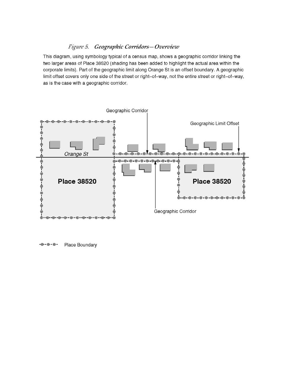
84 5-74
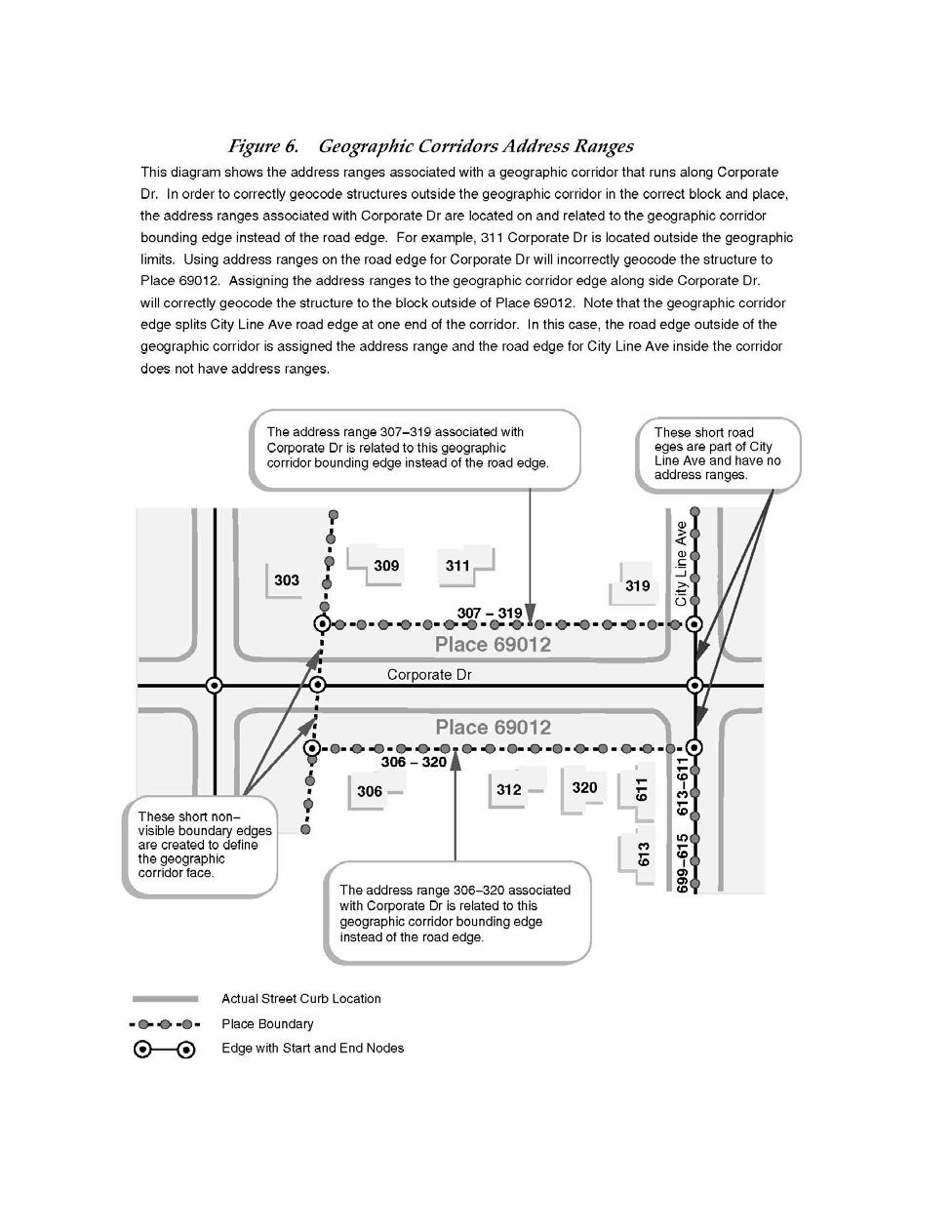
85 5-75
The 2010 Census: Count Question Resolution Program
 The 2010 Census: Count Question Resolution Program Jennifer D. Williams Specialist in American National Government December 7, 2012 CRS Report for Congress Prepared for Members and Committees of Congress
Overview of Census Bureau Geographic Areas and Concepts
 Overview of Census Bureau Geographic Areas and Concepts Drew Stanislaw US Census Bureau WVAGP Annual Meeting Shepherdstown, WV June 13, 2011 1 What is the role of geography in the Census? The Census count
The 2020 Census Geographic Partnership Opportunities. Geography Division U.S. Census Bureau
 The 2020 Census Geographic Partnership Opportunities Geography Division U.S. Census Bureau Legal Legal entities originate from legal actions, treaties, statutes, ordinances, resolutions, court decisions,
Census TIGER US Department of Commerce Economics and Statistics Administration BUREAU OF THE CENSUS
 TIGER/Line Files, 1995 Technical Documentation Census TIGER US Department of Commerce Economics and Statistics Administration BUREAU OF THE CENSUS Acknowledgments The TIGER/Line Files, 1995 Technical Documentation
Version 2.2 April Census Local Update of Census Addresses Operation (LUCA) Frequently Asked Questions
 Frequently Asked Questions") Version 2.2 April 2017 2020 Census Local Update of Census Addresses Operation (LUCA) Frequently Asked Questions [This page intentionally left blank] 2020 Census LUCA Frequently Asked Questions TABLE OF
Version 2.2 April 2017 2020 Census Local Update of Census Addresses Operation (LUCA) Frequently Asked Questions [This page intentionally left blank] 2020 Census LUCA Frequently Asked Questions TABLE OF
The 2020 Census Geographic Partnership Opportunities
 The 2020 Census Geographic Partnership Opportunities Brian Timko Branch Chief Address Data Collection and Products Branch Geography Division U.S. Census Bureau 1 Geographic Partnership Opportunities The
US Census. Thomas Talbot February 5, 2013
 US Census Thomas Talbot February 5, 2013 Outline Census Geography TIGER Files Decennial Census - Complete count American Community Survey Yearly Sample Obtaining Data - American Fact Finder - Census FTP
In-Office Address Canvassing for the 2020 Census: an Overview of Operations and Initial Findings
 In-Office Address Canvassing for the 2020 Census: an Overview of Operations and Initial Findings Michael Commons Address and Spatial Analysis Branch Geography Division U.S. Census Bureau In-Office Address
Using Location-Based Services to Improve Census and Demographic Statistical Data. Deirdre Dalpiaz Bishop May 17, 2012
 Using Location-Based Services to Improve Census and Demographic Statistical Data Deirdre Dalpiaz Bishop May 17, 2012 U.S. Census Bureau Mission To serve as the leading source of quality data about the
Realigning Historical Census Tract and County Boundaries
 Realigning Historical Census Tract and County Boundaries David Van Riper Research Fellow Minnesota Population Center University of Minnesota Twin Cities dvanriper@gmail.com Stanley Dallal ESEA dallal@esea.com
The 2020 Census Geographic Partnership Opportunities
 The 2020 Census Geographic Partnership Opportunities Web Adams Geographer, U.S. Census Bureau New York Regional Office 1 Geographic Partnership Opportunities The 2020 Census Local Update of Census Addresses
GIS Data Sources. Thomas Talbot
 GIS Data Sources Thomas Talbot Chief, Environmental Health Surveillance Section Bureau of Environmental & Occupational Epidemiology New York State Department of Health Outline Sources of Data Census, health,
The Census Bureau s Master Address File (MAF) Census 2000 Address List Basics
 Census 2000 Address List Basics") The Census Bureau s Master Address File (MAF) Census 2000 Address List Basics OVERVIEW The Census Bureau is developing a nationwide address list, often called the Master Address File (MAF) or the Census
The Census Bureau s Master Address File (MAF) Census 2000 Address List Basics OVERVIEW The Census Bureau is developing a nationwide address list, often called the Master Address File (MAF) or the Census
Local Update of Census Addresses Program Promotional Workshop
 Local Update of Census Addresses Program Promotional Workshop Will Your Community Be Ready? US Census Bureau Chicago Regional Office Stanley D. Moore, Regional Director 1 Welcome to the Local Update of
Redistricting San Francisco: An Overview of Criteria, Data & Processes
 Redistricting San Francisco: An Overview of Criteria, Data & Processes Karin Mac Donald Q2 Data & Research, LLC October 5, 2011 1 Criteria in the San Francisco Charter: Districts must conform to all legal
The U.S. Decennial Census A Brief History
 1 The U.S. Decennial Census A Brief History Under the direction of then Secretary of State, Thomas Jefferson, the first U.S. Census began on August 2, 1790, and was to be completed by April 1791 The total
2020 CENSUS LOCAL UPDATE OF CENSUS ADDRESSES OPERATION (LUCA) U.S. Census Bureau Geography Division
 U.S. Census Bureau Geography Division") 2020 CENSUS LOCAL UPDATE OF CENSUS ADDRESSES OPERATION (LUCA) U.S. Census Bureau Geography Division 1 Agenda 2020 Census Local Update of Census Addresses Operation (LUCA) Participation in LUCA Why participate
2020 CENSUS LOCAL UPDATE OF CENSUS ADDRESSES OPERATION (LUCA) U.S. Census Bureau Geography Division 1 Agenda 2020 Census Local Update of Census Addresses Operation (LUCA) Participation in LUCA Why participate
: Geocode File - Census Tract, Block-Group and Block. Codebook
 196815: Geocode File Census Tract, BlockGroup and Block Codebook Number of Variables 15 Friday June 17 8:49 AM 196815: Geocode File Census Tract, BlockGroup and Block RLS1 "RELEASE NUMBER" NUM(1.) Release
2020 CENSUS LOCAL UPDATE OF CENSUS ADDRESSES (LUCA) OPERATION. Frequently Asked Questions (FAQs)
 OPERATION. Frequently Asked Questions (FAQs)") 2020 CENSUS LOCAL UPDATE OF CENSUS ADDRESSES (LUCA) OPERATION Frequently Asked Questions (FAQs) [This page intentionally left blank] Table of Contents Advance Notice... 1 1. What is the 2020 LUCA advance
2020 CENSUS LOCAL UPDATE OF CENSUS ADDRESSES (LUCA) OPERATION Frequently Asked Questions (FAQs) [This page intentionally left blank] Table of Contents Advance Notice... 1 1. What is the 2020 LUCA advance
Handout Packet. QuickFacts o Frequently Asked Questions
 Census Data Immersion Infopeople Webinar August 7, 2012 Handout Packet QuickFacts o Frequently Asked Questions Demographic Program Tips o 2010 Decennial Census o Population Estimates Program (PEP) o American
Census TIGER US Department of Commerce Economics and Statistics Administration BUREAU OF THE CENSUS
 TIGER/Line Files, 1997 Technical Documentation Census TIGER US Department of Commerce Economics and Statistics Administration BUREAU OF THE CENSUS Acknowledgments The 1997 TIGER/Line Files Technical Documentation
Event History Calendar (EHC) Between-Wave Moves File. Codebook
 Between-Wave Moves File. Codebook") 2325 Event History Calendar (EHC) BetweenWave Moves File Codebook Number of Variables 23 Thursday July 2 28 4:5 PM 2325 Event History Calendar (EHC) BetweenWave Moves File EHCV "RELEASE NUMBER" NUM(.)
2325 Event History Calendar (EHC) BetweenWave Moves File Codebook Number of Variables 23 Thursday July 2 28 4:5 PM 2325 Event History Calendar (EHC) BetweenWave Moves File EHCV "RELEASE NUMBER" NUM(.)
Employer Location file. Codebook
 232 Employer Location file Codebook Number of Variables 2 Wednesday July 8 28 :9 PM 232 Employer Location file EMPV "RELEASE NUMBER" NUM(.) Release number Release : 7/28, SAS proc geocode and proc ginside
Participant Statistical Areas Program for the 2010 Census. Vince Osier COPAFS Quarterly Meeting Washington, DC December 8, 2006
 Participant Statistical Areas Program for the 2010 Census Vince Osier COPAFS Quarterly Meeting Washington, DC December 8, 2006 1 Participant Statistical Areas Census Tracts Block Groups Census County Divisions
Case 2:12-cv RJS-DBP Document 184 Filed 08/26/15 Page 1 of 12 UNITED STATES DISTRICT COURT FOR THE DISTRICT OF UTAH CENTRAL DIVISION
 Case 2:12-cv-00039-RJS-DBP Document 184 Filed 08/26/15 Page 1 of 12 UNITED STATES DISTRICT COURT FOR THE DISTRICT OF UTAH CENTRAL DIVISION NAVAJO NATION, a federally recognized Indian tribe, et al., v.
Catalogue no G ISBN Reference Maps and Thematic Maps, Reference Guide. Census year Release date: November 16, 2016
 Catalogue no. 92-143-G ISBN 978-0-660-06710-0 Reference Maps and Thematic Maps, Reference Guide Release date: November 16, 2016 How to obtain more information For information about this product or the
2020 Census Local Update of Census Addresses Operation (LUCA) U.S. Census Bureau Geography Division
 U.S. Census Bureau Geography Division") 2020 Census Local Update of Census Addresses Operation (LUCA) U.S. Census Bureau Geography Division 1 Agenda 2020 Census LUCA Operation Participation in LUCA What is LUCA? Who Can Participate? Why participate?
2020 Census Local Update of Census Addresses Operation (LUCA) U.S. Census Bureau Geography Division 1 Agenda 2020 Census LUCA Operation Participation in LUCA What is LUCA? Who Can Participate? Why participate?
Census Blocks and Block Groups
 Census Blocks and Block Groups Chapter 11 Census blocks, the smallest geographic area for which the Bureau of the Census collects and tabulates decennial census data, are formed by streets, roads, railroads,
NJDEP GPS Data Collection Standards for GIS Data Development
 NJDEP GPS Data Collection Standards for GIS Data Development Bureau of Geographic Information Systems Office of Information Resource Management April 24 th, 2017 Table of Contents 1.0 Introduction... 3
1980 Census 1. 1, 2, 3, 4 indicate different levels of racial/ethnic detail in the tables, and provide different tables.
 1980 Census 1 1. 1980 STF files (STF stands for Summary Tape File from the days of tapes) See the following WWW site for more information: http://www.icpsr.umich.edu/cgi/subject.prl?path=icpsr&query=ia1c
The Road to 2020 Census
 The Road to 2020 Census Wednesday, May 17 th, 2017 9:00 am-12n North Central Texas Council of Governments 616 Six Flags Drive, Arlington, TX Arlington, TX 1 AGENDA OVERVIEW Decennial Census Basics, 2010
The 2020 Census: Preparing for the Road Ahead
 The 2020 Census: Preparing for the Road Ahead Presentation to the National Association of Counties 2017 Annual Conference Columbus, OH July 23, 2017 The Decennial Census Purpose: To conduct a census of
The 2020 Census: A New Design for the 21 st Century Deirdre Dalpiaz Bishop Chief Decennial Census Management Division U.S.
 The 2020 Census: A New Design for the 21 st Century Deirdre Dalpiaz Bishop Chief Decennial Census Management Division U.S. Census Bureau National Conference of State Legislatures Fall Forum December 9,
2020 Census Local Update of Census Addresses Operation (LUCA)
") 2020 Census Local Update of Census Addresses Operation (LUCA) The Decennial Census The purpose is to conduct a census of population and housing and disseminate results to the President, the States, and
2020 Census Local Update of Census Addresses Operation (LUCA) The Decennial Census The purpose is to conduct a census of population and housing and disseminate results to the President, the States, and
American Community Survey: Sample Design Issues and Challenges Steven P. Hefter, Andre L. Williams U.S. Census Bureau Washington, D.C.
 American Community Survey: Sample Design Issues and Challenges Steven P. Hefter, Andre L. Williams U.S. Census Bureau Washington, D.C. 20233 Abstract In 2005, the American Community Survey (ACS) selected
Lecture 8 Geocoding. Dr. Zhang Spring, 2017
 Lecture 8 Geocoding Dr. Zhang Spring, 2017 Model of the course Using and making maps Navigating GIS maps Map design Working with spatial data Geoprocessing Spatial data infrastructure Digitizing File geodatabases
Geographic Terms. Manifold Data Mining Inc. January 2016
 Geographic Terms Manifold Data Mining Inc. January 2016 The following geographic terms are adapted from the standard definition of Census geography from Statistics Canada. Block-face A block-face is one
The 2020 Census A New Design for the 21 st Century
 The 2020 Census A New Design for the 21 st Century The Decennial Census Purpose: To conduct a census of population and housing and disseminate the results to the President, the States, and the American
Catalogue no X. Geography Catalogue. Census year 2011
 Catalogue no. 92-196-X Geography Catalogue Census year 2011 How to obtain more information For information about this product or the wide range of services and data available from Statistics Canada, visit
2020 Census Participant Statistical Areas Program (PSAP) Overview. Joshua Coutts Geography Division U.S. Census Bureau
 Overview. Joshua Coutts Geography Division U.S. Census Bureau") 2020 Census Participant Statistical Areas Program (PSAP) Overview Joshua Coutts Geography Division U.S. Census Bureau 2020 Census PSAP Allows invited participants to review and update selected statistical
2020 Census Participant Statistical Areas Program (PSAP) Overview Joshua Coutts Geography Division U.S. Census Bureau 2020 Census PSAP Allows invited participants to review and update selected statistical
Quick Reference Guide
 U.S. Census Bureau Revised 07-28-13 Quick Reference Guide Demographic Program Comparisons Decennial Census o Topics Covered o Table Prefix Codes / Product Types o Race / Ethnicity Table ID Suffix Codes
Overview of Demographic Data
 Overview of Demographic Data Michael Ratcliffe Geography Division US Census Bureau Mapping Sciences Committee October 20, 2014 Sources of Demographic Data Censuses Full enumeration, or counting, of the
Who s in Your Neighborhood? Using the American FactFinder. Salma Abadin and Carrie Koss Vallejo Data You Can Use
 Who s in Your Neighborhood? Using the American FactFinder Salma Abadin and Carrie Koss Vallejo Data You Can Use www.datayoucanuse.org Learning Objectives Learn what American FactFinder is and is not Become
Dallas Regional Office US Census Bureau
 The Census Bureau: Important Data Products for Every Community Paula Wright, Information Services Specialist Suzee Privett, Information Services Assistant Willie DeBerry, Partnership Specialist Lacey Loftin,
Working with United States Census Data. K. Mitchell, 7/23/2016 (no affiliation with U.S. Census Bureau)
") Working with United States Census Data K. Mitchell, 7/23/2016 (no affiliation with U.S. Census Bureau) Outline Types of Data Available Census Geographies & Timeframes Data Access on Census.gov website
Working with United States Census Data K. Mitchell, 7/23/2016 (no affiliation with U.S. Census Bureau) Outline Types of Data Available Census Geographies & Timeframes Data Access on Census.gov website
2020 Census Local Update of Census Addresses. Operation (LUCA) Promotion
 Promotion") 2020 Census Local Update of Census Addresses Atlanta Regional Office Managing Census Operations in: AL, FL, GA, LA, MS, NC, SC Operation (LUCA) Promotion 2020 Census Overview What is LUCA? Agenda LUCA
2020 Census Local Update of Census Addresses Atlanta Regional Office Managing Census Operations in: AL, FL, GA, LA, MS, NC, SC Operation (LUCA) Promotion 2020 Census Overview What is LUCA? Agenda LUCA
Geog 3340: Census Basics
 Geog 3340: Census Basics About the US Census Bureau Mandated by the U. S. Constitution to count the population Used: to apportion seats in the U.S. House of Representatives to define legislature districts,
2020 Census Geographic Partnership Programs. Update. Atlanta Regional Office Managing Census Operations in: AL, FL, GA, LA, MS, NC, SC
 2020 Census Geographic Partnership Programs Atlanta Regional Office Managing Census Operations in: AL, FL, GA, LA, MS, NC, SC Update Alabama State Data Center Conference Agenda 2020 Census Overview 2020
Map and Drawing Standards for the South Pacific Division Regulatory Program
 Map and Drawing Standards for the South Pacific Division Regulatory Program Hollis Jencks Project Manager, Nevada/Utah Section Sacramento District Regulatory Program Workshop 31 May 2018 US Army Corps
Historical Business Academic Layout
 Historical Business Academic Layout Order Output Field Name Output Field Definition/Description 1 Company NAME OF BUSINESS - WILL HAVE BLANKS 2 Address Line 1 HISTORICAL ADDRESS 3 City HISTORICAL ADDRESS
Reengineering the 2020 Census
 Reengineering the 2020 Census John Thompson Director U.S. Census Bureau Lisa M. Blumerman Associate Director Decennial Census Programs U.S. Census Bureau Presentation to the Committee on National Statistics
Road to the 2020 Census October 13, :15 p.m. 5:15 p.m. WEBINAR Presentation for: South Dakota - State Data Center s 5 th Annual Demography
 Road to the 2020 Census October 13, 2017 4:15 p.m. 5:15 p.m. WEBINAR Presentation for: South Dakota - State Data Center s 5 th Annual Demography Conference Presenter: Blanca Ramirez-Salazar, Partnership
National Association of Regional Councils San Antonio, Texas October 23, 2017
 Preparing for the 2020 Census Role of State and Local Governments National Association of Regional Councils San Antonio, Texas October 23, 2017 @TexasDemography The best possible count in 2020 matters
Census 2010 Participation Rates, Results for Alaska, and Plans for the 2020 Census
 Census 2010 Participation Rates, Results for Alaska, and Plans for the 2020 Census Evan Moffett, Assistant Division Chief Geographic Operations Decennial Census Management Division U.S. Census Bureau 2016
1 NOTE: This paper reports the results of research and analysis
 Race and Hispanic Origin Data: A Comparison of Results From the Census 2000 Supplementary Survey and Census 2000 Claudette E. Bennett and Deborah H. Griffin, U. S. Census Bureau Claudette E. Bennett, U.S.
Experiences with the Use of Addressed Based Sampling in In-Person National Household Surveys
 Experiences with the Use of Addressed Based Sampling in In-Person National Household Surveys Jennifer Kali, Richard Sigman, Weijia Ren, Michael Jones Westat, 1600 Research Blvd, Rockville, MD 20850 Abstract
2010 Census Data. Get Ready for Changes in Your 2014 AAPs. Ellen Shong & Associates, LLC 9/13/ Past EEO Tabulations
 2010 Census Data Get Ready for Changes in Your 2014 AAPs Ellen Shong & Associates, LLC 9/13/2013 1 Past EEO Tabulations ORC tabulation based on 1970 Census occupational data. Funded by private organization
Environmental Justice Tool Guide
 Environmental Justice Tool Guide This document is intended to accompany the Environmental Justice section of MnDOT s Highway Project Development Process. This document provides additional guidance to steps
Postal Codes OM by Federal Ridings File (PCFRF) 2013 Representation Order, Reference Guide
 2013 Representation Order, Reference Guide") Catalogue no. 92-178-G ISSN 2369-9809 Postal Codes OM by Federal Ridings File (PCFRF) 2013 Representation Order, Reference Guide June 2017 Release date: December 13, 2017 How to obtain more information
Catalogue no. 92-178-G ISSN 2369-9809 Postal Codes OM by Federal Ridings File (PCFRF) 2013 Representation Order, Reference Guide June 2017 Release date: December 13, 2017 How to obtain more information
2020 Census Geographic Partnership Programs. Heidi Crawford Data Dissemination Specialist U.S. Census 1 Bureau
 2017 Oregon Census Data Users Workshop September 20 &21, 2017 2020 Census Geographic Partnership Programs Heidi Crawford Data Dissemination Specialist U.S. Census 1 Bureau Geographic Partnership Opportunities
9 LAND SURVEYING. 9.1 General. 9.2 Administrative Requirements Standards Meetings Survey Data Provided to the Design-Builder
 9 LAND SURVEYING 9.1 General The Design-Builder shall conduct all Work necessary to meet the requirements associated with land surveying, including Project and supplemental horizontal and vertical control
Become a 2010 Census Partner
 State and Local Governments Become a 2010 Census Partner In 2010, the U.S. Census Bureau will issue a call to action for every resident of our nation: Be Counted. The 2010 Census is important. It determines
Copyright The McGraw-Hill Companies, Inc. Permission required for reproduction or display.
 Chapter 16. GEOCODING AND DYNAMIC SEGMENTATION 16.1 Geocoding 16.1.1 Geocoding Reference Database 16.1.2 The Address Matching Process 16.1.3 Address Matching Options Box 16.1 Scoring System for Geocoding
Census Data Boot Camp
 Census Data Boot Camp WVAGP Annual Meeting June 14, 2011 Laura Waggoner Katy Rossiter Drew Stanislaw US. Census Bureau Census Data Boot Camp Outline 2010 Census Overview Geographic Products and Mapping
2020 Census Local Update of Census Addresses. Operation (LUCA) Promotion
 Promotion") 2020 Census Local Update of Census Addresses Atlanta Regional Office Managing Census Operations in: AL, FL, GA, LA, MS, NC, SC Operation (LUCA) Promotion 2020 Census Overview What is LUCA? Agenda LUCA
2020 Census Local Update of Census Addresses Atlanta Regional Office Managing Census Operations in: AL, FL, GA, LA, MS, NC, SC Operation (LUCA) Promotion 2020 Census Overview What is LUCA? Agenda LUCA
FEDERAL INFORMATION PROCESSING STANDARDS (FIPS) 55, [1984] (ICPSR 8346) Principal Investigator
![FEDERAL INFORMATION PROCESSING STANDARDS (FIPS) 55, [1984] (ICPSR 8346) Principal Investigator](/thumbs/74/71162432.jpg "FEDERAL INFORMATION PROCESSING STANDARDS (FIPS) 55, [1984] (ICPSR 8346) Principal Investigator") 1 FEDERAL INFORMATION PROCESSING STANDARDS (FIPS) 55, [1984] (ICPSR 8346) Principal Investigator United States Department of Commerce Bureau of Census First ICPSR Release 1985 Inter-university Consortium
1 FEDERAL INFORMATION PROCESSING STANDARDS (FIPS) 55, [1984] (ICPSR 8346) Principal Investigator United States Department of Commerce Bureau of Census First ICPSR Release 1985 Inter-university Consortium
Central Cancer Registry Geocoding Needs
 Central Cancer Registry Geocoding Needs John P. Wilson, Daniel W. Goldberg, and Jennifer N. Swift Technical Report No. 13 Central Cancer Registry Geocoding Needs 1 Table of Contents Executive Summary...3
My Tribal Area: Census Data Overview & Access. Eric Coyle Data Dissemination Specialist U.S. Census Bureau
 My Tribal Area: Census Data Overview & Access Eric Coyle Data Dissemination Specialist U.S. Census Bureau AGENDA Overview of Census Bureau Programs and Datasets available Census Geographies Ways to Access
American Community Survey Overview
 American Community Survey Overview ACS Data Users Conference May 11, 2015 Gretchen Gooding American Community Survey Office 1 Outline American Community Survey (ACS) basics Resources for learning more
Postal Codes OM by Federal Ridings File (PCFRF) 2013 Representation Order, Reference Guide
 2013 Representation Order, Reference Guide") Catalogue no. 92-178-G Postal Codes OM by Federal Ridings File (PCFRF) 2013 Representation Order, Reference Guide August 2015 postal codes OM How to obtain more information For information about this product
Catalogue no. 92-178-G Postal Codes OM by Federal Ridings File (PCFRF) 2013 Representation Order, Reference Guide August 2015 postal codes OM How to obtain more information For information about this product
The coordinate system and vertical datum shall be noted in the drawing in the metadata.
 Purpose This document is provided for informational purposes and to assure data compatibility and compliance for as-built drawings or vector data formats specifically for the 354th Civil Engineer Squadron
Reference Maps and Thematic Maps, Reference Guide
 Catalogue no. 92-143-G Reference Maps and Thematic Maps, Reference Guide Census year 2011 How to obtain more information For information about this product or the wide range of services and data available
Census Data for Grant Writing Workshop Cowlitz-Wahkiakum Council of Governments. Heidi Crawford Data Dissemination Specialist U.S.
 Census Data for Grant Writing Workshop Cowlitz-Wahkiakum Council of Governments Heidi Crawford Data Dissemination Specialist U.S. Census Bureau Agenda Welcome and Introductions Overview of Census Data
ESP 171 Urban and Regional Planning. Demographic Report. Due Tuesday, 5/10 at noon
 ESP 171 Urban and Regional Planning Demographic Report Due Tuesday, 5/10 at noon Purpose The starting point for planning is an assessment of current conditions the answer to the question where are we now.
Welcome to: A Tour of Data Sources from the U.S. Census Bureau. Monday, October 19, :00 am 12:00 noon CT
 Welcome to: A Tour of Data Sources from the U.S. Census Bureau Monday, October 19, 2015 11:00 am 12:00 noon CT 1 Illinois Early Childhood Asset Map (IECAM) http://iecam.illinois.edu University of Illinois
Site Plan/Building Permit Review
 Part 6 Site Plan/Building Permit Review 1.6.01 When Site Plan Review Applies 1.6.02 Optional Pre- Application Site Plan/Building Permit Review (hereafter referred to as Site Plan Review) shall be required
Census Geography Items in the Homer Babbidge Collection
 University of Connecticut DigitalCommons@UConn UCCGIA University of Connecticut Center for Geographic Information and Analysis and MAGIC February 2008 Census Geography Items in the Homer Babbidge Collection
2010 Census Tribal Statistical Areas Program. Guidelines for Updating State Reservations
 2010 Census Tribal Statistical Areas Program Guidelines for Updating State Reservations Version 1 January 2009 1. Introduction... 3 2. Background on the State Reservation Program... 4 2.1 Eligibility...
United Nations Statistics Division Programme in Support of the 2020 Round of Population and Housing Censuses
 United Nations Statistics Division Programme in Support of the 2020 Round of Population and Housing Censuses Srdjan Mrkić United Nations Statistics Division Definitions A population census is the total
February 21, U.S. Census Bureau Report: Tabulating Prisoners at Their Permanent Home of Record Address
 February 21, 2006 U.S. Census Bureau Report: Tabulating Prisoners at Their Permanent Home of Record Address This page intentionally left blank. Contents Executive Summary... i 1. Introduction...1 2. Summary
2020 Census. Bob Colosi Decennial Statistical Studies Division February, 2016
 2020 Census Bob Colosi Decennial Statistical Studies Division February, 2016 Decennial Census Overview (1 of 2) Purpose: To conduct a census of population and housing and disseminate the results to the
QualityStage AVI+Geo+US Census+UK PAF v10.5 Output as of 2015 Q3 AVI Release
 Field Name Organization Department Function Building Subbuilding HouseNumber Street DependentStreet POBox Dependent DoubleDependent PostCode PostCodePrimary PostCodeSecondary Super Sub Country ISO3166_2
Census Data Determines Who Gets $300 Billion Annually Are You Getting Your Share?
 Census Data Determines Who Gets $300 Billion Annually Are You Getting Your Share? Hartford Foundation for Public Giving November 13, 2009 Jim Palma, Partnership Specialist Hartford Local Census Office
2020 Census Participant Statistical Areas Program (PSAP)
") 2020 Census Participant Statistical Areas Program (PSAP) 2020 Census Participant Statistical Areas Program (PSAP) You just finished the LUCA (Local Update of Census Addresses) Program, and now it s time
2020 Census Participant Statistical Areas Program (PSAP) 2020 Census Participant Statistical Areas Program (PSAP) You just finished the LUCA (Local Update of Census Addresses) Program, and now it s time
COUNTRY REPORT: TURKEY
 COUNTRY REPORT: TURKEY (a) Why Economic Census? - Under what circumstances the Economic Census is conducted in your country. Why the economic census is necessary? - What are the goals, scope and coverage
Notes on the 2014 ACS 5-Year Estimates
 Notes on the 2014 ACS 5-Year Estimates Eric Guthrie, Michigan s State Demographer December 3, 2015 The U.S. Census Bureau has released the 2014 American Community Survey (ACS) 5-year estimates. The 5-year
GPS Accuracy in Urban Environments Using Post-Processed CORS Data
 GPS Accuracy in Urban Environments Using Post-Processed CORS Data Knute A. Berstis, Gerald L. Mader NOAA, NOS, National Geodetic Survey Silver Spring, MD Aaron Jensen US Census Bureau Washington, DC Presentation
SPECIAL PUBLIC NOTICE
 SPECIAL PUBLIC NOTICE Draft Map and Drawing Standards for the South Pacific Division Regulatory Program August 6, 2012 Corps contacts: Sacramento District: Michael Finan (916) 557-5324 (Michael.C.Finan@usace.army.mil)
2020 Census: How Communities Can Prepare
 2020 Census: How Communities Can Prepare Wednesday, November 16, 2017 Annual NM SDC Affiliates Meeting and Workshop Zimmerman Library, University of NM, Albuquerque, NM Presenters: Pauline Núñez, Partnership
National Longitudinal Study of Adolescent Health. Public Use Contextual Database. Waves I and II. John O.G. Billy Audra T. Wenzlow William R.
 National Longitudinal Study of Adolescent Health Public Use Contextual Database Waves I and II John O.G. Billy Audra T. Wenzlow William R. Grady Carolina Population Center University of North Carolina
Making Sense of Census Data Robert Matthews, University of Alabama at Birmingham, Birmingham, Alabama
 Paper MPSF 074 Making Sense of Census Data Robert Matthews, University of Alabama at Birmingham, Birmingham, Alabama ABSTRACT The United States Census Bureau publishes a vast amount of data on many different
Geocoding Techniques and Options for US and International Locations
 Federal GIS Conference 2014 February 10 11, 2014 Washington DC Geocoding Techniques and Options for US and International Locations Tosia Shall, Esri Doug Geverdt, Census Chuck Whittington, Census Types
Memorandum City of Lawrence Planning and Development Services
 Memorandum City of Lawrence Planning and Development Services TO: FROM: CC: David L. Corliss, City Manager Amy Miller, Long-Range Planner David Guntert, GIS Planner Scott McCullough, Planning & Development
Census Pro Documentation
 Census Pro Documentation Introduction: Census Pro is our name for both our Census Demographics data, and our Data Extractor, which allows our clients to select just the data they need, in the format they
The American Community Survey. An Esri White Paper August 2017
 An Esri White Paper August 2017 Copyright 2017 Esri All rights reserved. Printed in the United States of America. The information contained in this document is the exclusive property of Esri. This work
Lecture 8: GIS Data Error & GPS Technology
 Lecture 8: GIS Data Error & GPS Technology A. Introduction We have spent the beginning of this class discussing some basic information regarding GIS technology. Now that you have a grasp of the basic terminology
ISO INTERNATIONAL STANDARD. Geographic information Positioning services. Information géographique Services de positionnement
 INTERNATIONAL STANDARD ISO 19116 First edition 2004-07-01 Geographic information Positioning services Information géographique Services de positionnement Reference number ISO 19116:2004(E) ISO 2004 PDF
Public Use Microdata Sample Files Data Note 1
 Data Note 1 TECHNICAL NOTE ON SAME-SEX UNMARRIED PARTNER DATA FROM THE 1990 AND 2000 CENSUSES The release of data from the 2000 census has brought with it a number of analyses documenting change that has
U.S. Synthetic Population 2010 Version 1.0
 RTI Project Number 0212177.005.002 U.S. Synthetic Population 2010 Version 1.0 Quick Start Guide May, 2014 Prepared by RTI International 3040 Cornwallis Road Research Triangle Park, NC 27709 This work was
INTEGRATED COVERAGE MEASUREMENT SAMPLE DESIGN FOR CENSUS 2000 DRESS REHEARSAL
 INTEGRATED COVERAGE MEASUREMENT SAMPLE DESIGN FOR CENSUS 2000 DRESS REHEARSAL David McGrath, Robert Sands, U.S. Bureau of the Census David McGrath, Room 2121, Bldg 2, Bureau of the Census, Washington,