X-WALD. Avionic X-band Weather signal modeling and processing validation through real Data acquisition and analysis
|
|
|
- Cora Annabella Watson
- 6 years ago
- Views:
Transcription
1 X-WALD Avionic X-band Weather signal modeling and processing validation through real Data acquisition and analysis State of the art Background All civil airplanes and military transport aircrafts are equipped with avionic weather radars (AWR). Current AWRs allow different functionalities concerning the detection of dangerous weather phenomena. Typical and possible methods and systems so far developed, both for ground-based and for airborne applications, to detect dangerous weather zones and to be implemented in future weather radar systems are: (1) conventional radar, that is, non-coherent radar, which is able to measure radar reflectivity only, disregarding signal polarization features; (2) coherent (Doppler) radar, that can measure Doppler spectrum parameters; (3) polarimetric radar, which takes into account signal polarization to improve system performance characteristics. The maximum amount of information can be obtained by the Dopplerpolarimetric radar, that combines both Doppler and polarimetric diversity to improve detection performances. Single polarization radar permits to detect only the intensity of the meteorological phenomenon, which is anyway related, if such intensity is remarkable, to harsh and dangerous conditions, like hailstorms and strong turbulence. Polarimetric radars can provide more refined information about the type of precipitation once the model of specific hydrometeor (rain, snow or hail) is known. Polarimetry is commonly exploited in ground-based meteorological radar for weather forecasting. Existing airborne polarimetric radars are mainly used for research purposes, as in the case of the NASA Airborne Rain Mapping Radar (ARMAR), to remotely sense the weather phenomena, without supporting flight hazard assessment. In the framework of the CLEANSKY program and specifically in the Clean Sky Systems for Green Operations (SGO) Integrated Technological Demonstrator (ITD), the use of a polarimetric avionic radar has been proposed in the Management of Trajectory and Mission (MTM) study to get more accurate information about unforecasted weather phenomena. The goal is to optimize the skipping trajectories so as to minimize the noise pollution and emissions during each flight phase of the airplane. To this purpose, two projects (CLEOPATRA and KLEAN) have been sponsored by the JU-SGO aimed at developing an avionic polarimetric radar signal simulator (CleoSim), implementing and testing polarimetric signal processing (AWR processing (AWRP), AWR post-processing (AWRPP)) and trajectory optimization algorithms on an EFB (Electronic Flight Bag). An EFB is an electronic display system designed to replace the traditional pilot flight bag and to reduce or eliminate the need for paper and other referencematerial in the cockpit. For the JU- SGO MTM activities, the use of a polarimetric radar simulator has been considered due to the unavailability of commercial and/or experimental avionic polarimetric radars among the JU-SGO members and by the unavailability of commercial systems. The advantage of the simulator is that any kind of weather scenario can be generated, which is of great importance to extensively test signal processing and trajectory optimization algorithms. Obviously, algorithm performance analysis results and implementation of the algorithm on an EFB are strictly dependent on the reliability of the polarimetric radar simulator. In this context, the availability of real data in a well-monitored scenario would be of great importance to test the quality of the simulator as well as the capability of the algorithms. Objectives the MAIN objectives of the project were to plan and run ad hoc measurements finalized to optimize, test and validate: 1 the CleoSim radar signal simulator, 2 the radar signal processing and weather classification algorithms implemented on an EFB in the KLEAN project, 3 the EFB GUI interfaces for the advanced display of weather classifications and decision-making advices developed in KLEAN To achieve this goal, the following objectives have been pursued: - X-BAND polarimetric radar overview, selection and acquisition. The radar has been mounted on the nose of airborne platforms for gathering data in presence of weather events in compliance with the JU-SGO goals, - planning the ad hoc measurement campaign in well-monitored selected scenarios - experiments conduction and data acquisition, - optimization and validation of the avionic polarimetric radar signal simulator (CleoSim), - optimization and validation of the EFB weather radar signal processing and trajectory optimization algorithms (KLEAN project) - Refinement of the EFB GUI in accordance with the needs resulting from the experimental data analysis - EFB SW refinement and implementation to a level TRL5 (Technology Readiness Level 5)
2 Description of work The X-WALD project has been implemented through the following eight Work Packages, those numbered from 3 to 7 concerning research and development activities: WP1 - Project management: primarily aimed at providing a structured system for the full administrative and technical management of the project, addressing all methods of risk management, quality assurance and confidentiality including Intellectual Property Rights (IPR) handling. WP2 Analysis of the signal models, processing algorithms and EFB implementation: this WP is aimed at finding out what are the critical aspects and limitations in reliability of the simulator and algorithms, as possibly caused by the inaccuracy of models and absence of real data. WP3 X-band avionic polarimetric radar selection and acquisition. Tthe goals of this WP were: an overview of the existing X-band airborne polarimetric radar, the selection of the radar, the radar updating in order to fulfil the expected performance and the definition of the modalities of the radar acquisition. WP4 Measurement campaign planning. This WP included the following activities: the definition of the measurement scenario, the selection of the areas where the trials could be run, the selection of the airborne platforms, the definition and selection of auxiliary sensors. WP5 Experiment and data acquisition. This WP aimed at carrying out all activities related to the preparation and execution of the experiments. The radar was installed in the nose of the airborne platforms in order to reproduce the avionic radar operating conditions. WP6 Meteorological signal models assessment and optimization. Tthis WP concerned the validation and optimization of the polarimetric signal simulator making use of real data gathered during the experiments. WP7 EFB processing algorithms assessment and optimization. This WP aimed at the testing and the optimization of the SW tools inside the EFB: the Advanced Weather Radar processing (AWRP), the AWR Post-Processing (AWRPP) for feature extraction, identification and classification of weather, the Q-AI trajectory optimization algorithm and the advanced GUI interfaces. WP8 Exploitation and dissemination. This WP outlined how to develop the exploitation and the dissemination of the XWALD results in the SGO CLEANSKY program, in other European projects (FP7, H2020. etc), manufacturing industries and in the technical and scientific community, following Clean Sky JU directives. Results a) Timeline & main milestones Set t0=1 January 2014 Milestone no., Milestone Name, delivery date MS1, Kick off meeting, t0 MS2, Release of the X-WALD SoW, t0+6 MS3, Avionic radar selection and acquisition, t0+13 MS4, Measurement campaign planning, t0+9 MS5, Experiments, t0+25 MS6, Validation and optimization of signal models, t0+28 MS7 Validation of EFB algorithms, t0+28 MS8 KLEN SW tool refinement, t0+28 MS9 Workshop and exhibitions t0+31 b) Environmental benefits The use of on board polarimetric weather radar increases the weather event awareness. Therefore it could be possible to reduce the flight detours for escaping bad weather event in the cases the polarimetric post processor weather classification algorithm classifies them as non-dangerous. The trajectory computed by the trajectory optimization tool using the polarimetric weather radar classification allows the reduction of the emissions of CO2 and NOx when compared to those of trajectories computed with non polarimetric radar. c) Maturity of works performed The X-WALD project allowed to assembly a prototype of polarimetric radar for running the first European polarimetric weather radar measurements to be used for the validation and the optimization of: - the radar signal software simulator, - the radar signal processing chain and the weather classification algorithms, - the EFB KLEAN TOOL: polarimetric weather radar signal processing and trajectory optimization algorithms. The radar signal software simulator is ready to be used for simulating the polarimetric outputs of airborne polarimetric weather radars in any weather condition. The polarimetric weather radar signal processing and the trajectory optimization algorithms reached the TRL5. The polarimetric radar prototpye is ready for a wide measurement campaign whose objective is to collect a significant all-weather statistical dataset for assessing the operative performance of of the KLEAN SW TOOL.

3 Picture, Illustration Investigated avionic X-band weather radar sensors available on the market. All of them are characterized by single polarization feature, and, therefore, none of them was suitable for XWALD


4 Upgrades implemented by MetaSensing in its radar sensor at X band for adapting its detection performance to the one expected for the XWALD project.


5 Radar installation and certification on the DA-42 at Diamond facilities, in Austria. From top left, clockwise: CAD study of potential location for different radar subsystems; actual implementation in the front nose; avionics instrumentation monitored during RFI tests for certification; mechanical check of installation for certification. Radar installation onboard the Piaggio P-166.
 during the first XWALD")


6 Nose pod-equipped DA42 at the airport of Teuge (NL) during the first XWALD measurement campaign. Nose pod-equipped P-166 at the airport of Terni (IT) during the second XWALD measurement campaign. Acquisition flight of March 11, 2016, in Italy: on the left, meteorological situation showing lightning events; on the right, performed trajectory.

 and 16")

 and")
7 Acquisition flight trajectories of 15 (top) and 16 (bottom) March 2016 Scenarios observed during the 15 (left) and 16 (right) March 2016 flights
 and 16 (bottom) March 2016.")
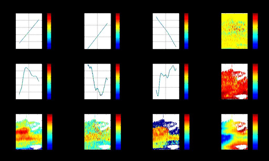
8 Example of Range-Doppler spectrograms processed from data acquired during the flights on 15 (top) and 16 (bottom) March In both cases, the four polarimetric channels are shown.
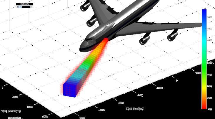
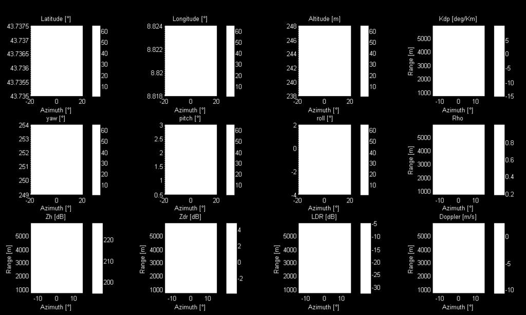
9 Radar illuminated region Example of measured radar observables.

10 Airborne measurements (on the left) and airborne simulations (on the right)

, results for")
.")
11 Hydrometeor classification algorithm Reflectivity map from ground weather radar (top left) and simulated (top right), Hydrometeor classification results for real (bottom left) and simulated dataset (bottom right).
 presentation of routes and waypoints (planned route and")

12 The EFB GUI main screen soon after the no flight zone event (left), and after (right) presentation of routes and waypoints (planned route and its waypoints are all in green, the Q- AI proposed route and its waypoints are in magenta. The WP button switches on/off the visibility of labels.
. Circles are at 40 and nm.")

 using geographical")

13 EFB screen - Comparison of zoom level 1 (left) and level 2 (center). Circles are at 40 and nm. Red arrows (left) indicates the 1 Hz red lines blinking corresponding to risk area EFB screen - Adaptive presentation of risk zone (red contour) and safe zone (yellow contour) using geographical (left) and aircraft based (right) reference system. Hydrometeor classification colours: red-hail, brown-snow, green-rain.
14 Acronym : XWALD Project Summary Name of proposal: Technical domain: Involved ITD Avionic X-band Weather signal modeling and processing validation through real Data acquisition and analysis ITD-SGO Grant Agreement: Instrument: Clean Sky JU Total Cost: Clean Sky contribution: Call: JTI-CS SGO Starting date: Ending date: Duration: 28 m Coordinator contact details: Fabrizio Berizzi CONSORZIO NAZIONALE INTERUNIVERSITARIO PER LE TELECOMUNICAZIONI Tel: Fax: f.berizzi@iet.unipi.it Project website address: Project Officer: Antonio Vecchio Antonio.Vecchio@cleansky.eu Participating members 1) CONSORZIO NAZIONALE INTERUNIVERSITARIO PER LE TELECOMUNICAZIONI 2) INGEGNERIA DEI SISTEMI 3) METASENSING 4) POLITECNICO DI MILANO
PROJECT FINAL REPORT
 PROJECT FINAL REPORT Grant Agreement number: 619236 Project acronym: X-WALD Project title: Avionic X-band Weather signal modeling and processing validation through real Data acquisition and analysis Funding
CASE STUDY BRIDGE DYNAMIC MONITORING
 Introduction BRIDGE DYNAMIC MONITORING Monitoring of structure movements and vibrations (bridges, buildings, monuments, towers etc.) is an increasingly important task for today s construction engineers.
Systems for Green Operations ITD
 Annual Implementation Plan 2009 ITD Systems for Green Operations Annex 1E Proprietary information: SGO ITD 1/15 RECORD OF REVISIONS Revisions Date Description Issue 0 29/09/2008 Creation of the document
Radar/Lidar Sensors SESAR XP1 Trials at CDG airport WakeNet-USA October 2012 Boeing, Seattle, USA
 www.thalesgroup.com Radar/Lidar Sensors SESAR XP1 Trials at CDG airport WakeNet-USA 17-18 October 2012 Boeing, Seattle, USA 2 / Agenda SESAR P12.2.2 overview Organization Development plan Planning and
Civil Radar Systems.
 Civil Radar Systems www.aselsan.com.tr Civil Radar Systems With extensive radar heritage exceeding 20 years, ASELSAN is a new generation manufacturer of indigenous, state-of-theart radar systems. ASELSAN
The EDA SUM Project. Surveillance in an Urban environment using Mobile sensors. 2012, September 13 th - FMV SENSORS SYMPOSIUM 2012
 Surveillance in an Urban environment using Mobile sensors 2012, September 13 th - FMV SENSORS SYMPOSIUM 2012 TABLE OF CONTENTS European Defence Agency Supported Project 1. SUM Project Description. 2. Subsystems
Detection and Identification of Remotely Piloted Aircraft Systems Using Weather Radar
 Microwave Remote Sensing Laboratory Detection and Identification of Remotely Piloted Aircraft Systems Using Weather Radar Krzysztof Orzel1 Siddhartan Govindasamy2, Andrew Bennett2 David Pepyne1 and Stephen
PROJECT FINAL REPORT Publishable Summary
 PROJECT FINAL REPORT Publishable Summary Grant Agreement number: 205768 Project acronym: AGAPE Project title: ACARE Goals Progress Evaluation Funding Scheme: Support Action Period covered: from 1/07/2008
ARCHIVED REPORT. For data and forecasts on current programs please visit or call
 Radar Forecast ARCHIVED REPORT For data and forecasts on current programs please visit www.forecastinternational.com or call +1 203.426.0800 ASR-23SS - Archived 08/2003 Outlook Production complete Procured
SESAR Wake vortex measurements by radar. First results of the campaign
 SESAR Wake vortex measurements by radar. First results of the 2014-2015 campaign Ph. Juge Previous campaigns in SESAR P12.02.02 XP0 : 2011 2 months Main Objective Define the adequate set of needed sensors
FP7 AAT Level 0. FP7 AAT Level 0. Roberto Bojeri. Workshop ACARE Italia. Torino, 17 Maggio 2012
 FP7 AAT Level 0 Roberto Bojeri Workshop ACARE Italia Torino, 17 Maggio 2012 1 Content: questions answered by this presentation Perché? 1. Scope of the Level 0 Cosa? 2. The new "instrument" Level 0 Dove?
Next Generation Operational Met Office Weather Radars and Products
 Next Generation Operational Met Office Weather Radars and Products Pierre TABARY Jacques PARENT-DU-CHATELET Observing Systems Dept. Météo France Toulouse, France pierre.tabary@meteo.fr WakeNet Workshop,
Politecnico di Torino. Porto Institutional Repository
 Politecnico di Torino Porto Institutional Repository [Proceeding] Developing a low cost multipurpose X-band FMICW radar Original Citation: Lucianaz, C.; Bertoldo, S.; Petrini, P.; Allegretti, M. (2016).
ARCHIVED REPORT. For data and forecasts on current programs please visit or call
 Radar Forecast ARCHIVED REPORT For data and forecasts on current programs please visit www.forecastinternational.com or call +1 203.426.0800 Outlook Barring further developments, this report will be archived
Microwave Remote Sensing
 Provide copy on a CD of the UCAR multi-media tutorial to all in class. Assign Ch-7 and Ch-9 (for two weeks) as reading material for this class. HW#4 (Due in two weeks) Problems 1,2,3 and 4 (Chapter 7)
Air Traffic Soft. Management. Ultimate System. Call Identifier : FP TREN-3 Thematic Priority 1.4 Aeronautics and Space
 En Route Air Traffic Soft Management Ultimate System Call Identifier : FP6-2004-TREN-3 Thematic Priority 1.4 Aeronautics and Space EUROCONTROL Experimental Centre EUROCONTROL Innovative Research Workshop
A n I n t e g r a t e d S y s t e m f o r w a v e m o n i t o r i n g a n d s m a l l a n d s l o w t a r g e t s d e t e c t i o n
 A n I n t e g r a t e d S y s t e m f o r w a v e m o n i t o r i n g a n d s m a l l a n d s l o w t a r g e t s d e t e c t i o n Remocean S.p.A. P.IVA e C.F.: 06730281216 - Numero REA: NA - 835413 Registered
DETECTION OF SMALL AIRCRAFT WITH DOPPLER WEATHER RADAR
 DETECTION OF SMALL AIRCRAFT WITH DOPPLER WEATHER RADAR Svetlana Bachmann 1, 2, Victor DeBrunner 3, Dusan Zrnic 2 1 Cooperative Institute for Mesoscale Meteorological Studies, The University of Oklahoma
The Polarimetric Dynamical Estimator HRP Improving Success in the Detection Process
 Angelo M. Ricci and R. Trinci Radar Cross Section Dpt. Istituto per le Telecomunicazioni l Elettronica Giancarlo Vallauri Italian Navy - Mariteleradar Viale Italia, 72 57126 Livorno Italy tel: +39 0586
European Commission Workshop «SATELLITE IMAGERY AND ILLEGAL OIL SPILLS IN EUROPE AND IN THE MEDITERRANEAN» Round table 1 : «DETECTION TECHNIQUES»
 European Commission Workshop «SATELLITE IMAGERY AND ILLEGAL OIL SPILLS IN EUROPE AND IN THE MEDITERRANEAN» Round table 1 : «DETECTION TECHNIQUES» Round table 2 : «MUTUAL INFORMATION AND PROSECUTION PROCEDURES»
H2020 Aviation - new "Level 0"
 H2020 Aviation - new "Level 0" Roberto Bojeri Partnering Event ACARE Italia Roma, 11 Luglio 2013 1 Content 1. Scope of the original Level 0 in FP7 2. The new Funding Scheme in FP7 3. The Level 0 in the
Real-Time Thermo Graphic Analysis of Volcanic Eruptions
 Real-Time Thermo Graphic Analysis of Volcanic Eruptions Bruno Andò 1, Emilio Pecora 2, Nicola Pitrone 1 1 Dipartimento di Ingegneria Elettrica, Elettronica e dei Sistemi, Università di Catania Viale A.
3. give specific seminars on topics related to assigned drill problems
 HIGH RESOLUTION AND IMAGING RADAR 1. Prerequisites Basic knowledge of radar principles. Good background in Mathematics and Physics. Basic knowledge of MATLAB programming. 2. Course format and dates The
Helicopter Aerial Laser Ranging
 Helicopter Aerial Laser Ranging Håkan Sterner TopEye AB P.O.Box 1017, SE-551 11 Jönköping, Sweden 1 Introduction Measuring distances with light has been used for terrestrial surveys since the fifties.
Low frequency SAR data-dome collection with the Bright Sapphire II instrument
 Low frequency SAR data-dome collection with the Bright Sapphire II instrument Specialists meeting on Remote Intelligence of Building Interiors Sam DOODY May 2017 Low Frequency Airborne SAR Justification
Track side measuring system: prototype implementation Malching
 Track side measuring system: prototype implementation Malching 2007 - EUROPAC project partners 1 Introduction to EUROPAC EUROPAC is gathering major European railway stakeholders around a research project
WORKSHOP AND GROUP SHOOT AIRBORNE HYPERSPECTRAL REMOTE SENSING. April 21 to April 30, 2009 Airfield Wiener Neustadt, AUSTRIA
 WORKSHOP AND GROUP SHOOT AIRBORNE HYPERSPECTRAL REMOTE SENSING April 21 to April 30, 2009 Airfield Wiener Neustadt, AUSTRIA INVITATION TO PARTICIPATE DIAMOND Airbone Sensing GmbH, Wiener Neustadt, AUSTRIA
SG3 Software, Databanks and Testing Procedures
 ITU WORKSHOP Overview of activities of ITU-R Study Group 3 on radiowave propagation: (The Hague, 10 April 2014) SG3 Software, Databanks and Testing Procedures Antonio Martellucci Carlo Riva International
High Resolution W-Band Radar Detection and Characterization of Aircraft Wake Vortices in Precipitation. Thomas A. Seliga and James B.
 High Resolution W-Band Radar Detection and Characterization of Aircraft Wake Vortices in Precipitation Thomas A. Seliga and James B. Mead 4L 4R 4L/22R 4R/22L W-Band Radar Site The W-Band Radar System
Benefits analysis. Benefit categorisation. Lesley Murphy QinetiQ. ESA Space Weather Programme study Final presentation, 6th-7th December 2001
 Benefits analysis Lesley Murphy QinetiQ ESA Space Weather Programme study Final presentation, 6th-7th December 2001 Benefit categorisation STRATEGIC - affecting Europe s industrial, military, technological
SESAR EXPLORATORY RESEARCH. Dr. Stella Tkatchova 21/07/2015
 SESAR EXPLORATORY RESEARCH Dr. Stella Tkatchova 21/07/2015 1 Why SESAR? European ATM - Essential component in air transport system (worth 8.4 billion/year*) 2 FOUNDING MEMBERS Complex infrastructure =
ISTAR Concepts & Solutions
 ISTAR Concepts & Solutions CDE Call Presentation Cardiff, 8 th September 2011 Today s Brief Introduction to the programme The opportunities ISTAR challenges The context Requirements for Novel Integrated
MULTI-CHANNEL SAR EXPERIMENTS FROM THE SPACE AND FROM GROUND: POTENTIAL EVOLUTION OF PRESENT GENERATION SPACEBORNE SAR
 3 nd International Workshop on Science and Applications of SAR Polarimetry and Polarimetric Interferometry POLinSAR 2007 January 25, 2007 ESA/ESRIN Frascati, Italy MULTI-CHANNEL SAR EXPERIMENTS FROM THE
Holographic Radar a universal solution
 Holographic Radar a universal solution Collision avoidance, wind farms and scoring! Paste an image over the circle and use Send Backward tool 3 times OR delete the picture frame and the white square if
DLR Project ADVISE-PRO Advanced Visual System for Situation Awareness Enhancement Prototype Introduction The Project ADVISE-PRO
 DLR Project ADVISE-PRO Advanced Visual System for Situation Awareness Enhancement Prototype Dr. Bernd Korn DLR, Institute of Flight Guidance Lilienthalplatz 7 38108 Braunschweig Bernd.Korn@dlr.de phone
FlySafe- ESA Integrated Applications Promotion (IAP) programme opportunities
 programme opportunities") FlySafe- ESA Integrated Applications Promotion (IAP) programme opportunities Integrated and Telecommunications-related Applications Department European Space Agency NEREUS Workshop -10 th May 2017 Rzeszow/Poland
FlySafe- ESA Integrated Applications Promotion (IAP) programme opportunities Integrated and Telecommunications-related Applications Department European Space Agency NEREUS Workshop -10 th May 2017 Rzeszow/Poland
Fraunhofer Institute for High frequency physics and radar techniques FHR. Unsere Kernkompetenzen
 Fraunhofer Institute for High frequency physics and radar techniques FHR Unsere Kernkompetenzen Unsere Kernkompetenzen KEY TECHnology radar 1 2 ABOUT Fraunhofer FHR As one of the largest radar research
EE Chapter 14 Communication and Navigation Systems
 EE 2145230 Chapter 14 Communication and Navigation Systems Two way radio communication with air traffic controllers and tower operators is necessary. Aviation electronics or avionics: Avionic systems cover
AN/APN-242 Color Weather & Navigation Radar
 AN/APN-242 Color Weather & Navigation Radar Form, Fit and Function Replacement for the APN-59 Radar Previous Configuration: APN-59 Antenna Stabilization Data Generator Antenna Subsystem Radar Receiver
Radar. Seminar report. Submitted in partial fulfillment of the requirement for the award of degree Of Mechanical
 A Seminar report on Radar Submitted in partial fulfillment of the requirement for the award of degree Of Mechanical SUBMITTED TO: SUBMITTED BY: www.studymafia.org www.studymafia.org Preface I have made
inter.noise 2000 The 29th International Congress and Exhibition on Noise Control Engineering August 2000, Nice, FRANCE
 1 inter.noise 2000 The 29th International Congress and Exhibition on Noise Control Engineering 27-30 August 2000, Nice, FRANCE I-INCE Classification: 7.1 GROUND NOISE MONITORING SYSTEM AT NARITA AIRPORT
Centralised Services 7-2 Network Infrastructure Performance Monitoring and Analysis Service
 EUROCONTROL Centralised Services 7-2 Network Infrastructure Performance Monitoring and Analysis Service Monitoring the performance of 1030/1090 MHz RF bands A COST-EFFICIENT SOLUTION To make best use of
New and Emerging Technologies
 New and Emerging Technologies Edwin E. Herricks University of Illinois Center of Excellence for Airport Technology (CEAT) Airport Safety Management Program (ASMP) Reality Check! There are no new basic
Characteristics and protection criteria for radars operating in the aeronautical radionavigation service in the frequency band
 Recommendation ITU-R M.2008 (03/2012) Characteristics and protection criteria for radars operating in the aeronautical radionavigation service in the frequency band 13.25-13.40 GHz M Series Mobile, radiodetermination,
Committee on Development and Intellectual Property (CDIP)
") E CDIP/16/4 ORIGINAL: ENGLISH DATE: AUGUST 26, 2015 Committee on Development and Intellectual Property (CDIP) Sixteenth Session Geneva, November 9 to 13, 2015 PROJECT ON THE USE OF INFORMATION IN THE PUBLIC
E CDIP/16/4 ORIGINAL: ENGLISH DATE: AUGUST 26, 2015 Committee on Development and Intellectual Property (CDIP) Sixteenth Session Geneva, November 9 to 13, 2015 PROJECT ON THE USE OF INFORMATION IN THE PUBLIC
A EUROCONTROL View on the Research Needs & the Network of Centres of Excellence
 A EUROCONTROL View on the Research Needs & the Network of Centres of Excellence ANDRIBET Pierre 31 st January 2007 European Organisation for the Safety of Air Navigation 1 SESAR Definition Phase will identify
Introduction Objective and Scope p. 1 Generic Requirements p. 2 Basic Requirements p. 3 Surveillance System p. 3 Content of the Book p.
 Preface p. xi Acknowledgments p. xvii Introduction Objective and Scope p. 1 Generic Requirements p. 2 Basic Requirements p. 3 Surveillance System p. 3 Content of the Book p. 4 References p. 6 Maritime
The SARTOM Project; Tomography for enhanced target detection for foliage penetrating airborne SAR (First-Year Results)
") The SARTOM Project; Tomography for enhanced target detection for foliage penetrating airborne SAR (First-Year Results) Ralf Horn 1, Jens Fischer 1, Armando Marino 2, Matteo Nannini 1, Kim Partington 3,
The SARTOM Project; Tomography for enhanced target detection for foliage penetrating airborne SAR (First-Year Results) Ralf Horn 1, Jens Fischer 1, Armando Marino 2, Matteo Nannini 1, Kim Partington 3,
Active and Passive Microwave Remote Sensing
 Active and Passive Microwave Remote Sensing Passive remote sensing system record EMR that was reflected (e.g., blue, green, red, and near IR) or emitted (e.g., thermal IR) from the surface of the Earth.
Final Project Report. Abstract. Document information
 Final Project Report Document information Project Title Multi-constellation GNSS Airborne Navigation Systems Project Number 09.27 Project Manager Thales Avionics Deliverable Name Final Project Report Deliverable
A National Collaboration Initiative for the Canadian Aerospace Industry
 A National Collaboration Initiative for the Canadian Aerospace Industry AIAC Pacific Outreach Program UBC (O) Kelowna 25 March 2015 Funding partner: Canadian Aerospace Industry * Economic Impact Over 700
Detecting acoustic emissions of ships & submarines Italian Navy conducts tests with the Autonomous Acoustic Measurement System (SARA)
") Detecting acoustic emissions of ships & submarines Italian Navy conducts tests with the Autonomous Acoustic Measurement System (SARA) This application note discusses the solution used for the detection
Detecting acoustic emissions of ships & submarines Italian Navy conducts tests with the Autonomous Acoustic Measurement System (SARA) This application note discusses the solution used for the detection
Polarimetric optimization for clutter suppression in spectral polarimetric weather radar
 Delft University of Technology Polarimetric optimization for clutter suppression in spectral polarimetric weather radar Yin, Jiapeng; Unal, Christine; Russchenberg, Herman Publication date 2017 Document
Final Project Report. Abstract. Document information
 Final Project Report Document information Project Title Aircraft Systems for Wake Encounter Alleviation Project Number 09.11 Project Manager Airbus Deliverable Name Final Project Report Deliverable ID
Manufacturing Readiness Assessment Overview
 Manufacturing Readiness Assessment Overview Integrity Service Excellence Jim Morgan AFRL/RXMS Air Force Research Lab 1 Overview What is a Manufacturing Readiness Assessment (MRA)? Why Manufacturing Readiness?
Note on CASIA-IrisV3
 Note on CASIA-IrisV3 1. Introduction With fast development of iris image acquisition technology, iris recognition is expected to become a fundamental component of modern society, with wide application
UNCLASSIFIED. FY 2016 Base FY 2016 OCO
 Exhibit R2, RDT&E Budget Item Justification: PB 2016 Navy : February 2015 1319: Research, Development, Test & Evaluation, Navy / BA 4: Advanced Component Development & Prototypes (ACD&P) COST ($ in Millions)
Use of Synthetic Aperture Radar images for Crisis Response and Management
 2012 IEEE Global Humanitarian Technology Conference Use of Synthetic Aperture Radar images for Crisis Response and Management Gerardo Di Martino, Antonio Iodice, Daniele Riccio, Giuseppe Ruello Department
VIBROACOUSTIC MEASURMENT FOR BEARING FAULT DETECTION ON HIGH SPEED TRAINS
 VIBROACOUSTIC MEASURMENT FOR BEARING FAULT DETECTION ON HIGH SPEED TRAINS S. BELLAJ (1), A.POUZET (2), C.MELLET (3), R.VIONNET (4), D.CHAVANCE (5) (1) SNCF, Test Department, 21 Avenue du Président Salvador
Contextual note SESAR Solution description form for deployment planning
 Purpose: Release 5 SESAR Solution ID #114 Contextual note SESAR Solution description form for deployment planning This contextual note introduces a SESAR Solution (for which maturity has been assessed
Argos Ingegneria ARG/ENG/
 Argos Ingegneria ARG/ENG/554-17 1 About the Company Airfield Ground Lights Photometry Systems RADAR design S-Band ATC TMA Antenna For more information visit our website: www.argosingegneria.com 2 Classification
SENSORS SESSION. Operational GNSS Integrity. By Arne Rinnan, Nina Gundersen, Marit E. Sigmond, Jan K. Nilsen
 Author s Name Name of the Paper Session DYNAMIC POSITIONING CONFERENCE 11-12 October, 2011 SENSORS SESSION By Arne Rinnan, Nina Gundersen, Marit E. Sigmond, Jan K. Nilsen Kongsberg Seatex AS Trondheim,
Automated Terrestrial EMI Emitter Detection, Classification, and Localization 1
 Automated Terrestrial EMI Emitter Detection, Classification, and Localization 1 Richard Stottler James Ong Chris Gioia Stottler Henke Associates, Inc., San Mateo, CA 94402 Chris Bowman, PhD Data Fusion
GNSS Threats at Airports and detecting them
 GNSS Threats at Airports and detecting them Guy Buesnel, Romain Zimmermann, October 2017 Overview of Spirent Positioning and Timing Mobile Devices Military Applications Commercial Air Travel Automotive
SHIP DETECTION AND SEA CLUTTER CHARACTERISATION USING X&L BAND FULL-POLARIMETRIC AIRBORNE SAR DATA
 SHIP DETECTION AND SEA CLUTTER CHARACTERISATION USING X&L BAND FULL-POLARIMETRIC AIRBORNE SAR DATA S. Angelliaume, Ph. Martineau (ONERA) Ph. Durand, T. Cussac (CNES) Context CNES/ONERA study of Space System
Committee on Development and Intellectual Property (CDIP)
") E CDIP/16/4 REV. ORIGINAL: ENGLISH DATE: FERUARY 2, 2016 Committee on Development and Intellectual Property (CDIP) Sixteenth Session Geneva, November 9 to 13, 2015 PROJECT ON THE USE OF INFORMATION IN
E CDIP/16/4 REV. ORIGINAL: ENGLISH DATE: FERUARY 2, 2016 Committee on Development and Intellectual Property (CDIP) Sixteenth Session Geneva, November 9 to 13, 2015 PROJECT ON THE USE OF INFORMATION IN
Remote Sensing of Turbulence: Radar Activities. FY00 Year-End Report
 Remote Sensing of Turbulence: Radar Activities FY Year-End Report Submitted by The National Center For Atmospheric Research Deliverable.7.3.E3 Introduction In FY, NCAR was given Technical Direction by
Airborne Satellite Communications on the Move Solutions Overview
 Airborne Satellite Communications on the Move Solutions Overview High-Speed Broadband in the Sky The connected aircraft is taking the business of commercial airline to new heights. In-flight systems are
Integrating Spaceborne Sensing with Airborne Maritime Surveillance Patrols
 22nd International Congress on Modelling and Simulation, Hobart, Tasmania, Australia, 3 to 8 December 2017 mssanz.org.au/modsim2017 Integrating Spaceborne Sensing with Airborne Maritime Surveillance Patrols
On the stability of Amazon rainforest backscattering during the ERS-2 Scatterometer mission lifetime
 On the stability of Amazon rainforest backscattering during the ERS- Scatterometer mission lifetime R. Crapolicchio (), P. Lecomte () () Serco S.p.A. c/o ESA-ESRIN Via Galileo Galilei 44 Frascati Italy
Multispectral Scanners for Wildland Fire Assessment NASA Ames Research Center Earth Science Division. Bruce Coffland U.C.
 Multispectral Scanners for Wildland Fire Assessment NASA Earth Science Division Bruce Coffland U.C. Santa Cruz Slide Fire Burn Area (MASTER/B200) R 2.2um G 0.87um B 0.65um Airborne Science & Technology
Chapter 4. Meaconing, Intrusion, Jamming, and Interference Reporting
 Chapter 4 FM 24-33 Meaconing, Intrusion, Jamming, and Interference Reporting 4-1. Introduction a. Meaconing, intrusion, and jamming are deliberate actions intended to deny an enemy the effective use of
Preliminary CFD analysis of a ventilated chamber for candles testing
 Preliminary CFD analysis of a ventilated chamber for candles testing S. Favrin, G. Nano, R. Rota, M. Derudi simone.favrin@polimi.it Politecnico di Milano, Dip. di Chimica, Materiali e Ingegneria Chimica
UNCLASSIFIED. R-1 ITEM NOMENCLATURE PE F: NAVSTAR Global Positioning System User Equipment Space. FY 2011 Total Estimate. FY 2011 OCO Estimate
 Exhibit R-2, RDT&E Budget Item Justification: PB 2011 Air Force DATE: February 2010 COST ($ in Millions) FY 2009 Actual FY 2010 FY 2012 FY 2013 FY 2014 FY 2015 To Program Element 121.798 137.163 165.936
Israel Railways No Fault Liability Renewal The Implementation of New Technological Safety Devices at Level Crossings. Amos Gellert, Nataly Kats
 Mr. Amos Gellert Technological aspects of level crossing facilities Israel Railways No Fault Liability Renewal The Implementation of New Technological Safety Devices at Level Crossings Deputy General Manager
Availability objective for radio-relay systems over a hypothetical reference digital path
 Recommendation ITU-R F.557-5 (02/2014) Availability objective for radio-relay systems over a hypothetical reference digital path F Series Fixed service ii Rec. ITU-R F.557-5 Foreword The role of the Radiocommunication
Model-Based Design for Sensor Systems
 2009 The MathWorks, Inc. Model-Based Design for Sensor Systems Stephanie Kwan Applications Engineer Agenda Sensor Systems Overview System Level Design Challenges Components of Sensor Systems Sensor Characterization
Acquisition, presentation and analysis of data in studies of radiowave propagation
 Recommendation ITU-R P.311-17 (12/2017) Acquisition, presentation and analysis of data in studies of radiowave propagation P Series Radiowave propagation ii Rec. ITU-R P.311-17 Foreword The role of the
2B.6 SALIENT FEATURES OF THE CSU-CHILL RADAR X-BAND CHANNEL UPGRADE
 2B.6 SALIENT FEATURES OF THE CSU-CHILL RADAR X-BAND CHANNEL UPGRADE Francesc Junyent* and V. Chandrasekar, P. Kennedy, S. Rutledge, V. Bringi, J. George, and D. Brunkow Colorado State University, Fort
MARGARET: A PERSONAL TRANSPORTATION AIRCRAFT OF TOMORROW USED TODAY FOR COLLABORATION AMONG UNIVERSITIES
 MARGARET: A PERSONAL TRANSPORTATION AIRCRAFT OF TOMORROW USED TODAY FOR COLLABORATION AMONG UNIVERSITIES Sergio CHIESA, Dieter SCHOLZ, Giovanni Antonio DI MEO, Marco FIORITI, Andrea FURLAN POLITECNICO
KMD 550/850. Traffic Avoidance Function (TCAS/TAS/TIS) Pilot s Guide Addendum. Multi-Function Display. For Software Version 01/13 or later
 Pilot s Guide Addendum. Multi-Function Display. For Software Version 01/13 or later") N B KMD 550/850 Multi-Function Display Traffic Avoidance Function (TCAS/TAS/TIS) Pilot s Guide Addendum For Software Version 01/13 or later Revision 3 Jun/2004 006-18238-0000 The information contained
N B KMD 550/850 Multi-Function Display Traffic Avoidance Function (TCAS/TAS/TIS) Pilot s Guide Addendum For Software Version 01/13 or later Revision 3 Jun/2004 006-18238-0000 The information contained
AFI Flight Operations Safety Awareness Seminar (FOSAS)
") Open space to put your own picture AFI Flight Operations Safety Awareness Seminar (FOSAS) Operations linked to weather ICAO/Airbus Nairobi, 19-21 Sep. 2017 Agenda Operations linked to weather Weather A
Open space to put your own picture AFI Flight Operations Safety Awareness Seminar (FOSAS) Operations linked to weather ICAO/Airbus Nairobi, 19-21 Sep. 2017 Agenda Operations linked to weather Weather A
Rockwell Collins ADS-B Perspective Bangkok March 2005
 Rockwell Collins ADS-B Perspective Bangkok March 2005 Arnold Oldach aoldach@rockwellcollins.com NOTICE: The contents of this document are proprietary to Rockwell Collins, Inc. and shall not be disclosed,
THEFUTURERAILWAY THE INDUSTRY S RAIL TECHNICAL STRATEGY 2012 INNOVATION
 73 INNOVATION 74 VISION A dynamic industry that innovates to evolve, grow and attract the best entrepreneurial talent OBJECTIVES Innovation makes a significant and continuing contribution to rail business
Concertation Meeting Brussels, 24/3/2003
 EUDEM2: The EU in humanitarian DEMining - Phase 2. Present and Future of Humanitarian Demining Research Concertation Meeting Brussels, 24/3/2003 1 Presentation Overview EUDEM2 Project Overview EUDEM2 Main
Microwave Remote Sensing (1)
") Microwave Remote Sensing (1) Microwave sensing encompasses both active and passive forms of remote sensing. The microwave portion of the spectrum covers the range from approximately 1cm to 1m in wavelength.
Microwave Remote Sensing (1) Microwave sensing encompasses both active and passive forms of remote sensing. The microwave portion of the spectrum covers the range from approximately 1cm to 1m in wavelength.
Workshop on Intelligent System and Applications (ISA 17)
") Telemetry Mining for Space System Sara Abdelghafar Ahmed PhD student, Al-Azhar University Member of SRGE Workshop on Intelligent System and Applications (ISA 17) 13 May 2017 Workshop on Intelligent System
Telemetry Mining for Space System Sara Abdelghafar Ahmed PhD student, Al-Azhar University Member of SRGE Workshop on Intelligent System and Applications (ISA 17) 13 May 2017 Workshop on Intelligent System
Govt. Engineering College Jhalawar Model Question Paper Subject- Remote Sensing & GIS
 Govt. Engineering College Jhalawar Model Question Paper Subject- Remote Sensing & GIS Time: Max. Marks: Q1. What is remote Sensing? Explain the basic components of a Remote Sensing system. Q2. What is
Disruption Opportunity Special Notice DARPA-SN Imaging Through Almost Anything, Anywhere (ITA3)
") Disruption Opportunity Special Notice DARPA-SN-17-72 Imaging Through Almost Anything, Anywhere (ITA3) I. Opportunity Description The Defense Advanced Research Projects Agency (DARPA) Defense Sciences Office
Disruption Opportunity Special Notice DARPA-SN-17-72 Imaging Through Almost Anything, Anywhere (ITA3) I. Opportunity Description The Defense Advanced Research Projects Agency (DARPA) Defense Sciences Office
Early Design Naval Systems of Systems Architectures Evaluation
 ABSTRACT Early Design Naval Systems of Systems Architectures Evaluation Mona Khoury Gilbert Durand DGA TN Avenue de la Tour Royale BP 40915-83 050 Toulon cedex FRANCE mona.khoury@dga.defense.gouv.fr A
PROJECT PERIODIC REPORT
 PROJECT PERIODIC REPORT Publishable Summary Grant Agreement number: 214911 Project acronym: Project title: Funding Scheme: ICESTARS Integrated Circuit/EM Simulation and design Technologies for Advanced
ATM-ASDE System Cassiopeia-5
 Casseopeia-5 consists of the following componeents: Multi-Sensor Data Processor (MSDP) Controller Working Position (CWP) Maintenance Workstation The ASDE is able to accept the following input data: Sensor
IOMAC'15 DYNAMIC TESTING OF A HISTORICAL SLENDER BUILDING USING ACCELEROMETERS AND RADAR
 IOMAC'15 6 th International Operational Modal Analysis Conference 2015 May12-14 Gijón - Spain DYNAMIC TESTING OF A HISTORICAL SLENDER BUILDING USING ACCELEROMETERS AND RADAR M. Diaferio 1, D. Foti 2, C.
LOCALIZATION WITH GPS UNAVAILABLE
 LOCALIZATION WITH GPS UNAVAILABLE ARES SWIEE MEETING - ROME, SEPT. 26 2014 TOR VERGATA UNIVERSITY Summary Introduction Technology State of art Application Scenarios vs. Technology Advanced Research in
Jager UAVs to Locate GPS Interference
 JIFX 16-1 2-6 November 2015 Camp Roberts, CA Jager UAVs to Locate GPS Interference Stanford GPS Research Laboratory and the Stanford Intelligent Systems Lab Principal Investigator: Sherman Lo, PhD Area
Reprint (R43) Polarmetric and Hyperspectral Imaging for Detection of Camouflaged Objects. Gooch & Housego. June 2009
 Polarmetric and Hyperspectral Imaging for Detection of Camouflaged Objects. Gooch & Housego. June 2009") Reprint (R43) Polarmetric and Hyperspectral Imaging for Detection of Camouflaged Objects Gooch & Housego June 2009 Gooch & Housego 4632 36 th Street, Orlando, FL 32811 Tel: 1 407 422 3171 Fax: 1 407 648
Reprint (R43) Polarmetric and Hyperspectral Imaging for Detection of Camouflaged Objects Gooch & Housego June 2009 Gooch & Housego 4632 36 th Street, Orlando, FL 32811 Tel: 1 407 422 3171 Fax: 1 407 648
ERAD The weather radar system of north-western Italy: an advanced tool for meteorological surveillance
 Proceedings of ERAD (2002): 400 404 c Copernicus GmbH 2002 ERAD 2002 The weather radar system of north-western Italy: an advanced tool for meteorological surveillance R. Bechini and R. Cremonini Direzione
THE modern airborne surveillance and reconnaissance
 INTL JOURNAL OF ELECTRONICS AND TELECOMMUNICATIONS, 2011, VOL. 57, NO. 1, PP. 37 42 Manuscript received January 19, 2011; revised February 2011. DOI: 10.2478/v10177-011-0005-z Radar and Optical Images
Hardware Modeling and Machining for UAV- Based Wideband Radar
 Hardware Modeling and Machining for UAV- Based Wideband Radar By Ryan Tubbs Abstract The Center for Remote Sensing of Ice Sheets (CReSIS) at the University of Kansas is currently implementing wideband
Use of Knowledge Modeling to Characterize the NOAA Observing System Architecture
 Use of Knowledge Modeling to Characterize the NOAA Observing System Architecture Presentation to The Open Group Architecture Practitioner s Conference 23 October 2003 James N Martin The Aerospace Corporation