High Resolution W-Band Radar Detection and Characterization of Aircraft Wake Vortices in Precipitation. Thomas A. Seliga and James B.
|
|
|
- Reynard Daniels
- 6 years ago
- Views:
Transcription

1 High Resolution W-Band Radar Detection and Characterization of Aircraft Wake Vortices in Precipitation Thomas A. Seliga and James B. Mead
2
3 4L 4R


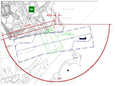
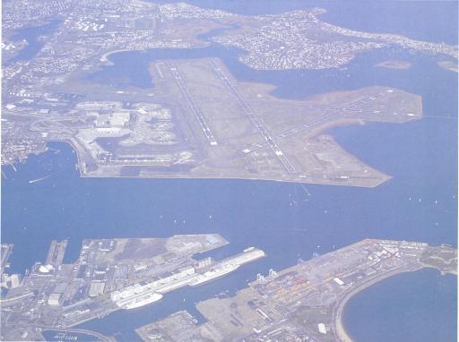
4 4L/22R 4R/22L W-Band Radar Site The W-Band Radar System at Boston s Logan Airport
5 Tx Chain Direct Digital Synthesizer upconverter x GHz SSPA T/R network Power splitter Phase Locked Oscillator Section Noise diode SP3T LNA Ambient Load Tx DDS trigger Rx Chain Direct Digital Synthesizer upconverter x GHz Rx DDS trigger Radar Control Board ADC trigger Down converter W-band Server (PC) node name: nereus 200 MS/s digitizer Radar echo Clock reference from radar Block Diagram of the W-Band Radar System.
6 RADAR ATTRIBUTES Secure Shelter located on the airfield Able to scan in azimuth and elevation (programmable) Ideally located for detection of wake vortices (RW4R/22L and RW4L/22R) Internet connectivity for continuous monitoring, data archiving and maintenance Reference Reflector for monitoring and gauging system performance Antenna is a Parabolic Cassegrain Feed with nominal gain of 59-dB and HPBW of 0.18 o ; 2-Way sidelobe suppression > 60-dB beyond ±3-beamwidths TX Signal is a long-duration, linear FM chirp waveform, with duration configurable from s
7 RADAR ATTRIBUTES RX Signal is multiplied by time-delayed RX local oscillator signal of the same slope in the modulation domain (f vs t) used for the TX Signal. Sampling is at 200- MHz-s -1, followed by first-level FFT processing to generate a range profile with 1-m range resolution (configurable) 20-kHz PRF yields an unambiguous Doppler velocity interval of ± 16-m-s -1 and allows for a large number of samples to be coherently integrated for improving sensitivity. The typical coherent integration length is 256 samples (512 and 1,024 also selectable), implemented by a secondlevel FFT at each range gate for Doppler processing. (Doppler velocity resolution ~0.12 m-s -1 ) Velocity spectra are power averaged to reduce fading
8 Parameter Frequency of Operation Peak Transmit Power Waveform Type Range Resolution Pulse Repetition Frequency Pulse Duration (min- max) Antenna Diameter & Type Antenna Beamwidth Antenna Gain Front-end Noise Figure Value GHz 100 mw Linear FM chirp 1.0 m 20 khz 1-10 s 48 Cassegrain 0.18 o 59 db 12 db W-Band Radar Specifications.

9 SAMPLE VALIDATION OF DOPPLER VELOCITY MEASUREMENTS

10 ASOS-based wind speed in the direction and at the height of the radar Doppler measurements were ~ m-s -1 in good agreement with the 10.7-m-s -1 average Doppler velocity measurement obtained from the measurements shown above. SAMPLE VALIDATION OF DOPPLER VELOCITY MEASUREMENTS
11 FIRST ATTEMPT TO DETECT WAKE VORTICES
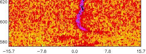
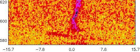
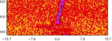
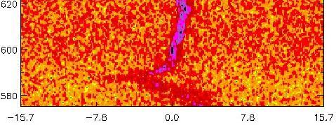
12 RELATIVE POWER DOPPLER VELOCITY First measurements of wake vortices made with the W-Band Radar on March 26, 2009 at Logan International Airport.
 GRIDS: HOR @ 5-m; VER")
13 ILLUSTRATION OF THE RADAR S SPATIAL RESOLUTION (3-m) GRIDS: 5-m; 5-m

14 COMPARISON OF RADAR MEASUREMENTS WITH A SIMULATED PAIR OF VORTICES, INCLUDING EFFECTS OF A CROSS WIND
15 RHI RELATIVE POWER PROFILE INDICATING BOTH REDUCED AND ENHANCED PRESENCE OF HYDROMETEORS RESULTING FROM THE PRESENCE OF THE WAKE VORTEX PAIR SHORTLY AFTER THEIR FORMATION (~28-s)

16 SIMILARITY OF CLOUD-BASED PHOTOGRAPH AND HYDROMETEOR- BASED RADAR RELATIVE POWER RESPONSE


17


18 05_05_ EDT 05_05_ EDT 05_05_ EDT Time history of wake vortices detected by the W-Band Radar on May 5, _05_ EDT
19 HIGH SIDE MID DOPPLER SPECTRA ALONG RADIALS PASSING THROUGH THE WAKE VORTEX PAIR May 5, LOW SIDE
20 Example of Doppler velocity spectra for a ray below (Low Side) the center of the vortex pair indicating considerably greater amounts of turbulence.


21 RANGE RESOLUTION = 3-m RANGE RESOLUTION = 60-m Simulated Illustration of the Differences in Doppler Velocity Spectra at Range Resolutions of 3- and 60-m.


22 Sample Doppler Spectra Obtained at a Range Resolution of 1-m


23 Sample Doppler Spectra of a Sequential Set of Rays Obtained at a Range Resolution of 1-m

24 SET OF WAKE VORTEX RHI PROFILES OBTAINED ON MARCH 29, THE WAKES WERE GENERATED BY AN AIRCRAFT LANDING ON RW04R AT LOGAN INTERNATIONAL AIRPORT
25 03_29_ EDT
26 03_29_ EDT
27 03_29_ EDT
28 03_29_ EDT
29 03_29_ EDT
30 03_29_ EDT

31 EXAMPLES OF READILY OBSERVED WAKE VORTEX - RELATED FEATURES OF INTEREST

32 03_29_ EDT CORE LOCATION BACKGROUND RADIAL WIND SPEED MEAN, VARIANCE, SPECTRAL FEATURES
33 SPATIAL DISTRIBUTION OF SCATTERERS 03_29_ EDT b 0 z

34 GROUND EFFECTS 03_29_ EDT
35 HORIZONTAL AND VERTICAL VELOCITIES dz 1 dy1 dt 10.7 ft s dz dt ft s 3.3m s 1 c m s 1 dz 2 dy2 dt 16.7 ft s dz2 6.2 dt ft s 1 c 1 5.1m s m s 1 dy 1 dy 2
36 RADIAL VELOCITY IN VICINITY OF WAKE 3.3 ms -1


37 Spatial Correlation of Power and Velocity Profiles for Insights into Understanding Related Physical Phenomena

38 POTENTIAL OF THE W-BAND RADAR SYSTEM FOR WAKE VORTEX RESEARCH AND AVIATION-RELEVANT APPLICATIONS
39 More precise understanding of the physics of wake behavior under landing and takeoff conditions. Basis for learning about differences in wake behavior in precipitation and non-precipitating regimes. Means of determining how hydrometeors of different types behave in complex flows such as wakes. Basis for understanding how atmospheric winds and boundary layer turbulence affect wake behavior. Means of ascertaining wake behavior caused by interactions with the ground (both solid and liquid), i.e., contrasting above ground level (AGL), near ground effect (NGE) and in ground effect (IGE). Detecting and characterizing wakes in low visibility conditions (rain/fog/haze). Investigations of other aircraft turbulence such as thrust stream turbulence (jet blast), propeller wash and rotor wash.

40 SOME ADDITIONAL TOPICS OF POSSIBLE RELEVANCE
41 Classifying differences in wake behavior as related to aircraft type, speed and weight. Improved understanding of differences in wakes and their behavior relative to aircraft type, speed, and atmospheric conditions. Contribute to improving rationale for ICAO and other standards for separation of aircraft. Contribute to standards for closely spaced parallel runways (less than 2,500-ft). Contribute to the evolution of new concepts of operations of airports. Provide valuable information on wake behavior that will help test the hypothesis that airport capacity can be safely increased through dynamic or standardized means of aircraft separations. Contribute to IFALPA concerns regarding: Safety Assurance; Testing and evaluation of airborne wake turbulence detection technologies; Ground-based detection of location, movement, intensity and duration of wake turbulence.; Ground-based detection of winds and atmospheric turbulence.
42 Investigating effects of flaps and their influence on the primary wake generation, their contribution to additional secondary wake formation and the subsequent interactions between primary and secondary wakes. Specific attributes of interest: core size (in to ft in diameter); speed of air movement inside the core (up to ~ 300-fps or 92-mps); extent of the outer region of the vortices (out to ~ 100-ft or 30-m); descent and ascent rates; and wake persistence or lifetimes. Improve understanding of the atmospheric environment that in turn can improve understanding of its effects on wake vortex behavior. Atmospheric parameters of interest include: ambient wind, turbulence, wind shear, thermal stratification and the presence of hydrometeors. Aviation-relevant mechanisms include: horizontal transport; downward vertical transport; vortex tube deformation or loss of vortex alignment; and wake vortex decay. Under Ground Influence horizontal transport is reduced; downward vertical transport is not effective or is reversed; vortex tube deformation is increased; and wake vortex decay is increased. Aviation-Relevant Concerns: functionality; stability; reliability; area of applicability; etc.

43 The design of the W-Band Radar is currently being enhanced for the US Department of Energy. This new system will provide dual polarization capabilities, mobility and TX power levels ~ 25-dB higher than the Logan Airport Radar. The company will also have a system of its own available to support a variety of field programs and experiments.
44 ProSensing is a systems engineering firm specializing in custom-built radar and radiometer systems for a wide range of remote sensing applications. ProSensing provides widespread expertise in electromagnetic scattering and propagation, microwave systems, antenna design, radiometric techniques, radar oceanography, radar meteorology, high speed data acquisition, digital signal processing and remote sensing systems. Our customers include government research laboratories, university research groups and large corporations in North America, Europe, and Asia.
45 Types of Sensor Systems W-Band Cloud Radars Ka-Band Cloud Radar X-Band Weather Radars L-Band Imaging Radiometer C-Band Stepped Frequency Microwave Radiometer Millimeter Wave (183 GHz) Water Vapor Radiometer Synthetic Aperture Radiometers Polarimetric Radars L-Band Salinity Mapper Digital Beamforming Antennas C-Band Scatterometer X-Band Ocean Surface Imaging Radar Ship Height Detection and Reporting Radar System


46 W-BAND CLOUD RADAR FMCW AIRBORNE RADAR MULTI-FREUENCY AIRBORNE RADAR (X-, Ka-,W-Band) STEPPED FREQUENCY MICROWAVE RADIOMETER ( GHz)
ATS 351 Lecture 9 Radar
 ATS 351 Lecture 9 Radar Radio Waves Electromagnetic Waves Consist of an electric field and a magnetic field Polarization: describes the orientation of the electric field. 1 Remote Sensing Passive vs Active
SODAR- sonic detecting and ranging
 Active Remote Sensing of the PBL Immersed vs. remote sensors Active vs. passive sensors RADAR- radio detection and ranging WSR-88D TDWR wind profiler SODAR- sonic detecting and ranging minisodar RASS RADAR
MOBILE RAPID-SCANNING X-BAND POLARIMETRIC (RaXPol) DOPPLER RADAR SYSTEM Andrew L. Pazmany 1 * and Howard B. Bluestein 2
 DOPPLER RADAR SYSTEM Andrew L. Pazmany 1 * and Howard B. Bluestein 2") 16B.2 MOBILE RAPID-SCANNING X-BAND POLARIMETRIC (RaXPol) DOPPLER RADAR SYSTEM Andrew L. Pazmany 1 * and Howard B. Bluestein 2 1 ProSensing Inc., Amherst, Massachusetts 2 University of Oklahoma, Norman,
16B.2 MOBILE RAPID-SCANNING X-BAND POLARIMETRIC (RaXPol) DOPPLER RADAR SYSTEM Andrew L. Pazmany 1 * and Howard B. Bluestein 2 1 ProSensing Inc., Amherst, Massachusetts 2 University of Oklahoma, Norman,
Development of Broadband Radar and Initial Observation
 Development of Broadband Radar and Initial Observation Tomoo Ushio, Kazushi Monden, Tomoaki Mega, Ken ichi Okamoto and Zen-Ichiro Kawasaki Dept. of Aerospace Engineering Osaka Prefecture University Osaka,
RPG-FMCW-94-SP Cloud Radar
 Latest Results from the RPG-FMCW-94-SP Cloud Radar (or, to stay in line with WG-3: a few slides on a 89 GHz radiometer with some active 94 GHz extensions to give the radiometer-derived LWP a bit more vertical
2B.6 SALIENT FEATURES OF THE CSU-CHILL RADAR X-BAND CHANNEL UPGRADE
 2B.6 SALIENT FEATURES OF THE CSU-CHILL RADAR X-BAND CHANNEL UPGRADE Francesc Junyent* and V. Chandrasekar, P. Kennedy, S. Rutledge, V. Bringi, J. George, and D. Brunkow Colorado State University, Fort
DETECTION OF SMALL AIRCRAFT WITH DOPPLER WEATHER RADAR
 DETECTION OF SMALL AIRCRAFT WITH DOPPLER WEATHER RADAR Svetlana Bachmann 1, 2, Victor DeBrunner 3, Dusan Zrnic 2 1 Cooperative Institute for Mesoscale Meteorological Studies, The University of Oklahoma
Microwave Remote Sensing (1)
") Microwave Remote Sensing (1) Microwave sensing encompasses both active and passive forms of remote sensing. The microwave portion of the spectrum covers the range from approximately 1cm to 1m in wavelength.
Microwave Remote Sensing (1) Microwave sensing encompasses both active and passive forms of remote sensing. The microwave portion of the spectrum covers the range from approximately 1cm to 1m in wavelength.
DOPPLER RADAR. Doppler Velocities - The Doppler shift. if φ 0 = 0, then φ = 4π. where
 Q: How does the radar get velocity information on the particles? DOPPLER RADAR Doppler Velocities - The Doppler shift Simple Example: Measures a Doppler shift - change in frequency of radiation due to
NCAR HIAPER Cloud Radar Design and Development
 NCAR HIAPER Cloud Radar Design and Development Pei-Sang Tsai, E. Loew, J. Vivekananadan, J. Emmett, C. Burghart, S. Rauenbuehler Earth Observing Laboratory, National Center for Atmospheric Research, Boulder,
A High Resolution and Precision Broad Band Radar
 A High Resolution and Precision Broad Band Radar Tomoo Ushio, T. Mega, T. Morimoto, Z-I. Kawasaki, and K. Okamoto Osaka University, Osaka, Japan INTRODUCTION Rainfall observations using weather radar have
Wave Sensing Radar and Wave Reconstruction
 Applied Physical Sciences Corp. 475 Bridge Street, Suite 100, Groton, CT 06340 (860) 448-3253 www.aphysci.com Wave Sensing Radar and Wave Reconstruction Gordon Farquharson, John Mower, and Bill Plant (APL-UW)
SYSTEM ARCHITECTURE OF RADAR NETWORK FOR MONITORING OF HAZARDOUD WEATHER
 SYSTEM ARCHITECTURE OF RADAR NETWORK FOR MONITORING OF HAZARDOUD WEATHER 2008. 11. 21 HOON LEE Gwangju Institute of Science and Technology &. CONTENTS 1. Backgrounds 2. Pulse Compression 3. Radar Network
4-10 Development of the CRL Okinawa Bistatic Polarimetric Radar
 4-10 Development of the CRL Okinawa Bistatic Polarimetric Radar NAKAGAWA Katsuhiro, HANADO Hiroshi, SATOH Shinsuke, and IGUCHI Toshio Communications Research Laboratory (CRL) has developed a new C-band
Radar Reprinted from "Waves in Motion", McGourty and Rideout, RET 2005
 Radar Reprinted from "Waves in Motion", McGourty and Rideout, RET 2005 What is Radar? RADAR (Radio Detection And Ranging) is a way to detect and study far off targets by transmitting a radio pulse in the
Mesoscale Atmospheric Systems. Radar meteorology (part 1) 04 March 2014 Heini Wernli. with a lot of input from Marc Wüest
 04 March 2014 Heini Wernli. with a lot of input from Marc Wüest") Mesoscale Atmospheric Systems Radar meteorology (part 1) 04 March 2014 Heini Wernli with a lot of input from Marc Wüest An example radar picture What are the axes? What is the resolution? What are the
Mesoscale Atmospheric Systems Radar meteorology (part 1) 04 March 2014 Heini Wernli with a lot of input from Marc Wüest An example radar picture What are the axes? What is the resolution? What are the
KA-BAND ARM ZENITH PROFILING RADAR NETWORK FOR CLIMATE STUDY
 A. KA-BAND ARM ZENITH PROFILING RADAR NETWORK FOR CLIMATE STUDY Nitin Bharadwaj 1, Andrei Lindenmaier 1, Kevin Widener 1, Karen Johnson, and Vijay Venkatesh 1 1 Pacific Northwest National Laboratory, Richland,
ORCSM: Online Remote Controlling And Status Monitoring of DWR
 ORCSM: Online Remote Controlling And Status Monitoring of DWR Ashwini D N M.Tech(CSE) IV sem VTU-CPGS Bangalore, India Shalini S Kumar M.Tech(CSE) IV sem VTU-CPGS Bangalore, India Abstract ORCSM is the
Acknowledgment. Process of Atmospheric Radiation. Atmospheric Transmittance. Microwaves used by Radar GMAT Principles of Remote Sensing
 GMAT 9600 Principles of Remote Sensing Week 4 Radar Background & Surface Interactions Acknowledgment Mike Chang Natural Resources Canada Process of Atmospheric Radiation Dr. Linlin Ge and Prof Bruce Forster
AIR ROUTE SURVEILLANCE 3D RADAR
 AIR TRAFFIC MANAGEMENT AIR ROUTE SURVEILLANCE 3D RADAR Supplying ATM systems around the world for more than 30 years indracompany.com ARSR-10D3 AIR ROUTE SURVEILLANCE 3D RADAR ARSR 3D & MSSR Antenna Medium
Next Generation Operational Met Office Weather Radars and Products
 Next Generation Operational Met Office Weather Radars and Products Pierre TABARY Jacques PARENT-DU-CHATELET Observing Systems Dept. Météo France Toulouse, France pierre.tabary@meteo.fr WakeNet Workshop,
Australian Wind Profiler Network and Data Use in both Operational and Research Environments
 Australian Wind Profiler Network and Data Use in both Operational and Research Environments Bronwyn Dolman 1,2 and Iain Reid 1,2 1 ATRAD Pty Ltd 20 Phillips St Thebarton South Australia www.atrad.com.au
Radar observables: Target range Target angles (azimuth & elevation) Target size (radar cross section) Target speed (Doppler) Target features (imaging)
 Target size (radar cross section) Target speed (Doppler) Target features (imaging)") Fundamentals of Radar Prof. N.V.S.N. Sarma Outline 1. Definition and Principles of radar 2. Radar Frequencies 3. Radar Types and Applications 4. Radar Operation 5. Radar modes What What is is Radar? Radar?
Fundamentals of Radar Prof. N.V.S.N. Sarma Outline 1. Definition and Principles of radar 2. Radar Frequencies 3. Radar Types and Applications 4. Radar Operation 5. Radar modes What What is is Radar? Radar?
P10.13 DEVELOPMENT AND APPLICATION OF A POLARIMETRIC X-BAND RADAR FOR MOBILE OR STATIONARY APPLICATIONS
 P10.13 DEVELOPMENT AND APPLICATION OF A POLARIMETRIC X-BAND RADAR FOR MOBILE OR STATIONARY APPLICATIONS Joerg Borgmann*, Ronald Hannesen, Peter Gölz and Frank Gekat Selex-Gematronik, Neuss, Germany Renzo
Introduction to Microwave Remote Sensing
 Introduction to Microwave Remote Sensing lain H. Woodhouse The University of Edinburgh Scotland Taylor & Francis Taylor & Francis Group Boca Raton London New York A CRC title, part of the Taylor & Francis
Weather Radar Systems. General Description
 General Description Our weather radars are designed for precipitation monitoring at both regional and urban scales. They can be advantageously used as gap filler of existing radar networks particularly
ELDES / METEK Weather Radar Systems. General Description
 General Description Our weather radars are designed for precipitation monitoring at both regional and urban scales. They can be advantageously used as gap fillers of existing radar networks particularly
DIGITAL BEAM-FORMING ANTENNA OPTIMIZATION FOR REFLECTOR BASED SPACE DEBRIS RADAR SYSTEM
 DIGITAL BEAM-FORMING ANTENNA OPTIMIZATION FOR REFLECTOR BASED SPACE DEBRIS RADAR SYSTEM A. Patyuchenko, M. Younis, G. Krieger German Aerospace Center (DLR), Microwaves and Radar Institute, Muenchner Strasse
CSU-CHILL Radar. Outline. Brief History of the Radar
 CSU-CHILL Radar October 12, 2009 Outline Brief history Overall Architecture Radar Hardware Transmitter/timing generator Microwave hardware (Frequency chain, front-end) Antenna Digital receiver Radar Software
INTRODUCTION TO RADAR SIGNAL PROCESSING
 INTRODUCTION TO RADAR SIGNAL PROCESSING Christos Ilioudis University of Strathclyde c.ilioudis@strath.ac.uk Overview History of Radar Basic Principles Principles of Measurements Coherent and Doppler Processing
Detection of Multipath Propagation Effects in SAR-Tomography with MIMO Modes
 Detection of Multipath Propagation Effects in SAR-Tomography with MIMO Modes Tobias Rommel, German Aerospace Centre (DLR), tobias.rommel@dlr.de, Germany Gerhard Krieger, German Aerospace Centre (DLR),
Chapter 41 Deep Space Station 13: Venus
 Chapter 41 Deep Space Station 13: Venus The Venus site began operation in Goldstone, California, in 1962 as the Deep Space Network (DSN) research and development (R&D) station and is named for its first
EE Chapter 14 Communication and Navigation Systems
 EE 2145230 Chapter 14 Communication and Navigation Systems Two way radio communication with air traffic controllers and tower operators is necessary. Aviation electronics or avionics: Avionic systems cover
Microwave Remote Sensing
 Provide copy on a CD of the UCAR multi-media tutorial to all in class. Assign Ch-7 and Ch-9 (for two weeks) as reading material for this class. HW#4 (Due in two weeks) Problems 1,2,3 and 4 (Chapter 7)
RECOMMENDATION ITU-R S.1340 *,**
 Rec. ITU-R S.1340 1 RECOMMENDATION ITU-R S.1340 *,** Sharing between feeder links the mobile-satellite service and the aeronautical radionavigation service in the Earth-to-space direction in the band 15.4-15.7
RANGE resolution and dynamic range are the most important
 INTL JOURNAL OF ELECTRONICS AND TELECOMMUNICATIONS, 2012, VOL. 58, NO. 2, PP. 135 140 Manuscript received August 17, 2011; revised May, 2012. DOI: 10.2478/v10177-012-0019-1 High Resolution Noise Radar
Space Frequency Coordination Group
 Space Frequency Coordination Group Report SFCG 38-1 POTENTIAL RFI TO EESS (ACTIVE) CLOUD PROFILE RADARS IN 94.0-94.1 GHZ FREQUENCY BAND FROM OTHER SERVICES Abstract This new SFCG report analyzes potential
A STUDY OF DOPPLER BEAM SWINGING USING AN IMAGING RADAR
 .9O A STUDY OF DOPPLER BEAM SWINGING USING AN IMAGING RADAR B. L. Cheong,, T.-Y. Yu, R. D. Palmer, G.-F. Yang, M. W. Hoffman, S. J. Frasier and F. J. López-Dekker School of Meteorology, University of Oklahoma,
FM cw Radar. FM cw Radar is a low cost technique, often used in shorter range applications"
 11: FM cw Radar 9. FM cw Radar 9.1 Principles 9.2 Radar equation 9.3 Equivalence to pulse compression 9.4 Moving targets 9.5 Practical considerations 9.6 Digital generation of wideband chirp signals FM
MULTI-CHANNEL SAR EXPERIMENTS FROM THE SPACE AND FROM GROUND: POTENTIAL EVOLUTION OF PRESENT GENERATION SPACEBORNE SAR
 3 nd International Workshop on Science and Applications of SAR Polarimetry and Polarimetric Interferometry POLinSAR 2007 January 25, 2007 ESA/ESRIN Frascati, Italy MULTI-CHANNEL SAR EXPERIMENTS FROM THE
BYU SAR: A LOW COST COMPACT SYNTHETIC APERTURE RADAR
 BYU SAR: A LOW COST COMPACT SYNTHETIC APERTURE RADAR David G. Long, Bryan Jarrett, David V. Arnold, Jorge Cano ABSTRACT Synthetic Aperture Radar (SAR) systems are typically very complex and expensive.
DYNAMO Aircraft Operations
 DYNAMO Aircraft Operations Aircraft: NOAA WP-3D, "Kermit" N42RF Flight hours: 105 science mission hours + 70 ferry hours Aircraft operation base: Diego Garcia (7.3 S, 72.5 E) Operation period: 45 days
Potential interference from spaceborne active sensors into radionavigation-satellite service receivers in the MHz band
 Rec. ITU-R RS.1347 1 RECOMMENDATION ITU-R RS.1347* Rec. ITU-R RS.1347 FEASIBILITY OF SHARING BETWEEN RADIONAVIGATION-SATELLITE SERVICE RECEIVERS AND THE EARTH EXPLORATION-SATELLITE (ACTIVE) AND SPACE RESEARCH
Remote Sensing. Ch. 3 Microwaves (Part 1 of 2)
") Remote Sensing Ch. 3 Microwaves (Part 1 of 2) 3.1 Introduction 3.2 Radar Basics 3.3 Viewing Geometry and Spatial Resolution 3.4 Radar Image Distortions 3.1 Introduction Microwave (1cm to 1m in wavelength)
Remote Sensing Ch. 3 Microwaves (Part 1 of 2) 3.1 Introduction 3.2 Radar Basics 3.3 Viewing Geometry and Spatial Resolution 3.4 Radar Image Distortions 3.1 Introduction Microwave (1cm to 1m in wavelength)
Radar. Seminar report. Submitted in partial fulfillment of the requirement for the award of degree Of Mechanical
 A Seminar report on Radar Submitted in partial fulfillment of the requirement for the award of degree Of Mechanical SUBMITTED TO: SUBMITTED BY: www.studymafia.org www.studymafia.org Preface I have made
HIGH FREQUENCY INTENSITY FLUCTUATIONS
 Proceedings of the Seventh European Conference on Underwater Acoustics, ECUA 004 Delft, The Netherlands 5-8 July, 004 HIGH FREQUENCY INTENSITY FLUCTUATIONS S.D. Lutz, D.L. Bradley, and R.L. Culver Steven
Introduction to Radar Systems. Radar Antennas. MIT Lincoln Laboratory. Radar Antennas - 1 PRH 6/18/02
 Introduction to Radar Systems Radar Antennas Radar Antennas - 1 Disclaimer of Endorsement and Liability The video courseware and accompanying viewgraphs presented on this server were prepared as an account
Educational Innovations in Radar Meteorology
 Educational Innovations in Radar Meteorology S. A. Rutledge Department of Atmospheric Science Colorado State University and V. Chandrasekar Department of Electrical and Computer Engineering Colorado State
Alessandro Battaglia 1, T. Augustynek 1, S. Tanelli 2 and P. Kollias 3
 Observing convection from space: assessment of performances for next- generation Doppler radars on Low Earth Orbit Alessandro Battaglia 1, T. Augustynek 1, S. Tanelli 2 and P. Kollias 3 1: University of
RECOMMENDATION ITU-R S.1341*
 Rec. ITU-R S.1341 1 RECOMMENDATION ITU-R S.1341* SHARING BETWEEN FEEDER LINKS FOR THE MOBILE-SATELLITE SERVICE AND THE AERONAUTICAL RADIONAVIGATION SERVICE IN THE SPACE-TO-EARTH DIRECTION IN THE BAND 15.4-15.7
328 IMPROVING POLARIMETRIC RADAR PARAMETER ESTIMATES AND TARGET IDENTIFICATION : A COMPARISON OF DIFFERENT APPROACHES
 328 IMPROVING POLARIMETRIC RADAR PARAMETER ESTIMATES AND TARGET IDENTIFICATION : A COMPARISON OF DIFFERENT APPROACHES Alamelu Kilambi 1, Frédéric Fabry, Sebastian Torres 2 Atmospheric and Oceanic Sciences,
C- and Ku-band, dual-frequency, multi-polarization, combined scatterometer-radiometer system for sea, land, and atmospheric remote sensing
 C- Ku-b dual-frequency multi-polarization combined scatterometer-radiometer system for sea l atmospheric remote sensing Artashes K. Arakelyan* Astghik K. Hambaryan Vanik V. Karyan Melanya L. Grigoryan
Scalable Ionospheric Analyser SIA 24/6
 Scalable Ionospheric Analyser SIA 24/6 Technical Overview Functional description The ATRAD Scalable Ionospheric Analyser SIA24/6 is designed to observe ionospheric irregularities and their drift in the
RADAR DEVELOPMENT BASIC CONCEPT OF RADAR WAS DEMONSTRATED BY HEINRICH. HERTZ VERIFIED THE MAXWELL RADAR.
 1 RADAR WHAT IS RADAR? RADAR (RADIO DETECTION AND RANGING) IS A WAY TO DETECT AND STUDY FAR OFF TARGETS BY TRANSMITTING A RADIO PULSE IN THE DIRECTION OF THE TARGET AND OBSERVING THE REFLECTION OF THE
Radar-Verfahren und -Signalverarbeitung
 Radar-Verfahren und -Signalverarbeitung - Lesson 2: RADAR FUNDAMENTALS I Hon.-Prof. Dr.-Ing. Joachim Ender Head of Fraunhoferinstitut für Hochfrequenzphysik and Radartechnik FHR Neuenahrer Str. 20, 53343
The Delay-Doppler Altimeter
 Briefing for the Coastal Altimetry Workshop The Delay-Doppler Altimeter R. K. Raney Johns Hopkins University Applied Physics Laboratory 05-07 February 2008 1 What is a Delay-Doppler altimeter? Precision
The Impact of Very High Frequency Surface Reverberation on Coherent Acoustic Propagation and Modeling
 DISTRIBUTION STATEMENT A. Approved for public release; distribution is unlimited. The Impact of Very High Frequency Surface Reverberation on Coherent Acoustic Propagation and Modeling Grant B. Deane Marine
Multifunction Phased Array Radar Advanced Technology Demonstrator
 Multifunction Phased Array Radar Advanced Technology Demonstrator David Conway Sponsors: Mike Emanuel, FAA ANG-C63 Kurt Hondl, NSSL Multifunction Phased Array Radar (MPAR) for Aircraft and Weather Surveillance
Fundamental Concepts of Radar
 Fundamental Concepts of Radar Dr Clive Alabaster & Dr Evan Hughes White Horse Radar Limited Contents Basic concepts of radar Detection Performance Target parameters measurable by a radar Primary/secondary
Study of Polarimetric Calibration for Circularly Polarized Synthetic Aperture Radar
 Study of Polarimetric Calibration for Circularly Polarized Synthetic Aperture Radar 2016.09.07 CEOS WORKSHOP 2016 Yuta Izumi, Sevket Demirci, Mohd Zafri Baharuddin, and Josaphat Tetuko Sri Sumantyo JOSAPHAT
Project: 3.8M Series 1385 Ku-Band Rx/Tx System. General Dynamics SATCOM Technologies
 Antenna Test Report Test No. 1761 Project: 3.8M Series 1385 Ku-Band Rx/Tx System. SATCOM Technologies East Maiden Antenna Test Facility 4488 Lawing Chapel Church Road Maiden, North Carolina 2865 828-428-1485
Radar Systems Engineering Lecture 12 Clutter Rejection
 Radar Systems Engineering Lecture 12 Clutter Rejection Part 1 - Basics and Moving Target Indication Dr. Robert M. O Donnell Guest Lecturer Radar Systems Course 1 Block Diagram of Radar System Transmitter
Scalable Front-End Digital Signal Processing for a Phased Array Radar Demonstrator. International Radar Symposium 2012 Warsaw, 24 May 2012
 Scalable Front-End Digital Signal Processing for a Phased Array Radar Demonstrator F. Winterstein, G. Sessler, M. Montagna, M. Mendijur, G. Dauron, PM. Besso International Radar Symposium 2012 Warsaw,
RF and Microwave Test and Design Roadshow 5 Locations across Australia and New Zealand
 RF and Microwave Test and Design Roadshow 5 Locations across Australia and New Zealand ni.com Design and test of RADAR systems Agenda Radar Overview Tools Overview VSS LabVIEW PXI Design and Simulation
THE NASA/JPL AIRBORNE SYNTHETIC APERTURE RADAR SYSTEM. Yunling Lou, Yunjin Kim, and Jakob van Zyl
 THE NASA/JPL AIRBORNE SYNTHETIC APERTURE RADAR SYSTEM Yunling Lou, Yunjin Kim, and Jakob van Zyl Jet Propulsion Laboratory California Institute of Technology 4800 Oak Grove Drive, MS 300-243 Pasadena,
RADAR CHAPTER 3 RADAR
 RADAR CHAPTER 3 RADAR RDF becomes Radar 1. As World War II approached, scientists and the military were keen to find a method of detecting aircraft outside the normal range of eyes and ears. They found
Corresponding author address: Valery Melnikov, 1313 Haley Circle, Norman, OK,
 2.7 EVALUATION OF POLARIMETRIC CAPABILITY ON THE RESEARCH WSR-88D Valery M. Melnikov *, Dusan S. Zrnic **, John K. Carter **, Alexander V. Ryzhkov *, Richard J. Doviak ** * - Cooperative Institute for
Investigations on the performance of lidar measurements with different pulse shapes using a multi-channel Doppler lidar system
 Th12 Albert Töws Investigations on the performance of lidar measurements with different pulse shapes using a multi-channel Doppler lidar system Albert Töws and Alfred Kurtz Cologne University of Applied
Design and Development of a Ground-based Microwave Radiometer System
 PIERS ONLINE, VOL. 6, NO. 1, 2010 66 Design and Development of a Ground-based Microwave Radiometer System Yu Zhang 1, 2, Jieying He 1, 2, and Shengwei Zhang 1 1 Center for Space Science and Applied Research,
CLOUDSDR RFSPACE #CONNECTED SOFTWARE DEFINED RADIO. final design might vary without notice
 CLOUDSDR #CONNECTED SOFTWARE DEFINED RADIO final design might vary without notice 1 - PRELIMINARY SPECIFICATIONS http://www.rfspace.com v0.1 RFSPACE CloudSDR CLOUDSDR INTRODUCTION The RFSPACE CloudSDR
Nuove tecnologie per ecografia ad ultrasuoni: da 2D a 4D
 DINFO Dipartimento di Ingegneria dell Informazione Department of Information Engineering Nuove tecnologie per ecografia ad ultrasuoni: da 2D a 4D Piero Tortoli Microelectronics Systems Design Lab 1 Introduction
MAKING TRANSIENT ANTENNA MEASUREMENTS
 MAKING TRANSIENT ANTENNA MEASUREMENTS Roger Dygert, Steven R. Nichols MI Technologies, 1125 Satellite Boulevard, Suite 100 Suwanee, GA 30024-4629 ABSTRACT In addition to steady state performance, antennas
P12R.14 A NEW C-BAND POLARIMETRIC RADAR WITH SIMULTANEOUS TRANSMISSION FOR HYDROMETEOR CLASSIFICATION AND RAINFALL MEASUREMENT
 P12R.14 A NEW C-BAND POLARIMETRIC RADAR WITH SIMULTANEOUS TRANSMISSION FOR HYDROMETEOR CLASSIFICATION AND RAINFALL MEASUREMENT J. William Conway 1, *, Dean Nealson 2, James J. Stagliano 2, Alexander V.
Unique Capabilities. Multifunction Phased-Array Radar Symposium Phased-Array Radar Workshop. 17 November, 2009
 Phased-Array Radar Unique Capabilities Dr. Sebastián Torres CIMMS /The University of Oklahoma and National Severe Storms Laboratory/NOAA Multifunction Phased-Array Radar Symposium Phased-Array Radar Workshop
Terahertz radar imaging for standoff personnel screening
 Terahertz radar imaging for standoff personnel screening European Microwave Conference, October 211 Ken Cooper Submillimeter-Wave Advanced Technology (SWAT) Team NASA Jet Propulsion Laboratory California
Multifunction Phased Array
 Multifunction Phased Array Radar (MPAR) John Cho 18 November 2014 Sponsors: Michael Emanuel, FAA Advanced Concepts and Technology Development (ANG-C63) Kurt Hondl, NOAA National Severe Storms Laboratory
Profiling Radiometer for Atmospheric and Cloud Observations PRACO
 Profiling Radiometer for Atmospheric and Cloud Observations PRACO Boulder Environmental Sciences and Technology BEST Small startup company, established in 2006 Focused on radiometry ground based and airborne
RPG-MWR-PRO-TN Page 1 / 12 Radiometer Physics GmbH
 Applications Tropospheric profiling of temperature, humidity and liquid water High-resolution boundary layer temperature profiles, better resolution than balloons Input for weather and climate models (data
RAPTOR TM Radar Wind Profiler Models
 Radiometrics, Corp. 4909 Nautilus Court North, Suite 110 Boulder, CO 80301 USA T (303) 449-9192 www.radiometrics.com RAPTOR TM Radar Wind Profiler Models Radiometrics, Corp. designs and manufactures a
Lecture 9. Radar Equation. Dr. Aamer Iqbal. Radar Signal Processing Dr. Aamer Iqbal Bhatti
 Lecture 9 Radar Equation Dr. Aamer Iqbal 1 ystem Losses: Losses within the radar system itself are from many sources. everal are described below. L PL =the plumbing loss. L PO =the polarization loss. L
Sea surface temperature observation through clouds by the Advanced Microwave Scanning Radiometer 2
 Sea surface temperature observation through clouds by the Advanced Microwave Scanning Radiometer 2 Akira Shibata Remote Sensing Technology Center of Japan (RESTEC) Tsukuba-Mitsui blds. 18F, 1-6-1 Takezono,
IBIS range. GeoRadar Division. GeoRadar Division. Static and Dynamic Monitoring of Civil Engineering Structures by Microwave Interferometry
 Static and Dynamic Monitoring of Civil Engineering Structures by Microwave Interferometry Garry Spencer and Mark Bell 1 PRODUCTS IBIS range APPLICATIONS IBIS - FL LANDSLIDE & DAM MONITORING IBIS - FM SLOPE
Setup of the four-wavelength Doppler lidar system with feedback controlled pulse shaping
 Setup of the four-wavelength Doppler lidar system with feedback controlled pulse shaping Albert Töws and Alfred Kurtz Cologne University of Applied Sciences Steinmüllerallee 1, 51643 Gummersbach, Germany
Rec. ITU-R P RECOMMENDATION ITU-R P *
 Rec. ITU-R P.682-1 1 RECOMMENDATION ITU-R P.682-1 * PROPAGATION DATA REQUIRED FOR THE DESIGN OF EARTH-SPACE AERONAUTICAL MOBILE TELECOMMUNICATION SYSTEMS (Question ITU-R 207/3) Rec. 682-1 (1990-1992) The
Subsystems of Radar and Signal Processing and ST Radar
 Advance in Electronic and Electric Engineering. ISSN 2231-1297, Volume 3, Number 5 (2013), pp. 531-538 Research India Publications http://www.ripublication.com/aeee.htm Subsystems of Radar and Signal Processing
Civil Radar Systems.
 Civil Radar Systems www.aselsan.com.tr Civil Radar Systems With extensive radar heritage exceeding 20 years, ASELSAN is a new generation manufacturer of indigenous, state-of-theart radar systems. ASELSAN
NEW STRATOSPHERE-TROPOSPHERE RADAR WIND PROFILER FOR NATIONAL NETWORKS AND RESEARCH
 NEW STRATOSPHERE-TROPOSPHERE RADAR WIND PROFILER FOR NATIONAL NETWORKS AND RESEARCH Scott A. McLaughlin, Bob L. Weber, David A. Merritt, Gary A. Zimmerman, Maikel L. Wise, Frank Pratte DeTect, Inc. 117-L
Introduction to: Radio Navigational Aids
 Introduction to: Radio Navigational Aids 1 Lecture Topics Basic Principles Radio Directional Finding (RDF) Radio Beacons Distance Measuring Equipment (DME) Instrument Landing System (ILS) Microwave Landing
Incoherent Scatter Experiment Parameters
 Incoherent Scatter Experiment Parameters At a fundamental level, we must select Waveform type Inter-pulse period (IPP) or pulse repetition frequency (PRF) Our choices will be dictated by the desired measurement
Lecture Topics. Doppler CW Radar System, FM-CW Radar System, Moving Target Indication Radar System, and Pulsed Doppler Radar System
 Lecture Topics Doppler CW Radar System, FM-CW Radar System, Moving Target Indication Radar System, and Pulsed Doppler Radar System 1 Remember that: An EM wave is a function of both space and time e.g.
New and Emerging Technologies
 New and Emerging Technologies Edwin E. Herricks University of Illinois Center of Excellence for Airport Technology (CEAT) Airport Safety Management Program (ASMP) Reality Check! There are no new basic
Passive Microwave Sensors LIDAR Remote Sensing Laser Altimetry. 28 April 2003
 Passive Microwave Sensors LIDAR Remote Sensing Laser Altimetry 28 April 2003 Outline Passive Microwave Radiometry Rayleigh-Jeans approximation Brightness temperature Emissivity and dielectric constant
THE FRONT RANGE PILOT PROJECT FOR GPM: AN INSTRUMENT AND CONCEPT TEST
 P6R.2 THE FRONT RANGE PILOT PROJECT FOR GPM: AN INSTRUMENT AND CONCEPT TEST S. A. Rutledge* 1, R. Cifelli 1, T. Lang 1, S. Nesbitt 1, K. S. Gage 2, C. R. Williams 2,3, B. Martner 2,3, S. Matrosov 2,3,
Active microwave systems (1) Satellite Altimetry
 Satellite Altimetry") Remote Sensing: John Wilkin Active microwave systems (1) Satellite Altimetry jwilkin@rutgers.edu IMCS Building Room 214C 732-932-6555 ext 251 Active microwave instruments Scatterometer (scattering from
Remote Sensing: John Wilkin Active microwave systems (1) Satellite Altimetry jwilkin@rutgers.edu IMCS Building Room 214C 732-932-6555 ext 251 Active microwave instruments Scatterometer (scattering from
SPECTRASAT INSTRUMENT DESIGN USING MAXIMUM HERITAGE
 JOHN L. MacARTHUR SPECTRASAT INSTRUMENT DESIGN USING MAXIMUM HERITAGE Recent developments in altimeter design for NASA's Ocean Topography Experiment and the Navy's Remote Ocean Sensing System have included
Mobile System for Remote Sensing of Wind, Humidity, Temperature and Precipitation Microstructure Profiles during Special Events and Sport Competitions
 Mobile System for Remote Sensing of Wind, Humidity, Temperature and Precipitation Microstructure Profiles during Special Events and Sport Competitions Introduction By Alexander Gusev, Viktor Ignatov, Arkadiy
Digital Sounder: HF Diagnostics Module:Ionosonde Dual Channel ( ) Eight Channel ( )
 Eight Channel ( )") CENTER FOR REMOTE SE NSING, INC. Digital Sounder: HF Diagnostics Module:Ionosonde Dual Channel (001-2000) Eight Channel (004-2006) 2010 Center for Remote Sensing, Inc. All specifications subject to change
CENTER FOR REMOTE SE NSING, INC. Digital Sounder: HF Diagnostics Module:Ionosonde Dual Channel (001-2000) Eight Channel (004-2006) 2010 Center for Remote Sensing, Inc. All specifications subject to change
Detection and Identification of Remotely Piloted Aircraft Systems Using Weather Radar
 Microwave Remote Sensing Laboratory Detection and Identification of Remotely Piloted Aircraft Systems Using Weather Radar Krzysztof Orzel1 Siddhartan Govindasamy2, Andrew Bennett2 David Pepyne1 and Stephen
Observed Extinction by Clouds at 95 GHz
 TGARS 98 1 Observed Extinction by Clouds at 95 GHz Gabor Vali and Samuel Haimov Abstract: Measurements of backscattered power were made in maritime stratus with a 95 GHz pulsed radar mounted on an aircraft.
RECOMMENDATION ITU-R SA.1628
 Rec. ITU-R SA.628 RECOMMENDATION ITU-R SA.628 Feasibility of sharing in the band 35.5-36 GHZ between the Earth exploration-satellite service (active) and space research service (active), and other services