New and Emerging Technologies
|
|
|
- Rodger Cain
- 5 years ago
- Views:
Transcription
1 New and Emerging Technologies Edwin E. Herricks University of Illinois Center of Excellence for Airport Technology (CEAT) Airport Safety Management Program (ASMP)
2 Reality Check! There are no new basic technologies available for wildlife management! There are new and innovative applications of existing technologies that are improving wildlife management! Wildlife management elements benefiting from technology: Habitat assessment Birds and other wildlife target detection Data/Information/User Interfaces
3 Technology categories: I will focus on these technology categories today: Radio frequency Radar Light Lidar CCD/EO cameras, image enhancement Thermal Data Management, Information Flow Analytics, Modeling, Machine learning User Interfaces
4 Wildlife management presents a complex system of varying needs with multiple paths for technology application. In general, in airport applications the emphasis is on solution of specific problems where there is an unfortunate mismatch between expectations of what the technology will do and what the technology can actually do (particularly at low cost!).
5 New opportunities for technology use in wildlife management exist when need is specifically matched with capability. A cautionary note, we must not overlook the utility of technologies designed for purposes other than wildlife management (e.g. FOD detection) and potential for integration of existing safety technologies in wildlife management.
6 Our focus today is on technologies for wildlife management, which in my experience, means different things to different players in the airport game. For airport wildlife managers it means improving management success to advance safety. For most other airport professionals, and the public, it means stopping bird strikes.
7 Improving safety using wildlife management techniques may challenge technology but applicable systems tend to maintain/require a strong human interface and have longer time frames for application (hours to seasons) placing less emphasis on sense and alert. In wildlife management technology provides a valuable supplement to wildlife management activities.
8 Stopping bird strikes has stringent timing and accuracy requirements that stretch the capabilities of sensor systems. Stringent requirements lead to automation, short response times, and low to absent false alarm rates. In addition human operators must still be in the loop as decision makers. This is complicated! Let me state very clearly at this point in time technology will not stop wildlife/aircraft collisions not a silver bullet!
9 Let s consider the state-of-the-art and new developments What I will now do is present an incomplete review of new technologies, or innovative applications of existing technologies, in wildlife management. I can only provide limited detail to meet presentation time limits.
10 Habitat A critical part of wildlife management is understanding what habitat is where in relation to aircraft movements. A number of tools are available here. The spatial characterization of habitat is achieved through a wide range of geographic information sciences tools.


11 Satellite-based remote sensing: Long history but new satellites and new imaging technologies supplement long standing imagery.

12 Multispectral imaging: Now available from aircraft at lower altitudes with military technology now commercially available. Full bandwidth Infared
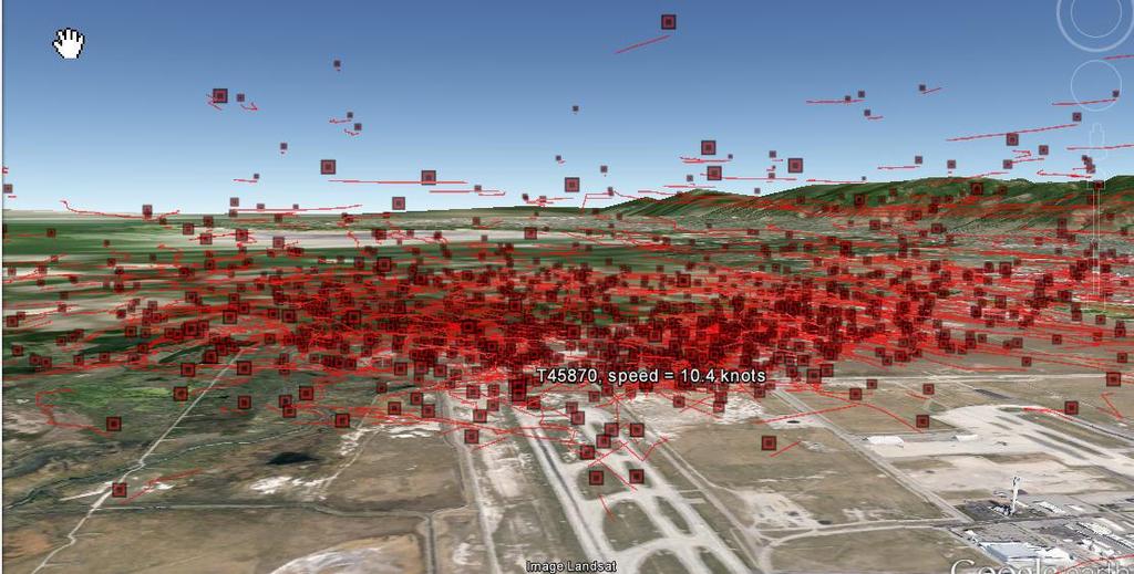
13 Capabilities exist to classify habitat using remote sensing to identify attractants for management focus AES Habitat Classifications and CEAT Observation Locations!( North Ü Miles!( West Radar!(!( ObservationPt Comb_habitat HabitatClass 1- Very Likely Foraging Habitat 2- Likely Foraging Habitat 3- Potential Foraging or Resting Habitat 4- Not Likely Foraging Habitat 5- Not Likely Foraging Habitat- Vegetation 6- Not Likely Foraging Habitat- Tall Vegetation 7- Impervious 8- Tree or Shrub 9- Herbaceous/Grass


14 It is also possible to actually count wildlife numbers. Here American White Pelican on Gunnison Island, UT. 3 inch resolution infrared


15 Lidar: There is an extensive literature on the use of Lidar for habitat assessment. From reporting of the Sierra Nevada Adaptive Management Project, University of California, Berkeley


16 GIS technologies are now very advanced providing opportunities to layer data in spatial analyses for wildlife management.

17 Net-based access is now available for an amazing array of habitat and wildlife data using GIS tools!
18 Birds and Wildlife Two primary sensor types are used for wildlife (primarily bird) surveillance - radar and optical/thermal cameras. Systems using these sensors are the foundation for new technological applications in wildlife management.
19 Operational requirements for wildlife management that technologies must meet include surveillance for birds of varying size and behavior over a range of scales from the airport to regions. No single sensor type or design is available to meet local to regional scale requirements for wildlife management, but multiple sensors can be integrated, even fused, to provide a comprehensive picture of wildlife activity. Integration/fusion of multiple sensors is the future!
20 Radar Different radar types provide surveillance over multiple scales (airport, commuter, migration) supporting detection and tracking in 3-dimensions. New radars include new hardware based on advanced solid state electronics coupled with sophisticated antenna configurations and innovative software providing data management and sophisticated user interfaces.


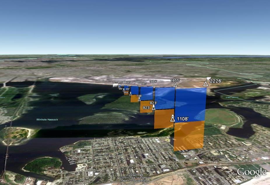
21 1 n m ft 2 n m n0 mft 4 n m Vertical overlap Horiz ontal overla p


22 A critical characteristic of radar is coverage produced by antenna design. Today dish and array antennas Tomorrow phased array antenna patterns
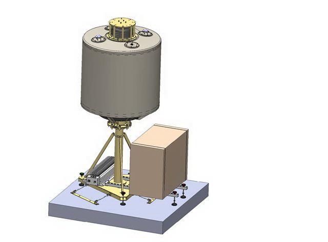
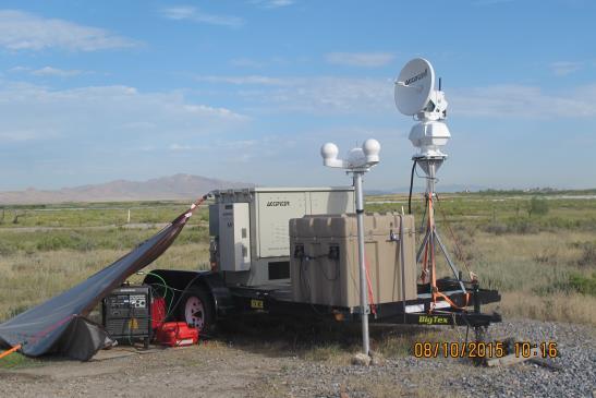
23 There have been major advances in weather radars providing new tools for wildlife management at a regional scale. Within the last decade the network of WSR-88D radars has received two major upgrades that greatly improve the monitoring of the movements of animals in the atmosphere: Super-resolution Dual-polarization
24 Super-resolution Resolution cells [pulse volumes] of all products are 0.5 in azimuth and 250 m in range. Dual polarization Simultaneous transmission of orthogonally oriented pulses added to the original radar products (base reflectivity, radial velocity, and spectrum width). Three new moments of return: differential reflectivity, correlation coefficient, and differential phase.
25 NOAA uses the three dual-polarization moments to discriminate different types of meteorological scatterers using hydrometeor classification algorithms (HCA), and discriminate between meteorological and biological scatterers.


26 These are examples of NEXRAD products commonly used today. Reflectivity Hydrometeor Classification


27 These are examples of NEXRAD data filtering using dual polarization to identify roost departures. unfiltered filtered max 4 unfiltered filtered min 100 deg
28 Weather radars operate over regional scales, but airport coverage may exist. This is an example of NEXRAD coverage for ORD.

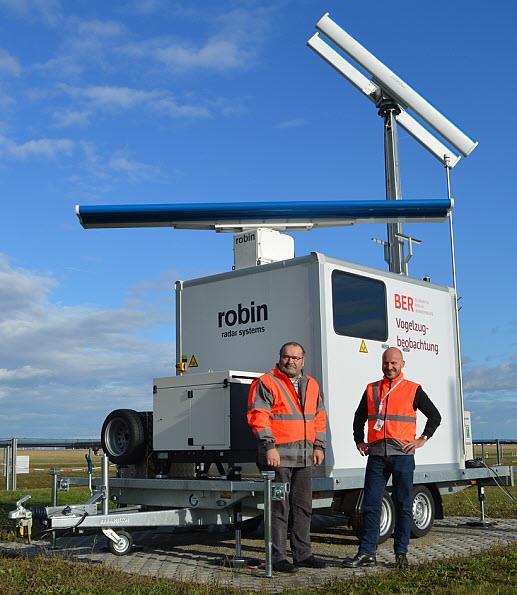
29 Weather radars operate over regional scales, but airport coverage may exist. This is an example of NEXRAD coverage for ORD.
30 Radars of major local interest to wildlife managers are avian radar systems designed to cover 6 mile range and 3000 ft altitude. Legacy systems use magnetron-based scanners with array or dish antennas. Advanced solid state systems include Doppler resolution and offer advanced antenna designs, including phased array antennas.


31 Legacy array and dish antenna coverage


32 Typical displays of radar data

33 Radar data summaries

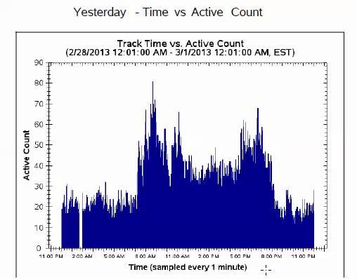
34 New antenna configurations provide information on location and altitude. Used with permission of Accipiter Radar Technologies, Inc.

35 Phased array antennas on avian radar systems provide location and altitude information at high resolution. These antennas also address cone of silence issues.
36 A major disadvantage of radar is that limited information is available for target identification. Optical and thermal systems address this issue by providing Used with permission SRC an image that can be recognized by even untrained personnel as a bird. Used with permission of Robin Radar


37 There are new bird detection systems incorporating electro optical and thermal cameras. Interceptor from Pharovision NEC Bird Detection Camera System

38 Example Interceptor display

39 Example NEC Bird Detection Camera System Display
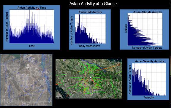
40 Data/Information/User Interfaces Technology develops data that is then processed into information. It is information that wildlife managers need! There have been many innovations in information extraction from data and in the development of user interfaces. Vendors are meeting customer specific requirements.

41 User displays summarize data and provide easy methods to access data archives.
42


43 Near Misses Last 7 days Runway Crossings per hour previous day Used with permission Robin Radar

44 Information content of displays can be readily adapted to user needs or analysis requirements.


45 An operational system at SEA is the Threat Viewer. Using avian radar data this system alerts airport personnel to the persistence of bird activity on the airport. This is a model of future airport radar applications.
46 Reality Check II! Technology is expensive and problem solutions complex. Technology is not easy and will require a personnel commitment! Single use systems will lose favor to airport wildlife management technologies that integrate existing safety technologies where possible. Example FOD Detection

47 In the first operational FOD detection systems wildlife was regularly detected on runways. I have found 60% of alerts at SIN due to wildlife. SEA has been integrating their FOD detection system in wildlife management.


48 SEA personnel have used FOD detection data in a number of ways. Accounting for bird distribution and possibly food resources worms. Immediately detecting remains and assigning a strike to a specific aircraft.
49 Don t forget UAS! Not only can UAS technologies benefit wildlife management by flying cameras or harassing wildlife, it is clear that the present emphasis on UAS detection is advancing detection technology that integrates radar and optical sensors. We can expect significant improvement in bird radars because birds and drones present similar detection problems in fact birds are clutter in UAS detection!
50 In summary: There is little new in basic technology but there are exciting new applications of technology systems. These systems are available now, or soon will be, in wildlife management. We must not ignore existing surveillance technologies nor fail to take advantage of technologies deployed to address other safety problems.
51 In wildlife management, technology is a tool, not a solution. Considering technology-based tools in wildlife management we must consider: application needs, design, cost (acquisition and operation), user acceptance. We need to know whether we have: A technology looking for a problem A problem defining the technology.

52 Questions?????
Sources of Geographic Information
 Sources of Geographic Information Data properties: Spatial data, i.e. data that are associated with geographic locations Data format: digital (analog data for traditional paper maps) Data Inputs: sampled
DETECTION OF SMALL AIRCRAFT WITH DOPPLER WEATHER RADAR
 DETECTION OF SMALL AIRCRAFT WITH DOPPLER WEATHER RADAR Svetlana Bachmann 1, 2, Victor DeBrunner 3, Dusan Zrnic 2 1 Cooperative Institute for Mesoscale Meteorological Studies, The University of Oklahoma
INTEGRATIVE MIGRATORY BIRD MANAGEMENT ON MILITARY BASES: THE ROLE OF RADAR ORNITHOLOGY
 INTEGRATIVE MIGRATORY BIRD MANAGEMENT ON MILITARY BASES: THE ROLE OF RADAR ORNITHOLOGY Sidney A. Gauthreaux, Jr. and Carroll G. Belser Department of Biological Sciences Clemson University Clemson, SC 29634-0314
3-D Radar Sampling Methods for Ornithology and Wildlife Management
 University of Nebraska - Lincoln DigitalCommons@University of Nebraska - Lincoln 2011 Bird Strike North America Conference, Niagara Falls Bird Strike Committee Proceedings 9-2011 3-D Radar Sampling Methods
Using Freely Available. Remote Sensing to Create a More Powerful GIS
 Using Freely Available Government Data and Remote Sensing to Create a More Powerful GIS All rights reserved. ENVI, E3De, IAS, and IDL are trademarks of Exelis, Inc. All other marks are the property of
Module 3 Introduction to GIS. Lecture 8 GIS data acquisition
 Module 3 Introduction to GIS Lecture 8 GIS data acquisition GIS workflow Data acquisition (geospatial data input) GPS Remote sensing (satellites, UAV s) LiDAR Digitized maps Attribute Data Management Data
Civil Radar Systems.
 Civil Radar Systems www.aselsan.com.tr Civil Radar Systems With extensive radar heritage exceeding 20 years, ASELSAN is a new generation manufacturer of indigenous, state-of-theart radar systems. ASELSAN
SODAR- sonic detecting and ranging
 Active Remote Sensing of the PBL Immersed vs. remote sensors Active vs. passive sensors RADAR- radio detection and ranging WSR-88D TDWR wind profiler SODAR- sonic detecting and ranging minisodar RASS RADAR
Microwave Remote Sensing (1)
") Microwave Remote Sensing (1) Microwave sensing encompasses both active and passive forms of remote sensing. The microwave portion of the spectrum covers the range from approximately 1cm to 1m in wavelength.
Microwave Remote Sensing (1) Microwave sensing encompasses both active and passive forms of remote sensing. The microwave portion of the spectrum covers the range from approximately 1cm to 1m in wavelength.
ATS 351 Lecture 9 Radar
 ATS 351 Lecture 9 Radar Radio Waves Electromagnetic Waves Consist of an electric field and a magnetic field Polarization: describes the orientation of the electric field. 1 Remote Sensing Passive vs Active
Microwave Remote Sensing
 Provide copy on a CD of the UCAR multi-media tutorial to all in class. Assign Ch-7 and Ch-9 (for two weeks) as reading material for this class. HW#4 (Due in two weeks) Problems 1,2,3 and 4 (Chapter 7)
A COMPUTER VISION AND MACHINE LEARNING SYSTEM FOR BIRD AND BAT DETECTION AND FORECASTING
 A COMPUTER VISION AND MACHINE LEARNING SYSTEM FOR BIRD AND BAT DETECTION AND FORECASTING Russell Conard Wind Wildlife Research Meeting X December 2-5, 2014 Broomfield, CO INTRODUCTION Presenting for Engagement
Remote Sensing of Turbulence: Radar Activities. FY00 Year-End Report
 Remote Sensing of Turbulence: Radar Activities FY Year-End Report Submitted by The National Center For Atmospheric Research Deliverable.7.3.E3 Introduction In FY, NCAR was given Technical Direction by
Characteristics and protection criteria for radars operating in the aeronautical radionavigation service in the frequency band
 Recommendation ITU-R M.2008 (03/2012) Characteristics and protection criteria for radars operating in the aeronautical radionavigation service in the frequency band 13.25-13.40 GHz M Series Mobile, radiodetermination,
Detection and Identification of Remotely Piloted Aircraft Systems Using Weather Radar
 Microwave Remote Sensing Laboratory Detection and Identification of Remotely Piloted Aircraft Systems Using Weather Radar Krzysztof Orzel1 Siddhartan Govindasamy2, Andrew Bennett2 David Pepyne1 and Stephen
Current stage of bird radar systems Felix Liechti, Swiss Ornithological Institute Hans van Gasteren, Royal Airforce of The Netherlands
 Current stage of bird radar systems Felix Liechti, Swiss Ornithological Institute Hans van Gasteren, Royal Airforce of The Netherlands IBSC Cairns 2010 Swiss Ornithological Institute a private foundation
MPA Baseline Program. Annual Progress Report
 MPA Baseline Program Annual Progress Report Principal Investigators please use this form to submit your MPA Baseline Program project annual report, including an update on activities completed over the
Operation of a Mobile Wind Profiler In Severe Clutter Environments
 1. Introduction Operation of a Mobile Wind Profiler In Severe Clutter Environments J.R. Jordan, J.L. Leach, and D.E. Wolfe NOAA /Environmental Technology Laboratory Boulder, CO Wind profiling radars have
Corresponding author address: Valery Melnikov, 1313 Haley Circle, Norman, OK,
 2.7 EVALUATION OF POLARIMETRIC CAPABILITY ON THE RESEARCH WSR-88D Valery M. Melnikov *, Dusan S. Zrnic **, John K. Carter **, Alexander V. Ryzhkov *, Richard J. Doviak ** * - Cooperative Institute for
Pharovision, LLC E FM 1097 Willis, Texas United States Tel. (936) , Fax. (936)
 , Fax. (936)") 1 General Interceptor Bird Detection System White Paper June 1, 2015 The Pharovision INTERCEPTOR bird detection system automatically detects individual birds and flocks of birds, day or night, using an
1 General Interceptor Bird Detection System White Paper June 1, 2015 The Pharovision INTERCEPTOR bird detection system automatically detects individual birds and flocks of birds, day or night, using an
Tools for Birds Ecological Carrying Capacity Management at Airports
 University of Nebraska - Lincoln DigitalCommons@University of Nebraska - Lincoln 2011 Bird Strike North America Conference, Niagara Falls Bird Strike Committee Proceedings 9-2011 Tools for Birds Ecological
Introduction to Remote Sensing Fundamentals of Satellite Remote Sensing. Mads Olander Rasmussen
 Introduction to Remote Sensing Fundamentals of Satellite Remote Sensing Mads Olander Rasmussen (mora@dhi-gras.com) 01. Introduction to Remote Sensing DHI What is remote sensing? the art, science, and technology
Adaptation and Application of Aerospace and Defense Industry Technologies to the Oil and Gas Industry
 ELTA Systems Group & Subsidiary of ISRAEL AEROSPACE INDUSTRIES Adaptation and Application of Aerospace and Defense Industry Technologies to the Oil and Gas Industry Dr. Nathan Weiss Israel Aerospace Industries
High Resolution W-Band Radar Detection and Characterization of Aircraft Wake Vortices in Precipitation. Thomas A. Seliga and James B.
 High Resolution W-Band Radar Detection and Characterization of Aircraft Wake Vortices in Precipitation Thomas A. Seliga and James B. Mead 4L 4R 4L/22R 4R/22L W-Band Radar Site The W-Band Radar System
MR-i. Hyperspectral Imaging FT-Spectroradiometers Radiometric Accuracy for Infrared Signature Measurements
 MR-i Hyperspectral Imaging FT-Spectroradiometers Radiometric Accuracy for Infrared Signature Measurements FT-IR Spectroradiometry Applications Spectroradiometry applications From scientific research to
Sample Copy. Not For Distribution.
 Photogrammetry, GIS & Remote Sensing Quick Reference Book i EDUCREATION PUBLISHING Shubham Vihar, Mangla, Bilaspur, Chhattisgarh - 495001 Website: www.educreation.in Copyright, 2017, S.S. Manugula, V.
MR-i. Hyperspectral Imaging FT-Spectroradiometers Radiometric Accuracy for Infrared Signature Measurements
 MR-i Hyperspectral Imaging FT-Spectroradiometers Radiometric Accuracy for Infrared Signature Measurements FT-IR Spectroradiometry Applications Spectroradiometry applications From scientific research to
An Introduction to Remote Sensing & GIS. Introduction
 An Introduction to Remote Sensing & GIS Introduction Remote sensing is the measurement of object properties on Earth s surface using data acquired from aircraft and satellites. It attempts to measure something
An Introduction to Geomatics. Prepared by: Dr. Maher A. El-Hallaq خاص بطلبة مساق مقدمة في علم. Associate Professor of Surveying IUG
 An Introduction to Geomatics خاص بطلبة مساق مقدمة في علم الجيوماتكس Prepared by: Dr. Maher A. El-Hallaq Associate Professor of Surveying IUG 1 Airborne Imagery Dr. Maher A. El-Hallaq Associate Professor
Affordable, Real-Time, 3-D Avian Radar Networks For Centralized North American Bird Advisory Systems
 Affordable, Real-Time, 3-D Avian Radar Networks For Centralized North American Bird Advisory Systems Peter Weber, B.Eng, M.Eng, Sicom Systems Ltd. Tim J. Nohara, B.Eng, M.Eng, Ph.D., PE, Sicom Systems
DIGITALGLOBE ATMOSPHERIC COMPENSATION
 See a better world. DIGITALGLOBE BEFORE ACOMP PROCESSING AFTER ACOMP PROCESSING Summary KOBE, JAPAN High-quality imagery gives you answers and confidence when you face critical problems. Guided by our
Phantom Dome - Advanced Drone Detection and jamming system
 Phantom Dome - Advanced Drone Detection and jamming system *Picture for illustration only 1 1. The emanating threat of drones In recent years the threat of drones has become increasingly vivid to many
Next Generation Operational Met Office Weather Radars and Products
 Next Generation Operational Met Office Weather Radars and Products Pierre TABARY Jacques PARENT-DU-CHATELET Observing Systems Dept. Météo France Toulouse, France pierre.tabary@meteo.fr WakeNet Workshop,
Govt. Engineering College Jhalawar Model Question Paper Subject- Remote Sensing & GIS
 Govt. Engineering College Jhalawar Model Question Paper Subject- Remote Sensing & GIS Time: Max. Marks: Q1. What is remote Sensing? Explain the basic components of a Remote Sensing system. Q2. What is
Abstract. 1. Introduction
 Title: Satellite surveillance for maritime border monitoring Author: H. Greidanus Number: File: GMOSSBordMon1-2.doc Version: 1-2 Project: GMOSS Date: 25 Aug 2004 Distribution: Abstract Present day remote
AIR ROUTE SURVEILLANCE 3D RADAR
 AIR TRAFFIC MANAGEMENT AIR ROUTE SURVEILLANCE 3D RADAR Supplying ATM systems around the world for more than 30 years indracompany.com ARSR-10D3 AIR ROUTE SURVEILLANCE 3D RADAR ARSR 3D & MSSR Antenna Medium
Introduction to Remote Sensing Part 1
 Introduction to Remote Sensing Part 1 A Primer on Electromagnetic Radiation Digital, Multi-Spectral Imagery The 4 Resolutions Displaying Images Corrections and Enhancements Passive vs. Active Sensors Radar
Remote Sensing. Ch. 3 Microwaves (Part 1 of 2)
") Remote Sensing Ch. 3 Microwaves (Part 1 of 2) 3.1 Introduction 3.2 Radar Basics 3.3 Viewing Geometry and Spatial Resolution 3.4 Radar Image Distortions 3.1 Introduction Microwave (1cm to 1m in wavelength)
Remote Sensing Ch. 3 Microwaves (Part 1 of 2) 3.1 Introduction 3.2 Radar Basics 3.3 Viewing Geometry and Spatial Resolution 3.4 Radar Image Distortions 3.1 Introduction Microwave (1cm to 1m in wavelength)
Digital Image Processing - A Remote Sensing Perspective
 ISSN 2278 0211 (Online) Digital Image Processing - A Remote Sensing Perspective D.Sarala Department of Physics & Electronics St. Ann s College for Women, Mehdipatnam, Hyderabad, India Sunita Jacob Head,
FLY EYE RADAR MINE DETECTION GROUND PENETRATING RADAR ON TETHERED DRONE PASSIVE RADAR FOR SMALL UAS PASSIVE SMALL PROJECTILE TRACKING RADAR
 PASSIVE RADAR FOR SMALL UAS PLANAR MONOLITHICS INDUSTRIES, INC. East Coast: 7311F GROVE ROAD, FREDERICK, MD 21704 USA PHONE: 301-662-5019 FAX: 301-662-2029 West Coast: 4921 ROBERT J. MATHEWS PARKWAY, SUITE
328 IMPROVING POLARIMETRIC RADAR PARAMETER ESTIMATES AND TARGET IDENTIFICATION : A COMPARISON OF DIFFERENT APPROACHES
 328 IMPROVING POLARIMETRIC RADAR PARAMETER ESTIMATES AND TARGET IDENTIFICATION : A COMPARISON OF DIFFERENT APPROACHES Alamelu Kilambi 1, Frédéric Fabry, Sebastian Torres 2 Atmospheric and Oceanic Sciences,
MSB Imagery Program FAQ v1
 MSB Imagery Program FAQ v1 (F)requently (A)sked (Q)uestions 9/22/2016 This document is intended to answer commonly asked questions related to the MSB Recurring Aerial Imagery Program. Table of Contents
Multifunction Phased Array
 Multifunction Phased Array Radar (MPAR) John Cho 18 November 2014 Sponsors: Michael Emanuel, FAA Advanced Concepts and Technology Development (ANG-C63) Kurt Hondl, NOAA National Severe Storms Laboratory
Important Missions. weather forecasting and monitoring communication navigation military earth resource observation LANDSAT SEASAT SPOT IRS
 Fundamentals of Remote Sensing Pranjit Kr. Sarma, Ph.D. Assistant Professor Department of Geography Mangaldai College Email: prangis@gmail.com Ph. No +91 94357 04398 Remote Sensing Remote sensing is defined
A new Sensor for the detection of low-flying small targets and small boats in a cluttered environment
 UNCLASSIFIED /UNLIMITED Mr. Joachim Flacke and Mr. Ryszard Bil EADS Defence & Security Defence Electronics Naval Radar Systems (OPES25) Woerthstr 85 89077 Ulm Germany joachim.flacke@eads.com / ryszard.bil@eads.com
Radar Imagery for Forest Cover Mapping
 Purdue University Purdue e-pubs LARS Symposia Laboratory for Applications of Remote Sensing 1-1-1981 Radar magery for Forest Cover Mapping D. J. Knowlton R. M. Hoffer Follow this and additional works at:
ERAD The weather radar system of north-western Italy: an advanced tool for meteorological surveillance
 Proceedings of ERAD (2002): 400 404 c Copernicus GmbH 2002 ERAD 2002 The weather radar system of north-western Italy: an advanced tool for meteorological surveillance R. Bechini and R. Cremonini Direzione
Remote Sensing Platforms
 Types of Platforms Lighter-than-air Remote Sensing Platforms Free floating balloons Restricted by atmospheric conditions Used to acquire meteorological/atmospheric data Blimps/dirigibles Major role - news
Introduction to Remote Sensing
 Introduction to Remote Sensing Spatial, spectral, temporal resolutions Image display alternatives Vegetation Indices Image classifications Image change detections Accuracy assessment Satellites & Air-Photos
Introduction. Introduction. Introduction. Introduction. Introduction
 Identifying habitat change and conservation threats with satellite imagery Extinction crisis Volker Radeloff Department of Forest Ecology and Management Extinction crisis Extinction crisis Conservationists
SECOND OPEN SKIES REVIEW CONFERENCE (OSRC) 2010
 2010") OSCC.RC/40/10 9 June 2010 Open Skies Consultative Commission ENGLISH only US Chair of the OSCC Review Conference SECOND OPEN SKIES REVIEW CONFERENCE (OSRC) 2010 7 to 9 June 2010 Working Session 2 Exploring
OSCC.RC/40/10 9 June 2010 Open Skies Consultative Commission ENGLISH only US Chair of the OSCC Review Conference SECOND OPEN SKIES REVIEW CONFERENCE (OSRC) 2010 7 to 9 June 2010 Working Session 2 Exploring
OVERVIEW OF RADOME AND OPEN ARRAY RADAR TECHNOLOGIES FOR WATERBORNE APPLICATIONS INFORMATION DOCUMENT
 OVERVIEW OF RADOME AND OPEN ARRAY RADAR TECHNOLOGIES FOR WATERBORNE APPLICATIONS INFORMATION DOCUMENT Copyright notice The copyright of this document is the property of KELVIN HUGHES LIMITED. The recipient
An Acoustic / Radar System for Automated Detection, Localization, and Classification of Birds in the Vicinity of Airfields
 An Acoustic / Radar System for Automated Detection, Localization, and Classification of Birds in the Vicinity of Airfields Dr. Sebastian M. Pascarelle & Dr. Bruce Stewart (AAC) T. Adam Kelly & Andreas
Outline for today. Geography 411/611 Remote sensing: Principles and Applications. Remote sensing: RS for biogeochemical cycles
 Geography 411/611 Remote sensing: Principles and Applications Thomas Albright, Associate Professor Laboratory for Conservation Biogeography, Department of Geography & Program in Ecology, Evolution, & Conservation
Crop Scouting with Drones Identifying Crop Variability with UAVs
 DroneDeploy Crop Scouting with Drones Identifying Crop Variability with UAVs A Guide to Evaluating Plant Health and Detecting Crop Stress with Drone Data Table of Contents 01 Introduction Crop Scouting
AE4-393: Avionics Exam Solutions
 AE4-393: Avionics Exam Solutions 2008-01-30 1. AVIONICS GENERAL a) WAAS: Wide Area Augmentation System: an air navigation aid developed by the Federal Aviation Administration to augment the Global Positioning
Active and Passive Microwave Remote Sensing
 Active and Passive Microwave Remote Sensing Passive remote sensing system record EMR that was reflected (e.g., blue, green, red, and near IR) or emitted (e.g., thermal IR) from the surface of the Earth.
remote sensing? What are the remote sensing principles behind these Definition
 Introduction to remote sensing: Content (1/2) Definition: photogrammetry and remote sensing (PRS) Radiation sources: solar radiation (passive optical RS) earth emission (passive microwave or thermal infrared
Targeting a Safer World
 Targeting a Safer World INTRODUCTION Accipiter Radar is a global provider of high performance radar surveillance solutions built upon its patented Radar Intelligence Network (RIN) Platform Technology.
CHAPTER 7: Multispectral Remote Sensing
 CHAPTER 7: Multispectral Remote Sensing REFERENCE: Remote Sensing of the Environment John R. Jensen (2007) Second Edition Pearson Prentice Hall Overview of How Digital Remotely Sensed Data are Transformed
Helicopter Aerial Laser Ranging
 Helicopter Aerial Laser Ranging Håkan Sterner TopEye AB P.O.Box 1017, SE-551 11 Jönköping, Sweden 1 Introduction Measuring distances with light has been used for terrestrial surveys since the fifties.
AGF-216. The Earth s Ionosphere & Radars on Svalbard
 AGF-216 The Earth s Ionosphere & Radars on Svalbard Katie Herlingshaw 07/02/2018 1 Overview Radar basics what, how, where, why? How do we use radars on Svalbard? What is EISCAT and what does it measure?
Birdstrike Prevention
 Birdstrike Prevention The problem of bird strikes is as old as the aviation industry. Bird strikes on turbofans not only result in significant costs, but can also lead to a plane crash and injury to persons.
P12R.14 A NEW C-BAND POLARIMETRIC RADAR WITH SIMULTANEOUS TRANSMISSION FOR HYDROMETEOR CLASSIFICATION AND RAINFALL MEASUREMENT
 P12R.14 A NEW C-BAND POLARIMETRIC RADAR WITH SIMULTANEOUS TRANSMISSION FOR HYDROMETEOR CLASSIFICATION AND RAINFALL MEASUREMENT J. William Conway 1, *, Dean Nealson 2, James J. Stagliano 2, Alexander V.
Unique Capabilities. Multifunction Phased-Array Radar Symposium Phased-Array Radar Workshop. 17 November, 2009
 Phased-Array Radar Unique Capabilities Dr. Sebastián Torres CIMMS /The University of Oklahoma and National Severe Storms Laboratory/NOAA Multifunction Phased-Array Radar Symposium Phased-Array Radar Workshop
NON-PHOTOGRAPHIC SYSTEMS: Multispectral Scanners Medium and coarse resolution sensor comparisons: Landsat, SPOT, AVHRR and MODIS
 NON-PHOTOGRAPHIC SYSTEMS: Multispectral Scanners Medium and coarse resolution sensor comparisons: Landsat, SPOT, AVHRR and MODIS CLASSIFICATION OF NONPHOTOGRAPHIC REMOTE SENSORS PASSIVE ACTIVE DIGITAL
A map says to you, 'Read me carefully, follow me closely, doubt me not.' It says, 'I am the Earth in the palm of your hand. Without me, you are alone
 A map says to you, 'Read me carefully, follow me closely, doubt me not.' It says, 'I am the Earth in the palm of your hand. Without me, you are alone and lost. Beryl Markham (West With the Night, 1946
NEXTMAP. P-Band. Airborne Radar Imaging Technology. Key Benefits & Features INTERMAP.COM. Answers Now
 INTERMAP.COM Answers Now NEXTMAP P-Band Airborne Radar Imaging Technology Intermap is proud to announce the latest advancement of their Synthetic Aperture Radar (SAR) imaging technology. Leveraging over
Locally and Temporally Adaptive Clutter Removal in Weather Radar Measurements
 Locally and Temporally Adaptive Clutter Removal in Weather Radar Measurements Jörn Sierwald 1 and Jukka Huhtamäki 1 1 Eigenor Corporation, Lompolontie 1, 99600 Sodankylä, Finland (Dated: 17 July 2014)
Hyper-spectral, UHD imaging NANO-SAT formations or HAPS to detect, identify, geolocate and track; CBRN gases, fuel vapors and other substances
 Hyper-spectral, UHD imaging NANO-SAT formations or HAPS to detect, identify, geolocate and track; CBRN gases, fuel vapors and other substances Arnold Kravitz 8/3/2018 Patent Pending US/62544811 1 HSI and
The studies began when the Tiros satellites (1960) provided man s first synoptic view of the Earth s weather systems.
 provided man s first synoptic view of the Earth s weather systems.") Remote sensing of the Earth from orbital altitudes was recognized in the mid-1960 s as a potential technique for obtaining information important for the effective use and conservation of natural resources.
Remote sensing of the Earth from orbital altitudes was recognized in the mid-1960 s as a potential technique for obtaining information important for the effective use and conservation of natural resources.
RADAR (RAdio Detection And Ranging)
") RADAR (RAdio Detection And Ranging) CLASSIFICATION OF NONPHOTOGRAPHIC REMOTE SENSORS PASSIVE ACTIVE DIGITAL CAMERA THERMAL (e.g. TIMS) VIDEO CAMERA MULTI- SPECTRAL SCANNERS VISIBLE & NIR MICROWAVE Real
RADAR (RAdio Detection And Ranging) CLASSIFICATION OF NONPHOTOGRAPHIC REMOTE SENSORS PASSIVE ACTIVE DIGITAL CAMERA THERMAL (e.g. TIMS) VIDEO CAMERA MULTI- SPECTRAL SCANNERS VISIBLE & NIR MICROWAVE Real
HALS-H1 Ground Surveillance & Targeting Helicopter
 ARATOS-SWISS Homeland Security AG & SMA PROGRESS, LLC HALS-H1 Ground Surveillance & Targeting Helicopter Defense, Emergency, Homeland Security (Border Patrol, Pipeline Monitoring)... Automatic detection
Radar Equations. for Modern Radar. David K. Barton ARTECH HOUSE BOSTON LONDON. artechhouse.com
 Radar Equations for Modern Radar David K Barton ARTECH HOUSE BOSTON LONDON artechhousecom Contents Preface xv Chapter 1 Development of the Radar Equation 1 11 Radar Equation Fundamentals 1 111 Maximum
Development of a Compact, Pulsed, 2-Micron, Coherent- Detection, Doppler Wind Lidar Transceiver
 Development of a Compact, Pulsed, 2-Micron, Coherent- Detection, Doppler Wind Lidar Transceiver Michael J. Kavaya, Upendra N. Singh, Grady J. Koch, Jirong Yu, Bo C. Trieu NASA Langley Research Center,
Fundamental Concepts of Radar
 Fundamental Concepts of Radar Dr Clive Alabaster & Dr Evan Hughes White Horse Radar Limited Contents Basic concepts of radar Detection Performance Target parameters measurable by a radar Primary/secondary
GE 113 REMOTE SENSING
 GE 113 REMOTE SENSING Topic 8. Image Classification and Accuracy Assessment Lecturer: Engr. Jojene R. Santillan jrsantillan@carsu.edu.ph Division of Geodetic Engineering College of Engineering and Information
Monitoring the vegetation success of a rehabilitated mine site using multispectral UAV imagery. Tim Whiteside & Renée Bartolo, eriss
 Monitoring the vegetation success of a rehabilitated mine site using multispectral UAV imagery Tim Whiteside & Renée Bartolo, eriss About the Supervising Scientist Main roles Working to protect the environment
Model-Based Design for Sensor Systems
 2009 The MathWorks, Inc. Model-Based Design for Sensor Systems Stephanie Kwan Applications Engineer Agenda Sensor Systems Overview System Level Design Challenges Components of Sensor Systems Sensor Characterization
SURVEILLANCE SYSTEMS. Operational Improvement and Cost Savings, from Airport Surface to Airspace
 SURVEILLANCE SYSTEMS Operational Improvement and Cost Savings, from Airport Surface to Airspace Sergio Martins Director, Air Traffic Management - Latin America 2 AGENDA Airport Surface Solutions A-SMGCS
720 VHF/UHF 80 to 500 MHz Maritime and Coastal Surveillance
 720 VHF/UHF 80 to 500 MHz Maritime and Coastal Surveillance Radio Direction Finding (RDF) System The TCI Model 720 is a high-performance radio direction finder that can be easily integrated into maritime
DEVELOPMENT AND IMPLEMENTATION OF AN ATTENUATION CORRECTION ALGORITHM FOR CASA OFF THE GRID X-BAND RADAR
 DEVELOPMENT AND IMPLEMENTATION OF AN ATTENUATION CORRECTION ALGORITHM FOR CASA OFF THE GRID X-BAND RADAR S98 NETWORK Keyla M. Mora 1, Leyda León 1, Sandra Cruz-Pol 1 University of Puerto Rico, Mayaguez
ACTIVE SENSORS RADAR
 ACTIVE SENSORS RADAR RADAR LiDAR: Light Detection And Ranging RADAR: RAdio Detection And Ranging SONAR: SOund Navigation And Ranging Used to image the ocean floor (produce bathymetic maps) and detect objects
746A27 Remote Sensing and GIS
 746A27 Remote Sensing and GIS Lecture 1 Concepts of remote sensing and Basic principle of Photogrammetry Chandan Roy Guest Lecturer Department of Computer and Information Science Linköping University What
Weather Radar Systems. General Description
 General Description Our weather radars are designed for precipitation monitoring at both regional and urban scales. They can be advantageously used as gap filler of existing radar networks particularly
A bluffer s guide to Radar
 A bluffer s guide to Radar Andy French December 2009 We may produce at will, from a sending station, an electrical effect in any particular region of the globe; (with which) we may determine the relative
GEO 428: DEMs from GPS, Imagery, & Lidar Tuesday, September 11
 GEO 428: DEMs from GPS, Imagery, & Lidar Tuesday, September 11 Global Positioning Systems GPS is a technology that provides Location coordinates Elevation For any location with a decent view of the sky
University of Wisconsin-Madison, Nelson Institute for Environmental Studies September 2, 2014
 University of Wisconsin-Madison, Nelson Institute for Environmental Studies September 2, 2014 The Earth from Above Introduction to Environmental Remote Sensing Lectures: Tuesday, Thursday 2:30-3:45 pm,
Aerial photography and Remote Sensing. Bikini Atoll, 2013 (60 years after nuclear bomb testing)
") Aerial photography and Remote Sensing Bikini Atoll, 2013 (60 years after nuclear bomb testing) Computers have linked mapping techniques under the umbrella term : Geomatics includes all the following spatial
Aerial photography and Remote Sensing Bikini Atoll, 2013 (60 years after nuclear bomb testing) Computers have linked mapping techniques under the umbrella term : Geomatics includes all the following spatial
DOPPLER RADAR. Doppler Velocities - The Doppler shift. if φ 0 = 0, then φ = 4π. where
 Q: How does the radar get velocity information on the particles? DOPPLER RADAR Doppler Velocities - The Doppler shift Simple Example: Measures a Doppler shift - change in frequency of radiation due to
RETINAR SECURITY SYSTEMS Retinar PTR & Retinar OPUS Vehicle Mounted Applications
 RETINAR SECURITY SYSTEMS Retinar PTR & Retinar OPUS Vehicle Mounted Applications 1 The world in the 21 st century is a chaotic place and threats to the public are diverse and complex more than ever. Due
Wide-area Motion Imagery for Multi-INT Situational Awareness
 Wide-area Motion Imagery for Multi-INT Situational Awareness Bernard V. Brower Jason Baker Brian Wenink Harris Corporation TABLE OF CONTENTS ABSTRACT... 3 INTRODUCTION WAMI HISTORY... 4 WAMI Capabilities
Introduction Active microwave Radar
 RADAR Imaging Introduction 2 Introduction Active microwave Radar Passive remote sensing systems record electromagnetic energy that was reflected or emitted from the surface of the Earth. There are also
EO Data Today and Application Fields. Denise Petala
 EO Data Today and Application Fields Denise Petala ! IGD GROUP AE "Infotop SA, Geomet Ltd., Dynatools Ltd. "Equipment and know how in many application fields, from surveying till EO data and RS. # Leica,
A Bistatic HF Radar for Current Mapping and Robust Ship Tracking
 A Bistatic HF Radar for Current Mapping and Robust Ship Tracking Dennis Trizna Imaging Science Research, Inc. V. 703-801-1417 dennis @ isr-sensing.com www.isr-sensing.com Objective: Develop methods for
Aerial Image Acquisition and Processing Services. Ron Coutts, M.Sc., P.Eng. RemTech, October 15, 2014
 Aerial Image Acquisition and Processing Services Ron Coutts, M.Sc., P.Eng. RemTech, October 15, 2014 Outline Applications & Benefits Image Sources Aircraft Platforms Image Products Sample Images & Comparisons
RFeye Arrays. Direction finding and geolocation systems
 RFeye Arrays Direction finding and geolocation systems Key features AOA, augmented TDOA and POA Fast, sensitive, very high POI of all signal types Capture independent of signal polarization Antenna modules
ARCHIVED REPORT. For data and forecasts on current programs please visit or call
 Radar Forecast ARCHIVED REPORT For data and forecasts on current programs please visit www.forecastinternational.com or call +1 203.426.0800 ASR-23SS - Archived 08/2003 Outlook Production complete Procured
Digital images. Digital Image Processing Fundamentals. Digital images. Varieties of digital images. Dr. Edmund Lam. ELEC4245: Digital Image Processing
 Digital images Digital Image Processing Fundamentals Dr Edmund Lam Department of Electrical and Electronic Engineering The University of Hong Kong (a) Natural image (b) Document image ELEC4245: Digital
Rapid scanning with phased array radars issues and potential resolution. Dusan S. Zrnic, V.M.Melnikov, and R.J.Doviak
 Rapid scanning with phased array radars issues and potential resolution Dusan S. Zrnic, V.M.Melnikov, and R.J.Doviak Z field, Amarillo 05/30/2012 r=200 km El = 1.3 o From Kumjian ρ hv field, Amarillo 05/30/2012