XSAT Ground Segment at CRISP
|
|
|
- Johnathan Reeves
- 5 years ago
- Views:
Transcription


1 XSAT Ground Segment at CRISP LIEW Soo Chin Head of Research, CRISP 5 th JPTM for Sentinel Asia Step-2, Nov 2012, Daejeon, Korea
2 Centre for Remote Imaging, Sensing and Processing (CRISP) A university level research centre of the National University of Singapore Established in Late 1992 with funding from the Agency for Science, Technology and Research (A*STAR) Started operation in September 1995 with the completion of the satellite receiving ground station. CRISP s Mission: to develop an advanced capability in remote sensing to meet the scientific, operational and business requirements of Singapore and the region.

3 13m Antenna (Installed in 1995)

4 6 metre X band Antenna Oct 2000

5 8.5 m X-band antenna Feb 2009 New addition: 8.5 m X-band antenna Feb 2009
6 Satellite data received at CRISP High Resolution Optical Data SPOT 2, 4, 5 IKONOS GeoEye-1 WorldView-1, 2 X-Sat Meteorological / Environmental Satellite Data Suomi NPP Terra and Aqua / MODIS NOAA / AVHRR Geostationary Satellite Data MTSAT FY2 SAR Satellite Data ERS 1, 2 RADARSAT


7 CRISP Ground Station Coverage

8 Data Processing Facilities
9 CRISP s Core Activities Ground Station Operation Research & Development Market Development
10 Research at CRISP Terrestrial remote sensing Forest fires detection and characterization Forest biomass quantification Vegetation mapping Land use / Land cover change Radar interferometry detection of land movement, subsidence (e.g. during volcanic eruptions, earthquakes)


11 Regional fire monitoring operation Programming SPOT Passes Fire detected by SPOT on 9 June 2003 MODIS detected hotspots on 8 June 2003

12 CRISP Web GIS for MODIS Hotspots Hotspots data are also provided to Sentinel Asia Wildfire Working Group web portal

13 2010 land cover map (250m resolution) 500m resolution MODIS mosaic 500m resolution land cover map [9]

14 CRISP Land Cover Maps are available at JAXA SAFE Portal

15 High resolution land cover change

16 Radar Interferogram of Haiti Earthquake Strong displacement Léogane Grand-Goâve Petit-Goâve Interferogram produced from ALOS PALSAR Data Processed by CRISP, National University of Singapore This interferogram of Haiti was obtained by processing PALSAR radar images acquired by the ALOS satellite. It shows the area hit by the 12 January 2010 earthquake. Each colour cycle denotes a 11.8 cm motion in the direction of the satellite s line of sight. Close fringes denote strong displacement.
17 Research at CRISP Coastal and Inland Water remote sensing Optical properties of inland and coastal sea waters Characterization of suspended sediment particles Sediment transport Detection and characterization of phytoplankton Inland and coastal water quality in Singapore and SE Asia waters Shallow water bathymetry Mapping coastal habitats (Mangroves, sea grass, corals, etc.)


18 WorldView-2 Image Mapping coastal environment Physics-based models used to derive water depth and sea bottom albedo from a satellite image. Water depth Sea bottom vegetation index
19 Research at CRISP: Atmospheric remote sensing Radiative transfer in atmosphere Atmospheric correction of satellite data Characterization of aerosol particles Air quality in Singapore and SE Asia Aerosol transport Clouds properties
 and LOA (France).")

20 AERONET Station at NUS Ground-based monitoring of aerosols A worldwide network of standardised and calibrated sunphotometers established and coordinated by NASA (USA) and LOA (France). The program provides a long-term, continuous and readily accessible public domain database of aerosol optical, mircrophysical and radiative properties for aerosol research and characterization, validation of satellite retrievals, and synergism with other databases.

21 Micro-pulse Lidar for aerosol and cloud characterization In co-operation with NASA and NRL
22 Aerosol characterization from AERONET data AOD and Angstrom exponent yearly variability

23 Mean Aerosol Optical Thickness, MODIS: 1998 to 2007 Mean_tm_aot
 with participation from various schools in NTU, as well")
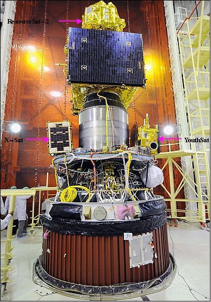
24 XSAT XSAT (experimental SATellite) Singapore s first earth observation satellite. Launched 20 April 2011, with two other satellites by India's Polar Satellite Launch Vehicle (PSLV-C16). Sun-synchronous near-polar low earth orbit Xsat is a developmental project undertaken by CREST (Centre For Research in Satellite Technologies) with participation from various schools in NTU, as well as partners such as CRISP (Centre for Remote Imaging, Sensing and Processing, NUS), and overseas collaborators (SaTReCi, ISRO and DLR).
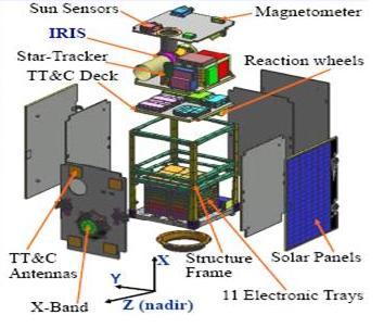
25 XSAT Space segment 105 kg micro-satellite Low earth orbit (817 km) Polar, sunsynchronous Payload multispectral 10m GSD optical camera (Red, Green, NIR) Swath 50km Launched on 20 th April 2011 on ISRO s PSLV C-16 Developed by Centre for Research in Satellite Technology (CREST)/ Satellite Research Centre (SaRC) at Nanyang Technological University (NTU), Singapore Ground segment S-band TT&C, X-band data downlink Data reception and processing system developed by CRISP at National University of Singapore (NUS) TT&C at NTU (CRISP as backup) Data downlink at CRISP
26 XSAT
")


27 XSAT S band Up/down link X band down link (50 Mbps) 6m S-band Antenna and CREST/NTU Image request 8.5m X band Antenna and CRISP/NUS (Also Backup MCS)

28 XSat Imaging Payload IRIS Pushbroom sensor array 3 spectral bands: Green ( nm) Red ( nm) NIR ( nm) Ground pixel width: 10 m Swath width: ~ 50 km Telescope aperture: 12.0 cm F-number: 4 XSat images are received and processed by CRISP s ground station


29 Green Red NIR Colour

30 Green Red NIR Colour

31 Geometically Rectified XSAT Image of Singapore 11 May 2011

32 CRISP XSAT Catalogue Browse

 : (-0.89,9.88,-8.")
33 XSAT Image Bangkok, Thailand CRISP - XSAT Catalogue Browse Image ID : XSAT Date/Time : _03:59:41 Sat Name : XSAT1 Shift by : 5 sec Latitude/Longitude Centre : 13 50'45" / '20" Top Left : 14 06'02" / '13" Top Right: 14 05'13" / '23" Bott Left : 13 35'59" / '20" Bott Right: 13 35'46" / '24" Look Elev : Look Az : Attitude (p,r,y) : (-0.89,9.88,-8.28) Remark : Thailand

 Cloud Avg : 0 Look Elev : 84.13 Look Az : 145.91 Attitude (p,r,y) : (3.08,6.50,10.")
34 CRISP - XSAT Catalogue Browse Image ID : XSAT XSAT Image Incheon, Korea Date/Time : _02:36:28 Sat Name : XSAT1 Latitude/Longitude Centre : 37 29'32" / '19" Top Left : 37 51'55" / '48" Top Right: 37 39'55" / '21" Bott Left : 37 19'28" / '37" Bott Right: 37 06'49" / '32 Cloud Cover: (0,0,0,0) Cloud Avg : 0 Look Elev : Look Az : Attitude (p,r,y) : (3.08,6.50,10.45) Remark : South_Korea_Incheon

35 XSAT Image Incheon,


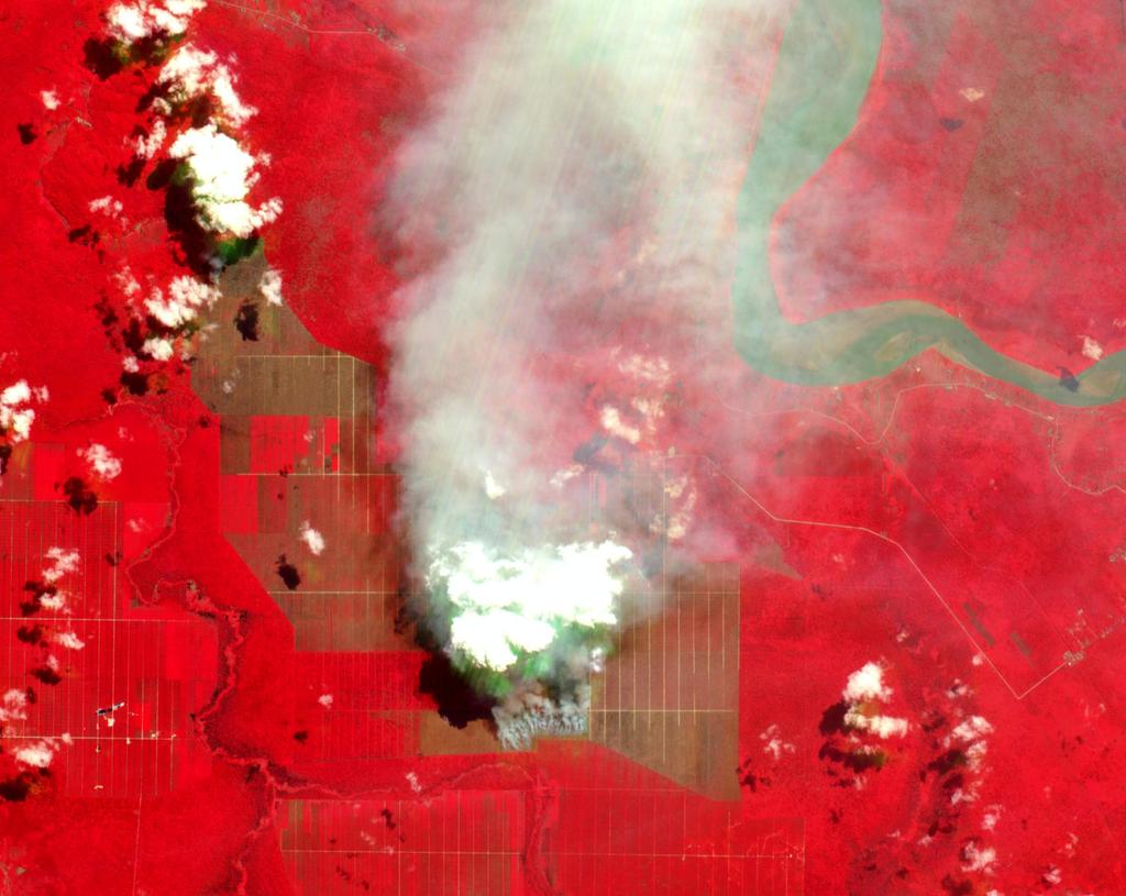
36 XSAT Image, Sumatra 28 Aug 2011 XSAT images are used in addition to SPOT images for CRISP s regional fire monitoring operation

37 Sumatra Forest Fire 28 Aug 2011
")
38 XSAT ( ) SPOT ( )


39 CRISP - XSAT Catalogue Browse Image ID : XSAT Vegetation Fires Sarawak :10:17 XSAT
40


41 XSAT image of 2011 Thailand Flood Flood Waters Flood Waters 26 Oct 2011


42 XSAT Image, Bangkok Area Don Muang Airport Flood Waters Bangkok Suvarnabhumi Airport 26 Oct 2011

43 Don Muang Airport Flood Waters 26 Oct 2011
 XSAT")
44 Comparison with pre-disaster satellite image Area: 24km by 36km SPOT ( ) XSAT ( )
45 Thank you
Futrajaya, Malaysia JULY 12, Jeong Heon SONG. Korea Aerospace Research Institution
 J P T M 2 0 1 1 Futrajaya, Malaysia JULY 12, 2011 Jeong Heon SONG Korea Aerospace Research Institution Outline Contribution of KARI Sentinel Asia / Data Provider Node International Charter KARI Space Activities
NON-PHOTOGRAPHIC SYSTEMS: Multispectral Scanners Medium and coarse resolution sensor comparisons: Landsat, SPOT, AVHRR and MODIS
 NON-PHOTOGRAPHIC SYSTEMS: Multispectral Scanners Medium and coarse resolution sensor comparisons: Landsat, SPOT, AVHRR and MODIS CLASSIFICATION OF NONPHOTOGRAPHIC REMOTE SENSORS PASSIVE ACTIVE DIGITAL
Geospatial Vision and Policies Korean Industry View 26 November, 2014 SI Imaging Services
 Geospatial Vision and Policies Korean Industry View 26 November, 2014 SI Imaging Services Distribution Limitation, SI Imaging Services Proprietary Data : The data contained in this document, without the
Introduction to Remote Sensing Fundamentals of Satellite Remote Sensing. Mads Olander Rasmussen
 Introduction to Remote Sensing Fundamentals of Satellite Remote Sensing Mads Olander Rasmussen (mora@dhi-gras.com) 01. Introduction to Remote Sensing DHI What is remote sensing? the art, science, and technology
Lecture 6: Multispectral Earth Resource Satellites. The University at Albany Fall 2018 Geography and Planning
 Lecture 6: Multispectral Earth Resource Satellites The University at Albany Fall 2018 Geography and Planning Outline SPOT program and other moderate resolution systems High resolution satellite systems
Light penetration within a clear water body. E z = E 0 e -kz
 THE BLUE PLANET 1 2 Light penetration within a clear water body E z = E 0 e -kz 3 4 5 Pure Seawater Phytoplankton b w 10-2 m -1 b w 10-2 m -1 b w, Morel (1974) a w, Pope and Fry (1997) b chl,loisel and
9/12/2011. Training Course Remote Sensing Basic Theory & Image Processing Methods September 2011
 Training Course Remote Sensing Basic Theory & Image Processing Methods 19 23 September 2011 Popular Remote Sensing Sensors & their Selection Michiel Damen (September 2011) damen@itc.nl 1 Overview Low resolution
Copernicus Introduction Lisbon, Portugal 13 th & 14 th February 2014
 Copernicus Introduction Lisbon, Portugal 13 th & 14 th February 2014 Contents Introduction GMES Copernicus Six thematic areas Infrastructure Space data An introduction to Remote Sensing In-situ data Applications
On the use of water color missions for lakes in 2021
 Lakes and Climate: The Role of Remote Sensing June 01-02, 2017 On the use of water color missions for lakes in 2021 Cédric G. Fichot Department of Earth and Environment 1 Overview 1. Past and still-ongoing
Light penetration within a clear water body. E z = E 0 e -kz
 THE BLUE PLANET 1 2 Light penetration within a clear water body E z = E 0 e -kz 3 4 5 6 Pure Seawater Phytoplankton b w 10-2 m -1 b w 10-2 m -1 b w, Morel (1974) a w, Pope and Fry (1997) b chl,loisel and
Data Sharing Issues in SE Asia
 Data Sharing Issues in SE Asia Kandasri Limpakom User Service and Business Development Office About GISTDA THEOS & Its Applications GISTDA s Data Sharing Geo-Informatics and Space Technology Development
Sensor resolutions from space: the tension between temporal, spectral, spatial and swath. David Bruce UniSA and ISU
 Sensor resolutions from space: the tension between temporal, spectral, spatial and swath David Bruce UniSA and ISU 1 Presentation aims 1. Briefly summarize the different types of satellite image resolutions
IKONOS High Resolution Multispectral Scanner Sensor Characteristics
 High Spatial Resolution and Hyperspectral Scanners IKONOS High Resolution Multispectral Scanner Sensor Characteristics Launch Date View Angle Orbit 24 September 1999 Vandenberg Air Force Base, California,
Remote Sensing Platforms
 Types of Platforms Lighter-than-air Remote Sensing Platforms Free floating balloons Restricted by atmospheric conditions Used to acquire meteorological/atmospheric data Blimps/dirigibles Major role - news
Introduction to KOMPSAT
 Introduction to KOMPSAT September, 2016 1 CONTENTS 01 Introduction of SIIS 02 KOMPSAT Constellation 03 New : KOMPSAT-3 50 cm 04 New : KOMPSAT-3A 2 KOMPSAT Constellation KOMPSAT series National space program
The studies began when the Tiros satellites (1960) provided man s first synoptic view of the Earth s weather systems.
 provided man s first synoptic view of the Earth s weather systems.") Remote sensing of the Earth from orbital altitudes was recognized in the mid-1960 s as a potential technique for obtaining information important for the effective use and conservation of natural resources.
Remote sensing of the Earth from orbital altitudes was recognized in the mid-1960 s as a potential technique for obtaining information important for the effective use and conservation of natural resources.
India recently successfully launched its PSLV-C16 rocked that carried into orbit the latest remote
 India recently successfully launched its PSLV-C16 rocked that carried into orbit the latest remote sensing satellite REsourcesat-2 that would study and help manage natural resources along with two Nano
Remote Sensing Platforms
 Remote Sensing Platforms Remote Sensing Platforms - Introduction Allow observer and/or sensor to be above the target/phenomena of interest Two primary categories Aircraft Spacecraft Each type offers different
Recent developments in Deep Blue satellite aerosol data products from NASA GSFC
 Recent developments in Deep Blue satellite aerosol data products from NASA GSFC Andrew M. Sayer, N. Christina Hsu (PI), Corey Bettenhausen, Myeong-Jae Jeong Climate & Radiation Laboratory, NASA Goddard
From Proba-V to Proba-MVA
 From Proba-V to Proba-MVA Fabrizio Niro ESA Sensor Performances Products and Algorithm (SPPA) ESA UNCLASSIFIED - For Official Use Proba-V extension in the Copernicus era Proba-V was designed with the main
Introduction. Satellite Research Centre (SaRC)
") SATELLITE RESEARCH CENTRE - SaRC Introduction The of NTU strives to be a centre of excellence in satellite research and training of students in innovative space missions. Its first milestone satellite
SATELLITE RESEARCH CENTRE - SaRC Introduction The of NTU strives to be a centre of excellence in satellite research and training of students in innovative space missions. Its first milestone satellite
Synthetic Aperture Radar for Rapid Flood Extent Mapping
 National Aeronautics and Space Administration ARSET Applied Remote Sensing Training http://arset.gsfc.nasa.gov @NASAARSET Synthetic Aperture Radar for Rapid Flood Extent Mapping Sang-Ho Yun ARIA Team Jet
Monitoring Natural Disasters with Small Satellites Smart Satellite Based Geospatial System for Environmental Protection
 Monitoring Natural Disasters with Small Satellites Smart Satellite Based Geospatial System for Environmental Protection Krištof Oštir, Space-SI, Slovenia Contents Natural and technological disasters Current
Passive Microwave Sensors LIDAR Remote Sensing Laser Altimetry. 28 April 2003
 Passive Microwave Sensors LIDAR Remote Sensing Laser Altimetry 28 April 2003 Outline Passive Microwave Radiometry Rayleigh-Jeans approximation Brightness temperature Emissivity and dielectric constant
Advanced Optical Satellite (ALOS-3) Overviews
 Overviews") K&C Science Team meeting #24 Tokyo, Japan, January 29-31, 2018 Advanced Optical Satellite (ALOS-3) Overviews January 30, 2018 Takeo Tadono 1, Hidenori Watarai 1, Ayano Oka 1, Yousei Mizukami 1, Junichi
K&C Science Team meeting #24 Tokyo, Japan, January 29-31, 2018 Advanced Optical Satellite (ALOS-3) Overviews January 30, 2018 Takeo Tadono 1, Hidenori Watarai 1, Ayano Oka 1, Yousei Mizukami 1, Junichi
SEN3APP Stakeholder Workshop, Helsinki Yrjö Rauste/VTT Kaj Andersson/VTT Eija Parmes/VTT
 Optical Products from Sentinel-2 and Suomi- NPP/VIIRS SEN3APP Stakeholder Workshop, Helsinki 19.11.2015 Yrjö Rauste/VTT Kaj Andersson/VTT Eija Parmes/VTT Structure of Presentation High-resolution data
GMES DA COPERNICUS
 2014 Airbus Defence and Space All rights reserved. The reproduction, distribution and utilization of this document as well as the communication of its contents to others without express authorization is
Remote Sensing 1 Principles of visible and radar remote sensing & sensors
 Remote Sensing 1 Principles of visible and radar remote sensing & sensors Nick Barrand School of Geography, Earth & Environmental Sciences University of Birmingham, UK Field glaciologist collecting data
National SPace Organization
 National SPace Organization A center of innovation and excellence for space technology Bo Chen National Space Organization Presented at JPTM 2014, Sentinel Asia Yangon, Myanmar, 11/19-21 NARLabs-NSPO About
RADAR (RAdio Detection And Ranging)
") RADAR (RAdio Detection And Ranging) CLASSIFICATION OF NONPHOTOGRAPHIC REMOTE SENSORS PASSIVE ACTIVE DIGITAL CAMERA THERMAL (e.g. TIMS) VIDEO CAMERA MULTI- SPECTRAL SCANNERS VISIBLE & NIR MICROWAVE Real
RADAR (RAdio Detection And Ranging) CLASSIFICATION OF NONPHOTOGRAPHIC REMOTE SENSORS PASSIVE ACTIVE DIGITAL CAMERA THERMAL (e.g. TIMS) VIDEO CAMERA MULTI- SPECTRAL SCANNERS VISIBLE & NIR MICROWAVE Real
The Current Status and Brief Results of Engineering Model for PALSAR-2 onboard ALOS-2 and Science Project
 The Current Status and Brief Results of Engineering Model for PALSAR-2 onboard ALOS-2 and Science Project + The 16 th KC meeting Japan Aerospace Exploration Agency Masanobu Shimada, Yukihiro KANKAKU The
REMOTE SENSING INTERPRETATION
 REMOTE SENSING INTERPRETATION Jan Clevers Centre for Geo-Information - WU Remote Sensing --> RS Sensor at a distance EARTH OBSERVATION EM energy Earth RS is a tool; one of the sources of information! 1
Geoinformatics. S S Jadhav Department of Geography M J College, Jalgaon Mail: Cell:
 Geoinformatics S S Jadhav Department of Geography M J College, Jalgaon Mail: sahadeoj@gmail.com Cell: 9763267396 1 Satellite Remote Sensing: What is Remote Sensing? "Remote sensing is the science (and
of the Small Satellite Mission Systematic Image Processing Eckehard Lorenz, DLR Berlin Ilmenau, Klaus Briess, TU Berlin 49th IWK
 Ilmenau, 27.-30.09. 2004 49th IWK Eckehard Lorenz, DLR Berlin Klaus Briess, TU Berlin Astro- und Feinwerktechnik Adlershof GmbH Systematic Image Processing of the Small Satellite Mission BIRD Optical Information
3/31/03. ESM 266: Introduction 1. Observations from space. Remote Sensing: The Major Source for Large-Scale Environmental Information
 Remote Sensing: The Major Source for Large-Scale Environmental Information Jeff Dozier Observations from space Sun-synchronous polar orbits Global coverage, fixed crossing, repeat sampling Typical altitude
OVERVIEW OF KOMPSAT-3A CALIBRATION AND VALIDATION
 OVERVIEW OF KOMPSAT-3A CALIBRATION AND VALIDATION DooChun Seo 1, GiByeong Hong 1, ChungGil Jin 1, DaeSoon Park 1, SukWon Ji 1 and DongHan Lee 1 1 KARI(Korea Aerospace Space Institute), 45, Eoeun-dong,
Microwave remote sensing. Rudi Gens Alaska Satellite Facility Remote Sensing Support Center
 Microwave remote sensing Alaska Satellite Facility Remote Sensing Support Center 1 Remote Sensing Fundamental The entire range of EM radiation constitute the EM Spectrum SAR sensors sense electromagnetic
MERIS instrument. Muriel Simon, Serco c/o ESA
 MERIS instrument Muriel Simon, Serco c/o ESA Workshop on Sustainable Development in Mountain Areas of Andean Countries Mendoza, Argentina, 26-30 November 2007 ENVISAT MISSION 2 Mission Chlorophyll case
Satellite and GPS technology
 Satellite and GPS technology Maryna Strydom (GIS Tg SA) Tel: (011) 441 6163 mstrydom@srk.co.za Overview General How Earth Observation Satellites work Uses of different EOS outputs How GPS work Types of
An Introduction to Geomatics. Prepared by: Dr. Maher A. El-Hallaq خاص بطلبة مساق مقدمة في علم. Associate Professor of Surveying IUG
 An Introduction to Geomatics خاص بطلبة مساق مقدمة في علم الجيوماتكس Prepared by: Dr. Maher A. El-Hallaq Associate Professor of Surveying IUG 1 Airborne Imagery Dr. Maher A. El-Hallaq Associate Professor
Final Examination Introduction to Remote Sensing. Time: 1.5 hrs Max. Marks: 50. Section-I (50 x 1 = 50 Marks)
") Final Examination Introduction to Remote Sensing Time: 1.5 hrs Max. Marks: 50 Note: Attempt all questions. Section-I (50 x 1 = 50 Marks) 1... is the technology of acquiring information about the Earth's
Final Examination Introduction to Remote Sensing Time: 1.5 hrs Max. Marks: 50 Note: Attempt all questions. Section-I (50 x 1 = 50 Marks) 1... is the technology of acquiring information about the Earth's
EnMAP Environmental Mapping and Analysis Program
 EnMAP Environmental Mapping and Analysis Program www.enmap.org Mathias Schneider Mission Objectives Regular provision of high-quality calibrated hyperspectral data Precise measurement of ecosystem parameters
Table Satellites used for observations by members of the Disaster Charter and others (except Daichi)
") 2.1.4 Cooperation with from overseas institutions JAXA asked Sentinel Asia and, on behalf of the Cabinet Office, the Disaster Charter to carry out emergency observations immediately after the earthquake
2.1.4 Cooperation with from overseas institutions JAXA asked Sentinel Asia and, on behalf of the Cabinet Office, the Disaster Charter to carry out emergency observations immediately after the earthquake
Remote Sensing Information System for Disaster Management
 Remote Sensing Information System for Disaster Management KWOH Leong Keong, LIEW Soo Chin, CHIA Aik Song, John LOW* National University of Singapore email: scliew@nus.edu.sg (*Currently at Meteorological
Korea s First Satellite for Satellite Laser Ranging
 1 Korea s First Satellite for Satellite Laser Ranging 1 Jun Ho Lee 1, S. B. Kim 1, K.H. Kim 1, S. H. Lee 1, Y. J. Im 1, Y. Fumin 2, C. Wanzhen 2 1 Korea Advanced Institute of Science and Technology, South
Monitoring the Earth Surface from space
 Monitoring the Earth Surface from space Picture of the surface from optical Imagery, i.e. obtained by telescopes or cameras operating in visual bandwith. Shape of the surface from radar imagery Surface
CHAPTER 7: Multispectral Remote Sensing
 CHAPTER 7: Multispectral Remote Sensing REFERENCE: Remote Sensing of the Environment John R. Jensen (2007) Second Edition Pearson Prentice Hall Overview of How Digital Remotely Sensed Data are Transformed
Satellite Imagery Characteristics, Uses and Delivery to GIS Systems. Wayne Middleton April 2014
 Satellite Imagery Characteristics, Uses and Delivery to GIS Systems Wayne Middleton April 2014 About Geoimage Founded in Brisbane 1988 Leading Independent company Specialists in satellite imagery and geospatial
PALSAR SCANSAR SCANSAR Interferometry
 PALSAR SCANSAR SCANSAR Interferometry Masanobu Shimada Japan Aerospace Exploration Agency Earth Observation Research Center ALOS PI symposium, Greece Nov. 6 2008 1 Introduction L-band PALSAR strip mode
Landgate Firewatch Update
 Landgate Adrian Allen Satellite Remote Sensing Services Landgate Leeuwin Centre for Earth Sensing Technologies Government of Western Australia Presentation Overview Firewatch Project New web services and
RADARSAT-2 Program Update Daniel De Lisle Canadian Space Agency
 RADARSAT-2 Program Update Daniel De Lisle Canadian Space Agency Presentation outline RADARSAT-1 Update RADARSAT-2 Mission description Mission Objectives System Characteristics Data Commercialization/Allocation
US Commercial Imaging Satellites
 US Commercial Imaging Satellites In the early 1990s, Russia began selling 2-meter resolution product from its archives of collected spy satellite imagery. Some of this product was down-sampled to provide
PEGASUS : a future tool for providing near real-time high resolution data for disaster management. Lewyckyj Nicolas
 PEGASUS : a future tool for providing near real-time high resolution data for disaster management Lewyckyj Nicolas nicolas.lewyckyj@vito.be http://www.pegasus4europe.com Overview Vito in a nutshell GI
Big picture with KOMPSAT KOMPSAT-3A / KOMPSAT-3 / KOMPSAT-5 / KOMPSAT-2
 Big picture with KOMPSAT KOMPSAT-3A / KOMPSAT-3 / KOMPSAT-5 / KOMPSAT-2 Big picture with KOMPSAT Introduction SI Imaging Services (SIIS) is the exclusive worldwide marketing and sales representative of
Maximize Utilization of the performance of EOSs and strengthen. The First Steering Committee Secretariat JAXA
 Maximize Utilization of the performance of EOSs and strengthen cooperation among DPN/DAN The First Steering Committee Secretariat JAXA ALOS 2 observation is strong tool for disaster monitoring Wide area/range
International Charter Space and Major Disasters
 International Charter Space and Major Disasters Sentinel Asia Joint Project Team Meeting July 7, 2010 Brenda Jones U.S. Geological Survey Charter Executive Secretariat Purpose An International agreement
EPS Bridge Low-Cost Satellite
 EPS Bridge Low-Cost Satellite Results of a Concept Study being performed for Dr. Hendrik Lübberstedt OHB-System AG OpSE Workshop Walberberg 8th November 2005 EPS Bridge Key System Requirements Minimum
Int n r t o r d o u d c u ti t on o n to t o Remote Sensing
 Introduction to Remote Sensing Definition of Remote Sensing Remote sensing refers to the activities of recording/observing/perceiving(sensing)objects or events at far away (remote) places. In remote sensing,
746A27 Remote Sensing and GIS. Multi spectral, thermal and hyper spectral sensing and usage
 746A27 Remote Sensing and GIS Lecture 3 Multi spectral, thermal and hyper spectral sensing and usage Chandan Roy Guest Lecturer Department of Computer and Information Science Linköping University Multi
The Nemo Bus: A Third Generation Nanosatellite Bus for Earth Monitoring and Observation
 The Nemo Bus: A Third Generation Nanosatellite Bus for Earth Monitoring and Observation FREDDY M. PRANAJAYA Manager, Advanced Systems Group S P A C E F L I G H T L A B O R A T O R Y University of Toronto
(Refer Slide Time: 1:20)
") Introduction to Remote Sensing Dr. Arun K Saraf Department of Earth Sciences Indian Institute of Technology Roorkee Lecture 02 Development of Remote Sensing Technology & Advantages Hello! This is second
Introduction to Remote Sensing Dr. Arun K Saraf Department of Earth Sciences Indian Institute of Technology Roorkee Lecture 02 Development of Remote Sensing Technology & Advantages Hello! This is second
ERS/ENVISAT ASAR Data Products and Services
 ERS/ENVISAT ASAR Data Products and Services Andrea Celentano Business Manager celentan@eurimage.com What is Eurimage? Founded in 1989 Current shareholders: Since 1989 Commercial Partner of the European
Affordable space based radar for homeland security
 Changing the economics of space Affordable space based radar for homeland security Adam Baker Brent Abbott Phil Whittaker Rachel Bird Luis Gomes Summary Why Radar? However: Radar data is expensive Users
1. INTRODUCTION. GOCI : Geostationary Ocean Color Imager
 1. INTRODUCTION The Korea Ocean Research and Development Institute (KORDI) releases an announcement of opportunity (AO) to carry out scientific research for the utilization of GOCI data. GOCI is the world
School of Rural and Surveying Engineering National Technical University of Athens
 Laboratory of Photogrammetry National Technical University of Athens Combined use of spaceborne optical and SAR data Incompatible data sources or a useful procedure? Charalabos Ioannidis, Dimitra Vassilaki
An Introduction to Remote Sensing & GIS. Introduction
 An Introduction to Remote Sensing & GIS Introduction Remote sensing is the measurement of object properties on Earth s surface using data acquired from aircraft and satellites. It attempts to measure something
The use of satellite images to forecast agricultural
 The use of satellite images to forecast agricultural Luxembourg, 12.03.2014 r. Tomasz Milewski NUTS for Poland: NUTS 1 macro-regions (grup of province, voivodships) (6), NUTS 2 - regions (province,
Overview of the Small Optical TrAnsponder (SOTA) Project
 Project") Overview of the Small Optical TrAnsponder (SOTA) Project Space Communications Laboratory Wireless Networks Research Center National Institute of Information and Communications Technology (NICT) Satellite
Overview of the Small Optical TrAnsponder (SOTA) Project Space Communications Laboratory Wireless Networks Research Center National Institute of Information and Communications Technology (NICT) Satellite
Detection and Monitoring Through Remote Sensing....The Need For A New Remote Sensing Platform
 WILDFIRES Detection and Monitoring Through Remote Sensing...The Need For A New Remote Sensing Platform Peter Kimball ASEN 5235 Atmospheric Remote Sensing 5/1/03 1. Abstract This paper investigates the
EARTH OBSERVATION WITH SMALL SATELLITES
 EARTH OBSERVATION WITH SMALL SATELLITES AT THE FUCHS-GRUPPE B. Penné, C. Tobehn, M. Kassebom, H. Lübberstedt OHB-System GmbH, Universitätsallee 27-29, D-28359 Bremen, Germany www.fuchs-gruppe.com ABSTRACT
The 1st AOSWA Workshop Chiang Mai, 22-24/2/2012
 The 1st AOSWA Workshop Chiang Mai, 22-24/2/2012 SPACE TECHNOLOGY DEVELOPMENT & APPLICATIONS FOR CLIMATE CHANGE MITIGATION IN VIETNAM Doan Minh Chung Space Technology Institute (STI) Vietnam Academy of
Workshop on Practical Applications of MODIS Data in Australia
 Workshop on Practical Applications of MODIS Data in Australia Leeuwin Centre, Floreat WA November 26-29, 2002 Liam Gumley Space Science and Engineering Center University of Wisconsin-Madison Introduction
Sources of Geographic Information
 Sources of Geographic Information Data properties: Spatial data, i.e. data that are associated with geographic locations Data format: digital (analog data for traditional paper maps) Data Inputs: sampled
Earth s Gravitational Pull
 Satellite & Sensors Space Countries Earth s Gravitational Pull The Earth's gravity pulls everything toward the Earth. In order to orbit the Earth, the velocity of a body must be great enough to overcome
John P. Stevens HS: Remote Sensing Test
 Name(s): Date: Team name: John P. Stevens HS: Remote Sensing Test 1 Scoring: Part I - /18 Part II - /40 Part III - /16 Part IV - /14 Part V - /93 Total: /181 2 I. History (3 pts. each) 1. What is the name
GOCI Status and Cooperation with CoastColour Project
 GOCI Status and Cooperation with CoastColour Project Joo-Hyung RYU Contribution from : KOSC colleaques Nov. 17, 2010 World 1 st GOCI/COMS Launch Campaign Launch Date : June 27 2010 Launch Vehicle : Ariane-V
HEMERA Constellation of passive SAR-based micro-satellites for a Master/Slave configuration
 HEMERA Constellation of passive SAR-based micro-satellites for a Master/Slave HEMERA Team Members: Andrea Bellome, Giulia Broggi, Luca Collettini, Davide Di Ienno, Edoardo Fornari, Leandro Lucchese, Andrea
ENMAP RADIOMETRIC INFLIGHT CALIBRATION, POST-LAUNCH PRODUCT VALIDATION, AND INSTRUMENT CHARACTERIZATION ACTIVITIES
 ENMAP RADIOMETRIC INFLIGHT CALIBRATION, POST-LAUNCH PRODUCT VALIDATION, AND INSTRUMENT CHARACTERIZATION ACTIVITIES A. Hollstein1, C. Rogass1, K. Segl1, L. Guanter1, M. Bachmann2, T. Storch2, R. Müller2,
Automated Damage Analysis from Overhead Imagery
 Automated Damage Analysis from Overhead Imagery EVAN JONES ANDRE COLEMAN SHARI MATZNER Pacific Northwest National Laboratory 1 PNNL FY2015 at a Glance $955 million in R&D expenditures 4,400 scientists,
USGS Welcome. 38 th CEOS Working Group on Calibration and Validation Plenary (WGCV-38)
") Landsat 5 USGS Welcome Prepared for 38 th CEOS Working Group on Calibration and Validation Plenary (WGCV-38) Presenter Tom Cecere International Liaison USGS Land Remote Sensing Program Elephant Butte Reservoir
Landsat 5 USGS Welcome Prepared for 38 th CEOS Working Group on Calibration and Validation Plenary (WGCV-38) Presenter Tom Cecere International Liaison USGS Land Remote Sensing Program Elephant Butte Reservoir
Introduction to Remote Sensing
 Introduction to Remote Sensing Spatial, spectral, temporal resolutions Image display alternatives Vegetation Indices Image classifications Image change detections Accuracy assessment Satellites & Air-Photos
Remote Sensing (RS) ENY-C2005 Geoinformation in Environmental Modelling Miina Rautiainen
 ENY-C2005 Geoinformation in Environmental Modelling Miina Rautiainen") Remote Sensing (RS) ENY-C2005 Geoinformation in Environmental Modelling 25.1.2017 12.1.2015: Wildfires in central Chile Miina Rautiainen (miina.a.rautiainen@aalto.fi) Digital globe "Remote Sensing means
Remote Sensing (RS) ENY-C2005 Geoinformation in Environmental Modelling 25.1.2017 12.1.2015: Wildfires in central Chile Miina Rautiainen (miina.a.rautiainen@aalto.fi) Digital globe "Remote Sensing means
New capabilities in Earth Observation for agriculture
 New capabilities in Earth Observation for agriculture Prof. Katarzyna Dabrowska-Zielinska Head of Remote Sensing Department Institute of Geodesy and Cartography Modzelewskiego 27 Street 02-679 Warsaw Poland
Introduction of Satellite Remote Sensing
 Introduction of Satellite Remote Sensing Spatial Resolution (Pixel size) Spectral Resolution (Bands) Resolutions of Remote Sensing 1. Spatial (what area and how detailed) 2. Spectral (what colors bands)
The world s most advanced constellation
 The DigitalGlobe Constellation The world s most advanced constellation of very high-resolution satellites The world s most advanced constellation The DigitalGlobe constellation of high-resolution satellites
Introduction to Radar
 National Aeronautics and Space Administration ARSET Applied Remote Sensing Training http://arset.gsfc.nasa.gov @NASAARSET Introduction to Radar Jul. 16, 2016 www.nasa.gov Objective The objective of this
remote sensing? What are the remote sensing principles behind these Definition
 Introduction to remote sensing: Content (1/2) Definition: photogrammetry and remote sensing (PRS) Radiation sources: solar radiation (passive optical RS) earth emission (passive microwave or thermal infrared
Coral Reef Remote Sensing
 Coral Reef Remote Sensing Spectral, Spatial, Temporal Scaling Phillip Dustan Sensor Spatial Resolutio n Number of Bands Useful Bands coverage cycle Operation Landsat 80m 2 2 18 1972-97 Thematic 30m 7
UNISCAN AND ALICE-SC GROUND STATIONS AND DEVELOPMENT OF THEIR NETWORKS
 UNISCAN AND ALICE-SC GROUND STATIONS AND DEVELOPMENT OF THEIR NETWORKS Gershenzon V.E., Gershenzon O.N. R&D Center ScanEx Commission WG IV/9 KEY WORDS: Uniscan, Alice-SC, Stations, Geo-Portals ABSTRACT:
Systematic Image Processing of the Small Satellite Mission BIRD
 Systematic Image Processing of the Small Satellite Mission BIRD Klaus Brieß 1, Eckehard Lorenz 2 1 Technische Universität Berlin, Institut für Luft und Raumfahrt, Marchstr.12, D-10587 Berlin 2 Deutsches
Japan's Greenhouse Gases Observation from Space
 1 Workshop on EC CEOS Priority on GHG Monitoring Japan's Greenhouse Gases Observation from Space 18 June, 2018@Ispra, Italy Masakatsu NAKAJIMA Japan Aerospace Exploration Agency Development and Operation
OVERVIEW OF THE ALOS SATELLITE SYSTEM
 OVERVIEW OF THE ALOS SATELLITE SYSTEM Presented to The Symposium for ALOS Data Application Users @Kogakuin University, Tokyo, Japan Mar. 27, 2001 Takashi Hamazaki Senior Engineer ALOS Project National
Module 3 Introduction to GIS. Lecture 8 GIS data acquisition
 Module 3 Introduction to GIS Lecture 8 GIS data acquisition GIS workflow Data acquisition (geospatial data input) GPS Remote sensing (satellites, UAV s) LiDAR Digitized maps Attribute Data Management Data
Remote Sensing for Resource Management
 Remote Sensing for Resource Management Ebenezer Nyadjro US Naval Research Lab/UNO RMU Summer Program (July 31-AUG 4, 2017) Motivation Polluted Pra River Motivation. 3 Motivation Polluted Pra River Motivation.
The Moderate Resolution Imaging Spectroradiometer (MODIS): Potential Applications for Climate Change and Modeling Studies
: Potential Applications for Climate Change and Modeling Studies") The Moderate Resolution Imaging Spectroradiometer (MODIS): Potential Applications for Climate Change and Modeling Studies Menas Kafatos, CEOSR, George Mason University Jim McManus, CEOSR, GMU and GES DISC
The Moderate Resolution Imaging Spectroradiometer (MODIS): Potential Applications for Climate Change and Modeling Studies Menas Kafatos, CEOSR, George Mason University Jim McManus, CEOSR, GMU and GES DISC
Operational Space-Based Imaging Systems
 Operational Space-Based Imaging Systems R E M O T E S E N S I N G & G E O S PAT I A L A N A LY S I S L A B D O I : 2 0 A U G U S T, 2 0 1 6 Earth Observation Systems U.S. or foreign government systems
Data Requirements Definition and Data Services Options for RAPP
 Data Requirements Definition and Data Services Options for RAPP Brian Killough CEOS Systems Engineering Office (SEO) 5 th GEOGLAM RAPP Workshop Frascati, Italy May 16-17, 2017 Requirements Update The observation
9/12/2011. Training Course Remote Sensing Basic Theory & Image Processing Methods September 2011
 Training Course Remote Sensing Basic Theory & Image Processing Methods 19 23 September 2011 Remote Sensing Platforms Michiel Damen (September 2011) damen@itc.nl 1 Overview Platforms & missions aerial surveys
Theme: ocean colour observations from the geostationary orbit
 A new IOCCG working group Theme: ocean colour observations from the geostationary orbit Today (Nov 1 st, 2008):1 st Working group meeting, with the following goals: - Members of the WG meet and know better
Radio Frequency Sensing from Space
 Radio Frequency Sensing from Space Edoardo Marelli ITU-R WP 7C Chairman ITU-R Seminar Manta (Ecuador) 20 September 2012 Why observing the Earth from space? Satellites orbiting around the Earth offer an