ERS/ENVISAT ASAR Data Products and Services
|
|
|
- Magdalen Rodgers
- 5 years ago
- Views:
Transcription

1 ERS/ENVISAT ASAR Data Products and Services Andrea Celentano Business Manager

2 What is Eurimage? Founded in 1989 Current shareholders: Since 1989 Commercial Partner of the European Space Agency (ESA) Premises: Rome Staff: approx. 30

3 Eurimage Application Provider Network N. America: 14 Europe: 90 Asia: 13 S. America: 8 Africa: 4 Oceania: 3
4 Data Distribution Rights QuickBird Exclusive distributor of QuickBird products in Europe (except Italy) and the Mediterranean Basin Landsat IRS World-wide exclusive commercial distributoror of Landsat data from ESA stations and part of the Business Partner Program with USGS Distribution rights in Europe for data from Euromap archive Radarsat ASTER Distribution rights for EU countries Distribution rights in Europe NOAA / AVHRR JERS Distribution rights of ESA archive Distribution rights of European archive Ad-hoc agreements with other missions/centers


5 ERS-ENVISAT Distribution Rights ESA appointed Distributing Entity for global commercialisation and distribution of ERS & ENVISAT data and services Partners and Roles Master Distributor: Eurimage Value Adders: ASI, Astrium Gmbh, DLR, Infoterra Ltd, QinetiQ, Telespazio Ground Stations: DLR, QinetiQ, Telespazio
6 EMMA Roles: Master Distributor Standard Products Distribution, Marketing and Promotion Contracts for direct reception and access to ERS/ENVISAT satellites Interface with ESA Setup & co-ordination of distribution network and Int. Ground Station contracts Access to Data Archives and Satellite Planning requests collection Catalogues: Einet and DESCW
7 ERS-1 & 2 The first orbiting SAR sensor. Initially for R&D, but has kickedoff many commercial and operational applications Largest SAR data archive, since 1991 Continuous and routine global acquisitions without the need of specific programming Advantages of SAR for any application Day/Night Imaging Cloud Cover Penetration Good Data Availability on a global scale
8 ERS-1 & 2 ERS ERS-2 April 1995 Satellite Orbital Characteristics Orbit Altitude Sun-synchronous 785 Km Inclination (98.52 ) Orbit per Day 14.3 Repeat Cycle Tandem Mode 35 days ERS-1 24hrs prior to ERS-2 Subsequent acquisitions since launch of ERS-2, 1995)
9 ERS SAR ERS-1 & 2 SAR Spatial resolution 25 m Area coverage 10,000 km 2 Frequency 5.3 GHz (C-band) Polarisation Linear-Vertical (VV) 14 Years Data Archive: ERS-1: 1.8 Mil. Frames ( ) ERS-2: 1.0 Mil. Frames (since 1995) Over 100,000 Products Generated amongst over 10,000 Users All-weather Data Availability ERS SAR Standard Products: RAW, SLC, PRI, GEC, GTC

10 ERS Ground Station Network

11 ENVISAT Mission

12 The ENVISAT Mission Launch Date: March 2002 Dimensions Launch configuration: length 10.5 m diameter 4.6 m In-Orbit configuration: 26m x 10m x 5m Mass Total satellite 8140 Kg Payload 2050 Kg Launch vehicle Ariane 5 Orbit: 800 km as ERS sun-synchronous 10:00, i.e. 30 min. before ERS-2 All sensors performing well

13 ENVISAT Improved Characteristics Provision of long-term data sets; continuity with ERS data characteristics Two Solid State Recorders (70 Gbit of data each) for on-board recording when outside of ESA station mask Ability to transmit to the ARTEMIS relay-satellite when ENVISAT is out of sight of any ESA ground station Improved sensor characteristics ASAR

14 ENVISAT Ground Segment
 PDAS (Matera) PDHS-K")


15 Kiruna-Artemis scenario ARTEMIS ENVISAT PDHS-E (ESRIN) PDAS (Matera) PDHS-K (Kiruna) DDS PACs 4/5 orbits are received in Kiruna 8 orbits in ESRIN (6 via Artemis) Matera receives ASAR HR and MERIS FR in direct visibility, data sent to ESRIN within a week

16 ENVISAT Instruments and Products ASAR Advanced Synthetic Aperture Radar
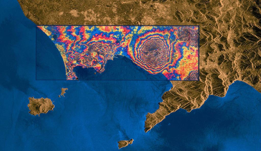
17 How ASAR works ASAR has five mutually exclusive modes of operation: Image mode Alternate Polarisation Wide Swath Wave Global Monitoring Image Mode, 30 m resolution, similar to ERS SAR. 7 possible mutual exclusive swaths 2 possible mutual exclusive polarisation (VV or HH) Alternate Pol. Mode, 30 m resolution 7 possible mutual exclusive swaths 3 possible mutual exclusive polarisation (HH/VV, HH/HV or VV/VH) Wide Swath Mode, 150 m resolution 1 unique swath (405 km) 2 possible mutual exclusive polarisation (VV or HH)

18 ENVISAT ASAR Operation Modes ASAR has 39 mutually exclusive modes of Acquisitions Global Monitoring VV or HH 1000m resolution 405 km swath width Wide Swath VV or HH 150m resolution 405 km swath width SLC, ES image format Image VV or HH < 30m resolution up to 100 km swath RAW, SLC, PRI, GEC Alternating Polarisation VV/HH or VV/VH or HH/HV 30m resolution up to 100 km swath RAW, SLC, PRI, GEC
19 Applications

20 The Oil Spill is analyzed and measured by a dedicated software. Morphological and Physical parameters are computed. Multivariate analysis and neural network techniques help the operator in the analysis of the object.

21 Oil Spill Report is sent by FAX to Coast Guards Contains all operative information for locate and define the pollution.


22 Ship Detection and Ship-Wake analysis An automatic algorithm detects ships visible in the SAR image. Ships responsible of the pollution are indicated.
 Deep water exploration outside of station mask with SSR and")
23 Off-Shore Exploration ENVISAT Improvements Greater coverage (Wide Swath and image Mode VV) Deep water exploration outside of station mask with SSR and Artemis


24 German Flooding 2002 Image Mode Image Mode, IS4, HH, 19 August, 22:53

25 Subsidence Monitoring


26 Monitoring Over Time Forward in time from May 1992 to September 2000

27 Lineaments and feature Mapping

28 Optical data : mapping of visible lineaments.

29 Radar allows the accurate mapping of all lineaments Accurate mapping of residual Identification of buried objects


30 Geological Structure Mapping Data Fusion with optical imagery
31 Commercial and Operational Overview
32 Eurimage Public Commercial Documentation
33 Products and Prices Archive Data
34 Future Acquisitions
35 Satellite Planning
36 Data Ordering
37 Data Production Parameters

38 DESCW Catalogue
39 Thank you Any Questions! More Information on Envisat:
The Sentinel-1 Constellation
 The Sentinel-1 Constellation Evert Attema, Sentinel-1 Mission & System Manager AGRISAR and EAGLE Campaigns Final Workshop 15-16 October 2007 ESA/ESTECNoordwijk, The Netherlands Sentinel-1 Programme Sentinel-1
Sentinel-1 Overview. Dr. Andrea Minchella
 Dr. Andrea Minchella 21-22/01/2016 ESA SNAP-Sentinel-1 Training Course Satellite Applications Catapult - Electron Building, Harwell, Oxfordshire Contents Sentinel-1 Mission Sentinel-1 SAR Modes Sentinel-1
Status of Sentinel-1 and acquisition plans for GFOI
 Status of Sentinel-1 and acquisition plans for GFOI Frank Martin Seifert, Pierre Potin, Johannes Roeder, ESA Earth Observation Programme 5 th Space Data Coordination, ESRIN, Frascati, 24 February 2014
KONGSBERG SATELLITE SERVICES 2017 Line Steinbakk, Director Programs. Himmel og hav - Ålesund 3. Oktober 2017
 KONGSBERG SATELLITE SERVICES 2017 Line Steinbakk, Director Programs Himmel og hav - Ålesund 3. Oktober 2017 KSAT HQ IN TROMSØ 69N Established in 1967 Kongsberg Satellite Services since 2002 World leading
Affordable space based radar for homeland security
 Changing the economics of space Affordable space based radar for homeland security Adam Baker Brent Abbott Phil Whittaker Rachel Bird Luis Gomes Summary Why Radar? However: Radar data is expensive Users
How to access EO data
 How to access EO data PAC USF USF PDHS LRAC USCF PDCC Europe s expanding EO Capability Continuity & Evolution Wind Scatterometer (Low rate) all weather; day and night SAR Antenna (C-Band, 5.3 GHz) image
Copernicus Introduction Lisbon, Portugal 13 th & 14 th February 2014
 Copernicus Introduction Lisbon, Portugal 13 th & 14 th February 2014 Contents Introduction GMES Copernicus Six thematic areas Infrastructure Space data An introduction to Remote Sensing In-situ data Applications
RADARSAT-2 Program Update Daniel De Lisle Canadian Space Agency
 RADARSAT-2 Program Update Daniel De Lisle Canadian Space Agency Presentation outline RADARSAT-1 Update RADARSAT-2 Mission description Mission Objectives System Characteristics Data Commercialization/Allocation
The Envisat Exploitation Policy
 r bulletin 106 june 2001 The Envisat Exploitation Policy G. Kohlhammer Earth-Observation Applications Department, ESA Directorate of Earth and Environment Monitoring from Space, ESRIN, Frascati, Italy
How to Access EO Data
 How to Access EO Data Andrea Minchella 29 June 2009, D1L1 ESA CAT-1 EO Principal Investigator ESA PIs and Projects 1-10 projects 11-20 projects 21-40 projects 41-60 projects 61-100 projects 101-200 projects
9/12/2011. Training Course Remote Sensing Basic Theory & Image Processing Methods September 2011
 Training Course Remote Sensing Basic Theory & Image Processing Methods 19 23 September 2011 Popular Remote Sensing Sensors & their Selection Michiel Damen (September 2011) damen@itc.nl 1 Overview Low resolution
Geospatial Vision and Policies Korean Industry View 26 November, 2014 SI Imaging Services
 Geospatial Vision and Policies Korean Industry View 26 November, 2014 SI Imaging Services Distribution Limitation, SI Imaging Services Proprietary Data : The data contained in this document, without the
Sentinel-1 System Overview
 Sentinel-1 System Overview Dirk Geudtner, Rámon Torres, Paul Snoeij, Malcolm Davidson European Space Agency, ESTEC Global Monitoring for Environment and Security (GMES) EU-led program aiming at providing
The Ability of a Small Satellite Constellation to Tip and Cue Other Commercial Assets
 Changing the economics of space The Ability of a Small Satellite Constellation to Tip and Cue Other Commercial Assets Becky Cudzilo - Surrey Satellite US, LLC K.C. Foley - GeoEye, Inc. Chandler Smith -
Co-ReSyF RA lecture: Vessel detection and oil spill detection
 This project has received funding from the European Union s Horizon 2020 Research and Innovation Programme under grant agreement no 687289 Co-ReSyF RA lecture: Vessel detection and oil spill detection
SAR missions for oceanography at the European Space Agency
 SAR missions for oceanography at the European Space Agency ERS-1, ERS-2, Envisat, Sentinel-1A, Sentinel-1B, ESA 3 rd Party Missions (ALOS) Prepared by ESA teams and ESA supporting companies ESA and SAR
Towards Sentinel-1 Soil Moisture Data Services: The Approach taken by the Earth Observation Data Centre for Water Resources Monitoring
 Towards Sentinel-1 Soil Moisture Data Services: The Approach taken by the Earth Observation Data Centre for Water Resources Monitoring Wolfgang Wagner wolfgang.wagner@geo.tuwien.ac.at Department of Geodesy
New capabilities in Earth Observation for agriculture
 New capabilities in Earth Observation for agriculture Prof. Katarzyna Dabrowska-Zielinska Head of Remote Sensing Department Institute of Geodesy and Cartography Modzelewskiego 27 Street 02-679 Warsaw Poland
Envisat and ERS missions: data and services
 FRINGE 2005 Workshop Envisat and ERS missions: and services Henri LAUR Envisat Mission Manager Our top objective: ease access to Earth Observation Common objective for all missions handled by ESA: Envisat,
Review. Guoqing Sun Department of Geography, University of Maryland ABrief
 Review Guoqing Sun Department of Geography, University of Maryland gsun@glue.umd.edu ABrief Introduction Scattering Mechanisms and Radar Image Characteristics Data Availability Example of Applications
COPERNICUS COLLABORATIVE GROUND SEGMENT TO SUPPORT MARITIME SITUATIONAL AWARENESS
 COPERNICUS COLLABORATIVE GROUND SEGMENT TO SUPPORT MARITIME SITUATIONAL AWARENESS D. Krause*, E. Schwarz, H. Damerow, German Aerospace Center (DLR), German Remote Sensing Data Center (DFD), Kalkhorstweg
European Space Agency and IPY
 European Space Agency and IPY ESA supports IPY 2007-2008 activities: First ESA step was a dedicated Announcement Opportunity (AO) for EO data provision in support IPY, released in 2006, with data provision
The Current Status and Brief Results of Engineering Model for PALSAR-2 onboard ALOS-2 and Science Project
 The Current Status and Brief Results of Engineering Model for PALSAR-2 onboard ALOS-2 and Science Project + The 16 th KC meeting Japan Aerospace Exploration Agency Masanobu Shimada, Yukihiro KANKAKU The
Sentinel-1 Calibration and Performance
 Sentinel-1 Calibration and Performance Paul Snoeij Evert Attema Björn Rommen Nicolas Floury Berthyl Duesmann Malcolm Davidson Ramon Torres European Space Agency Sentinel-1 Mission Objectives Component
Data acquisition and access for the Congo Basin
 MRV Joint Workshop 22-24 June 2010, Guadalajara, Jalisco Mexico Data acquisition and access for the Congo Basin Landing Mané 1, Michael Brady 2, Chris Justice 3 and Alice Altstatt 3 1) Satellite Observatory
GMES DA COPERNICUS
 2014 Airbus Defence and Space All rights reserved. The reproduction, distribution and utilization of this document as well as the communication of its contents to others without express authorization is
SAR Interferometry Capabilities of Canada's planned SAR Satellite Constellation
 SAR Interferometry Capabilities of Canada's planned SAR Satellite Constellation Dirk Geudtner, Guy Séguin,, Ralph Girard Canadian Space Agency RADARSAT Follow-on Program CSA is in the middle of a Phase
Satellite data for Maritime Operations. Andreas Hay Kaljord Project Manager Energy, Environment & Security
 Satellite data for Maritime Operations Andreas Hay Kaljord Project Manager Energy, Environment & Security Kongsberg Satellite Services (KSAT) World leading provider within our business area Supports 85
WHAT IS NEXT IN EARTH OBSERVATION. SkyMed Mission
 WHAT IS NEXT IN EARTH OBSERVATION COSMO-SkyMed SkyMed Mission Paolo Ammendola Italian Space Agency Florence, Sept. 19, 2001 ammendola@asi asi.it THE NEEDS Market studies indicate that the value of the
Introduction to Radar
 National Aeronautics and Space Administration ARSET Applied Remote Sensing Training http://arset.gsfc.nasa.gov @NASAARSET Introduction to Radar Jul. 16, 2016 www.nasa.gov Objective The objective of this
KOMPSAT Constellation. November 2012 Satrec Initiative
 KOMPSAT Constellation November 2012 Satrec Initiative KOMPSAT Constellation KOMPSAT National program Developed and operated by KARI (Korea Aerospace Research Institute) Dual use : Government & commercial
ASAR WIDE-SWATH SINGLE-LOOK COMPLEX PRODUCTS: PROCESSING AND EXPLOITATION POTENTIAL
 ASAR WIDE-SWATH SINGLE-LOOK COMPLEX PRODUCTS: PROCESSING AND EXPLOITATION POTENTIAL Ralph Cordey (1), Tim Pearson (2), Yves-Louis Desnos (3), Betlem Rosich-Tell (3) (1) European Space Agency, ESTEC, Keplerlaan
Imagery Archive Works
 USDA How Satellite the Imagery USDA s Archive Satellite Imagery Archive Works A. What is the USDA Satellite Imagery Archive? B. What are the benefits of participating in the USDA Archive? C. What types
Remote Sensing Analysis Framework for Maritime Surveillance Application
 Remote Sensing Analysis Framework for Maritime Surveillance Application Olaf Frauenberger, Egbert Schwarz, Sergey Voinov Maritime Security Lab Neustrelitz (DFD) Maritime Big Data Workshop, 9-11 May, La
UNISCAN AND ALICE-SC GROUND STATIONS AND DEVELOPMENT OF THEIR NETWORKS
 UNISCAN AND ALICE-SC GROUND STATIONS AND DEVELOPMENT OF THEIR NETWORKS Gershenzon V.E., Gershenzon O.N. R&D Center ScanEx Commission WG IV/9 KEY WORDS: Uniscan, Alice-SC, Stations, Geo-Portals ABSTRACT:
Towards Global Monitoring of Soil Moisture at 1 km Spatial Resolution using Sentinel-1: Initial Results
 Towards Global Monitoring of Soil Moisture at 1 km Spatial Resolution using Sentinel-1: Initial Results W. Wagner, V. Naeimi, B. Bauer-Marschallinger, S. Cao, A. Dostalova, C. Notarnicola, F. Greifeneder,
Prague - 29 June 2009 A. COLETTA COLETTA. COSMO-SkyMed Mission: COSMO-SkyMed Mission. Application and Data Access
 A. A. COLETTA COLETTA COSMO-SkyMed COSMO-SkyMed Mission Mission Manager Manager ITALIAN ITALIAN SPACE SPACE AGENCY AGENCY COSMO-SkyMed Mission: Application and Data Access The COSMO-SkyMed PROGRAMME The
Introduction to KOMPSAT
 Introduction to KOMPSAT September, 2016 1 CONTENTS 01 Introduction of SIIS 02 KOMPSAT Constellation 03 New : KOMPSAT-3 50 cm 04 New : KOMPSAT-3A 2 KOMPSAT Constellation KOMPSAT series National space program
EO Data Today and Application Fields. Denise Petala
 EO Data Today and Application Fields Denise Petala ! IGD GROUP AE "Infotop SA, Geomet Ltd., Dynatools Ltd. "Equipment and know how in many application fields, from surveying till EO data and RS. # Leica,
The ERS contribution to Oil Spill Monitoring - From R&D towards an operational service -
 The ERS contribution to Oil Spill Monitoring - From R&D towards an operational service - J.P. Pedersen, T.Bauna, L.G. Seljelv, L. Steinbakk, R.T.Enoksen Tromsø Satellite Station, N-9291 Tromsø, Norway
Satellite Imagery Characteristics, Uses and Delivery to GIS Systems. Wayne Middleton April 2014
 Satellite Imagery Characteristics, Uses and Delivery to GIS Systems Wayne Middleton April 2014 About Geoimage Founded in Brisbane 1988 Leading Independent company Specialists in satellite imagery and geospatial
KONGSBERG SATELLITE SERVICES Earth Observation for Maritime Operations Current Capabilities and Future Potential
 KONGSBERG SATELLITE SERVICES 2017 Earth Observation for Maritime Operations Current Capabilities and Future Potential Andreas Hay Kaljord Project Manager KSAT HQ IN TROMSØ - 69N WELCOME TO TROMSØ Established
Introduction to Remote Sensing Fundamentals of Satellite Remote Sensing. Mads Olander Rasmussen
 Introduction to Remote Sensing Fundamentals of Satellite Remote Sensing Mads Olander Rasmussen (mora@dhi-gras.com) 01. Introduction to Remote Sensing DHI What is remote sensing? the art, science, and technology
Big picture with KOMPSAT KOMPSAT-3A / KOMPSAT-3 / KOMPSAT-5 / KOMPSAT-2
 Big picture with KOMPSAT KOMPSAT-3A / KOMPSAT-3 / KOMPSAT-5 / KOMPSAT-2 Big picture with KOMPSAT Introduction SI Imaging Services (SIIS) is the exclusive worldwide marketing and sales representative of
The Earth Observation Programme at ESA
 The Earth Observation Programme at ESA 24-October-2007, International Ice Charting Working Group Meeting Simon.Jutz@esa.int Earth Observation Programmes Directorate European Space Agency EO missions handled
Cristina M. Surdu 1, Claude R. Duguay 2 and Diego Fernández Prieto 1
 Cristina M. Surdu 1, Claude R. Duguay 2 and Diego Fernández Prieto 1 1 European Space Agency, ESRIN, Italy 2 University of Waterloo, Ontario, Canada Objectives To document and analyze the response of High
KEY TECHNOLOGY DEVELOPMENT FOR THE ADVENACED LAND OBSERVING SATELLITE
 KEY TECHNOLOGY DEVELOPMENT FOR THE ADVENACED LAND OBSERVING SATELLITE Takashi HAMAZAKI, and Yuji OSAWA National Space Development Agency of Japan (NASDA) hamazaki.takashi@nasda.go.jp yuji.osawa@nasda.go.jp
FORMOSAT-5. - Launch Campaign-
 1 FORMOSAT-5 - Launch Campaign- FORMOSAT-5 Launch Campaign 2 FORMOSAT-5 Launch Campaign Launch Date: 2017.08.24 U.S. Pacific Time Activities 11:50-12:23 Launch Window 13:30-16:00 Reception 3 FORMOSAT-5
ACTIVE SENSORS RADAR
 ACTIVE SENSORS RADAR RADAR LiDAR: Light Detection And Ranging RADAR: RAdio Detection And Ranging SONAR: SOund Navigation And Ranging Used to image the ocean floor (produce bathymetic maps) and detect objects
Remote Sensing. Ch. 3 Microwaves (Part 1 of 2)
") Remote Sensing Ch. 3 Microwaves (Part 1 of 2) 3.1 Introduction 3.2 Radar Basics 3.3 Viewing Geometry and Spatial Resolution 3.4 Radar Image Distortions 3.1 Introduction Microwave (1cm to 1m in wavelength)
Remote Sensing Ch. 3 Microwaves (Part 1 of 2) 3.1 Introduction 3.2 Radar Basics 3.3 Viewing Geometry and Spatial Resolution 3.4 Radar Image Distortions 3.1 Introduction Microwave (1cm to 1m in wavelength)
XSAT Ground Segment at CRISP
 XSAT Ground Segment at CRISP LIEW Soo Chin Head of Research, CRISP http://www.crisp.nus.edu.sg 5 th JPTM for Sentinel Asia Step-2, 14-16 Nov 2012, Daejeon, Korea Centre for Remote Imaging, Sensing and
*For International Stewardship of the Maritime Environment and its Resources. Photo
 *For International Stewardship of the Maritime Environment and its Resources *For Maritime Safety *For Security Photo # Providing Environmental Monitoring* # Increasing Security* # Enabling Safety Efforts*
REMOTE SENSING FOR FLOOD HAZARD STUDIES.
 REMOTE SENSING FOR FLOOD HAZARD STUDIES. OPTICAL SENSORS. 1 DRS. NANETTE C. KINGMA 1 Optical Remote Sensing for flood hazard studies. 2 2 Floods & use of remote sensing. Floods often leaves its imprint
Satellite Technologies for Fisheries Monitoring, Control and Surveillance (MCS)
") JRC IPSC Maritime Affairs 1 Satellite Technologies for Fisheries Monitoring, Control and Surveillance (MCS) Juan Cicuendez, Marlene Alvarez JRC Info Day Madrid, 2 June 2010 IPSC - Institute for the Protection
JRC IPSC Maritime Affairs 1 Satellite Technologies for Fisheries Monitoring, Control and Surveillance (MCS) Juan Cicuendez, Marlene Alvarez JRC Info Day Madrid, 2 June 2010 IPSC - Institute for the Protection
SARscape for ENVI. A Complete SAR Analysis Solution
 SARscape for ENVI A Complete SAR Analysis Solution IDL and ENVI A Foundation for SARscape IDL The Data Analysis & Visualization Platform Data Access: IDL supports virtually every data format, type and
A CONCEPT FOR NATURAL GAS TRANSMISSION PIPELINE MONITORING BASED ON NEW HIGH-RESOLUTION REMOTE SENSING TECHNOLOGIES
 A CONCEPT FOR NATURAL GAS TRANSMISSION PIPELINE MONITORING BASED ON NEW HIGH-RESOLUTION REMOTE SENSING TECHNOLOGIES Werner Zirnig - Ruhrgas Aktiengesellschaft Dieter Hausamann - DLR German Aerospace Center
ASAR, MERIS and AATSR products
 ASAR, MERIS and AATSR products Francesco Sarti and Steffen Dransfeld ESA/ESRIN 25 February 2008 ENVISAT http://envisat.esa.int/ Launched in 2002. Sun-synchronous polar orbit (SSO): Nominal reference orbit
US Commercial Imaging Satellites
 US Commercial Imaging Satellites In the early 1990s, Russia began selling 2-meter resolution product from its archives of collected spy satellite imagery. Some of this product was down-sampled to provide
Microwave Remote Sensing (1)
") Microwave Remote Sensing (1) Microwave sensing encompasses both active and passive forms of remote sensing. The microwave portion of the spectrum covers the range from approximately 1cm to 1m in wavelength.
Microwave Remote Sensing (1) Microwave sensing encompasses both active and passive forms of remote sensing. The microwave portion of the spectrum covers the range from approximately 1cm to 1m in wavelength.
NovaSAR-S - Bringing Radar Capability to the Disaster Monitoring Constellation
 Changing the economics of space NovaSAR-S - Bringing Radar Capability to the Disaster Monitoring Constellation SSTL: Philip Davies, Phil Whittaker, Rachel Bird, Luis Gomes, Ben Stern, Prof Sir Martin Sweeting
Futrajaya, Malaysia JULY 12, Jeong Heon SONG. Korea Aerospace Research Institution
 J P T M 2 0 1 1 Futrajaya, Malaysia JULY 12, 2011 Jeong Heon SONG Korea Aerospace Research Institution Outline Contribution of KARI Sentinel Asia / Data Provider Node International Charter KARI Space Activities
The Role of RADARSAT-2 for Flood and Agriculture Monitoring
 The Role of RADARSAT-2 for Flood and Agriculture Monitoring Gordon Staples MDA Richmond, BC, CANADA gstaples@mda.ca RESTRICTION ON USE, PUBLICATION OR DISCLOSURE OF PROPRETIARY INFORMATION This document
ALOS and PALSAR. Masanobu Shimada
 ALOS and PALSAR Masanobu Shimada Earth Observation Research Center, National Space Development Agency of Japan, Harumi 1-8-10, Harumi island triton square office tower X 22, Chuo-Ku, Tokyo-To, Japan, 104-6023,
ASSESSMENT BY ESA OF GCOS CLIMATE MONITORING PRINCIPLES FOR GMES
 Prepared by ESA Agenda Item: III.5 Discussed in WG3 ASSESSMENT BY ESA OF GCOS CLIMATE MONITORING PRINCIPLES FOR GMES The ESA Sentinel missions are being designed for the GMES services, with special emphasis
ACTIVE MICROWAVE REMOTE SENSING OF LAND SURFACE HYDROLOGY
 Basics, methods & applications ACTIVE MICROWAVE REMOTE SENSING OF LAND SURFACE HYDROLOGY Annett.Bartsch@polarresearch.at Active microwave remote sensing of land surface hydrology Landsurface hydrology:
Earth Watching: A Window on Special Events
 r bulletin 94 may 1998 Earth Watching: A Window on Special Events S. D Elia Earth Remote Sensing Exploitation Division, Directorate of Application Programmes, ESRIN, Frascati, Italy R. Biasutti EO Satellite
International Charter Space and Major Disasters
 International Charter Space and Major Disasters Sentinel Asia Joint Project Team Meeting July 7, 2010 Brenda Jones U.S. Geological Survey Charter Executive Secretariat Purpose An International agreement
A NEAR-REAL TIME OIL SLICK MONITORING DEMONSTRATOR FOR THE MEDITERRANEAN
 A NEAR-REAL TIME OIL SLICK MONITORING DEMONSTRATOR FOR THE MEDITERRANEAN Juerg LICHTENEGGER, Gianna CALABRESI, ESA/ESRIN, Frascati Italy Andrea PETROCCHI, Vitrociset, Rome, Italy Working Group IV/2 KEY
SAR Remote Sensing (Microwave Remote Sensing)
") iirs SAR Remote Sensing (Microwave Remote Sensing) Synthetic Aperture Radar Shashi Kumar shashi@iirs.gov.in Electromagnetic Radiation Electromagnetic radiation consists of an electrical field(e) which
iirs SAR Remote Sensing (Microwave Remote Sensing) Synthetic Aperture Radar Shashi Kumar shashi@iirs.gov.in Electromagnetic Radiation Electromagnetic radiation consists of an electrical field(e) which
An Introduction to Geomatics. Prepared by: Dr. Maher A. El-Hallaq خاص بطلبة مساق مقدمة في علم. Associate Professor of Surveying IUG
 An Introduction to Geomatics خاص بطلبة مساق مقدمة في علم الجيوماتكس Prepared by: Dr. Maher A. El-Hallaq Associate Professor of Surveying IUG 1 Airborne Imagery Dr. Maher A. El-Hallaq Associate Professor
Observing Dry-Fallen Intertidal Flats in the German Bight Using ALOS PALSAR Together With Other Remote Sensing Sensors
 Observing Dry-Fallen Intertidal Flats in the German Bight Using ALOS PALSAR Together With Other Remote Sensing Sensors Martin Gade, Institut für Meereskunde & Kerstin Stelzer Brockmann Consult Outline
Polarisation Capabilities and Status of TerraSAR-X
 Polarisation Capabilities and Status of TerraSAR-X Irena Hajnsek, Josef Mittermayer, Stefan Buckreuss, Kostas Papathanassiou German Aerospace Center Microwaves and Radar Institute irena.hajnsek@dlr.de
RESERVOIR MONITORING USING RADAR SATELLITES
 RESERVOIR MONITORING USING RADAR SATELLITES Alain Arnaud, Johanna Granda, Geraint Cooksley ALTAMIRA INFORMATION S.L., Calle Córcega 381-387, E-08037 Barcelona, Spain. Key words: Reservoir monitoring, InSAR,
ASAR acquisition strategy for IPY -Update-
 ASAR acquisition strategy for IPY -Update- Jorge Del Rio Vera Henri Laur Presentation contents: 1. Background 2. ASAR Acquisition strategy update Tandem Campaign ICESat support campaign Wilkins Iceshelf
Maximize Utilization of the performance of EOSs and strengthen. The First Steering Committee Secretariat JAXA
 Maximize Utilization of the performance of EOSs and strengthen cooperation among DPN/DAN The First Steering Committee Secretariat JAXA ALOS 2 observation is strong tool for disaster monitoring Wide area/range
TerraSAR-X Image Product Guide
 [Texte] TerraSAR-X Image Product Guide Page 1 of 24 Ref.: OP00xxxxxxxxxx Commercial in Confidence 1 Introduction TerraSAR-X and TanDEM-X are commercial German Synthetic Aperture Radar (SAR) Earth observation
The Normal Baseline. Dick Gent Law of the Sea Division UK Hydrographic Office
 The Normal Baseline Dick Gent Law of the Sea Division UK Hydrographic Office 2 The normal baseline for measuring the breadth of the territorial sea is the low water line along the coast as marked on large
SARscape Modules for ENVI
 Visual Information Solutions SARscape Modules for ENVI Read, process, analyze, and output products from SAR data. ENVI. Easy to Use Tools. Proven Functionality. Fast Results. DEM, based on TerraSAR-X-1
9/12/2011. Training Course Remote Sensing Basic Theory & Image Processing Methods September 2011
 Training Course Remote Sensing Basic Theory & Image Processing Methods 19 23 September 2011 Remote Sensing Platforms Michiel Damen (September 2011) damen@itc.nl 1 Overview Platforms & missions aerial surveys
SAR Imagery: Airborne or Spaceborne? Presenter: M. Lorraine Tighe PhD
 SAR Imagery: Airborne or Spaceborne? Presenter: M. Lorraine Tighe PhD Introduction The geospatial community has seen a plethora of spaceborne SAR imagery systems where there are now extensive archives
SST radar in Cheia
 SST radar in Cheia 13.06.2018 Summary: About Space Alliance, Telespazio & RARTEL; Participation of RARTEL in ESA projects; Cheia antenna retrofit project 2 Telespazio in Romania: RARTEL SA RARTEL and the
7.7 TerraSAR-X & TanDEM-X
 7.7 TerraSAR-X & TanDEM-X Two Innovative Remote Sensing Stars for space-borne Earth Observation Vorlesung Wolfgang Keydel Microwaves and Radar Institute, German Aerospace Research Center (DLR), D-82230
Satellite and GPS technology
 Satellite and GPS technology Maryna Strydom (GIS Tg SA) Tel: (011) 441 6163 mstrydom@srk.co.za Overview General How Earth Observation Satellites work Uses of different EOS outputs How GPS work Types of
GMES Sentinel-1 Transponder Development
 GMES Sentinel-1 Transponder Development Paul Snoeij Evert Attema Björn Rommen Nicolas Floury Malcolm Davidson ESA/ESTEC, European Space Agency, Noordwijk, The Netherlands Outline 1. GMES Sentinel-1 overview
The Radar Ortho Suite is an add-on to Geomatica. It requires Geomatica Core or Geomatica Prime as a pre-requisite.
 Technical Specifications Radar Ortho Suite The Radar Ortho Suite includes rigorous and rational function models developed to compensate for distortions and produce orthorectified radar images. Distortions
NON-PHOTOGRAPHIC SYSTEMS: Multispectral Scanners Medium and coarse resolution sensor comparisons: Landsat, SPOT, AVHRR and MODIS
 NON-PHOTOGRAPHIC SYSTEMS: Multispectral Scanners Medium and coarse resolution sensor comparisons: Landsat, SPOT, AVHRR and MODIS CLASSIFICATION OF NONPHOTOGRAPHIC REMOTE SENSORS PASSIVE ACTIVE DIGITAL
Mission requirements and satellite overview
 Mission requirements and satellite overview E. BOUSSARIE 1 Dual concept Users need Defence needs Fulfil the Defence needs on confidentiality and security Civilian needs Fulfillment of the different needs
SPACE BASED RADIOLOCATION SYSTEMS - PRESENT STATE AND PERSPECTIVES FOR DEVELOPMENT
 SPACE BASED RADIOLOCATION SYSTEMS - PRESENT STATE AND PERSPECTIVES FOR DEVELOPMENT Petar Stoyanov, Venzislav Markov, Mihail Mihov, Georgi Kiprov Space Research Institute - BAS6, Moskovska St. P.O.Box 799,
Oil & Gas / EO Service Industry Workshop September 2010
 Oil & Gas / EO Service Industry Workshop 14-15 September 2010 Stephen Coulson, Philppe Bally, Gordon Campbell, Ben Koetz, Pierre-Philippe Mathieu, Ola Grabak, (ESA) Ana Belen Ruescas (Serco) Introduction
3/31/03. ESM 266: Introduction 1. Observations from space. Remote Sensing: The Major Source for Large-Scale Environmental Information
 Remote Sensing: The Major Source for Large-Scale Environmental Information Jeff Dozier Observations from space Sun-synchronous polar orbits Global coverage, fixed crossing, repeat sampling Typical altitude
TerraSAR-X and TanDEM-X: Revolution in Spaceborne Radar
 TerraSAR-X and TanDEM-X: Revolution in Spaceborne Radar Ralf Düring, Fifamè N. Koudogbo, and Marco Weber, Infoterra GmbH, 88039 Friedrichshafen, Germany INTRODUCTION While Earth Observation from space
Introduction to Galileo PRS
 Introduction to Galileo PRS Fabio Covello 20/09/2017 ESA UNCLASSIFIED - For Official Use Galileo mission figures The Galileo Space Segment: 30 satellites (full constellation) Walker 24/3/1 constellation
Synthetic aperture RADAR (SAR) principles/instruments October 31, 2018
 principles/instruments October 31, 2018") GEOL 1460/2461 Ramsey Introduction to Remote Sensing Fall, 2018 Synthetic aperture RADAR (SAR) principles/instruments October 31, 2018 I. Reminder: Upcoming Dates lab #2 reports due by the start of next
GEOL 1460/2461 Ramsey Introduction to Remote Sensing Fall, 2018 Synthetic aperture RADAR (SAR) principles/instruments October 31, 2018 I. Reminder: Upcoming Dates lab #2 reports due by the start of next
Synthetic Aperture Radar for Rapid Flood Extent Mapping
 National Aeronautics and Space Administration ARSET Applied Remote Sensing Training http://arset.gsfc.nasa.gov @NASAARSET Synthetic Aperture Radar for Rapid Flood Extent Mapping Sang-Ho Yun ARIA Team Jet
Warren Cartwright, Product Manager MDA Geospatial Services, Canada
 Advanced InSAR Techniques for Urban Infrastructure Monitoring Warren Cartwright, Product Manager MDA Geospatial Services, Canada www.mdacorporation.com RESTRICTION ON USE, PUBLICATION OR DISCLOSURE OF
Abstract. 1. Introduction
 Title: Satellite surveillance for maritime border monitoring Author: H. Greidanus Number: File: GMOSSBordMon1-2.doc Version: 1-2 Project: GMOSS Date: 25 Aug 2004 Distribution: Abstract Present day remote
Lecture 6: Multispectral Earth Resource Satellites. The University at Albany Fall 2018 Geography and Planning
 Lecture 6: Multispectral Earth Resource Satellites The University at Albany Fall 2018 Geography and Planning Outline SPOT program and other moderate resolution systems High resolution satellite systems
OVERVIEW OF KOMPSAT-3A CALIBRATION AND VALIDATION
 OVERVIEW OF KOMPSAT-3A CALIBRATION AND VALIDATION DooChun Seo 1, GiByeong Hong 1, ChungGil Jin 1, DaeSoon Park 1, SukWon Ji 1 and DongHan Lee 1 1 KARI(Korea Aerospace Space Institute), 45, Eoeun-dong,
Galileo. 7th ITFS, Rome, Italy, 3-5 November Dr. Stefan Bedrich. Kayser-Threde GmbH Wolfratshauser Str Munich
 Kayser-Threde GmbH Wolfratshauser Str. 48 81379 Munich spacetech@kayser-threde.com Galileo 7th ITFS, Rome, Italy, 3-5 November 2009 Dr. Stefan Bedrich w w w. k a y s e r - t h r e d e. c o m Outline Motivation
The studies began when the Tiros satellites (1960) provided man s first synoptic view of the Earth s weather systems.
 provided man s first synoptic view of the Earth s weather systems.") Remote sensing of the Earth from orbital altitudes was recognized in the mid-1960 s as a potential technique for obtaining information important for the effective use and conservation of natural resources.
Remote sensing of the Earth from orbital altitudes was recognized in the mid-1960 s as a potential technique for obtaining information important for the effective use and conservation of natural resources.