NovaSAR-S - Bringing Radar Capability to the Disaster Monitoring Constellation
|
|
|
- Audra Baldwin
- 5 years ago
- Views:
Transcription


1 Changing the economics of space NovaSAR-S - Bringing Radar Capability to the Disaster Monitoring Constellation SSTL: Philip Davies, Phil Whittaker, Rachel Bird, Luis Gomes, Ben Stern, Prof Sir Martin Sweeting Astrium: Martin Cohen, David Hall USU Small Satellite Conference, August 2012, Logan, Utah
2 Contents Approach The NovaSAR-S solution Baseline capability First mission USU Smallsat
3 Changing the economics of space Approach


4 Traditional Approach Typical SAR mission requirements All things to all men Serving all applications means all imaging parameters optimised Swath, resolution, sensitivity, ambiguity ratio, duty cycle, imaging throughput.. Performance focused development Antenna size and power consumption driven to extremes Typical SAR mission budget required! >1000kg, >?00M. TerraSAR-X 1230kg COSMO-SkyMed 1900kg Radarsat kg USU Smallsat


5 Applications focused approach Starting point: What useful performance can we get from a minimal cost solution that fits low cost launches? Low mission cost target (spacecraft+launch+groundsegment) Follow optical Disaster Monitoring Constellation model COTS technology where suitable Medium resolution (i.e. not 1m) and wide coverage Constellation possibilities attractive BUT single platform must stand on its own merits SSTL optical satellites kg USU Smallsat
6 Maritime Services Target Applications Ship detection and tracking Oil spill detection and monitoring Iceberg detection and tracking Ice edge Monitoring Tropical Forest Monitoring De-forestation monitoring De-forestation prevention Disaster Monitoring Floods USU Smallsat
7 Changing the economics of space NovaSAR-S


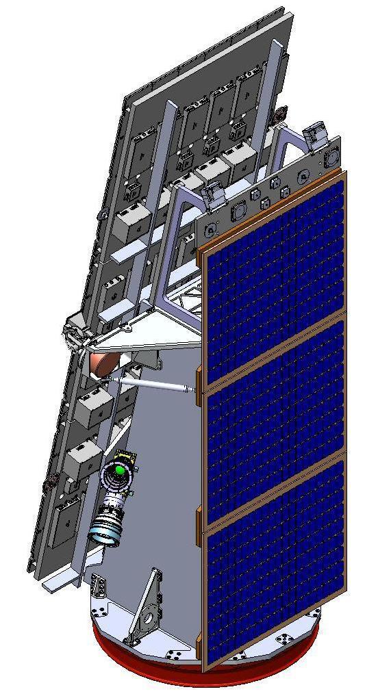
8 NovaSAR-S USU Smallsat
 400kg, 7yr lifetime, 24month lead time HH, HV, VH, VV")


9 NovaSAR-S Heritage avionics, bespoke structure S-band payload (Astrium) 400kg, 7yr lifetime, 24month lead time HH, HV, VH, VV polarisation options >2min imaging per orbit Payload antenna 3x1m Designed as a solution for medium resolution, existing applications where there is a market for more data or a desire for a national capability Packaging optimised rather than imaging performance USU Smallsat


10 Payload 18 phase centres: Transmit unit Receive unit Radiator unit Power conditioning unit Tx/Rx phase adjustment for beam shape and beam steering flexibility Frontend redundancy by graceful degradation Cold redundant dual payload backends S-band due to transmit units Commercially available GaN amplifiers Efficiency important for SAR payload >40% achieved Relatively mature technology at S-band USU Smallsat
11 Orbit flexibility Optimum altitude 580km Designed for multiple orbits: Sun synchronous polar orbit (LTAN 10.30) Equatorial orbit (15degree inclination) Minor mechanical changes - AOCS actuators Could be deployed in dawn/dusk orbit (LTAN 06.00) with additional NRE USU Smallsat


12 Development so far Satellite and payload design well advanced Astrium airborne trial collecting S-/X-band data Initial study by Surrey Space Centre Paper presented at APSAR 2011 Paper accepted for EUSAR 2012 Funding for PhD studentship secured Engaging with other academics Payload ground demonstrator 1/3 size antenna Inverse SAR test using ISS as target Early flight of front end technology on TechDemoSat-1 Q One phase centre of SAR payload used as an altimeter 50m Range Azimuth USU Smallsat


13 Airborne Results USU Smallsat


14 Airborne Results S-Band X-band Google Earth USU Smallsat


15 Airborne results, processed to simulate the results of the 6m resolution spaceborne system Airborne Results USU Smallsat
16 Changing the economics of space Baseline Capability

17 NovaSAR-S Baseline Imaging Modes Mode Incidence angles Res. Typical Swath Sensitivity (NEσ0) Ambiguity ratio * range only m 100km <-18dB <-16dB 4 No. of looks m 750km <-12dB <-18dB* N/A m 15-20km <-17.5dB <-16dB m 150km <-19dB <-16dB 4 Mode 1 20m resolution (like medium resolution optical imagers) plus max swath Typical mode for most target applications Mode 2 Maritime surveillance Mode 3 Trade swath for 6m resolution but maintain image quality Mode 4 Like mode 1 but trade resolution a bit for more swath Modes 1,2,4 scansar, mode 3 stripmap Baseline modes can be tuned in orbit by adjusting the pulse repetition frequency and beam steering USU Smallsat
18 Revisits Maximum and average revisit times in days: Mode SSO LTAN 10:30 Equatorial 15 Orbit 1 (20m) 2 (maritime) 3 (6m) 4 (30m) 1 sat 3 sats 1 sat 3 sats Av 4.4 Max14.0 Av0.9 Max8.0 Av3.2 Max12.5 Av 3.7 Max13.0 Av 1.5 Max3.5 Av0.3 Max0.5 Av1.1 Max3.5 Av 1.2 Max3.5 Av 1.3 Max6.2 Av0.5 Max0.9 Av0.9 Max2.2 Av 1.0 Max2.4 Av 0.4 Max1.0 Av0.2 Max0.8 Av0.3 Max0.9 Av 0.3 Max0.9 Where revisit means any opportunity using left/right imaging to image one location USU Smallsat
19 Throughput and duty cycle Assuming 2min (~2%) imaging per orbit: Mode 10 6 km 2 per day 1 (20m) (maritime) (6m) (30m) 1.8 Actual payload duty cycle dependent on orbit, mode, power, data storage, data downlinking, thermal considerations and groundstation number/location USU Smallsat
20 Changing the economics of space First NovaSAR mission
21 Status UK government grant announced in autumn budget statement to fund first satellite of NovaSAR constellation Other partners being sought by SSTL to complete the funding required to get to orbit 25% of capacity reserved 75% available Bulk data provision by SSTL/DMCii (raw, Level 1) Service provision by Astrium GEO Information Services KO May 2012 Flight readiness review April 2014 USU Smallsat
22 Ground segment TBC Northern/Equatorial Groundstation rented capacity SSTL S-/X-band Groundstation (Bordon) SSTL S-band Groundstation (Guildford) ISIC S-/X-band Groundstation (Chilbolton) ISIC S-band Groundstation (Harwell) Based on heritage SSTL systems Exact system TBC Nominal operations file transfer based and autonomous Service interface via Astrium Geo Information Services Payload tasking by DMCii/Astrium Housekeeping by SSTL Primary facilities possibly hosted by ISIC (EO Hub at Harwell, UK): Payload operations and data archiving Spacecraft operations Groundstation antennas SSTL/DMCii facilities used as backup ISIC KEY SSTL facility ISIC facility DMCii facility Other facility H/W S/W S/C operator (ISIC/SSTL) P/L operator (ISIC/DMCii) SRU CEMS AIC Rack PC Spacecraft Operation Centre (Guildford) Spacecraft Operation Centre (EO Hub Harwell) 4 x Windows PCs S-Band Chain S-Band Signal Generator CDM 600 (PSK modem) Data Switch/FSK Modem Router Upload Program (SW) SW Telemetry Display & processing SW File Handling SW / FTP Server Mission Operations Centre (Guildford) Mission Operations Centre (EO Hub Harwell) Mission Planning System (SW) NovaSAR MPS PC Antenna System (inc Amps & up/down Converters) Astrium P/L operator ARQ Msgs Automation System SW Orbital Elements (tle s) Raw, L1 and quicklook data Archive Users HMG, academia, industry X-Band Chain Demodulator Image Capture System (data buffer) Data Capture PC Images SW Decryption/ Decompression SW Image Handling Chain Image processor Astrium GEO Information Services Service development USU Smallsat
23 Secondary Payloads Small secondary payloads being considered Only minor mechanical changes to satellite possible Should not affect SAR performance, schedule etc. AIS currently SSTL preferred option Contemporaneous AIS/Radar Data USU Smallsat
24 NovaSAR-S Summary Low cost, medium resolution system Flexible modes of operation Launch 2014 of first satellite in constellation Investigating secondary AIS payload Looking for partners! USU Smallsat


25 Thank you USU Smallsat
TechDemoSat-1 & NovaSAR-S
 TechDemoSat-1 & NovaSAR-S Lily Dodemant / Peter Fletcher UKSA Ground Segment Team 6th June 2012 http://www.bis.gov.uk/ukspaceagency TechDemoSat-1 Objectives A technology demonstration satellite project
Affordable space based radar for homeland security
 Changing the economics of space Affordable space based radar for homeland security Adam Baker Brent Abbott Phil Whittaker Rachel Bird Luis Gomes Summary Why Radar? However: Radar data is expensive Users
Commissioning of the NigeriaSat-2 High Resolution Imaging Mission
 Changing the economics of space Commissioning of the NigeriaSat-2 High Resolution Imaging Mission Phil Davies (presenting) SSTL Francis Chizea - NASRDA Andrew Cawthorne SSTL Andrew Carrel - SSTL Luis Gomes
HEMERA Constellation of passive SAR-based micro-satellites for a Master/Slave configuration
 HEMERA Constellation of passive SAR-based micro-satellites for a Master/Slave HEMERA Team Members: Andrea Bellome, Giulia Broggi, Luca Collettini, Davide Di Ienno, Edoardo Fornari, Leandro Lucchese, Andrea
SAR Interferometry Capabilities of Canada's planned SAR Satellite Constellation
 SAR Interferometry Capabilities of Canada's planned SAR Satellite Constellation Dirk Geudtner, Guy Séguin,, Ralph Girard Canadian Space Agency RADARSAT Follow-on Program CSA is in the middle of a Phase
Introduction to KOMPSAT
 Introduction to KOMPSAT September, 2016 1 CONTENTS 01 Introduction of SIIS 02 KOMPSAT Constellation 03 New : KOMPSAT-3 50 cm 04 New : KOMPSAT-3A 2 KOMPSAT Constellation KOMPSAT series National space program
RADARSAT-2 Program Update Daniel De Lisle Canadian Space Agency
 RADARSAT-2 Program Update Daniel De Lisle Canadian Space Agency Presentation outline RADARSAT-1 Update RADARSAT-2 Mission description Mission Objectives System Characteristics Data Commercialization/Allocation
SAR missions for oceanography at the European Space Agency
 SAR missions for oceanography at the European Space Agency ERS-1, ERS-2, Envisat, Sentinel-1A, Sentinel-1B, ESA 3 rd Party Missions (ALOS) Prepared by ESA teams and ESA supporting companies ESA and SAR
Rich Data, Cheap Satellites
 SSC17-XI-06 Rich Data, Cheap Satellites Luis Gomes, Nimal Navarthinam, Andrew Cawthorne, Alex da Silva Curiel Surrey Satellite Technology Limited 20 Stephenson Road, Guildford, GU2 7YE, United Kingdom;
Sentinel-1 System Overview
 Sentinel-1 System Overview Dirk Geudtner, Rámon Torres, Paul Snoeij, Malcolm Davidson European Space Agency, ESTEC Global Monitoring for Environment and Security (GMES) EU-led program aiming at providing
KOMPSAT Constellation. November 2012 Satrec Initiative
 KOMPSAT Constellation November 2012 Satrec Initiative KOMPSAT Constellation KOMPSAT National program Developed and operated by KARI (Korea Aerospace Research Institute) Dual use : Government & commercial
Prague - 29 June 2009 A. COLETTA COLETTA. COSMO-SkyMed Mission: COSMO-SkyMed Mission. Application and Data Access
 A. A. COLETTA COLETTA COSMO-SkyMed COSMO-SkyMed Mission Mission Manager Manager ITALIAN ITALIAN SPACE SPACE AGENCY AGENCY COSMO-SkyMed Mission: Application and Data Access The COSMO-SkyMed PROGRAMME The
WHAT IS NEXT IN EARTH OBSERVATION. SkyMed Mission
 WHAT IS NEXT IN EARTH OBSERVATION COSMO-SkyMed SkyMed Mission Paolo Ammendola Italian Space Agency Florence, Sept. 19, 2001 ammendola@asi asi.it THE NEEDS Market studies indicate that the value of the
Polarisation Capabilities and Status of TerraSAR-X
 Polarisation Capabilities and Status of TerraSAR-X Irena Hajnsek, Josef Mittermayer, Stefan Buckreuss, Kostas Papathanassiou German Aerospace Center Microwaves and Radar Institute irena.hajnsek@dlr.de
The Current Status and Brief Results of Engineering Model for PALSAR-2 onboard ALOS-2 and Science Project
 The Current Status and Brief Results of Engineering Model for PALSAR-2 onboard ALOS-2 and Science Project + The 16 th KC meeting Japan Aerospace Exploration Agency Masanobu Shimada, Yukihiro KANKAKU The
Sentinel-1 Overview. Dr. Andrea Minchella
 Dr. Andrea Minchella 21-22/01/2016 ESA SNAP-Sentinel-1 Training Course Satellite Applications Catapult - Electron Building, Harwell, Oxfordshire Contents Sentinel-1 Mission Sentinel-1 SAR Modes Sentinel-1
KONGSBERG SATELLITE SERVICES Earth Observation for Maritime Operations Current Capabilities and Future Potential
 KONGSBERG SATELLITE SERVICES 2017 Earth Observation for Maritime Operations Current Capabilities and Future Potential Andreas Hay Kaljord Project Manager KSAT HQ IN TROMSØ - 69N WELCOME TO TROMSØ Established
KONGSBERG SATELLITE SERVICES 2017 Line Steinbakk, Director Programs. Himmel og hav - Ålesund 3. Oktober 2017
 KONGSBERG SATELLITE SERVICES 2017 Line Steinbakk, Director Programs Himmel og hav - Ålesund 3. Oktober 2017 KSAT HQ IN TROMSØ 69N Established in 1967 Kongsberg Satellite Services since 2002 World leading
Biomass, a polarimetric interferometric P-band SAR mission
 Biomass, a polarimetric interferometric P-band SAR mission M. Arcioni, P. Bensi, M. Fehringer, F. Fois, F. Heliere, N. Miranda, K. Scipal Fringe 2015, ESRIN 27/03/2015 The Biomass Mission 1. Biomass was
7.7 TerraSAR-X & TanDEM-X
 7.7 TerraSAR-X & TanDEM-X Two Innovative Remote Sensing Stars for space-borne Earth Observation Vorlesung Wolfgang Keydel Microwaves and Radar Institute, German Aerospace Research Center (DLR), D-82230
COSMO-SkyMed Mission Status Presented by Fabrizio BATTAZZA (ASI)
") COSMO-SkyMed Mission Status Presented by Fabrizio BATTAZZA (ASI) COSMO-1 & COSMO-2 LAUNCHES FIRST SATELLITE OF THE CONSTELLATION SUCCESSFULLY LAUNCHED 08 June 2007 03:35 (GMT) Vandenberg U.S.A. Air Force
COSMO-SkyMed Mission Status Presented by Fabrizio BATTAZZA (ASI) COSMO-1 & COSMO-2 LAUNCHES FIRST SATELLITE OF THE CONSTELLATION SUCCESSFULLY LAUNCHED 08 June 2007 03:35 (GMT) Vandenberg U.S.A. Air Force
TanDEM-X. 1. Mission Overview. Science Meeting No SAR Imaging Modes & Performance 3. Satellite Design Overview 4. Launcher 5.
 TanDEM-X Science Meeting No. 1 Dresden 15.5.2006 Wolfgang Pitz EADS Astrium GmbH D-88039 Friedrichshafen 1. Mission Overview 2. SAR Imaging Modes & Performance 3. Satellite Design Overview 4. Launcher
Follow that Ground Station! And double the data throughput using polarization diversity.
 SSC09-VI-8 Follow that Ground Station! And double the data throughput using polarization diversity. Peter Garner, Nigel Phillips, Andrew Cawthorne, Alex da Silva Curiel, Phil Davies, Lee Boland Surrey
The Biomass Mission, status of the satellite system
 The Biomass Mission, status of the satellite system M. Arcioni, P. Bensi, M. Fehringer, F. Fois, F. Heliere, K. Scipal PolInSAR/Biomass Meeting 2015, ESRIN 29/01/2015 1. Key facts (lifetime, duty cycle
VenSAR: A MULTI-FUNCTIONAL S-BAND RADAR FOR THE EnVision MISSION TO VENUS
 VenSAR: A MULTI-FUNCTIONAL S-BAND RADAR FOR THE EnVision MISSION TO VENUS Richard Ghail (1) and David Hall (2) (1) Civil and Environmental Engineering, Imperial College London, London SW7 2AZ, United Kingdom
The Sentinel-1 Constellation
 The Sentinel-1 Constellation Evert Attema, Sentinel-1 Mission & System Manager AGRISAR and EAGLE Campaigns Final Workshop 15-16 October 2007 ESA/ESTECNoordwijk, The Netherlands Sentinel-1 Programme Sentinel-1
Sentinel-1 Calibration and Performance
 Sentinel-1 Calibration and Performance Paul Snoeij Evert Attema Björn Rommen Nicolas Floury Berthyl Duesmann Malcolm Davidson Ramon Torres European Space Agency Sentinel-1 Mission Objectives Component
SURREY GSA CATALOG. Surrey Satellite Technology US LLC 8310 South Valley Highway, 3rd Floor, Englewood, CO
 SURREY CATALOG Space-Qualified flight hardware for small satellites, including GPS receivers, Attitude Determination and Control equipment, Communications equipment and Remote Sensing imagers Professional
Satellite Fleet Operations Using a Global Ground Station Network. Naomi Kurahara Infostellar
 Satellite Fleet Operations Using a Global Ground Station Network Naomi Kurahara Infostellar 1 Japanese university satellites Image via University Space Engineering Consortium, http://unisec.jp/wp/wp-content/uploads/2016/06/unisec_satellites_160120_jp_s.jpg
DMC3 and Carbonite-1: Two Sides of Small Satellites
 SSC16-III-10 DMC3 and Carbonite-1: Two Sides of Small Satellites Nimal Navarathinam, Andrew Cawthorne, Luis Gomes, Martin Sweeting, John Paffet Surrey Satellite Technology Ltd. Tycho House, 20 Stephenson
Presentation to CDW Niels Jernes Vej Aalborg E - Denmark - Phone:
 Presentation to CDW 2014 GomSpace at a Glance A space company situated in Denmark Nano-satellite products & platforms Micro-satellites (tailored products) Re-entry systems & micro-gravity R&D Established
GMES Sentinel-1 Transponder Development
 GMES Sentinel-1 Transponder Development Paul Snoeij Evert Attema Björn Rommen Nicolas Floury Malcolm Davidson ESA/ESTEC, European Space Agency, Noordwijk, The Netherlands Outline 1. GMES Sentinel-1 overview
Developments in GNSS Reflectometry from the SGR-ReSI on TDS-1
 Changing the economics of space Developments in GNSS Reflectometry from the SGR-ReSI on TDS-1 Martin Unwin Philip Jales, Jason Tye (SSTL), Brent Abbott SST-US Christine Gommenginger, Giuseppe Foti (NOC)
Concept of the future L-band SAR mission for wide swath SAR observation
 Concept of the future SAR mission for wide swath SAR observation A.Karasawa 1, Y.Okada 1, Y.Yokota 1, S.Nakamura 1 1) Mitsubishi Electric Corporation 1 Outline 1:Development of SAR systems in MELCO 2:Development
Development of Microsatellite to Detect Illegal Fishing MS-SAT
 Development of Microsatellite to Detect Illegal Fishing MS-SAT Ernest S. C. P. Bintang A.S.W.A.M. Department of Aerospace Engineering Faculty of Mechanical and Aerospace Engineering Institut Teknologi
Big picture with KOMPSAT KOMPSAT-3A / KOMPSAT-3 / KOMPSAT-5 / KOMPSAT-2
 Big picture with KOMPSAT KOMPSAT-3A / KOMPSAT-3 / KOMPSAT-5 / KOMPSAT-2 Big picture with KOMPSAT Introduction SI Imaging Services (SIIS) is the exclusive worldwide marketing and sales representative of
The Ability of a Small Satellite Constellation to Tip and Cue Other Commercial Assets
 Changing the economics of space The Ability of a Small Satellite Constellation to Tip and Cue Other Commercial Assets Becky Cudzilo - Surrey Satellite US, LLC K.C. Foley - GeoEye, Inc. Chandler Smith -
EPS Bridge Low-Cost Satellite
 EPS Bridge Low-Cost Satellite Results of a Concept Study being performed for Dr. Hendrik Lübberstedt OHB-System AG OpSE Workshop Walberberg 8th November 2005 EPS Bridge Key System Requirements Minimum
TerraSAR-X Calibration Status 2 Years in Flight
 2 Years in Flight Dirk Schrank, Marco Schwerdt, Markus Bachmann, Björn Döring, Clemens Schulz November 2009 CEOS 09 VG 1 Calibration Tasks Performed 2009 Introduction Challenge Schedule Re-Calibration
Microwave Remote Sensing (1)
") Microwave Remote Sensing (1) Microwave sensing encompasses both active and passive forms of remote sensing. The microwave portion of the spectrum covers the range from approximately 1cm to 1m in wavelength.
Microwave Remote Sensing (1) Microwave sensing encompasses both active and passive forms of remote sensing. The microwave portion of the spectrum covers the range from approximately 1cm to 1m in wavelength.
Small Satellites: The Execution and Launch of a GPS Radio Occultation Instrument in a 6U Nanosatellite
 Small Satellites: The Execution and Launch of a GPS Radio Occultation Instrument in a 6U Nanosatellite Dave Williamson Director, Strategic Programs Tyvak Tyvak: Satellite Solutions for Multiple Organizations
Copernicus Introduction Lisbon, Portugal 13 th & 14 th February 2014
 Copernicus Introduction Lisbon, Portugal 13 th & 14 th February 2014 Contents Introduction GMES Copernicus Six thematic areas Infrastructure Space data An introduction to Remote Sensing In-situ data Applications
L-BAND ICE-PENETRATING RADAR ON BOARD A SMALL SATELLITE
 L-BAND ICE-PENETRATING RADAR ON BOARD A SMALL SATELLITE Anoop Parthasarathy Mtech. Digital Signal Processing Centre for Emerging Technologies Jain University ACKNOWLEDGEMENTS My sincere thanks to Dr. G.
Preparation for Flight of Next Generation Space GNSS Receivers
 Changing the economics of space Preparation for Flight of Next Generation Space GNSS Receivers ICGPSRO, 14-16 th May 2013 Taiwan #0205691 Commercial in Confidence 1 Overview SSTL and Spaceborne GNSS Small
ERS/ENVISAT ASAR Data Products and Services
 ERS/ENVISAT ASAR Data Products and Services Andrea Celentano Business Manager celentan@eurimage.com What is Eurimage? Founded in 1989 Current shareholders: Since 1989 Commercial Partner of the European
Recent GNSS Reflectometry Results from the UK TDS-1 Satellite
 CHANGING THE ECONOMICS OF SPACE Recent GNSS Reflectometry Results from the UK TDS-1 Satellite Martin Unwin ICGPSRO2018, Taipei, 18-20 April 2018 SSTL 2018 Ack: SSTL, NOC, ESA, Surrey, CEOI, UKSA, InnovateUK,
Microsatellite Constellation for Earth Observation in the Thermal Infrared Region
 Microsatellite Constellation for Earth Observation in the Thermal Infrared Region Federico Bacci di Capaci Nicola Melega, Alessandro Tambini, Valentino Fabbri, Davide Cinarelli Observation Index 1. Introduction
COSMO-SkyMed Mission Status Presented by Giovanni VALENTINI (ASI)
") COSMO-SkyMed Mission Status Presented by Giovanni VALENTINI (ASI) FIRST SATELLITE FIRST SATELLITE OF THE CONSTELLATION SUCCESSFULLY LAUNCHED 08 June 2007 03:35 (GMT) Vandenberg U.S.A. Air Force Base SECOND
COSMO-SkyMed Mission Status Presented by Giovanni VALENTINI (ASI) FIRST SATELLITE FIRST SATELLITE OF THE CONSTELLATION SUCCESSFULLY LAUNCHED 08 June 2007 03:35 (GMT) Vandenberg U.S.A. Air Force Base SECOND
BRIDGING THE ABYSS AGILE DATA DOWNLINK SOLUTIONS FOR THE DISASTER MONITORING CONSTELLATION
 BRIDGING THE ABYSS AGILE DATA DOWNLINK SOLUTIONS FOR THE DISASTER MONITORING CONSTELLATION Mark Brenchley (1), Dr Peter Garner (2), Andrew Cawthorne (3), Katarzyna Wisniewska (4), Philip Davies (5) (1)
Space Systems Engineering
 Space Systems Engineering This course studies the space systems engineering referring to spacecraft examples. It covers the mission analysis and design, system design approach, systems engineering process
CJ Jagadeesha,NDRF-IEI, Bangalore RM Vasagam,Chairman Aerospace Division Board,IEI LVM Reddy,Vice-President,IEI
 CJ Jagadeesha,NDRF-IEI, Bangalore RM Vasagam,Chairman Aerospace Division Board,IEI LVM Reddy,Vice-President,IEI D] Geo informatics for assessing EWS in watersheds E] DSS for EW communication and policy
Development Status of Compact X-band Synthetic Aperture Radar Compatible with a100kg-class SAR Satellite and Its Future Plan.
 SSC17-IX-01 Development Status of Compact X-band Synthetic Aperture Radar Compatible with a100kg-class SAR Satellite and Its Future Plan Hirobumi Saito Japan Aerospace Exploration Agency (JAXA), Institute
UKube-1 Platform Design. Craig Clark
 UKube-1 Platform Design Craig Clark Ukube-1 Background Ukube-1 is the first mission of the newly formed UK Space Agency The UK Space Agency gave us 5 core mission objectives: 1. Demonstrate new UK space
MULTI-CHANNEL SAR EXPERIMENTS FROM THE SPACE AND FROM GROUND: POTENTIAL EVOLUTION OF PRESENT GENERATION SPACEBORNE SAR
 3 nd International Workshop on Science and Applications of SAR Polarimetry and Polarimetric Interferometry POLinSAR 2007 January 25, 2007 ESA/ESRIN Frascati, Italy MULTI-CHANNEL SAR EXPERIMENTS FROM THE
TerraSAR-X Mission: Application and Data Access
 TerraSAR-X Mission: Application and Data Access Irena Hajnsek & TSX TEAM German Aerospace Center Microwaves and Radar Institute Pol-InSAR Research Group 2 years in Orbit (since June 2007) irena.hajnsek@dlr.de
Collaborative use of SAR and AIS data from NovaSAR-S for Maritime Surveillance
 Collaborative use of SAR and AIS data from NovaSAR-S for Maritime Surveillance Lotfi Achiri, University of Surrey, Surrey Space Centre, l.achiri@surrey.ac.uk, UK Raffaella Guida, University of Surrey,
COPERNICUS COLLABORATIVE GROUND SEGMENT TO SUPPORT MARITIME SITUATIONAL AWARENESS
 COPERNICUS COLLABORATIVE GROUND SEGMENT TO SUPPORT MARITIME SITUATIONAL AWARENESS D. Krause*, E. Schwarz, H. Damerow, German Aerospace Center (DLR), German Remote Sensing Data Center (DFD), Kalkhorstweg
New Technologies for Future EO Instrumentation Mick Johnson
 New Technologies for Future EO Instrumentation Mick Johnson Director of CEOI Monitoring the Earth from Space What data do EO satellites provide? Earth Observation science Operational services Weather,
National Aeronautics and Space Administration Jet Propulsion Laboratory California Institute of Technology
 QuikSCAT Mission Status QuikSCAT Follow-on Mission 2 QuikSCAT instrument and spacecraft are healthy, but aging June 19, 2009 will be the 10 year launch anniversary We ve had two significant anomalies during
InnoSat and MATS An Ingenious Spacecraft Platform applied to Mesospheric Tomography and Spectroscopy
 Niclas Larsson N. Larsson, R. Lilja (OHB Sweden), M. Örth, S. Söderholm (ÅAC Microtec), J. Köhler, R. Lindberg (SNSB), J. Gumbel (MISU) SATELLITE SYSTEMS InnoSat and MATS An Ingenious Spacecraft Platform
Annex B: HEO Satellite Mission
 Annex B: HEO Satellite Mission Table of Content TABLE OF CONTENT...I 1. INTRODUCTION...1 1.1. General... 1 1.2. Response Guidelines... 1 2. BRAODBAND CAPACITY...2 2.1. Mission Overview... 2 2.1.1. HEO
PAZ Product Definition
 PAZ Product Definition CALVAL Centre Juan Manuel Cuerda Muñoz, Javier del Castillo Mena, Adolfo López Pescador, Nuria Gimeno Martínez, Nuria Casal Vázquez, Patricia Cifuentes Revenga, Marcos García Rodríguez,
Geospatial Vision and Policies Korean Industry View 26 November, 2014 SI Imaging Services
 Geospatial Vision and Policies Korean Industry View 26 November, 2014 SI Imaging Services Distribution Limitation, SI Imaging Services Proprietary Data : The data contained in this document, without the
1. Detect and locate potentially illegal fishing ship using satellite image, AIS data, and external sources.
 Title: Development of Microsatellite to Detect Illegal Fishing MS-SAT Primary Point of Contact (POC) & email: Dr. Ridanto Eko Poetro; ridanto@ae.itb.ac.id Co-authors: Ernest Sebastian C., Bintang A.S.W.A.M.
Satellite data for Maritime Operations. Andreas Hay Kaljord Project Manager Energy, Environment & Security
 Satellite data for Maritime Operations Andreas Hay Kaljord Project Manager Energy, Environment & Security Kongsberg Satellite Services (KSAT) World leading provider within our business area Supports 85
RADARSAT-1: An End-of-Mission Review of the Imaging and Calibration Performance of a Magnificent Canadian Instrument
 RADARSAT-1: An End-of-Mission Review of the Imaging and Calibration Performance of a Magnificent Canadian Instrument S. Cote, S. Srivastava Canadian Space Agency S. Muir Calian Technologies Ltd 1 RADARSAT-1
DRONACHARYA GROUP OF INSTITUTIONS, GREATER NOIDA. SATELLITE COMMUNICATIONS (EEC 021) QUESTION BANK
 QUESTION BANK") DRONACHARYA GROUP OF INSTITUTIONS, GREATER NOIDA. SATELLITE COMMUNICATIONS (EEC 021) QUESTION BANK 1. Write the advantages and disadvantages of Satellite Communication. 2. Distinguish between active and
DRONACHARYA GROUP OF INSTITUTIONS, GREATER NOIDA. SATELLITE COMMUNICATIONS (EEC 021) QUESTION BANK 1. Write the advantages and disadvantages of Satellite Communication. 2. Distinguish between active and
KONGSBERG. WORLD CLASS through people, technology and dedication WORLD CLASS through people, technology and dedication
 WORLD CLASS through people, technology and dedication WORLD CLASS through people, technology and dedication Skipsdeteksjon fra radarsatellitter SkipSat Richard Hallr Kongsberg Satellite Services AS (KSAT)
Disruptive technologies and future trends of small satellites
 2016 SSTL Disruptive technologies and future trends of small satellites Luis Gomes Director of EO & science Surrey Satellite Technology Limited Radio Communication June 1978 2016 SSTL The DMC and RapidEye
School of Rural and Surveying Engineering National Technical University of Athens
 Laboratory of Photogrammetry National Technical University of Athens Combined use of spaceborne optical and SAR data Incompatible data sources or a useful procedure? Charalabos Ioannidis, Dimitra Vassilaki
SAOCOM-CS Mission and ESA Airborne Campaign Data
 SAOCOM-CS Mission and ESA Airborne Campaign Data Malcolm Davidson Head of the EOP Campaign Section Malcolm.Davidson@esa.int Objectives of presentation Introduce a new type of ESA SAR mission with Polarimetrice,
Galileo signal reflections used for monitoring waves and weather at sea
 Press Release Monday 26 th November 2007 Galileo signal reflections used for monitoring waves and weather at sea Surrey Satellite Technology Ltd (SSTL) and the University of Surrey have succeeded for the
Introduction Active microwave Radar
 RADAR Imaging Introduction 2 Introduction Active microwave Radar Passive remote sensing systems record electromagnetic energy that was reflected or emitted from the surface of the Earth. There are also
*For International Stewardship of the Maritime Environment and its Resources. Photo
 *For International Stewardship of the Maritime Environment and its Resources *For Maritime Safety *For Security Photo # Providing Environmental Monitoring* # Increasing Security* # Enabling Safety Efforts*
ALOS and PALSAR. Masanobu Shimada
 ALOS and PALSAR Masanobu Shimada Earth Observation Research Center, National Space Development Agency of Japan, Harumi 1-8-10, Harumi island triton square office tower X 22, Chuo-Ku, Tokyo-To, Japan, 104-6023,
SAMARA Satellite communication system for Atm service
 SAMARA Satellite communication system for Atm service System & Payload Solutions for Small GEO Platforms ESTEC Noordwijk, 6th February 2009 Thales Alenia Space Italia Thales Alenia Space Espana Thales
NASA Spectrum Management Update: WRC-11 Issues and Objectives and Domestic Concerns
 NASA Spectrum Management Update: WRC-11 Issues and Objectives and Domestic Concerns CORF Spring Meeting May 27, 2009 John Zuzek NASA Remote Sensing Spectrum Manager Agenda Overview WRC-11 Issues of Primary
Synthetic Aperture Radar
 Synthetic Aperture Radar Picture 1: Radar silhouette of a ship, produced with the ISAR-Processor of the Ocean Master A Synthetic Aperture Radar (SAR), or SAR, is a coherent mostly airborne or spaceborne
SAR Imagery: Airborne or Spaceborne? Presenter: M. Lorraine Tighe PhD
 SAR Imagery: Airborne or Spaceborne? Presenter: M. Lorraine Tighe PhD Introduction The geospatial community has seen a plethora of spaceborne SAR imagery systems where there are now extensive archives
Development in GNSS Space Receivers
 International Technical Symposium on Navigation and Timing November 16th, 2015 Development in GNSS Space Receivers Lionel RIES - CNES 1 C O GNSS in Space : Use-cases and Challenges Receivers State-of-the-Art
2009 Small Satellite Conference Logan, Utah
 Exploiting Link Dynamics in LEO-to-Ground Communications 2009 Small Satellite Conference Logan, Utah Joseph Palmer jmp@lanl.gov Michael Caffrey mpc@lanl.gov Los Alamos National Laboratory Paper Abstract
Changing the economics of space. Redefining the word Responsive in Operationally Responsive Space
 Changing the economics of space Redefining the word Responsive in Operationally Responsive Space Dr. Stuart Eves s.eves@sstl.co.uk SSTL February 2009 Defining Responsive Responsive means flexible and agile,
TerraSAR-X: Status Report & Polarimetric Data Exploitation
 TerraAR-X: tatus Report & Polarimetric Data Exploitation Alberto Moreira & Irena Hajnsek German Aerospace Center (DLR) Folie irena.hajnsek@dlr.de - 5.0.007 TerraAR-X: A National cience Mission with Commercial
Emergency Locator Signal Detection and Geolocation Small Satellite Constellation Feasibility Study
 Emergency Locator Signal Detection and Geolocation Small Satellite Constellation Feasibility Study Authors: Adam Gunderson, Celena Byers, David Klumpar Background Aircraft Emergency Locator Transmitters
CubeSat Developers Workshop 2014
 CubeSat Developers Workshop 2014 IPEX Intelligent Payload EXperiment Eric Baumgarten 4/23/14 CubeSat Workshop 2014 1 IPEX Mission Summary 1U Cubesat in collaboration with JPL Cal Poly s PolySat constructed
GNSS MONITORING NETWORKS
 SPACE GNSS MONITORING NETWORKS Satellite communications, earth observation, navigation and positioning and control stations indracompany.com GNSS MONITORING NETWORKS GNSS MONITORING NETWORKS Indra s solutions
CYGNSS Mission Update
 International Ocean Vector Wind Science Team Meeting Portland, OR 19-21 May 2015 CYGNSS Mission Update Chris Ruf (1) CYGNSS Principal Investigator Paul Chang (2), Maria Paola Clarizia (1), Scott Gleason
CNES PRIORITIES IN POLAR AND CRYOSPHERE RESEARCH
 Polar Space Task Group 3rd Session CNES PRIORITIES IN POLAR AND CRYOSPHERE RESEARCH Juliette Lambin, Steven Hosford Wednesday, May 22th, 2013 Paris, France 1 OUTLINE CNES MISSIONS FOR POLAR/CRYOSPHERE
Platform Independent Launch Vehicle Avionics
 Platform Independent Launch Vehicle Avionics Small Satellite Conference Logan, Utah August 5 th, 2014 Company Introduction Founded in 2011 The Co-Founders blend Academia and Commercial Experience ~20 Employees
GomSpace Presentation to Hytek Workshop
 GomSpace Presentation to Hytek Workshop Presented by: Lars K. Alminde Managing Director GomSpace Aps alminde@gomspace.com Do not redistribute without permission GomSpace at a Glance University spin-off
EARTH OBSERVATION WITH SMALL SATELLITES
 EARTH OBSERVATION WITH SMALL SATELLITES AT THE FUCHS-GRUPPE B. Penné, C. Tobehn, M. Kassebom, H. Lübberstedt OHB-System GmbH, Universitätsallee 27-29, D-28359 Bremen, Germany www.fuchs-gruppe.com ABSTRACT
Upstream UK Capabilities. Rob Scott
 Upstream UK Capabilities Rob Scott Platforms LEO, MEO, GEO Cube-, Nano-, Micro-, Small- and Large-sats Deployable in high inclination LEO, or HEO/Molnya if needed High Altitude Platforms (winged and dirigible)
Outernet: Development of a 1U Platform to Enable Low Cost Global Data Provision
 Outernet: Development of a 1U Platform to Enable Low Cost Global Data Provision Introduction One of the UK s leading space companies, and the only wholly UK-owned Prime contractor. ISO 9001:2008 accredited
SAR Remote Sensing (Microwave Remote Sensing)
") iirs SAR Remote Sensing (Microwave Remote Sensing) Synthetic Aperture Radar Shashi Kumar shashi@iirs.gov.in Electromagnetic Radiation Electromagnetic radiation consists of an electrical field(e) which
iirs SAR Remote Sensing (Microwave Remote Sensing) Synthetic Aperture Radar Shashi Kumar shashi@iirs.gov.in Electromagnetic Radiation Electromagnetic radiation consists of an electrical field(e) which
Incorporating a Test Flight into the Standard Development Cycle
 into the Standard Development Cycle Authors: Steve Wichman, Mike Pratt, Spencer Winters steve.wichman@redefine.com mike.pratt@redefine.com spencer.winters@redefine.com 303-991-0507 1 The Problem A component
Relative Cost and Performance Comparison of GEO Space Situational Awareness Architectures
 Relative Cost and Performance Comparison of GEO Space Situational Awareness Architectures Background Keith Morris Lockheed Martin Space Systems Company Chris Rice Lockheed Martin Space Systems Company
CubeSat Integration into the Space Situational Awareness Architecture
 CubeSat Integration into the Space Situational Awareness Architecture Keith Morris, Chris Rice, Mark Wolfson Lockheed Martin Space Systems Company 12257 S. Wadsworth Blvd. Mailstop S6040 Littleton, CO
RemoveDebris Mission: Briefing to UNCOPUOS
 Changing the economics of space RemoveDebris Mission: Briefing to UNCOPUOS 9 th Feb 2015 Chris Saunders Surrey Satellite Technology Limited Guildford, United Kingdom RemoveDebris Mission RemoveDebris is
Utilization of Radar data for Maritime Surveillance
 INDESO Project Utilization of Radar data for Maritime Surveillance DENDY MAHABROR MARINE RESEARCH CENTER INDESO RADAR GROUND STATION RADARSAT-2 AND COSMO-SKYMED BALI INDESO satelit VMS satelite radar vessel
Introduction. Satellite Research Centre (SaRC)
") SATELLITE RESEARCH CENTRE - SaRC Introduction The of NTU strives to be a centre of excellence in satellite research and training of students in innovative space missions. Its first milestone satellite
SATELLITE RESEARCH CENTRE - SaRC Introduction The of NTU strives to be a centre of excellence in satellite research and training of students in innovative space missions. Its first milestone satellite