Introduction to KOMPSAT
|
|
|
- Wilfred Owen
- 5 years ago
- Views:
Transcription

1 Introduction to KOMPSAT September,
2 CONTENTS 01 Introduction of SIIS 02 KOMPSAT Constellation 03 New : KOMPSAT-3 50 cm 04 New : KOMPSAT-3A 2
 Dual use : Government & commercial Worldwide")
 KOMPSAT-2 Design lifetime : 3 years 2006.7.28 ~ 1.")

3 KOMPSAT Constellation KOMPSAT series National space program Developed and operated by KARI (Korea Aerospace Research Institute) Dual use : Government & commercial Worldwide imagery distribution by KOMPSAT-5 Design lifetime : 5 years ~ 1.0 m SAR Payload LTAN : 6:00 (18:00) KOMPSAT-2 Design lifetime : 3 years ~ 1.0 m EO Payload LTAN : 10:50 KOMPSAT-3 Design lifetime : 4 years ~ 0.7 m EO Payload LTAN : 13:30 KOMPSAT-3A Design lifetime : 4 years ~ 0.55 m EO & 5.5 m IR Payload LTAN : 13:30 4
4 KOMPSAT Constellation KOMPSAT-2 Specification Launch 28 July, 2006 Ground Sampling Distance Swath Width Spectral Bands Location Accuracy Tilt Angle Data Quantization Orbit Duty PAN : km(nadir) MS : km(nadir) 15 km (nadir) PAN MS1 (Blue) : 500 ~ 900 nm : 450 ~ 520 nm MS2 (Green) : 520 ~ 600 nm MS3 (Red) MS4 (NIR) < 50.9 m CE90 Roll(-30~30 deg.) 10 bits / pixel : 630 ~ 690 nm : 760 ~ 900 nm Sun Synchronous Orbit Altitude : 685 km Inclination : deg. MLTAN : 10:50 20% per orbit 5 KOMPSAT-2 s Strength Huge archive over lifetime
5 Kompsat 2 example Sweden 1: Original image LM 1 m res, 8bit rgb 2: Kompsat 2 image, 1m res, 16 bit -> 8bit 3: Change detection PCI 6 Can we do this better? Use 16 bit RGB+IR
6 Kompsat 2 example Sweden 1: Original image LM 1 m res, 8bit rgb 2: Kompsat 2 image, 1m res, 16 bit -> 8bit 3: Change detection PCI 7 Can we do this better? Use 16 bit RGB+IR


7 Kompsat 2 example Sweden 1: Original image LM 1 m res, 8bit rgb 2: Kompsat 2 image, 1m res, 16 bit -> 8bit 3: Change detection PCI 8 Can we do this better? Use 16 bit RGB+IR

8 9 Tokyo, Japan

9 Quirinopolis, Brazil KOMPSAT Constellation 10
10 KOMPSAT Constellation KOMPSAT-3 Specification Launch 17 May, 2012 Ground Sampling Distance Swath Width Spectral Bands Location Accuracy Tilt Angle Data Quantization Orbit Duty PAN : km(nadir) MS : km(nadir) 16 km (nadir) PAN MS1 (Blue) : 450 ~ 900 nm : 450 ~ 520 nm MS2 (Green) : 520 ~ 600 nm MS3 (Red) MS4 (NIR) < 48.5 m CE90 : 630 ~ 690 nm : 760 ~ 900 nm Roll(-45~45 deg.) / Pitch(-30~30 deg.) 14 bits / pixel Sun Synchronous Orbit Altitude : ± 1 km Inclination : ± 0.05 deg. MLTAN : 13:30 +10/-15 min 10% per orbit 11 What s NEW? 50cm product processed

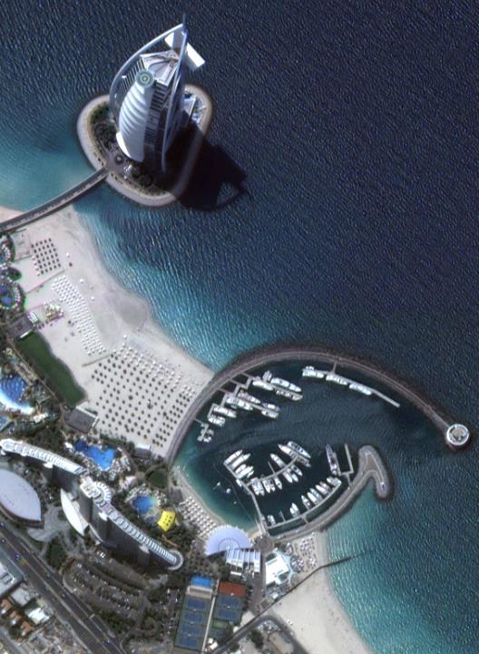
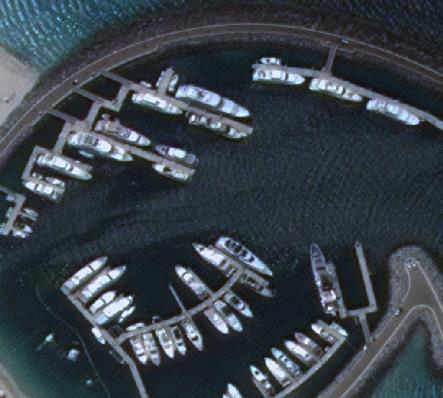
11 KOMPSAT Constellation Dubai, UAE 12

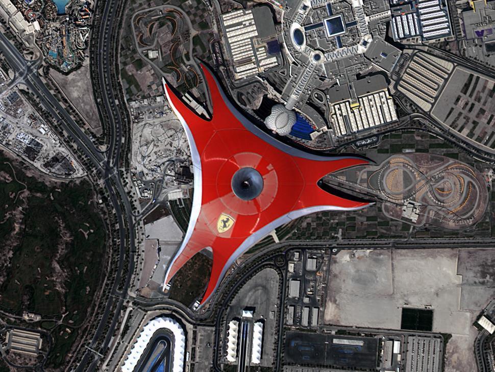
12 KOMPSAT Constellation Sidoarjo, Indonesia 13
 -17 db 1 db 20 ~ 45 deg. (nominal, 304 km coverage) 45 ~ 55 deg.")
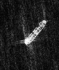
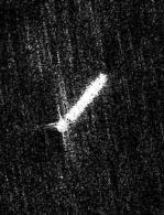
13 KOMPSAT Constellation KOMPSAT-5 Specification Launch 22 August, 2013 Payload Frequency NESZ Radiometric Accuracy Incidence Angles Synthetic Aperture Radar (SAR) 9.66 GHz (X-band) -17 db 1 db 20 ~ 45 deg. (nominal, 304 km coverage) 45 ~ 55 deg. (extended, additional 186 km coverage) Orbit Duty Imaging Mode Sun Synchronous, Dawn-dusk orbit Altitude : 550 km Inclination : 97.6 deg. Local Time : 6 A.M. and 6 P.M. 2 minutes per orbit Spotlight (HR, UH, EH) Strip (ST, ES) ScanSAR (WS, EW) What s NEW? New Imaging Modes, Quality Improvement 14

14 KOMPSAT Constellation 15 KOMPSAT-5 Imagery EH-12, , Hrazdan Central Stadium, Armenia
 >13km (nadir) PAN : 450 ~ 900 nm MS1 (Blue) : 450 ~ 520 nm MS2 (Green) : 520 ~ 600 nm MS3 (Red) MS4 (NIR) : 630 ~ 690 nm : 760 ~ 900 nm Roll(-45~45 deg.")
15 KOMPSAT Constellation KOMPSAT-3A Specification Launch March 26, 2015 Ground Sampling Distance Swath Width Spectral Bands Tilt Angle Data Quantization Orbit PAN : km(nadir) MS : km(nadir) >13km (nadir) PAN : 450 ~ 900 nm MS1 (Blue) : 450 ~ 520 nm MS2 (Green) : 520 ~ 600 nm MS3 (Red) MS4 (NIR) : 630 ~ 690 nm : 760 ~ 900 nm Roll(-45~45 deg.) / Pitch(-30~30 deg.) 14 bits / pixel Sun Synchronous Orbit Altitude : 528 km Inclination : 97.5 deg. MLTAN : 13:30 What s NEW? 40cm product processed 16

16 KOMPSAT Constellation 17
17 KOMPSAT Constellation 18

18 Benefits of KOMPSAT Capacity & Capability Best Choice for Large Area Mapping Large daily collection capability KOMPSAT-2 KOMPSAT-3 KOMPSAT-5 KOMPSAT-3A Total Coverage(km 2 ) 1,700, ,000 Up to 1,000, ,000 Up to 3,240,000 KOMPSAT-2 Higher duty cycle 7900 km strip in 1 imaging KOMPSAT-3 Higher imaging chance to VHR users More than 40 imaging in a month Imaging over one month (11 Oct. ~ 10 Nov.) 20


19 Search for satellites over Oslo 21 Preview is nice
20 Benefits of KOMPSAT Unique combination of VHR EO & SAR Combination of VHR EO & SAR Integrated solution for optical and radar Unique combination for imaging time (10:50, 13:30, 06:00/18:00) Sole VHR sensor with multispectral in the afternoon Increase visibility of specific target (cloud cover changes) Change detection even within a day is possible 06:00 KOMPSAT- 5 COSMO-SkyMed TerraSAR-X 13:30 KOMPSAT-3 KOMPSAT-3A EROS-B (Mono) 11:00 KOMPSAT-2 WorldView-1/2/3 Pleiades 18:00 KOMPSAT-5 COSMO-SkyMed TerraSAR-X 23

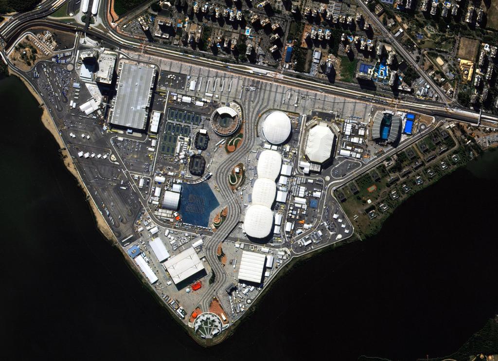
21 Benefits of KOMPSAT Unique combination of VHR EO & SAR All weather imaging SAR Valuable for disaster monitoring (ex. Volcano Popocatépetl, Mexico) KOMPSAT-3 (19 April, 2016) KOMPSAT-5 (21 April, 2016) 24


22 Benefits of KOMPSAT Unique combination of VHR EO & SAR Optic & SAR imagery Different features Tokyo Big Egg, Google image and KOMPSAT-5 image taken on May 11st,

23 Benefits of KOMPSAT The best for spectral analysis Highest Quantization Highest bits per pixel among the commercial imagery 14 bits per pixel Better performance for spectral analysis 26


24 Benefits of KOMPSAT The best for spectral analysis More Information from Bathymetry 11 bits [2048] vs. 14 bits [16384] Courtesy of 27

25 Benefits of KOMPSAT The best for spectral analysis Better Correlation with Stereo KOMPSAT-3 DEM LiDAR Courtesy of 28


26 KOMPSAT Applications Natural Resource Management Strength Wide area imaging High resolution for precision agriculture and forest mapping High revisit for short imaging window Highest quantization for spectral analysis Hugh archive / data continuity Application Agriculture Monitoring Forest mapping Land cover mapping / change detection 32


27 KOMPSAT Applications Ortho-Mosaic 12 scenes over Ottawa, Canada Accuracy of ~0.8m over 2,800sqkm Courtesy of 39


28 KOMPSAT Applications Change Detection KOMPSAT-5 Analysis by K5_ _ K5_ _ Change detection (CCDINTEN) 15x15 40


29 KOMPSAT Applications Maritime Monitoring Strength Integrated Optic & SAR solution Day & night, all weather imaging High revisit rate / unique imaging time combination Application Bathymetry Ship detection and tracking Oil spill monitoring 41

30 ES Mode : 2.5 m resolution Acquired :
 Direct Receiving System Power & Transmission line construction Bhuvan (Mapping) New Port Project 45 Telecom")
31 Using KOMPSAT imagery KOMPSAT helps you achieve success in many global projects National Forest Inventory Copernicus Data Warehouse Airport Monitoring One Map (Mapping) Direct Receiving System Power & Transmission line construction Bhuvan (Mapping) New Port Project 45 Telecom (LBS)
 50 cm 50 cm 50 cm Sydney, Australia x1.")
32 See Better with 50 cm Increased pixel number 70 cm 70 cm x1.4 (samples) x 1.4 (lines) 50 cm 50 cm 50 cm Sydney, Australia x1.96 BEFORE PAN Sharpened (70cm) AFTER PAN Sharpened (50cm) 47

")
 48")
33 See Better with 50 cm Copenhagen, Denmark PAN Sharpened (50cm) ZOOM PAN Sharpened (50cm) ZOOM PAN Sharpened (70cm) 48
34 New : KOMPSAT -3A Mission objectives Data continuation after KOMPSAT-3 Provision of the high-resolution EO (Electro-Optical) images Provision of IR (Infrared) images Bus Identical with KOMPSAT-3 Payload: AEISS-A Identical with KOMPSAT-3 for visible bands Additional IR band Orbit 528 km altitude Better GSD than KOMPSAT-3 52


35 The First Image Pan-sharpened Pan-sharpened KOMPSAT-3, Japan KOMPSAT-3A, Japan

36 56 56
37 57 57


38 Benefit of KOMPSAT-3A Same benefits with KOMPSAT-3 Afternoon imaging Increases imaging chances Highest quantization Good for spectral analysis (classification, DEM, bathymetry, etc.) 58
39 Benefit of KOMPSAT-3A Target Revisit : Oslo During 28 days, +/- 30 degree tilt 21 days of imaging chance, 1.3 days on average 8 days for both K3 and K3A imaging SUN MON TUES WED THURS FRI SAT K3 K3 K3, K3A K3, K3A K3A K3, K3A K3 K3 K3 K3A K3, K3A K3, K3A K3A K3 K3 K K3, K3A K3A K3, K3A K3, K3A K3 60
40 Synergy with KOMPSAT-3 and 3A KOMPSAT-3A Fast Coverage KOMPSAT-3 Seamless Data Best for Spectral Analysis 50 cm / 40 cm resolution Same Sensor Same Local Time 14 bits/pixel 61
41 Summary of KOMPSAT Products Type Name Resolution Swath KOMPSAT-2 1m 15km Optical KOMPSAT-3 0.5m 16km KOMPSAT-3A 0.4m 13km 1m (Ultra High Resolution) 3km SAR KOMPSAT m (Enhanced High Resolution) 2.5m (Enhanced Strip) 2.7km 30km 5m (20m) (Enhanced Wide Swath) 100km 62

42 Thank You 63 63
KOMPSAT Constellation. November 2012 Satrec Initiative
 KOMPSAT Constellation November 2012 Satrec Initiative KOMPSAT Constellation KOMPSAT National program Developed and operated by KARI (Korea Aerospace Research Institute) Dual use : Government & commercial
Geospatial Vision and Policies Korean Industry View 26 November, 2014 SI Imaging Services
 Geospatial Vision and Policies Korean Industry View 26 November, 2014 SI Imaging Services Distribution Limitation, SI Imaging Services Proprietary Data : The data contained in this document, without the
Big picture with KOMPSAT KOMPSAT-3A / KOMPSAT-3 / KOMPSAT-5 / KOMPSAT-2
 Big picture with KOMPSAT KOMPSAT-3A / KOMPSAT-3 / KOMPSAT-5 / KOMPSAT-2 Big picture with KOMPSAT Introduction SI Imaging Services (SIIS) is the exclusive worldwide marketing and sales representative of
Advanced Optical Satellite (ALOS-3) Overviews
 Overviews") K&C Science Team meeting #24 Tokyo, Japan, January 29-31, 2018 Advanced Optical Satellite (ALOS-3) Overviews January 30, 2018 Takeo Tadono 1, Hidenori Watarai 1, Ayano Oka 1, Yousei Mizukami 1, Junichi
K&C Science Team meeting #24 Tokyo, Japan, January 29-31, 2018 Advanced Optical Satellite (ALOS-3) Overviews January 30, 2018 Takeo Tadono 1, Hidenori Watarai 1, Ayano Oka 1, Yousei Mizukami 1, Junichi
OVERVIEW OF KOMPSAT-3A CALIBRATION AND VALIDATION
 OVERVIEW OF KOMPSAT-3A CALIBRATION AND VALIDATION DooChun Seo 1, GiByeong Hong 1, ChungGil Jin 1, DaeSoon Park 1, SukWon Ji 1 and DongHan Lee 1 1 KARI(Korea Aerospace Space Institute), 45, Eoeun-dong,
ROLE OF SATELLITE DATA APPLICATION IN CADASTRAL MAP AND DIGITIZATION OF LAND RECORDS DR.T. RAVISANKAR GROUP HEAD (LRUMG) RSAA/NRSC/ISRO /DOS HYDERABAD
 RSAA/NRSC/ISRO /DOS HYDERABAD") ROLE OF SATELLITE DATA APPLICATION IN CADASTRAL MAP AND DIGITIZATION OF LAND RECORDS DR.T. RAVISANKAR GROUP HEAD (LRUMG) RSAA/NRSC/ISRO /DOS HYDERABAD WORKSHOP on Best Practices under National Land Records
ROLE OF SATELLITE DATA APPLICATION IN CADASTRAL MAP AND DIGITIZATION OF LAND RECORDS DR.T. RAVISANKAR GROUP HEAD (LRUMG) RSAA/NRSC/ISRO /DOS HYDERABAD WORKSHOP on Best Practices under National Land Records
Drafting Committee for the Asia Pacific Plan of Action for Space Applications for Sustainable Development ( ) Republic of Korea
 Republic of Korea") Drafting Committee for the Asia Pacific Plan of Action for Space Applications for Sustainable Development (2018 2030) Republic of Korea Bangkok, Thailand 31 May 1 June 2018 김 1 KARI Introduction Government
Drafting Committee for the Asia Pacific Plan of Action for Space Applications for Sustainable Development (2018 2030) Republic of Korea Bangkok, Thailand 31 May 1 June 2018 김 1 KARI Introduction Government
Futrajaya, Malaysia JULY 12, Jeong Heon SONG. Korea Aerospace Research Institution
 J P T M 2 0 1 1 Futrajaya, Malaysia JULY 12, 2011 Jeong Heon SONG Korea Aerospace Research Institution Outline Contribution of KARI Sentinel Asia / Data Provider Node International Charter KARI Space Activities
Satellite Imagery Characteristics, Uses and Delivery to GIS Systems. Wayne Middleton April 2014
 Satellite Imagery Characteristics, Uses and Delivery to GIS Systems Wayne Middleton April 2014 About Geoimage Founded in Brisbane 1988 Leading Independent company Specialists in satellite imagery and geospatial
Operational Space-Based Imaging Systems
 Operational Space-Based Imaging Systems R E M O T E S E N S I N G & G E O S PAT I A L A N A LY S I S L A B D O I : 2 0 A U G U S T, 2 0 1 6 Earth Observation Systems U.S. or foreign government systems
9/12/2011. Training Course Remote Sensing Basic Theory & Image Processing Methods September 2011
 Training Course Remote Sensing Basic Theory & Image Processing Methods 19 23 September 2011 Popular Remote Sensing Sensors & their Selection Michiel Damen (September 2011) damen@itc.nl 1 Overview Low resolution
KONGSBERG SATELLITE SERVICES 2017 Line Steinbakk, Director Programs. Himmel og hav - Ålesund 3. Oktober 2017
 KONGSBERG SATELLITE SERVICES 2017 Line Steinbakk, Director Programs Himmel og hav - Ålesund 3. Oktober 2017 KSAT HQ IN TROMSØ 69N Established in 1967 Kongsberg Satellite Services since 2002 World leading
Affordable space based radar for homeland security
 Changing the economics of space Affordable space based radar for homeland security Adam Baker Brent Abbott Phil Whittaker Rachel Bird Luis Gomes Summary Why Radar? However: Radar data is expensive Users
Title of presentation runs here on two lines / Arial Regular 30 pt
 Title of presentation runs here on two lines / Arial Regular 30 pt Subtitle goes here / Arial Regular 20 pt Airbus Defense and Space Geo-Intelligence PIONEERING THE FUTURE TOGETHER Name Here / Arial Regular
WHAT IS NEXT IN EARTH OBSERVATION. SkyMed Mission
 WHAT IS NEXT IN EARTH OBSERVATION COSMO-SkyMed SkyMed Mission Paolo Ammendola Italian Space Agency Florence, Sept. 19, 2001 ammendola@asi asi.it THE NEEDS Market studies indicate that the value of the
The Current Status and Brief Results of Engineering Model for PALSAR-2 onboard ALOS-2 and Science Project
 The Current Status and Brief Results of Engineering Model for PALSAR-2 onboard ALOS-2 and Science Project + The 16 th KC meeting Japan Aerospace Exploration Agency Masanobu Shimada, Yukihiro KANKAKU The
Monitoring Natural Disasters with Small Satellites Smart Satellite Based Geospatial System for Environmental Protection
 Monitoring Natural Disasters with Small Satellites Smart Satellite Based Geospatial System for Environmental Protection Krištof Oštir, Space-SI, Slovenia Contents Natural and technological disasters Current
Data Sharing Issues in SE Asia
 Data Sharing Issues in SE Asia Kandasri Limpakom User Service and Business Development Office About GISTDA THEOS & Its Applications GISTDA s Data Sharing Geo-Informatics and Space Technology Development
The Sentinel-1 Constellation
 The Sentinel-1 Constellation Evert Attema, Sentinel-1 Mission & System Manager AGRISAR and EAGLE Campaigns Final Workshop 15-16 October 2007 ESA/ESTECNoordwijk, The Netherlands Sentinel-1 Programme Sentinel-1
Copernicus Introduction Lisbon, Portugal 13 th & 14 th February 2014
 Copernicus Introduction Lisbon, Portugal 13 th & 14 th February 2014 Contents Introduction GMES Copernicus Six thematic areas Infrastructure Space data An introduction to Remote Sensing In-situ data Applications
NovaSAR-S - Bringing Radar Capability to the Disaster Monitoring Constellation
 Changing the economics of space NovaSAR-S - Bringing Radar Capability to the Disaster Monitoring Constellation SSTL: Philip Davies, Phil Whittaker, Rachel Bird, Luis Gomes, Ben Stern, Prof Sir Martin Sweeting
Lecture 6: Multispectral Earth Resource Satellites. The University at Albany Fall 2018 Geography and Planning
 Lecture 6: Multispectral Earth Resource Satellites The University at Albany Fall 2018 Geography and Planning Outline SPOT program and other moderate resolution systems High resolution satellite systems
FEDERAL SPACE AGENCY SOVZOND JSC компания «Совзонд»
 FEDERAL SPACE AGENCY Resurs-DK.satellite SOVZOND JSC SPECIFICATIONS Launch date June 15, 2006 Carrier vehicle Soyuz Orbit Elliptical Altitude 360-604 km Revisit frequency (at nadir) 6 days Inclination
Introduction to Radar
 National Aeronautics and Space Administration ARSET Applied Remote Sensing Training http://arset.gsfc.nasa.gov @NASAARSET Introduction to Radar Jul. 16, 2016 www.nasa.gov Objective The objective of this
Sentinel-1 System Overview
 Sentinel-1 System Overview Dirk Geudtner, Rámon Torres, Paul Snoeij, Malcolm Davidson European Space Agency, ESTEC Global Monitoring for Environment and Security (GMES) EU-led program aiming at providing
Data Warehouse Phase 2 CORE Datasets Status 15 th May 2018
 Data Warehouse Phase 2 CORE Datasets Status 15 th May 2018 The document presents the status of the open CORE datasets, for which data provision is on-going. Once closed, content of the datasets can be
NON-PHOTOGRAPHIC SYSTEMS: Multispectral Scanners Medium and coarse resolution sensor comparisons: Landsat, SPOT, AVHRR and MODIS
 NON-PHOTOGRAPHIC SYSTEMS: Multispectral Scanners Medium and coarse resolution sensor comparisons: Landsat, SPOT, AVHRR and MODIS CLASSIFICATION OF NONPHOTOGRAPHIC REMOTE SENSORS PASSIVE ACTIVE DIGITAL
GMES DA COPERNICUS
 2014 Airbus Defence and Space All rights reserved. The reproduction, distribution and utilization of this document as well as the communication of its contents to others without express authorization is
Coral Reef Remote Sensing
 Coral Reef Remote Sensing Spectral, Spatial, Temporal Scaling Phillip Dustan Sensor Spatial Resolutio n Number of Bands Useful Bands coverage cycle Operation Landsat 80m 2 2 18 1972-97 Thematic 30m 7
Sentinel-1 Overview. Dr. Andrea Minchella
 Dr. Andrea Minchella 21-22/01/2016 ESA SNAP-Sentinel-1 Training Course Satellite Applications Catapult - Electron Building, Harwell, Oxfordshire Contents Sentinel-1 Mission Sentinel-1 SAR Modes Sentinel-1
CHARACTERISTICS OF VERY HIGH RESOLUTION OPTICAL SATELLITES FOR TOPOGRAPHIC MAPPING
 CHARACTERISTICS OF VERY HIGH RESOLUTION OPTICAL SATELLITES FOR TOPOGRAPHIC MAPPING K. Jacobsen Leibniz University Hannover, Institute of Photogrammetry and Geoinformation jacobsen@ipi.uni-hannover.de Commission
Sensor resolutions from space: the tension between temporal, spectral, spatial and swath. David Bruce UniSA and ISU
 Sensor resolutions from space: the tension between temporal, spectral, spatial and swath David Bruce UniSA and ISU 1 Presentation aims 1. Briefly summarize the different types of satellite image resolutions
FORMOSAT-5. - Launch Campaign-
 1 FORMOSAT-5 - Launch Campaign- FORMOSAT-5 Launch Campaign 2 FORMOSAT-5 Launch Campaign Launch Date: 2017.08.24 U.S. Pacific Time Activities 11:50-12:23 Launch Window 13:30-16:00 Reception 3 FORMOSAT-5
Summary of the VHR image acquisition Campaign 2014 and new sensors for 2015
 Summary of the VHR image acquisition Campaign 2014 and new sensors for 2015 Michaela Neumann, George Ellis, Samuel Bärisch, Blanka Vajsova 19 November 2014, Dresden 20th MARS Conference Presentation Outline
School of Rural and Surveying Engineering National Technical University of Athens
 Laboratory of Photogrammetry National Technical University of Athens Combined use of spaceborne optical and SAR data Incompatible data sources or a useful procedure? Charalabos Ioannidis, Dimitra Vassilaki
Introduction to Remote Sensing Fundamentals of Satellite Remote Sensing. Mads Olander Rasmussen
 Introduction to Remote Sensing Fundamentals of Satellite Remote Sensing Mads Olander Rasmussen (mora@dhi-gras.com) 01. Introduction to Remote Sensing DHI What is remote sensing? the art, science, and technology
US Commercial Imaging Satellites
 US Commercial Imaging Satellites In the early 1990s, Russia began selling 2-meter resolution product from its archives of collected spy satellite imagery. Some of this product was down-sampled to provide
PEGASUS : a future tool for providing near real-time high resolution data for disaster management. Lewyckyj Nicolas
 PEGASUS : a future tool for providing near real-time high resolution data for disaster management Lewyckyj Nicolas nicolas.lewyckyj@vito.be http://www.pegasus4europe.com Overview Vito in a nutshell GI
The studies began when the Tiros satellites (1960) provided man s first synoptic view of the Earth s weather systems.
 provided man s first synoptic view of the Earth s weather systems.") Remote sensing of the Earth from orbital altitudes was recognized in the mid-1960 s as a potential technique for obtaining information important for the effective use and conservation of natural resources.
Remote sensing of the Earth from orbital altitudes was recognized in the mid-1960 s as a potential technique for obtaining information important for the effective use and conservation of natural resources.
Time Trend Evaluations of Absolute Accuracies for PRISM and AVNIR-2
 The 3 rd ALOS Joint PI Symposium, Kona, Hawaii, US Nov. 9-13, 2009 Time Trend Evaluations of Absolute Accuracies for PRISM and AVNIR-2 Takeo Tadono*, Masanobu Shimada*, Hiroshi Murakami*, Junichi Takaku**,
RADARSAT-2 Program Update Daniel De Lisle Canadian Space Agency
 RADARSAT-2 Program Update Daniel De Lisle Canadian Space Agency Presentation outline RADARSAT-1 Update RADARSAT-2 Mission description Mission Objectives System Characteristics Data Commercialization/Allocation
Remote Sensing Platforms
 Types of Platforms Lighter-than-air Remote Sensing Platforms Free floating balloons Restricted by atmospheric conditions Used to acquire meteorological/atmospheric data Blimps/dirigibles Major role - news
SAR Interferometry Capabilities of Canada's planned SAR Satellite Constellation
 SAR Interferometry Capabilities of Canada's planned SAR Satellite Constellation Dirk Geudtner, Guy Séguin,, Ralph Girard Canadian Space Agency RADARSAT Follow-on Program CSA is in the middle of a Phase
DEMS BASED ON SPACE IMAGES VERSUS SRTM HEIGHT MODELS. Karsten Jacobsen. University of Hannover, Germany
 DEMS BASED ON SPACE IMAGES VERSUS SRTM HEIGHT MODELS Karsten Jacobsen University of Hannover, Germany jacobsen@ipi.uni-hannover.de Key words: DEM, space images, SRTM InSAR, quality assessment ABSTRACT
Leica - 3 rd Generation Airborne Digital Sensors Features / Benefits for Remote Sensing & Environmental Applications
 Leica - 3 rd Generation Airborne Digital Sensors Features / Benefits for Remote Sensing & Environmental Applications Arthur Rohrbach, Sensor Sales Dir Europe, Middle-East and Africa (EMEA) Luzern, Switzerland,
European Space Imaging. Your Partner for Very High-Resolution Satellite Imagery GEOGRAPHIC
 European Space Imaging Your Partner for Very High-Resolution Satellite Imagery XVII International User Conference of GeoInformation Systems & Remote Sensing European Space Imaging Your Partner for Very
Aral Sea profile Selection of area 24 February April May 1998
 250 km Aral Sea profile 1960 1960 1985 1986 1987 1988 1989 1990 1991 1992 1993 1994 1995 1996 1997 1998 2010? Selection of area Area of interest Kzyl-Orda Dried seabed 185 km Syrdarya river Aral Sea Salt
An integrated telemetry system for multi-satellite operations
 SpaceOps Conferences 6-20 May 206, Daejeon, Korea SpaceOps 206 Conference 0.254/6.206-237 An integrated telemetry system for multi-satellite operations Hyun Chul Baek and Sang-il Ahn. 2 Korea Aerospace
The Ability of a Small Satellite Constellation to Tip and Cue Other Commercial Assets
 Changing the economics of space The Ability of a Small Satellite Constellation to Tip and Cue Other Commercial Assets Becky Cudzilo - Surrey Satellite US, LLC K.C. Foley - GeoEye, Inc. Chandler Smith -
Abstract Quickbird Vs Aerial photos in identifying man-made objects
 Abstract Quickbird Vs Aerial s in identifying man-made objects Abdullah Mah abdullah.mah@aramco.com Remote Sensing Group, emap Division Integrated Solutions Services Department (ISSD) Saudi Aramco, Dhahran
IKONOS High Resolution Multispectral Scanner Sensor Characteristics
 High Spatial Resolution and Hyperspectral Scanners IKONOS High Resolution Multispectral Scanner Sensor Characteristics Launch Date View Angle Orbit 24 September 1999 Vandenberg Air Force Base, California,
Update on Landsat Program and Landsat Data Continuity Mission
 Update on Landsat Program and Landsat Data Continuity Mission Dr. Jeffrey Masek LDCM Deputy Project Scientist NASA GSFC, Code 923 November 21, 2002 Draft LDCM Implementation Phase RFP Overview Page 1 Celebrate!
XSAT Ground Segment at CRISP
 XSAT Ground Segment at CRISP LIEW Soo Chin Head of Research, CRISP http://www.crisp.nus.edu.sg 5 th JPTM for Sentinel Asia Step-2, 14-16 Nov 2012, Daejeon, Korea Centre for Remote Imaging, Sensing and
Rich Data, Cheap Satellites
 SSC17-XI-06 Rich Data, Cheap Satellites Luis Gomes, Nimal Navarthinam, Andrew Cawthorne, Alex da Silva Curiel Surrey Satellite Technology Limited 20 Stephenson Road, Guildford, GU2 7YE, United Kingdom;
WorldView-2. WorldView-2 Overview
 WorldView-2 WorldView-2 Overview 6/4/09 DigitalGlobe Proprietary 1 Most Advanced Satellite Constellation Finest available resolution showing crisp detail Greatest collection capacity Highest geolocation
PLANET IMAGERY PRODUCT SPECIFICATIONS PLANET.COM
 PLANET IMAGERY PRODUCT SPECIFICATIONS SUPPORT@PLANET.COM PLANET.COM LAST UPDATED JANUARY 2018 TABLE OF CONTENTS LIST OF FIGURES 3 LIST OF TABLES 4 GLOSSARY 5 1. OVERVIEW OF DOCUMENT 7 1.1 Company Overview
Synthetic Aperture Radar for Rapid Flood Extent Mapping
 National Aeronautics and Space Administration ARSET Applied Remote Sensing Training http://arset.gsfc.nasa.gov @NASAARSET Synthetic Aperture Radar for Rapid Flood Extent Mapping Sang-Ho Yun ARIA Team Jet
Utilization of Radar data for Maritime Surveillance
 INDESO Project Utilization of Radar data for Maritime Surveillance DENDY MAHABROR MARINE RESEARCH CENTER INDESO RADAR GROUND STATION RADARSAT-2 AND COSMO-SKYMED BALI INDESO satelit VMS satelite radar vessel
News on Image Acquisition for the CwRS Campaign new sensors and changes
 Control Methods Workshop: 6-8 / 4 / 2009 [CwRS KO Meeting Campaign 2009] 1 News on Image Acquisition for the CwRS Campaign 2009 - new sensors and changes Pär Johan Åstrand, Joanna Nowak, Maria Erlandsson
SPOT6. Impact of Spot 6 and 7 in the Constitution and Update of Spatial Data Infrastructures over Africa
 Astrium Services 2012 SPOT6 Impact of Spot 6 and 7 in the Constitution and Update of Spatial Data Infrastructures over Africa K. Guérin, M. Bernard, T. Rousselin, B. Navaro, J. Korona 26 th International
ROSCOSMOS Agency Report. 36 th CEOS WGCV Plenary May 2013, Shanghai, China
 ROSCOSMOS Agency Report 36 th CEOS WGCV Plenary 13-17 May 2013, Shanghai, China Denisov Pavel «Research Center for Earth Operative Monitoring» Joint-Stock Company «Russian Space Systems» 1 PURPOSE AND
Geomatica OrthoEngine v10.2 Tutorial Orthorectifying ALOS PRISM Data Rigorous and RPC Modeling
 Geomatica OrthoEngine v10.2 Tutorial Orthorectifying ALOS PRISM Data Rigorous and RPC Modeling ALOS stands for Advanced Land Observing Satellite and was developed by the Japan Aerospace Exploration Agency
Integrating Spaceborne Sensing with Airborne Maritime Surveillance Patrols
 22nd International Congress on Modelling and Simulation, Hobart, Tasmania, Australia, 3 to 8 December 2017 mssanz.org.au/modsim2017 Integrating Spaceborne Sensing with Airborne Maritime Surveillance Patrols
Earth Observation Opportunities to Enhance Maritime Safety
 http://www.transnav.eu the International Journal on Marine Navigation and Safety of Sea Transportation Volume 11 Number 4 December 2017 DOI: 10.12716/1001.11.04.17 Earth Observation Opportunities to Enhance
EARTH OBSERVATION WITH SMALL SATELLITES
 EARTH OBSERVATION WITH SMALL SATELLITES AT THE FUCHS-GRUPPE B. Penné, C. Tobehn, M. Kassebom, H. Lübberstedt OHB-System GmbH, Universitätsallee 27-29, D-28359 Bremen, Germany www.fuchs-gruppe.com ABSTRACT
Satellite data for Maritime Operations. Andreas Hay Kaljord Project Manager Energy, Environment & Security
 Satellite data for Maritime Operations Andreas Hay Kaljord Project Manager Energy, Environment & Security Kongsberg Satellite Services (KSAT) World leading provider within our business area Supports 85
The DigitalGlobe Constellation. World s Largest Sub-Meter High Resolution Satellite Constellation
 The DigitalGlobe Constellation World s Largest Sub-Meter High Resolution Satellite Constellation The DigitalGlobe Constellation The DigitalGlobe constellation of high resolution satellites offers incredible
Satellite Data Requirements - Copernicus Security Requirements focused on Support to EU External Actions
 European Union Satellite Centre Satellite Data Requirements - Copernicus Security Requirements focused on Support to EU External Actions Brussels, 17 May 2013 Gracia Joyanes Gracia.joyanes@satcen.europa.eu
Indian Remote Sensing Satellites
 Resourcesat-1 Cartosat-1 Indian Remote Sensing Satellites -Current & Future Missions - Presented by: Timothy J. Puckorius Chairman & CEO EOTec 1 Presentation Topics Who is EOTec India s Earth Observation
HEMERA Constellation of passive SAR-based micro-satellites for a Master/Slave configuration
 HEMERA Constellation of passive SAR-based micro-satellites for a Master/Slave HEMERA Team Members: Andrea Bellome, Giulia Broggi, Luca Collettini, Davide Di Ienno, Edoardo Fornari, Leandro Lucchese, Andrea
Status of Sentinel-1 and acquisition plans for GFOI
 Status of Sentinel-1 and acquisition plans for GFOI Frank Martin Seifert, Pierre Potin, Johannes Roeder, ESA Earth Observation Programme 5 th Space Data Coordination, ESRIN, Frascati, 24 February 2014
An Introduction to Geomatics. Prepared by: Dr. Maher A. El-Hallaq خاص بطلبة مساق مقدمة في علم. Associate Professor of Surveying IUG
 An Introduction to Geomatics خاص بطلبة مساق مقدمة في علم الجيوماتكس Prepared by: Dr. Maher A. El-Hallaq Associate Professor of Surveying IUG 1 Airborne Imagery Dr. Maher A. El-Hallaq Associate Professor
TerraSAR-X Applications Guide
 TerraSAR-X Applications Guide Extract: Change Detection and Monitoring: Geospatial / Image Intelligence April 2015 Airbus Defence and Space Geo-Intelligence Programme Line Change Detection and Monitoring:
Topographic mapping from space K. Jacobsen*, G. Büyüksalih**
 Topographic mapping from space K. Jacobsen*, G. Büyüksalih** * Institute of Photogrammetry and Geoinformation, Leibniz University Hannover ** BIMTAS, Altunizade-Istanbul, Turkey KEYWORDS: WorldView-1,
EVALUATION OF PLEIADES-1A TRIPLET ON TRENTO TESTFIELD
 EVALUATION OF PLEIADES-1A TRIPLET ON TRENTO TESTFIELD D. Poli a, F. Remondino b, E. Angiuli c, G. Agugiaro b a Terra Messflug GmbH, Austria b 3D Optical Metrology Unit, Fondazione Bruno Kessler, Trento,
KONGSBERG SATELLITE SERVICES Earth Observation for Maritime Operations Current Capabilities and Future Potential
 KONGSBERG SATELLITE SERVICES 2017 Earth Observation for Maritime Operations Current Capabilities and Future Potential Andreas Hay Kaljord Project Manager KSAT HQ IN TROMSØ - 69N WELCOME TO TROMSØ Established
*For International Stewardship of the Maritime Environment and its Resources. Photo
 *For International Stewardship of the Maritime Environment and its Resources *For Maritime Safety *For Security Photo # Providing Environmental Monitoring* # Increasing Security* # Enabling Safety Efforts*
The Role of RADARSAT-2 for Flood and Agriculture Monitoring
 The Role of RADARSAT-2 for Flood and Agriculture Monitoring Gordon Staples MDA Richmond, BC, CANADA gstaples@mda.ca RESTRICTION ON USE, PUBLICATION OR DISCLOSURE OF PROPRETIARY INFORMATION This document
Indian Remote Sensing Satellites
 Resourcesat-1 Indian Remote Sensing Satellites -Current & Future Resourcesat Missions - Presented by: Timothy J. Puckorius Chairman & CEO EOTec 1 Presentation Topics India s Earth Observation Heritage
RECONNAISSANCE PAYLOADS FOR RESPONSIVE SPACE
 3rd Responsive Space Conference RS3-2005-5004 RECONNAISSANCE PAYLOADS FOR RESPONSIVE SPACE Charles Cox Stanley Kishner Richard Whittlesey Goodrich Optical and Space Systems Division Danbury, CT Frederick
With the higher resolution
 Visualisation High resolution satellite imaging systems an overview by Dr.-Ing Karsten Jacobsen, Hannover University, Germany More and more high and very high resolution optical space sensors are becoming
Planet Labs Inc 2017 Page 2
 SKYSAT IMAGERY PRODUCT SPECIFICATION: ORTHO SCENE LAST UPDATED JUNE 2017 SALES@PLANET.COM PLANET.COM Disclaimer This document is designed as a general guideline for customers interested in acquiring Planet
3/31/03. ESM 266: Introduction 1. Observations from space. Remote Sensing: The Major Source for Large-Scale Environmental Information
 Remote Sensing: The Major Source for Large-Scale Environmental Information Jeff Dozier Observations from space Sun-synchronous polar orbits Global coverage, fixed crossing, repeat sampling Typical altitude
Phase One 190MP Aerial System
 White Paper Phase One 190MP Aerial System Introduction Phase One Industrial s 100MP medium format aerial camera systems have earned a worldwide reputation for its high performance. They are commonly used
DESIS Applications & Processing Extracted from Teledyne & DLR Presentations to JACIE April 14, Ray Perkins, Teledyne Brown Engineering
 DESIS Applications & Processing Extracted from Teledyne & DLR Presentations to JACIE April 14, 2016 Ray Perkins, Teledyne Brown Engineering 1 Presentation Agenda Imaging Spectroscopy Applications of DESIS
ERS/ENVISAT ASAR Data Products and Services
 ERS/ENVISAT ASAR Data Products and Services Andrea Celentano Business Manager celentan@eurimage.com What is Eurimage? Founded in 1989 Current shareholders: Since 1989 Commercial Partner of the European
Japan's Greenhouse Gases Observation from Space
 1 Workshop on EC CEOS Priority on GHG Monitoring Japan's Greenhouse Gases Observation from Space 18 June, 2018@Ispra, Italy Masakatsu NAKAJIMA Japan Aerospace Exploration Agency Development and Operation
9/12/2011. Training Course Remote Sensing Basic Theory & Image Processing Methods September 2011
 Training Course Remote Sensing Basic Theory & Image Processing Methods 19 23 September 2011 Remote Sensing Platforms Michiel Damen (September 2011) damen@itc.nl 1 Overview Platforms & missions aerial surveys
Image Acquisition Campaign 2008
 Madrid, 12-14 November, 2007 Geomatics in Support of the CAP 1 Image Acquisition Campaign 2008 Pär Johan Åstrand, Maria Erlandsson Mihaela Fotin, Cherith Aspinall JRC, CID JRC, CID Madrid, 12-14 November,
Airbus Airbus Defence and Space - Intelligence. Price List North America
 Airbus Airbus Defence and Space - Intelligence Price List North America Effective: January 1, 2018 Pléiades and SPOT 1-7 Archive Prices are per square kilometer. Prices and minimum order size apply for
The world s most advanced constellation
 The DigitalGlobe Constellation The world s most advanced constellation of very high-resolution satellites The world s most advanced constellation The DigitalGlobe constellation of high-resolution satellites
TerraSAR-X Applications Guide
 TerraSAR-X Applications Guide Extract: Maritime Monitoring: Ship Detection April 2015 Airbus Defence and Space Geo-Intelligence Programme Line Maritime Monitoring: Ship Detection Issue Maritime security
Remote Sensing Platforms
 Remote Sensing Platforms Remote Sensing Platforms - Introduction Allow observer and/or sensor to be above the target/phenomena of interest Two primary categories Aircraft Spacecraft Each type offers different
A CONCEPT FOR NATURAL GAS TRANSMISSION PIPELINE MONITORING BASED ON NEW HIGH-RESOLUTION REMOTE SENSING TECHNOLOGIES
 A CONCEPT FOR NATURAL GAS TRANSMISSION PIPELINE MONITORING BASED ON NEW HIGH-RESOLUTION REMOTE SENSING TECHNOLOGIES Werner Zirnig - Ruhrgas Aktiengesellschaft Dieter Hausamann - DLR German Aerospace Center
Sentinel-1 Calibration and Performance
 Sentinel-1 Calibration and Performance Paul Snoeij Evert Attema Björn Rommen Nicolas Floury Berthyl Duesmann Malcolm Davidson Ramon Torres European Space Agency Sentinel-1 Mission Objectives Component
Mission requirements and satellite overview
 Mission requirements and satellite overview E. BOUSSARIE 1 Dual concept Users need Defence needs Fulfil the Defence needs on confidentiality and security Civilian needs Fulfillment of the different needs
Pléiades. Access to data. Charlotte Gabriel-Robez. January Pléiades product manager
 Pléiades Access to data Charlotte Gabriel-Robez Pléiades product manager January 2012 A variety of users 2008: Delegation of Public Service Granted by CNES to Spot Image Astrium Services (ex. Spot Image)
EnMAP Environmental Mapping and Analysis Program
 EnMAP Environmental Mapping and Analysis Program www.enmap.org Mathias Schneider Mission Objectives Regular provision of high-quality calibrated hyperspectral data Precise measurement of ecosystem parameters
Price List. October 20 th, of 52. PRICE LIST October 20th 2017 BDS-COM
 Price List October 20 th, 2017 1 of 52 INDEX INDEX... 2 COSMO-SKYMED... 4 WORLDVIEW-1/2/3/4... 10 GEOEYE-1... 10 QUICKBIRD... 10 IKONOS... 10 RADARSAT-1... 19 RADARSAT-2... 19 IRS P6... 25 IRS P5... 25
COSMO-SkyMed Mission Status Presented by Giovanni VALENTINI (ASI)
") COSMO-SkyMed Mission Status Presented by Giovanni VALENTINI (ASI) FIRST SATELLITE FIRST SATELLITE OF THE CONSTELLATION SUCCESSFULLY LAUNCHED 08 June 2007 03:35 (GMT) Vandenberg U.S.A. Air Force Base SECOND
COSMO-SkyMed Mission Status Presented by Giovanni VALENTINI (ASI) FIRST SATELLITE FIRST SATELLITE OF THE CONSTELLATION SUCCESSFULLY LAUNCHED 08 June 2007 03:35 (GMT) Vandenberg U.S.A. Air Force Base SECOND